Navigation Discipline Report - Capitol Lake ...
←
→
Page content transcription
If your browser does not render page correctly, please read the page content below
Attachment 6
Navigation Discipline Report
CAPITOL LAKE – DESCHUTES ESTUARY
         Long-Term Management Project    Environmental Impact Statement

Navigation Discipline Report
                       Prepared for:

  Washington State Department of Enterprise Services
                   1500 Jefferson Street SE
                     Olympia, WA 98501

                       Prepared by:

                        June 2021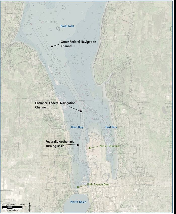
< Intentionally Blank >

CAPITOL LAKECAPITOL
                                                                                 – DESCHUTES   ESTUARY ESTUARY
                                                                                        LAKE – DESCHUTES
                                                                    Long-Term Management Project Environmental Impact       StatementImpact Statement
                                                                                          Long-Term Management Project   Environmental

Executive Summary

This Navigation Discipline Report evaluates the potential impacts of the Capitol Lake – Deschutes
Estuary Long-Term Management Project on vessel navigation. Vessel navigation includes the ability to
access and berth at a dock or slip in the West Bay of Budd Inlet. Recreational vessel use of Capitol Lake
is addressed in the Land Use, Shorelines, and Recreation Discipline Report.

Impacts to vessel navigation are assessed based on the potential of project alternatives to interrupt or
change the number of vessels using existing vessel facilities or resources (i.e. the Port of Olympia, West
Bay marinas) or in the access patterns (i.e. channels) to these facilities. This analysis examines the No
Action Alternative as well as three build alternatives (Managed Lake, Estuary, and Hybrid).

Construction Impacts on Navigation

Construction would not impact vessel navigation in Budd Inlet as none of the build alternatives include
construction activities north of the 5th Avenue Dam. Initial dredging and other construction activities
would be conducted from staging areas; equipment would be located and maintained within the
Capitol Lake Basin or in adjacent upland park spaces. As a result, there would be no impacts from
construction on navigation under the Managed Lake, Estuary, or Hybrid Alternatives.

The No Action Alternative would not result in construction impacts on navigation because the project
would not be built. Potential impacts would be related to limited, ongoing maintenance of the 5th
Avenue Dam and ongoing sedimentation of the Capitol Lake – Deschutes Estuary. Ongoing existing
maintenance dredging is still anticipated to be completed by the U.S. Army Corps of Engineers
(USACE), Port, and West Bay marinas, but implementation of a long-term maintenance dredging
program would not occur. Therefore, operational impacts on navigation would be less than significant
for this alternative.

Operational Impacts on Navigation

The Managed Lake Alternative would not modify the general function or location of the 5 th Avenue
Dam, nor does it include dredging north of the dam in Budd Inlet. The study area would still observe

June 2021                                 Navigation Discipline Report                                                   Page ES-1
CAPITOL LAKE – DESCHUTES ESTUARY
Long-Term Management Project Environmental Impact Statement
sediment deposition and the USACE, Port, and private marinas would still be anticipated to conduct
existing maintenance dredging activities to maintain vessel access and berth use. Implementation of a
long-term maintenance dredging program in Budd Inlet’s West Bay would not occur under this
alternative (maintenance dredging would occur only within the Capitol Lake Basin) and operational
impacts on navigation under the Managed Lake Alternative would be less than significant.
Both the Estuary and Hybrid Alternatives would remove the 5th Avenue Dam and restore tidal
hydrology to the Capitol Lake Basin. These alternatives would reestablish sediment transport and
deposition patterns from the Deschutes River and Percival Creek watershed throughout the Capitol
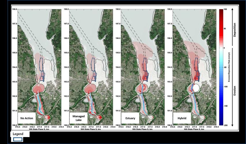
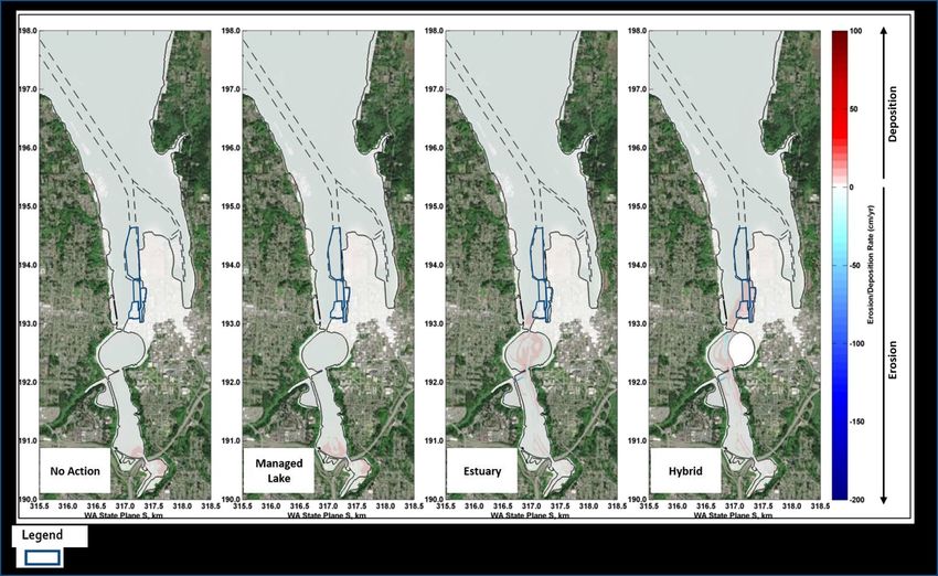
Lake Basin and Budd Inlet. The Estuary Alternative, compared to the No Action Alternative, would
increase sediment deposition within Budd Inlet under high river flow events. The Hybrid Alternative
would result in even higher rates of deposition within Budd Inlet compared to the Estuary Alternative.
Increased sediment deposition within West Bay would impact the ability of cargo ships to access
channels and berths at the Port of Olympia, requiring long wait times due to water depth and low tide
conditions. Sediment deposition would also impact the ability of smaller craft vessels to access and use
West Bay marina slips due to water depth. For these reasons, the Estuary and Hybrid Alternatives
include initial dredging of the Capitol Lake Basin (resulting in a 48% reduction in impacts to
sedimentation) to reduce initial sediment load and long-term maintenance dredging to reduce impacts
to navigation and the implementation of a long-term maintenance dredging program.
Impacts to navigation from sediment deposition are considered significant if large commercial vessels
accessing the Federal Navigation Channel (FNC) and Port would be required to wait longer than four
hours for channel access due to water depth and low tide conditions caused by sediment deposition; or,
if over 10% of anticipated small craft vessels would not be able to access their marina slip for moorage
due to water depth caused by sediment deposition. An annual sediment monitoring plan is proposed to
record sediment deposition changes allowing for maintenance dredging events to be scheduled to
occur prior to reaching levels of significance. The incorporation of initial dredging and an adaptable
long-term maintenance dredging program, combined with the implementation of a data-driven
sediment monitoring plan, could reduce significant impacts to less than significant under the Estuary
and Hybrid Alternatives.
Maintenance dredging, as part of the long-term maintenance dredging program, is expected to occur
once every six years or more under the Estuary Alternative and once every five years or more under the
Hybrid Alternative, depending on sediment deposition, over the 30-year time horizon, with the location
of maintenance dredging rotating throughout West Bay to address impacted areas. Not every facility
would be dredged during each occurrence, only those with impacted slips or berths that exceed the
significance threshold. The long-term maintenance dredging program for both alternatives will require
the USACE, Port, and West Bay marinas to schedule and coordinate berth and slip use around these
events. Maintenance dredging at the Port or within the FNC Entrance Channel or turning basin will
require coordination of cargo vessel calls and/or call interruptions. Maintenance dredging at the West
Bay marinas could require slip vacancies for temporary periods of time. In tight marina spaces, piles or
floats may need to be removed during dredging and boathouses may need to be relocated.
June 2021 Navigation Discipline Report Page ES-2
CAPITOL LAKE – DESCHUTES ESTUARY
                                                                    Long-Term Management Project Environmental Impact   Statement

Impacts to navigation from a long-term maintenance dredging program are considered significant if
large commercial vessels accessing the FNC and Port would be required to wait longer than four hours
for channel access due to maintenance dredging activities or equipment, or if over 10% of anticipated
small craft vessels would not be able to access their marina slip for moorage due to maintenance
dredging activities or equipment. The benefits of monitoring and regular implementation of an
adaptable long-term maintenance dredging program enable careful scheduling and planning to be
incorporated into a dredge event. Monitoring ensures that maintenance dredging occurs as the
significance threshold is approached and not exceeded. Maintenance dredging at the Port could be
phased to avoid impacting more than one berth at a time and care with scheduling could minimize the
potential for cargo vessel call delays. West Bay marinas could move vessels to different slips to conduct
maintenance dredging in one location, then move those vessels back to work at another dock or access
area. Boathouses located in shoaled areas requiring maintenance dredging could also be temporarily
relocated within the marina or nearby prior to maintenance dredging. These measures would reduce
the potential for significant impacts from the long-term maintenance dredging program on vessel
navigation under the Estuary and Hybrid Alternatives to less than significant impacts.

Under the Estuary and Hybrid Alternatives, the implementation of a long-term maintenance dredging
program would address the need for regular maintenance dredging faced under these alternatives and
would result in maintenance dredging being completed with regularity, which does not occur at all
locations in West Bay at this time. Under the Estuary and Hybrid Alternatives, a long-term
management program is incorporated into the project itself and supplemented with an annual
sediment monitoring plan, which would enable sediment accumulation conditions that interrupt vessel
access or berthing to be identified early. Therefore, long-term sediment management and monitoring
could provide a minor beneficial effect on navigation under the Estuary and Hybrid Alternatives.

Operations impacts of the No Action, Managed Lake, Estuary, and Hybrid Alternatives are summarized
in Table ES.1.

Table ES.1 Summary of Operations Impacts (including Benefits) and Mitigation Measures

No Action Alternative

                                                                                                  Significant and
                                                        Mitigation Proposed for                    Unavoidable
                              Impact Finding          Significant Adverse Impacts                 Adverse Impact
 Sediment deposition –      Less-Than-             None                                           N/A
 impacts on vessel          Significant
 access and berthing

June 2021                                 Navigation Discipline Report                                            Page ES-3
CAPITOL LAKE – DESCHUTES ESTUARY
                                                                     Long-Term Management Project Environmental Impact   Statement

Managed Lake Alternative

                                                                                                   Significant and
                                                         Mitigation Proposed for                    Unavoidable
                              Impact Finding           Significant Adverse Impacts                 Adverse Impact
 Sediment deposition –      Less-Than-              None                                           N/A
 impacts on vessel          Significant
 access and berthing

Estuary Alternative

                                                                                                   Significant and
                                                         Mitigation Proposed for                    Unavoidable
                              Impact Finding           Significant Adverse Impacts                 Adverse Impact
 Sediment deposition –      Significant             Implement monitoring to                        No
 impacts on vessel          Significant impacts     document initial conditions within
 access and berthing        reduced to less-than-   West Bay and monitor sediment
                            significant with        accumulation to identify when the
                            mitigation              FNC, turning basin, Port, and
                                                    marinas are nearing the threshold
                                                    that triggers maintenance
                                                    dredging.
                            Minor Beneficial
                            Effects related to a
                            long-term
                            maintenance
                            dredging program
 Maintenance dredging       Significant             As part of the long-term                       No
 – impacts on vessel        Significant impacts     maintenance dredging program,
 access and berth or slip   reduced to less-than-   implement scheduling and
 use                        significant with        phasing to minimize impacts to
                            mitigation              existing Port and marina
                                                    operations.

June 2021                                  Navigation Discipline Report                                            Page ES-4
CAPITOL LAKE – DESCHUTES ESTUARY
                                                                     Long-Term Management Project Environmental Impact   Statement

Hybrid Alternative

                                                                                                   Significant and
                                                         Mitigation Proposed for                    Unavoidable
                              Impact Finding           Significant Adverse Impacts                 Adverse Impact
 Sediment deposition –      Significant             Implement monitoring to                        No
 impacts on vessel          Significant impacts     document initial conditions within
 access and berthing        reduced to less-than-   West Bay and monitor sediment
                            significant with        accumulation to identify when the
                            mitigation              FNC, turning basin, Port, and
                                                    marinas are nearing the threshold
                                                    that triggers maintenance
                                                    dredging.
                            Minor Beneficial
                            Effects related to a
                            long-term
                            maintenance
                            dredging program
 Maintenance dredging       Significant             As part of the long-term                       No
 – impacts on vessel        Significant impacts     maintenance dredging program,
 access and berth or slip   reduced to less-than-   implement scheduling and
 use                        significant with        phasing to minimize impacts to
                            mitigation              existing Port and marina
                                                    operations.

June 2021                                  Navigation Discipline Report                                            Page ES-5
CAPITOL LAKE CAPITOL
                                                                          – DESCHUTES    ESTUARY ESTUARY
                                                                                  LAKE – DESCHUTES
                                                             Long-Term Management Project Environmental Impact Statement
                                                                                   Long-Term Management Project   Environmental Impact Statement

Table of Contents

Executive Summary                                                                                           ES-1

1.0 Introduction and Project Description                                                                          1-1
            1.1 PROJECT DESCRIPTION                                                                                 1-1

            1.2 SUMMARY OF PROJECT ALTERNATIVES                                                                     1-3

            1.3 CONSTRUCTION METHODS FOR THE ACTION ALTERNATIVES                                                    1-4

2.0 Regulatory Context                                                                                            2-1
            2.1 RESOURCE DESCRIPTION                                                                                2-1

            2.2 RELEVANT LAWS, PLANS, AND POLICIES                                                                  2-1

3.0 Methodology                                                                                                   3-1
            3.1 SELECTION OF THE STUDY AREA                                                                         3-1

            3.2 DATA SOURCES AND COLLECTION                                                                         3-3

            3.3 ANALYSIS OF IMPACTS                                                                                 3-4

4.0 Affected Environment                                                                                          4-1
            4.1 NAVIGATION RESOURCES AND FACILITIES                                                                 4-1

            4.2 NAVIGATION PATTERNS                                                                                 4-6

June 2021                          Navigation Discipline Report                                                       Page i
CAPITOL LAKE – DESCHUTES ESTUARY
                                                                    Long-Term Management Project Environmental Impact Statement

            4.3 SEDIMENT DEPOSITION AND EROSION RATES                                                               4-8

            4.4 EXISTING MAINTENANCE DREDGING                                                                      4-10

5.0 Impacts and Mitigation Measures                                                                               5-1
            5.1 OVERVIEW                                                                                            5-1

            5.2 NO ACTION ALTERNATIVE                                                                               5-1

            5.3 IMPACTS COMMON TO ALL BUILD ALTERNATIVES                                                            5-4

            5.4 MANAGED LAKE ALTERNATIVE                                                                            5-4

            5.5 ESTUARY ALTERNATIVE                                                                                 5-6

            5.6 HYBRID ALTERNATIVE                                                                                 5-15

            5.7 AVOIDANCE, MINIMIZATION, AND MITIGATION MEASURES                                                   5-21

6.0 References                                                                                                    6-1

Exhibits
Tables
Table ES.1 Summary of Operations Impacts (including Benefits) and Mitigation Measures                              ES-3
Table 2.1 Federal Laws, Plans, and Policies                                                                        2-2
Table 2.2 State Plans and Policies                                                                                 2-3
Table 2.3 Local Plans and Policies                                                                                 2-3
Table 4.1 Existing Sediment Deposition in Budd Inlet (Corresponds to No the Action Alternative in Moffatt
                 & Nichol 2020)                                                                      4-10
Table 5.1 Average Annual Sediment Deposition in Budd Inlet for the No Action Alternative with and without
               0.61 m RSLR                                                                         5-2
Table 5.2 No Action Alternative Maintenance Dredging in West Bay                                                   5-3
Table 5.3 Average Annual Sediment Erosion/Deposition (cm/yr) in Budd Inlet for the Managed Lake
               Alternative with and without 0.61 m RSLR                                         5-5
Table 5.4 Average Annual Sediment Deposition (cm/yr) in Budd Inlet for the Estuary Alternative with and
               without 0.61 m RSLR                                                                  5-6
Table 5.5 Average Annual Sediment Erosion/Deposition in cm/yr for Modeling Events A and B with 0.61 m
               of RSLR                                                                          5-7

June 2021                                 Navigation Discipline Report                                                Page ii
CAPITOL LAKE – DESCHUTES ESTUARY
Long-Term Management Project Environmental Impact Statement
Table 5.6 Estuary Alternative Anticipated Maintenance Dredging in West Bay 5-11
Table 5.7 Maintenance Dredging Production Assumptions 5-12
Table 5.8 Average Annual Sediment Deposition (cm/yr) in Budd Inlet for the Hybrid and Estuary
Alternatives with and without 0.61 m RSLR 5-16
Table 5.9 Hybrid Alternative Anticipated Maintenance Dredging in West Bay 5-17
Figures
Figure 1.1 Project Area 1-2
Figure 3.1 Study Area 3-2
Figure 4.1 Resource Areas 4-3
Figure 4.2 Federal Navigation Channel 4-4
Figure 4.3 Lower West Bay Marinas 4-5
Figure 4.4 Budd Inlet Vessel Traffic Patterns 4-7
Figure 4.5 Bathymetric Surveys of the Federal Navigation Channel 4-8
Figure 4.6 Estimated Existing Average Annual Sediment Erosion/Deposition Rates (cm/yr) 4-9
Figure 5.1 Deschutes River Water Flows 5-2
Figure 5.2 Erosion/Deposition Pattern (cm/yr) for Event A with 0.61 m of RSLR 5-8
Figure 5.3. Erosion/Deposition Pattern (cm/yr) for Event B with 0.61 m or RSLR 5-9
June 2021 Navigation Discipline Report Page iiiCAPITOL LAKE – DESCHUTES ESTUARY
Long-Term Management Project Environmental Impact Statement
List of Acronyms and Abbreviations
Acronyms/
Abbreviations Definition
% percent
AIS Automatic Identification Systems
cm Centimeter
cm/yr Centimeters per year
cy Cubic yards
DMMP Dredged Material Management Program
EIS Environmental Impact Statement
Enterprise Services Washington State Department of Enterprise Services
FNC Federal Navigation Channel
ft Feet
LOA Length overall
LOTT Lacey, Olympia, Tumwater, and Thurston County
m Meter
MLLW Mean Lower Low Water
NAVD88 North American Vertical Datum of 1988
Port Port of Olympia
RSLR Relative sea level rise
SLR Sea level rise
WDFW Washington Department of Fish and Wildlife
WDNR Washington State Department of Natural Resources
USACE U.S. Army Corps of Engineers
USCG U.S. Coast Guard
USGS U.S. Geological Survey
VTS Vessel Traffic Service
June 2021 Navigation Discipline Report Page ivCAPITOL LAKECAPITOL
– DESCHUTES ESTUARY ESTUARY
LAKE – DESCHUTES
Long-Term Management Project Environmental
Long-Term Impact
Management Project StatementImpact Statement
Environmental
1.0 Introduction and Project Description
1.1 PROJECT DESCRIPTION
The Capitol Lake – Deschutes Estuary includes the 260-acre Capitol Lake Basin, located on the
Washington State Capitol Campus, in Olympia, Washington. The waterbody has long been a valued
community amenity. Capitol Lake was formed in 1951 following construction of a dam and provided an
important recreational resource. Historically, the Deschutes Estuary was used by local tribes for
subsistence and ceremonial purposes. Today, the expansive waterbody is closed to active public use.
There are a number of environmental issues including the presence of invasive species, exceedances of
water quality (WQ) standards, and inadequate sediment management.
The Washington State Department of Enterprise Services (Enterprise Services) is responsible for the
stewardship, preservation, operation, and maintenance of the Capitol Lake Basin. The 260-acre Capitol
Lake Basin is maintained by Enterprise Services under long-term lease agreement from the Washington
Department of Natural Resources.
In 2016, as part of Phase 1 of long-term planning, a diverse group of stakeholders, in collaboration with
the state, identified shared goals for long-term management and agreed an Environmental Impact
Statement (EIS) was needed to evaluate a range of alternatives and identify a preferred alternative. In
2018, the state began the EIS process. The EIS evaluates four alternatives, including a Managed Lake,
Estuary, Hybrid, and a No Action Alternative.
The long-term management alternatives are evaluated against the shared project goals of improving
water quality; managing sediment accumulation and future deposition; improving ecological functions;
and enhancing community use of the resource. Refer to Figure 1.1 for the project area for long-term
management. The Final EIS will identify a preferred environmentally and economically sustainable
long-term management alternative for the Capitol Lake – Deschutes Estuary.
The EIS process maintains engagement with the existing Work Groups, which include the local
governments, resource agencies, and tribe. It also provides for expanded engagement opportunities for
the public, such as a community sounding board. The EIS process maintains engagement with the
existing Work Groups, which include the local governments, resource agencies, and the Squaxin Island
Tribe. It also provides for expanded engagement opportunities for the public, such as a community
sounding board.
June 2021 Navigation Discipline Report Page 1-1CAPITOL LAKE – DESCHUTES ESTUARY
Long-Term Management Project Environmental Impact Statement
Figure 0.11.1
Figure Project AreaArea
Project
Port of
West Bay Olympia
(Budd Inlet)
Fifth
Avenue Heritage
Dam Park
North Basin
(Reflecting Pool)
Marathon
Park
Capitol
Campus 5
Deschutes
e
tat
Parkway
ers
Int
Middle
Basin
Interpretive
Park
South Basin
Tumwater Deschutes
Falls River
¹
0 625 1,250 2,500
Scale in Feet
June 2021 Navigation Discipline Report Page 1-2CAPITOL LAKE – DESCHUTES ESTUARY
Long-Term Management Project Environmental Impact Statement
1.2 SUMMARY OF PROJECT ALTERNATIVES
1.2.1 Managed Lake Alternative
The Managed Lake Alternative would retain the 5th Avenue Dam in its existing configuration. The 5th
Avenue Dam would be overhauled to significantly extend the serviceable life of the structure. The
reflecting pool within the North Basin would be maintained, and active recreational use would be
restored in this area. Sediment would be managed through initial construction dredging and recurring
maintenance dredging in the North Basin only. Sediment from construction dredging would be used to
create habitat areas in the Middle Basin to support improved ecological function, habitat complexity,
and diversity. Sediment would continue to accumulate and over time would promote a transition to
freshwater wetlands in the South and Middle Basins. Boardwalks, a 5th Avenue Pedestrian Bridge, a
dock, and a boat launch would be constructed for community use.
If selected as the Preferred Alternative, adaptive management plans would be developed to maintain
water quality, improve ecological functions, and manage invasive species during the design and
permitting process.
1.2.2 Estuary Alternative
Under the Estuary Alternative, the 5th Avenue Dam would be removed, and an approximately 500-foot-
wide (150-meter-wide) opening would be established in its place. This would reintroduce tidal
hydrology to the Capitol Lake Basin, returning the area to estuarine conditions where saltwater from
Budd Inlet would mix with freshwater from the Deschutes River. Sediment would be managed through
initial construction dredging in the Capitol Lake Basin and recurring maintenance dredging within West
Bay. Dredged materials from construction dredging would be used to create habitat areas in the Middle
and North Basins to promote ecological diversity, though tideflats would be the predominant habitat
type. Boardwalks, a 5th Avenue Pedestrian Bridge, a dock, and a boat launch would be constructed for
community use. This alternative also includes stabilization along the entire length of Deschutes
Parkway to avoid undercutting or destabilization from the tidal flow. Existing utilities and other
infrastructure would be upgraded and/or protected from reintroduced tidal hydrology and saltwater
conditions.
If selected as the Preferred Alternative, adaptive management plans would be developed to improve
ecological functions and manage invasive species during the design and permitting process.
1.2.3 Hybrid Alternative
Under the Hybrid Alternative, the 5th Avenue Dam would be removed, and an approximately 500-foot-
wide (150-meter-wide) opening would be established in its place. Tidal hydrology would be
reintroduced to the western portion of the North Basin and to the Middle and South Basins. Within the
North Basin, a curved and approximately 2,600-foot-long (790-meter-long) barrier wall with a walkway
would be constructed to create an approximately 45‐acre saltwater reflecting pool adjacent to Heritage
Park. A freshwater (groundwater-fed) reflecting pool was also evaluated for this EIS. Construction and
June 2021 Navigation Discipline Report Page 1-3CAPITOL LAKE – DESCHUTES ESTUARY
Long-Term Management Project Environmental Impact Statement
maintenance of this smaller reflecting pool, in addition to restored estuarine conditions in part of the
Capitol Lake Basin, gives this alternative its classification as a hybrid. Sediment would be managed
through initial construction dredging in the Capitol Lake Basin and recurring maintenance dredging
within West Bay. In the Middle and North Basins, constructed habitat areas would promote ecological
diversity, though tideflats would be the predominant habitat type. Boardwalks, a 5th Avenue Pedestrian
Bridge, a dock, and a boat launch would be constructed for community use. This alternative also
includes stabilization along the entire length of Deschutes Parkway to avoid scour or destabilization.
Existing utilities and other infrastructure would be upgraded and/or protected from reintroduced tidal
hydrology and saltwater conditions.
If selected as the Preferred Alternative, adaptive management plans would be developed before
operation of the alternative to improve ecological functions and manage invasive species during the
design and permitting process. Adaptive management would also be needed for a freshwater reflecting
pool, but not for a saltwater reflecting pool.
1.2.4 No Action Alternative
The No Action Alternative represents the most likely future expected in the absence of implementing a
long-term management project. The No Action Alternative would persist if a Preferred Alternative is
not identified and/or if funding is not acquired to implement the Preferred Alternative. A No Action
Alternative is a required element in a SEPA EIS and provides a baseline against which the impacts of the
action alternatives (Managed Lake, Estuary, Hybrid) can be evaluated and compared.
The No Action Alternative would retain the 5th Avenue Dam in its current configuration, with limited
repair and maintenance activities, consistent with the scope and scale of those that have received
funding and environmental approvals over the past 30 years. In the last 30 years, the repair and
maintenance activities have been limited to emergency or high-priority actions, which occur
sporadically as a result of need and funding appropriations.
Although Enterprise Services would not implement a long-term management project, current
management activities and ongoing projects in the Capitol Lake Basin would continue. Enterprise
Services would continue to implement limited nuisance and invasive species management strategies.
In the absence of a long-term management project, it is unlikely that Enterprise Services would be able
to procure funding and approvals to manage sediment, improve water quality, improve ecological
functions, or enhance community use. The No Action Alternative does not achieve the project goals.
1.3 CONSTRUCTION METHODS FOR THE ACTION ALTERNATIVES
This impact analysis relies on the construction method and anticipated duration for the action
alternatives, which are described in detail in Chapter 2 of the EIS.
June 2021 Navigation Discipline Report Page 1-4CAPITOL LAKECAPITOL
– DESCHUTES ESTUARY ESTUARY
LAKE – DESCHUTES
Long-Term Management Project Environmental
Long-Term Impact
Management Project StatementImpact Statement
Environmental
2.0 Regulatory Context
2.1 RESOURCE DESCRIPTION
This discipline report addresses vessel navigation. Vessel navigation includes the ability to access and
use berths and slips within port and marina facilities. Navigation refers to marine vessel use in Lower
Budd Inlet and West Bay.
2.2 RELEVANT LAWS, PLANS, AND POLICIES
Vessel navigation is regulated by a variety of federal and state laws, plans, and policies (Section 2.2.1)
and local plans and policies (Section 2.2.2).
2.2.1 Federal and State
The federal and state laws, plans, and policies applicable to vessel navigation in Budd Inlet are
identified and briefly described in Table 2.1 and Table 2.2. Most enforcement of the federal and state
regulations fall to the U.S. Coast Guard (USCG), which supervises and enforces vessels operating in U.S.
navigable waters to ensure safe navigation.
Navigable servitude entitles the federal government to exert a dominant servitude in all lands below
the ordinary high water mark of navigable waters and a right to regulate navigable waterways as an
extension of the Commerce Clause in Article I, Section 8 of the U. S. Constitution.
The U.S. Army Corps of Engineers (USACE), through its Civil Works Program, authorizes a number of
U.S. water resources that support navigation. The USACE Section 408 process provides a mechanism
for local stakeholders to modify, occupy, or alter an existing and constructed USACE Civil Works
project. Projects can include navigational channels, breakwaters, basins, levees, etc. The purpose of
Section 408 is to ensure that an alteration to an existing USACE Civil Works project does not adversely
impact the public interest or undermine the federally authorized benefits of the USACE project.
An existing Federal Navigation Channel (FNC), affiliated federal access channels, and a turning basin
are located within Budd Inlet and provide vessel access to facilities in both West and East Bay
June 2021 Navigation Discipline Report Page 2-1CAPITOL LAKE – DESCHUTES ESTUARY
Long-Term Management Project Environmental Impact Statement
(described in more detail in Section 4.0). Impacts on the FNC (i.e. sediment erosion/deposition rates)
would be regulated under Section 408 and evaluated for effects to structural integrity, operation and
maintenance, and USACE policy and criteria.
Table 2.1 Federal Laws, Plans, and Policies
Regulatory Program
or Policies Lead Agency Description
Federal Navigable U.S. Entitles the federal government to exert a dominant
Servitude Government servitude in all lands below the ordinary high water mark of
navigable waters and a right to regulate navigable
waterways.
Federal Pilotage USCG Identifies the type of vessels that require a federally
Requirements licensed master or mate and federal pilotage requirements
(46 CFR 15.610 and for U.S.-inspected vessels on coastwise voyages.
15.812)
Navigation and USCG Applies to all vessels on the inland waters of the U.S.
Navigable Waters, Complements the International Regulations for Preventing
Subchapter E: Inland Collisions at Sea 1972, applicable in International Waters.
Navigation Rules
(33 CFR 83 ‒90)
Notice to Mariners USCG Issues information concerning the establishment of aids to
maritime navigation and the changes, discontinuances,
and deficiencies, except temporary deficiencies that are
easily correctable, of aids to maritime navigation
maintained and operated by or under the authority of the
USCG.
Port and Tanker USCG Grants USCG authority to supervise and control vessels,
Safety Act of 1978 foreign and domestic, operating in U.S. navigable waters.
(33 U.S.C. 1221 et
seq.)
Ports and Waterways USCG Authorizes the USCG to provide for navigation and vessel
Safety Act of 1972 safety; protect the marine environment; and protect life,
(31 U.S.C. 1221 et property, and structures in, on, or adjacent to U.S.
seq.) navigable waters.
Section 14 of the USACE Provides a mechanism for others to modify, occupy, or
Rivers and Harbors alter an existing USACE constructed public works project.
Act of 1899
(33 USC 408),
(Section 408)
June 2021 Navigation Discipline Report Page 2-2CAPITOL LAKE – DESCHUTES ESTUARY
Long-Term Management Project Environmental Impact Statement
Table 2.2 State Plans and Policies
Regulatory Program
or Policies Lead Agency Description
Vessel Traffic Service USCG The USCG Vessel Traffic Service (VTS) regulates vessel
traffic and safety in Puget Sound by monitoring and
directing vessel movements to maintain appropriate
navigation corridors and vessel transit separation, with
the coincident benefit of minimizing shipping
interruptions and delays.
Washington State USCG Identifies requirements for compulsory pilotage
Pilotage Act provisions in certain waters of the state, including Puget
(RCW 88.16) Sound.
2.2.2 Local
Key local plans and policies applicable to vessel navigation in Budd Inlet are identified and briefly
described Table 2.3. Other, more specific, rules may also apply at individual facilities (i.e. the Port and
individual private marinas).
The Port of Olympia’s primary planning document, the Comprehensive Scheme of Harbor
Improvements (Port of Olympia 2017a), consists of development guidelines and a comprehensive
scheme of harbor improvements. The Development Guidelines detail information on existing
properties and long-range development plans within the Port’s Use Districts (Port of Olympia 2017b).
The Comprehensive Scheme of Harbor Improvements includes a description of anticipated future
projects. The Port’s Strategic Plan aims to provide organizational clarity, guide the Port, and act as a
tool to communicate with staff, stakeholders, customers, and the community about the vision, role,
and focus of the Port (Port of Olympia 2017c). The Port’s Vision 2050 Plan includes comprehensive
public engagement that helps shape long-range goals and priority actions (Port of Olympia 2019).
Table 2.3 Local Plans and Policies
Regulatory Program
or Policies Lead Agency Description
Puget Sound Harbor Puget Sound Establishes a set of Standards of Care for the Puget Sound
Safety Plan Harbor Safety area that supplement existing federal, state, and local
Committee with laws.
USCG
June 2021 Navigation Discipline Report Page 2-3CAPITOL LAKE – DESCHUTES ESTUARY
Long-Term Management Project Environmental Impact Statement
Regulatory Program
or Policies Lead Agency Description
Olympia Sea Level City of Olympia, Provides comprehensive strategies for minimizing and
Rise Response Plan LOTT1 Clean preventing flooding to downtown.
(2019) Water Alliance,
Port of Olympia
Vessel Speed Limit City of Olympia It is unlawful for any person to operate or have control
over watercraft within city waters that travels at a speed
greater than 7 knots (7 nautical miles per hour) in those
waters north of an east/west line transecting the tip of the
Port peninsula, or which travels at a speed greater than 5
knots (5 nautical miles per hour) in waters south of said
line. It is further unlawful to operate in such a manner to
cause a wake that endangers or jeopardizes property or
persons within the immediate vicinity.
Olympia Harbor Operates under The Olympia Harbor Patrol is comprised of volunteers
Patrol Swantown that help protect the security and safety of Swantown
Marina to Port Marina and Boatworks, the marine terminal, Port
of Olympia customers, and citizens utilizing the waterfront.
Comprehensive Port of Olympia The Port’s primary planning document.
Scheme Harbor
Improvements (2017)
Development Port of Olympia Provides information on existing properties and long-
Guidelines (2017) range plans for development within the Port’s Use
Districts.
Strategic Plan (2017) Port of Olympia Aims to provide organizational clarity, guide the Port, and
acts as a tool to communicate with staff, stakeholders,
customers, and the community about the vision, role, and
focus of the Port of Olympia.
Vision 2050 Port of Port of Olympia Developed through comprehensive public engagement to
Olympia (2019) help shape long-range Port goals and priority actions.
1
LOTT is a non-profit corporation that functions like a public agency and includes four partner jurisdictions – the
cities of Lacey, Olympia, Tumwater, and Thurston County.
June 2021 Navigation Discipline Report Page 2-4CAPITOL LAKECAPITOL
– DESCHUTES ESTUARY ESTUARY
LAKE – DESCHUTES
Long-Term Management Project Environmental
Long-Term Impact
Management Project StatementImpact Statement
Environmental
3.0 Methodology
3.1 SELECTION OF THE STUDY AREA
The study area for navigation consists of areas that could be directly or indirectly affected by operation
of the project and changes in sediment movement (Figure 3.1), this includes the West Bay of Budd Inlet.
The southern boundary of the study area is located at 5th Avenue. The northern boundary of the study
area is located at the end of the peninsula between West and East Bay, the east and west of the study
area are bounded by adjacent shorelines of West Bay. The northern limit of the study area is based on:
• The hydrodynamic and sediment transport modeling (Moffatt & Nichol 2020) and the extent of
sediment deposition into Budd Inlet by the build alternatives; and
• The extent of the impacts of sediment transport given the location of water-dependent
businesses in West Bay.
The study area for navigation does not include Capitol Lake. Navigation in the lake is recreational and
these impacts are addressed in the Land Use, Shorelines, and Recreation Discipline Report.
June 2021 Navigation Discipline Report Page 3-1CAPITOL LAKE – DESCHUTES ESTUARY
Long-Term Management Project Environmental Impact Statement
Figure 3.1 Study Area
June 2021 Navigation Discipline Report Page 3-2CAPITOL LAKE – DESCHUTES ESTUARY
Long-Term Management Project Environmental Impact Statement
3.2 DATA SOURCES AND COLLECTION
Data sources used for navigation analysis include existing navigation patterns for the study area, vessel
use, depth, hydrodynamics, sediment erosion/deposition rates for the study area, and existing
maintenance dredging data from the Port of Olympia, USACE, and a number of private marinas located
in West Bay.
3.2.1 Navigation Patterns
Information about existing vessel navigation patterns was obtained from shipborne Automatic
Identification Systems (AIS). AIS is a real-time network of transmitters and receivers that broadcast,
track, and record vessel movement. AIS tracking beacons are located on ships only, not on barges that
may be towed by tugs within the waterway or smaller boats. AIS devices are required for many larger
commercial vessels (including cargo ships, tugboats, vessels engaged in dredging operations, and
larger fishing vessels). This collected data is used to establish and evaluate the movement of larger
vessels that use the FNC to access the Port of Olympia.
3.2.2 Sediment Deposition Rates
The comparison of past and present bathymetric condition surveys and hydrodynamic and sediment
transport numerical modeling (Moffatt & Nichol 2020) resulted in sediment deposition rates for Budd
Inlet that were then used to define the study area for navigation analysis and to develop the proposed
long-term maintenance dredging program for impacted areas of West Bay.
3.2.3 Existing Maintenance Dredging
Information on existing navigational conditions was gathered by contacting the Port of Olympia,
USACE, and a number of private marinas in West Bay (Fiddlehead Marina, Martin Marina, and Olympia
Yacht Club). Information on the types of vessels, incidents of vessel grounding, operations, navigational
constraints, sediment deposition, and long-term plans for accommodating different types of vessels
was obtained from these stakeholders.
This outreach was used to evaluate existing maintenance dredging frequencies and known plans for
future maintenance dredging by these different entities. Through this outreach, it was identified that,
based on the federal navigational servitude doctrine and requirement of Washington State Department
of Natural Resources (WDNR) lease renewals, USACE and marina-led dredging is expected to occur at
these facilities within the next 10 years, prior to, or at implementation of, any of the proposed action
alternatives. The anticipated dredging, completed by these entities and separate from the Project,
would reach authorized depths within the FNC, Port berths, marinas, and marina access areas.
This information was then used to better understand the potential frequency of existing maintenance
dredging by these entities under the No Action Alternative, and in comparison, to develop the trigger
for and frequency of long-term maintenance dredging under the Estuary and Hybrid Alternatives.
June 2021 Navigation Discipline Report Page 3-3CAPITOL LAKE – DESCHUTES ESTUARY
Long-Term Management Project Environmental Impact Statement
3.3 ANALYSIS OF IMPACTS
Impacts of the project on vessel navigation are analyzed for the three build alternatives and the No
Action Alternative. Both the Estuary and Hybrid Alternatives are designed to remove the 5th Avenue
Dam, restore tidal hydrology to the Capitol Lake Basin system, and incorporate elements that manage
sedimentation into Budd Inlet to maintain vessel navigation in West Bay. Impacts of the project on
vessel navigation could be either adverse or beneficial.
3.3.1 Identification of Construction Impacts
The three build alternatives do not propose construction activities north of the 5th Avenue Dam in areas
that could affect vessel navigation. As a result, short-term (construction) impacts are not evaluated.
3.3.2 Identification of Operational Impacts
Operational impacts could include increases in sedimentation that limit or block access or use of vessel
channels, berths, and slips over time. Maintenance dredging activities may do the same and limit or
block access or use of vessel channels, berths, and slips over time. Impacts analysis considers two
potential impacts to vessel navigation to the facilities located within the study area:
• Impacts on vessel access and berthing due to sediment deposition; and
• Impacts on vessel access and berth or slip use due to long-term maintenance dredging.
Operational impacts could be either adverse or beneficial. Operational impacts to vessel navigation are
assessed both qualitatively and quantitatively, incorporating results from hydrodynamic and sediment
transport modeling (Moffatt & Nichol 2020), and data collected from the Port, USACE, and private
vessel moorage facilities in West Bay.
3.3.2.1 Impacts on Navigation from Sediment Deposition
The magnitude of operational adverse impacts on vessel navigation from sediment deposition or
implementation of a long-term maintenance dredging program is considered less-than-significant or
significant for this analysis as follows:
• Less-than-Significant―Impacts are considered less than significant if the project results in no
change or limited restrictions in vessel access to berthing and moorage facilities, or in the use of
these facilities, in West Bay.
• Significant―Impacts are considered significant if vessel navigation would be so adversely
affected by sediment accumulation within the study area that:
o Large vessels accessing the FNC and Port would be required to wait longer than four (4)
hours for channel access due to water depth and low tide conditions caused by
sediment deposition on more than one consecutive occasion; or
June 2021 Navigation Discipline Report Page 3-4CAPITOL LAKE – DESCHUTES ESTUARY
Long-Term Management Project Environmental Impact Statement
o Over 10% of anticipated small craft vessels would not be able to access a slip for
moorage due to water depth caused by sediment deposition.
• Beneficial―Impacts are considered beneficial if vessel access to berthing and moorage
facilities in West Bay is improved.
3.3.2.2 Impacts on Navigation from Long-term Maintenance Dredging
The magnitude of operational adverse impacts on vessel navigation from long-term maintenance
dredging are considered less than significant or significant for this analysis as follows:
• Less than Significant―Impacts are considered less than significant if the project results in no
change or limited restrictions in vessel access to berthing and moorage facilities, or in the use of
these facilities, in West Bay.
• Significant―Impacts are considered significant if vessel navigation would be so adversely
affected by long-term maintenance dredging activities within the study area that:
o Large vessels accessing the Port would be required to wait longer than four (4) hours for
channel or berth access due to maintenance dredging equipment or activities on more
than one consecutive occasion during a dredge cycle; or
o Over 10% of anticipated small craft vessels would not be able to access a slip or
boathouse for moorage due to maintenance dredging equipment or activities.
• Beneficial―Impacts are considered beneficial if vessel access to berthing and moorage
facilities in West Bay are improved.
June 2021 Navigation Discipline Report Page 3-5CAPITOL LAKECAPITOL
– DESCHUTES ESTUARY ESTUARY
LAKE – DESCHUTES
Long-Term Management Project Environmental
Long-Term Impact
Management Project StatementImpact Statement
Environmental
4.0 Affected Environment
4.1 NAVIGATION RESOURCES AND FACILITIES
The study area for navigation includes Lower Budd Inlet, which is important for both commercial and
recreational vessels of varying size that support the local economy. Vessel navigation resources and
facilities include the southern portion of the existing USACE FNC and adjacent turning basin, the Port’s
three marine terminal berths, and access to the Olympia Yacht Club, private marinas, and public
moorage facilities in West Bay (Figure 4.1).
4.1.1 Federal Navigation Channel
An existing USACE FNC, affiliated federal access channels, and a turning basin are located within Budd
Inlet’s West and East Bays (Figure 4.2). The existing FNC and turning basin were originally authorized
by the Rivers and Harbors Act of January 21, 1927 and modified in subsequent Acts (USACE 2003). The
Outer Channel is authorized to 500 feet (ft) wide and 30 ft deep and branches into two channels, one to
East Bay and one to West Bay. The Entrance Channel into West Bay is authorized to 300 ft wide and 30
ft deep Mean Lower Low Water (MLLW) and continues to the west side of the Port, where the turning
basin provides for vessel maneuverability to the Port’s adjacent berths. The turning basin is authorized
to 3,350 ft long, 500 to 800 ft wide, and 30 ft deep (USACE 2003). The USACE is responsible for federal
channel maintenance to authorized depths and widths.
4.1.2 Port of Olympia
The Port of Olympia is comprised of 66 acres, including three deepwater marine terminal berths with a
total length of 1,750 ft and average water depth of 39 ft MLLW. Marine terminal services include cargo
loading/unloading, cargo handling, storage, and other related activities. Typical vessels calling at the
Port include bulk cargo ships (Port of Olympia project communications 2020). Exports include logs,
livestock, and feed supplies, which are reflected in ship calls to the Port (Port of Olympia project
communications, 2020). Import and export opportunity awards and losses of these types of services can
increase or decrease ship calls. Present markets are volatile and not easily predictable.
June 2021 Navigation Discipline Report Page 4-1CAPITOL LAKE – DESCHUTES ESTUARY
Long-Term Management Project Environmental Impact Statement
4.1.3 West Bay Marinas
West Bay marinas and docking facilities closest to the 5 th Avenue Dam include the Olympia Yacht Club,
Fiddlehead Marina, Martin Marina, and Percival Landing (Figure 4.3). Marina access areas allow for
access into these different marinas and moorage facilities, which vary in size, water depth, and services.
The Olympia Yacht Club is located closest to 5th Avenue Dam and provides permanent moorage for
approximately 237 vessels in 120 boathouses and 117 open slips. Approximately 250 ft of open dock
space is reserved for transient vessels (Olympia Yacht Club project communications, 2020).
Permanently moored vessels include both powerboats and sailboats, ranging from 24 to 73 ft long with
7 to 18-foot beams and 4 to 7-foot drafts. The Fiddlehead and Martin Marinas in West Bay are located
just north of the Olympia Yacht Club and offer moorage for 80 to 90 vessels and a few houseboats and
liveaboards (Fiddlehead Marina project communications, 2020; Martin Marina project communications,
2020). Draft for these facilities ranges from 2 to 7 ft, with beams of 8 to 12 ft, and a length overall (LOA)
from 15 to 50 ft. The City of Olympia’s Percival Landing Park is a waterfront park in downtown Olympia
that offers transient moorage at Docks D and E (Figure 4.3). Percival landing can accommodate vessels
up to 80 ft and offers approximately 36 slips. Moorage is offered on a first come, first served basis for
short periods of time.
Marina depth is commonly about 5 to 7 ft at MLLW, which is the depth required by environmental
regulations and WDNR leases. Marina depth in West Bay is estimated to average at about 7 ft MLLW
based on marina outreach (Fiddlehead Marina project communications, 2020; Martin Marina project
communications, 2020; Olympia Yacht Club project communications, 2020).
June 2021 Navigation Discipline Report Page 4-2CAPITOL LAKE – DESCHUTES ESTUARY
Long-Term Management Project Environmental Impact Statement
Figure 4.1 Resource Areas
June 2021 Navigation Discipline Report Page 4-3CAPITOL LAKE – DESCHUTES ESTUARY
Long-Term Management Project Environmental Impact Statement
Figure 4.2 Federal Navigation Channel
June 2021 Navigation Discipline Report Page 4-4CAPITOL LAKE – DESCHUTES ESTUARY
Long-Term Management Project Environmental Impact Statement
Figure 4.3 Lower West Bay Marinas
June 2021 Navigation Discipline Report Page 4-5CAPITOL LAKE – DESCHUTES ESTUARY
Long-Term Management Project Environmental Impact Statement
4.2 NAVIGATION PATTERNS
4.2.1 Federal Navigation Channel
The Port’s cargo vessel call records are reflected accurately in the AIS data record for the 2018 to 2019
period. The AIS data includes other vessels, not calling at the Port, representing a sample of the vessel
traffic for vessels where AIS reporting is optional. Figure 4.4 provides a summary representation of
vessel use of Budd Inlet into West Bay. The observable patterns reflect areas where vessel traffic
generally occurs. Areas not shaded may have occasional transits and should not be interpreted as
indicating a complete absence of vessel traffic (areas with 5 or fewer vessel passes per year are not
shaded and many recreational vessels do not have AIS that can be recorded by the system). Vessel
navigation was observed to be highest within the authorized FNC and turning basin and throughout the
east side of West Bay closest to the Port, local private marinas, and marina access areas along the east
shore of West Bay.
4.2.2 Port of Olympia
Vessels arriving at the Port of Olympia use the FNC and turning basin. Typical vessels calling at the Port
include bulk cargo ships of about 600 ft LOA and beams of around 100 ft. Given existing depths within
the FNC and turning basin, cargo vessels typically sail on a rising high tide (either of the diurnal high
tides) drawing around 32 ft (Port of Olympia project communications, 2020). Cargo vessels are also
presently known to lighten their loads when calling at Port due to existing sediment accumulation in
the FNC and turning basin. Port berth depth remains steady around 39 ft MLLW; and the Port and
USACE share concerns with already impacted depth in both the FNC and turning basin, which restricts
vessel size access to Port berths.
The Port has indicated they would like to welcome Panamax and Neopanamax vessels (ships designed
to the dimensions necessary to pass through the Panama Canal) to their berths, which could require
berth deepening and widening (not presently included in the Port’s near future planning documents).
This would also require coordination with the USACE as any deepening and/or widening of the FNC and
turning basin would require USACE authorization.
4.2.3 West Bay Marinas
Typical vessels calling at the West Bay marinas include recreational powerboats and sailboats
(Fiddlehead Marina project communications, 2020; Martin Marina project communications, 2020;
Olympia Yacht Club project communications, 2020). Percival Landing Park is used for short-term
moorage. There are two annual maritime-themed events that draw visitors each year: the Wooden
Boat Festival on Memorial Day and the Harbor Days over Labor Day.
June 2021 Navigation Discipline Report Page 4-6CAPITOL LAKE – DESCHUTES ESTUARY
Long-Term Management Project Environmental Impact Statement
Figure 4.4 Budd Inlet Vessel Traffic Patterns
June 2021 Navigation Discipline Report Page 4-7CAPITOL LAKE – DESCHUTES ESTUARY
Long-Term Management Project Environmental Impact Statement
4.3 SEDIMENT DEPOSITION AND EROSION RATES
Historical and recent patterns and rates of sediment deposition within Budd Inlet were estimated by
comparing available bathymetric surveys (Moffatt & Nichol 2020). The total and annual rates of
erosion/deposition are presented herein in meters (m) and centimeters per year (cm/yr), respectively,
unless noted otherwise.
4.3.1 Federal Navigation Channel and Port of Olympia
The USACE conducts periodic bathymetric condition surveys of the FNC and turning basin seafloor,
which allow for changes in sediment deposition and erosion to be identified. Bathymetric conditions
surveys are available dating back to 1998. These surveys were used to establish long-term spatial
patterns of rates of sediment erosion and deposition (Moffatt & Nichol 2020). Survey comparisons
show that the majority of the FNC has experienced sediment deposition ranging from 2 to 3 cm/yr
between 1998 to 2020 (22 years), although some erosion has been observed over the past nine years.
The turning basin has experienced sediment deposition of approximately 3 cm/yr in the 2011 to 2020
period, similar to the long-term trend observed for 1998 to 2020. Sedimentation rate studies have been
carried out for the Port and Budd Inlet by others (Landau 1993, SAIC 2008, and Anchor QEA 2013);
results from these studies show that the sedimentation rate is equal to approximately 0.12 to 1.1 cm/yr,
which is within the range of long-term rates obtained from USACE FNC survey comparisons (-1.0 to
+3.0 cm/yr). Bathymetric surveys of the FNC are shown in Figure 4.5. Based on survey comparison, the
average annual sediment erosion/deposition rate within the FNC for 1998 to 2020 varies spatially and
temporally between -1 to +4 cm/yr (Figure 4.6).
Figure 4.5 Bathymetric Surveys of the Federal
Navigation Channel
1998 2011 2020
June 2021 Navigation Discipline Report Page 4-8CAPITOL LAKE – DESCHUTES ESTUARY
Long-Term Management Project Environmental Impact Statement
Figure 4.6 Estimated Existing Average Annual
Sediment Erosion/Deposition Rates (cm/yr)
2020 - 1998 2020 - 2011 2011 - 1998
4.3.2 West Bay Marinas
Existing bathymetry information for the West Bay marinas was limited and average annual sediment
deposition rates could not be obtained by comparing bathymetric surveys. However, multiple marinas
report isolated areas of shoaling (Fiddlehead Marina, 2020, project communications; Martin Marina,
2020; project communications; Olympia Yacht Club, 2020, project communications). Average annual
sediment erosion and deposition rates for the Olympia Yacht Club (the marina located closest to the 5th
Avenue Dam) and other West Bay marinas were estimated based on the calibrated sediment transport
model developed for the study area (Moffatt & Nichol, 2020) and are summarized in Table 4.1.
4.3.3 Sediment Deposition Pattern Summary for West Bay
Annual sediment deposition/erosion rates within Budd Inlet are highly dependent on river flow events
with more extreme flow events depositing more sediments. However, higher sediment deposition rates
generally occur on the east side of West Bay during high flow events (Moffatt & Nichol 2020). This is
due to the presence of an area of shallow intertidal habitat along the remnants of an existing rail trestle
on the west side of Budd Inlet’s West Bay. This pattern of stronger deposition on the east side of West
Bay is consistent with findings of previous U.S. Geological Survey (USGS) studies (George et al. 2006
and Stevens et al. 2008).
Table 4.1 shows that the highest sediment deposition rate occurs at the Olympia Yacht Club (closest to
the 5th Avenue Dam) along with a pattern of decreasing sediment deposition with distance away from
the 5th Avenue Dam northward (Moffatt & Nichol 2020). Table 4.1 includes two conditions: without
relative sea level rise (RSLR) and with RSLR, which includes a 0.61 m future increase in RSLR.
Deposition and erosion rates are lower for with RSLR than that without RSLR conditions. This is likely
June 2021 Navigation Discipline Report Page 4-9CAPITOL LAKE – DESCHUTES ESTUARY
Long-Term Management Project Environmental Impact Statement
due to the higher water levels associated with RSLR resulting in reduced flow velocities and reduced
erosion of sediments in the Middle Basin, which results in reduced deposition in Budd Inlet.
Table 4.1 Existing Sediment Deposition in Budd Inlet (Corresponds to No the Action
Alternative in Moffatt & Nichol 2020)
Average Annual Average Annual Sediment
Sediment Deposition Deposition (cm/yr) with
Location (cm/yr) without RSLR RSLR
Olympia Yacht Club 4.3 3.4
Other West Bay Marinas and Marina
2.1 1.7
Access
Port/Turning Basin 2.2 1.6
FNC (excluding Turning Basin) 0.1 0.1
Rest of Budd Inlet (not within study area) 0.1 0.1
4.4 EXISTING MAINTENANCE DREDGING
4.4.1 Federal Navigation Channel and Port of Olympia
The USACE and Port of Olympia have shared that portions of the FNC and the turning basin would
benefit from further maintenance dredging as cargo vessels are presently known to lighten their loads
when calling at Port due to existing sediment accumulation in the FNC and turning basin (Port of
Olympia project communications, 2020). Given existing available USACE and Port data, maintenance
dredging at the Port of Olympia has occurred twice in the last 40 years (the USACE last conducted
maintenance dredging in 2007 and the Port in 2014 at their berths). USACE maintenance dredging
efforts have been delayed due to the chemical quality of the sediment, which would require the
sediment to be disposed of at a permitted upland facility. Disposal at an upland facility is not consistent
with federal standards that require that dredged material be disposed of using the least costly,
environmentally acceptable method, when possible (e.g. in-water or beneficial re-use). However,
chemical quality of the sediment is also a consideration for disposal.
Due to already impeded vessel navigation due to sediment accumulation, it is anticipated that existing
maintenance dredging is likely to be conducted again by the USACE in the FNC and turning basin, and
by the Port in their berths as necessary, within the next 10 years to meet existing authorized depths (-30
ft MLLW in the FNC and turning basin and -39 ft MLLW at the Port’s berths). Authorized dredge depth
is expected to remain consistent for 30-years, and not authorized for deepening and widening beyond
these depths.
4.4.2 West Bay Marinas
The Olympia Yacht Club last completed maintenance dredging of about 11,250 cy of material within
specific shallow portions of their marina in 2014; prior to this, maintenance dredging was completed in
June 2021 Navigation Discipline Report Page 4-10You can also read