Orica Southlands Remediation and Redevelopment, Banksmeadow Transport Assessment Review - Major Projects
←
→
Page content transcription
If your browser does not render page correctly, please read the page content below
Orica Southlands Remediation and
Redevelopment, Banksmeadow

Transport Assessment Review
July 2011

        S A M S A C O N S U LT I N G
  TRANSPORT PLANNING & TRAFFIC ENGINEERING
samsa
 _________________________________________________ consulting

Samsa Consulting Pty Ltd
Transport Planning / Traffic Engineering
ABN: 50 097 299 717
46 Riverside Drive, Sandringham, NSW 2219, AUSTRALIA
Telephone: (+61) 414 971 956 or (+612) 9583 2225
E-mail: alansamsa@telstra.com
Web: www.samsaconsulting.com

© Samsa Consulting Pty Ltd
This document is and shall remain the property of Samsa Consulting Pty Ltd. The document may only be used for the purposes for
which it was commissioned and in accordance with the Terms of Engagement for the commission. Unauthorised use of this document
in any form whatsoever is prohibited.

Orica Southlands Devt_transport             Orica Southlands Remediation & Redevelopment, Banksmeadow
                                                            Transport Assessment Review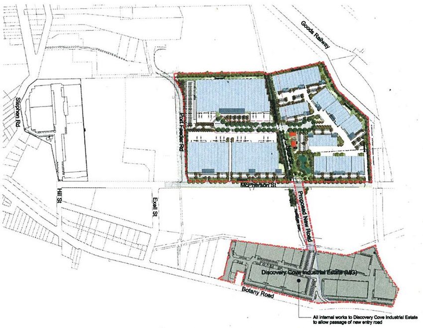
samsa
 _________________________________________________ consulting

Contents
1. Introduction .................................................................................................. 1
     1.1 Objectives & Scope of Work .............................................................................. 1
     1.2 Report Structure ................................................................................................ 3
2. Project Description ...................................................................................... 4
3. Review of Traffic & Access Assessment ................................................... 7
     3.1     Key Assessment Issues .................................................................................... 7
     3.2     Parking & Site Access ....................................................................................... 7
     3.3     Traffic Generation .............................................................................................. 8
     3.4     Road Network and Intersection Analysis ........................................................... 9
     3.5     Proposed Road Network Upgrades ................................................................. 11
     3.6     Alternative Transport ....................................................................................... 12
     3.7     Construction Phase Issues .............................................................................. 13
4. Stakeholder & Community Submissions ................................................. 14
     4.1     Submissions Received .................................................................................... 14
     4.2     Orica Response to Submissions ...................................................................... 18
     4.3     Further Consultations ...................................................................................... 20
     4.4     Preferred Project Plan ..................................................................................... 21
5. Conclusions & Recommendations ........................................................... 27
     5.1 Conclusions ..................................................................................................... 27
             5.1.1 Original Project Assessment ................................................................................ 27
             5.1.2 Preferred Project Plan .......................................................................................... 27
     5.2 Recommendations........................................................................................... 28

Orica Southlands Devt_transport                    Orica Southlands Remediation & Redevelopment, Banksmeadow
                                                                   Transport Assessment Review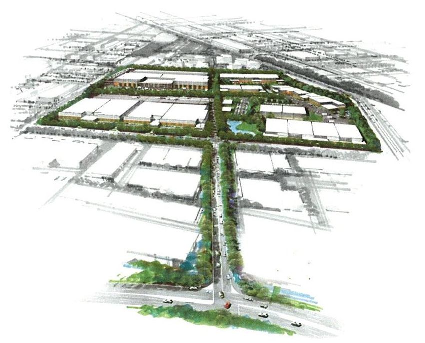
samsa
 _________________________________________________ consulting

1.             Introduction

               Orica is proposing to redevelop its Southlands site at McPherson Street, Banksmeadow for
               warehousing and distribution purposes under Part 3A of the Environmental Planning and
               Assessment Act, 1979. The project includes:
                        Remediation of the site, including the realignment of groundwater infrastructure
                        associated with the Botany Groundwater Cleanup Project.
                        Establishment of several warehouses over a number of stages, with a proposed
                        floor area of 79,190 m2 split up as follows:
                             - Stage 1: 47,000 m2 GFA
                             - Stage 2: 16,490 m2 GFA
                             - Stage 3: 15,700 m2 GFA
                        Associated infrastructure including:
                             - site access;
                             - upgrades to the Hill Street and Exell Street intersections at Botany Road;
                             - new road link to Botany Road;
                             - flood mitigation works;
                             - car parking; and
                             - landscape works.
               The EA identifies that the proposed development would increase the number of heavy
               vehicles on Hill Street, Exell Street and Botany Road to access the Southlands site. It is
               noted that Stage 3 of the proposal would be subject to further approvals, however, for the
               purposes of the assessing the traffic impacts for the proposal, traffic generated by Stage 3
               was included in the traffic assessment.
               This report details a review of the traffic and access assessment for the proposed Project
               and has been prepared by Samsa Consulting Pty Ltd, Transport Planning & Traffic
               Engineering Consultants, for NSW Department of Planning (DoP) as part of its project
               assessment process.

1.1            Objectives & Scope of Work

               Orica has indicated that the development for Stage 1 would require upgrades to both Hill
               Street and Exell Street at their Botany Road intersections. In addition, Orica is proposing a
               new road from the site to Botany Road via the Discovery Cove Estate, prior to their Stage 2
               development. An assessment of the proposed upgrades and the new road is required to
               establish whether the proposed works are appropriate.
               The DoP is currently assessing the application from Orica and requires independent
               technical advice with respect to the Project‟s transport assessment. This review has been
               carried out to provide the independent technical advice including:
                    1. Review of the Traffic and Transport Assessment, submitted as part of the EA,
                        prepared by URS (August 2009)
                    2. Review traffic and transport related issues in submissions received during the

Orica Southlands Devt_transport           Orica Southlands Remediation & Redevelopment, Banksmeadow
                                                          Transport Assessment Review                    1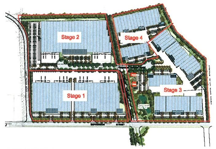
samsa
 _________________________________________________ consulting

                          public exhibition period.
                       3. Identify any additional information or clarification required from Orica to complete
                          an assessment of the application.
                       4. Provide an assessment report to the Department, including consideration of:
                              - existing transport conditions and potential impacts of the project;
                              - required level of upgrade works to service the project;
                              - appropriate contributions from Orica for the upgrade works;
                              - a timeframe for completion of the upgrade works; and
                              - proposed conditions of approval, if recommended.
               In undertaking the review, the following documents were referenced / reviewed:
                        NSW Department of Planning “Orica Southlands Site, Banksmeadow NSW –
                        Southlands Remediation and Development Project and associated roadworks”,
                        June 2006
                        NSW Department of Planning “Orica Southlands Remediation and
                        Redevelopment, Botany Bay Local Government Area – Environmental
                        Assessment Requirements Under Part 3A of the Environmental Planning and
                        Assessment Act 1979”, 12/09/06
                        Orica Australia Pty Ltd “Southlands Remediation and Development Project:
                        Response to Submissions on the Environmental Assessment & Preferred Project
                        Plan (Rev.2)”, November 2010
                        Orica Australia Pty Ltd “Southlands Remediation and Development Project:
                        Preferred Project Plan, Updated and Consolidated Information Package (Rev.6)”,
                        May 2011
                        Orica Australia Pty Ltd “Southlands Remediation and Development Project:
                        Preferred Project Plan, Updated and Consolidated Information Package (Rev.7)”,
                        June 2011
                        Traffix “Southlands Stages 1 and 2 Project Application, Traffic Impact Assessment
                        for an Industrial/Warehouse Development at McPherson Street, Banksmeadow”,
                        October 2007
                        Traffix “Part 3A Application 06-0191: Proposed Remediation and Redevelopment
                        of Orica Southlands Site, Botany Bay”, 30 May 2010
                        Traffix “Preferred Project Application – Part 3A Application 06-0191: Proposed
                        Remediation and Redevelopment of Orica Southlands Site, Botany Bay”, 30 March
                        2011
                        Traffix “Preferred Project Application – Part 3A Application 06-0191: Proposed
                        Remediation and Redevelopment of Orica Southlands Site, Botany Bay”, 14 April
                        2011
                        Traffix “Preferred Project Application – Part 3A Application 06-0191: Proposed
                        Remediation and Redevelopment of Orica Southlands Site, Botany Bay”, 6 June
                        2011
                        Traffix “Preferred Project Application – Part 3A Application 06-0191: Proposed
                        Remediation and Redevelopment of Orica Southlands Site, Botany Bay”, 14 July
                        2011

Orica Southlands Devt_transport               Orica Southlands Remediation & Redevelopment, Banksmeadow
                                                              Transport Assessment Review                    2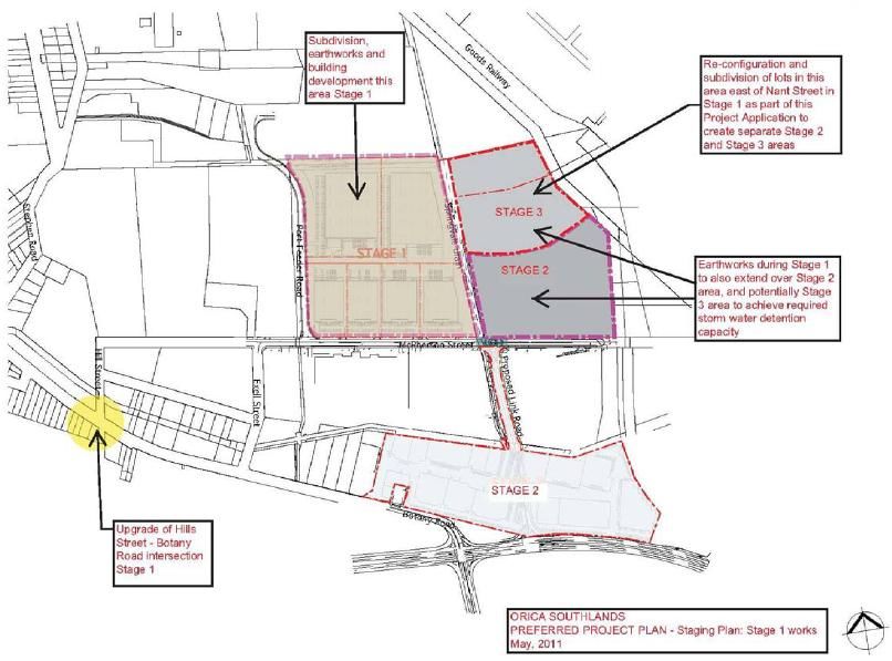
samsa
 _________________________________________________ consulting

                             URS “Southlands Development, Botany, Access Implications Assessment”, 16
                             October 2006
                             URS “Southlands Remediation and Development Project, Environmental
                             Assessment, Project Application (MP 06_0191)”, August 2009

1.2            Report Structure

               The remainder of this report is presented as follows:
                         Chapter 2 describes the proposed project.
                         Chapter 3 provides a review of the traffic and access assessment undertaken for the
                                   project.
                         Chapter 4 details the stakeholder and community issues raised in project
                                   submissions including description of project amendments and a preferred
                                   project plan.
                         Chapter 5 provides conclusions and recommendations to the assessment review.

Orica Southlands Devt_transport               Orica Southlands Remediation & Redevelopment, Banksmeadow
                                                              Transport Assessment Review                 3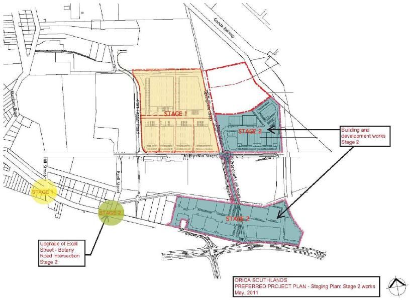
samsa
 _________________________________________________ consulting

2.             Project Description

               Orica‟s Southlands site at Banksmeadow is approximately 18.2 ha in size and is bounded
               by McPherson Street to the south, Port Feeder Road to the west, Sydenham-Botany Goods
               railway line to the east and the Mobil site and Nant Street tank farm to the north – refer to
               Figure 2.1: Project Location following. The Southlands site is located wholly within the City
               Of Botany Bay Council area.

                                                                                SOUTHLANDS
                                                                                   SITE

                                       Figure 2.1: Project Location

               The site is currently vacant except for equipment and infrastructure required by Orica to
               maintain ongoing groundwater remediation. The site is surrounded by mainly industrial and
               warehousing activity with some commercial land uses.
               The Orica Southlands project involves collaborative remediation and redevelopment of the
               site to create a new industrial estate. It is proposed that the site would become a major
               industrial and warehousing estate servicing Port Botany and the wider Sydney Metropolitan
               Area. The original project application comprises the following key components (a
               subsequent Preferred Project Plan is described in Chapter 4 of this document).
                         Establishment of industrial / warehousing development, with a proposed floor area
                         of 79,190 m2 split up as follows:
                             - Stage 1: 47,000 m2 GFA (western half of site)
                             - Stage 2: 16,490 m2 GFA (south-eastern portion of site)
                             - Stage 3: 15,700 m2 GFA (north-eastern portion of site and subject of a

Orica Southlands Devt_transport           Orica Southlands Remediation & Redevelopment, Banksmeadow
                                                          Transport Assessment Review                    4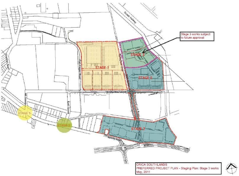
samsa
 _________________________________________________ consulting

                                     future development application)
                             Operations on a 24-hours / 7-days a week basis
                             Associated infrastructure includes:
                                - site access off McPherson Street;
                                - upgrades to the Hill Street and Exell Street intersections at Botany Road in
                                     Stage 1;
                                - new road link to Botany Road in Stage 2 of the development, including
                                     internal reconfiguration of Discovery Cove Estate;
                                - flood mitigation works;
                                - approximately 820 car parking spaces, with allowance for future decked
                                     parking area of 300 spaces if required in future; and
                                - landscape works.
               The proposed site layout and development staging for the original project application is
               shown in Figures 2.2 to 2.4 following.

                 Figure 2.2: Proposed Site Layout (Original Project Application)

Orica Southlands Devt_transport                Orica Southlands Remediation & Redevelopment, Banksmeadow
                                                               Transport Assessment Review                 5
samsa
_________________________________________________ consulting
Figure 2.3: Aerial Perspective of Proposed Site Layout and Link Road
Figure 2.4: Proposed Development Staging (Original Project Application)
Orica Southlands Devt_transport Orica Southlands Remediation & Redevelopment, Banksmeadow
Transport Assessment Review 6samsa
_________________________________________________ consulting
3. Review of Traffic & Access Assessment
In undertaking a review of the traffic and access assessment for the original proposal /
project application, Traffix‟s “Southlands Stages 1 and 2 Project Application, Traffic Impact
Assessment for an Industrial/Warehouse Development at McPherson Street,
Banksmeadow” (dated October 2007) was used as the main document in addition to the
other documents noted in Section 1.1 previously. Subsequent reviews of the later Preferred
Project Plan are included in Chapter 4 of this document.
The EA identifies that the proposed development for the original project application would
increase the number of heavy vehicles on Hill Street, Exell Street and Botany Road to
access the Southlands site. It is noted that Stage 3 of the proposal would be subject to
future approvals, however, for the purposes of the assessing the traffic impacts for the
proposal, traffic generated by Stage 3 was included in the traffic assessment.
3.1 Key Assessment Issues
In carrying out the assessment of transport-related impacts for the proposal, the proponent
was required to address several key areas related to traffic and access, which were
nominated by the DoP‟s Director General. These key areas included the following:
Description of the existing traffic and transport environment.
Details of traffic types and volumes to be generated.
Details of proposed site access to service the development areas, internal roads
and parking.
Predicted impacts on road safety and capacity of the road network, particularly the
surrounding arterial road network and nearby intersections, and consequent need
for any road upgrades or improvement works.
Assessment of any other potential impacts of the project, including any cumulative
impacts, taking into consideration any relevant guidelines, policies, plans and
statutory provisions.
Description of the measures that would be implemented to avoid, minimise,
mitigate and/or offset the impacts of the proposal.
Preliminary design details and timing of any roadworks or other transport related
infrastructure proposed as part of the development.
3.2 Parking & Site Access
Parking provision for the development is proposed as follows:
Stage 1: 440 spaces including accessible parking as per Australian Standards plus
potentially an additional 300 spaces in a decked arrangement
Stage 2: 260 spaces proposed
Stages 1 & 2: 700 spaces proposed plus potentially an additional 300 spaces
The following comments are provided with respect to parking provision:
There is a deficiency in parking provision based on Council‟s DCP parking rate
Orica Southlands Devt_transport Orica Southlands Remediation & Redevelopment, Banksmeadow
Transport Assessment Review 7samsa
_________________________________________________ consulting
(which would require 600 spaces for Stage 1 and 821 spaces for Stages 1 & 2) but
a surplus based on RTA‟s guideline rate (which would require 148 spaces for
Stage 1 and 203 spaces for Stages 1 & 2). Council‟s argument that their higher
DCP parking rate would be more appropriate because the development has the
potential to be subdivided in future creating increased tenancy levels that may be
higher than those on which RTA guideline parking rates are based appears
reasonable. Further justification of parking rates would be useful, eg. comparison
with comparable developments with similar public transport and road network links.
It should be noted that higher parking rates resulting in increased spaces are likely
to result in increased traffic generation by increasing the latent traffic demand, ie.
more available on-site parking would generally attract more car trips. This is why
some public authorities are now capping parking rates or working to „maximum‟
rates rather than „minimum‟ rates. In capping and reducing parking rates,
alternative transport modes need to be readily available (eg. bus services) so that
on-street parking is not used at the expense of residents or other users.
A comment is made in the Traffix report that parking provision could be reviewed
at later development stages if necessary. This approach is considered to be
imprudent and parking provision should be finalised prior to development because
it is often difficult to provide additional parking at later stages and/or retro-fit
parking into site areas. Furthermore, parking provision has a direct affect on traffic
generation, which affects site access and road network upgrades that may have
been provided based on lower parking and hence traffic generation numbers.
No mention was made of the provision of accessible parking spaces.
In determining parking space provision, Table 2 (page 14) in the Traffix report has
incorrectly used an area of 40,000 m2 for warehousing land use rather than the
43,000 m2 used previously in the report.
With respect to site access and internal manoeuvring, the assessment states compliance
with AS 2890.1 and AS 2890.2 for vehicles up to B-double size including swept path
analysis. This is considered to be adequate.
Separation of light and heavy vehicle driveway accesses is not fully provided as mentioned
in the Traffix assessment. There are separate driveway accesses for light vehicle parking
areas directly off McPherson Street, but internal parking areas would be accessed via the
internal access road, which would also be used by heavy vehicles. While this is not ideal,
with appropriate traffic controls, signage and linemarking, this should not present a
significant concern.
3.3 Traffic Generation
The original proposal / project application assessment initially adopted a traffic generation
rate of 15 vehicle trips per developable hectare for warehouse/distribution purposes as had
been adopted by RTA in other similar locations including the Western Sydney Employment
Hub. This resulted in traffic generation of 230 vehicle trips per hour (vtph) during peak travel
periods. An 80:20 peak directional split was assumed, which is considered reasonable.
Subsequently, more detailed traffic generation rates from RTA‟s “Guide to Traffic
Generating Developments” were used to obtain traffic generation from the proposed
development‟s floor area, which would be more absolute. These resulted in a traffic
Orica Southlands Devt_transport Orica Southlands Remediation & Redevelopment, Banksmeadow
Transport Assessment Review 8samsa
_________________________________________________ consulting
generation range between 345 vehicles per hour (vph) to 790 vph. The 345 vph was
incorrectly calculated from the generation rate of 0.5 vtph per 100 m2 floor area for 79,190
m2 of floor area – this should have been 396 vph.
In any case, a traffic generation rate of 465 vph was adopted by the assessment, which it is
assumed was used because it was approximately double the initial vehicle trips per
developable hectare rate. The assessment mentioned that the adopted rate “represents a
worst-case scenario that potentially overstates the expected level of traffic generation”,
which is prudent in determining potential impacts. It also mentions that the adopted rate
may be further conservative (ie. high) if the adjacent rail infrastructure is used as a transport
mode for some end-users. While this is correct, there is no further discussion or
assessment of the potential for rail transport.
The percentage of heavy vehicles within the overall forecast traffic generation was not
provided in the assessment. The heavy vehicle percentage would be significant for a
development such as the one proposed and should be evaluated and used in any modelling
scenarios due to the effects that heavy vehicle movements have on intersection and road
network operations.
Traffic generation should also take into account the number of parking spaces proposed.
Higher parking numbers are likely to result in increased traffic generation by increasing the
latent traffic demand, ie. more available on-site parking would attract more car trips,
particularly if alternative transport modes such as buses and bicycles are not provided. For
the assessment of Stage 1 of the proposed development, the adoption of a traffic
generation of 235 vph was used in conjunction with parking for 442 parking spaces. This
represents only approximately half the number of trips per hour per parking space, which
seems low and would result in an under-utilised parking area for long periods. Similarly, for
the combined Stages 1 and 2, the traffic generation of 465 vph was used in conjunction with
parking for 700 parking spaces.
Heavy vehicle trips should also include nominated heavy vehicle routes to allow for travel
along the major road network and not through local streets, eg. approach via Foreshore
Road, Botany Road, Hill Street, McPherson Street and departure via McPherson Street,
new link road / Exell Street, Botany Road, Foreshore Road.
In describing future 2016 traffic conditions, the Traffix assessment report mentions major
developments in the wider area including Port Botany Expansion, Green Square urban
renewal, Sydney Airport Master Plan and Prince Henry Hospital Redevelopment. These are
estimated to generate an additional 26,700 vph onto the road network and in this context
the proposed Southlands development would only account for less than 2% of this traffic.
This is misleading in that the above traffic would be distributed over a wide area of south-
eastern Sydney, while the Southlands traffic generation would affect a localised area
surrounding the site, which is where its major impacts would occur.
3.4 Road Network and Intersection Analysis
The road network and intersection analysis for the original proposal / project application
was undertaken by URS in a separate network modelling and intersection assessment
report appended to the Traffix report. URS produced network models in both AM and PM
peak periods for the following scenarios:
Existing 2006 conditions (model calibrated to traffic counts)
Orica Southlands Devt_transport Orica Southlands Remediation & Redevelopment, Banksmeadow
Transport Assessment Review 9samsa
_________________________________________________ consulting
2016 base traffic flows without traffic generation from the proposed Southlands
development using existing local road network conditions
2016 traffic flows with Southlands traffic generation and road network Option 1
(McPherson Street roundabout connection via new link road to existing Discovery
Cove Estate roundabout on Botany Road)
2016 traffic flows with Southlands traffic generation and road network Option 2
(McPherson Street connection via new link road through Discovery Cove Estate to
signals on Botany Road east of Foreshore Road – designated as the preferred
option in the assessment report)
2016 traffic flows with Southlands traffic generation and road network Option 3
(McPherson Street extension east over Goods Railway line to signals on
Beauchamp Road)
In addition, a further Option 4 was assessed with intersection analysis only. This option
adopted 2016 traffic flows with Southlands traffic generation using the existing local road
network but with upgrades to Hill Street (separated lanes for left-turn and right-turn
movements from Botany Road) and Exell Street (signals at Botany Road).
The lack of a road network model for Option 4 is not significantly problematic because the
local road network is essentially the same and maintains a „closed‟ road network off Botany
Road via the Hill Street entry and Exell Street exit. However, for consistency, a road
network model used for the other options would be useful to determine if any redistribution
of traffic occurs due to the introduction of a new set of signals on Botany Road, for example.
Option 4 was assessed to essentially show that the new link road would not be required
until Stage 2 of the original proposed Southlands development. However, it should be noted
that for this option, it is unlikely that RTA would approve of the proposed upgrade to the
Exell Street intersection by introducing a new set of traffic signals on Botany Road. The
intersection analysis for 2016 with development traffic using Exell Street sign control
indicates poor intersection performance with significant average delay. Therefore, another
(non-traffic signal) option would need to be developed to show that the Exell Street exit onto
Botany Road is adequate.
Other comments with respect to the original proposal / project application on the road
network and intersection analysis modelling include:
It is understood that the timeframe for the development to be operational is 2011.
This would be for Stage 1 but it is not known when Stage 2 and the associated
new link road would be constructed. The road network modelling undertaken
should assess the road network for a minimum 10-year period including the
proposed link road intersection at Botany Road. In this regard, the 2016 models
provided in the assessment are too short-term (less than five years after
operations start) and should be extended to at least 10 years after Stage 2 and the
new link road are proposed to be operational.
The combined use of Netanal, Scates and Intanal models is considered
appropriate to cover strategic network-wide issues, signal coordination issues and
localised intersection analysis respectively.
Intersection analysis results for the existing road network and traffic conditions
appear to indicate generally better performance than traffic operations observed on
site, eg. level of service (LoS) C and average vehicle delay (AVD) of 38 seconds in
Orica Southlands Devt_transport Orica Southlands Remediation & Redevelopment, Banksmeadow
Transport Assessment Review 10samsa
_________________________________________________ consulting
both AM and PM peak periods for the Botany Road / Foreshore Road intersection.
The URS modelling assessment does not indicate what growth rate was used to
determine background traffic volumes required for the 2016 scenario analyses.
The background traffic growth alone is shown in the URS modelling assessment in
Figures 8 and 9. However, the road network appears to be missing Foreshore
Road in these figures.
Modelling used the 465 vph development traffic generation but adopted a 70:30
peak directional split, ie. 325 vph arriving the morning peak period and 140 vph
departing and the opposite during the afternoon/evening peak period. Although this
is inconsistent with the Traffix assessment report, it is considered to be a
reasonable assumption.
The 2016 base traffic models (background traffic only without Southlands traffic)
for AM and PM peak periods both seem to be missing the Foreshore Road link
from their network diagrams. This is likely to be a printing error because volumes
east of Foreshore Road are significantly higher than those entering or exiting into
Botany Road (west) and Penrhyn Road. Nonetheless, correct network diagrams
are required to assess and compare traffic distribution.
For the preferred Option 2 road network (with new link road onto Botany Road east
of Foreshore Road), the model network diagram shown for the PM peak period is
the Option 1 model network – refer to Figure 15 in URS report. The Option 2 model
network diagram for the PM peak period is required to assess and compare traffic
distribution for that option.
The „sign control‟ results for the Exell Street intersection analysis (Table 22 in URS
report) appear to indicate that the „side road‟ (presumed to be Exell Street) has
average annual daily traffic (AADT) of 24 vehicles, which would be incorrect.
The network modelling for future 2016 scenarios does not seem to consider the
two proposed intersections on Foreshore Road being constructed for the Port
Botany Expansion project. Furthermore, the increases in traffic from Penrhyn Road
onto the Botany Road / Foreshore Road intersection appear to be low considering
the increase in activities associated with the expansion of Port Botany.
There does not seem to have been any consideration of operations at the
McPherson Street development site access point with no intersection analysis at
this location.
3.5 Proposed Road Network Upgrades
In the original proposal / project application, upgrades to the existing road network were
proposed as follows:
Signalisation of Botany Road / Exell Street intersection (during Stage 1)
Formalisation of Botany Road / Hill Street intersection with separation of left and
right-turn in movements (Stage 1)
Replacement of Discovery Cove Estate roundabout (at a later indefinite date)
Additional lane (eastern side) for Botany Road southbound approach to the
Foreshore Road intersection (at a later indefinite date)
Signalisation of existing Discovery Cove Estate left-in / left-out access onto Botany
Orica Southlands Devt_transport Orica Southlands Remediation & Redevelopment, Banksmeadow
Transport Assessment Review 11samsa
_________________________________________________ consulting
Road in readiness for the new link road connection at a later date (prior to Stage 2)
The following comments with respect to the original proposal / project application are
provided with respect to proposed road network upgrades:
For the proposed Hill Street intersection upgrade, there would be a circuitous route
for vehicles wanting to access Greenfield Street from the left-turn off Botany Road
southbound because of the restriction to cross-over movements in Hill Street.
Vehicles would need to travel via Hill Street, McPherson Street, Exell Street and
enter Greenfield Street westbound rather than enter directly eastbound from Hill
Street. Moreover, vehicles would need to turnaround in Greenfield Street to exit via
Exell Street rather than travel around the block again by exiting via Hill Street,
McPherson Street and Exell Street to Botany Road. The assessment has not
adequately addressed whether westbound Greenfield Street vehicles would be
able to turn-around and exit via Exell Street.
The deceleration lane for the left-turn into Hill Street from Botany Road would need
to be sufficiently long and delineated to allow right-turn movements to safely
assume that left-turn movements are not continuing southbound along Botany
Road, thus unnecessarily delaying the right-turn movements into Hill Street.
The proposed four-lane widening of the Botany Road southbound approach to
Foreshore Road appears to encroach on adjacent land outside the existing road
reserve. There is a risk that a larger road upgrade would be required, which would
need to be approved by RTA and affect Foreshore Road / Botany Road / Penrhyn
Road intersection operations.
The Exell Street signalised intersection is located in relative close proximity to the
Foreshore Road / Botany Road / Penrhyn Road intersection. Signal operations
would need to be coordinated with the major intersection to prevent queuing
upstream or downstream of the new intersection. Therefore, operations may not be
optimal for traffic exiting Exell Street. This issue has been raised by RTA, which
stated that signals would not be approved at this location because their modelling
indicated extensive delays and unacceptable queue lengths on Botany Road.
3.6 Alternative Transport
The assessment report mentions the potential for reduced traffic generation due to adjacent
rail infrastructure being available as a transport mode. However, there is no further
feasibility assessment of rail transport and all transport is proposed by road. Moreover,
Council‟s DCP 33 (Banksmeadow Industrial Precinct) requires developments with frontages
onto the Goods Railway line to investigate rail transport options, which the assessment has
not provided.
It is considered that alternative transport options including pedestrian and bicycle facilities
have not been adequately addressed. This includes:
Pedestrian access between the development site and existing bus services along
Botany Road (Sydney Buses Route 309).
Cycleways (on-road and off-road) serving the site and connecting to existing on-
road cycleway along Foreshore Road, west of Botany Road and any proposed
future cycle networks.
Orica Southlands Devt_transport Orica Southlands Remediation & Redevelopment, Banksmeadow
Transport Assessment Review 12samsa
_________________________________________________ consulting
Bicycle parking and „end-of-journey‟ facilities at the proposed development site.
The assessment states that bus services would be improved to the area with the provision
of the proposed new link road. This however, would need to be confirmed with Sydney
Buses or other bus operators and in any case would not occur until Stage 2 of the
development when the new link road is proposed to be constructed.
3.7 Construction Phase Issues
A detailed construction traffic management plan (CTMP) has been proposed for Stage 2
works when Stage 1 is operational and Stage 2 construction activities would coincide with
Stage 1 operations. However, a CTMP would also be required to be prepared and
submitted for approval prior to Stage 1 construction activities proceed. This should include
proposed traffic mitigation and road safety measures as well as nominated heavy vehicle
routes, eg. approach via Foreshore Road, Botany Road, Hill Street, McPherson Street and
departure via McPherson Street, new link road / Exell Street, Botany Road, Foreshore
Road.
Construction truck generation for Stage 1 of the project stated a peak of 100 trucks per day.
However, only the average daily truck generation of 50 to 60 trucks was considered in the
assessment. It is considered that a peak generation would be more appropriate and provide
a conservative („worst case‟) basis to the assessment.
Orica Southlands Devt_transport Orica Southlands Remediation & Redevelopment, Banksmeadow
Transport Assessment Review 13samsa
_________________________________________________ consulting
4. Stakeholder & Community Submissions
4.1 Submissions Received
During the exhibition period for the Project, the DoP received 17 submissions on the
project, including:
8 submissions from public authorities;
3 submissions from special interest groups; and
6 submissions from the neighbouring landowners / general public.
Public Authorities
Submissions came from Sydney Regional Development Advisory Committee (SRDAC),
NSW Roads and Traffic Authority (RTA), City of Botany Bay Council (CoBB), Randwick City
Council (RCC), Australian Rail Track Corporation Ltd (ARTC),Ministry of Transport,
Department of Environment and Climate Change (two separate submissions), South
Eastern Sydney and Illawarra Health Service – Public Health Unit, and Sydney Water. The
following traffic and transport issues were raised:
RTA / SRDAC
- The modelling undertaken was not considered appropriate because of the
timeframe (too short until 2016 – should model until 2026 for minimum 10-year
life for new intersection) and the strategic nature of the modelling (Netanal and
Scates models). A micro-simulation model would be better covering the local
area that redistributes traffic flows and evaluates intersection operations.
- RTA would not approve the proposed link road intersection at Botany Road
unless modelling indicates intersection operations and traffic distribution would
not have detrimental effects on Botany Road and Foreshore Road.
- Model should include a „no right turn‟ from Botany Road into the new link road.
- RTA modelling indicates that traffic signals on Botany Road at Exell Street
would create extensive delays and unacceptable queue lengths on Botany
Road. Therefore, signals would not be approved at this location.
- Left-turn slip lane and right-turn bay into Hill Street off Botany Road would be at
the proposed development‟s expense.
- Traffic generation for the development was underestimated at 465 vehicle trips
per hour – should be 495 vehicle trips per hour based on RTA‟s “Guide to Traffic
Generating Developments”.
- Traffic report mentions the potential for reduced traffic due to alternative rail
transport mode. However, there is no further feasibility assessment of rail
transport and all transport is proposed by road.
RTA raised the following additional transport-related concerns at a meeting with
DoP on Thursday 1 July 2010 (held at RTA Parramatta offices):
- Clarification from DoP on the status of landowners consent for the Link Road (to
service Stages 2 & 3). Council has said that Orica don't have landowners
consent for the proposal.
- Justification from Orica for a right-hand turn out of Exell Street, when Botany
Orica Southlands Devt_transport Orica Southlands Remediation & Redevelopment, Banksmeadow
Transport Assessment Review 14samsa
_________________________________________________ consulting
Road (north) leads to an area with heavy vehicle restrictions.
- Too much for all traffic (ultimate Stages 2 & 3) to go through Exell Street – Stage
1 may be suitable (subject to conditions), but stages 2 & 3 would require a new
access road (new Link Road).
- Location where the Link Road intersects with Foreshore Road may be
problematic due to distance to next intersection / traffic flow. RTA may have to
recommend a restriction such as banning right-hand turn.
- Impact of fly-over proposal from Sydney Ports on Foreshore Road. This would
have serious implications for all proposals in the area, particularly the Link Road
connection.
CoBB
- Botany Road, south-east of Stephen Road, experiences extensive congestion
and queuing in the afternoon peak period (3 to 6 pm) due to Foreshore Road
intersection signal phasing.
- The modelling undertaken should be extended until 2026 for realistic life-span of
new link road and intersection at Botany Road.
- Council‟s DCP 33 (Banksmeadow Industrial Precinct) requires developments
with frontages onto the Goods Railway line to investigate rail transport options,
which the assessment has not provided.
- Alternative transport options including pedestrian and bicycle facilities have not
been adequately assessed.
- No reallocation of lost on-site parking at Discovery Cove Estate due to proposed
link road modifications through the site.
- Adequacy of truck manoeuvring paths along the proposed link road and on-site
including through Discovery Cove Estate has not been suitably addressed, eg.
interaction of semi-trailers with other on-site light vehicle traffic.
- Truck routes need to be nominated:
Approach via Foreshore Road, Botany Road, Hill Street, McPherson Street
Departure via McPherson Street, new link road / Exell Street, Botany Road,
Foreshore Road
- Deficiency in parking provision based on Council‟s DCP rates
Stage 1: 440 proposed but 642 required
Stage 2: 260 proposed and 228 required
Stages 1 & 2: 700 proposed but 870 required
Stage 1 should include the additional 300 decked parking spaces proposed
for the long-term
- Council considers their higher DCP parking rate to be appropriate because the
warehouse development has the potential to be subdivided in future creating
increased tenancy levels that may be higher than those on which RTA guideline
parking rates are based. Future subdivision of the site would not be able to
readily provide increased parking once the development is complete.
RCC
- Would not support a new link road extending east over the rail line along the
McPherson Street alignment and connecting to Beauchamp Road at Perry
Orica Southlands Devt_transport Orica Southlands Remediation & Redevelopment, Banksmeadow
Transport Assessment Review 15samsa
_________________________________________________ consulting
Street, because the development traffic would have direct impacts on RCC road
network.
- Traffic and road safety issues during construction need to be addressed
including the preparation of a detailed CTMP and truck routes to use the major
road network via Botany Road and Foreshore Road.
ARTC
- If an option to extend McPherson Street over the railway line was chosen, ARTC
would require appropriate vertical clearance (7.1 m) and formal application to
ARTC.
- Any future rail sidings / connections into the ARTC network would require formal
application to ARTC.
Ministry of Transport
- Alternative transport modes not addressed adequately in the assessment, eg.
pedestrian and cyclist facilities, public transport (buses). Examples include
pedestrian network to serve existing bus services on Botany Road (eg. Route
309) and cycleways to connect into existing and proposed networks.
- There are opportunities for a mode-shift away from private vehicle (car)
transport but not addressed adequately in the assessment.
- Workplace travel plans should be prepared covering issues such as:
adequate bicycle storage and „end-of-journey‟ cyclist facilities;
management of parking including reduction in parking space provision to
lower RTA rates to encourage use of public transport and cycling;
employee „car share‟ schemes; and
preparation of Travel Access Guides (TAGs) to inform staff and site visitors
of transport options.
Special Interest Groups
Submissions came from Sydney Ports Corporation, Botany Environment Watch and
Concerned Citizens Association Rockdale 3rd Ward. The following traffic and transport
issues were raised:
Sydney Ports Corporation
- New link road may adversely impact on the operations of the key port access
intersection of Foreshore Road and Penrhyn Road, including the proposed
grade-separated road access at Penrhyn Road as part of the Port Botany
Expansion project.
- Intersections have been analysed in isolation and the assessment does not
consider two proposed intersections on Foreshore Road being constructed for
the Port Botany Expansion project as well as Botany Road / Beauchamp Road
intersection. Coordinated analysis is required of all intersections.
- Further justification is required of traffic generation and parking rates – would be
more representative to use comparable developments rather than RTA rates.
- Need to distinguish between light and heavy vehicle traffic generation.
- Modelling analysis needs to be extended to at least 2021 for longer term
assessment.
Orica Southlands Devt_transport Orica Southlands Remediation & Redevelopment, Banksmeadow
Transport Assessment Review 16samsa
_________________________________________________ consulting
- Traffic volumes adopted for 2016 scenario analysis appear to be low with limited
background traffic growth.
- The proposed four-lane widening of the Botany Road southbound approach to
Foreshore Road would not be readily achievable within the existing road
reserve, indicating a larger road upgrade would be required.
Botany Environment Watch
- New roads would result in increased traffic, which would impact on nearby
residential areas.
- Compliance with NSW DECC‟s industrial noise policy would be required during
construction and operations.
Concerned Citizens Association Rockdale 3rd Ward
- Botany Road is currently congested (“a nightmare”) and the site is served by a
poor road network.
- The road network in the surrounding area needs to be assessed as a whole.
Traffic signals proposed along Botany Road would be very close together
increasing congestion, which is currently significant at the Botany Road /
Foreshore Road intersection.
Neighbouring Landowners / General Public
A number of issues were raised by neighbouring landowners and the general public
including Gazal Corporation Ltd, ING Industrial Fund, Solvay Interox Pty Ltd, Hynlong Pty
Ltd, Lynda Newnam and Jim Towart. The following traffic and transport issues were raised:
Submission by Johnson Winter & Slattery Lawyers on behalf of Gazal Corporation
Ltd (neighbouring property on southern side of McPherson Street). The submission
included a „Review of Traffic Reports‟ by ML Traffic Engineers. The main issue
raised was that the proposed link road should be provided for Stage 1 of the
development rather than delayed until Stage 2. Other issues raised with respect to
the transport assessment were:
- Strategic traffic forecasts until 2016 would not satisfy long-term projections;
- Assumptions were made in the modelling that upgrades to Hill and Exell Streets
had been completed;
- Assessment states that bus services would be improved to the area with the
provision of the proposed link road, however this would not be evident until
Stage 2 of the development;
- Background traffic in modelling did not take into account two new major
developments, ie. Toll development on southern side of McPherson Street and
12 warehouse units at the corner of McPherson and Exell Streets;
- Traffic generation and travel demand is too low based on the high car parking
provision; and
- Lack of intersection modelling at the McPherson Street access point.
Submission by Urbis on behalf of ING Industrial Fund who own several properties
in the vicinity of the Orica site. The main issue raised was that the proposed link
road should not be delayed until Stage 2 of the development. Moreover, existing
traffic congestion problems at Hill Street, Exell Street, the Discovery Cove Estate
Orica Southlands Devt_transport Orica Southlands Remediation & Redevelopment, Banksmeadow
Transport Assessment Review 17samsa
_________________________________________________ consulting
roundabout and Botany Road queuing back from Foreshore Road would be
exacerbated by the Stage 1 development without the proposed link road.
Solvay Interox Pty Ltd (neighbouring property on western side of Orica site) noted
existing congestion on the local road network of McPherson, Hill and Exell Streets,
as well as extensive congestion on Botany Road would be exacerbated during
Stage 1 of the proposed development without the provision of the new link road.
Furthermore, the proposed road upgrades for Stage 1 would have minimal affect
on existing congestion issues.
Lynda Newnam “Objection to Orica Southlands Project Application 06/0191: Part
3a Development”. The submission raised the following transport-related issues:
- Improving existing traffic via upgrades to Hill and Exell Streets would not
compensate for the traffic generation from the proposed development.
- Warehousing development at this site would impact on Port Botany‟s container
transport flows.
- From a transport and land-use viewpoint, these type of warehouse
developments should be located in Sydney‟s population centre (west of
Parramatta) where intermodal terminals are planned.
4.2 Orica Response to Submissions
Orica prepared a response to submissions received as follows: Orica Australia Pty Ltd
“Southlands Remediation and Development Project: Response to Submissions on the
Environmental Assessment & Preferred Project Plan, Final Issue to DoP (Rev.2)”,
November 2010.
With respect to transport issues, the amended (preferred) project plans include the following
modified characteristics:
Essentially the same number of parking spaces based on a slightly smaller
development area (46,500 m2 against the previous 47,000 m2) – 437 parking
spaces against the previous 440 spaces. No mention was made of accessible
parking spaces or bicycle parking facilities.
Essentially the same traffic generation based on a similar development area –
46,500 m2 against the previous 47,000 m2.
The proposed interim improvements for Stage 1 remain unchanged and include
the installation of traffic signals at the intersection of Exell Street with Botany Road
and the provision of improved channelisation at the intersection of Hill Street with
Botany Road. It is noted that the provision of traffic signal control at the
intersection of Exell Street with Botany Road is proposed for the Stage 1
development only, with the intersection‟s long-term operation to be assessed later
as required by the RTA in relation to the Link Road that is proposed in Stage 2.
Change for direct vehicular access onto Coal Pier Road, which serves
Warehouses 5 and 6. Warehouses 1 to 4 inclusive retain direct access onto
McPherson Street.
It is considered these minor changes are reasonable and satisfactory.
Orica Southlands Devt_transport Orica Southlands Remediation & Redevelopment, Banksmeadow
Transport Assessment Review 18samsa
_________________________________________________ consulting
The responses relating to traffic and transport were largely based on an additional traffic
review prepared by Traffix for Orica (dated 30 May 2010 and updated 7 December 2010
based on amended project plans dated 8 November 2010) included as Appendix 2 to
Orica‟s „Response to Submissions‟ report. The responses are summarised as follows:
Parking rates and provision are above RTA‟s “Guide to Traffic Generating
Developments” rates but below Council‟s parking rates. Providing the higher
Council parking provision would undermine the State Government policy of
pursuing travel by promoting alternate (non-car) travel modes. No latent parking
demand is anticipated.
Shift overlaps for the development would occur outside peak background traffic
periods and thus an increased level of parking would not result in a commensurate
increase in peak period traffic generation.
The percentage of heavy vehicles used in the modelling was 20% and this was
considered reasonable for the peak background travel periods when the
predominant traffic movements are associated with employee arrivals and
departures.
The peak parking demand occurs at shift change-over time which does not
coincide with the on-street peak background travel periods. The peak period traffic
generation is therefore independent of peak period parking demands and hence,
there is no need to penalise the application by the adoption of higher trip rates due
to parking provision.
Concern that the road improvements being required to accommodate this
development are largely due to other development in the area, including general
traffic growth over a 10 year period. Hence, while future modelling can be
undertaken, it should not be assumed that the improvement works that are
identified are wholly the responsibility of the applicant.
The proposed interim improvements (Exell Street signals and Hill Street
channelisation) are intended to facilitate only the Stage 1 development and will be
temporary. All matters raised by the RTA have been addressed. The need for the
Exell Street signals to remain will be further assessed as part of modelling in
relation to the Stage 2 development. Note that a subsequent detailed concept was
developed for the Exell Street signals (dated 17 May 2010) to the satisfaction of
RTA.
Growth rates and land use development assumptions were agreed with the RTA
as part of the modelling process and these vary for individual routes.
The need to assess alternate travel modes would be dealt with through the
preparation of a Transport Access Guide (TAG), which can be conditioned. The
benefits of a TAG are however potentially diminished by the provision of any
parking above the RTA requirements. The applicant prefers that parking is
suppressed slightly (or even more), with alternate travel supported by a TAG.
Construction issues are acknowledged by the applicant and will need to be the
subject of a detailed Construction Traffic Management Plan, which can be
conditioned.
Micro-simulation modelling to be undertaken by the applicant post-Stage 1 would
address Sydney Ports and other stakeholder concerns.
Orica Southlands Devt_transport Orica Southlands Remediation & Redevelopment, Banksmeadow
Transport Assessment Review 19samsa
_________________________________________________ consulting
The proposed Link Road needs to be seen in the context where it provides a
strategic road solution that benefits all landowners and is not required solely to
support the subject application. It does not have a nexus solely with the Stage 1
development and even when provided in Stage 2, there are cost sharing issues
that will need to be addressed including offsets to Section 94 contributions.
Pedestrian and cyclist facilities are proposed around the perimeter of the site and
access into the site.
Site manoeuvring, particularly for longer heavy vehicles (up to B-double size),
would be achieved with full compliance to AS 2890.1 and AS 2890.2, in response
to a condition of consent.
Stage 2 works encompass the Discovery Cove development, which forms a
necessary element of the delivery of the proposed Link Road in Stage 2.
The main change made for the purpose of the Preferred Project Plan relates to the
proposal to provide direct vehicular access onto Coal Pier Road to serve
Warehouses 5 and 6. This achieves a more satisfactory dispersal of trips onto the
road network. Warehouses 1 to 4 would retain direct access onto McPherson
Street.
This review considers the above responses were reasonable and reliant on RTA agreement
of major road operations along Botany Road and Foreshore Road.
4.3 Further Consultations
Additional meetings were held with stakeholders / agencies and Orica / Traffix (Orica‟s
traffic consultants) to discuss traffic and transportation issues subsequent to community
submissions and Orica‟s response to submissions.
A meeting was held with CoBB Council on Friday 18 March 2011 to discuss their views and
outstanding issues (following on from their response letter, dated 18 February 2011, to
Orica‟s additional information). The following pertinent traffic and transport issues were
raised or reiterated:
The traffic modelling and traffic flow predictions should be re-assessed based on
the opening of the Hale Street extension, which should have reduced traffic flows
(particularly heavy vehicle traffic) along the southern end of Botany Road at
Foreshore Road. Council stated that the Hale Street Extension report would be
made available to Orica to obtain traffic flow counts on Botany Road and that
further traffic volumes could be obtained from RTA‟s TCS data at intersections
such as Botany Road / Foreshore Road, Hale Street / Foreshore Road.
No intersection analysis has been done for Botany Road / Foreshore Road.
Council considered that the adoption of a 20% heavy vehicle proportion as being
too low and not indicative of peak hour traffic generation from the development.
Orica‟s view was that this proportion was reasonable during peak periods when the
majority of traffic would be employee movements. This review also considers that
a 20% heavy vehicle proportion is reasonable during background traffic peak
periods.
Council reiterated its concerns that the Link Road for Stage 2 has numerous
issues that affect its feasibility including land ownership along the proposed road
Orica Southlands Devt_transport Orica Southlands Remediation & Redevelopment, Banksmeadow
Transport Assessment Review 20samsa
_________________________________________________ consulting
corridor, flooding issues and RTA agreement to the Link Road intersection onto
Botany Road.
A meeting was held with Orica on Tuesday 22 March 2011 to discuss their views and
progress in addressing issues raised during submissions. The following pertinent traffic and
transport issues were discussed:
Clarification was to be sought on whether the Hale Street extension had been
included as part of the road network modelling undertaken as part of the transport
assessment. Subsequent discussion and advice from the proponent revealed that
the Hale Street extension had not been included as part of modelling for the
transport assessment. The Hale Street extension would have the effect of reducing
traffic volumes along Botany Road in the vicinity of Exell and Hill Streets. This
would improve operations at these intersections and thus the assessment that has
been undertaken by Orica is conservative, ie. higher traffic volumes were used.
Further detailed design development including road network modelling (micro-
simulation analysis) would be required for any post-Stage 1 development.
4.4 Preferred Project Plan
Orica provided a response to the previous issues raised in the form of a “Preferred Project
Plan: Updated and Consolidated Information Package (Rev 6)”, May 2011 and
subsequently “Preferred Project Plan: Updated and Consolidated Information Package (Rev
7)”, June 2011. As part of this Preferred Project Plan, Traffix provided specialist traffic
assessment in a letter report dated 14 April 2011 and a subsequent (and similar) letter
report dated 6 June 2011 (for the respective Preferred Project Plans).
The Preferred Project Plan (PPP) maintains a three-stage development for the project, the
scope of which has not changed since the original submission – see Figures 4.1 to 4.3
below. The Stage 1 earthworks component extends into part of the Stage 2 area and Stage
3 areas.
The PPP confirmed that no building development is proposed for the Stage 3 area in this
Project Application. However, the application does still propose to re-configure and sub-
divide the area east of Nant Street to define Stage 2 and Stage 3 areas, including 2 lots in
the Stage 3 area in order to add a further easement to facilitate future possible remediation.
Updates to the project originally submitted for application are:
Revised traffic layouts at the intersections of Botany Road with both Hills and Exell
Streets, due to revised traffic arrangements in the vicinity of the site subsequent to
the initial submission
Flood modelling to confirm the Stage 1 area of earthworks will be above nominated
flood levels with freeboard
Source of fill for the Stage 1 earthworks utilises material being treated on another
Orica site in the vicinity of Southlands, which has received in principle support from
the Site Auditor and Office of Environment and Heritage.
The Statement of Commitments from Orica for the project was confirmed in the latest
submission.
Orica Southlands Devt_transport Orica Southlands Remediation & Redevelopment, Banksmeadow
Transport Assessment Review 21You can also read