Release Guide WebGIS 2022 - Hexagon Portal
←
→
Page content transcription
If your browser does not render page correctly, please read the page content below
Release Guide

Release Guide
WebGIS 2022

Version 16.7
21 October 2021

Contents
About This Release .................................................................................................................... 5

GeoMedia WebMap .................................................................................................................... 5

Geospatial Portal ....................................................................................................................... 5

Geospatial SDI............................................................................................................................ 5

New Technology ........................................................................................................................ 6
   GeoMedia WebMap .................................................................................................................. 6
      INSPIRE-Ready Services and Enhanced Metadata Editor .................................................... 6
      OGC WFS 2.0 Conformance ................................................................................................. 6
   GeoMedia WebMap Mobile and Mobile Publisher .................................................................... 7
      GeoMedia WebMap Publisher Portal Redesigned/UX Improvements ................................... 7
      Instructions Note for Work (with Markdown) in GeoMedia WebMap Mobile .......................... 9
      Easy Configuration of Searchables ..................................................................................... 10
      Easy Zones Application ....................................................................................................... 11
      Tasks and Works Lifecycle Monitoring ................................................................................ 12
      Snapping in Mobile App ...................................................................................................... 14
      Generate ID for Related Features ....................................................................................... 15
      GPS Data Storage in the Added Features .......................................................................... 16
      Enhanced Display of GPS Location .................................................................................... 17
      Localized GeoMedia WebMap Mobile app .......................................................................... 18
      GeoMedia WebMap Mobile App as Consumer Portal Client ............................................... 19
      Quick Configuration Access with QR Code Scanning ......................................................... 20
      Dashboard View .................................................................................................................. 21
      Geocoding Configuration for the Dashboard Feature .......................................................... 22
      Integration with Google Services ......................................................................................... 23
      Google Base Map for GeoMedia WebMap Mobile .............................................................. 24
      Enhanced GeoPackage Creation – Zoom Level and Quality for Raster .............................. 25
      Better Control of the Offline Data Synchronization Process for Users of the Mobile App. ... 26
      Geometry Limitation Notification for Users .......................................................................... 27
      Address History for GeoMedia WebMap Mobile Start Screen ............................................. 28
      Display Feature Class Name in Feature Info Header of GeoMedia WebMap Mobile. ......... 29
      Enhanced Offline Mode ....................................................................................................... 30

21 October 2021                                                                                                                           2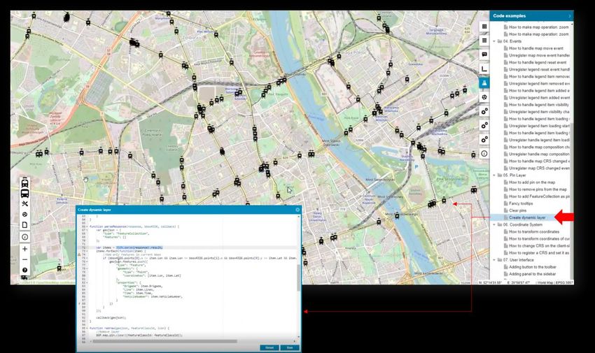
Auto-Configured Primary Key .............................................................................................. 32
   Auto-fill Values for Different Data Ttypes............................................................................. 33
   Default Values ..................................................................................................................... 34
   Enhanced Display of Media Files ........................................................................................ 35
   Remote Server Connection to the Mobile Backend ............................................................. 36
   Enabled Multiple Connections (Handling Several Sources) ................................................ 37
   Handle Multiple Map Windows and Assign Works with a Map Window ............................... 38
   Use Map Window Bounding Box (BBOX) as a Default ........................................................ 39
   Quick Start Guides in Mobile Publisher ............................................................................... 40
   Picture Style Support for the Point Feature Class ............................................................... 41
   Honoring WFS/WMS Legend Entries’ Locatability in GeoMedia WebMap Mobile ............... 42
   New Base Maps (Here Maps/Bing Maps/Google Maps) ..................................................... 43
   Display of GPS Accuracy in GeoMedia WebMap Mobile App ............................................. 44
 Geospatial Portal and Consumer Portal ................................................................................. 45
   Redesigned and Refreshed Consumer Portal UI ................................................................ 45
   Smart Optimalization of Consumer Portal Layout ................................................................ 46
   New Map Composition Switcher.......................................................................................... 47
   Improved Measurements UI in Consumer ........................................................................... 48
   Share Map .......................................................................................................................... 49
   LUWS Search Configuration for Consumer Portal .............................................................. 50
   Search for Coordinates in Consumer Portal ........................................................................ 51
   Base Maps in Consumer Portal ........................................................................................... 52
   Integration of Google Maps and Consumer Portal .............................................................. 53
   Disable Unavailable Elements (Search, Go to My Location) ............................................... 55
   New Display Settings for Consumer Portal and Improved Legend Entry Behavior .............. 56
   Preserve Legend Settings Between Map Composition Switches ........................................ 58
   Consistent Mechanism of Scale Bounds Handling for WMS, WMTS, and WMPS............... 58
   Allow Display of Long Layer Names in Consumer Portal .................................................... 59
   High Contrast Mode and Font Size Change (WAI Design) .................................................. 60
   Easier Registration of Google Maps API key for Portals ..................................................... 61
   Auto Adaptation of the Portal Layout to RTL Languages ..................................................... 62
   New Print Engine Support in Geospatial Portal ................................................................... 63
   Ability to Connect to Secured WFSG Services in Geospatial Portal .................................... 64

21 October 2021                                                                                                                         3
Improved UX for Switching Map Variants in Geospatial Portal Layouts .............................. 65
Remove all Connections and Clear Workspace with One Command in Geospatial Portal .. 66
Using Consumer Portal SDK: Dynamically Refreshed Content ........................................... 67
Geospatial SDI ....................................................................................................................... 68
OGC WFS and WCS 2.0 Façade Conformance .................................................................. 68
INSPIRE-Ready and Enhanced Metadata Editor ................................................................ 68
Administration Console: GeoMedia WebMap, Geospatial Portal, Geospatial SDI .................. 69
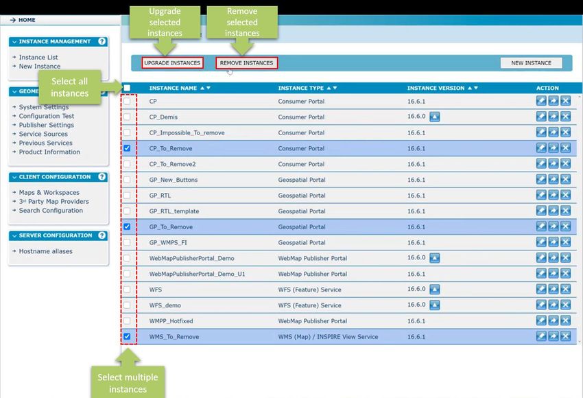
Manage Multiple Instances with Administration Console ..................................................... 69
System Requirements ............................................................................................................. 70
GeoMedia WebMap ................................................................................................................ 70
Geospatial Portal .................................................................................................................... 73
Geospatial SDI ....................................................................................................................... 75
Issues Resolved ....................................................................................................................... 77
Geospatial Server 2022 .......................................................................................................... 77
GeoMedia WebMap, Geospatial SDI, Geospatial Portal ..................................................... 77
About Hexagon ........................................................................................................................ 84
21 October 2021 4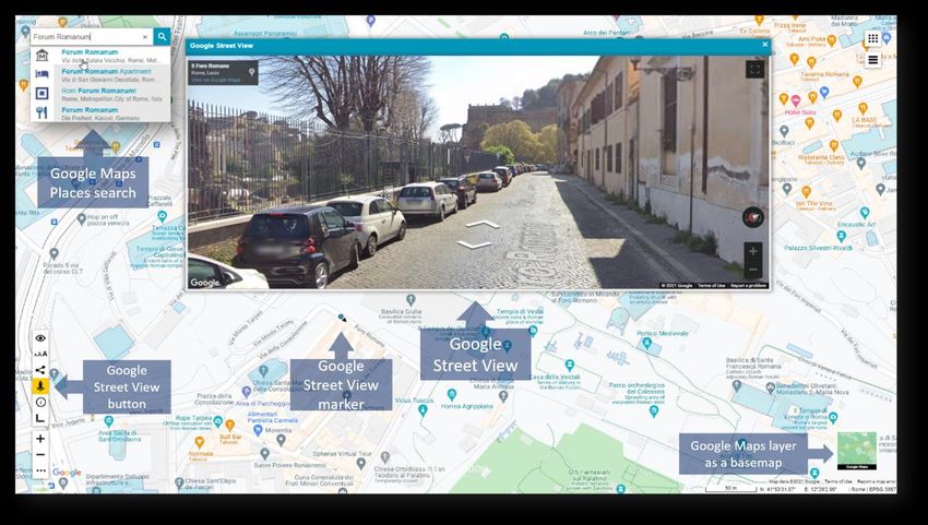
About This Release
This document describes the enhancements for WebGIS 2022 products, including GeoMedia WebMap 2022,
Geospatial Portal 2022, and Geospatial SDI 2022.

This release includes both enhancements and fixes. For information on enhancements, see the New
Technology section. For information on fixes that were made to the WebGIS products for this release, see the
Issues Resolved section.

This document is only an overview and does not provide all the details about the product's capabilities. See the
online help and other documents provided with the WebGIS products for more information.

GeoMedia WebMap
GeoMedia WebMap supports a broad range of customers that require visualization and examination of
geographic data on the web. From easily creating standards-compliant web services to providing sophisticated
visualization and analysis within interactive web mapping applications, GeoMedia WebMap builds powerful
solutions for sharing your organization’s rich geospatial data.

Geospatial Portal
Geospatial Portal is a fully featured, configurable, and customizable thin client application that can be used for
finding, viewing, querying, analyzing, and consuming geospatial data published by Hexagon products and/or
other standards-based web services. The portal can be accessed by multiple users via web browsers, as it is
installed and configured on a web application server.

Geospatial SDI
Geospatial SDI is an interoperable and scalable component of spatial data infrastructure for cataloging and
delivering enterprise geospatial data over the web. It is designed for data providers who need to manage and
serve secure or licensed information using standards-based web services. It offers powerful tools for controlled
access to standards-compliant services and data published by those services, as well as tools for monitoring
and reporting service performance. The product adheres to Open Geospatial Consortium (OGC ®), INSPIRE,
and International Standards Organization (ISO) standards for web services and metadata compliance.
Geospatial SDI can easily extend solutions based on GeoMedia® WebMap, ERDAS® APOLLO, or any other
vendor’s OGC-compliant product to assure the full set of services required for implementation of custom
secure Spatial Data Infrastructure (SDI).

21 October 2021                                                                                                  5
New Technology
GeoMedia WebMap

INSPIRE-Ready Services and Enhanced Metadata Editor
GeoMedia WebMap services have been adjusted to meet the most recent INSPIRE Directive technical
specifications. The INSPIRE technical guidance for view services, download services, discovery services, and
coordinate transformation services were followed and implemented.

OGC WFS 2.0 Conformance
Web Feature Service delivered with GeoMedia WebMap follows the OGC 2.0 International Standard. The
OpenGIS Web Feature Service 2.0 Interface Standard (also ISO 19142) has been implemented for Simple
WFS, Basic WFS, Spatial Filter, and Transactional WFS conformance classes.

21 October 2021                                                                                            6
GeoMedia WebMap Mobile and Mobile Publisher

GeoMedia WebMap Publisher Portal Redesigned/UX Improvements
GeoMedia WebMap Mobile Publisher has been redesigned to make the creation and management of mobile
configurations even more intuitive and the entire Work management process more organized.

Most changes concern the New/Edit Work window where the administrator mainly creates and manages
privileges to data and application components for users. It is also here that he monitors and manages the Work
lifecycle. On the left side of the window are now grouped general options such as Work name, user
assignment, Dashboard enablement, and Offline configuration mode. The completely new option here is
Type. This option allows you to specify whether a given Work is of the task type (new) or general, as it was
before 16.7 (the general Works do not support Work life cycle management).

The Description option is also new in the New/Edit Works dialog. It gives administrators the ability to turn on
or off the display of Work description in the app. The Work description presented to users (with or without a to-
do list) can be prepared on the new Description tab.

There are also two new tabs in the New/Edit Work dialog: Map Content and Description. The already
mentioned Description tab is used to prepare the Work description, which is a new feature of release 16.7.

The Map Contents tab contains all the (well-known) controls necessary to prepare the configuration, which is
closely related to the GeoMedia Desktop map window on which the configuration is built. It includes base
maps, zones, a list of features and their attributes available to users, and more setting options (e.g.,
searchable).

21 October 2021                                                                                                 7
Improvements have also been made to the Works dialog. The new Filter panel in the Works list can be used
to categorize and sort Works by Work name (or its part), Work status, or User assigned. Moreover, now you
can:

    •   Select multiple items in the grid (all, selected, one, none) by using the Shift or Ctrl key.

    •   Add new Work to the list and open its properties dialog with one (button) click.

    •   Remove Users and Works in bulk.

Protection against the accidental deletion of a User or Work has been introduced, so the operation must
always be confirmed.

21 October 2021                                                                                             8
Instructions Note for Work (with Markdown) in GeoMedia WebMap Mobile
The administrator can write a short description of the Work and prepare the task list to be displayed in the app.
The description and the to-do list are presented to the user when he starts the Work. The user, working with
the mobile app, can view the description and checklist later at any time to simply make sure that his job is done
as planned. This improves the communication between the fieldworker and dispatcher.

In GeoMedia WebMap Mobile Publisher, the new Description tab was introduced in the New/Edit Work
dialog where the administrator can prepare the description and/or list of tasks. The description is saved with
the Work definition and can be disabled/enabled for the user at any time by switching the Description option
on/off. The description text can be formatted by using the syntax of simple, easy-to-use, and popular
Markdown language.

Now mobile app users will always know what to do in the field, even when the internet connection is lost.

21 October 2021                                                                                                  9
Easy Configuration of Searchables
Users of the GeoMedia WebMap Mobile app can easily and quickly search for objects from defined data
sources. The administrator decides and defines which feature class objects are searchable. Now the
configuration process is quick and easy without the need for manual editing of the JSON file with complicated
structure.

For each searchable feature class, it is possible to define search attributes and display the name (attribute) for
the search results. The administrator simply selects the legend entries and attributes by using the checkboxes
in the New/Edit Work dialog. Finally, the searchable configuration is validated on the fly when the work is being
saved.

21 October 2021                                                                                                10
Easy Zones Application
Zones used in the current Work configuration are listed in the Zone field. Adding a zone to the Work definition
is intuitive: all the administrator needs to do is to click the Select button and choose the zones from the list. It
is possible to sort zones in ascending and descending order and filter zones by name or part of the name to
find the required zone quickly. If no zone is defined in the database, the message to the user is displayed in
the Zones field. This little enhancement in the New/Edit Work dialog of Mobile Publisher makes it easier to
find and select the zone while preparing the configuration.

21 October 2021                                                                                                   11
Tasks and Works Lifecycle Monitoring
Especially for customers working with mobile technologies from Hexagon, we addressed a new feature – Work
statuses. Work statuses is a feature of GeoMedia WebMap Mobile that helps trace the Work progress. By
tracking the statuses, the administrator easily receives information about which Works have not been started
yet, which are completed and archived, and which have been updated or rejected.
The new filter panel above the Works list in Mobile Publisher allows filtering the tasks as needed.
Administrators can filter the items by name, assigned user, or by status. The filter criteria can be freely
combined (e.g., it is possible to display finished tasks assigned to a particular user and containing a part of the
Work name). This function, especially in the case of large organizations with many field inspectors and a big
amount of fieldwork, will make it easier to find a specific Work and then manage and monitor the Work
progress.
Work statuses are also displayed in the mobile app so the field inspector can see the status of Work assigned
to him. The preview of the status of Work defined in the system is displayed in the Works window, in the
Status column. Each change of Work status made by the inspector or the administrator (e.g., when the
administrator rejects the Work due to detected issues) is immediately reflected in the app so the inspector can
react faster and more efficiently.
The Work lifecycle:

21 October 2021                                                                                                 12
21 October 2021 13
Snapping in Mobile App
To accelerate the productivity and quality of GIS data acquired with the mobile app, snapping (when editing
objects geometry) has been implemented. The snapping feature in the GeoMedia WebMap Mobile app allows
you to edit the feature geometries that connect to other features quicker and with more precision and accuracy.
Now it is much easier to position a geometry in relation to the other features. Snapping significantly reduces
the risk of making mistakes such as overlapping polygons, spaces between polygons, and overlapping lines,
making edits quicker.
Snapping works with all types of geometries supported by the mobile app and is active while editing existing
features and adding new ones. The vertex of the edited geometry can be snapped to vertices of other
geometry and to any point, line, or boundary of area features. The snapping feature is enabled by default but
can be turned off by users if needed.

21 October 2021                                                                                             14
Generate ID for Related Features
By using the Autofill feature, it is possible to generate a unique identifier (GUID) for a feature. The unique
identifier is generated and inserted into the feature attribute automatically after creating and editing a feature.
The unique identifier changes with every feature change (e.g., when some attribute values are updated). This
smart feature can be helpful to analyze data and actions made by users and easily track relations between
features. It works in both configuration modes, online and offline.

21 October 2021                                                                                                  15
GPS Data Storage in the Added Features
The Autofill feature has been extended with the possibility of getting and storing the current GPS data in the
attribute of an added or edited object. You can get and store:

    •   Current GPS location

    •   Current GPS accuracy

    •   Current longitude and latitude.

The device’s GPS data is stored in Text and Double type attributes. Attribute values are filled automatically
when an object is added. Editing an object makes the attribute values update automatically. This autofill
feature improvement for 2022 allows automatic collection of feature location so data administrators and
managers can monitor and control feature localization.

21 October 2021                                                                                                 16
Enhanced Display of GPS Location The Locate Me button (when touched) in the Mobile app acquires and shows the user location. The location marker is displayed on the map temporarily as the default behavior. Starting with the 2022 release, every mobile app user can make the location marker always display. Additionally, the current map scale and zoom level are preserved when the user clicks Locate Me. Changing the behavior for the displayed location marker is simple — just go to the GeoMedia WebMap Mobile app settings screen and toggle the new Keep my location marker option. The location marker follows the user’s device localization when the tracking mode is enabled. 21 October 2021 17
Localized GeoMedia WebMap Mobile app
The WebGIS family of products are multilingual, with options for a variety of languages out of the box.
Continuing to enhance its rich set of languages, the new GeoMedia WebMap Mobile app, which is an integral
part of GeoMedia WebMap, is also localized. The GeoMedia WebMap Mobile app was translated to be
available in Arabic, Catalan, Chinese, Czech, French, Hindi, Polish, Portuguese, Romanian, and Spanish. The
GeoMedia WebMap Mobile app detects the default language on the user’s mobile device and starts
automatically in this language if available. Otherwise, it is run in English. With this feature of the Mobile app,
you can reach more customers and users around the world and easily adapt the product to various languages
and cultures.

21 October 2021                                                                                                18
GeoMedia WebMap Mobile App as Consumer Portal Client
The GeoMedia WebMap Mobile application can act as a client for Consumer Portal layout. It means that users
can connect to Consumer Portal instances in the field with ease and use a GeoMedia Mobile app to consume
Consumer Portal GIS data. This approach makes access to your GIS data easier and faster than running the
Consumer Portal in a standard web browser on a mobile device. It is important to mention that no additional
step or configuration is required to run the Consumer Portal in the app. All the user needs to do is provide the
Consumer URL in the Configuration field or scan a QR code.

21 October 2021                                                                                              19
Quick Configuration Access with QR Code Scanning
To run the GeoMedia WebMap Mobile app, the user must provide the configuration URL. In some situations,
especially when working in the field, it can be more convenient for the user to scan a QR code with the
configuration address instead of typing it directly into the app control. Typing, particularly a long configuration
address, is prone to errors; therefore, to speed up and facilitate the loading of configurations in the mobile app,
the possibility to scan QR codes with encoded configuration URLs was introduced.

Tapping the QR code icon opens the default camera app. Once the user scans the QR code, the proper
configuration URL appears in the address field. Mobile users have the freedom to choose entering the address
manually or using a QR code scanner.

21 October 2021                                                                                                 20
Dashboard View
A completely new feature is the Dashboard view in the mobile application. The Dashboard allows displaying a
list of objects for inspection that are available within mobile configuration. This feature helps locate the objects
to be inspected. The Dashboard is retractable and easy to use and can be accessed at any time.

Within the objects listed in the Dashboard, the object type (e.g., tram stop, water meter) and the distance from
the user’s current location are provided. The distance displayed is updated on the fly when user moves in the
field. The distance is displayed in units of actual settings (metric/imperial). Optionally, when configured by an
administrator, the object addresses can be shown.
Moreover, the Dashboard allows users to plan a route to the selected object with one click. For each object,
there is a button that launches the default navigation application on user’s mobile device, which maps the route
to the selected feature.

Users can filter the objects displayed on the panel. Available filtering options are based on feature class name.
By using general filtering options, you can display either all features (which is the default setting), none, or
editable only. The toggle buttons for each feature class change accordingly to an applied filter setting. You can
individually adjust the filter using the toggle button for each feature class instead of using the general filter
buttons.

The new Dashboard feature can be enabled or disabled by an administrator. This operation can be performed
with one click in the GeoMedia WebMap Publisher.

21 October 2021                                                                                                   21
Geocoding Configuration for the Dashboard Feature
Along with the Dashboard, GeoMedia WebMap offers the possibility for the administrator to define geocoding
addresses that are displayed in the mobile app Dashboard. The Mobile Publisher console has been expanded
with new controls that allow administrators to define an external API for address geocoding. Defined APIs are
used by WebMap to display addresses on the Dashboard if such a function has been defined. Currently, you
can define OpenCage and Google services, but with subsequent updates, more geocoders may be introduced
in the future.

21 October 2021                                                                                           22
Integration with Google Services
A nice new feature in GeoMedia WebMap Mobile is the integration with Google services. Google Maps layers
can be displayed in the Mobile application. Users can turn the Google Maps layer off and on, change the layer
transparency, and choose a type of Google Maps. All this can be done in the app by using standard layer
control.

The integration also includes object search functionality. Using Google Search within GeoMedia WebMap
Mobile is available. The search results in the GeoMedia WebMap Mobile app are the same as in the native
Google Maps app. Pins show the search result, and Feature details can be displayed in the GeoMedia
WebMap Mobile Feature Info dialog.

Google search results can be displayed only if the Google Maps layer is enabled.

21 October 2021                                                                                            23
Google Base Map for GeoMedia WebMap Mobile
As mentioned above, Google services have been integrated with GeoMedia WebMap Mobile. It also means
that Google Maps layers can be configured as a base map for a GeoMedia WebMap Mobile application. The
base map pull-down list in Mobile Publisher has been extended with a Google Maps entry. All additional
settings (e.g., API Key or Google layer type) that the administrator will set for Google Maps are available after
pressing the Options button.

21 October 2021                                                                                                24
Enhanced GeoPackage Creation – Zoom Level and Quality for Raster
When an offline configuration uses data from WMS service(s), the WMS tiles are generated and stored in the
raster database on the mobile device.
Until now, if the map tile source was WMS service, the generated maximum zoom was limited to 16 levels.
Tiles for the lower levels were always generated automatically by downsampling the highest one (16 zoom
level). This could result in a poor-quality displayed map on the screen of a phone or tablet. To enhance the
quality of raster (base) maps and improve the user experience working offline, the new method of preparing
the map tiles was implemented.
When preparing offline configuration for mobile app users, an administrator can control the accuracy levels for
WMS tiles to be generated for offline jobs and can choose the method of generating tiles at lower zoom levels.
To ensure the highest quality of the raster tiles for offline mode at all zoom levels (and to generate all tiles
straight from the WMS service), uncheck the new Use downsampling option.
The maximum zoom level can be set to:
• 17 levels (low accuracy)
• 18 levels (medium accuracy)
• 19 levels (high accuracy)
The selection of max zoom level is made with the use of a new dedicated drop-down list available in the Edit
Work dialog. The WMS tiles will be generated starting from the selected level and with the method and
precision determined by the Use downsampling control.
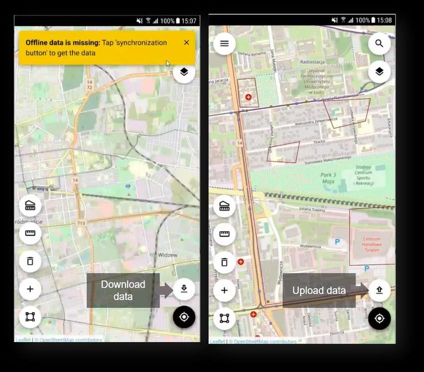
21 October 2021 25Better Control of the Offline Data Synchronization Process for Users of the Mobile App. Users of the GeoMedia WebMap Mobile app working offline will see the progress bar when downloading and uploading their offline data. Users can terminate the sync operation with the new Cancel button. A new set of user-friendly messages was introduced for better control and full view of the GeoPackage database creation process and data synchronization. 21 October 2021 26
Geometry Limitation Notification for Users
If a given type of geometry (e.g., an arc) is not supported and cannot be rendered, the app will inform the user.
A message appears when there are problems adding new objects (e.g., due to temporary unavailability of the
service). The Show details link provides more information about the error that occurred.

The address for an object that cannot be rendered is not displayed in the Dashboard, distance is not
calculated, and the navigation button is hidden. The Feature Info is also not available for features not
displayed.

21 October 2021                                                                                               27
Address History for GeoMedia WebMap Mobile Start Screen
After starting the mobile application, it is required to provide a configuration URL. Users working with several
configurations and switching between them need to enter the link to each one. All valid configuration URLs
provided are saved in the history. The next time the user would like to change configurations, they can choose
a saved URL from the list in the address history, making the configuration launch simpler and faster.

21 October 2021                                                                                               28
Display Feature Class Name in Feature Info Header of GeoMedia WebMap Mobile.
Enhancements for the Mobile app include the possibility to see the selected feature class name in the Feature
Info header. This may be especially useful when the user swipes the Feature Info screen for several objects
currently being selected.

21 October 2021                                                                                           29
Enhanced Offline Mode
With release 2022, preparing offline configuration is as simple as enabling the new Offline checkbox in the
Edit Work dialog. The offline configuration is prepared automatically and does not require any additional
configuration. If enabled, Works can be used in offline mode. There is no need to copy the Geopackage
database to the mobile device and then copy it back to the server anymore. With the enhanced offline mode,
you download the GPKG database that is dynamically generated on the server together with stored media
files. Data in GPKG files comes from WFS and/or WMS services. You can work in offline mode when there is
no internet connection. When the connection is back, you can upload your changes to the server (WFS-T
transaction).

21 October 2021                                                                                           30
In the GeoMedia WebMap Mobile app, the synchronization button is used to download and upload data.

21 October 2021                                                                                      31
Auto-Configured Primary Key
The primary key field is no longer available in the attributes view because the mobile application handles it on
its own. Backward compatibility is maintained, so if you had a primary key defined in the previous
configuration, it will be set in the app.

21 October 2021                                                                                               32
Auto-fill Values for Different Data Types
An administrator can provide a value for an attribute so inspectors in the field do not need to provide the value
in the mobile app. In the GeoMedia WebMap Mobile application, attributes with an auto-fill option defined are
displayed but cannot be edited by users. Auto-fill can be defined for the following attribute types:
     • Date
     • Date-time
     • Enumeration
     • Number
     • Text

21 October 2021                                                                                                33
Default Values
To boost fieldwork efficiency for GeoMedia WebMap Mobile app users, the ability to define default attribute
values was implemented. The default value is used when there is a need to automatically fill a form’s field
when creating a feature. The defined default value will always appear to the user in the form but can always be
changed.
For administrators, setting up the default value is as simple as enabling the Default value checkbox in the
Configure window for chosen the attribute and providing the value.
For Text type attributes, the following default value types exist:
• Static text – the text value from the input text will be inserted in the field
• Username – the user's login will be inserted in the field
• Current date – the date of modification will be used
• Current date and time – the date and time of modification will be used
21 October 2021 34Enhanced Display of Media Files GeoMedia WebMap provides an enhanced display of media files. Media files such as photo, video, audio, signatures, and documents (pdf) gathered with the mobile app can easily be reviewed in GeoMedia Desktop. In Mobile Publisher, to configure the media files for a memo type attribute, just pick the media type from the list in the Display Type column. The URL to the multimedia files is present as a media attribute in GeoMedia Desktop. Simply click the link to open the media. Please note that the Hyperlink option must be enabled for the WFS attribute. 21 October 2021 35
Remote Server Connection to the Mobile Backend
There is ability to connect to the mobile backend remotely. An administrator can set the URL to the mobile
backend server with configurations. Synchronization with the configuration on the remote server is ensured.
You can download the configuration from a connected remote server, and it will overwrite the local one.

All changes made in the configuration are saved on the provided remote server.

A Mobile Publisher server connection with Windows authentication is also available. For this purpose,
Windows authentication must be enabled in the IIS settings on the mobile backend side. A notification appears
when permissions are not sufficient. The Mobile Publisher group is used to control accounts that have
permission to access the server.

An administrator assigns users to the group. There is no need to provide any additional information when a
user is logged in and using a domain account.

21 October 2021                                                                                               36
Enabled Multiple Connections (Handling Several Sources)
Now you can make configurations with legend entries from different connections. Supported data sources
include not only WFS and Geopackage, but also WMS and WMTS. Configure legend entries from raster
services (WMS and WMTS). Raster layers can be used instead of a base map. WMS and WMTS legend
entries are read-only (there is no ability to create, delete, and update features in GeoMedia WebMap Mobile).
Feature Info works with WMS layers.

21 October 2021                                                                                             37
Handle Multiple Map Windows and Assign Works with a Map Window
The New Map Window combo box in the New/Edit Work properties dialog was introduced. It lists all open map
windows in GeoMedia Desktop. When adding a new job, the default active map window is chosen. You can
change the map window that will be used with the mobile configuration. The legend entries listed in Mobile
Publisher will be refreshed based on the currently selected map window. The map window relates to the Work,
so once the Work is created and saved, the map window cannot be changed.

21 October 2021                                                                                         38
Use Map Window Bounding Box (BBOX) as a Default
The same starting BBOX is set in the GeoMedia WebMap Mobile app as defined in the GeoMedia Desktop
Map window for the corresponding configuration. Zones are superior, which means that if a zone is defined in
the configuration, the map view will be adjusted to the zone area for the user.

21 October 2021                                                                                            39
Quick Start Guides in Mobile Publisher
Key settings must be configured in the GeoWorkspace before defining Works. The quick start guide is a new
feature that makes configuration even simpler. The user-friendly quick start guide will appear when the
workspace has any needed setting unconfigured, such as the proper GeoWorkspace coordinate system set or
registered data sources; when the active map window with legend entries is not present; or when at least one
user account is not defined for GeoMedia WebMap Mobile. The quick start guide dialog will list the task(s) that
need to be done. Short instructions on how to do it will be also provided. Simply do the steps listed in the quick
start guide dialog before you start to define Works.

21 October 2021                                                                                                40
Picture Style Support for the Point Feature Class
Point feature class can have the picture style defined. The picture style for points can be used irrespective of
configuration mode, online or offline. In addition, static and dynamic picture rotation is supported for both
online and offline configuration modes.

21 October 2021                                                                                                41
Honoring WFS/WMS Legend Entries’ Locatability in GeoMedia WebMap Mobile
The legend entry locatability setting in GeoMedia Desktop is directly mapped with the layer locatability in the
GeoMedia WebMap Mobile application. Setting a given WFS feature class or WMS layer’s Locatable option to
Off will prevent the possibility of clicking on the same layer in the GeoMedia Mobile application. To change the
legend entry locatability setting in the GeoMedia WebMap Mobile app, just set the Locatable option to the
desired state (On/Off) in the GeoMedia legend and then overwrite the configuration in the GeoMedia WebMap
Mobile Publisher.

21 October 2021                                                                                              42
New Base Maps (Here Maps/Bing Maps/Google Maps)
A base map pull-down list (in Edit Work dialog) is now enabled for a Work. You can pick from several base
maps:
    • Open Street Map
    • Bing Maps
    • Here Maps
    • Google Maps

You can also refrain from using any base map – just select “none” from the list.

Click the Options button to define more options and provide information that is needed by the API.

21 October 2021                                                                                             43
Display of GPS Accuracy in GeoMedia WebMap Mobile App A new feature in GeoMedia WebMap Mobile displays the most recent device request GPS accuracy value in the bottom right corner of the application screen, using the preferred system of units. Presented values are rounded to one decimal place, and units depend on GPS antenna strength. For example, the m/yd/ft will change into cm/in while obtaining signal from better equipment than a built-in cell phone GPS module. Displayed is the value from the most recent device request and updates depending on the location mode selected. This feature makes it possible to combine the software with Leica devices. GPS accuracy is also visible while editing and inserting new features. The GPS accuracy view can be disabled globally in the app settings. 21 October 2021 44
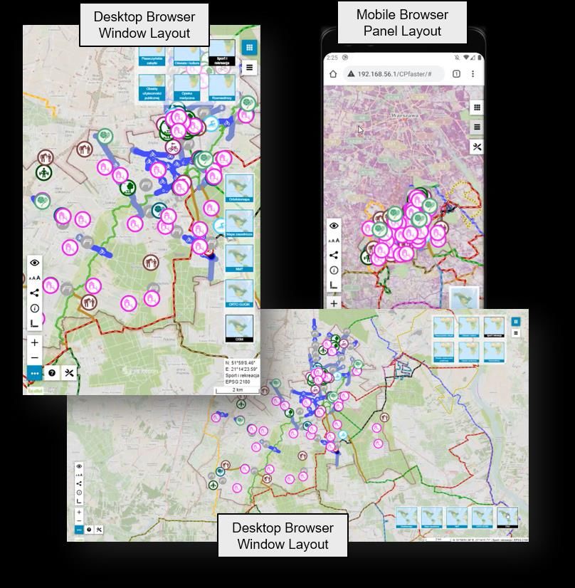
Geospatial Portal and Consumer Portal

Redesigned and Refreshed Consumer Portal UI
Consumer layout is a simplified and user-friendly entry-level layout for non-professional consumers of
geospatial data. It is dedicated to end-users who use maps for discovery and visualization, with minimum
clicks required. It is optimized for performance and user experience and takes advantage of the most up-to-
date web technologies and standards. With this release (16.7), the new window layout of Consumer Portal is
introduced. The new layout not only brings a fresh and attractive appearance to the application, but also a
number of functional improvements. Floating and modal windows help users organize the space on screen
more efficiently, improving productivity. Now users can freely arrange the view and use functions
simultaneously. All windows are resizable. Moreover, the position of the floating windows is remembered — if
the window has been moved by the user to a different place on the screen, then after it is closed and
reopened, its position will be the same as the last one.

These changes make the Consumer Portal layout easier to operate not only for desktop web browser users,
but also for mobile browser users. The refined UI does not distract users and focuses attention on important
functions.

Administrators can choose and set the layout while preparing the Consumer Portal configuration for users.
Both layouts are available: new, referred as to Window layout, and legacy, referred to as Panel layout. A new
option in Administration Console has been added to easily select and set the Consumer layout.

21 October 2021                                                                                                45
Smart Optimalization of Consumer Portal Layout
Starting from version 16.7, the Consumer Portal layout is automatically optimized to the web browser in which
it was launched, so that working with Consumer Portal is pleasant, easy, and as efficient as possible.

The GUI elements adapt to the screen size and layout (e.g., the base map switcher or map info bar is
displayed horizontally or vertically). The thumbnail size also changes slightly if needed.

Consumer detects web browser type (mobile and desktop). Since using the new Window layout on mobile
devices may be a bit uncomfortable for users, the Panel layout is always applied when Consumer Portal is
displayed on mobile devices, even if the new Window layout is set in Administration Console.

21 October 2021                                                                                            46
New Map Composition Switcher
The new Map Composition picker for displaying predefined maps is invoked using the buttons in the upper
right corner, making it handier and more intuitive to use. The smaller, more compact map picker has the same
functionality as before. It displays map composition thumbnails and allows for different map switching options if
those were included by the administrator in the given instance configuration.

When the Consumer Portal configuration contains a lot of map compositions, due to the new compact map
picker, the user has all map compositions at hand and does not have to scroll the panel to select a given one.
Users can resize the area for the Map Composition picker to display more or fewer map thumbnails. If not all
thumbnails fit in the set area, a slider appears.

The new map picker has been implemented for the new Window layout. The Map Composition tab in the
legacy Panel layout is replaced by the new map picker.

21 October 2021                                                                                               47
Improved Measurements UI in Consumer
With Consumer Portal, you can measure distances or an area of features displayed on the map and return the
geographic coordinates of a given point. Measurements have been available in the Consumer layout for quite
a long time, but in this 2022 release, the feature was slightly redesigned to improve the ease of use. The
Measurements control was moved to the bottom left toolbox. One measurement group button is always visible,
and when you click it, the buttons for particular measurement types are shown. The button for active
measurement is yellow. Measurement results are displayed on the map, over measured geometries.

21 October 2021                                                                                        48
Share Map
Efficient flow of information is very important in the modern world. Now you can easily share spatial data with
the community with the new Share Map feature. Portal users can easily send each other maps and their insight
into geospatial data. In the Consumer layout GUI, the new Share Map button was introduced in the left toolbar.
It opens a window with the URL to the current map being displayed. An additional button allows copying the
address quickly to the clipboard. A shared map preserves all its properties, including:

•   Current map composition

•   Layer settings

•   The selected base map

•   The map range and scale

21 October 2021                                                                                             49
LUWS Search Configuration for Consumer Portal
The LUWS — Location Utility Web Service — is an exceptionally flexible method for finding geospatial
information. It uses geocoding to determine the position and address of an object (POI). LUWS is a search
service that can be compared to Google's search services. With LUWS, users can search addresses, points of
interest, cadastral data, or any defined geospatial objects.

Users of Consumer Portal can search for objects from the Oracle database or WebMap Publisher Services.
Since version 16.7, they can also search for objects by using the LUWS service. With the new LUWS tab in the
Search Configuration section of the Administration Console, it is possible to add a working LUWS service to
the Consumer searches. Administrators can configure LUWS to be used with Consumer instances with a few
mouse clicks; no programming skills are required.

The LUWS service is provided within the GeoMedia WebMap product, so now WebGIS 2022 delivers a
complete solution for those who want to provide their users with the services of searching for geographic data
and objects.

21 October 2021                                                                                             50
Search for Coordinates in Consumer Portal
Consumer Portal gives you the ability to search for geographical coordinates.

The built-in coordinate search allows users to type coordinates in Decimal Degrees format (DD.ddddd; e.g.,
51.23456 21.78654) or Degrees, Minutes, Decimal Seconds (DMS; e.g., 51° 14' 4.42" N 21° 47' 11.54" E).
The coordinate separator can be a space or comma. To determine the direction, you can provide cardinals or
type a minus character for West and South (e.g., 34.23456S 61.78654W or -34.23456 -61.78654).

When coordinates are found, a pin showing the location on the map is displayed.

21 October 2021                                                                                          51
Base Maps in Consumer Portal
The new base map feature provides a background of geographical context for the content displayed within a
Map Composition. Users can change the base map of the current Map Composition at any time using the base
map switcher. The base maps available in the current Consumer Portal instance are prepared by the
administrator.

The process of creating base maps with Configuration Portal is quick and easy. Just select the Consumer
Base Map option for the map composition(s) in the workspace prepared and send the workspace to the
chosen Consumer Portal instance. Maps with the Consumer Base Map option enabled will be translated into
the workspace, as the base maps and will not be included in Map Compositions. This means the layers
included in them will not be visible in the legend.

The base map thumbnails for the base map selector in the Consumer Portal GUI are generated automatically
based on the Map Composition thumbnails defined for the Consumer Portal instance.

21 October 2021                                                                                        52
Integration of Google Maps and Consumer Portal
Consumer Portal handles Google Maps layers. This means users in Consumer Portal can view Google Maps,
explore Google Street View, and search for interesting objects by using the Google Maps Places search
service.

The Google Maps layer configured with Consumer Portal can be used as a base map and/or a standard layer
added to the legend. Users (for both base map and standard layer) can choose the type of Google Maps.

For standard layers displaying Google Maps, the user can choose the map type: roadmap, hybrid, traffic,
satellite, or terrain. The map type for a base map is selectable by using the standard base map switcher in
Consumer.

Google’s search service is also integrated. Consumer Portal users can search for a POI or address by using
the standard Consumer Portal search control integrated with Google Maps Places. Pins with the locations of
searched objects appear on the map.

Google Street View mode is also available with Consumer Portal. Exploring the Google Street View in
Consumer Portal is intuitive and uses well-known Google Street View native functionality in a floating and
resizable pop-up window. All you need to do is to enable Street View mode and place a marker on the map.
The Street View mode icon was added to the Consumer Portal bottom left toolbox. The marker on the map
shows your location and view direction and follows the position when you move in the Street View.

21 October 2021                                                                                               53
Configuration of Google Maps layer for Consumer Portal is as easy and intuitive as possible. All the
Administrator needs to do is run Administration Portal, prepare map composition with Google Maps, and send
it to a Consumer Portal instance.

21 October 2021                                                                                         54
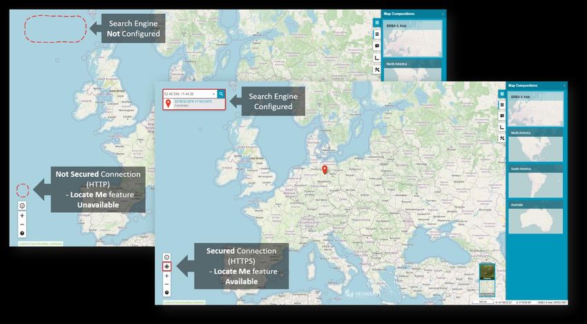
Disable Unavailable Elements (Search, Go to My Location)
Features that are not configured are not displayed on the Consumer Portal screen. This applies to the Go to
my location and Search features.

The Go to my location feature in Consumer Portal works only with secured (https://) connections. When a
Consumer Portal instance is configured over a non-secured connection, the Locate Me button and the Show
my location options on the Settings panel will not be displayed, and the features will not be available.
The same mechanism applies for Search bar. If no search engine is configured for Consumer Portal, then the
search controls are not displayed for users.

21 October 2021                                                                                           55
New Display Settings for Consumer Portal and Improved Legend Entry Behavior
Administrators can adjust the Consumer Portal to the users’ needs. With the new Appearance tab in the
Administration Console, the following display options can be enabled or disabled:
• Show Map Info
• Show Scale Bar
• Collapse Legend Group

21 October 2021                                                                                         56
Map Info provides a set of information about the active map:
•   Geographic latitude and longitude for the current cursor position in a map window
•   The name of active Map Composition
•   The coordinate system EPSG code of the current map

Map info is displayed in the bottom right corner on the screen application.

Scale Bar provides approximate information about the scale and distance on the map.

21 October 2021                                                                         57
The Collapse Legend Entry setting allows users to decide whether all layers in the Consumer Portal legend
should be collapsed on start or not. If enabled, all groups in the Consumer Portal Legend are collapsed when
Consumer Portal starts. This is especially useful when multiple map layers from several data sources are in
the workspace and as an administrator you do not want to show them all when the user runs Consumer Portal.

Preserve Legend Settings Between Map Composition Switches
Further improvements for Consumer Portal include a memory for legend changes during one session. When a
user adjusts layer properties (layer display on/off, transparency, layer order), switches the Map Composition,
and displays the previous Map Composition again, all layer settings will be the same as set before.

Consistent Mechanism of Scale Bounds Handling for WMS, WMTS, and WMPS
Consumer Portal handles scale bands advertised by Web Map Tile Service.

If scale ranges have been set for the data served by the WMTS service, the same ranges will apply when
displaying them in Consumer Portal. This function does not require any additional steps on the administration
side of the Consumer Portal, and it works in the same way as for the services (such as WMPS or WMS).

21 October 2021                                                                                             58
Allow Display of Long Layer Names in Consumer Portal
Now users can see the entire name of the feature class in Consumer Portal legend, even if the panel is shorter
than the name. Long names in the collapsed Consumer legend panel are still truncated, as was the case prior
to the 16.6.2 version, but expanding the legend control allows you to view the full name.

21 October 2021                                                                                            59
High Contrast Mode and Font Size Change (WAI Design)
The new High Contrast mode is now available for both Geospatial Portal and Consumer Portal. High contrast
makes Consumer and Geospatial Portal more accessible and usable to people with disabilities. High Contrast
mode was designed in accordance with W3C Web Accessibility Initiative (WAI) guidelines and standards and
is user-friendly — users can turn on or off the high contrast mode with one click of a button that is easily
accessible.

The next facilitation is the ability to change the size of the text font in the Geospatial Portal and Consumer
layouts. Three font sizes are available, and users can adjust the font size by pressing one dedicated button.

For the sake of product consistency in the portfolio, the same icons are used in both Consumer and Geospatial
Portal. The font size and contrast features work with every Portal theme, current and legacy. These features
reduce digital exclusion among your audience.

21 October 2021                                                                                                  60
Easier Registration of Google Maps API key for Portals
The Google Maps layer configured with Consumer Portal can be used as a base map and/or a standard layer
added to the legend. To configure and use Google Maps layers in the Geospatial Portal and/or Consumer
Portal layout, you must register a Google Maps API Key.

Administrators can register the Google key for a Geospatial Portal or Consumer instance directly in the
Administration Console. There is no longer a need to edit the Web.config file for each instance anymore.

Go to the Advanced options group in the Starting Configuration tab of Administration Console and type the
key value in the GoogleMaps API Key field.

21 October 2021                                                                                            61
Auto Adaptation of the Portal Layout to RTL Languages
One of the Geospatial Portal improvements relates to multilingualism. Portal starts in the same language as
the default setting for the web browser. You can change the language using the drop-down list that contains
the available languages. Geospatial Portal supports both LTR (left to right) and RTL (right to left) languages. If
a RTL language is selected (e.g., Arabic or Hebrew), the layouts will be automatically adapted. The display of
the controls for the layout is changed, and the text is aligned to the right.

21 October 2021                                                                                                 62
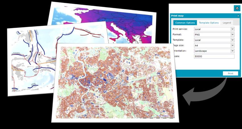
New Print Engine Support in Geospatial Portal
It is now possible to configure a Chrome print engine. You can print maps using Internet Explorer, phantomJS,
and Chrome (new). The engine definition is stored in the WebConfig file for the Portal instance and requires
only two parameters: the type of engine and the path to the executable file.

Sample:
\

21 October 2021                                                                                            63
Ability to Connect to Secured WFSG Services in Geospatial Portal
The new release gives you the benefit of registering an authorization-protected WFS-G service. In the New
Data Source window for the WFS-G connector, a new key button has been added. This key button opens a
registration form to provide credentials for the WFS-G service. After registering a secured WFS-G service, the
Geospatial Portal search engine works as it used to.

21 October 2021                                                                                             64
Improved UX for Switching Map Variants in Geospatial Portal Layouts
The combo box style map variant switcher was slightly redesigned in order to make it more consistent with the
rest of the Geospatial Portal styling.

21 October 2021                                                                                            65
Remove all Connections and Clear Workspace with One Command in Geospatial Portal
It is possible to remove all registered data sources and thus completely clear the workspace with one click.
Press the Remove All button located at the bottom of the Data Sources window. Then confirm the removal
operation, and all registered sources will be deleted, the legend entries will be removed, and the map window
cleared.

Now you can start to register new sources by selecting the Define a data source      button from the toolbar.

21 October 2021                                                                                             66
Using Consumer Portal SDK: Dynamically Refreshed Content
Consumer Portal now supports dynamically refreshed content so you can observe objects moving on the map
in real time (e.g., public transport, railway, metro, buses, planes, etc.). Dynamically refreshed content is based
on third-party API services. An SDK example showing how to implement dynamic layers has been introduced
and can be used to enhance Consumer Portal’s capabilities with a layer of data updated online.

In short, from a technical point of view, the response from the custom API format is parsed to the JSON format,
and all features are collected within the current bounding box and then displayed on the map. The layer is
refreshed by the time set.

Moreover, each dynamically displayed feature on the map has a tooltip with additional information. The tooltip
is displayed when the user clicks on the feature.

21 October 2021                                                                                                 67
You can also read