Roebuck Road Cycle Route (Bird Avenue to Goatstown Road) - Preliminary Design Report
←
→
Page content transcription
If your browser does not render page correctly, please read the page content below
Roebuck Road Cycle Route (Bird
Avenue to Goatstown Road)
Preliminary Design Report
Dún Laoghaire-Rathdown County Council
February 2022
Notice
This document and its contents have been prepared and are intended solely as information for Dún Laoghaire-
Rathdown County Council and use in relation to Roebuck Road Cycle Route
WS Atkins Ireland Limited assumes no responsibility to any other party in respect of or arising out of or in
connection with this document and/or its contents.

Document history
  Revision      Purpose description    Originated    Checked      Reviewed      Authorised        Date
 Rev 0         Draft                       DR           AB           CJP            CJP      Jan. 2022
 Rev 1         Incorporated                DR           AB           CJP            CJP      Feb. 2022
               Comments
 Rev 2         Incorporated Elected        DR           AB           CJP            CJP      Feb. 2022
               Members Comments

Client signoff
 Client                  Dún Laoghaire-Rathdown County Council
 Project                 Roebuck Road Cycle Route (Bird Avenue to Goatstown Road)
 Job number              5207277

 Client signature /
 date

5207277DG0018 | 2 | February 2022
Atkins | 5207277DG0018 rev 2.docx                                                                 Page 2 of 27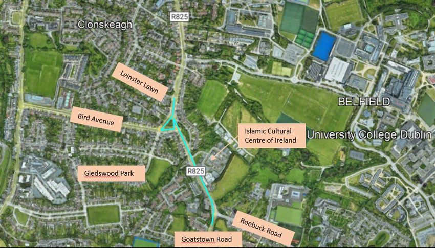
Contents
Chapter                                                      Page
1.      Introduction                                            5
2.      Objectives & Policies                                   6
2.1.    Project Objectives                                      6
2.2.    Project Related Policies                                6
3.      Existing Road Characteristics                           7
3.1.    Carriageway Features                                    7
3.2.    Junction Characteristics                                7
3.3.    Transport Infrastructure                                8
3.4.    Existing Utilities                                      8
3.5.    Landscaping                                             8
3.6.    Collision History                                       9
4.      Options Identification                                 12
4.1.    Background                                             12
4.2.    Reference Documents                                    12
4.3.    Design Principles & Options Considered                 12
4.4.    Options Considered for Appraisal                       12
4.5.    Options Not Considered for Appraisal                   15
4.6.    Preferred Option                                       16
5.      Preliminary Design                                     17
5.1.    Link Design                                            17
5.2.    Junctions & Entrances                                  17
5.3.    Signalised Pedestrian Crossings                        18
5.4.    Existing Services                                      19
5.5.    Land Take                                              19
5.6.    Transport Infrastructure                               19
5.7.    Pavements                                              20
5.8.    Traffic Analysis and Impacts.                          20
5.9.    Speed Data                                             21
5.10.   Landscaping Potential                                  21
6.      Preliminary Design Process Traffic Management Plan     22
6.1.    Introduction                                           22
6.2.    General Requirements                                   22
6.3.    Road Surfaces                                          22
6.4.    Footpath / Cycle Track Surfaces                        23
6.5.    Special Events                                         23
6.6.    Public Notices to be Managed by the Contractor         23
6.7.    Liaison Officer                                        23
6.8.    Phasing of Works                                       23
7.      Summary                                                24
7.1.    Pedestrians, Cyclists & Vehicular Traffic              24
7.2.    Environmental Impacts                                  24
7.3.    Conclusion                                             24
Appendix A.        Drawings                                    25
A.1.    Site Location                                          25

5207277DG0018 | 2 | February 2022
Atkins | 5207277DG0018 rev 2.docx                                   Page 3 of 27
A.2.    Option 1                                                                     26

Tables
Table 5-1 – Summary of Utility Companies’ Infrastructure                             19

Figures
Figure 1-1 – Scheme Extents and Location                                              5
Figure 3-1 - Example of existing cross section on Roebuck Road                        7
Figure 3-2 – Gledswood Drive Junction                                                 8
Figure 3-3 – Roebuck Road and R825 Junction on East                                   8
Figure 3-4 – Collision History along Roebuck Road                                     9
Figure 3-5 – Car Collision History along Roebuck Road                                10
Figure 3-6 – Bus Collision History along Roebuck Road                                10
Figure 3-7 – Cyclist Collision History along Roebuck Road                            11
Figure 3-8 – Pedestrian Collision History along Roebuck Road                         11
Figure 4-1 – Proposed Raised Cycle track                                             13
Figure 4-2 – At Grade Adjacent Track with Orca Bollards                              14
Figure 4-3 - Painted Cycle Track and Delineation on Roebuck Road                     15
Figure 4-4 - Existing on Road Cycle Provision on Bird Avenue                         16
Figure 4-5 - Existing on Road Cycle Provision                                        16
Figure 5-1 – Raised Cycle Track (as per NCM 4.3.4) and Typical Entrance Treatment    17
Figure 5-2 - Impacts of Tighter Corner Radii                                         17
Figure 5-3 – Raised Table Crossing                                                   18
Figure 5-4 – Signalised Crossing with Stopped Traffic and On-Road Cycle Facilities   18
Figure 5-5 - Shared Bus Stop Landing Zone                                            20
Figure 5-6 - Bird Avenue and Roebuck Rd. Traffic Study                               20
Figure 5-7 - Traffic Study at Roebuck Rd and Goatstown Rd.                           21

5207277DG0018 | 2 | February 2022
Atkins | 5207277DG0018 rev 2.docx                                                         Page 4 of 27
1.          Introduction
Dún Laoghaire-Rathdown County Council (DLRCC) proposes to enhance pedestrian, cycle facilities and adjusted
/ enhanced junction layouts along Roebuck Road from just north of Bird Avenue to the junction with Goatstown
Road. Atkins Consulting Engineers have been requested to assess the scheme extents and detail options to
meet the objectives of enhanced provision along Roebuck Road.
The scheme extents can be seen in Figure 1-1 below and reflected by a cyan line. This section of Roebuck Road
can be described as extending in a north-south direction over approximately 400m between Bird Avenue and
Goatstown Road.
To the east of the site location is the University College Dublin (UCD) Campus and the Islamic Cultural Centre of
Ireland. Various housing developments are located either side of the road along with a cluster of commercial
properties located in the vicinity of the public green space beside Bird Avenue and Gledswood Avenue.

                                    Figure 1-1 – Scheme Extents and Location

5207277DG0018 | 2 | February 2022
Atkins | 5207277DG0018 rev 2.docx                                                                     Page 5 of 27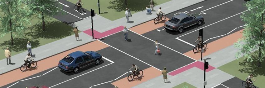
2.          Objectives & Policies
    2.1.        Project Objectives
The purpose of the proposed scheme as set out by DLRCC and the National Transport Authority is to enhance
the existing pedestrian and cycle facilities along Roebuck Road between Bird Avenue and Goatstown Road.
Along with the improvements to cycle facilities, adjustments will be made to existing junctions along the route as
part of these improvements. The route will cater for all cycle users including commuters, leisure and family cycling
groups. Ultimately when the route is delivered it will help to improve safety, including a reduction in vehicle
speeds, and is envisaged that it will contribute towards an increased number of trips in the area by pedestrians
and cyclists. The proposed works will tie-into the existing site limits, private and commercial accesses and
junctions along the route.
Additionally, the existing pedestrian crossing provision in the vicinity of Bird Avenue, Gledswood Avenue and the
adjacent green space are to be examined with a view to improvement of existing features.

    2.2.        Project Related Policies
2.2.1.      Dún Laoghaire-Rathdown County Development Plan 2016-2022
The aim of Dún Laoghaire-Rathdown County Council Development Plan is to develop sustainable and successful
communities across the county through the redevelopment of the established built-up areas and the promotion
of compact mixed-use urban villages. The Plan aims to increase the model share for walking and cycling in
particular for local trips to work, schools, retail and leisure. The Plan also aims to enhance safety for all modes
of transport in the county.
The proposed Roebuck Road Cycle route is in accordance with the following Policies set out by the Dún
Laoghaire-Rathdown County Council Development Plan:
•   Policy ST5: Walking and Cycling - It is Council Policy to secure the development of a high-quality walking
    and cycling network across the County in accordance with relevant Council and National policy and
    guidelines.
•   Policy ST6: Footways and Pedestrian Routes - The Council will continue to maintain and expand the footway
    and pedestrian route network to provide for accessible pedestrian routes within the County in accordance
    with best accessibility practice.
•   Policy ST7: County Cycle Network - It is Council policy to secure improvements to the County Cycle Network
    in accordance with the Dún Laoghaire-Rathdown Cycle Network Review whilst supporting the NTA on the
    development and implementation of the Cycle Network Plan for the Greater Dublin Area.

2.2.2.      Dún Laoghaire-Rathdown County Climate Change Action Plan 2019-2024
The Dún Laoghaire-Rathdown County Climate Change Action Plan sets out a range of actions that are to be
undertaken by the council to reduce the impact on climate change. The policy sets out the current climate change
impacts and greenhouse gas emission levels in the county, through the development of adaptation and mitigation
baselines. The actions in this plan have been gathered to close the gap between the current baselines and the
targets.
The proposed Roebuck Road Cycle scheme is in accordance with the following objectives of this policy:
•   Action T4: Develop and expand the County walking network – This includes the length of existing footpath
    within the scheme extents being improved in addition to providing enhanced and new pedestrian crossings.
•   Action T7: Develop and expand the cycle network – Increasing the number of Kilometres of cycle routes.
•   Action T8: Support the Greater Dublin Area Cycle Plan
•   Action T11: Cycle parking in public realm – Increase to the number of cycle parking spaces.
•   Action T13: Road maintenance improvements - Kilometres of regional and local roads with improvement
    works carried out.
•   Action T18: Engagement with citizens on new sustainable travel initiatives and schemes.

5207277DG0018 | 2 | February 2022
Atkins | 5207277DG0018 rev 2.docx                                                                        Page 6 of 27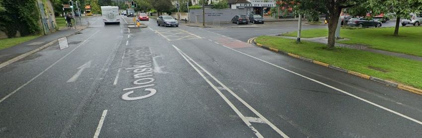
3. Existing Road Characteristics
The section of Roebuck Road under consideration is the R825 Urban road, extending between Bird Avenue and
Goatstown Road junction.
3.1. Carriageway Features
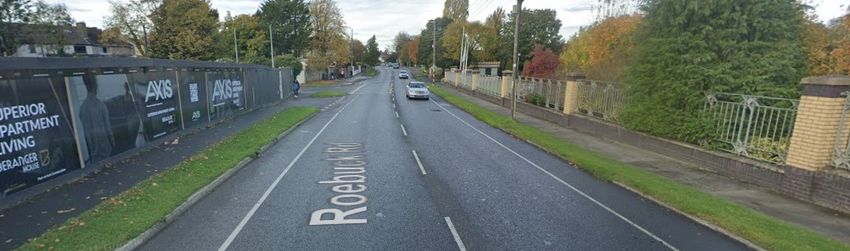
Roebuck Road is characterised as a single carriageway road with one lane in each direction. The available right-
of-way between existing boundary walls ranges from circa 16.0m to 17.0m which widens in certain locations at
some private and commercial accesses and green spaces. An example of the cross section on Roebuck Road
is shown in Figure 3-1.
The site extents commence at the junction with Leinster Lawn housing development to the north and finishes
south and east of the junction of Roebuck Road and Goatstown road. The existing carriageway has a total 2-
lane vehicle width of approximately 6m - 7m wide. The vehicle lanes are bound on both the east and west sides
by painted on road cycle tracks throughout the entire length of the scheme. Concrete footpaths are located along
the entire length of the road abutting private properties throughout some of which is located behind a verge which
separates the cycle track and footpath as seen in figure 3-1 below. The existing footpaths vary in width from 1m
- 2m wide throughout, there are three controlled pedestrian crossings located at the northern and southern ends
of the site extents; one located east west at Roebuck road and Gledswood Drive and the others on the east and
southern arms of the Roebuck Road and Goatstown road junction. Additional casual / dished crossings are
located along the footpaths along the route.
Figure 3-1 - Example of existing cross section on Roebuck Road
3.2. Junction Characteristics
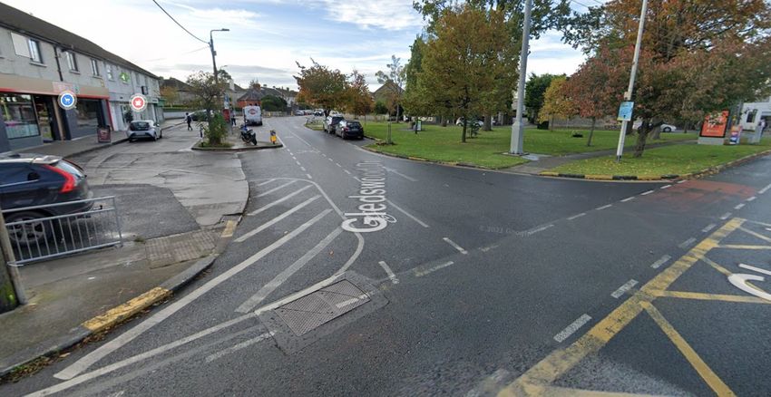
3.2.1. Gledswood Drive / Bird Avenue and Roebuck Road
The existing junction is signalised on all 3 arms. The sections of Bird Avenue and Gledswood Drive are for one-
direction of traffic only. Bird Avenue has two lanes on the exit allowing traffic to turn north and south. Roebuck
Road has one lane in each direction with a right turn filter lane allowing traffic turn from southbound of Roebuck
to Gledswood Drive. As mentioned above, there is a single 4.0m wide crossing of Roebuck Road to Gledswood
Drive and a curtesy crossing at all other locations of the junction. The existing curtesy crossing on Gledswood
Drive can be seen in Figure 3-2 following.
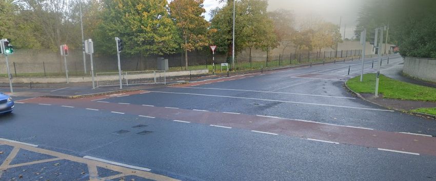
The junction of Roebuck and Goatstown road is signalised on all 3 arms and contains a relatively large radius
free left turn for traffic travelling south and wishing to travel to the east. A pedestrian crossing is provided on the
eastern arm and also on the free left turn. Parts of this junction can be seen in Figure 3-3 following
5207277DG0018 | 2 | February 2022
Atkins | 5207277DG0018 rev 2.docx Page 7 of 27
Figure 3-2 – Gledswood Drive Junction

                             Figure 3-3 – Roebuck Road and R825 Junction on East

   3.3.         Transport Infrastructure
Currently there is an on-road cycle track running along both sides of Roebuck Road. Existing bicycle parking
facilities are located at the bus stop on the south bound side of Roebuck Road, south of Gledswood Drive with
additional facilities also located at the green space area opposite the bus stop on Gledswood Drive and
commercial area.
In total there are 4 bus stops with shelters currently on the route and 3 indented bus stops, the remaining stops
along the route are inline bus stops.

   3.4.         Existing Utilities
Various utility services are located along the route above and below ground. Effectively this includes all key
services providers including BT, Eir, ESB LV, MV and 38KV, Gas, Potable Water, Virgin Media in addition to a
surface water network across the extent of Roebuck Road, Gledswood Drive and Bird Avenue also.

   3.5.         Landscaping
Landscaping features could be considered limited along the route and generally take the form of isolated trees
of varying type and size. There are some larger green areas to the south-eastern limit of the scheme in proximity

5207277DG0018 | 2 | February 2022
Atkins | 5207277DG0018 rev 2.docx                                                                      Page 8 of 27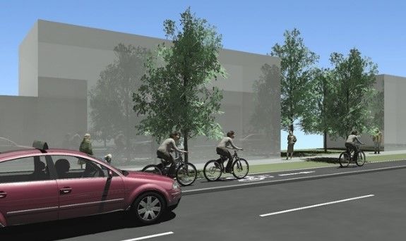
to the junction of Roebuck Road and Goatstown Road as well as at Bird Avenue and Rosemount Crescent all of
which are located within the existing green areas located at these locations. Additional details of the existing
landscaping features will be provided on receipt of a project tree survey which is currently being commissioned.

   3.6.         Collision History
The Road Safety Authority collision data base and mapping has been reviewed as part of the study. As reflected
in Figure 3-4 following, the data includes collision information from 2005 to 2016 inclusive and details collisions
as being minor, serious and fatal. The RSA records detail only those occasions were the incident was officially
recorded such as the Garda being present to formally record details of the incident. A total of 19 No. minor
casualties were recorded along the route. 8 No. of these incidents can be seen to include a bicycle.

The collision data is spread across the junctions and route as a whole. This is over the duration of 10 years. With
the data available, there is insufficient information to identify trends and underlying safety issues that exist along
the route.

                               Figure 3-4 – Collision History along Roebuck Road

5207277DG0018 | 2 | February 2022
Atkins | 5207277DG0018 rev 2.docx                                                                          Page 9 of 27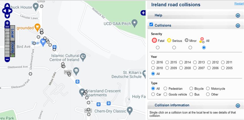
Figure 3-5 – Car Collision History along Roebuck Road

                             Figure 3-6 – Bus Collision History along Roebuck Road

5207277DG0018 | 2 | February 2022
Atkins | 5207277DG0018 rev 2.docx                                                    Page 10 of 27
Figure 3-7 – Cyclist Collision History along Roebuck Road
Figure 3-8 – Pedestrian Collision History along Roebuck Road
5207277DG0018 | 2 | February 2022
Atkins | 5207277DG0018 rev 2.docx Page 11 of 274. Options Identification
4.1. Background
Based on the constraints identified and the objectives for the route, multiple options were identified for the
scheme. Option identification was based on an appropriately detailed assessment of the route based on online
mapping, topographical survey, tree survey, on-site assessment, impacts on utilities; all of which have been
incorporated into the design.
4.2. Reference Documents
The following documents and standards were adhered to when developing potential design options:
• The National Cycle Manual
• Design Manual for Urban Roads and Streets (DMURS)
• TII Publications
• Preliminary Design and Guidance Booklet of Bus Connects
4.3. Design Principles & Options Considered
4.3.1. Design Principles
The following principles were considered in line with the National Cycle Manual:
• Quality of service - Quality of Service is a measurement of the degree to which the attributes and needs
of the cyclist are met. The aim of the scheme is to achieve the highest quality of service available on
each route.
• Effective Width calculator - The designed width of a cycle facility is comprised of the effective width, i.e.
the space that is “usable” by cyclists, as well as the clearances that will be required in different
circumstances.
• Segregation - Segregation refers to the physical separation of cyclists from motorised traffic and can be
provided by using kerbs and bollards. Where possible throughout the scheme a segregated cycle facility
is to be provided.
• Integration and access – Where possible the cycle facilities will be segregated for a safer more attractive
facility, integrating existing private and commercial accesses into the design while also providing cyclists
with increased segregation from motorised traffic.
• Transitions - Cyclists will frequently be required to make a transition from on-road to off-road etc.
Transitions will be designed to provide continuity, comfort and safety to cyclists.
• Impacts on other road users – The scheme will look to minimise the impact on other road users while
making a safer environment for all road users.
4.4. Options Considered for Appraisal
On the basis of the foregoing Design Principles, site constraints and considering the full suite of cycle
infrastructure options set out in the National Cycle Manual, the following feasible options are proposed, as
outlined in the Concept Option drawings in Appendix A.
4.4.1. Option 1 – Raised Cycle Track/Lane
Option 1 would see the provision of a kerbed and raised cycle track on each side of the trafficked lanes; cyclists
are segregated from traffic by means of this kerbing. This offers greater segregation to cyclists who wish to use
Roebuck Road for commuting. The provision of the kerbed solution would also have a narrowing effect on the
carriageway and likely a positive impact on reducing operational speeds for traffic due to this narrowing effect.
5207277DG0018 | 2 | February 2022
Atkins | 5207277DG0018 rev 2.docx Page 12 of 27Figure 4-1 – Proposed Raised Cycle track The strength of this option is that it would provide a high quality of service, is one of the most attractive, comfortable and safe cycling facilities, it would provide a consistent and continuous route along the entirety of the project. Naturally this option will come with increased costs and time for delivery in comparison to other options which are discussed in the following sections. It would be reasonable to assume that provision of this segregated facility would also make the route a more attractive option for cyclists and increase the numbers wishing to use cycling to commute, this would benefit both private individuals and business owners in the area and surrounding nearby community. In comparison to other options ongoing maintenance costs would likely be less as renewal of road markings and other cycle track markings such as cycle symbols and yield symbols would not be required. This option would also see existing pedestrian facilities being enhanced at junctions making the route safer and more attractive to use. These features include raised table crossings with tactile paving, reduction of junction radii where possible, widening and renewal of footpaths and additional signalised crossings at the junctions within the scheme. DMURS compliant junctions with radii of 6m would enhance the walking and cycle experience for those crossing junctions. Additionally the tighter radii should result in a more controlled movement of vehicles into private developments and to and from Roebuck Road which would reduce the risk of conflict (and potential reduced severity of conflict due to reduce speeds) between opposing vehicles also. 5207277DG0018 | 2 | February 2022 Atkins | 5207277DG0018 rev 2.docx Page 13 of 27
4.4.2.      Option 2 – Protected Cycle Lane
These proposals would provide orca bollards positioned between the cycle lane and trafficked carriageway. The
cycle lanes would remain at road level with the addition of the Orca bollards and Wand Orca bollards between
the cycle tracks and carriageway. Localised junction improvements would also be undertaken, these
improvements would aim to reduce the risk of conflict at the key conflict points. Cyclists would be given greater
segregation from vehicles at the junction of Roebuck Road and Goatstown road with the construction of
segregation islands at the junction and continuing to a point deemed safe to terminate. Similar to option 1 the
existing right turn lane from Goatstown Road to Roebuck Road would be removed in favour of providing additional
cycle infrastructure throughout the junction. Traffic light phasing would be key in order to manage with traffic
volumes and right turning vehicles from Goatstown Road which will be finalised at detailed design and overall
junction layout in terms of lane widths and final allocation for cyclists also wishing to move around and through
the junction.
Some weaknesses associated with this option are; Reduced segregation in comparison to Option 1. The
increased construction costs for junction improvements between Option 1 and 2 in overall terms would likely be
small. Additionally the signal phasing for the junction will be more complex along with the required signal
infrastructure to allow for the protected junction layout arrangement.
There may be some local reluctance to altering of existing junction/private access layouts, by reducing the width
of the junction mouth. The wide junctions may currently allow dual left and right exiting onto Roebuck Road which
would not be possible should the junction be curtailed and smaller radii provided. Overall the provision of Orca
bollards, Wand Orca bollards and refined junction geometry would likely to make the route more attractive for all
users both existing and those who may be considering using cycling as a means for commuting.

                            Figure 4-2 – At Grade Adjacent Track with Orca Bollards

5207277DG0018 | 2 | February 2022
Atkins | 5207277DG0018 rev 2.docx                                                                    Page 14 of 27
4.5. Options Not Considered for Appraisal The following options were considered for the route before being removed from the appraisal for reasons outlined in sections 4.5.1 and 4.5.2. 4.5.1. Option 3 – Do Nothing / Do Minimum The renewal of existing features throughout the site extents can be achieved at low cost and relative ease, within a short time frame. The renewal of the existing on road painted cycle lanes may be seen by some road users as an improvement on what has been there in recent years however these improvements will be effectively cosmetic and offer limited improvement to vulnerable road users along Roebuck Road while these are unlikely to make the route more attractive for those wishing to transfer to cycling as a mode of transport. Cycle lanes are soft provision measures on the carriageway that are reserved for the passage of cyclists. They include advisory cycle lanes and mandatory cycle lanes. Mandatory cycle lanes are marked by a continuous white line which prohibits motorised traffic from entering the lane, except for access and egress. As cycle lanes are visually and legally part of the carriageway cyclists are not physically protected. The strength of this option is that it would have the least impact on project delivery in terms of cost and programme. Figure 4-3 - Painted Cycle Track and Delineation on Roebuck Road The weakness of this option lies in the traffic characteristics of Roebuck Road and the limited safety benefit provided by this option. The road carries in the order of 5,500+ vehicles per day. Speed survey data taken along the route indicates that the 85%ile speed along the route is approximately 55km/h. These characteristics would suggest segregation is appropriate to provide a solution that is consistent with the National Cycle Manual which recommends segregated facilities where speeds of 50kph or higher exist along a route. For this reason this option was considered but not brought forward. The Do Nothing / Do Minimum option would also leave existing junction and pedestrian facilities unchanged and in a similar manner, fail to address the scheme objective of enhancing the provision of those walking along the route. A key part of the project is enhanced provision for pedestrian wishing to access the commercial properties at Gledswood Drive, this option of doing minimum would therefore fail to adequately address the need for those wishing to cross this road and junction. For these reasons and noting the scheme objectives, this option was not considered to be brought forward in the assessment process 4.5.2. Option 4 – 2-Way Cycle Track The primary weakness of this option is as a result of the significant issues with tying the proposal into the junctions at the east and west of the scheme extents in addition to accounting for the multiple private accesses along the route. Existing provision for cyclists on Roebuck and Bird Avenue typical have provision for cyclists on either side of the carriageway. There are existing signalised junctions that would require considerable adjustments to cater for a two-way cycle facility provided on one side of Roebuck Road. Note: The national cycle manual preference is to provide singular one-way cycle track on each side of the carriageway. 5207277DG0018 | 2 | February 2022 Atkins | 5207277DG0018 rev 2.docx Page 15 of 27
Figure 4-4 - Existing on Road Cycle Provision on Bird Avenue

                                    Figure 4-5 - Existing on Road Cycle Provision

An additional impact of this option would be the potential adjustments required to utility manholes and chambers
as a result of lowering some sections of existing footpaths or verge areas to road level should a shifting of the
main carriageway be required to allow for a two-way cycle track on one side of the trafficked lanes.
Such a change may ultimately require lowering of the overall service that is impacted while also having significant
time and cost implications where these alterations need to be agreed with a concerned utility provider.
The strength of this option should provide a high Quality of Service where provided in a suitable setting and
accounting for existing junctions and accesses. The challenges of tying into the termination points (existing
junctions) would negate these benefits and make the scheme unattractive as these tie-ins would be overly
complicated and challenging to negotiate for cyclists and pedestrians while also trying to adjust existing traffic
movements to facilitate this option. For these reasons this option was not considered to be brought forward in
the assessment process.

   4.6.         Preferred Option
Based on the criteria set out by DLRCC and the existing nature of the road, Options 1 is to be brought forward
as the preferred option, due to:
    •    The increased segregation for cyclists and vulnerable road users from vehicles.
    •    Improvements in pedestrian facilities
    •    Enhancement of the cycle experience along Roebuck Road
    •    Enhancement in bus stops scheme wide
    •    Reduction of vehicular speeds.

This is particularly relevant when the 85%ile speed of circa 55km/h is considered. The proposals are subject to
evolution and further changes at localised locations at detailed design stage.

5207277DG0018 | 2 | February 2022
Atkins | 5207277DG0018 rev 2.docx                                                                      Page 16 of 27
5. Preliminary Design
5.1. Link Design
As noted in Chapter 4 the preferred option for the route is Option 1 – Raised Cycle Track. An example of this is
shown in Figure 5-1. Where possible, the desirable widths of each element will comply with current design
standards which will be finalised at detailed design.
Figure 5-1 – Raised Cycle Track (as per NCM 4.3.4) and Typical Entrance Treatment
5.2. Junctions & Entrances
All junctions are to be upgraded with the following features:
• Junction radii to be tightened.
• Raised entry treatment on the adjoining roads and access to private developments and housing estates
etc. This will help reduce traffic speeds on through the junctions and also reduce the crossing width for
pedestrians.
• Tactile paving will be provided at the crossings to advise/warn visually impaired pedestrians.
Figure 5-2 below illustrates the principle of reduced corner radii from DMURS which reduces cyclist exposure to
turning vehicles , narrows pedestrian crossing widths(and times) and overall contributes to slower vehicle speeds.
Figure 5-2 - Impacts of Tighter Corner Radii
Across all private entrances for single-unit housing, footways, cycle lane/tracks and shared spaces shall be
continuous. This shall ensure that pedestrians, wheelchair users, cyclists, etc. have a facility without frequent
and localised level changes at each entrance.
5207277DG0018 | 2 | February 2022
Atkins | 5207277DG0018 rev 2.docx Page 17 of 27Figure 5-3 below illustrates the principle of raised table crossing from DMURS.
Figure 5-3 – Raised Table Crossing
To enable vehicles and bicycles cross the kerbs along these facilities, bevelled kerbs shall be provided, in line
with NCM 5.4.4.
5.3. Signalised Pedestrian Crossings
Controlled pedestrian crossings are proposed for Gledswood Drive, Bird Avenue, Roebuck Road, and the
junction with Goatstown Road. The existing 4m wide crossing on Roebuck Road is to be retained in its existing
location with required upgrades being made following consultation with Dublin City Council and DRLCC at
detailed design stage. The existing uncontrolled crossing on Gledswood Drive is to be upgraded to a controlled
crossing and incorporated into the adjacent junction signal phasing and timing. The existing uncontrolled crossing
on Bird Avenue is to be upgraded to signalised crossing also.
Currently at Bird Avenue and Gledswood Drive, pedestrians are required to wait for gaps in traffic and judge
when it is safe to cross the junction. The provision of the signalised crossings will take the risk and vulnerability
of error away and provide a clear passage of time where traffic is required to stop and then pedestrians can cross
the junction safely.
Figure 5-4 – Signalised Crossing with Stopped Traffic and On-Road Cycle Facilities
The existing Goatstown Road / Roebuck Road junction has a right turn lane for south to east bound traffic and a
left turn filter lane for north to east bound traffic. Standard (pelican) pedestrian crossings exist across the northern
and eastern arms of the junction and the existing left turn filter lane. There is no pedestrian provision across the
southern arm of the junction.
The proposed scheme will see all of the junction arms with controlled crossings. Additionally the junction widths
are to be reduced and corner radii reduced following the principles set out in section 5.2 above. The key objective
being enhanced provision and protection to pedestrians and cyclists moving through the junction.
5207277DG0018 | 2 | February 2022
Atkins | 5207277DG0018 rev 2.docx Page 18 of 27Signalised pedestrian crossings are to be 2.4m wide. Where this is to be utilised by cyclists, this will be increased
to 4.0m and access provision to the (Toucan – both cyclist and pedestrian) crossing for cyclists developed at
detailed design stage.
Uncontrolled pedestrian crossing facilities are proposed across all side roads as noted in section 5.2 above.
5.4. Existing Services
At the outset of the project, utility companies were contacted seeking information relating to their plant and
ducting within the route corridor. The following information was received.
Table 5-1 – Summary of Utility Companies’ Infrastructure
Service Provider Services Present
ESB Yes – Numerous underground lines, and overhead
lines
Virgin Media Yes
Irish water Yes
GNI Yes – Low and Medium pressure gas mains along all
route
Enet No.
BT Yes
Eir Yes – Numerous underground lines, and overhead
lines
A Ground Penetrating Radar (GPR) and utility survey has been undertaken and further investigation using slit
trenches is proposed. This survey will be used to inform the Detailed Design Phase in determining the location
of services to the most accurate extent possible. Any service diversions or protection works will be determined
at that Phase. Given the nature of the scheme, which is contained within the existing boundary extents, service
diversions are expected to be minimal and proposed junction upgrades will be expected to retain and protected
services in situ as part of the proposals. This will ensure a shorter timeframe for construction and minimise
disruption to traffic movements.
5.5. Land Take
The scheme proposed has been designed to have minimal impact on the surrounding environment and to avoid
the requirement for land take. All potential design options have been developed to fit within the current footprint
of Roebuck Road. By incorporating the new design in the existing footprint of Roebuck Road it omits the need
for additional land.
Existing parking that is located at the public green space of Bird Avenue and Gledswood Drive will be retained
and protected as part of the scheme. Improved pedestrian facilities(footpaths and signalised crossing) are
proposed at Bird Avenue and Gledswood Drive to allow access to these parking facilities and also to the adjacent
shops.
5.6. Transport Infrastructure
All existing bus stop locations have been retained. 3 No. of these will be kneeling bus stops with 1 No. proposed
to be a combination of an in-line bus stop and a shared bus stop landing zone arrangement. Combining both
types of bus stops is necessary due to space constraints. An example of the shared bus stop landing zone
arrangement is shown in Figure 5-5. This layout will allow safer movement for cyclists through the bus stop zone
while forcing / encouraging them to slow down when crossing the path of waiting pedestrians / bus users.
5207277DG0018 | 2 | February 2022
Atkins | 5207277DG0018 rev 2.docx Page 19 of 27Figure 5-5 - Shared Bus Stop Landing Zone
5.7. Pavements
In order to give the highest quality of service for cyclists, it is envisaged that a smooth asphalt surface course will
be used with 10mm aggregate as recommended by the National Cycle Manual, with sufficient base and
foundation layers to prevent failure. Shared streets, where cyclists share the trafficked lanes with vehicular traffic
shall be resurfaced to ensure a smooth ride surface and suitable skid resistance is achieved. Shared spaces and
footpaths are intended to be concrete to provide contrast compared to road and cycle surfaces, to aid people
with visual impairments. The exact construction depth for the footpath and cycle track pavements is subject to
detailed design. The extent of pavement renewal will be finalised at detailed design also.
5.8. Traffic Analysis and Impacts.
Traffic Analysis is currently being finalised on the preliminary design layouts and will aid the detail design stage
of the project. Two of the areas being studied are the junctions with Roebuck Road and Bird Avenue as shown
in figure 5-3 and the junction between Goatstown Road and Roebuck Road in order to identify traffic movements
through the junctions and the potential effects of removing both the left turn slip traveling southbound and the
right turn lane on Goatstown Road turning east onto Roebuck Road as shown in figure 5-4. This analysis will
optimise the signal timing and phasing to minimise the impact on the traffic movements. Pedestrian movements
will also be reviewed at both junctions as part of the analysis being undertaken.
Figure 5-6 - Bird Avenue and Roebuck Rd. Traffic Study
5207277DG0018 | 2 | February 2022
Atkins | 5207277DG0018 rev 2.docx Page 20 of 27Figure 5-7 - Traffic Study at Roebuck Rd and Goatstown Rd. 5.9. Speed Data Speed survey data taken along the route indicates that the 85%ile speed along the route is approximately 55km/h. These characteristics would suggest segregation is appropriate to provide a solution that is consistent with the National Cycle Manual which recommends segregated facilities where speeds of 50kph or higher exist along a route. 5.10. Landscaping Potential With the proposed removal of the left turn slip traveling southbound at the junction of Roebuck road and Goatstown road, this provides the opportunity to enhance the area and provide additional greenspace. Landscaping features such as planter pots, raised planting beds or art installations may be provided. Additional trees and shrubs can also be planted in order to enhance the junction. Similarly by tightening the junction radii on the southern side this provides addition green space to the back of the proposed footpath which can be utilised to further enhance the area. These elements will enhance the overall area in terms of green space in lieu of the paved areas that currently exist. Verges along the main road alignment will be planted with trees (or existing trees retained where possible) to enhance this provision while also contributing in a small way to segregating traffic from pedestrians and contributing to traffic calming. 5207277DG0018 | 2 | February 2022 Atkins | 5207277DG0018 rev 2.docx Page 21 of 27
6.          Preliminary Design Process Traffic
            Management Plan
    6.1.        Introduction
The following outlines the Preliminary Design Process Traffic Management Plan. This plan shall be updated at
the Detailed Design Phase as required, to be included within the Tender Documentation, whereby the
Contractor shall develop it in a Construction Stage Traffic Management Plan.

    6.2.        General Requirements
The Contractor shall develop the Design Stage Traffic Management Plan into a Construction Stage Traffic
Management Plan prior to undertaking the works. This will be done in a phased arrangement if and as required
by the NTA and DLRCC where the scheme is to be split. Phase 1 may incorporate the northern extents of the
scheme and the junction with Bird Avenue, phase 2 may concentrate on the southern end of the site
predominantly concentrating on the junction between Roebuck Road and Goatstown Road.
The Construction Stage Traffic Management Plan must be submitted in accordance with the safety health
management plan for review, prior to work commencing and shall include drawings detailing all proposed
temporary traffic management arrangements including those listed below:
•   The location and details of all proposed temporary traffic management measures including any lane closures
    and construction vehicle accesses;
•   Separate detailed plans in AutoCAD format showing all significant construction stages and phases;
•   The location and details of all temporary signage in full compliance with Chapter 8 including the potential for
    mobile VMS’s (if deemed appropriate by the contractor) and road markings;
•   Bespoke designs for each phase or stage must be included, standard traffic management layouts from Traffic
    Signs Manual Chapter 8 are not acceptable;
•   The location and details of all temporary safety barriers should be shown;
•   Details of any temporary traffic diversions including location and details of all diversion signage;
•   Details of any temporary pavement surfaces required to facilitate the works should be described.

Note: The Employer’s Representative and DLRCC may review and guide the contractor but will not approve
such Traffic Management Plans. FLRCC will issue a licence to the contractor should the TMP’s meet all criteria
set out.

The Construction Stage Traffic Management Plans including details of all proposed temporary traffic
management measures to facilitate traffic movements during the works must be lodged with the Employer’s
Representative and DLRCC for consideration, a minimum of 14 days prior to the date on which it is proposed to
commence the works.
The Project Supervisor for the Construction Stage (PSCS) / Contractor shall supply, erect and maintain, for the
duration of the Works, adequate warning and diversion signs and any other signs or traffic signals which may be
considered necessary.
The PSCS/Contractor shall keep clean and legible at all times all traffic signs, lamps, barriers and traffic control
signals and shall re-position, cover or remove them as necessary during the progress of the works.

    6.3.        Road Surfaces
The Contractor shall be responsible for the restoration of existing carriageways, in the event that they are
damaged as a result of the Works, temporary reinstatement will be put in place until permanent restoration is
carried out. Any restoration in roads shall be carried out to the satisfaction of the Employer’s Representative and
DLRCC.
It is the duty of the Contractor to ensure temporary signage is erected prior to permanent reinstatement of
surfaces to ensure road users are aware of temporary surfaces.

5207277DG0018 | 2 | February 2022
Atkins | 5207277DG0018 rev 2.docx                                                                          Page 22 of 27
6.4. Footpath / Cycle Track Surfaces The Contractor shall be responsible for ensuring that temporary footpaths must be sealed using either a bituminous bound material or concrete surfacing. Temporary footpaths consisting of compacted aggregates will not be permitted. Temporary reinstatement can be put in place until the permanent restoration is carried out, to the satisfaction of the Employer’s Representative and DLRCC. 6.5. Special Events The Contractor must ensure that the Programme and Construction Stage Traffic Management Plan is cognisant of and flexible to accommodate spikes in traffic flows on the project routes associated with planned major events in DLRCC Notwithstanding any consents the Construction Stage Traffic Management Plan by DLRCC, An Garda Síochána and the emergency services; Dún Laoghaire-Rathdown County Council and An Garda Síochána reserve the right to modify, remove or postpone the implementation of a particular Construction Stage Traffic Management system if deemed necessary by traffic conditions at any time during the works. Regular meetings between the Employer’s Representative, the Contractor, Dún Laoghaire-Rathdown County Council, the Gardaí and other emergency services shall be arranged by the Contractor and shall take place throughout the Construction Period; as well as at initiation or changes of Traffic Management layouts and at any other time deemed necessary by any of these parties. Such meetings shall take account of any special events that may require particular Traffic Management Operations. 6.6. Public Notices to be Managed by the Contractor Information on proposed Temporary Traffic Management measures, including potential delay times, locations and duration of lane closures etc. should be announced in advance using various media e.g. press releases, local/national radio stations and AA Roadwatch. The provision of Variable Message Signs (VMS) shall be considered by the contractor on all vehicular approaches to the site for a minimum of two weeks in advance of the proposed temporary traffic management works Appropriate signage, in accordance with Chapter 8 of the Traffic Signs Manual, shall be provided on all pedestrian approaches to the site to warn pedestrian of the construction works and inform them of any Temporary Traffic Management in place. Letters should also be issued to residents and business premises impacted directly by the works to inform them of upcoming changes to traffic arrangements on the project roads or affected side roads. 6.7. Liaison Officer The Contractor will be required to appoint a Liaison Officer who will be responsible for advising local residents, businesses and property owners of proposed traffic management plans. The Liaison Officer is required to carry out a leaflet drop to all residences and businesses affected by any proposed traffic restrictions, 2 weeks prior to implementing any traffic management plan, and prior to any and all subsequent changes to traffic management. The PSCS shall also provide information including qualifications of the Traffic Operations Supervisor, who shall be responsible for the implementation of the developed TMP onsite. Where access to residences or property directly impacted upon by the works, then a suitable access/egress procedure should be agreed with the relevant parties and coordinated through the Temporary Traffic Operations Supervisor. 6.8. Phasing of Works During the phasing of works it is essential that there is a maximum of one lane closure and where possible allow two-way traffic flow as work is being carried out. 5207277DG0018 | 2 | February 2022 Atkins | 5207277DG0018 rev 2.docx Page 23 of 27
7.          Summary
   7.1.         Pedestrians, Cyclists & Vehicular Traffic
The proposed scheme will deliver a safe, accessible and attractive route for pedestrians with a minimum 2m wide
footpath provided. New and improved crossings will allow pedestrians to cross the road in a safe manner.
Facilities for those users with visual or mobility impairments will be much improved, with tactile paving, flush kerbs
and raised crossings provided throughout on side roads and development access points.
The provision of this high-quality cycle infrastructure (QoS Level A+) will provide an enhanced route for cyclists
linking many residential, educational and commercial areas. This is expected to offer an attractive option to new
and future cyclists and walkers who may wish to use the route rather than motorised methods of transport.
In general, there will be limited impacts on the existing vehicular traffic on the surrounding road network, however
given the nature of the proposals (e.g. reduction in carriageway width, reduction in junction radii and an increase
in pedestrian crossings) there will be a slowing of traffic speeds compared to existing, and therefore some
increase in journey time will occur. The improvements to pedestrian and cycling infrastructure will encourage a
modal shift away from the private vehicle, which should have a corresponding effect on reducing traffic volumes
locally.

   7.2.         Environmental Impacts
It is not expected that the proposed scheme will have a significant impact to the receiving environment.
A targeted tree survey is being undertaken based on the preliminary design and the expert advice of an
arboriculturist will be used to determine the value, age and condition of all trees along the proposed route and
any mitigation required where affected. Once the tree survey is received and detailed design carried out, the
impact on the existing trees will be finalised. Final landscape proposals will be outlined in the detailed design
drawings on discussions with the NTA and Dún Laoghaire-Rathdown County Council. It is anticipated that existing
landscape features will be enhanced particularly at the junction of Roebuck Road and Goatstown Road and some
enhancements in other localised locations as a result of the proposed scheme.

   7.3.         Conclusion
The proposed development will help to reduce the number of potential conflicts between cyclists, pedestrians,
and vehicular traffic through the use of segregated facilities, reduced junction radii and improved pedestrian
crossing facilities. The highlights of the scheme include;
    •    Cyclists will have improved priority throughout the route; the proposed segregation and priority through
         minor junctions will help increase cycling progression
    •    Vulnerable road users shall be catered for through formalised crossing facilities in the form of raised
         tables on side roads and minor access roads
    •    An additional pedestrian crossing at the junction of Roebuck Road and Goatstown Road will also be
         provided.
    •    Additional footpaths will be provided at the green area at Bird Avenue to link people parking cars to the
         commercial properties
    •    2 additional signalised pedestrian crossing points will be provided at Bird Avenue and Gledswood Drive
    •    Bus stop facilities will be improved scheme wide
    •    Provision of dished kerbing and tactile paving in line with best practice
    •    Localised junction improvements to aid vulnerable road users at locations such as Gledswood Park and
         Rosemount Crescent.

5207277DG0018 | 2 | February 2022
Atkins | 5207277DG0018 rev 2.docx                                                                         Page 24 of 27
Appendix A. Drawings A.1. Site Location 5207277DG0018 | 2 | February 2022 Atkins | 5207277DG0018 rev 2.docx Page 25 of 27
A.2.        Option 1

5207277DG0018 | 2 | February 2022
Atkins | 5207277DG0018 rev 2.docx   Page 26 of 27
WS Atkins Ireland Limited
Atkins House
150 Airside Business Park
Swords
Co. Dublin
K67 K5W4

© WS Atkins Ireland Limited except where stated otherwise

5207277DG0018 | 2 | February 2022
Atkins | 5207277DG0018 rev 2.docx                           Page 27 of 27
You can also read