SAFETY ELEMENT WILDOMAR - CITY OF - City of Wildomar
←
→
Page content transcription
If your browser does not render page correctly, please read the page content below

CITY OF
WILDOMAR

SAFETY
ELEMENT

   Adopted on
October 13, 2021

SAFETY ELEMENT

1. Introduction ................................................................................................................................................................. 1

       Purpose, Scope, and Content ....................................................................................................................................... 1
       Regulatory Framework ................................................................................................................................................ 2
       Relationship to Other Documents................................................................................................................................ 3
       Relationship to the Emergency Management Department .......................................................................................... 4
       Hazard Reduction ........................................................................................................................................................ 4
       Vulnerable Communities ............................................................................................................................................. 5
       Climate Change Vulnerability ..................................................................................................................................... 7

2. Existing Conditions ................................................................................................................................................... 10

       Code Conformance and Development Regulations ................................................................................................... 11
       Seismic and Geologic Hazards .................................................................................................................................. 13
       Flood and Inundation Hazards ................................................................................................................................... 27
       Fire Hazards .............................................................................................................................................................. 40
       Air pollution .............................................................................................................................................................. 53
       Hazardous Waste and Materials ................................................................................................................................ 59
       Disaster Preparedness, Response, and Recovery ....................................................................................................... 63
       Additional Climate-Related Hazards ......................................................................................................................... 73
       Implemenation Measures........................................................................................................................................... 79

Appendices

       Appendix A: Vulnerability Assessment Results........................................................................................................ 89

 Wildomar Safety Element – August 2021                                                                                                                             SE-i
SAFETY ELEMENT

Tables

    Table S-1: Chances of Significant Earthquakes on Major Riverside County Faults ................................................ 15
    Table S-2: Fires in Wildomar, 1950-2019 ................................................................................................................. 44
    Table S-3: Implementation Measures ........................................................................................................................ 80

Figures

                      Regional Fault Lines ............................................................................................................................ 16
                      Seismic Hazard Program Liquefaction Zone ....................................................................................... 18
                      Landslide Susceptibility ....................................................................................................................... 19
                      Subsidence Zone .................................................................................................................................. 22
                      Flood Hazard Zones ............................................................................................................................. 30
                      Dam Inundation .................................................................................................................................... 33
                      Fire Hazard Severity Zones .................................................................................................................. 42
                      Wildland/Urban Interface ..................................................................................................................... 43
                      Historical Wildfire Perimeters.............................................................................................................. 45
                      Diesel Particulate Percentile ................................................................................................................. 56
                      Ozone Percentile .................................................................................................................................. 57
                      PM2.5 Percentile .................................................................................................................................... 58
                      Residential Parcels with Evacuation Constraints ................................................................................. 66

 Wildomar Safety Element – August 2021                                                                                                                     SE-ii
SAFETY ELEMENT
1. INTRODUCTION
PURPOSE, SCOPE, AND CONTENT
The Safety Element conveys the City of Wildomar’s (City’s) goals, policies, and actions to minimize the hazards
to safety in and around Wildomar. This Safety Element will replace the 2003 County/City Safety Element upon
adoption. It identifies the natural and human-caused hazards that affect existing and future development and
provides guidelines for protecting residents, employees, visitors, and other community members from injury
and death. It describes present and expected future conditions and sets policies and standards for improved
public safety. The Safety Element also seeks to minimize physical harm to the buildings and infrastructure in
and around Wildomar to reduce damage to local economic systems, community services, and ecosystems.
Some degree of risk is inevitable because the potential for many disasters cannot be completely eliminated and
the ability to predict such disasters is limited. The goal of the Safety Element is to reduce the risk of injury,
death, property loss, and other hardships to acceptable levels. One of the fundamental values of the Vision for
Wildomar, as adopted by the City Council on April 12, 2017 (via Resolution No. 2017-12), highlights the
importance of safety to the people of Wildomar:
“The City of Wildomar will be a safe and active community with responsible growth and
quality infrastructure while keeping a hometown feel.”
This “value” underlies the policy direction of the Safety Element and is further defined by the following Vision
statement:
“Considerable protection from natural hazards such as earthquakes, fire, flooding, slope
failure, and other hazardous conditions is now built into the pattern of development authorized
by the General Plan.”
Based on the direction provided by the Vision, and in compliance with state law, the primary objective of the
Safety Element is to “reduce death, injuries, property damage, and economic and social impact from hazards.”
The Safety Element serves the following functions:
Develops a framework by which safety considerations are introduced into the land use planning process.
Wildomar Safety Element – August 2021 SE-1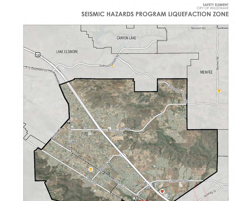
SAFETY ELEMENT
Facilitates the identification and mitigation of hazards for new development, and thus strengthens
existing codes, project review, and permitting processes.
Presents policies directed at identifying and reducing hazards in existing development.
Strengthens earthquake, flood, inundation, and wildland fire preparedness planning and post-disaster
reconstruction policies.
Identifies how hazards are likely to increase in frequency and intensity in the future and provides policies
to increase community resilience.
REGULATORY FRAMEWORK
Under state law, all counties and incorporated communities in California must prepare a General Plan, which
must address several topics, one of which is public health and safety. The Safety Element addresses this topic
in accordance with state requirements, which are laid out in California law, particularly Section 65302(g) of the
California Government Code. State law requires that the Safety Element address the following:
Protect the community from risks associated with a variety of hazards, including seismic activity,
landslides, flooding, and wildfire, as required by the California Government Code Section 65302(g)(1).
Map and assess the risk associated with flood hazards, develop policies to minimize the flood risk to
new development and essential public facilities, and establish effective working relationships among
agencies with flood protection responsibilities, as required by California Government Code Section
65302(g)(2).
Map and assess the risk associated with wildfire hazards, develop policies to reduce the wildfire risk to
new land uses and essential facilities, ensure there is adequate road and water infrastructure to respond
to wildfire emergencies, and establish cooperative relationships between wildfire protection agencies, as
required by California Government Code Section 65302(g)(3).
Assess the risks associated with climate change on local assets, populations, and resources. Note existing
and planned development in at-risk areas and identify agencies responsible for providing public health
and safety and environmental protection. Develop goals, policies, and objectives to reduce the risks
associated with climate change impacts, including locating new public facilities outside of at-risk areas,
providing adequate infrastructure in at-risk areas, and supporting natural infrastructure for climate
adaptation, as required by California Government Code Section 65302(g)(4).
Wildomar Safety Element – August 2021 SE-2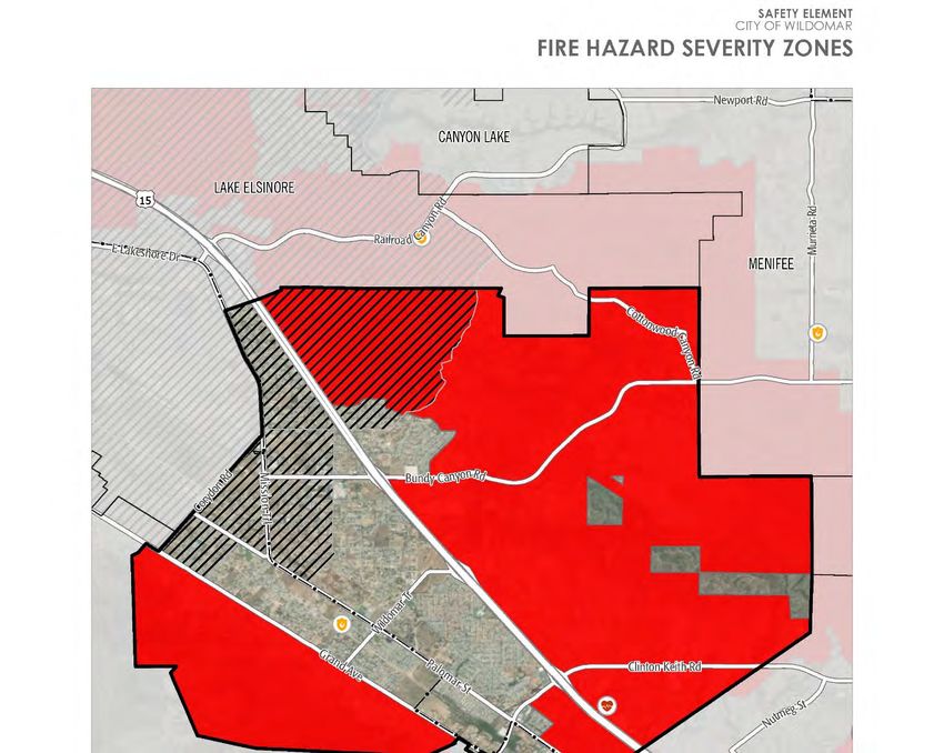
SAFETY ELEMENT
Identify residential developments in any hazard area identified that do not have at least two emergency
evacuation routes, as required by California Government Code Section 65302(g)(5).
RELATIONSHIP TO OTHER DOCUMENTS
The Wildomar Safety Element does not exist in a vacuum but is instead one of several plans that address public
safety and related topics. The Safety Element must be consistent with these other plans to minimize conflicts
between documents and ensure that the City has a unified strategy to address public safety issues. The Safety
Element incorporates information, technical analyses, and policies from these other documents where
appropriate to help support this consistency.
OTHER GENERAL PLAN ELEMENTS
The Safety Element is one of several elements of the Wildomar General Plan. Other social, economic, political,
and aesthetic factors must be considered and balanced with safety needs. Rather than compete with the policies
of related elements, the Safety Element provides policy direction and designs safety improvements that
complement the intent and policies of other General Plan elements. Crucial relationships exist between the
Safety Element and the other General Plan elements. How land uses are determined in areas prone to natural
hazards, what regulations limit development in these areas, and how hazards are mitigated for existing
development, are all issues that tie the elements together. For instance, Land Use Element diagrams and policies
must consider the potential for various hazards identified in the Safety Element and must be consistent with the
policies to address those hazards. The Multipurpose Open Space Element is also closely tied to the Safety
Element. Floodplains, for example, are not only hazard areas, but often serve as sensitive habitat for threatened
or endangered species or provide recreation or passive open space opportunities for residents and visitors. As
such, flood and inundation policies balance the need to protect public health and safety with the need to protect
habitat and open space. Safety Element policies, especially those concerning evacuation routes and critical
facilities, must also be consistent with those of the Circulation Element. The City’s Circulation Plan routes are
considered the backbone routes for evacuation purposes. Policies and information in this Safety Element should
not conflict with those in other elements.
CITY OF WILDOMAR LOCAL HAZARD MITIGATION PLAN
The City of Wildomar’s Local Hazard Mitigation Plan (LHMP) is a plan to identify and profile hazard
conditions, analyze risk to people and facilities, and develop mitigation actions to reduce or eliminate hazard
risks in Wildomar. The City prepared the LHMP in accordance with the federal Disaster Mitigation Act of 2000
Wildomar Safety Element – August 2021 SE-3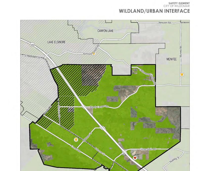
SAFETY ELEMENT
and the Federal Emergency Management Agency’s (FEMA’s) LHMP guidance. The mitigation actions in the
LHMP include both short-term and long-term strategies, and involve planning, policy changes, programs,
projects, and other activities. The LHMP and Safety Element address similar issues, but the Safety Element
provides a higher-level framework and set of policies, while the LHMP focuses on more specific mitigation,
often short-term, actions. The LHMP, as its name implies, focuses on mitigation-related actions, while the Safety
Element also includes policies related to emergency response, recovery, and preparation activities. The current
LHMP is incorporated into this Safety Element by reference, as permitted by California Government Code
Section 65302.6.
RELATIONSHIP TO THE EMERGENCY MANAGEMENT DEPARTMENT
The County of Riverside Emergency Management Department (EMD) is responsible for providing emergency
management services. EMD has four divisions that combine traditional emergency management, public health
disaster management, and emergency medical services into a single, comprehensive, all hazards department.
EMD works with local cities such as Wildomar, fire and law enforcement agencies, and special districts to
support and implement emergency mitigation and preparation activities across Riverside County, secure
resources for first responders, and coordinate with state and federal emergency agencies. EMD’s emergency
preparation and response activities, including many of the Safety Element policies implemented by the City in
coordination with EMD, are laid out in this Safety Element.
HAZARD REDUCTION
Hazard-reduction programs are designed to improve the safety of existing development. For example, older
structures, built to superseded code standards, may need seismic upgrading. Owners of older structures may
voluntarily upgrade, be strongly incentivized to upgrade, or be required to do so. Additional examples of hazard-
reduction programs include:
Strengthening pipelines and developing emergency back-up capability by public utilities serving the City
of Wildomar;
Collaborating with water purveyors to ensure adequate fire flow during emergencies;
Creating defensible space around buildings to prevent damage from wildfires;
Planning for emergency response at the government and individual level to reduce the risk to the public
from hazards; and
Wildomar Safety Element – August 2021 SE-4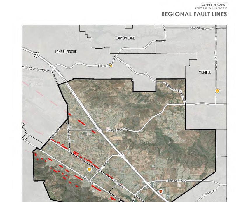
SAFETY ELEMENT
Identifying unsafe structures and posting public notices.
To reduce hazards in areas mapped as hazard zones, the City of Wildomar uses a combination of methods:
Special investigation and reporting requirements;
Land use planning;
Real-estate disclosure;
Incentives to encourage hazard mitigation;
Public education; and
Disincentives, including fines and fees for those who choose to take the risk of that hazard.
VULNERABLE COMMUNITIES
Due to financial limitations, mobility challenges, and lack of access to medical care, the most vulnerable
populations to environmental pollution and other hazards include households in poverty, seniors living alone,
outdoor workers, and persons experiencing homelessness. Based on the CalEnviroScreen 3.0 model, which uses
pollution and population characteristic indicators to assess pollution burden within communities, overall
pollution burden is relatively low.1 However, there are communities that may be disproportionately impacted
by pollution and hazards.
Low-income communities in Wildomar provide an effective lens for assessing where pollution and hazards may
disproportionately be affecting vulnerable communities. Therefore, this Safety Element defines vulnerable
communities as low-income areas that are disproportionately affected by environmental pollution and other
hazards that can lead to negative health effects. A low-income area is defined as an area with household incomes
at or below 80 percent of the statewide median income or with household incomes at or below the threshold
designated as low income by the Department of Housing and Community Development’s list of state income
limits, which is approximately $59,993 in Wildomar.
1
California Office of Environmental Health Hazard Assessment. 2018. CalEnviroScreen 3.0.
https://oehha.ca.gov/calenviroscreen/report/calenviroscreen-30.
Wildomar Safety Element – August 2021 SE-5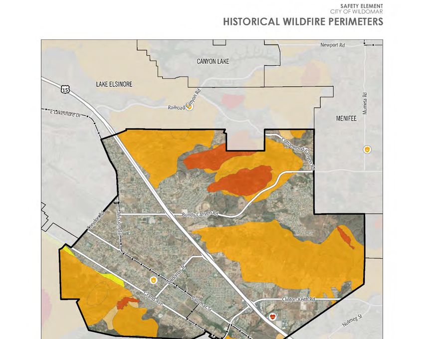
SAFETY ELEMENT
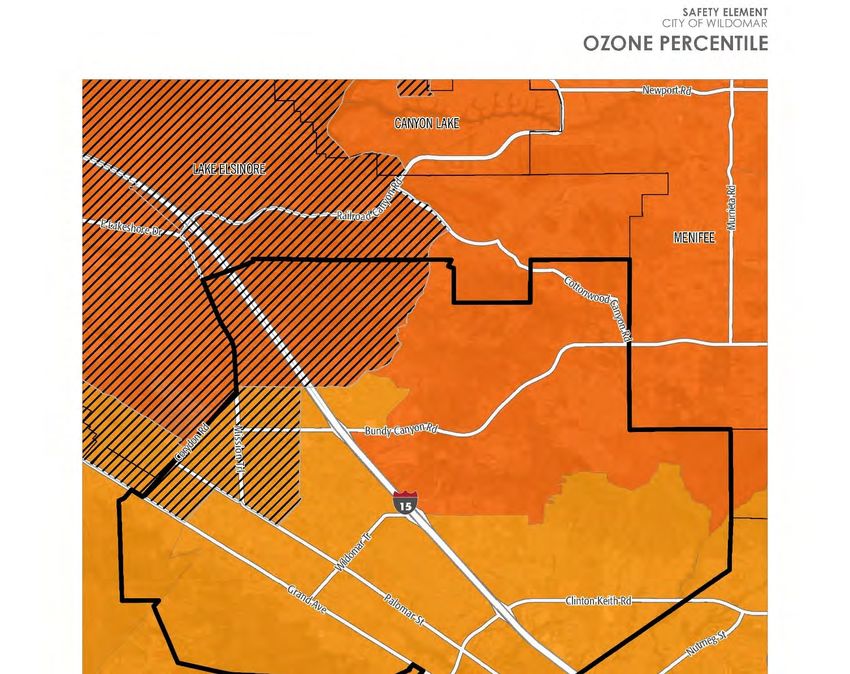
Vulnerable communities in Wildomar are particularly affected by pollution and hazards in the northwest region
of the city, along Corydon Road and Mission Trail. Vulnerable communities are often affected first and at greater
levels by pollution and climate-related impacts. These communities are burdened with poorer air quality and
pollution and face a higher risk of flood and wildfire hazards. More specifically, air quality impacts are
associated with elevated concentration levels of diesel particulate, ozone, and particulate matter 2.5 (PM2.5).
Although flood risk is present, the 100- and 500-year flood zone is limited to areas along the city boundary, near
Corydon Road and Mission Trail. To the east of Interstate 15 (I-15), vulnerable communities are within a very
high wildfire hazard severity zone.
Some hazards, such as toxins or traffic hazards, may be dangerous enough to harm human health in isolation.
However, some hazards may not be harmful to health by themselves, but become harmful when combined with
other health risks to a community. This is a compounded health risk, often referred to as cumulative risk. Today,
people are often exposed to multiple health risks, such as ozone and particulate matter, while concurrently living
in unhealthy housing conditions and/or experiencing poverty and other socioeconomic stressors that are
associated with negative health outcomes. These conditions are experienced more often by vulnerable
communities.
“Environmental justice” is defined in California law as the fair treatment of people of all races, cultures, and
incomes with respect to the development, adoption, implementation, and enforcement of environmental laws,
regulations, and policies. “Environmental justice” includes, but is not limited to, all of the following:
The availability of a healthy environment for all people.
The deterrence, reduction, and elimination of pollution burdens for populations and communities
experiencing the adverse effects of that pollution, so that the effects of the pollution are not
disproportionately borne by those populations and communities.
Governmental entities engaging and providing technical assistance to populations and communities most
impacted by pollution to promote their meaningful participation in all phases of the environmental and
land use decision-making process.
At a minimum, the meaningful consideration of recommendations from populations and communities
most impacted by pollution into environmental and land use decisions.
Wildomar Safety Element – August 2021 SE-6SAFETY ELEMENT
Environmental justice in the community can be implemented in various ways, such as through policies and
actions that improve sustainability and resilience, protect community health, and prioritize safety. This Safety
Element identifies where vulnerable communities experience existing and likely future hazardous conditions
and other public safety issues in Wildomar and incorporates environmental justice into its policies and actions
to address specific hazards for vulnerable communities in Wildomar. These policies and actions aim to reduce
the unique or compounded health risks.
CLIMATE CHANGE VULNERABILITY
Changes to the global climate system are expected to affect future occurrences of natural hazards in and around
Wildomar. Many hazards are projected to become more frequent and more intense in coming years and decades,
and in some cases, these trends have already begun. According to California’s Fourth Climate Change
Assessment,2 Wildomar can expect the following changes to climate-related hazard events:
Both droughts and floods are expected to become more frequent as precipitation is expected to occur in
fewer, more intense storms due to climate change. Although Wildomar is likely to experience little
change in overall precipitation levels from climate change, the region is also expected to see an increase
in the number of extreme precipitation events. As a result, floods are expected to occur more often in
Wildomar, and climate change may expand the parts of the city that are considered flood-prone. Climate
change is expected to increase the frequency and severity of droughts that cause soil to dry out and
condense. When precipitation does return, more water runs off the surface rather than being absorbed
into the ground, which can lead to floods.
Warmer temperatures are projected to cause an increase in extreme heat events. Because extreme heat is
relative to the area, this means that extreme heat events may occur anywhere in Riverside County. The
number of extreme heat days, defined in Wildomar as a day when the high temperature is at least 105
degrees Fahrenheit (°F), is expected to rise from a historical annual average of 4 to between 25 and 37
by the middle of the century (2041 to 2060), and to between 34 and 58 by the end of the century (2070
to 2099). In addition to the increases in extreme heat events, Wildomar is expected to see an increase in
the average daily high temperatures. Extreme heat poses a significant human health risk, especially to
senior citizens, outdoor workers, and persons who do not have access to adequate cooling, including
2
Bedsworth, Louise, Dan Cayan, Guido Franco, Leah Fisher, Sonya Ziaja. (California Governor’s Office of Planning and Research,
Scripps Institution of Oceanography, California Energy Commission, California Public Utilities Commission). 2018. Statewide
Summary Report. California’s Fourth Climate Change Assessment. Publication number: SUMCCCA4-2018-013.
Wildomar Safety Element – August 2021 SE-7SAFETY ELEMENT
people experiencing homelessness. Some buildings and infrastructure systems may be damaged by very
high temperatures, constraining their ability to meet community needs.
Climate change can increase the rates of infection for various diseases because many of the animals that
carry diseases are more active during warmer weather. There are a number of diseases that are linked to
climate change and can be harmful to the health of Wildomar community members, such as hantavirus
pulmonary syndrome, Lyme disease, West Nile fever, and influenza. Many of these diseases are carried
by animals, such as mice and rats, ticks, and mosquitos, which are usually seen as pests even if they do
not cause infections. Warmer temperatures earlier in the spring and later in the winter can cause these
animals to be active for longer periods, increasing the time that these diseases can be transmitted.
Wildomar is expected to see an increase in wildfires due to hotter, drier weather. Although the risk is
greatest in the forested areas of western Riverside County along the San Jacinto Mountains, Wildomar
may still experience an increase in wildfire activity. More frequent regional wildfires may also create
poor air quality. Wildfire activity across Riverside County is expected to increase approximately 16
percent above historic levels by the middle of the century.
Severe weather events, such as strong storms and high winds, may become more frequent and intense
due to climate change. Climate change is expected to cause an increase in intense rainfall, which is
usually associated with strong storm systems. Heavy rainfall may also contribute to an increased risk of
landslides in the hills around Wildomar. In western Riverside County, most severe weather is linked to
high winds. The types of dangers posed by severe weather vary widely and include injuries or deaths,
damage to buildings and structures, fallen trees, roads blocked by debris, and fires sparked by lightning.
VULNERABILITY ASSESSMENT RESULTS
Under California law, the Safety Element is required to include a vulnerability assessment that looks at how
people, buildings, infrastructure, and other key community assets may be affected by climate change. The City
conducted a Climate Change Vulnerability Assessment in spring of 2021, to analyze Wildomar’s susceptibility
to climate-related hazards. The City of Wildomar’s vulnerability assessment, prepared in accordance with the
most recent available guidance in the California Adaptation Planning Guide, assesses how eight different
climate-related hazards (air quality, drought, extreme heat, flooding, human health hazards, landslides, severe
weather, and wildfire) may affect 56 different population groups and community assets. Each population or
asset received a score of V1 (minimal vulnerability) to V5 (severe vulnerability) for each climate-related hazard.
The Climate Change Vulnerability Assessment indicates that Wildomar’s populations and assets are most
vulnerable to wildfires, extreme heat, severe weather, and drought.
Wildomar Safety Element – August 2021 SE-8SAFETY ELEMENT Populations in Wildomar tend to be vulnerable to extreme heat, human health hazards, and wildfire, which directly affect health outcomes. As discussed previously, the most vulnerable communities include households in poverty, seniors living alone, outdoor workers, and persons experiencing homelessness. Vulnerable populations, especially those located on single-access roads, are also highly vulnerable to hazards, such as landslides, severe weather, flooding, and wildfire. Citywide, energy delivery is vulnerable to multiple hazards, including severe weather, such as high winds that can trigger public safety power shutoff (PSPS) events, extreme heat that reduces the capacity and strains the system, and wildfires that damage the system, ultimately disrupting energy service. These conditions can damage communication infrastructure, decreasing network capacity. There may be a higher demand for communication services during severe weather, potentially putting stress on the network and increasing the risk of service interruptions. Furthermore, energy delivery services, specifically electricity delivery, is subject to harm during extreme heat events. Extreme heat can lead to power outages by causing mechanical failure of grid equipment, heat damage to power lines, and by creating a high demand for electricity to power air conditioners, all of which place stress on the network. This is likely to lead to greater service disruptions. An increase in droughts, extreme heat, and wildfire create higher vulnerabilities for chaparral, woodland, and grassland habitat. Drought and extreme heat can stress vegetation, weakening or killing a variety of native species and habitats. Although chaparral, woodland, and grassland in the region are adapted to infrequent, low- intensity wildfire, many native species are still vulnerable to large and intense wildfire events. Moreover, grasslands pose an extreme risk due to their high, easily ignitable fuel loads and the invasion of non-native species has greatly increased the risk of severe wildfire events. Pests, such as shot hole borers, have increased due to drought and higher temperatures that impact tree health and make them more vulnerable to pests. Such pests can decimate woodland habitats and these species may not be able to recover. This can in turn affect local economic activities in Wildomar, such as outdoor recreation activities and commercial activity from visitors that travel through the city to get to state and national parks and forests. PSPS events can also create vulnerabilities for Wildomar community members. The vast majority of homes and businesses do not have backup power supplies, so a loss of electricity can cause a loss of refrigeration for food and medical supplies, limit cooking, cause loss of heating or cooling (particularly dangerous during extreme heat or cold events), lighting, and limited or no access to the Internet or other information systems. Many businesses are forced to close during a PSPS, causing economic hardships and depriving community members of important services, such as grocery stores, gas stations, and banks/ATMs. PSPS events may also be harmful to people who depend on electrically powered medical devices. Some property owners have purchased backup power generators, although these produce high levels of noise, pollution, and odors. Wildomar Safety Element – August 2021 SE-9
SAFETY ELEMENT The Safety Element includes goals, policies, and implementation measures to increase community resilience and help lower vulnerability scores, particularly for the populations and assets that received a score of V4 or V5 in the Vulnerability Assessment. A full list of the Vulnerability Assessment results can be found in Appendix A. 2. EXISTING CONDITIONS This section outlines the existing and likely future hazardous conditions and other public safety issues in Wildomar, including: Code conformance and development regulations Seismic and geologic hazards Flood and inundation hazards Fire hazards (urban and wildland) Hazardous waste and materials Disaster preparedness, response, and recovery Drought Extreme heat Severe weather This section provides details pertaining to probable locations each hazard or issue is likely to occur (per availability of data), past notable events in and around Wildomar, agencies responsible for providing protection from these public safety issues, and other background information required by the State of California Government Code Section 65302(g)(4). Goals and policies are identified following the discussion of each hazard identified, and implementation measures that support one or more of the Safety Element policies are provided in Table S-3 at the end of this Safety Element. Additionally, the City has prepared a Vulnerability Assessment that analyzes how climate-related hazards may harm the City of Wildomar. This assessment was prepared in accordance with the California-recommended guidance in the current California Adaptation Planning Guide. It incorporates the findings from a subregional Wildomar Safety Element – August 2021 SE-10
SAFETY ELEMENT

vulnerability assessment prepared for western Riverside County as part of the Resilient IE project. This
Vulnerability Assessment refines the findings from Resilient IE to focus on the City of Wildomar, thus more
accurately reflecting the conditions and characteristics unique to Wildomar.

The Vulnerability Assessment considers the threats from all relevant climate-related hazards, which are events
or physical conditions that have the potential to cause harm or loss and emphasizes changes to hazard frequency
and severity due to climate change. The Vulnerability Assessment also assesses populations or assets facing
potential harm from the hazards. This includes the risk of physical damage to buildings and infrastructure, social
vulnerability of persons likely to be disproportionately harmed by hazards, potential disruption to the City’s
economic engines, loss of important services, and damage to sensitive ecosystems. The results of the
Vulnerability Assessment are integrated into the hazards and other public safety issues previously mentioned.
A full list of the Vulnerability Assessment results is also provided in Appendix A.

CODE CONFORMANCE AND DEVELOPMENT REGULATIONS

The City of Wildomar Department of Building and Safety provides technical expertise in reviewing and
enforcing the City Building and Fire Codes. These codes establish site-specific investigation requirements,
construction standards, and inspection procedures to ensure that development does not pose a threat to the health,
safety, and welfare of the public. Every three years, the City’s Building and Fire Codes are adopted from the
California Building and Fire Codes. These codes contain baseline minimum standards to guard against unsafe
development.

At a minimum, it is imperative to enforce the most recently adopted regulatory codes for new development and
significant redevelopment, including the City’s Zoning Ordinance and Land Use Ordinance (e.g., Water-
Efficient Landscape Ordinance), which support the California Building and Fire Codes. The California
Environmental Quality Act (CEQA) adds another level of safety review, requiring that environmental
constraints be considered prior to approval of development projects. Additional guidelines and standards are
introduced through the Safety Element. Special development regulations can reinforce and augment existing
code standards by raising the level of hazard-conscious project design and mitigation engineering. Examples
include additional geologic/geotechnical investigation and additional reinforcement of foundations in areas of
potential ground failure.

While foundation investigations are required by the City of Wildomar’s Building Code, it is important to
emphasize expected levels of investigation and protection. Furthermore, some requirements may only apply to
critical facilities, such as detailed seismic analyses, could be expanded to include other structures and lifelines.

 Wildomar Safety Element – August 2021                                                                 SE-11
SAFETY ELEMENT

Where engineering methods cannot mitigate the hazards, avoidance of the hazard is appropriate, such as where
ground rupture along active or potentially active fault traces are identified during project investigation. Special
minimum setbacks away from active faults, which are already required for critical facilities, can also be defined
for other structures and lifelines.

GOAL S-1: To provide development regulations consistent with State of California
requirements and best practices.

POLICY S-1           Enforce state laws aimed at identification, inventory, and retrofit of existing
                     vulnerable structures and mitigate hazard impacts through adoption and strict
                     enforcement of current building codes, which will be amended as necessary when
                     local deficiencies are identified.

POLICY S-2           Continue to enforce penalties against grading without permits and ensure the
                     restoration of land damaged or degraded from grading activities. Continue to educate
                     the public about the benefits of grading with permits and the penalties for grading
                     without them. If the penalties are determined to be ineffective, explore whether
                     levying greater penalties would be more effective in deterring illegal grading and
                     ensuring proper restoration of damaged lands.

POLICY S-3           Incorporate the current City of Wildomar Local Hazard Mitigation Plan into this
                     Safety Element by reference, as permitted by California Government Code Section
                     65302.6.

POLICY S-4           Require structural and non-structural assessment and, when necessary, mitigation of
                     other types of potentially hazardous buildings that:

                      (1) Are undergoing substantial repair or improvements resulting in more than half of the
                          assessed property value, or

                      (2) Are considered an element of blight in a redevelopment district. Potential
                          implementation measures may include:

                                 Use of variances, tax rebates, fee waivers, credits, or public recognition as
                                 incentives.

 Wildomar Safety Element – August 2021                                                                SE-12
SAFETY ELEMENT
Inventory and structural assessment of potentially hazardous buildings based on
screening methods developed by the Federal Emergency Management Agency.
Development of a mandatory retrofit program for hazardous, high-occupancy,
essential, dependent, or high-risk facilities.
Development of a mandatory program requiring public posting of seismically
vulnerable buildings.
SEISMIC AND GEOLOGIC HAZARDS
Seismic and geologic hazards are risks caused by the movement of different parts of the Earth’s crust, or surface.
Seismic hazards include earthquakes and hazardous events caused by them. Geologic hazards are other hazards
involving land movements that are not linked to seismic activity and are capable of inflicting harm to people or
property.
SEISMIC HAZARDS
Seismic activity occurs along boundaries in the Earth’s crust, called faults. Pressure along the faults build over
time and is ultimately released, resulting in ground shaking that we refer to as an earthquake. Earthquakes can
also trigger other hazards, including surface rupture (cracks in the ground surface), liquefaction (causing loose
soil to lose its strength), landslides, and subsidence (sinking of the ground surface). Earthquakes and other
seismic hazards often damage or destroy property and public infrastructure, and falling objects or structures
pose a risk of injury or death.
While Wildomar is at risk from many natural and human-caused hazards, the event with the greatest potential
for loss of life or property and economic damage is an earthquake. This is true for most of Southern California,
since damaging earthquakes affect widespread areas, trigger many secondary effects that can overwhelm the
ability of local jurisdictions to respond. In Wildomar, earthquake-triggered effects include ground shaking, fault
rupture, landslides, liquefaction, subsidence, and seiches. Earthquakes can also cause human-caused hazards
such as urban fires, dam failures, and toxic chemical releases.
Earthquake risk is very high in the western portion of Riverside County, including the City of Wildomar, due to
the presence of two of California’s most active faults, the San Andreas and San Jacinto Faults. Most of the loss
of life and injuries from earthquakes are due to damage and collapse of buildings and structures. Building codes
for new construction have generally been made more stringent following damaging earthquakes. However, in
Wildomar Safety Element – August 2021 SE-13SAFETY ELEMENT
Wildomar, structures built prior to the enactment of these improved building codes have generally not been
upgraded to current standards and are vulnerable in earthquakes. Comprehensive hazard mitigation programs
that include the identification and mapping of hazards, prudent planning and enforcement of building codes, and
expedient retrofitting and rehabilitation of weak structures can significantly reduce the scope of an earthquake
disaster.
Western Riverside County contains parts of several known active and potentially active earthquake faults,
including the San Andreas Fault, San Jacinto Fault, and Elsinore Fault. The San Andreas Fault, the largest fault
in California, runs from the Salton Sea north along the east side of the Coachella Valley, continuing north along
the Transverse and Coast Ranges until running offshore in Mendocino County. The San Jacinto Fault runs from
the Imperial Valley northwest through western Riverside County until it ends at the Cajon Pass. The Elsinore
Fault zone extends from western Imperial County to the Chino Hills and runs along Riverside County’s western
border with Orange County. Historically, the San Andreas Fault is the most active among the fault network that
cuts through rocks of the California coastal region. The San Jacinto Fault has had a higher level of moderate to
large earthquakes during the past 50 to 100 years, although the rate of slip is not as high. The main trace of the
Elsinore Fault zone has only seen one historical event greater than magnitude 5.2 – the earthquake of 1910, a
magnitude 6 near Temescal Valley. Wildomar has experienced several noticeable ground movement incidents
over the past years, but no local damage was sustained. Active faults located in close proximity to the city or
that can cause damage to the city, include the following:
Elsinore Fault Zone: This fault zone, which includes the Wildomar and Wolf Valley Faults, passes
through the city on the west side of I-15. The fault zone is capable of generating earthquakes ranging in
magnitude between 6.5 and 7.5.
Wildomar Fault: As depicted on Figure 1-0, this fault strand of the Elsinore Fault zone runs
northwest/southeast and is located in the city approximately 2,000 to 4,000 feet west of I-15. The areas
adjacent to the fault are within a “Special Studies Zone,” as designated under the Alquist-Priolo Special
Study Zone Act of 1972.
San Andreas Fault Zone: This fault zone, located approximately 50 miles northeast of the city, is the
dominant active fault in California. The maximum credible earthquake from this fault zone is a
magnitude 8.3.
San Jacinto Fault Zone: This fault zone is located approximately 30 miles northeast of the city and has
a maximum credible earthquake magnitude of 7.5.
Wildomar Safety Element – August 2021 SE-14SAFETY ELEMENT
In addition to these active faults, two potentially active faults, the Agua Caliente Fault zone and the Murrieta
Hot Springs Fault, are also located near the city. In the event of an earthquake, the location of the epicenter, as
well as the time of day and season of the year, would have a profound effect on the number of deaths and
casualties, as well as property damage. There are a number of small-scale earthquakes that happen weekly, but
larger scale or catastrophe shaking is less likely. Property and human life in Wildomar are at risk for a significant
earthquake causing catastrophic damage and strains on response and mitigation resources. The county
experiences hundreds of minor quakes and tremblers each month from the myriad of faults in the area. Studies
indicate that stress is building up in major faults like the San Andreas. A major quake could happen at any time.
The San Andreas, San Jacinto, and Elsinore Faults are all capable of producing significant earthquakes, with a
magnitude of 6.7 or greater. Table S-1 shows the chances of a major earthquake on these three faults within
Riverside County by 2045, according to the Third California Earthquake Rupture Forecast. Other faults, both in
and outside Riverside County, may also be capable of generating significant earthquakes with damaging effects
in the county.
TABLE S-1: CHANCES OF SIGNIFICANT EARTHQUAKES ON MAJOR
RIVERSIDE COUNTY FAULTS
Mean Chance by 2045
Fault
Magnitude 6.7 or Magnitude 7.0 or Magnitude 7.5 or Magnitude 8.0 or
greater greater greater greater
San Andreas 24.21% 21.29% 11.62% 3.15%
San Jacinto 6.71% 6.43% 5.29% 2.75%
Elsinore 3.66% 1.82% 0.95% Less than 0.01%
Chances shown are the maximum mean probability for segments of these faults within Riverside County.
Source: Third California Earthquake Rupture Forecast
Figure 1-0 shows the fault lines in and around Wildomar.
Wildomar Safety Element – August 2021 SE-15SAFETY ELEMENT
REGIONAL FAULT LINES
Wildomar Safety Element – August 2021 SE-16SAFETY ELEMENT Portions of the city are susceptible to liquefaction, which is a potentially destructive secondary effect of strong seismic shaking. Liquefaction occurs primarily in saturated, loose, fine- to medium-grained soils in areas where the groundwater table is within approximately 50 feet of the surface. Shaking causes the soils to lose strength and behave as liquid. Excess water pressure is vented upward through fissures and soil cracks and can result in a water-soil slurry flowing onto the ground surface. Liquefaction-related effects include loss of bearing strength, ground oscillations, lateral spreading, and flow failures or slumping. Site-specific geotechnical studies are the only practical and reliable way of determining the specific liquefaction potential of a site; however, a determination of general risk potential can be provided based on soil type and depth of groundwater. The City has delineated areas of known and suspected liquefaction hazard. In general, liquefaction susceptibility ranges from very low in the former lake footprint to moderate on much of the remainder of the valley floor and very high in the valley floor corridor formerly occupied by the axial riverine drainage. Areas identified as susceptible to liquefaction are identified in Figure 2-0. Areas are susceptible to liquefaction based on a combination of known factors in some areas and the absence of known factors in other areas. Additionally, these potential hazard zones are not an absolute indication that the hazard truly exists nor are they an indicator of the extent of damage that may or may not occur at a given site. Research confirms there is a potential for liquefaction to occur; however, this research also confirms minimal liquefaction-induced ground settlement is anticipated to occur for the areas that were studied. In most cases, proper design and construction of subgrade soils and building foundations provides a mechanism to mitigate the risk of seismic hazards to an acceptable level in conformance with the California Building Code. The representation of areas having a liquefaction potential is only intended as notification to seek further site-specific information and analysis of this potential hazard as part of future site development. It should not be solely relied upon, without site-specific information and analysis, for design or decision-making purposes. GEOLOGIC HAZARDS Geologic hazards, such as landslides and erosion, depend on the geologic composition of the area. Landslides and rock falls may occur in sloped areas, especially areas with steep slopes, and usually in areas of loose and fragmented soil. Landslides, rockfalls, and debris flows occur continuously on all slopes; some processes act very slowly, while others occur very suddenly, often with disastrous results. They often occur as a consequence of seismic activity or heavy rainfall, either of which may cause slopes to lose structural integrity and slide. There are predictable relationships between local geology and landslides, rockfalls, and debris flows. Slope stability is dependent on many factors and interrelationships, including rock type, pore water pressure, slope steepness, and natural or human-made undercutting. Figure 3-0 shows the landslide risk in and around Wildomar. Landslide risk is greatest south of Grand Avenue and throughout a majority of the land east of I-15, particularly along hillsides. Landslide susceptibility presents a significant risk to vulnerable communities as well. The highest threat for these communities occurs in the northern region of the city, north of Lemon Street and to the west and east of I-15. Wildomar Safety Element – August 2021 SE-17
SAFETY ELEMENT

                                  SEISMIC HAZARD PROGRAM LIQUEFACTION ZONE

Wildomar Safety Element – August 2021                                        SE-18
SAFETY ELEMENT
LANDSLIDE SUSCEPTIBILITY
Wildomar Safety Element – August 2021 SE-19SAFETY ELEMENT Expansive soils have a significant amount of clay particles that can give up water (shrink) or take on water (swell). The change in volume exerts stress on buildings and other loads placed on these soils. The occurrence of these soils is often associated with geologic units having marginal stability. Expansive soils can be widely dispersed and can be found in hillside areas as well as low-lying alluvial basins. Although expansive soils are now routinely alleviated through the City’s adopted Building Code, problems related to past, inadequate codes constantly appear. Expansive soils are not the only cause of structural distress in existing structures. Poor compaction and construction practices, settlement, and landslides can cause similar damage, but require different mediation efforts. Once expansion has been verified as the source of the problem, mitigation can be achieved through reinforcement of the existing foundation, or alternatively, through the excavation and removal of expansive soils in an affected area. Hydroconsolidation, or soil collapse, typically occurs in recently deposited, Holocene (less than 10,000 years old) soils that were deposited in an arid or semi-arid environment. Soils prone to collapse are commonly associated with human-made fill, wind-laid sands and silts, and alluvial fan and mudflow sediments deposited during flash floods. When saturated, collapsible soils undergo a rearrangement of their grains, and the water removes the cohesive (or cementing) material. Rapid, substantial settlement results. In Wildomar, collapsible soils occur predominantly at the base of the mountains, where Holocene-age alluvial fan and wash sediments have been deposited during rapid runoff events. Typically, differential settlement of structures occurs when lawns or plantings are heavily irrigated in close proximity to the structure’s foundation. Forensic indications of collapsible soils include tilting or sagging floors, cracking or separating structures, and windows and doors that cannot open due to shifts in the building. Erosion is the geological process in which earthen materials are worn away and transported by natural forces such as water or wind, causing the soil to deteriorate. Eroded topsoil can be transported into streams and other waterways. Water erosion is the removal of soil by water and transportation of the eroded materials away from the point of removal. The severity of water erosion is influenced by slope, soil type, soil water storage capacity, nature of the underlying rock, vegetation cover, and rainfall intensity and period. The impact of soil erosion on water quality becomes significant, particularly as soil surface runoff. Wind erosion is a serious environmental problem attracting global attention. Soil movement is initiated as a result of wind forces exerted against the surface of the ground. Dust particles in the air create major health problems. Atmospheric dust causes respiratory discomfort, may carry pathogens that cause eye infections and skin disorders, and reduces highway and air traffic visibility. Dust storms can cause additional problems. Buildings, fences, roads, crops, trees, and shrubs can all be damaged by abrasive blowing soil. Wildomar Safety Element – August 2021 SE-20
SAFETY ELEMENT

Slope instability can include deep-seated landslides, rockfalls, soil slumps, and debris flows. Without the
presence of extensive flood-control devices, including large debris basins, areas with slope instability may be
subject to debris flow inundation. Most often, debris flow inundation results in roadways and improvements
blocked by boulders. Rarely do debris-flow-generating storms affect Wildomar. However, most areas with slope
instability are within areas designated for open space or rural development.

Subsidence refers to the sudden sinking or gradual downward settling and compaction of soil and other surface
material with little or no horizontal motion. It may be caused by a variety of human and natural activities,
including earthquakes and water saturation. Areas identified as susceptible to subsidence are identified in Figure
3-0. Land subsidence and related issues have been well-documented in western Riverside County. Most of the
early documented cases of subsidence affected only agricultural land or open space. As urban areas have
expanded, so too have the impacts of subsidence on structures for human occupancy. Ground subsidence and
associated fissuring in Wildomar have resulted from both falling and rising groundwater tables. In addition,
many fissures have occurred along active faults that bound the San Jacinto Valley and Elsinore Trough.
Subsidence typically occurs throughout a susceptible valley. In addition, differential displacement and fissures
occur at or near the valley margin and along faults. In western Riverside County, the worst damage to structures
as a result of regional subsidence may be expected at the valley margins. Alluvial valley regions are especially
susceptible. Figure 4-0 shows the subsidence zones in and around Wildomar. As illustrated in Figure 4-0, areas
near Palomar Street, Corydon Road, and Bundy Canyon Road are within a subsidence zone. Notably, vulnerable
communities in the city reside in this subsidence zone and are at risk to ground subsidence impacts.

 Wildomar Safety Element – August 2021                                                               SE-21
SAFETY ELEMENT

                                        SUBSIDENCE ZONE

Wildomar Safety Element – August 2021                     SE-22
SAFETY ELEMENT POTENTIAL CHANGES TO GEOLOGIC AND SEISMIC RISK IN FUTURE YEARS Likelihood of Future Occurrence Seismic Risk Earthquakes are likely to continue to occur on an occasional basis and are likely to be small. They may cause no substantive damage and may not even be felt by most people. Major earthquakes are rare, but a possibility in the region. No major earthquakes have been recorded with epicenters within the city, although the city has felt ground shaking from earthquakes with epicenters located elsewhere. Large earthquakes from faults such as the San Andreas Fault may cause significant damage to homes and businesses in the city. Based on historical data and the location of Wildomar relative to active and potentially active faults, the city will likely experience a significantly damaging earthquake in the next two decades. If serious shaking does occur, newer construction is in general more earthquake resistant than older construction because of improved building codes. Manufactured housing is very susceptible to damage because the foundation systems are rarely braced for earthquake motions. Geologic Risk Minor landslides have occurred in the past, probably over the last several hundred years, as evidenced by both past deposits exposed in erosion gullies and recent landslide events. Western Riverside County has a history of landslides during seasons of high precipitation. With significant rainfall, additional failures are likely in landslide hazard areas and minor landslides will likely continue to impact the area when heavy precipitation occurs, as they have in the past. In addition, areas affected by recent fires show an increased landslide risk. Climate Change and Geologic and Seismic Hazards While climate change is unlikely to increase earthquake frequency or strength, the threats from seismic and geologic hazards are expected to continue. Climate change may result in precipitation extremes (i.e., wetter rainfall periods and drier dry periods). While total average annual rainfall may not change significantly, rainfall may be concentrated in more intense precipitation events. Heavy rainfall could cause an increase in the number of landslides or make landslides larger than normal. Increased wildfire frequency can destabilize hillsides due to loss of vegetation and change soil composition, which can contribute to greater runoff and erosion. The combination of a generally drier climate in the future, which will increase the chance of drought and wildfires, and the occasional extreme downpour, is likely to cause more mudslides and landslides. Impacts from these conditions would compound landslide potential for the most susceptible locations. Wildomar Safety Element – August 2021 SE-23
SAFETY ELEMENT

GOAL S-2: To avoid the loss of life and injury and minimize property damage from
seismic and related geological hazards.

Fault Rupture

POLICY S-5         Minimize fault rupture hazards through enforcement of Alquist-Priolo Earthquake
                   Fault Zoning Act provisions and the following policies:

                   (1) Require geologic studies or analyses for critical structures, and lifeline, high-
                       occupancy, schools, and high-risk structures, within 0.5 miles of all Quaternary to
                       historic faults shown on the Earthquake Fault Studies Zones map.

                   (2) Require geologic trenching studies within all designated Earthquake Fault Studies
                       Zones, unless adequate evidence, as determined and accepted by the City of Wildomar
                       Engineering Geologist, is presented. The City of Wildomar may require geologic
                       trenching of non-zoned faults for especially critical or vulnerable structures or
                       lifelines.

                   (3) Require that infrastructure systems, such as energy, communications, and
                       transportation infrastructure, be designed to resist, without failure, their crossing of a
                       fault, should fault rupture occur.

                   (4) Support efforts by the California Department of Conservation, California Geological
                       Survey, to develop geologic and engineering solutions in areas of ground deformation
                       due to faulting and seismic activity, in those areas where a fault cannot be reliably
                       located.

                   (5) Encourage and support efforts by the geologic research community to better define the
                       locations and risks of faults in and around the City of Wildomar. Such efforts could
                       include data sharing and database development with regional entities, other local
                       governments, private organizations, utility agencies or companies, and local
                       universities.

POLICY S-6         Require automatic natural gas shutoff earthquake sensors in high-occupancy
                   industrial and commercial facilities, as well as new homes, and encourage them for
                   all existing residences.

Wildomar Safety Element – August 2021                                                               SE-24
You can also read


