Self-Guided Geologic Tour of the Crystal Springs Trail in the Middlesex Fells Reservation
←
→
Page content transcription
If your browser does not render page correctly, please read the page content below
Self-Guided Geologic Tour of the Crystal Springs Trail in the Middlesex Fells Reservation
Prepared by Jack Ridge, Professor, Dept. of Earth and Ocean Sciences at Tufts University, Medford, MA

Some general information before starting a tour in the Middlesex Fells:
1. Tours of the Crystal Spring and Virginia Wood areas have been broken into two parts (north and south of Pond
   Street). You can do the whole tour in one day, but it is a lot of hiking (~4 twisting miles, ~6 km) and a lot to
   comprehend in one dose. It’s recommended that you do parts of the tour in order: Crystal Springs and then
   Virginia Wood. Both tours start at the same spot. Each tour and its stops are marked on the geologic maps. PLEASE
   FOLLOW the maps as you go. It will be handy to have a sense of direction from the sun, remembering that at
   Noon the sun is due South, in the morning it is to the southeast, and by late afternoon it is to the southwest.

2. At many times of the year and on weekends, parking areas fill, especially along Pond Street, so start early.

3. The tours require hiking over some steep and rocky trails, so plan ahead. It is recommended that you have sturdy
   hiking or trail shoes. I don’t recommend sandals or heeled shoes.

4. Make sure you have enough food and water with you. In the Fells, there is nowhere to get water and the spring
   water is NOT drinkable.

5. In compliance with DCR rules, please stay on official marked trails as indicated on DCR maps. This is also a way of
    avoiding poison ivy and ticks. In making the geologic map, special permission was obtained from the DCR to go off
    the trails. See the DCR’s official Middlesex Fells Reservation Trail Map (last updated in March 2020). This map
    accurately shows trails, except where they have been refurbished, and it has the numbered intersection
    designations indicated in the guide. The DCR map is online at: https://www.mass.gov/doc/middlesex-fells-
    reservation-trail-map and it is sometimes available at kiosks at Fells parking areas.

6. In wet or winter weather, some rock surfaces are slippery. DO NOT venture out onto frozen ponds and reservoirs.
    The ice may be too thin to support your weight and it is unpredictable!

7. Do not collect rocks on the tour or deface outcrops by writing on them. It is against DCR regulations. Please remove
   your own trash and follow other DCR rules. Leave no trace!

Some Fundamental Geology to Get Started:
1. The self-guided tours of the Fells focus primarily on bedrock geology. This is a characterization of the solid rock that
   occurs beneath our feet as viewed from above. Exposures of the bedrock surface are called outcrops. Loose rock
   debris (or float), sediment, and soils on top of the bedrock comprise the surficial geology.

2. Rocks are naturally occurring solids made of minerals and non-mineral materials. Minerals are naturally-occurring,
   inorganic, crystalline solids that have a specific chemical formula and unique properties that allow us to tell them
   apart. A crystalline material is one in which atoms have a repeated regular pattern (i.e., crystals or crystal
   structure). Minerals have names in addition to their chemical formulas. For example, sodium chloride (NaCl),
   which is the main ingredient of table salt, is known as the mineral halite, while silicon dioxide (SiO2) is quartz. The
   most common mineral at Earth’s surface is feldspar, an aluminosilicate containing sodium, potassium, and calcium.
   Non-mineral materials in rocks include organically-produced materials and natural glass, which is non-crystalline.

3. Rocks are divided into three main types:
      Igneous rocks – rocks formed by the solidification of molten rock, or magma. Magmas can invade older rock
   units in the subsurface and then crystallize to form intrusions or intrusive igneous rocks, which may later be
   exposed by erosion at Earth’s surface. Magma can also escape to Earth’s surface before hardening to form
   extrusive or volcanic igneous rocks. Examples of these are lava flows or magma explosively ejected into the air
   that later settles to produce pyroclastic rocks.
      Sedimentary rocks – rocks formed by the accumulation or deposition of particles produced by the breakdown
   and erosion of older rocks. This often happens in oceans and lakes or on river flood plains. Sedimentary rocks also
   include the accumulation of organically-produced sediment, such as clam shells and coral reefs (limestone) and
   plant material (coal), or chemical precipitates such as salt beds. Fossils occur in sedimentary rocks.
                                                   Part 1: Crystal Spring
                                                                                                                              1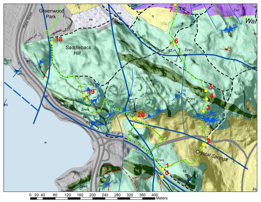
Metamorphic rocks – rocks resulting from exposure of existing rocks to increased temperatures or pressures that
change the mineral composition and arrangement of mineral grains. We say these rocks are metamorphosed.
4. Solid materials (rocks and minerals) have been in existence on Earth for at least 4 billion years. This time in Earth’s
history defines the expanse of geologic time. Geologic time (geologic time scale) is subdivided based on past events
represented by changes preserved in the rock record. Radiometric dating techniques are then used to place precise
numerical ages on rock units and time unit boundaries. A geologic time scale can be found at:
https://www.geosociety.org/documents/gsa/timescale/timescl.pdf.
5. On a geologic map, bedrock is classified into units known as formations, characterized by rock types and age.
Formations have proper names from a place where they are well exposed or first defined. Sometimes, single
formations are split into a sequence of mappable units called members. The boundaries between geologic units are
known as contacts. On geologic maps, formations and members are given their own colors and patterns so they can
be distinguished from each other. They also have abbreviations that consist of a capital letter for the unit’s geologic
time period (when it was formed) and lower-case letters that abbreviate for the unit’s name. For example, “Zsg” = the
Late Proterozoic (Z) Spot Pond Granodiorite (sg). Time period abbreviations in the Fells are Z (Late Proterozoic), P
(Pennsylvanian), and Q (Quaternary). If a rock unit does not have a known age or formal name, only lower-case
letters are used as an abbreviation. (For example: “d” stands for dolerite). Also shown on maps of the Fells are areas
where the geology is concealed by human-made deposits, defined as artificial fill (af).
6. On the geologic maps in this guide, geographic north is shown with an arrow. Compass directions are given in the
guide as degrees W or E of either N or S. For example, N50°E is 50 degrees east of north.
7. Geologic symbols on the maps are used to convey information; for example, on the maps here, the blue lines are
faults. Symbols at stops on the tour are explained, but a complete description of all rock units and a listing of symbols
on the map are given in map explanations at: https://sites.tufts.edu/fellsgeology/
8. The maps in the guide present detailed mapping of the Fells and introduce new formation names. It is an ongoing
research project. Things will likely change with more field work and age determinations. Updates of the bedrock map,
its explanation, and associated surficial geologic map and tours will be posted as they occur. We welcome feedback
at: https://sites.tufts.edu/fellsgeology/.
Crystal Springs Trail in the Middlesex Fells Reservation version: August 30, 2021
Part 1: Crystal Springs, Whip Hill and Saddleback Hill (north of Pond Street)
(Total distance: about 2 miles (~3 km) round trip.)
Prepared by Jack Ridge, Professor, Dept. of Earth and Ocean Sciences, Tufts University
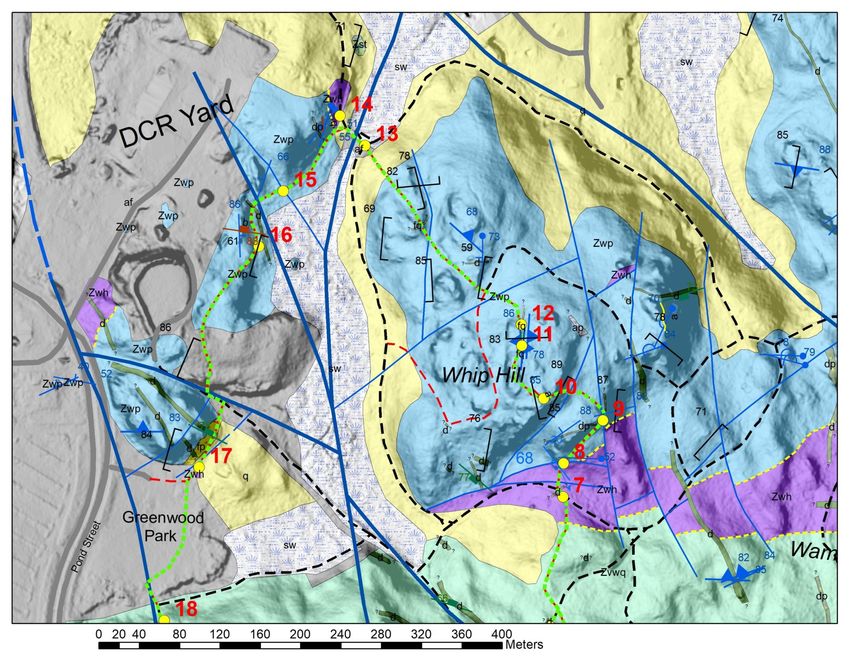
Starting point: Parking Area at Gate no. 42 on the section of Pond Street heading east away from Spot Pond
(see Map CS-1, Stop 0). Head north (across Pond Street) from the parking area. Follow the trail on the
geologic maps as you go. Follow the red trail markers in the field and dashed lime green path on the maps.
On the geologic maps, stops on the tour are marked by yellow circles with red numbers. In the guide below,
trail junction numbers are given that are on the official DCR trail map and are marked with signs in the park.
Alternate parking can be found at Greenwood Park on Pond Street at Stop 17. Have fun!!
This trip focuses on Neoproterozoic metasedimentary rocks of the Westboro Formation, volcanic rocks of
the Wamoset Hill Felsite, and sedimentary rocks of the Whip Hill Formation as well as younger dolerite
dikes. The Neoproterozoic Era is 1000-542 million years ago. The trip will also point out where rocks were
deformed by major faults and fractures and will highlight some glacial features.
NOTE: Polished rock images are cut rock slabs photographed under water. Scale bars are in centimeters.
In pictures of rock surfaces there is often a camera lens cap or rock hammer for scale.
Part 1: Crystal Spring 2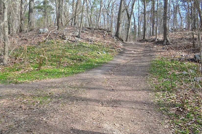
N
                             Map CS-1

    Part 1: Crystal Spring              3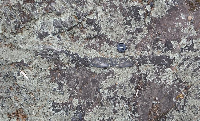
STOP 1: While crossing Pond Street from the parking area at Gate no. 42, you are crossing a major E-W trending fault
that has been rotated slightly clockwise in this area. A fault is nothing more than a fracture separating rocks that have
moved relative to each other. The fault runs through the Westboro Formation (Zvwq), which will be discussed later in
more detail where we can see outcrops (surface exposures) of this formation. The valleys in this area are governed by
the positions of faults. The faults are very complex, with major E-W trending faults cut and offset by major N-S
trending faults. This pattern occurs across the Fells. On Map CS-1, you will see this situation just west of the parking
area, where a large dolerite dike (d) and the E-W trending fault along Pond Street are both offset by a N-S trending
fault. There are also minor faults associated with the two major fault systems. Heavy fracturing occurs along the
faults, causing these rocks to be easily eroded, especially during glaciation. Groundwater is able to seep through the
fractures, leading to the formation of springs and small streams. In some areas, outcrops are scarce due to heavy
fracturing, erosion, and a cover of glacial sediment.
Continue north on the trail across an area where the rock surface is concealed by glacial sediment and descend into
a valley.
STOP 2: In the valley you will arrive at Crystal Spring (image to
right). This slope does not have many outcrops, but it has
scattered boulders of many different rock formations and a
cover of glacial sediment. 30 m before the spring is a large
block (or possibly an outcrop?) of the Westboro Formation
(Zvwq). The spring lies along an E-W trending fault that has
been mapped out based on local topography, particularly the
prominent escarpment (steep slope) to the north. Discharge of
groundwater, or baseflow, forms Crystal Spring and a small
stream, which is active during most seasons. The water at this
spring looks clear, but as far as I know, you should not drink it.
After leaving Crystal Spring the trail heads upslope and
crosses a paved road at junction F2-6. After curving slightly to
the right, the trail ascends the escarpment.

STOP 3: The escarpment is littered with angular fragments of
the Westboro Formation (Zvwq) which is exposed high in the
escarpment (ahead, image to right in early spring). The
Westboro Formation is composed of two interlayered rock
types. One is light gray metasandstone, a hard rock composed
of metamorphosed quartz sandstone and siltstone (q on image
below right). The metasandstone units are fine-grained and
have fractures that may be cleavage (parallel break planes
formed by shearing and recrystallization of the rock) parallel to
what may have originally been bedding. Interlayered with the
metasandstone is dark gray argillite and slate (a on image to
right). The argillite and slate have cleavage planes resulting
from shearing during metamorphism. Argillite is shale, a               q
muddy sedimentary rock, that has been hardened by light
metamorphism while slate is the same rock with cleavage                             a
planes. The cleavage shows up as many closely spaced parallel                                        q
break planes, but it is not well developed. The greenish                                                   a
surfaces on fracture planes are a soft, mica-like mineral called                                                q
chlorite. The rock has undergone regional metamorphism,
which occurs over a large region due to compression by
tectonic forces and heating by burial. The metamorphism here
is relatively light since we can still easily determine the original
rock type from prior to metamorphism, and there has been
relatively little change in the mineral types in the rock unit,
although the mineral grains have changed shape.
Continue to the top of the hill.                                            Part 1: Crystal Spring
                                                                                                                      4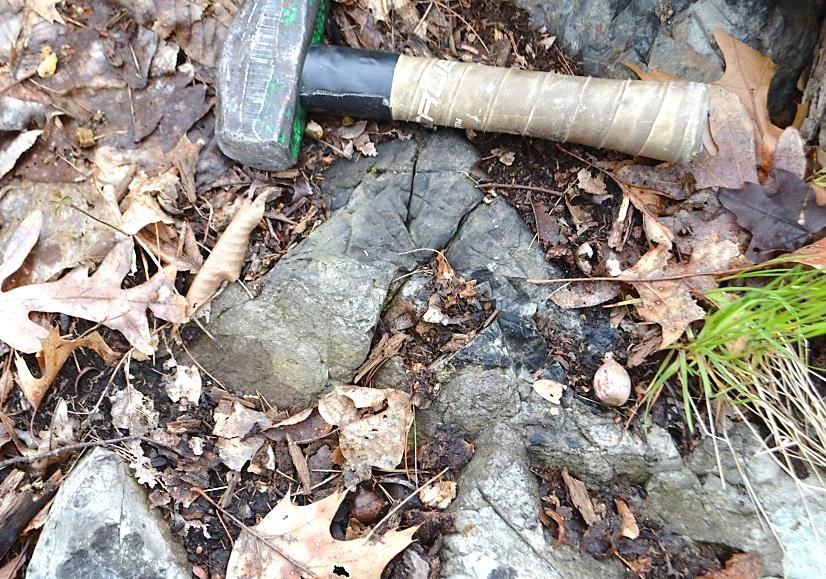
STOP 4: At the top of the escarpment, you will notice a change in the shape of outcrops where the trail crosses a
wide, E-W trending dolerite dike (d). The dolerite is smoother and more rounded (image below left, east (left) side of
trail) than the Westboro Formation (Zvwq) on the slope below. A dike is an intrusion of magma that filled a fracture.
Dolerite is an igneous rock of intermediate grain size made of mafic (dark-colored) minerals and plagioclase feldspar.
Usually, dolerite dikes contain the mafic minerals pyroxene and magnetite. Pyroxene may be partly altered to chlorite
and amphibole, which are both green. In the cut rock sample (image below right), the faintly purple grains are
pyroxene and the gray grains are plagioclase. The high iron content gives the rock a dark color on fresh surfaces and a
rusty appearance on outcrops due to oxidation of iron. Dolerite dikes are common throughout the Fells.

Continue to the far side of the hilltop to where the trail starts to descend.

STOP 5: There is more of the dolerite dike (d) on the hilltop. The north side of the dike is well marked on its west (far)
side by a steep face (image below on left). Then, the trail descends into the Westboro Formation (Zvwq), which is
much harder and less fractured here than in most places (image below on right with light-colored metasandstone
near the hammer). Near the edge of the dike, the Westboro Formation was exposed to very high temperatures, or
baked, when the dike intruded. Baking caused some of the fine clay and mica particles in the argillite to recrystallize,
similar to what happens when clay is fired in a furnace, producing a dense and hard rock called hornfels. This process
is a type of metamorphism called contact metamorphism. It occurs on a very local scale and results from high
temperature exposure near an intrusion, whereas regional metamorphism, which we discussed earlier, was due to
compression and heating on a much larger scale that changed the whole rock formation. Here, the zone of contact
metamorphism is not more than 20 m wide on both sides of the dike. Contact metamorphism can produce different
metamorphic effects in different rocks.

                      d

                                          Zvwq
                                         hornfels

Continue on the trail. After joining Cross Path at junction F2-7, the trail heads west (left), and in about 75 m heads
north (right) into the woods again. Outcrops along this section of the trail are small and scare. In a little more than
100 m, the trail crosses Saddleback Path (also the Heart Healthy Trail) at junction F2-11. From junction F2-11, take
a sharp left and head southwest about 20 m to a mound on Saddleback Trail.

                                                   Part 1: Crystal Spring                                              5
STOP 6: The mound in the trail is hornfels in the Westboro
Formation (Zvwq) along an irregular contact with a NW-SE
trending dolerite dike (image to right). The hornfels is hard
and dolerite has few fractures, so the mound is more                                  d
resistant to erosion. A large quartz vein crosses the contact;
look for the 2-cm-wide, light band that trends E-W across the
outcrop. The quartz vein formed after both of the
surrounding rock formations and was precipitated from
hydrothermal (hot water) solutions that circulated along a
fracture that crossed the contact. The dike was already solid                        Zvwq hornfels
when the vein formed. Note also that the quartz vein is
offset along a small fault (upper right corner of image).
Return to the Crystal Spring Trail at junction F2-11 and continue north (left) to junction F2-12 where the trail crosses
a road.
          Continue the Tour on Map CS-2
STOP 7: At junction F2-12 the trail enters the Wamoset Hill Felsite (Zwh). Felsite is a generic name for any light-
colored (non-mafic) fine-grained igneous rock. The felsite is exposed at the SW corner (left side) of the trail junction
alongside a small NE-SW trending dolerite dike (image below left, view to SW). The dike was deeply weathered along
fractures. Exposures of the felsite over most of its outcrop belt are sparse. The unit is heavily fractured, torn apart by
faults, and is usually both eroded and covered by a thin layer of glacial sediment. The dike is likely responsible for
protecting it from erosion at this site. The Wamoset Hill Felsite is mostly made of rhyolitic pyroclastic rocks. Rhyolite
is a fine-grained igneous rock with the same chemical composition as granite (a coarse igneous rock composed of
quartz with two types of feldspar, plagioclase and alkali). Pyroclastic rocks are composed of volcanic materials that
were airborne before accumulating on the land surface. This may include four components: 1) ash, or fine, broken
glass shards that may have still been molten when they landed; 2) crystals which are mineral grains that had started
to crystallize in the magma prior to eruption; 3) large pieces of glass and pumice (bubbly glass), which may still have
been molten when they landed; and 4) lithic fragments, which are fragments of pre-existing rock, either from prior
volcanic eruptions or any older rocks through which the magma passed in the subsurface. Most of the pyroclastic
units in the Wamoset Hill Felsite are welded tuffs with flattened pumice fragments, abundant plagioclase and quartz
crystals, and lithic fragments. Tuff is a pyroclastic rock partly composed of ash. Welded means that the ash and
pumice fragments were still partly molten when they landed, so they adhered to each other. Molten pumice
fragments became flattened as material accumulated on top of them. Unlike most of the Wamoset Hill the rock here
is a rhyolitic lava flow. Close examination of the east (uphill) end of the outcrop (image below right) will show flow
banding and small cumulophyric plagioclase clusters. Flow banding was produced by the flow of lava that had slight
differences in composition, oxidation, or crystal sizes and has swirls of parallel layers, like marble cake. Cumulophyric
crystals are delicate clusters of intergrown crystals, in this case plagioclase, with well formed crystal shapes within
finer material (white specks, image below right). The lava would have been very viscous (sticky), molten rhyolitic glass
(obsidian) with a few crystals. Glass in lava and welded tuff is not stable over geologic time and, after solidification,
the glass crystallizes, or devitrifies, to very fine quartz and feldspar. The Wamoset Hill Felsite has a radiometric age of
596 million yr (obtained by Francis Macdonald at UC Santa Barbara). The age of the Wamoset Hill Felsite was
determined by the measurement of uranium and lead isotope ratios in tiny zircon (zirconium silicate) crystals in the
rock. With time, uranium decays to lead and the ratios change, allowing for an age calculation. - For more on how
rock ages are determined see: RockAges.

                    Zwh                             d

                                                   Part 1: Crystal Spring                                               6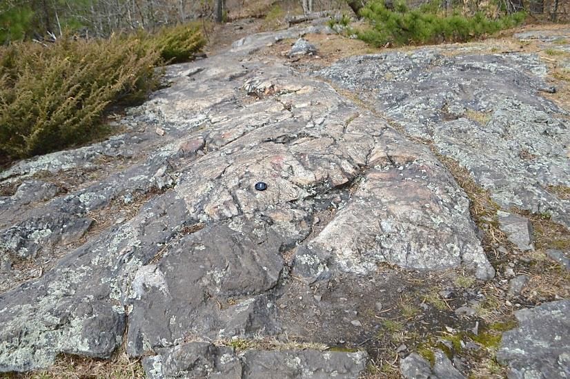
N
                             Map CS-2

                                        7
    Part 1: Crystal Spring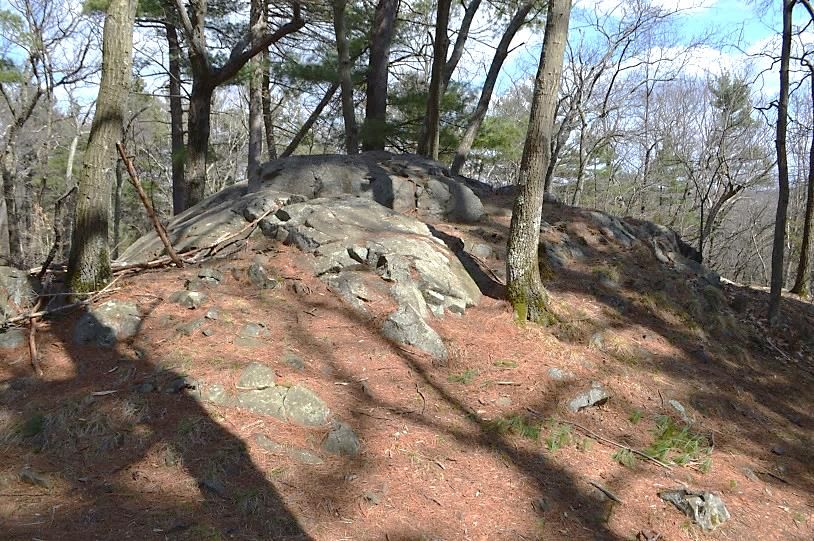
STOP 8: After a brief turn to the west (left), the trail
continues north (right) toward Whip Hill. After crossing a
small valley, the base of the far hill shows the contact of
the Wamoset Hill Felsite (Zwh) and the Whip Hill
Formation (Zwp). At this location, the contact occurs
                                                                                             Zwp
along a minor fault, but in other areas, the Whip Hill                                                                fault
appears to rest on an unconformity on the Wamoset Hill
Felsite, meaning that the Whip Hill Formation is younger.                              Zwh
The unconformity here represents an erosional surface
on the Wamoset Hill that was later covered by sediment
from the Whip Hill Formation. The Whip Hill is described
more fully a few stops from here. For more on
unconformities see: Unconformities. The Wamoset Hill
at this location is a welded crystal tuff and is highly
fractured in the valley below, where there is a major fault. The low, irregular terrain to the east has more exposures
of the volcanic rocks.
                                         STOP 9: A short distance up the hill, the trail passes a bending dolerite dike (d).
                                         The dike is about 1.5-2 m wide, starts as E-W trending on the east (left) side of
                                         the trail (image to left) and then bends to follow the trail north (image below,
                                         view north). The dike is porphyritic in places, meaning that the fine-grained
                                         dolerite has a set of distinctively coarser crystals in it. The crystals are elongate,
                                         white plagioclase up to 5 mm long.
                             Zwp
                d
   Zwp

                                                                 Zwp

                                                                                           d              Zwp

The trail bends to the west (left), leaves the dike, and heads toward the top of the hill. The trail then crosses a
small N-S trending fault that follows a ravine to the south (left). Continue to the top of Whip Hill.

STOP 10: Just where the trail arrives at the top of
Whip Hill and begins to pass through some cedar
trees, the Whip Hill Formation (Zwp) is intruded by a
thin (~5 cm wide) rhyolite dike. This dike is difficult to
see because of lichen cover (image to right, arrow).
Dikes of this type, which are mostly wider than this
one, are common across the top of Whip Hill. The top
surface of the dike is higher than the surrounding
Whip Hill Formation, which has weathered more
rapidly. The top surface of the dike is highly polished
and has fine glacial striations oriented at S30°E. The
striations indicate the direction in which ice during the
last glaciation slid across the top of the hill.

Continue on the trail north for another 40-50 m to the highest point of Whip Hill.

                                                     Part 1: Crystal Spring                                                  8
STOP 11: The high point is a good place to see some of the internal structures of the Whip Hill Formation (Zwp).
Within the Whip Hill are large blocks of light gray quartz sandstone surrounded by rusty, dark gray mudstone (image
below left). The sandstone blocks do not have sharp or flat boundaries and sometimes display pinched ends,
indicating that they were soft when they were deposited in the mudstone (image below right). The sandstone masses
are sometimes very large, up to many meters across. The mudstone either has no distinct bedding or it has well
preserved thin bedding that may contain sandy layers. The Whip Hill is mostly made of what were originally poorly or
non-cemented sandstone blocks in muddy debris flows formed along an ancient continental margin where they slid
into deeper water. A key thing to observe here is that, although the unit shows deformed sediment, it was sediment
that was deformed when it was soft and was not solid rock deformed by regional metamorphism. Unlike the
Westboro Formation, it does not have signs of metamorphism, such as cleavage, except where it is deformed along
faults or baked next to dikes.

Continue to the north end of the hilltop where the
slope starts to descend.
STOP 12: At this point is one of the strangest rock units
in the Fells (image on right). At first this looks like a
slightly rusty sandstone unit. However, close
examination reveals rounded grains up to 3 mm in
diameter. Viewed in a microscope the rock has a
puzzling texture but is clearly igneous. This is a rhyolite
dike with rounded crystals of quartz and feldspar in
surrounding finely intergrown quartz and feldspar
(image below right). The rounded grains are crystals
picked up by the magma from a light-colored, coarse
igneous rock unit. After the crystals were incorporated
into the magma, they started to get absorbed by
melting, leading to their round shapes. The dike presents
another puzzle in that it has pinched ends as though it
was molten when the surrounding sediment deformed
as a debris flow. A third surprise is the presence of small
fluorite (calcium fluoride) crystals in the dike. These are
clearly seen in a microscope, but you may be able to see
them on the outcrop as small (1 mm or less) square
crystals with red to brown oxide coatings (image to
right).
Follow the trail down hill, it crosses a trail at junction
F2-1. Continuing northwest the trail descends Whip Hill
through some knobs of quartz sandstone and arrives at Whip Hill Path at junction E2-10. The trail then crosses a
wetland.
STOP 13: The wetland sits on a major fault zone that displaces rocks on opposite sides of the valley (no image). Rocks in
the valley are heavily fractured and were eroded faster than adjacent rocks. The true displacement direction on the fault
zone remains uncertain because there is no way to gage vertical movement that may have occurred.
                                                 Part 1: Crystal Spring                                            9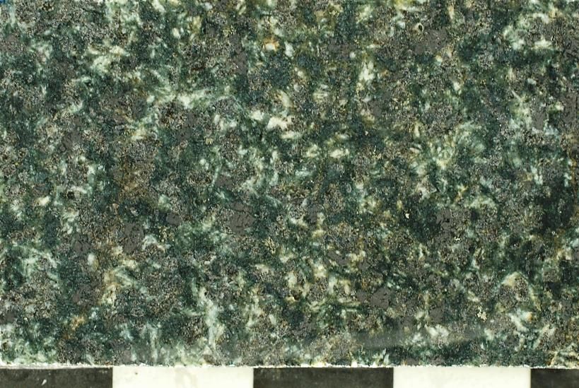
STOP 14: When the trail reaches the far side of the valley at junction E1-2 it faces a hill slope (image below left) that
has the contact of the Whip Hill Formation (Zwp) and the Wamoset Hill Felsite (Zwh). The felsite here is a volcanic
breccia or conglomerate which is pebble-sized pieces of volcanic rock in a finer matrix of ash, crystals and sand-sized
particles (image below right). It remains uncertain whether this is a coarse lithic tuff (i.e., pyroclastic) or whether this
is a sedimentary rock (conglomerate) composed of reworked volcanic materials. The Whip Hill unit above has bedding
that parallels the contact between the two formations and dips to the west-northwest. It also has small crossbeds
(beds within a thicker bed that dip from the top to bottom of the thicker bed) that indicate that the rock formation is
right side up (center of image on bottom right at arrow). The contact appears to be an unconformity representing an
erosion surface, but the potential existence of a steep fault here between the two units has not been eliminated.

            Zwp

                                  Zwh

After heading south (left) at junction E1-2 the trail
comes to a wooden walkway over a wet area.

STOP 15: On the map you will see that at the wet area
the trail crosses two slots. The first slot is a minor fault
and the second is a major fault, both displacing the
Whip Hill Formation (Zwp). The second slot has a fault
with very significant displacement but just how much is
unknown because it has not been possible to assess
vertical movement on this fault. It splits away from the
fault zone beneath the large wetland to the east.

Continue on the trail about 100 m.

STOP 16: The trail passes a ledge of light gray deformed
sandstone in the Whip Hill Formation (Zwp, image to
right). The rock here is highly sheared and deformed
along the fault from the second slot at Stop 15.

Continue up an incline to the south. Just before
entering the large artificial fill deposit (af, see map CS-
1B) the trail crosses another outcrop of sandstone.
After crossing the artificial fill area, the trail descends
to Whip Hill Road at junction E2-1. Follow Whip Hill
Road southeast (left) for 25 m. At this point turn
southwest (right) where the trail cuts away from the
road toward Greenwood Park (playground area).

                                                     Part 1: Crystal Spring                                             10
STOP 17: Just before the opening in the stone wall at
Greenwood Park there are some highly fractured and
scattered outcrops of the Wamoset Hill Felsite (Zwh,
image to right). This formation underlies the low area of
the park beneath the artificial fill and likely the Stone Zoo
across Pond Street. Outcrops of this formation are poor
because it is highly fractured, and it was easily eroded
during glaciation.
At the base of the steep slope to the north (right) with
lightly baked Whip Hill Formation (Zwp) above it (image
to right below) is a rhyolite dike (fp) that is barely
exposed. At the base of the slope is likely an E-W
trending fault like at Stop 8, but without outcrops and
visible displacements it has not been possible to precisely
map this fault which is shown as a dashed blue line on
the map. Zwp
After entering the playground area and at the
southern end of the wall, you will see a few large volcanic
boulders that were cleared to make the park. The wall is
made of many boulders from dolerite dikes and coarse
rocks from the Spot Pond Granodiorite that do not occur
here and were brought in for construction of the wall.
fp
Continue the Tour on Map CS-1
Cross the playing fields to the forested area south of
Greenwood Park and the base of Saddleback Hill at
junction E2-2.
STOP 18: At the base of Saddleback Hill is a badly
shattered outcrop of the Westboro Formation (Zvwq)
that is mostly fractured argillite (image to right).
Scattered about are boulders from the Wamoset Hill Zvwq
Felsite, dropped off by southward moving glacial ice.
These boulders are true glacial erratics since they are
on a different bedrock unit than the one from which
they are derived. junction E2-2
The tour continues south up Saddleback Hill and
passes junction E2-3 to E2-4. Take a right (west) at E2-
4, which takes you to the top of a steep hill
overlooking Spot Pond and Pond Street to the west.
STOP 19: At the top of the hill is a view west through the
trees to Spot Pond and below is Pond Street. The trail
follows the contact of the west side of a 5-m wide
dolerite dike (d) and the Westboro Formation (Zvwq,
image to the right). The Westboro is baked in this area
and does not show fractures and cleavage very well. The Zvwq
N-S trending dike has large (up to 1 cm) vesicles (gas
bubbles). The best view of Spot Pond is 10-15 m west (to
right) of the hillcrest shown on the image. Beneath this d
hill on Pond Street is a long exposure of the Westboro
Formation that is easily seen driving along Pond Street
(panoramic view, top of next page).
The trail follows the dike before descending to the west
(right) downslope and eventually circling around to the
east side of the hill and rejoining Saddleback Path at
junction E2-5.
Part 1: Crystal Spring 11Panoramic view of Westboro Formation outcrop along Pond Street below Stop 19. This is a view to the east from the
sidewalk along Spot Pond. This rock exposure has deformed zones with calcium-magnesium silicate minerals including
the minerals tremolite, diopside, zoisite, and calcite. The rock units were likely a sedimentary rock sequence of
sandstone and mudstone that had an appreciable amount of magnesium and calcium carbonate minerals.
Take a right at junction E2-5 on Saddleback Path
heading southeast down Saddleback Hill. At
junction F2-4 a small trail branches east (left) and
Saddleback Path continues south.
STOP 20: Above on the steep slope of Saddleback
Hill the metasandstone and argillite in the
Westboro Formation (Zvwq) are highly deformed.
Metasandstone layers have been pulled apart into
pods. The image to the right is from the steep face
to the north. (I don’t advise going up there). Note
the pinched ends of the metasandstone pods and
the subtle cleavage developed parallel to original
bedding in the surrounding argillite. Cleavage
planes here dip steeply to the north.
To get back to the parking lot where this guide started, either:
1) continue south on Saddleback Path to the sidewalk on the north side of Pond Street. The sidewalk will take
you east (left) past Gate no. 41 to where the Crystal Springs Trail crosses Pond Street, or alternatively,
2) follow the small trail at junction F2-4, which heads southeast to Crystal Spring Road at junction F2-5. Follow
this road south (to right) to the sidewalk along Pond Street at Gate no. 41 and head east (left) to the Crystal
Spring Trail.
The parking lot at the start of the tour is across Pond Street from the Crystal Spring Trail at Gate no. 42. Part 2 of
tours in this area (Virginia Wood Tour), on the combined Virginia Wood and Spot Pond Brook Historic Trails, begins
at this parking lot heading southwest as described in the Virginia Wood (Part 2) guide.
Here are more detailed explanation of some things discussed on the Crystal Springs tour:
For more on how plutons form see: Plutons.
For more on how rock ages are determined see: RockAges.
For more on unconformities see: Unconformities.
Part 1: Crystal Spring 12You can also read