South Shore of Long Island, New York Regional Sediment Management Investigation: An Overview of Challenges and Opportunities
←
→
Page content transcription
If your browser does not render page correctly, please read the page content below

ERDC/TN RSM-22-1
                                                                                             April 2022

                  South Shore of Long Island, New York Regional
                        Sediment Management Investigation: An
                      Overview of Challenges and Opportunities
                                   by Anna M. Jansson, Arun K. Heer, Suzana S. Rice,
                           Frank Buonaiuto, Danielle M. Tommaso, Lynn M. Bocamazo,
                                             Stephen A. Couch, and Jodi M. McDonald

PURPOSE: The US Army Corps of Engineers (USACE) is conducting the “South Shore of Long
Island, New York Regional Sediment Management Investigation” to further understand sediment
dynamics and to develop a comprehensive regional sediment management plan for the south shore
of Long Island, New York. Regional sediment management is a systems approach using best
management practices for more efficient and effective use of sediments in coastal, estuarine, and
inland environments. This investigation seeks to characterize sediment movement on the south
shore of Long Island as a holistic system across the entire study area. It focuses on the regional
system post-Hurricane Sandy (October 2012) as the storm significantly altered the physical
landscape with severe shoreline erosion, which resulted in the construction of projects to reduce
the risk of future storms and stakeholder priorities with a new emphasis on bay-side sediment
dynamics, such as channel shoaling and disappearing wetlands. Despite the fact the storm caused
severe erosion, the equilibrium beach profile, depth of closure, and general shoreline orientation
seem to be unaffected.

Previous studies have characterized sediment movement at specific sections of the south shore, but
these data have not been incorporated to create a system-wide perspective. Coordinating sediment
management across the six Atlantic Ocean inlets, Great South Bay Channel, Intracoastal Waterway,
and coastal storm risk management (CSRM) projects could save the federal government millions
of dollars in dredging and sand placement actions. This technical note presents the progress the
investigation has made to date and will be followed with a more in-depth technical report titled
South Shore of Long Island, New York Regional Sediment Management Investigation: A Post-
Hurricane Sandy Shoreline Evaluation, currently in preparation.

REGIONAL OVERVIEW: Both the longest and the largest island in the contiguous United
States, Long Island extends 125 miles eastward from New York Harbor (New York City) to
Montauk Point (Suffolk County). The south shore of Long Island is geographically diverse and
includes barrier islands, headlands, bays, coastal plains, and urban, suburban, and rural areas. It is
densely developed with large federal investments in navigation channels, CSRM projects, and
ecosystem restoration projects. Sediment here is a valuable resource; it is used for CSRM, erosion
control, and habitat restoration. A diverse group of stakeholders, including federal agencies, New
York State, New York City, Nassau County, Suffolk County, local towns, villages, academic
institutions, and non-profit organizations, have expressed the need for coordinated, thoughtful
sediment management to maximize the use of sediment for these purposes.

                            Regional Sediment Management: Integrated
                            Solutions for Sediment Related Challenges
                           Approved for public release; distribution is unlimited.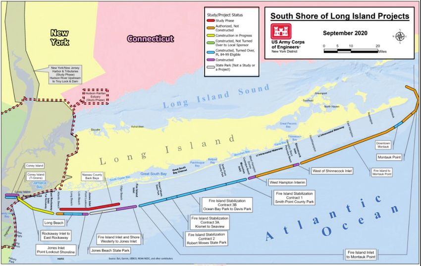
ERDC/TN RSM-22-1
April 2022

Most sediment used for federal and local CSRM and ecosystem projects is dredged from federal
and local navigation channels and offshore borrow sites. USACE has been an instrumental player
in the movement and management of sediment in the system since the early twentieth century, as it
maintains eight regionally important federal navigation channels. Individual USACE navigation
and CSRM projects have analyzed sediment needs in specific areas on the south shore, but a
compilation of existing studies along the entire south shore of Long Island has yet to be completed.
The region could benefit from an overarching regional sediment management plan.

EXISTING CONDITIONS

South Shore of Long Island Sediment Dynamics. There has been a long history of scientific
study on the continental shelf south of Long Island. Relative to the rest of the mid-Atlantic and
southeastern US coasts, the Long Island continental shelf is sediment rich. The shelf south of Long
Island covers approximately 21,044 km2 (5.2 million acres), but only a fraction of it is within the
reach of present-day dredging technology. Only sediment within 30 m * of the water surface is
currently reachable. Sediments within this depth range cover 2,630 km2 (650 acres) (Bokuniewicz
and Tanski 2010). Based on sediment samples by Foster et al. (1999), we can expect that there are
7.6 billion m3 of sand (99% sand with 1% other clast sizes) to be accessible on the shelf. On average,
sand dredged from inlets alone amounts to approximately 1.0 million m3 per year (Bokuniewicz and
Tanski 2010). In the future, this study will seek to update these quantities.

Erosion of the bluffs at Montauk Point has been shown, at least partially, to contribute to the sand
on the beach farther west (Williams and Morgan 1988). Separate studies suggest that anywhere
between 6,100 m3 (Bokuniewicz 1999) and 110,000 m3 (Kana 1995) of sand could be delivered
annually by bluff erosion of the Montauk bluffs. A more recent study published in 2005 by
Buonaiuto and Bokuniewicz indicates the total sediment supply is 34,500 m3 per year with 21,700 m3
per year being beach suitable. The balance of the sediment is thought to come from longshore
transport from the east, stream input, the reworking of glacial outwash sand, the reworking of tidal
ebb shoals, and onshore transport along shoreface-attached sand ridges. Panuzio (1969) and Rosati
et al. (1999) indicated that the apparent deficit in their budgets could be explained by various factors
including updrift beach nourishment and erosion as well as the uncertainty in the data. Especially as
sea level rises, sand will be added to the littoral system by the excavation of the outwash plain and
reworking of relic glacial overwash lobes or stranded flood tidal shoals.

There is geologic evidence that sand is being transported into the system from beyond the surf
zone. Offshore sources of sand have long been hypothesized to account for the apparent increases
in the longshore transport rates at Fire Island Inlet. William (1976) suggested offshore glacial
outwash lobes as a source of littoral material. Kana (1995), however, proposed that relict ebb
tidal shoals contributed to the beach system, arguing an offshore source may be needed to support
spit growth at the terminus of Fire Island (Democrat Point). Historically, Fire Island has been
migrating westward since 1834, leaving trailing ebb shoals that have been estimated to contain
between 31 million m3 (Moffatt and Nichol 2009) and 38 million m3 (Walton and Adams 1976)
of sand. The eventual stranding of ebb shoals, as inlets migrate westward and sea level rises, has
been postulated to be the origin of oblique ridges (McBride and Moslow 1991). Sand from the

*
 For a full list of the spelled-out forms of the units of measure used in this document, please refer to US
Government Publishing Office Style Manual, 31st ed. (Washington, DC: US Government Publishing Office 2016),
248-52, https://www.govinfo.gov/content/pkg/GPO-STYLEMANUAL-2016/pdf/GPO-STYLEMANUAL-2016.pdf.
                                                                   2
    US Army Corps of Engineers • Engineer Research and Development Center
ERDC/TN RSM-22-1
                                                                                                     April 2022

inner shelf also contributes to south shore Long Island beaches. It is unknown how much onshore
sediment transport supplies the south shore of Long Island sediment budget.

The topography of the Middle Atlantic Continental Shelf both in New York and New Jersey is
dominated by the shore-subparallel ridges and swales, approximately northwest to southeast in
orientation (e.g., Stubblefield et al. 1984; Swift et al. 1979. They are superimposed on large-scale,
shoal-retreat massifs left by the Holocene transgression (e.g., Stubblefield and Swift 1976). The
ridges are composed of very well to moderately sorted, medium to fine sand, compatible with
beach-type sand found along the south shore (e.g., William 1976). The origin of these features has
been the topic of considerable debate. Several lines of evidence suggest the oblique sand ridges
have relic origins, as ridges from paleo (sub-aerial) drainage (McKinney and Friedman 1970),
abandoned ebb shoals (McBride and Moslow 1991), relic barrier islands (Stubblefield et al. 1984),
or drowned shorelines or drowned shoal-retreat massifs (e.g., Swift et al. 1979). Based on
radiocarbon dating of shells recovered in cores on the ridges, it appears the shelf ridges evolved
between 8,000 and 14,000 years BP during one of the sea level still-stands (Stubblefield et al.
1983). The understanding of the sand ridges’ origins, the processes that maintain them, and their
potential role in onshore transport of material is poor. Incomplete knowledge regarding sediment
transport and the interactions between the shelf and nearshore system pose significant challenges
in managing and possibly utilizing this resource. If there is onshore transport, the use of sand from
offshore borrow areas for beach nourishment could be accelerating the natural process, akin to
sand bypassing at inlets. However, artificial manipulation of the system could alter the rates of
transport and, to a certain extent, the specific pathways possibly causing unforeseen impacts
(Bokuniewicz and Tanski 2010).

Federal Navigation Channels. The south shore of Long Island includes eight federal
navigation channels: Jamaica Bay (Rockaway Inlet), East Rockaway Inlet, Jones Inlet, Fire Island
Inlet, Moriches Inlet, Shinnecock Inlet, the South Bay Channel, and the Long Island Intracoastal
Waterway (Figure 1). All the on-going inlet channel dredging and sand placement activities serve
to bypass sediment.

USACE Civil Works Studies and Projects. Constructed USACE CSRM projects on the south
shore of Long Island include Coney Island; Coney Island T-Groins; Rockaway Inlet to East
Rockaway Inlet; Plumb Beach, Jones Inlet Point Lookout Shoreline; Fire Island Inlet and Shore
Westerly to Jones Inlet; sections of Fire Island Interim Stabilization; Long Beach, Westhampton
Interim project, West of Shinnecock Inlet; and Downtown Montauk (Figure 2). Additionally, Jones
Inlet to East Rockaway Inlet (Long Beach) project and the balance of the Fire Island Interim
Stabilization project are currently under construction.

                                                   3
                                            US Army Corps of Engineers • Engineer Research and Development Center
ERDC/TN RSM-22-1
April 2022
Figure 1. Federal navigation channels on the south shore of Long Island.
4
US Army Corps of Engineers • Engineer Research and Development CenterERDC/TN RSM-22-1
April 2022
Figure 2. USACE projects on the south shore of Long Island.
5
US Army Corps of Engineers • Engineer Research and Development CenterERDC/TN RSM-22-1
April 2022
There are three ongoing USACE feasibility studies in the region that recommend the construction
of projects within the next 15 years. These in-progress studies include Hudson Raritan Estuary, East
Rockaway Inlet to Rockaway Inlet, and Fire Island to Montauk Point. There are two additional
USACE studies planned that may recommend CSRM features on the south shore: New York-New
Jersey Harbors and Tributaries and Nassau County Back Bays. These studies are still in the early
formulation stages, so their final recommendations are unknown currently.
Hurricane Sandy: Effects and USACE Response. Hurricane Sandy devastated the region
in October 2012. This event caused major erosion that resulted in three breaches through Fire
Island at the eastern end of Great South Bay in the areas of Old Inlet, Smith Point, and Moriches
Inlet. Two breaches were quickly filled in and repaired, and one breach in the Wilderness Area of
Fire Island National Seashore (Old Inlet), remains open to the Atlantic Ocean (New York Sea
Grant 2016).
USACE undertook emergency PL 84-99 response actions immediately after Hurricane Sandy,
and since their completion, USACE has constructed several additional CSRM projects in the
region. It was emphasized during planning and construction of these projects that their future
renourishment needs may not be met by current sediment sources. The problem is not just
technical in nature but is also complicated by permitting, jurisdictional, and funding challenges
regarding sediment resources.
CURRENT PROJECTS AND PRACTICES: Presently, the eight federal navigation channels
are dredged periodically by USACE. The actual post-Hurricane Sandy maintenance is as follows:
Jamaica Bay (Rockaway Inlet) has historically been dredged every 3–5 years, and the sand has
been placed in the Historic Area Remediation Site (HARS) located approximately 3.5 nautical
miles east of Sandy Hook, New Jersey, and 7.7 nautical miles south of Rockaway, New York, or
on the nearby adjacent beaches. East Rockaway Inlet has been dredged every 2 – 5 years, and the
sand has been placed at Far Rockaway Beach. Jones Inlet has been dredged every 7 – 12 years
with its sand placed in Point Lookout. Fire Island Inlet has been dredged every 4 – 5 years, and
the sand has been placed at Gilgo Beach. Moriches Inlet has been dredged every 6 years, and the
sand has been placed on Fire Island at Smith Point County Park. Shinnecock Inlet has been dredged
every 3 – 6 years with its sand placed at Poquogue Beach. The Great South Bay Channel has
historically been dredged every 6 – 39 years, and the sand has been placed at Robert Moses State
Park. The Long Island Intracoastal Waterway has typically been dredged every 2 – 9 years, and
the sand has been placed in Smith Point County Park or Cupsogue Beach County Park. The historic
dredge frequencies are often less than their authorized dredge frequency, which is what is needed
to maintain navigation in the channel. The channels need to be dredged more frequently than they
are, but funding is the limiting variable. Table 1 summarizes dredging frequency and sand
placement areas for the federal navigation channels.
6
US Army Corps of Engineers • Engineer Research and Development CenterERDC/TN RSM-22-1
April 2022
Table 1. Dredge frequency and sand placement areas for each federal navigation channel
on the South Shore of Long Island.
Observed Dredge Authorized Dredge
Inlet/Channel Name Frequency Sand Placement Area Frequency
Jamaica Bay (Rockaway Inlet) 3 – 5 years HARS 2 years
East Rockaway Inlet 2 – 5 years Far Rockaway Beach 2 years
Jones Inlet 7 – 12 years Point Lookout 3-5 years
Fire Island Inlet 4 – 5 years Gilgo Beach 2 years
Fire Island/Smith Point County
Moriches Inlet 6 years Park 1 year
Shinnecock Inlet 3 – 6 years Poquogue Beach 2 years
Great South Bay Channel 6 – 39 years Robert Moses State Park Unspecified
Smith Point County Park or
Long Island Intracoastal Waterway 2 – 9 years Cupsogue Beach County Park Unspecified
PREVIOUS USACE INVESTIGATIONS: As part of this Regional Sediment Management
(RSM) sponsored investigation, the Project Delivery Team (PDT) conducted a literature search of
existing reports to understand the history of sediment management in the region and the problems
that have been studied and addressed. The following is a summary of known information produced
by USACE. Other agencies and institutions have completed similar studies, which are being used
as part of the investigation but are not listed here for brevity.
In 2011, the USACE New York District carried out an RSM investigation for East Rockaway Inlet
that utilized the USACE Coastal Modeling System. This investigation addressed that dredging data
at that time showed that the shoaling rate of the East Rockaway Inlet was increasing.
Hydrodynamic and sediment transport models showed that the shoal/inlet system is supplied by
sand from a variety of sources, including longshore transport from the east; onshore transport
during storm wave conditions; reworked material from the ebb shoal on the west side that
circulates around to re-enter the system through the seaward edge of the ebb shoal; longshore
transport from the west; and transport into the system from the bay area. Sediment transport from
the west and the bay system is relatively weak compared to the other three sources. The
investigation recommended a deposition basin that would accumulate approximately 76,455 m3 of
sediment annually that could be used for periodic nourishment. This deposition basin would
provide a reliable borrow source for periodic nourishment while enhancing the natural bypassing
and reduce net loss of the regional sediment.
In 2015, the USACE New York District conducted a re-analysis of the Long Beach Island
Feasibility Study that was originally conducted in 1995. Based on the results of circulation and
sediment transport modeling during the reanalysis, the recommended plan consisted of seven
groins combined with beach fill.
Since the 1950s, the USACE New York District has been executing the Fire Island to Montauk
Point Storm Damage Reduction Study. In 2007, a reformulation effort began on inlet
modifications. The vision for the Fire Island to Montauk Point Reformulation Study is to prepare
an implementable, comprehensive, and long-term regional strategy for the 133 km portion of the
south shore of Suffolk County, Long Island, New York, that will reduce risks to human life and
property while maintaining, enhancing, and restoring ecosystem integrity and coastal biodiversity.
The Recommended Plan includes a combination of (1) inlet modifications (continuation of
7
US Army Corps of Engineers • Engineer Research and Development CenterERDC/TN RSM-22-1
April 2022
authorized navigation projects, dredging, downdrift placement of dredged material, placement of
dune and berm, and monitoring); (2) non-structural measures (primarily building retrofits, with
limited relocations and buy-outs); (3) breach response for barrier islands; (4) beach and dune fill
with renourishment: up to 30 years, approximately every 4 years; (5) sediment management;
(6) groin modifications; (7) coastal process features; (8) adaptive management; and (9) integration
of local land use regulations and management.
From 2006 to 2010, the USACE New York District conducted an RSM investigation called the
Long Island Coastal Planning Project. The purpose of this project was to recommend ways to
broaden the New York District RSM Program. The congressional direction was to (1) collect and
inventory sediment resources and related coastal process data, (2) identify gaps in data, (3) develop
a regional sediment budget, and (4) develop an inventory of existing sediment borrow areas. The
study produced a draft white paper on sediment resources and related coastal processes
(Bokuniewicz and Tanski 2010), developed a Cascade model (inlet morphology) for the Fire Island
to Montauk Point project, inventoried existing sediment borrow areas, compiled existing inlet and
shoreline sediment budgets, conducted sediment monitoring at Jones Inlet, and further developed
the Long Island Sediment Needs Assessment database.
PROBLEMS AND NEEDS: Sustainable sediment management on the south shore of Long Island
is complex. There is a need to re-envision traditional sediment management in the region due to cost
and a lack of usable sand for an array of purposes. This was underscored by the recent literature
search as well as a May 2019 stakeholder meeting held in Mineola, NY (USACE NAN 2019). The
meeting was attended by federal, state, and local agencies as well as academic institutions.
Specifically, the problems affecting USACE are that the inlets are not dredged as frequently as
needed and there is not enough sand for ongoing USACE beach nourishment projects.
USACE Projects. Some longstanding problems identified by local stakeholders at the federal
navigation channels of Shinnecock, Moriches, and Fire Island Inlet include navigation reliability,
beach erosion immediately downdrift of the inlets, and erosion of the beach west of the ebb-shoal
reattachment (USACE NAN 2019). Another need emphasized at the stakeholder meeting is more
frequent dredging of federal and local inlets and channels. According to stakeholders, current
maintenance practices dredge less frequently than what is required to keep the inlets navigable.
The Fire Island ferries transiting the Great South Bay are affected by shoaled-in channels. This is
particularly a problem for stakeholders at Jones Inlet (USACE NAN 2019). Many CSRM projects
and recreational beaches will require sand resources in the future. USACE is looking for the most
cost-effective method to meet ongoing and future project needs.
Additional Needs. An important finding that came out of the May 2019 stakeholder meeting is
that sediment is needed for different reasons on the ocean side than on the bay side. On the ocean
side, the sediment is needed for coastal storm risk management to maintain barrier islands. The
barrier islands act as a buffer against storm surges for mainland Long Island, protecting the dense
residential areas there from coastal storms. More people live on the western barrier islands (Long
Beach, Rockaway, and Coney Island) than the eastern barrier islands. Sediment on the barrier
island beach acts as a coastal storm risk management feature for the buildings on the barrier
islands. Storm waves erode the barrier islands, and if enough sand is removed, buildings become
endangered by wave attack, inundation, and storm-induced erosion.
8
US Army Corps of Engineers • Engineer Research and Development CenterERDC/TN RSM-22-1
April 2022
Conversely, on the bay side, sediment is needed for ecological restoration and health. The western
end of the bay side historically had marsh islands that were important habitat for native plants and
animals. For at least 100 years these marsh islands have been eroding. The marsh islands have
been reducing in size, thus losing critical habitat in this densely developed area (USACE NAN
2019). More sediment is needed to replace the sand that is lost on the marsh islands. It is not fully
understood why the marsh islands are eroding, but one hypothesis is that the navigation channels
in the bays increase water velocity during tidal flow; the higher tidal velocity may erode sediments
on the marsh islands and carry them away (USACE NAN 2019). Another hypothesis is that the
inland sediment source for the bays (the streams that drain Long Island) have been almost
completely halted by development on the western end of Long Island (USACE NAN 2019). Most
of the ground surface in this area has been paved over, and runoff is discharged directly into the
bay from storm sewers without being able to pick up any sediment along the way. The need for
more sediment is complicated by the related, but opposite, need to dredge the bay channels more
frequently. The local channels in this area have filled in substantially since Hurricane Sandy,
making them difficult to navigate. Several stakeholders voiced this need to dredge the bay channels
at the meeting.
Further Study. The PDT learned that the stakeholder community is greatly interested in sediment
management in the bays on the south shore of Long Island (USACE NAN 2019). This RSM
investigation, along with most previous USACE investigations, focuses on the Atlantic Ocean side
of the barrier islands on the south shore. The May 2019 stakeholder meeting participants voiced that
many studies have been completed for the ocean side of the barrier islands but relatively very little
has been done to understand sediment management on the bay side (USACE NAN 2019).
Undertaking a regional sediment management investigation of the bays is not within the scope of
this investigation. The stakeholders are keenly interested in this topic, so the bays of the south shore
of Long Island may be a good subject for future RSM investigation.
OPPORUNITIES: This study can address the actual dredge frequency needs of federal
channels, locate more sediment sources for ongoing USACE beach nourishment projects, and
address competing needs for sediment in the study area. One aspect of this could be to implement
a strategic monitoring plan. The purpose of this would be to observe and record how sediment
moves through the system once it is placed on the beach. Currently, after-placement surveys are
conducted after dredging, but there is no mechanism to monitor how the placed sand behaves
outside of current project areas. Also, this investigation could identify areas for the beneficial
use of dredged materials from the inlets. The marsh islands need sediment, and the federal
navigation inlets need to be dredged. Additionally, data management plan and collaboration with
local stakeholders is also needed.
Another opportunity could be to update the region’s GenCade model. GenCade is a combination
of the GENESIS and Cascade models. It calculates shoreline change, wave-induced long-shore
sand transport, and morphology change at inlets on a local to regional scale and can be applied as
a planning or engineering tool (Frey et al. 2012). The study area has an existing model, but it has
not been updated in more than a decade. The New York District could use this model to predict
sediment movement once it is updated to reflect the current post-Hurricane Sandy conditions of
the region. Other numerical models may be used as part of the investigation as appropriate.
9
US Army Corps of Engineers • Engineer Research and Development CenterERDC/TN RSM-22-1
April 2022
CONSTRAINTS: Any changes in federal navigation channels will need congressional
authorization before the changes can occur. Any recommendation from this investigation that
involves changing the size or depth of federal navigation channels will require a feasibility report
and environmental assessment or environmental impact statement and chief’s report for
congressional authorization.
This investigation does not have authority to recommend dredging of locally owned navigation
channels in the bays, but during the stakeholder meeting, concerns about municipalities being able
to do this type of dredging were raised. Local municipalities could partner with USACE to do a
Section 204 CAP project to address these sediment issues (Schrader 2019).
CONSIDERATIONS: If USACE changes the locations where sand dredged from the navigation
channels is placed, the public may have concerns. If this investigation recommends different
placement sites, additional stakeholder outreach will be required. Collaboration is essential as this
study moves forward.
INTERAGENCY COORDINATION: During the May 2019 stakeholder meeting, USACE
coordinated with the National Oceanic and Atmospheric Administration, National Park Service –
Fire Island National Seashore, United States Coast Guard, United States Fish and Wildlife Service,
New York Sea Grant, New York State Office of Parks, Recreation and Historic Preservation, Nassau
County, Town of Babylon, Town of Brookhaven, Town of Hempstead, Florida Institute of
Technology, and Stony Brook University. The workshop participants formalized themselves as the
Long Island Regional Sediment Management Working Group. The Working Group will provide a
forum for interagency coordination throughout the investigation and beyond.
ADDITIONAL INFORMATION: This technical note was prepared by Anna Jansson,
Archeologist and Planner, USACE New York District; Arun Heer, Coastal Engineer, USACE New
York District; Frank Buonaiuto, Oceanographer, USACE New York District; Suzie Rice, Senior
Coastal Engineer, USACE New York District; Danielle Tommaso, Planner, USACE New York
District; Lynn Bocamazo, Deputy Chief of Engineering, USACE New York District; Stephen
Couch, Deputy Chief of Planning, USACE New York District; and Jodi McDonald, Deputy Chief
of Operations, USACE New York District. The investigation was conducted as an activity of the
RSM Program, a Navigation Research, Development, and Technology portfolio program
administered by Headquarters, USACE. For information on the RSM Program, please consult
http://rsm.usace.army.mil or contact the Program Manager, Dr. Katherine E. Brutsché, at
Katherine.E.Brutsche@usace.army.mil. For information regarding this RSM-TN, please contact
Ms. Danielle Tommaso at danielle.m.tommaso@usace.army.mil.
This technical note should be cited as follows:
Jansson, Anna, Arun K. Heer, Suzana S. Rice, Frank Buonaiuto, Danielle M.
Tommaso, Lynn M. Bocamazo, Stephen A. Couch, and Jodi M. McDonald. 2022.
South Shore of Long Island, New York Regional Sediment Management
Investigation. ERDC/TN RSM-22-1. Vicksburg, MS: US Army Engineer
Research and Development Center. http://dx.doi.org/10.21079/11681/43920.
10
US Army Corps of Engineers • Engineer Research and Development CenterERDC/TN RSM-22-1
April 2022
REFERENCES
Bokuniewicz, H. 1999. “Sand Sources along Long Island's Ocean Shoreline, New York.” Shore and Beach 67(4):
25–27.
Bokuniewicz, H., and J. J. Tanski. 2010. Draft White Paper Long Island Offshore Sediment Resources Workshop
Summary. US Army Corps of Engineers, New York District, New York, NY.
Buonaiuto, F., and Bukuniewicz, H. 2005. "Coastal Bluff Recession and Impacts on Littoral Transport: Special
Reference to Montauk, NY." Shore and Beach 73(4): 24–29.
Connell, K. J., and N. C. Kraus. 2006. Cascade Version 1: User’s Guide. ERDC TN-SWWRP-06-5. Vicksburg,
MS: US Army Engineer Research and Development Center.
https://erdc-library.erdc.dren.mil/jspui/bitstream/11681/3501/1/TN-SWWRP-06-5.pdf
Foster, D. S., B. A. Swift, and W. C. Schwab. 1999. Stratigraphic Framework Maps of the Nearshore Area of Southern
Long Island from Fire Island to Montauk Point, New York. USGS Open file report 99-559. Reston, VA: USGS.
Frey, A. E., K. J. Connell, H. Hanson, M. Larson, R. C. Thomas, S. Munger, and A. Zundel. 2012. GenCade Version
1 Model Theory and User's Guide. ERDC/CHL TR-12-25. Vicksburg, MS: US Army Engineer Research and
Development Center.
Kana, T. W. 1995. “A Mesoscale Budget for Long Island, N.Y.” Marine Geol. 126: 87–110.
McBride, R. A., and T. F. Moslow. 1991. “Origin, Evolution, and Distribution of Shoreface Sand Ridges, Atlantic
Inner Shelf, USA.” Marine Geology 97(1–2): 57–85.
McKinney, T. F., and G. M. Friedman. 1970. “Continental Shelf Sediments of Long Island, New York.” Journal of
Sedimentary Research 40(1): 213–245.
Moffatt & Nichol. 2009. Inventories of Sediment Budgets and Borrow Areas and Borrow Area Management Plans.
Final Draft Report to the U. S. Army Corps of Engineers, New York District. USACE, New York District.
New York Sea Grant. 2016. “On Blog, On YouTube: Superstorm Sandy: One Year Later - Long Island Breach Coastal
Processes & Hazards – News.” New York Sea Grant. https://seagrant.sunysb.edu/articles/t/on-blog-on-youtube-
superstorm-sandy-one-year-later-long-island-breach-coastal-processes-hazards-news
Panuzio, F. L. 1969. “The Atlantic Coast of Long Island.” Coastal Engineering 1968.
https://doi.org/10.9753/icce.v11.77
Rosati, J. D., M. B. Gravens, and W. G. Smith. 1999. Regional Sediment Budget for Fire Island to Montauk Point,
New York, USA. Vicksburg, MS: US Army Engineer Waterways Experiment, Coastal and Hydraulics Laboratory.
https://apps.dtic.mil/sti/citations/ADA482896
Schrader, M. 2019. Implementing Regional Sediment Management (RSM): Policy Guidance and Authorities Pertinent
to Improving the Use of Dredged Sediments. ERDC/TN RSM-19-1. Vicksburg, MS: US Army Engineer Research
and Development Center. http://dx.doi.org/10.21079/11681/32383
Stubblefield, W. L., D. G. Kersey, and D. W. McGrail. 1983. “Development of Middle Continental Shelf Sand Ridges:
New Jersey.” AAPG 67(5): 817–830.
Stubblefield, W. L., D. W. McGrail, and D. G. Kersey. 1984. Recognition of Transgressive and Post-Transgressive
Sand Ridges on the New Jersey Continental Shelf. The Society of Economic Paleontologists and Mineralogists
Siliciclastic Shelf Sediments.
Stubblefield, W. L., and D. J. P. Swift. 1976. “Ridge Development as Revealed by Sub-Bottom Profiles on the Central
New Jersey Shelf.” Marine Geology 20(4): 315–334.
Swift, D. J. P., P. C. Sears, B. Bohlke, and R. B. Scott. 1979. “Evolution of a Shoal Retreat Massif, North Carolina
Shelf: Inferences from Aerial Geology.” Marine Geology 27: 19–42.
USACE NAN (US Army Corps of Engineers, New York District). 2019. US Army Corps of Engineers New York
District South Shore of Long Island, NY Regional Sediment Management (RSM) Investigation Stakeholder
Workshop – Wednesday May 22, 2019. US Army Corps of Engineers, New York District, New York, NY.
11
US Army Corps of Engineers • Engineer Research and Development CenterERDC/TN RSM-22-1
April 2022
Walton, T. L., and W. D. Adams. 1976. “Capacity of Inlet Outer Bar to Store Sand.” American Society of Civil
Engineers, Proceeding of 15th Coastal Engineering Conference: 1919–1937.
William, S. J. 1976. Geomorphology, Shallow Subbottom Structure, and Sediments of the Atlantic Inner Continental
Shelf off Long Island, New York. Coastal Engineering Research Center Technical Paper No. 76-2. US Army Corps
of Engineers.
Williams, A. T., and P. Morgan. 1988. “Quartz Grain SEM Textural Variations of the Beach/Dune Interface, Long
Island, USA.” Journal of Coastal Research Summer 1988(Special Issue 3): 37–45.
NOTE: The contents of this technical note are not to be used for advertising, publication, or
promotional purposes. Citation of trade names does not constitute an official endorsement or
approval of the use of such products.
12
US Army Corps of Engineers • Engineer Research and Development CenterYou can also read