SOUTHWELL CONSERVATION AREA APPRAISAL - Newark & Sherwood ...
←
→
Page content transcription
If your browser does not render page correctly, please read the page content below
SOUTHWELL
           DRAFT

           CONSERVATION
           AREA APPRAISAL

FEBRUARY
           CONTENTS
  2022
           This document contains the Council’s appraisal of the special
           character and appearance of Southwell Conservation
           Area, with management proposals for the future
           preservation and enhancement of the area.
Southwell Conservation Area Appraisal

Document details
Title: Draft updated Southwell Conservation Area Appraisal; Consultation document
February 2022.
Summary: This document provides service users with information on the special character
and appearance of Southwell Conservation Area.
Consultation: A formal period of public consultation will now be undertaken on the
proposed revised Conservation Area boundary and updated draft Appraisal (including
Management Plan). The public consultation period runs from 11th February – March 25th
2022. The consultation will include publicity on the Council’s web site, use of the local library
for a public meeting (pandemic providing), site notices within the affected areas, QR code
for a consultation questionnaire, and notifications to key stakeholders.
Earlier consultation engagement was undertaken with some key stakeholders in August and
September 2021. This included contact with local Ward Members, the Town Council,
Southwell Civic Society and the local archaeological community. This informed an initial draft
revised boundary for the Conservation Area. This proposed boundary was then the subject
of a public engagement exercise from November 2021 to February 2022. This engagement
exercise included correspondence with key stakeholders, interested parties, a public
meeting and a QR code generated questionnaire. The outcome of this public engagement
exercise has informed this latest version of the proposed Conservation Area boundary and
Appraisal.
A Consultation Document is also available on the Council’s web site, documenting the
consultation process and findings to date.
Approval method: In November 2021 the Council’s Economic Development Committee
approved that a draft Appraisal and Management Plan advance to formal public
consultation stage. It is anticipated that, following a period of public consultation, this draft
be adopted by Cabinet Spring 2022.
Document availability:
Copies of this document will be made available via Newark & Sherwood District Council’s
Conservation Team and on the Council’s website: https://www.newark-sherwooddc.gov.uk

Front cover photographs, left to right: Southwell Minster through the its Gateway, The Burgage, and Easthorpe

                                                                                                                    Page 1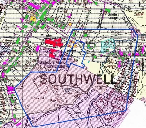
Southwell Conservation Area Appraisal

Southwell Conservation Area
Appraisal
CONTENTS

                                                                                            PAGE

 1.      INTRODUCTION                                                                       5

                            WHAT IS A CONSERVATION AREA? SOUTHWELL CONSERVATION AREA &      5
                            WHAT IS AN APPRAISAL

                            GEOGRAPHIC CONTEXT – LOCATION, POPULATION AND HERITAGE ASSETS   7

                            GEOGRAPHIC CONTEXT – LANDSCAPE SETTING                          8

 2.      HISTORICAL DEVELOPMENT                                                             10

                            SUMMARY OF SPECIAL INTEREST                                     17

 3.      CHARACTER AREAS                                                                    18

         MINSTER AND PREBENDAGE                                                             22

                            TABLE 1 PREBENDAL HOUSES AND PLOTS                              27

                            TABLE 2 & 3 BUILDING GAZETTEERS MINSTER AND PREBENDAGE          28

         TOWN CENTRE                                                                        31

                            TABLE 4 & 5 BUILDING GAZETTEERS TOWN CENTRE                     35

         THE BURGAGE                                                                        40

                            TABLE 6& 7 BUILDING GAZETTEERS THE BURGAGE                      44

         EASTHORPE                                                                          47

                            TABLE 8 & 9 BUILDING GAZETTEERS EASTHORPE                       50

         WESTGATE                                                                           54

                            TABLE 10 & 11 BUILDING GAZETTEERS WESTGATE                      57

         WESTHORPE                                                                          61

                            TABLE 12 & 13 BUILDING GAZETTEERS WESTHORPE                     66

 4.      CONCLUSIONS                                                                        69

 5.      BIBLIOGRAPHY                                                                       71

Page 2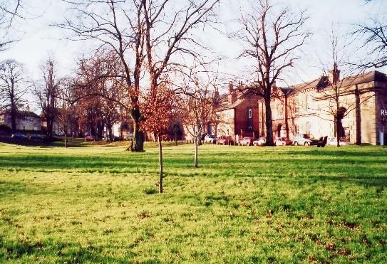
Southwell Conservation Area Appraisal
6.     MANAGEMENT PLAN                                                                   73

MAPS

       MAP1              CURRENT CONSERVATION AREA BOUNDARY

       MAP 2             CURRENT & PROPOSED CONSERVATION AREA BOUNDARY

       MAP 3             EXPANSION OF SOUTHWELL CONSERVATION AREA OVER TIME
                         (forthcoming)

       MAP 4             CHARACTER AREA OUTLINES (based on existing Conservation Area
                         boundary)

       MAP 5             SOUTHWELL TITHE MAP

       MAP 6             THE MINSTER – BUILDINGS

       MAP 7             THE MINSTER – TOPOGRAPHICAL FEATURES

       MAP 8             TOWN CENTRE – BUILDINGS

       MAP 9             TOWN CENTRE – TOPOGRAPHICAL FEATURES

       MAP 10            BURGAGE – BUILDINGS

       MAP 11            BURGAGE – TOPOGRAPHICAL FEATURES

       MAP 12            EASTHORPE – BUILDINGS

       MAP 13            EASTHORPE – TOPOGRAPHICAL FEATURES

       MAP 14            WESTGATE – BUILDINGS

       MAP 15            WESTGATE – TOPOGRAPHICAL FEATURES

       MAP 16            WESTHORPE – BUILDINGS

       MAP 17            WESTHORPE – TOPOGRAPHICAL FEATURES

                                                                                              Page 3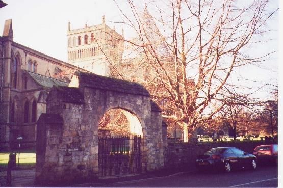
Southwell Conservation Area Appraisal

                                        INTRODUCTION | ONE

Page 4
Southwell Conservation Area Appraisal

Southwell Conservation Area
Appraisal
INTRODUCTION | ONE

T     his Appraisal document is an
      assessment        of       Southwell
      Conservation Area (CA). The aim of
the Appraisal is to define the special
interest of the CA that merits its
                                               SOUTHWELL CONSERVATION AREA
                                               Southwell was first designated as a
                                               conservation area in 1968 and extended
                                               in 1970, 1993 and at the last
                                               Conservation Area review in 2005. Map 1
designation and describe and evaluate
                                               shows the current boundary. Map 3
the contribution made by the different
                                               [forthcoming] shows how the Conservation
features of its character and appearance.
                                               Area boundary has changed over time.
                                               The boundary has been drawn to include
WHAT IS A CONSERVATION AREA?                   the Minster Church, the historic commercial
                                               centre of King Street and Queen Street,
The first CA was designated in 1967 under
                                               the Burgage and the former hamlets of
the Civic Amenities Act and there are now
                                               Easthorpe and Westhorpe.
over 10,000 in England. They are
designated for their special architectural     The most important features that
and historic interest.                         contributed to its designation as a
                                               Conservation Area were the presence of
In CAs there are some extra planning
                                               the Minster, its well-preserved historic
controls and considerations in place to
                                               layout, the high proportion of listed and
protect the historic and architectural
                                               unlisted buildings of quality, its strong
elements that make the place special.
                                               character and its attractive landscape
The current legal basis for designating CAs    setting.
is under section 69 of the Planning (Listed
                                               Southwell CA was first reviewed in full in
Buildings and Conservation Areas) Act
                                               2005 when a character Appraisal was
1990 (the ‘Act’). The provisions of the Act
                                               written for the first time, along with a
also require the local planning authority to
                                               number of boundary changes. The CA has
review existing CAs from time to time.
                                               then been reviewed again during 2021 in
                                               accordance with a District wide
                                               programme of CA reviews agreed via the

                                                                                         Page 5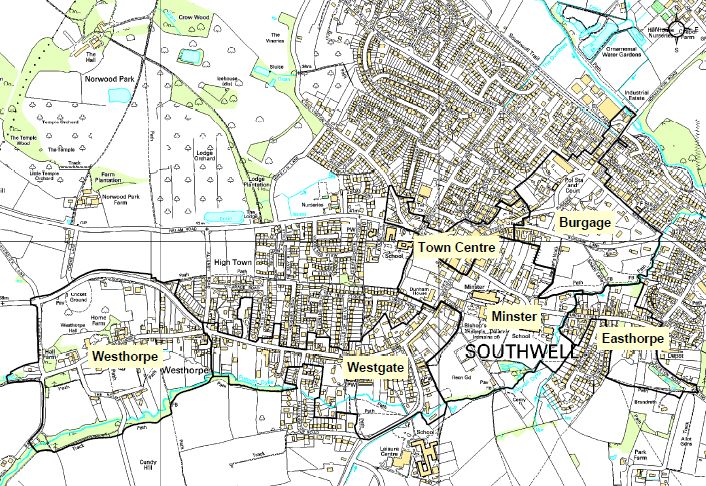
Southwell Conservation Area Appraisal
Council’s Economic Development
Committee in 2018.
These areas are outlined in the Boundary
Early consultation revealed several areas Review Document that accompanies this
where it could be considered that the draft Appraisal and which has been
boundary could change, primarily relating considered in an initial round of public
to Southwell’s landscape setting, engagement. 1
archaeological interest and C19/early
WHAT IS AN APPRAISAL?
C20 development. This relates to five main
areas: This document is an assessment of the
1. Land to north east of Greet Lily character and appearance of Southwell
Mill, along Station Road and CA. It broadly defines and records the
Normanton Road. To consider the special interest of the area. This will ensure
millrace, vehicular bridge and that there is an understanding of what is
fields between Southwell and worthy of conservation. The appraisal
Normanton. process helps inform policies for the
preservation and enhancement of the area
2. C19 workers’ housing development
along Dover Street and Chatham and will provide decision-makers with a
Street. characterisation of the historic
environment. This will enable a better
3. Land south of Westhorpe Dumble, understanding of the impact of future
area between Cundy Hill and development in the CA.
Halloughton Road.
CA Appraisals are based on guidelines set
4. Land south of the recreation park out in the Historic England publication
off Memorial drive, to include Conservation Area Designation, Appraisal
Potwell Dyke Grasslands, cemetery and Management (2019). The following
and fields south of Farthingate, up themes and sources have been explored in
to Crink Lane and Park Lane.
the preparation of this document:
5. Edwardian villas on Halam Road. Archaeological and historical
sites/monuments/buildings
In addition there are a number of smaller Social, economic and demographic
amendments proposed, primarily where background
the building has crossed through gardens
or buildings and requires a small Current and past land use
correction.
1 A consultation report summarising public engagement on
this process can viewed on the Council’s web site.
Page 6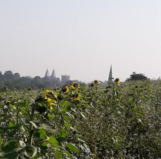
Southwell Conservation Area Appraisal
Geological and topographical assumed that the omission of any
mapping information is intended as an indication
Building types, groups of buildings, that a building or feature is not important.
density of buildings A detailed assessment of significance
Place names and historical specific to a building or site within the CA
references (e.g. road and transport should always be carried out prior to
evolution) proposing any change.
Aerial photos Furthermore, some buildings identified as
Important views, vistas and unlisted may in fact be regarded as
landscapes curtilage listed structures to the principal
Historic Environment Record (HER) listed building - the gazetteer tables and
data maps are not intended to be used to
Plot layout/building orientation and define the extent of a building’s Listing.
the importance of gaps between Further guidance and advice on CAs,
buildings and any wider open including how to get pre-application
spaces advice, can be found on the Council’s
The Southwell CA is a designated heritage website.
asset in its own right, and contains GEOGRAPHIC CONTEXT – LOCATION,
numerous individual heritage assets. These POPULATION AND HERITAGE ASSETS
include both listed and unlisted buildings.
The Area has been divided into character Southwell is a rural town, remote from any
areas and section 3 looks at these in turn large centres of population. It is 7 miles
to give an overall impression of the from Newark, 14 miles from Nottingham
character and appearance of the CA, and 22 miles from Lincoln. The town lies on
the A612, which passes through the CA
identifying some individual or groups of
area and links Nottingham with Newark.
heritage assets and why they are
important. One of Southwell’s main importance as a
town is derived from the presence of the
A full list of building heritage assets is Minster. It was largely by-passed by the
included in the building gazetteer tables industrial revolution, was never on any
within each character area. Whilst every established lines of communication and
effort has been made to create a never had a significant market. The centre
comprehensive list, it does not provide a of the town is mainly Georgian and
assessment of each individually and is remained relatively unchanged until recent
limited to what is readily visible from the expansion surrounded the historic core with
public realm. It should not, therefore, be C20 housing.
Page 7
Southwell Conservation Area Appraisal

The 2011 census records a population of       The central area of Nottinghamshire in
7297 living within the Parish and today       which Southwell is located is a plateau,
Southwell is predominantly a dormitory        fissured by streams. The fissures are known
town and a tourist destination.               as “dumbles” and it is generally on the
                                              south facing slopes of these that
The town is identified within the Council’s
                                              settlements are located. Southwell is
Local Development Framework Amended
                                              typical and it sits on the south-facing slope
Core Strategy (March 2019) as a ‘Service
                                              of Westhorpe Dumble/ Potwell Dyke.
Centre’ to a large rural area, having a
good range of local facilities, and is the    Development has extended in an east-
third largest settlement in the District.     west direction to include the once
                                              subsidiary settlements of Westhorpe and
The existing CA boundary covers an area
                                              Easthorpe so that the town now generally
of 1.0779km2.
                                              occupies the valleys of the dumble and the
There are 202 Grade II listed buildings,      River Greet and the wooded ridge of
four Grade II* and two Grade I listed         higher ground between them. To the north
buildings. The CA is also home to two         and south there are undeveloped slopes
Scheduled Ancient Monuments (SAMs),           and these form the rural, unspoilt
being the Archbishop’s Palace and the         backdrop to Southwell. The change
Roman Villa.                                  between town and country is well defined.
Southwell is part of the District wide Area   The town is approached on all sides from
of Special Advertisement Control (other       higher ground and from the ridges there
town centres are exempt but Southwell is      are panoramic views into Southwell and
not). Further information on this can be      across the town, with superb long distance
found in the Management Plan at Section       glimpses of the spire of Holy Trinity Church
6.                                            and the Minster, which is floodlit at night,
                                              as well as the Workhouse (which lies
GEOGRAPHIC CONTEXT – LANDSCAPE                outside the Conservation Area).
SETTING
The landscape setting of Southwell makes
a significant contribution to its character
and appearance. Southwell is set within
the heart of the Mid-Nottinghamshire
Farmlands. It is set within an undulating
landform that is well wooded and mature.
The town sits at the bottom of a shallow
basin, which gives Southwell an enclosed
and intimate atmosphere.

Page 8
Southwell Conservation Area Appraisal
as providing a number of significant vistas
from which to appreciate the town and its
landmark structure.
The landscape also contains elements of
archaeological interest with the physical
remains of the medieval open field system
surviving in places, along with other
earthworks of archaeological potential.
The proposed revised CA boundary shows
significant extensions to include much of
this important landscape setting.
Views towards Southwell Minster and Holy
Trinity Church across crops in the fields south Landscape Summary:
of the Westhorpe Dumble
New development should not break
the strong boundaries between the
These views are so important that the built up area and the surrounding
‘Southwell Landscape Setting’ document countryside.
was produced in 2012 by the District Vistas of the principal heritage
Council and County Council. This document assets of the Minster, Archbishop’s
looked specifically at the importance of Palace, Holy Trinity Church (as well
landscape setting to the town’s landmark as the Thurgarton Hundred
heritage assets. This informed a number Workhouse) should be protected.
of protected view cones across Southwell’s The natural corridors formed by the
principal heritage assets, which have been dumble, the river Greet and
identified in the Core Strategy (Amended numerous footpaths and rights of
Core Strategy March 2019) and which way should be protected.
have their own specific policies. The
policies seeks to protect views of and
across the principal heritage assets of the
Minster, Holy Trinity church, Archbishop’s
Palace and Thurgarton Hundred
Workhouse (the latter falling outside the
Conservation Area).
The landscape setting also contains an
extensive network of footpaths and
bridleways, which link the countryside with
the town and its conservation area, as well
Page 9Southwell Conservation Area Appraisal
HISTORICAL DEVELOPMENT | TWO
“…a country town with the overpowering presence of a
large medieval church’ N Pevsner, 2003
No one who sees Southwell Forgets it…Here is England
epitomised. Here is a cathedral in a country village”
Southwell Minster - a commentary for the visitor, High Heywood, 1960
Drawing of the North East view of Southwell
Minster,
Page1791,
10 by Samuel Hieronymous GrimmHISTORICAL DEVELOPMENT | TWO
U
ntil recently, the earliest certain
archaeological evidence of
settlement in the town was of a
large Roman villa, located to the east of
the present Minster, which appears to have
been occupied well into the 4th century AD Skeleton found in excavations in 2012 at the former
and is thought to be one of the largest such Minster School site, part of a Christian 7th to 9th
sites in the east Midlands. cemetery here
Numerous Roman finds have been At the former Minster School site evidence
recorded in this area and around of a possible ‘farmyard’ associated with
Southwell since the 18th century and the Roman villa was found, along with a
archaeological excavations from the stone structure which could have been the
1950s onwards have record the presence villa estate’s watermill. A Christian
of a large building dating to the 2nd cemetery overlay part of the villa site and
century AD with significant alterations and then later phases suggested ancillary
extensions in the 3rd and 4th centuries. In structures on the site associated with the
addition, over 30 early medieval Christian current Minster. As part of these
burials were recorded in the initial excavations the Scheduled Ancient
excavation and a further 225 during Monument entry of the villa was enhanced
subsequent work. Consequently the site is and the boundary extended in 2013. The
a scheduled monument (NHLE: 1003528). true extent of the archaeological resource
and potential here is still being
More recently the areas to the east and understood.
south of the scheduled monument have
undergone archaeological investigation, The evidence from Platts Orchard suggests
most notably at The Residence, on the the bodies here may have been part of a
former Minster School site on Church Lane small discrete Saxon cemetery, possibly
and to the north of Church Lane at Platts similar to that identified within the former
Orchard. Evaluation has also been Minster School site over 100m to the south
undertaken further to the south close to west on the opposite side of Church Street.
Potwell Dyke. All these sites have One of the burials from here has been
produced evidence for further intensive radiocarbon dated to between 665 AD to
activity dating from 1st century onwards, 866 AD.
including an 8th century inhumation This more recent archaeological
cemetery, industrial activity, a large block investigation, along with known find spots
wall, and other structures where a direct from Southwell, indicates that activity
relationship with the adjacent villa may be associated with the villa likely extends well
inferred. beyond the scheduled area, although the
precise location, nature and extent of this
is not yet fully understood. It is therefore
Page 11Southwell Conservation Area Appraisal
essential that specialist expertise and surfaces, domestic rubbish, potential
approaches to archaeological assessment building plots and the layout of regular
are in place from the earliest stage of strip plots were found, dating from the 11th
planning proposals so as to ensure the to 14th centuries. This suggests that the
significance of remains affected is Burgage Green area may have been an
sufficiently understood and their extension to the existing late Saxon town
importance is afforded proportionate or possibly a development relating to the
weight in the planning process. Burgage as a separate manor and is an
area of further archaeological potential.
As such, the Council is currently consulting
(within the Amended Allocations and The first pre-Roman archaeology at
Development Management Policies Southwell was also discovered during this
Development Plan Document (DPD): options fieldwork, being a number of flint tools,
report, July 2021) on a new proposed suggesting there was pre-historic
policy that would relate to mapped occupation at Southwell, probably more
evidence to show an area of high in the area down to the Greet rather than
archaeological potential, which would then under the current town.
require planning proposals to be
supported by site evaluation from the
earliest stages. A copy of the initial
proposed map is included in the
Management Plan, bearing in mind this will
be subject to further investigation and
refinement.
Historical sources place the Burgage as the
site of an Iron Age hillfort and early
evidence of earthworks were mapped, but
not in a way that accurately placed them Neck of a Medieval jug found in a test pit on the
Burgage (MBA Archaeology (2014) Burgage
on modern maps. The Burgage is also said Earthworks Project)
to have been the home of a medieval Hall
or Manor House as well as a medieval Earthworks (including those possibly
chapel. Given these sources and the described as Iron Age) and road layout
potential for archaeological interest the today indicate the possible square outline
Burgage was the focus of archaeological of an Anglo-Saxon Burgh of Southwell,
investigations between 2013 and 2014. including the Minster, prebendal plots on
Non-intrusive survey techniques and test the north side of Church Street, part of
pits were used and these have revealed King Street, Queen Street and West Gate.
evidence of previously unknown medieval
settlement in the Burgage Area, dating The known archaeology of Southwell has
between 11th and 14th centuries. The Iron expanded greatly in the last ten years by
Age hillfort, medieval manor and chapel a programme of pre-development
were not found, but evidence of yard investigations and proactive investigations
by the local archaeological community.
Page 12Southwell Conservation Area Appraisal
This has served to highlight the wealth and Southwell as ‘Sudwelle’ meaning ‘south
breadth of archaeological interest and spring’. The actual site of the south well has
potential across the town. The entry for the been identified at the junction of Fiskerton
Roman Villa SAM notes, ‘The whole town Road and Spring Hill. Southwell also
of Southwell appears to be rich in appears in the Domesday Book of 1086.
archaeological deposits including Roman,
Saxon and Medieval deposits’. The body It is likely that the Minster is on the site of
of archaeological information is constantly this early church but the existing building is
being added to and the Nottinghamshire thought to have been started between
Historic Environment Record (HER) can be 1109-14, replacing an earlier stone
searched for up to date information. church. At this time the status of the Minster
Longer-term aspirations may be to was raised to Mother Church of all
produce a wider map to show areas of Nottinghamshire. On the formation of the
known archaeological significance and Southwell Diocese in 1884, the Minster
areas of archaeological potential. became a Cathedral.
Archaeology Summary The Minster provided a strong educational
history to the town with the current Minster
Southwell has a special archaeological School being one of the oldest continuous
record with areas of proven educational foundations in England, tracing
archaeological significance that are its origins to the establishment of Southwell
either Scheduled or should be treated Minster and the education of the choristers.
of schedulable quality.
There is also significant archaeological The Church had a unique system of
potential in the town. Pre- administration in the form of a collegiate
determination evaluation as well as body of secular canons that administered
archaeological planning conditions the affairs of the Minster Chapter. The
may be required for new canons were supported by income from
development. endowments of property and tithes known
Our body of archaeological as prebends. As a result the canons were
knowledge for the town is always known as prebendaries. Each prebendary
expanding and Southwell is a positive had a house in Southwell named after the
example of community archaeology in village from which their revenues were
action. The Nottinghamshire HER derived (except Halloughton Prebendary
should be consulted for up to date which had its prebendal house at Manor
information. Farm in Halloughton). These houses were
The first documentary evidence of set in large plots in Church Street and
Southwell is a charter of 956, albeit in the Westgate and many of their large
form of a C14 copy, in which King Eadwig gardens are still evident. The collegiate
granted Southwell to Archbishop Osketyl, body lasted until 1840 when an Act
who is believed to have established or suspended future appointments to
reformed the church. This charter refers to prebends and was extinguished
altogether with the death of the last
Page 13Southwell Conservation Area Appraisal
prebendary in 1873. This collegiate
foundation was larger and lasted longer
than any other in the country and the
prebendal mansions comprise a distinctive
group of houses that dominate the historic
core of Southwell, combing architecture
grandeur with earlier, sometimes more
hidden, vernacular features.
To the south of the Minster stands the
substantial ruin of a medieval palace of
the archbishops of York, rebuilt in the late Undated photograph of haymaking on the
C14 and C15 but possibly on the site of Burgage Green
an C11 archbishop’s residence. The palace
was severely damaged in the Civil War,
when Cromwell’s troops were said to be To the east and west of the town were the
have been stabled in the Minster itself. The medieval settlements of Easthorpe and
medieval archbishops of York had three, Westhorpe. The names of Easthorpe and
possibly four, deer parks in the Southwell Westhorpe date from the occupation by
area, one was in Southwell itself, adjacent the Danes in the C9 and C10, “torp” being
to the Palace. the Scandinavian for an outlying hamlet
near a large settlement. They were
The core of the town grew up around the
agricultural in character. Each village may
central cross roads and was dominated by
have had its own chapel. Trade directories
the Minster and its prebendal houses. To
suggest that while Easthorpe developed a
the north east is an open area of land
more general mix of trades, in keeping
known as the Burgage – this was a
with Southwell itself, Westhorpe
separate manor belonging to the
appeared poorer, with rather more
Archbishops of York, whilst the rest of the
framework knitters, agricultural labourers
town was held by the Chapter. The Manor
and paupers. Easthorpe being closer
covered a larger area than survives as
merged with the town of Southwell first.
Burgage Green today. It seems likely that
Westhorpe only merged when the
part of the open land we see today was
straggle of C18 and C19 development
once built on but the Green was most
along Westgate was consolidated in the
recently used for grazing and hay making,
C20.
along with fairs and markets. Informal
pony races were also held on the Burgage Records from the C16-C18 show the
and in 1898 the race meeting moved to continued development of Southwell
the modern racetrack site near Rolleston. around the Burgage, King Street, Queen
Today Burgage Green is an important Street, Westgate and Church Street. The
area of open space and still used for Southwell tithe map of 1841 (see Map 5)
public events. shows this historic layout and it is this core
Page 14Southwell Conservation Area Appraisal
that formed the basis of the existing CA station building was rebuilt in 1871 when
boundary. the line was extended. The line closed in
1965 and a section of the former line was
The town proved popular with C18 and designated a public footpath in 1970.
C19 gentry and professional men and this
has resulted in an impressive legacy of The levels of post C18 development were
large and high status Georgian houses. low in Southwell and this helps to account
Additionally, there was a phase of for the relatively small size of the town. It
rebuilding and re-facing existing buildings was the presence of this collegiate
in the C18 and C19, so many Georgian foundation that gave the town its regional
looking buildings now disguise a much importance, as it lay a few miles off the
earlier core. Recent tree-ring dating main lines of communication in an area that
projects have been useful in highlighting was agriculturally fertile but which lacked
this trend and in identifying earlier fabric. mineral resources. As a result it
experienced relatively little industrial
While not predominantly an industrial development, remaining unchanged until
town Southwell does have an industrial recent expansions surrounded the historic
heritage. Southwell was an important area core in the C20. Nevertheless, that core is
for hop growing in the 1700s and 1800s essentially unspoilt, with a fine legacy of
– mainly along the banks of the River Georgian houses; indeed, ‘Southwell is
Greet. There were many malthouses in considered by many to be not only an
Southwell and the Maltings and outstanding historic town but also possibly
Brewmaster’s House on Newark Road, the county’s finest small town’ (Stroud,
erected 1825, are testimony to this (2001) Extensive Urban Survey, 2001.
industry, although at one time most of
Southwell’s inns had their own brewing The town has associations with several
facilities. Greet Lily Flour Mill, built 1851 notable historical figures. The former
but remodelled following two disastrous Palace of the Archbishop of York stands
fires, still survives, while close to Southwell next to the Minster and its most infamous
is Maythorne, an industrial hamlet built by occupant was Cardinal Wolsey. It was in
the River Greet. The complex comprises a the State Chamber of the Great Hall that
series of mills and cottages, probably first he would have held his last frantic
used for cotton spinning but certainly later meetings in 1530 to extricate himself from
for silk. Lace also featured in Southwell failing to secure Henry’s VIII first divorce.
and once the House of Correction ceased King Charles I in 1646 is said to have spent
to be used in 1880 the building was used his last night of freedom at the Saracen’s
as a lace factory. The making of lace was Head before surrendering to the Scots in
also carried out on a domestic scale in the Civil War. The Reverend Becher
framework knitters’ workshops, as seen in (1770-1848) was the Vicar General of
many other Nottinghamshire towns and Southwell Minster and was a prominent
villages. Poor Law reformer. Additionally, the
regime implemented by local Poor Law
A railway line from Rolleston to Southwell reformer George Nicholls at the Southwell
was completed in 1847 and the current
Page 15Southwell Conservation Area Appraisal workhouse proved so successful, in terms of money saving, that the Poor Law Reform Act of 1834 was based largely on the Southwell practice. The poet Lord Byron also stayed at Southwell during his Cambridge visits, residing in his mother’s residence Burgage Manor, and publishing his first collection of poems during his time in Southwell. The town is additionally credited as being the home of the Bramley apple, planted from pips by Mary Ann Brailsford in 1809. They were planted in the girl’s garden on Easthorpe, where the tree still survives. There are still many unanswered questions and gaps in our knowledge about the development of Southwell but the breadth and variety of archaeological and historic interest is impressive and significant. Page 16
Southwell Conservation Area Appraisal
SOUTHWELL CONSERVATION AREA – A SUMMARY OF SPECIAL INTEREST
Southwell is famous for its Minster church, which is the cathedral church of
Nottinghamshire. Although it has a very large church, it is a small town and
Southwell has the distinction of being the smallest cathedral town in England. The
Minster acts as a waymarker for the town and gives a unique ‘village cathedral’
character to the town as well as a strong sense of identity.
The Minster is complemented by a high quality and remarkably unspoilt townscape,
which includes a special collection of ‘prebendal’ houses in large plots and the
medieval ruins of the Archbishop’s Palace, creating a collection of historic buildings,
unique to Southwell. This is complemented by a high number of high status Georgian
houses and some fascinating vernacular buildings, including an impressive timber
framed heritage dating back to the early C14.
The town previously received formal recognition by the Council for British
Archaeology as being a town of ‘outstanding historic quality’. Today Southwell is
considered by many to be not only an outstanding historic town but also possibly
the county’s finest small town.
The landscape setting of the town contributes strongly to significance providing an
attractive rural backdrop to an impressive and often dramatic built townscape.
Landscape also spreads into the heart of the Conservation Area in well-used and
significant pockets of open land. The attractive composition of landscape and views
towards key historic buildings is a defining feature of Southwell Conservation Area.
More recent archaeological investigations in the Town have added to our
knowledge, showing considerable archaeological interest and archaeological
potential that merit Policy led protection.
Southwell’s heritage is specifically identified as being key to the District’s tourism
offer (Amended Core Strategy, March 2019) and the Conservation Area has
strong associations with key historical figures and events, adding to the unique
identity of Southwell.
Page 17Southwell Conservation Area Appraisal
CHARACTER AREAS | THREE
Page 21Southwell Conservation Area Appraisal
CHARACTER AREAS |THREE
S outhwell CA can be split into six
character areas and it is a feature of
these character areas that they are
very distinct, with little blurring of their
boundaries. These areas are The Minster
The exclusion of any such item from this
list does not necessarily indicate that it
has no contribution to make to the
character of Southwell Conservation
Area and all applications will be treated
and Prebendage, Town Centre, The on their own merits.
Burgage, Easthorpe, Westgate, and
Westhorpe. The assessment deals with
each of these in turn.
Each character area has its own building
gazetteers and maps identifying
important buildings and topographical
features. These have been identified
because they contribute most strongly to
the character and appearance of the
conservation area.
CHARACTER AREAS. There are six discernible character areas within Southwell CA,
reflecting their predominant historic character (map to be updated for final
document, dependent on final adopted boundary)
Page 21Southwell Conservation Area Appraisal
1. MINSTER AND PREBENDAGE giving Southwell its distinctive way-finder
CHARACTER AREA and identifier.
The Minster and Prebendage Character The Minster is surrounded by a walled
churchyard, which provides an open space
Area primarily covers Church Street,
at the centre of the town. The buildings on
Westgate and Bishops Drive and is shown the north west corner including the Crown
on maps 6 and 7. A significant potential Inn are assumed to be encroachments into
extension is proposed to cover the this open space.
landscape setting to the south of the town.
The Archbishop of York established a
There are, broadly speaking, three main residence at Southwell to the immediate
elements within the Minster area; south of the Minster. No evidence of this
early building remain, however, there are
The Minster, its churchyard and ruins of a rebuilt palace dating from the
associated buildings late C14 and C15 which was largely
The Prebendal plots destroyed in the Civil War. The present
The Medieval Park and landscape to the Bishop's Manor, home of the Bishop of
south. Southwell, was built in 1907 within the ruins
of the Archbishop’s Palace. The remains of
Southwell Minster, the Churchyard the Palace are now a Scheduled Ancient
and Associated Buildings Monument. This is one of two Scheduled
Ancient Monuments within the Minster area.
The other is the Roman Villa site, located to
The Minster has always had a dominating the east of the Minster.
influence throughout the history of the
town. It is a fine and intact example of a The Prebendal Plots
Norman and Early English grand church
and is famous for its distinctive ‘pepper There are quite a significant number of
pot’ spires and delicate carved leaf large houses in the Minster character area,
decoration in the Chapter House, amongst most of which are prebendal houses, or
other delights. The development of the their replacements, set within their own
Minster eventually led to it acquiring grounds. These were the residences of the
cathedral status in 1884 when the prebendaries (secular canons) who were
Southwell Diocese was formed. A great supported by income from endowments of
deal of the very special character of properties and tithes known as prebends.
Southwell stems from the fact that it has a By the end of the C13, sixteen prebends
very large church for a very small town, and prebendal houses had been
giving it a unique ‘cathedral village’ established. There are now only nine
character, an imposing and impressive remaining and none is the original
physical presence throughout the town and building, although parts of the originals
Page 22Southwell Conservation Area Appraisal
have been incorporated into the fabric of was in existence in the 1330’s. The deer
some of the later buildings. park stretched southwards from the
Archbishops Palace to Crink Lane and out to
The most remarkable feature of the layout Park Lane. It has been suggested that Park
was that the prebendal houses stood Farm on Crink Lane could have been the
detached within their own large grounds parker’s house. The area that was covered
rather than in a precinct or defensive by the former deer park includes the former
walled enclosure. The prebendal plots Minster School site off Church Street which
have similarities with burgage plots found is now open parkland, the current Minster
in the layout of medieval towns but whilst School on Nottingham Road and also some
the shape and proportions are similar, the of the modern development on Farthingate.
prebendal plots are considerably larger. The area is now predominately open space
The plots on Church Street would have and used for recreation. The proposed
originally extended to Burgage Lane. revised Conservation Area boundary would
Those on Westgate extended to a line encompass more of this former deer park.
marked today by a public footpath. On a
similar note it is likely that the churchyard
originally occupied the whole block defined Summary of Interest Minster and
by Church Street and Westgate. Prebendage
The established layout of this area of
large houses set within their own
extensive grounds should be retained.
It is important that the surviving
prebendal plots are not sub-divided and
not developed. These are important to the
historic and unique layout of the town and
provide the setting to some of the town’s
most important and distinctive listed
buildings.
The openness of the area that was once
Prebendal Houses and plots (traced from
the former Medieval Deer Park should be
Norman Summers – A Prospect of Southwell) retained and given special consideration
in the development process.
Buildings
The Medieval Deer Park and Landscape to
the South The number of listed buildings and positive
unlisted buildings in this character area is
The Minster has a backdrop of open space high. Buildings tend to be large, well
to the south, which is formed from the proportioned and individually designed.
remnants of a former deer park. This was Most have brick boundary walls.
once known as Little Park or New Park and
Page 23Southwell Conservation Area Appraisal
Of the sixteen original prebendal houses, continued in use as a lodging house for the
nine survive in the form of a house and plot. clergy and for a short time, afforded
Table 1 below highlights their new name, accommodation for the Collegiate
if they survive, and those that no longer Grammar School. The chantry priests’ house
exist. was demolished in 1819 to provide a site
for a new Grammar School building (now
The prebendal house of Oxton II (the Red used as the Minster Centre). The buildings
Prebend) was demolished as recently as the to the west of the former Grammar School,
early 1970s to make way for extensions to including the Crown Inn on the corner, are
the Saracen’s Head Hotel. The present assumed to be encroachments into the
prebendal buildings are mostly northwest corner of the churchyard.
replacements on the same sites, dating from
the late C18. Most of the original houses Summary
would have been timber framed and
fragments of the earlier buildings survive in Retain the high quality of buildings
some of these later buildings. There are and materials in this area.
some re-used roof timbers at Dunham House Retain the distinct character of this
and some evidence of an earlier stone area compared to the more high
building at Norwell Overhall (9-11 Church density commercial core
Street). Unfortunately the roof at South
Muskham Prebend was destroyed by fire in
September 2001 and was the best Spaces, Landscape, Boundaries and
example a crown post roof in Floorscape
Nottinghamshire. The roof structure has now
been restored. There are a number of important open
spaces within the Minster area. These
The contrast between the cramped and
include the Minster Churchyard, the Palace
congested nature of the commercial area
Gardens, the prebendal plots and
along King and Queen Streets and the
gardens of the large houses in this area,
spacious layout of the former prebendal
as well as the Memorial Recreation
mansions in their large gardens spread
Ground and adjoining open areas.
along Church Street and Westgate is a
fundamental component of the town’s The gardens at the Archbishops Palace are
special character. now landscaped and open to the public,
making a valued additional recreation
A chantry priests’ house in the form of a
area and a dramatic backdrop for
quadrangle with a courtyard garden was
built in the churchyard, to the northwest of outdoor performances. It also allows for
the Minster, for the chantry priests to live “in closer appreciation of the ancient ruins
common”. Its date of construction is and strengthens the visual and historical
uncertain but it is known that the first chantry links between the palace and Minster,
was endowed in 1241. Chantries were giving a better understanding of the
abolished in 1547 and the building special history of Southwell.
Page 24Southwell Conservation Area Appraisal
The demolition of the former Minster School heritage assets. The area also includes
buildings on Church Street was followed by earthworks suggesting archaeological
approval to build 13 new houses. The interest and potential.
archaeological investigations carried out in
advance of this work have greatly widened The Minster is a prominent landmark within
our knowledge of the archaeological the town and can be seen for miles around.
record of Southwell. In the end the The recreation ground and land to the
residential development did not transpire south has good views of both the Minster
and instead the site was bought and gifted and of the spire of Holy Trinity Church.
to the Chapter of Southwell Minster for the
benefit of the town. This forms the Higgons There are many groups of important trees
Mead open space and is a significant within this area. Those of particular note
improvement to the Conservation Area in include an avenue of trees along the
the last twenty years. The loss of a building footpath to the south west of the war
of incongruous and ubiquitous design and its memorial at the end of Bishops Drive and
replacement instead with open land for use
the area around Squire’s Pond.
of the town better reveals the open layout
of the former deer park, as well as Brick boundary walls are particularly
preserving an area of known important within this area and many of
archaeological interest and potential. them are listed. They make a significant
contribution to the quality of the public
The Memorial Recreation Ground is not realm.
only a valued public resource but
In terms of floorscape the predominant
preserves a vestige of the once larger
areas of quality traditional Yorkstone exist
deer park. While the character today is of
in and around the Minster Churchyard,
suburban park in places, the extent of
alongside the Trebeck Memorial Hall and
greenery and landscaping preserves a
certain paths around the Prebendal
strong character of this historically
houses. There are also examples of
significant area. The park also leads out
granite setts and gravel.
directly into the surrounding countryside
around the Town, keeping Southwell well Summary
connected with its special landscape
setting. It is important to conserve the open
nature of the key open spaces and retain
This wider landscape to the south of the the visual links between the Minster, the
town is important for its landscape setting, former Archbishop’s Palace and wider
including the former deer park and the former deer park.
network of paths, tracks and lanes. This is Subdivision of the prebendal plots would
a well-used resource and provides some be harmful and erode their special
character as high status houses, set in
excellent views across to the key landmark
large grounds, forming part of a special
Page 25Southwell Conservation Area Appraisal group with strong links to the Town’s Any future surfacing schemes in the history. public realm should be made up of high Strive to retain important views, trees, quality traditional materials, such as walls and gates within the conservation Yorkstone and granite setts. area. Pay special attention to the setting of the Memorial Park in the properties adjacent, taking care not to urbanise or suburbanise the boundaries. Page 26
Southwell Conservation Area Appraisal

TABLE 1 PREBENDAL HOUSES AND PLOTS
No. Old Name                                       Present Name
1    Oxton II                                      No longer existing
2    Altera Prebenda de Oxton (Oxton I)            Cranfield House, Church Street
3    Sacrist or Sextons Prebend                    Sacrista Prebend, 4 Westgate
4    Woodborough                                   Woodborough, 31 Church Street
5    Norwell Overhall                              9-11 Church Street
6    Palace Hall in Norwell or Norwell Palishall   13 Church Street and adjacent car park
7    3rd Prebend in Norwell                        No longer existing
8    Dunham                                        Dunham House, 8 Westgate
9    North Muskham                                 North Muskham Prebend, 23 Church Street
10   South Muskham                                 South Muskham Prebend, Church Street
11   Halton als Halloughton                        No longer existing (was in village of Halloughton)
12   Beckingham                                    No longer existing
13   Normanton Prebend                             Normanton Prebend
14   Eaton                                         No longer existing
15   Rampton, 6 Westgate                           Rampton, 6 Westgate
16   North Leverton                                No longer existing

                                                                                                    Page 27
Southwell Conservation Area Appraisal
TABLE 2 THE MINSTER AREA - LISTED BUILDINGS
Street Building Grade
Church Street Gateways and boundary wall at Minster Church Yard adjacent to II
Church Street
9 Church Street (former Natwest Bank) II
Minster Lodge, 11 Church Street II
13 Church Street and adjacent garden walls II
Willoughby House, 21 Church Street II
North Muskham Prebend, 23 Church Street and attached boundary II
wall and Kirkland House
Cranfield House and garden walls (No. 25 Church Street) II*
Ashleigh, 31 Church Street and attached garden walls II
41 Church Street and garden boundary wall II
The Minster I
Normanton Prebend and attached garden walls II
The Old Grammar School (now Minster Centre) II
South Muskham Prebend II
Cottage adjoining stable and carriage house 25 metres east of II
South Muskham Prebend
The Old Rectory II
The Residence, Vicars Court and adjoining boundary walls II*
Potwell Dyke Bridge II
Westgate 1 Westgate II
2 Westgate II
4 Westgate II
Boundary Wall at Sacrista Prebend, 4 Westgate II
Gateway and flanking walls at Minster Churchyard II*
5-7 Westgate II
Page 28Southwell Conservation Area Appraisal
Westgate cont. Rampton Prebend, 6 Westgate II
Boundary Wall at Rampton Prebend, 6 Westgate II
Westlodge, 9 Westgate and boundary wall and gate piers II
Dunham House, 8 Westgate II
Boundary Wall to Dunham House, 8 Westgate II
Summerhouse to rear of Dunham House II
1 Westgate II
2 Westgate II
4 Westgate II
Boundary Wall at Sacrista Prebend, 4 Westgate II
Gateway and flanking walls at Minster Churchyard II*
5-7 Westgate II
Bishops Drive The Bishops Manor and remains of the Bishops Palace, Bishops Drive. I
Page 29Southwell Conservation Area Appraisal
TABLE 3 THE MINSTER AREA – POSITIVE UNLISTED BUILDINGS IN THE CHARACTER
AREA
Street Building
Church Street The Coach House to the rear of 23
27
33
33A
Minster Shop and Refectory
Crink Lane Park Farm (subject to proposed expansion of the Conservation Area)
Westgate 3
Buildings to rear of Rampton Prebend
Building to rear of Sacrista Prebend
K6 telephone box in front of Dunham Prebend
Bishops Drive The War Memorial Gates
Building in north west corner of recreation ground
Trebeck Memorial Hall
Page 30TOWN CENTRE Southwell never historically developed a
thriving market and the area that is
The Town Centre character area covers
assumed to have been the market place on
Church Street, Halam Road, King Street,
the south side of King Street was built
Kirklington Road, Market Place, The
upon, possibly in the Middle Ages. The
Ropewalk, Queen Street and Sheppards
road called Market Place surrounding the
Row.
crossroads is not thought to be the original
Layout site, although a small market was here in
the late C18th and early C19th. The current
This area forms the commercial centre of market is held on a gap site in the King
the town and is characterised by a tightly Street frontage.
knit urban form. Buildings are densely
packed on narrow plots because the Queen Street leads from the town centre
extensive use of land for church properties and is transitional in character.
left little space for secular town centre Commercial property stops quite abruptly
buildings. These narrow plots are evident at the end of Bull Yard, which is dense in
layout, thereafter the road is residential
today, particularly on the north side of
with buildings widely dispersed. In this
King Street where Bull Yard, Waterloo area large houses with large gardens, such
Yard and Portland Arcade are typical. as at 32 Queen Street, The Hollies and St
They are characterised by the principal Mary’s House, are prominent. The large
building facing the street, with smaller gardens with trees, the houses and the
buildings built behind at right angles. The boundary walls are all important to the
principal building has an archway to allow conservation area character.
access to the ones at the rear. The yards
are not evident on the south side of King The proposed Conservation Area would
Street as the space here was even more be extended to capture three significant
Edwardian villas on Halam Road.
constrained by the Prebendal plots
opposite the Minster Church. Summary
The town suffered transport problems, In any future development proposals
which are typical of a compact and busy a high density form of development
commercial historic core. Its central streets is appropriate for the commercial
were narrow and frequently congested centre.
with a series of pinch points that caused The distinct change in character
conflict between vehicles and pedestrians. along Queen Street should be
The one way system and paving scheme maintained.
now in place along King Street and Queen Buildings
Street strikes a balance between the
needs of all road users and has made a The great majority of the existing buildings
more attractive and less traffic dominated date from 1750-1850 and tend to be
environment here. more vernacular in character than
Page 31Southwell Conservation Area Appraisal
architecturally outstanding. Most are listed contribution to the post-Victorian housing
or are considered to make a positive stock of the town.
contribution to the conservation area.
The buildings exhibit a variety of heights,
Of particular importance is the Saracen’s rooflines and fenestration and a mix of
Head which is a rare, high quality, timber stucco and red brick, slate and pantile and
framed building dating from circa 1460. styles range from Georgian to Victorian to
The building has interesting wall paintings Edwardian.
dating from the late C16 or early C17,
The rear elevations of buildings in this
which were not discovered until the 1980s
area are sometimes prominent and
and 1990s, hidden under later plaster.
important. Views from the yards, rear car
The building is one of only three significant
parks and across the Minster grounds pick
examples with domestic wall paintings in
up these areas. Chimneys, roof profiles,
the whole of Nottinghamshire (the other
rear staircases, ventilation units, extensions
examples being in Newark) and such work
must all be considered for their impact on
is rare in the East Midlands region
these views.
generally. The building was originally
jettied at first floor but was under-built in Shop fronts make a major contribution to
brick in the C18, along with distinctive sash the character of the town centre and their
windows. This phase is highly attraction lies in their traditional
representative of the ‘Georgianisation’ of appearance. It is important to reinforce
the town at this time. The Town’s Assembly this character by attention to detailed
Rooms, built shortly after 1805, are now design and materials.
part of the public house. This is a landmark
building terminating the view from Church In this respect the composition of current
Street. Riverside Church Centre may seem unusual
here, as this is actually a former grocer’s
Also of interest in this character area is the store inserted in the 1920s to the garden
former theatre on Queen Street (now deli) of Burgage House. While the shop window
which was converted from an earlier has changed the surrounding fluted
building into a theatre in 1816. Also of pilasters date to this period.
note is the Methodist Chapel of 1839, built
in part over a right of way, the presence The most important elements for shopfronts
of which can be seen in unusual the and advertisements are;
colonnaded section of the ground floor. The framing of the shop front with
The large and decorative Edwardian columns, piers or pilasters
villas, set in large grounds, on Halam Road A vertical emphasis to the windows
represent the Edwardian expansion of the Traditional materials, usually painted
town in this area and make a positive timber
Page 32Southwell Conservation Area Appraisal
Colour that should harmonise with the maintains the current links the market place
street has to rest of the town.
Signs that are painted in a traditional
The open space created at the junction of
style
Market Place and Queen Street was
Sensitively designed and located
internal security shutters, only if created in 1920 by the demolition of
necessary number 8 Market Place. This has now left,
One hanging sign, of traditional once internal, timber framing exposed to
appearance if necessary (illuminated the gable end (probably dating from the
if needed). late C15 to early C16), making an
interesting and attractive backdrop for
Advertisement Consent is often needed to this space, which is now used for outdoor
replace signage. Please contact the dining along with public seating. While the
Council if you considering any works to loss of the corner building so long ago is
shopfronts and advertisements. regrettable this now makes for a well-used
Summary and vibrant space within the core of the
town.
The visual impact and importance of
views of the rear elevations should The yards next to and behind the street
always be considered in any frontages are tightly knit and are
development proposals. attractive spaces. They have an intimate
Reference should be made to the character with shops and houses on either
Newark and Sherwood District Council side. Bull Yard has become another small
Shopfront Design Guide for detailed but valuable open space, used as a cut
guidance on all aspects of shopfront through but also again for outdoor dining.
design and signage.
There are fine examples of traditional
Spaces, landscape and boundary materials beneath the arch on Waterloo
features Yard and in Bull Yard. If further yards are
The major open space in this tightly built developed the use of traditional materials
urban form is the King Street Market would positively enhance the areas.
Place, which is a gap site in the street
frontage. Environmental improvements Many spaces are also enclosed by historic
have given the site definition and walls, as in Queen Street, and it is
character and it makes a positive important that these remain and are
contribution to the street. While a sense of properly maintained.
enclosure to the rear of the site is There are several footpaths amongst the
somewhat lacking the current arrangement buildings that provide good pedestrian
balances the different uses here and routes. They are a valuable resource and
lead the pedestrian through the heart of
Page 33Southwell Conservation Area Appraisal
the historic core. The enclosure to some of town with outdoor dining areas. The use
these would merit improvement. and appearance of these spaces needs
careful consideration in any future
Trees and soft landscape are not
particular features of this area, which is developments.
generally built up. However specimen
trees in the King Street Market Place and
at the junction of King Street with Queen
Street do act as focal points. Also of
importance are the trees and gardens in
the larger houses along the top of Queen
Street and Halam Road, which soften and
contrast with the buildings and make a
positive contribution to the conservation
area. Outside the character area, trees in
Dunham, Rampton and Sacrista Prebends
form a strong backdrop to the town centre.
Street furniture and road and pavement
surfaces have improved considerably
through a sensitive public realm scheme
and traffic management. This then
complements the many pockets of historic
paving and contributes to the attractive
townscape qualities of this commercial
core of the town.
Summary
The investment in the public realm and
paving works should be protected with
sensitive repairs when required.
The rear yards are generally attractive
spaces and form some important routes
through the town. These connections, as
well as their special built form and
paving, should be conserved.
The areas of public open space in this
character are small but valuable and
enhance the commercial offering of the
Page 34You can also read