Strategic Plan International GNSS Service 2017
←
→
Page content transcription
If your browser does not render page correctly, please read the page content below

International GNSS Service

                      Strategic Plan
                                           2017

2017 Strategic Plan                            1
IGS community members at the 2017 IGS Workshop in Paris, France
Photo: IGN/ Xavier della Chiesa

                                                                Editor
                                                    IGS Central Bureau                                                                                  4 Executive Summary

                                               Contact Information                                                                                      5 Introduction & Mission
                                                 IGS Central Bureau
                                          Jet Propulsion Laboratory                                                                                     8 Organizational Values
                                   California Institute of Technology
                                                        M/S 238-540                                                                                    10 IGS Data & Products
                                               4800 Oak Grove Road
                                         Pasadena, California 91101                                                                                    14 IGS Strategy for 2017 & Beyond
                                           United States of America
                                                                                                                                                       15 Goals & Objectives
                                            www.igs.org | cb@igs.org
                                                                                                                                                       23 Looking Forward

                                                                                                                                 Table of
                                                                           The International GNSS Service (IGS)
                                                                                                                                                          Appendices
                                                                           ensures open access, high-quality GNSS data
                                                                           products that enable access to the definitive                               27 Appendix A: Formulation, Implementation
                                                                           global reference frame for scientific, educational,
                                                                           and commercial applications.                          Contents                 & Monitoring of the Strategic Plan

                                                                                                                                                       29 Appendix B: History of the
                                          The IGS is a service of                                                                                         International GNSS Service
                             Global Geodetic Observing System
                           International Association of Geodesy                                                                                        31 Appendix C: Components & Roles
                International Union of Geodesy and Geophysics
                                                                                                                                                       37 Appendix D: IGS Governing Board &
                                    IGS is a Network Member of                                                                                            Membership as of 2017
          International Council for Science - World Data System
                                                                                                                                                       39 Appendix E: IGS Organization Structure &
                                                         Copyright 2018                                                                                   Inter-Organizational Relations
                                                     All rights reserved
                                                                                                                                                       40 Appendix F: Product Availability Standards &
                                                                                                                                                          Quality of Service

                                                                                                                                                       41 Appendix G: Glossary of Acronyms

      1                                                                                        International GNSS Service        2017 Strategic Plan                                                     2
Executive Summary

                                 Dear IGS community and stakeholders,

                                 Welcome to the latest revision of the IGS Strate-     The development of this plan has been guided by
                                 gic Plan. Since the 2013 revision of the strategic    extensive community consultation. Accordingly,
                                 plan, the IGS has continued to grow and evolve,       our goals and objectives as documented in this
                                 all while maintaining its core values and mission.    plan which collectively aim to continue the ad-
                                                                                       vancement of the IGS in the coming years have
                                 The IGS continues to coordinate a collabora-          been refined to reflect the changing landscape.
                                 tive research infrastructure at the global scale,     The Plan is intended to guide our service to the
                                 not only through the GNSS observing network           community, and is not intended to be restrictive,
                                 and data centers, but also through the exten-         therefore allowing the flexibility to ensure the
                                 sive analysis capability contributed by the partic-   best possible service to the geodetic commu-
                                 ipants. The IGS encourages peer reviewed and          nity.
                                 benchmarked science, not only in the application
                                 of IGS data, products and services, but also in       This plan was developed by the IGS Central
                                 the very generation of these outputs. It is in this   Bureau and Governing Board. It does however
                                 way that the IGS products continue to be en-          represent the large cumulative body of work un-
                                 hanced through time.                                  dertaken by the many IGS participants and con-
                                                                                       tributors.
                                 The breadth and number of contributors to the
                                 IGS, and their high levels of commitment, have

                                                                                       Gary J
                                 however resulted in high levels of performance
                                 and reliability of product generation and delivery.
                                 It is the combination of this sustained service,
                                 high quality data and products, and open data
                                 policies that has resulted in the IGS being recog- Gary Johnston
                                 nized as the premier source of the highest-qual- Chairman of the IGS Governing Board
                                 ity multi-GNSS related standards and conven- Geoscience Australia
                                 tions, data and products globally.

3   International GNSS Service   2017 Strategic Plan                                                                                  4
Introduction & Mission

Since its formation as a service of the
International Association of Geodesy (IAG) in
1994, the International GNSS Service (IGS) has
produced very high quality Global Navigation
Satellite System (GNSS) data and products
that enable the highest accuracy use of GNSS
technologies for scientific and other applications.
The IGS data and products are essential for Earth
science research; multi-disciplinary positioning,
navigation, and timing (PNT) applications; and
education.

Mission
The International GNSS Service provides, on an
openly available basis, the highest-quality GNSS
data, products and services in support of the
terrestrial reference frame, Earth observation
and research; positioning, navigation and timing;
and other applications that benefit science,
education, and society

5                                                     International GNSS Service   2017 Strategic Plan   6

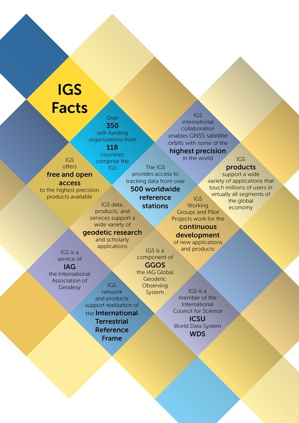
Organizational Values

                                                            The IGS is organized as a world-wide federation
                                                            of over 350 participating organizations across 118
                                                            countries who voluntarily pool their resources
                                                            and capabilities to from a cooperative GNSS
                                                            infrastructure.

                                                            Participation within IGS is open to any public or
                                                            private sector organization with a demonstrated
                                                            interest in promoting and maintaining the IGS
                                                            infrastructure and portfolio of GNSS data and
                                                            products for open public access.

                                                            There is no central source of funding for IGS,
                                                            rather participating organizations self-fund their
                                                            own contributions. Foundational within IGS is
                                                            an informal agreement amongst participants to
                                                            share data and results on a free and open basis,
                                                            including with the general public.

                                                            Fundamental to the IGS are key values that
                                                            are shared across the organization, namely:
                                                            advocacy of an open data policy, with data and
                                                            products readily available; encouragement all
                                                            organizations, anywhere in the world, to freely
                                                            participate with self-funded contributions;
                                                            effective reliability through redundancy of
                                                            IGS components; technical evolution through
                                                            “friendly    competition;”    and     dedicated
                                                            engagement with policy entities to raise mutual
                                                            awareness of IGS and geodesy in general.

                                                            Through this federation, IGS combines
                                                            multifaceted resources and expertise to enable
                                                            and advance high precision applications of
                                                            GNSS. The IGS coordinates a global network
                                                            of GNSS ground tracking stations, data centers,
                                                            data analysis centers and technical working
                                                            groups that provide data and highly refined data
                                                            products to users around the world.

7   International GNSS Service   2017 Strategic Plan                                                        8
IGS Data & Products

                                 IGS data and products include: multi constellation   The accuracies of IGS products are sufficient
                                 GNSS ground tracking data from IGS global            to enable the use of GNSS technologies for
                                 network; precise GNSS satellite orbit solutions      scientific applications, such as the improvement
                                 for available GNSS constellations; Earth rotation    and extension of the ITRF, the monitoring of
                                 parameters; global tracking station coordinates      solid Earth deformations, the monitoring of
                                 and velocities; satellite and tracking station       Earth rotation and variations in the liquid Earth
                                 clock information; zenith tropospheric path delay    (sea level, ice-sheets, etc.), for scientific satellite
                                 estimates; and global ionospheric maps. The          orbit determinations, precise timing, ionosphere
                                 IGS products are made available with different       monitoring, and recovery of water vapor
                                 latencies, from real-time to weekly.                 measurements.

                                 As a hallmark of IGS, its data and products are As a key component of the IAG’s Global Geodetic
                                 made openly available to all users for use without
                                                                                 Infrastructure, the IGS contributes to, extends,
                                 restriction. Data and products offered through  and densifies the International Terrestrial
                                 IGS are free of cost or obligation, except that Reference Frame (ITRF). The ITRF provides
                                 users are encouraged to participate within IGS or
                                                                                 an accurate and consistent spatial frame for
                                 otherwise contribute to its advancement. Users  referencing positions at different times and in
                                 are asked to acknowledge IGS where the IGS      different locations around the world. The IGS
                                 data and products have supported their work.    realization of ITRF, which extends the number
                                                                                 of stations significantly, makes the ITRF easily
                                 Although the IGS data and products are offered accessible by users around the world.
                                 on a best effort basis, they are redundantly
                                 provided through duplicate, independent
                                 sources, making them very reliably available to
                                 users. The IGS incentivizes self improvement
                                 through a process of friendly competition
                                 that encourages all participants to continually
                                 advance the performance and effectiveness the
                                 IGS data and products.

9   International GNSS Service   2017 Strategic Plan                                                                                      10
Although it is driven by a strong rationale       The IGS products are considered critical by       Many applications that require reliable, accurate To remain relevant, the IGS must be responsive
to support scientific applications, the IGS       surveying, geomatics and geo-information users    GNSS positioning in construction, agriculture, to these user’s needs to effectively evolve its
contributes to innovation and economic vitality   around the world, for example, who rely on them   mining, exploration, transportation, consumer strategy into the future.
in other areas as well.                           on a daily basis to improve efficiency.           and other sectors also benefit from the IGS.

11                                                                    International GNSS Service    2017 Strategic Plan                                                                           12
IGS Strategy for 2017 & Beyond

                                                                                         As scientific and other GNSS applications              High Quality Core Products
                                                                                         proliferate, the work of the IGS and its constituent   The IGS offers multi-GNSS core products that are
                                                                                         elements continues to increase in relevance. The       benchmarked between IGS Analysis Centers. The
                                                                                         importance of the IGS’s role has been elevated         IGS prioritizes open data sharing in line with the
                                                                                         as applications that essentially rely on the IGS       ICSU World Data Service policies, and achieves
                                                                                         data and products have greatly expanded both           a very high level of product availability through
                                                                                         within and outside of the sciences.                    federated contributions to product generation
                                                                                                                                                and distribution.
                                                                                         The IGS Governing Board works in support of
                                                                                         continuous improvement of the IGS suite of data Community Engagement
                                                                                         and data products, made possible by the efforts Engagement between the IGS Governing
                                                                                         of many of dedicated contributors to the IGS.      Board, Associate Members, users and other
                                                                                                                                            stakeholders is desired to strengthen the
                                                                                         This Strategic Plan, produced with the assistance organization over the long run, as is member
                                                                                         of the Central Bureau and many IGS community awareness and participation in governance.
                                                                                         members, outlines key points of the IGS goals
                                                                                         and the anticipated path to meet its objectives Knowledge about Users
                                                                                         in 2017 and beyond. This plan was last reviewed A deeper understanding of IGS users, particularly
                                                                                         in 2013, aided by community input to a SWOT of potential new users that could affect the
                                                                                         analysis (strength, weaknesses, opportunities direction of IGS, will keep IGS positioned for
                                                                                         and threats) where IGS stakeholders participated future opportunities.
                                                                                         in developing the IGS goals and objectives.
                                                                                                                                            Assessment of Impacts
                                                                                         To solicit additional community input to this Clearly articulating impacts in terms of the IGS’s
                                                                                         revision of the plan, Associate Members and value proposition will help to enhance support
                                                                                         IGS stakeholders were asked to complete a for IGS.
                                                                                         strategic planning survey that contained a series
                                                                                         of questions related to the strategic direction of Increase Awareness of IGS
IGS Product Availability: goals of world standard, open access, and sustainable GNSS     IGS. A significant number of responses were The IGS must communicate the value of its
data and products are facilitating unprecedented GNSS accuracy through collaboration,    received, providing a valuable community view data, products, and services to potential users,
advocacy, and inclusivity.                                                               that has been factored into this refinement of especially those from emerging user sectors
                                                                                         the IGS Strategic Plan.                            who may be less familiar with the IGS products.
                         MGEX
                                                                                         Overall, responses to the planning survey     These concepts, representing an aggregated
                                                                                         indicated that the goals and objectives set inview of many thoughtful community members,
                                                                                         2013 remain valid and should be carried forward
                                                                                                                                       are considered essential feedback to be
                                                                                         through the period of 2017 and beyond.        appropriately considered with the highest
                                                                                                                                       priority in setting the direction of IGS. They will
                                                                                         Future undertakings of IGS will be steered by influence positive changes to the IGS activities
                                                                                         a number of concepts identified through the for the period ahead.
                                                                                         planning survey. These concepts include:

 13                                                         International GNSS Service   2017 Strategic Plan                                                                                   14
Goals & Objectives

Generally, the IGS strives to:                        To continue advancing these pursuits, the IGS
                                                      has refined its strategy for 2017 and beyond.
•    Serve as the premier source of the very The IGS’s actions will be guided by the following
     high quality multi-GNSS related standards framework of three principal goals and derived
     and conventions, data and products, openly objectives.
     available to all user communities
                                                      Although the IGS goals have been carried forward
•    Attract leading-edge expertise to pursue unchanged from the 2013 Strategic Plan, some
     challenging, innovative projects in a collegial, objectives have been reshaped for the coming
     collaborative and creative culture               years in response to contemporary challenges
                                                      arising from the rapidly expanding landscape of
•    Incorporate and integrate new systems, GNSS technology and applications.
     technologies, applications and changing user
     needs into IGS products and services

•    Facilitate the integration of IGS into the IAG’s
     Global Geodetic Observing System and other
     broadly based Earth observing and global
     navigation systems and services

•    Maintain an international federation with
     committed contributions from its members,
     and with effective leadership, management
     and governance

•    Promote the value and benefits of IGS to
     society, the broader scientific community,
     and in particular to policy makers and funding
     entities

15                                                                        International GNSS Service     2017 Strategic Plan   16
Goal 1
Openly offer world-standard
geodetic products based on
GNSS technologies
Goal 1 aims for IGS to remain the premier source high-quality service, and enhance service perfor- Understanding users and their need is critical. for societal benefit. It will support the principal
for high-quality GNSS data, products, standards, mance whenever possible. To accomplish this, The IGS will foster a culture of open innovation organizations involved with GNSS standards to
and expertise in the world, with these resources the IGS strives to maintain all components to the that is responsive to continuous feedback and positively influence the development of relevant
made openly available to all user communities. highest levels of quality and accuracy; advocates input from users, components, and the commu- standards. The IGS will advocate for open access
As a first priority objective, the IGS will contin- for improvements in IGS infrastructure, network nity at large. Through this feedback, user require- to data and products complying to these stan-
ue to support the current core scientific user’s and analysis; and continues to monitor and im- ments, benefits, and future needs will be antic- dards. In this regard, a key and unique attribute
needs to sustain a viable global GNSS infrastruc- prove site-related data quality. ipated and incorporated in improved processes, of IGS as a self supported federation is its impar-
ture and to reliably produce benchmarked prod- products, and services. These efforts will also tiality and independence of financial influence
ucts of the highest quality to advance knowl- This effort supports the overall availability of IGS serve as outreach to new user communities as in developing its products and promoting open
edge of Earth systems. Concurrently, the IGS products, as defined in the Product Availability well as build and strengthen partnerships and standards. Such standards will serve to propa-
will strive to evolve with emerging users who Standards and Quality of Service matrix (Ap- participation with governmental, educational, gate availability of open GNSS data and products
have the potential to shape the future direction pendix F), which is monitored as the key perfor- and other entities. to maximize their benefits and impacts.
of the IGS. mance metric for IGS. The IGS will continue to
monitor performance metrics of all components
The evolution of products to include all GNSS that contribute to product availability, as well as Objective 1.3 – Generate, Improve, and Main-
constellations is an ongoing challenge for the promote friendly competition as a means to ad- tain GNSS Standards: Establish, evolve and
IGS. Product enhancements often trigger dis- vance the IGS products. disseminate continuously improving GNSS stan-
cussions around the purpose and scope of the dards for the purpose of maintaining quality,
IGS, resulting in a review of data and product supportability, and maintainability of IGS GNSS
release policies. At the time of this writing, a re- Objective 1.2 – Enhance Services to Meet service utilization.
view of the policies as they relate to real time Evolving User Needs: Incorporate and integrate
multi-GNSS combined products is underway, in new systems, technologies, applications into Establishing clear, comprehensive GNSS stan-
anticipation of such a product being available in IGS products and services, ensuring adaptability dards is of utmost importance to the IGS and
the future. This review is scheduled for comple- and robustness to continually meet user needs. its users. Standardization of GNSS and its sup-
tion in 2018. porting elements will ensure the efficient use of
The IGS must continue to optimize its use of resources for technological development, and
technology to increase service performance. provide a key foundational framework for future
Objective 1.1 – Reliably offer high quality New services must be regularly developed to re- innovation. Additionally, communicating the val-
GNSS data and products: Make every effort to flect the changing needs of IGS product users, ue and impact of standards to key decision mak-
assure that the quality of IGS data and products and existing services must evolve to keep pace ers and the overall IGS community will facilitate
continues to meet or exceed targeted quality with demand. For broadest impact, it is essen- the steadily increasing integration of standard-
and availability thresholds (Appendix F). tial for all available GNSS signals to be integrat- ized GNSS technology in scientific endeavors
ed within the IGS portfolio of data and products. facing global society.
The IGS recognizes that to meet the ongo- Opportunities to apply the IGS products in sup-
ing changes and challenges associated with port of new applications will arise largely from The IGS will promote standards to encourage
Earth-observing activities, it must offer a improving interfaces for data access. open availability of GNSS data and products
17 International GNSS Service 2017 Strategic Plan 18Goal 2
Advocate for open access
geodetic and GNSS
data and products
In order to support the advancement of Earth proach will be undertaken by IGS to connect and of Experts on Global Geospatial Information with an abundance of content and information,
System knowledge, the IGS advocates for open- engage with leading experts in disciplines with Management and the International Committee especially igs.org/presents. The IGS communi-
ly available GNSS data and products. This en- interests in advancing the IGS. The outcome of on GNSS. By working with these organizations, ty of experts will be encouraged to contribute
ables innovative and cost effective research proj- this objective will be a comprehensive network the IGS seeks to build a broader global awareness knowledge and information through the IGS
ects, as well as a variety of other applications to of expertise throughout the IGS community with and participation with nations and regions not website for access by the entire community as
be undertaken. Significant societal benefit arises subject matter experts in the key technical and currently active within the Service. well as the general public. Similar avenues for
from the IGS products, and it is in the IGS’s in- managerial areas associated with IGS. interaction will be introduced at IGS Workshops,
terests to communicate these benefits to a wide Objective 2.3 – Facilitate Community Infor- including clinics for the latest technology, spe-
variety of potential users. Objective 2.2 – Broaden the IGS Community mation and Expertise Sharing: Provide a cen- cial plenary presentations, and other designated
through cooperation, integration, and tral forum for community experts to discuss and events for discussion and education across ar-
Goal 2 is supported by objectives that seek to engagement with other Earth-observation and explain various aspects of GNSS and geodesy eas of interest.
maintain or increase personnel expertise to in- geoscience organizations for the benefit of all interested – from experts to
fluence GNSS policy and to advocate the value students. Objective 2.4 – Maintain or Increase Policy
and impact of open access GNSS data and prod- The efficient and ongoing integration of IGS prod- Advocacy: Maintain and increase IGS presence
ucts. It encourages the IGS to engage, commu- ucts and services into existing global Earth-ob- Leveraging on its network of experts, the IGS in policy-making entities.
nicate and educate where it can positively in- serving and navigation systems is of great mutu- will continue to engage as a community through
fluence the open access of GNSS and geodetic al importance to the IGS and its diverse pool of a number of channels. Principally, the IGS work- The purpose of this objective is to enhance the
data products. It supports the development of collaborators. shops, held on a rotating basis by different IGS policy outreach and education activities of the
complementary communications, education and participants on an 12-18 month interval, are a IGS, ranging from workshop attendance to active
outreach to organizations whose principles and Actively seeking out new avenues for engage- principal avenue for connecting the entire IGS advocacy initiatives. Policy advocacy is critical to
interests may be aligned with those of IGS in ment and cooperation with Earth scientific orga- community of participants, users and stakehold- the ongoing success of the IGS. Numerous ini-
promoting open data for public benefit. nizations will broaden the IGS user community, ers. tiatives have been positively influenced by the
and ultimately produce a finely networked web IGS, and many more continue to, or will in the fu-
Objective 2.1 – Maintain Expertise: Maintain of product and organizational integration within Technical workshops involving subject matter ture, benefit from IGS affiliation or involvement.
and/or increase expertise within IGS to ensure and around the IGS. This will ensure the optimal experts addressing highly specialized topics are
availability and continual advancement of stra- use of organizational and technological resourc- held more frequently, as are interactions with- By participating on the United Nations Commit-
tegic, technical and programmatic capabilities es, and broaden the general user community in the IGS working groups and Projects. To pro- tee of Experts on Global Geospatial Information
within IGS while integrating it internally. mote awareness and transparency within IGS, Management, Working Group on Global Geodet-
the IGS Governing Board, Associate Members ic Reference Frame (GGRF), the IGS is a key ad-
The IGS recognizes that global access to exper- The IGS will continue to participate in the IAG’s and other interested parties engage in an annual vocate of policy for countries around the world
tise is vital to the success of the organization Global Geodetic Observing System, the Group open meeting, which was successfully initiated to cooperate in extend the GGRF as a basis for
and is committed to attracting talented partici- on Earth Observations (GEO), and the committee in 2016. mapping and geodetic measurement.
pants within IGS. Keeping the pipeline of avail- on Earth Observation Satellites (CEOS). As part
able expertise full requires a deliberate, long of its obligation as a service of the IAG, the IGS The IGS will also expand its engagement to reach
term objective that the IGS must continue to will continue to participate in relevant United an even broader audience through online chan-
pursue with high priority. A multi channel ap- Nations committees, such as the Committee nels. The IGS website continues to be enriched
19 International GNSS Service 2017 Strategic Plan 20Goal 2 (continued) Goal 3
Advocate for open access Ensure an effective and
geodetic and GNSS sustainable organization that can
data and products be relied upon over the long-term
The IGS is also active through its role as an IAG Goal 3 calls for IGS to vigilantly maintain effec- Objective 3.2 – Maintain Funding to Sustain
service with the United Nations International tive governance and support to sustain itself IGS: IGS will centralize the efforts of its self-fund-
Committee on GNSS, which coordinates be- as a long-term enterprise. Objectives relate to ed participants to strengthen support for the IGS
tween the GNSS providers on important policy strengthening governance and related practices, activities and communicate the value of IGS to a
matters relating to interoperability and perfor- as well as strengthening the IGS funding base. broader sector of its community.
mance of the various GNSSs. The IGS is a key The desired outcome is a well managed and sup-
committee member that advises ICG on scien- ported organization with a diverse user base, and This objective seeks to support the IGS self-fund-
tific and policy matters. These and other efforts a well defined vision and means for the future. ed participant model, as well as to increase con-
benefit from the broad advocacy efforts in which tributions to IGS through diverse sources. By
the IGS participates. Objective 3.1 – Strengthen Governance: IGS helping the IGS participants to succinctly articu-
will continue to incorporate best practices to late the IGS value proposition, the IGS may pos-
Objective 2.5 – Increase Communications and maintain and improve its organizational efficien- itively impact participant funding over the long
Outreach Efforts: Strong, succinct, and diverse cy. term. Sponsors must be convinced that by sup-
communications efforts will be implemented to porting the IGS, their investments are leveraged
educate the geodetic community, community Effective governance is a key element in the multifold by the benefits of IGS participation.
stakeholders, and the general public. success of the IGS. In order to ensure that all Growth may be realized as new opportunities
segments of the organization are achieving de- are pursued that may lead to more diverse par-
Communications is essential to support the work sired results, the IGS will continually self-audit ticipation within IGS.
of the IGS both financially and politically, as well by monitoring a dashboard of metrics, designed
as to ensure the education and engagement of to assess health and effectiveness, and use this By developing a better understanding of its us-
the next generation and a sustainable future for information to steer performance. The outcome ers and impacts, the IGS can help its participants
the IGS Mission. The development of high-qual- of this objective will be to increase the maturity justify their involvement, and hence funding for
ity communications will assist members and of processes and practices across the organiza- IGS. The overall output of this objective will be
contributing organizations to build stronger re- tion to effectively strengthen governance. a stable organization of diverse participants who
lationships with decision-making authorities as are stably funded over the long term to support
well as supplementing their own public relations IGS activities.
resources.
21 International GNSS Service 2017 Strategic Plan 22Looking Forward This Strategic Plan provides a clear direction for advancing IGS in 2017 and beyond. The IGS will remain committed to providing its world stan- dard products to diverse users working on inno- vative applications. The IGS will continue to build a sustainable orga- nization that pushes the limits of technology to improve the overall effectiveness of the organi- zation. We envision that, guided by this plan, IGS will emerge and continue to be an organization that is well positioned to take on its next set of challenges in the years ahead. 23 International GNSS Service 2017 Strategic Plan 24
Appendices

                                  Appendix A: Formulation, Implementation & Monitoring of the Strategic Plan

                                  Appendix B: History of the International GNSS Service

                                  Appendix C: Components and Roles

                                  Appendix D: IGS Governing Board and Membership as of 2017

                                  Appendix E: IGS Organization Structure and Inter-Organizational Relations

                                  Appendix F: Product Availability Standards and Quality of Service

                                  Appendix G: Glossary of Acronyms

                                  Strategic Planning Community Survey Summaries are available for viewing and download
                                  in the Publications section of the IGS Knowledge Base:
                                  http://kb.igs.org
                                  http://bit.ly/IGS-SP15-Survey

25   International GNSS Service   2017 Strategic Plan                                                                    26
Strategic Plan
(every 4 years or as
Appendix A
requested by the
Governing Board) Formulation, Implementation
IGS Workshop
& Monitoring of the Strategic Plan
Recommendations
and Compendium
(every 18 months)
This Strategic Plan is intended as a living docu- and advance the IGS strategy on a nominal
ment that may be revised or updated whenev- 18-month cycle. IGS activities are constructed
er the IGS Governing Board (GB) deems it to be to achieve these recommendations. The core of
necessary, typically every four to five years. the strategic plan implementation is to identify,
assign, execute, and monitor the progress of
Annual Annual
To initiate a reformulation of the plan, the GB will these activities, which can be multi-year efforts
Technical Dashboard
appoint a Strategic Planning Committee (SPC), depending on their nature.
Report Benchmark
which will be co-chaired by the Director of the
IGS Central Bureau and the Chair of the Govern- The IGS must succeed in key areas in order to
ing Board. The SPC members will include all of achieve its goals and carry out its mission. To
the Executive Committee members, as well as measure its success, the IGS monitors a set of
Strategic any other Governing Board Members and Asso- metrics designed to evaluate effectiveness in
Dashboard ciate Members who volunteer to participate. This achieving defined objectives. These include met-
Implementation
(continuously updated
Plan committee is tasked and authorized, through the rics related to the health of the organization and
throughout the year)
(every 18 months) GB and with the support of the Central Bureau, governance, quality of products, data holdings,
to formulate the strategic plan. access and users, which are actively updated
through the IGS website. The metrics provide an
Input from IGS stakeholders is a key aspect to ongoing dashboard view of the general health of
be considered in the formulation of the IGS strat- the IGS and can be used by the GB to steer the
egy. Input may be sought by various means, progress of IGS.
such as SWOT analysis (Strength/Weakness/
Annual Opportunity/Threat), stakeholder surveys, orga- The GB will regularly interact with the IGS Asso-
Associate Member nized meetings, or by any other method deemed ciate Members to seek input on the IGS strate-
Meeting appropriate by the SPC in the process of formu- gy and any aspect of the IGS activities. Perfor-
& lating IGS strategy. mance of all of the IGS components is reviewed
Review of annually during Governing Board Meetings.
Working Group Following a period of public review, where the
Progress on IGS Associate Members and others are invited Detailed progress on the IGS activities is doc-
Strategic Workshop to provide comments, the reformulated Stra- umented annually through the IGS Technical
Recommendations tegic Plan is to be approved by the Governing Report. In addition, on an approximate 4-5 year
Board. schedule, coincident with reformulations of the
Strategic Plan, IGS progress will be summa-
The principal deliverable of the IGS workshops rized in a Progress Report. This report will be
Progress Report
are succinct lists of recommendations for comprised principally of a tabulation of metrics
(every 4 years or as advancing the IGS. These recommendations tracked in monitoring IGS progress.
requested by the cover all aspects of the IGS and are submitted to
Governing Board) the GB for consideration. The GB’s job is then to
assure that these recommendations reflect and
support the IGS strategy. Once adopted, these
recommendations form a roadmap to implement
27 International GNSS Service 2017 Strategic Plan 28Appendix B
History of the International GNSS Service
Since the late 1980s, the U.S. Global Position- of GPS, and at the 1989 International Associa- The IGS continues developing and improving • Subcommission for Europe (EUREF);
ing System (GPS) constellation of satellites has tion of Geodesy (IAG) Scientific Assembly meet- traditional products such as orbits, clocks, sta- • Sistema de Referencia Geocéntrico para
come to play a major role in regional and glob- ing in Edinburgh, Scotland, it was recognized tion positions and velocities, Earth rotation pa- América del Sur (SIRGAS, the South Amer ican
al studies of Earth. In the face of continued that a standardized civilian system for using GPS rameters (ERP), as well as fostering projects continental reference system);
growth and diversification of GPS applications, would be beneficial to all. and working groups that produce additional data • Unification of African Reference Frames
the worldwide scientific community has made products, such as wet troposphere zenith path (AFREF);
an effort to promote international standards for In 1991, a Call for Participation was organized by delays (ZPD) and total electron content (TEC). and others.
GPS data acquisition and analysis, and to deploy the IAG Planning Committee seeking participants These IGS projects and working groups are de-
and operate a common, comprehensive global and contributors who would develop a “proof of pendent upon the infrastructure of the IGS for The history, development, and current status
tracking system. concept” of an international service. It request- scientific applications. of the IGS are captured on line, particularly in
ed interested groups to assume the role of sta- workshop proceedings and their archives. All are
The International GNSS Service (IGS) was estab- tion operations, networks, data centers, analysis Projects that have been completed and are now maintained and available through the Central Bu-
lished in January 1994 as a service of the Inter- centers, and a Central Bureau for coordination of incorporated into IGS routine processes include reau website, http://igs.org/.
national Association of Geodesy (IAG), and was the activity. Following a large, positive response, the Precise Time and Frequency Project — joint-
originally named the International GPS Service the International GPS Service Oversight Com- ly with the Bureau International des Poids et Me- And historically the IGS Annual Reports, Techni-
for Geodynamics. In 1999, the name was short- mittee was formed at the International Union of sures (BIPM) — the International GLONASS Pilot cal Reports, and Strategic Plans, noting the great
ened to International GPS Service, as the appli- Geodesy and Geophysics (IUGG)/IAG General Proj ect (IGLOS PP), and the Tide Gauge Project success of the Astronomical Institute of the Uni-
cations of GPS within the scientific community Assembly meeting in Vienna in 1991. (TIGA).It is the infrastructure of the IGS and in- versity of Bern, which assumed the responsibili-
were extending well beyond geodynamics. The novative efforts of the IGS Analysis Centers that ty for the IGS Technical Reports in 2012.
current name of the IGS – International GNSS The Committee organized a successful pilot proj- have driven the evolution and improvements of
Service – was officially adopted in 2005 to re- ect in 1992 to demonstrate the potential of an the IGS that, in turn, support these science-driv- Since 2012, several major activities have been
flect IGS’ intent to integrate not only the Unit- international service based on GPS. The IGS was en applications. developed in the areas of multi-GNSS and re-
ed States Global Positioning System (GPS), but determined to be clearly viable, and its pi lot proj- al-time GNSS. The IGS multi-GNSS network is
also the significant contributions of other GNSS, ect continued without interruption through 1993, Through its Analysis Centers and Working now capable of including all observed GNSSs,
such as the Russian GLONASS, European Galil- while a proposal was prepared to the IAG seek- Groups, the IGS continues to evolve and im- including the capacity for multi-GNSS clocks.
eo, Chinese BeiDou, and Japan’s QZSS. ing approval for the IGS as an IAG international prove. The IGS has be come the primary source The IGS Real Time Service launched on April 1,
service. Approval was received at the IAG Scien- for general access to, and continuous devel- 2013 and currently includes GPS and experimen-
As the then-new GPS began to be used for re- tific Assembly in Beijing in 1993, and the IGS was opment of, the precise reference frame of the tal GLONASS real-time orbit and clock products.
search and science applications, many organiza- officially established on January 1, 1994. Two International Earth Rotation and Refer ence Sys-
tions recognized the enormous potential of the years later, the IGS was granted membership in tems Service (IERS): the International Terrestrial There has also been the development of a GNSS
unprec edented level of positioning achievable an inter-disciplinary body of International Council Reference Frame (ITRF). This is particularly due Performance Monitoring IGMA-IGS Joint Trial
with this technology, at relatively economical of Science (ICSU): the Federation of Astronomi- to the dense distribution of this geodetic tech- Project, as a joint activity of GNSS Providers and
cost. In light of this, it was decided that no sin- cal and Geophysical Data Services (FAGS). nique and the economies of use. the IGS. The Trial Project is organized through the
gle entity could, or should, assume the capital International GNSS Monitoring and Assessment
investment and recur ring operations costs for The IGS operates its global civilian GPS tracking The IGS provides the global framework for vir- Task Force of the United Nations Office of Outer
such a global system. It was at this point that system for science and research on a complete- tually all regional applications and networks, in- Space Affairs, International Committee on GNSS
key international players first considered joint ly voluntary basis. Since the pilot project in 1992, cluding: (UNOOSA-ICG). The Project seeks to create an
partnerships to define international cooperative the network has grown from approximately 30 • The United States Plate Boundary Observa- authoritative international GNSS monitoring and
efforts and to set standards that would ensure permanent GPS stations to more than 400; and tory GPS Network (PBO), managed by a key assessment system to benchmark the perfor-
the success of this endeavor and its ultimate the 3-D WRMS accuracy of the IGS orbits has IGS partner, the University NAVSTAR Consor- mance of available GNSSs.
goal of promoting high quality scientific achieve- improved by more than an order of magnitude, tium (UNAVCO)
ments. By the late 1980s, many geodynamic and from 50 cm to better than 3 cm. • IAG Commission 1 Reference Frames, which
geodetic organizations recognized the potential includes the
29 International GNSS Service 2017 Strategic Plan 30Global Data Centers
Institution Abbreviation Country
Appendix C Institut Geographique National
Korean Astronomy and Space Science Institute
IGN
KASI
France
Korea
Crustal Dynamics Data Information System CDDIS USA
Components & Roles Scripps Institution of Oceanography SIO USA
Wuhan University WHU China
Global Network of Tracking Stations Data Centers European Space Agency / ESAC ESA / ESAC Spain
At the heart of the IGS is a network of hundreds Since the inception of the IGS, archives of its Regional Data Centers
of GNSS tracking stations that are operated by Data Centers (DCs) have become increasingly
Institution Abbreviation Country
participating agencies from around the world. important to a wide range of scientific and re-
For an up-to-date list of the IGS tracking stations search applications. The distributed nature of the Geoscience Australia GA Australia
and station operators, please refer to the IGS data flow supporting the IGS has been key to the Wuhan University WHU China
website at http://www.igs.org/network. successful archiving and availability of both IGS Bundesamt für Kartographie und Geodäsie BKG Germany
data and products. A hierarchy of DCs distributes
RDAAC-IRIS RDAAC-IRIS Russia
All components of the IGS are critically depen- data from the network of tracking stations; the
dent on the global network of precise GNSS Operational, Regional, and Global Data Centers. Hartebeesthoek Radio Astronomy Observatory HRAO South Africia
tracking stations. The IGS network includes over NGS/NOAA Operational Data Center NGS/NOAA USA
500 stations, 177 of which are multi-GNSS, that This scheme provides efficient access and stor- Jet Propulsion Laboratory JPL USA
operate continuously, delivering data in real-time, age of GPS and ancillary data, thus reducing net-
near real-time, high rate, hourly or daily to data work traffic as well as providing a level of redun-
centers. A subset of the network, comprising dancy allowing for security of the data holdings. Operational Data Center
189 stations, provides real-time data streams There are six Global DCs, seven Regional DCs, Institution Abbreviation Country
within the IGS Real-Time Service. The IGS net- 17 Operational DCs, and one Project DC. Geoscience Australia (formerly AUSLIG) GA Australia
work today also includes 196 GLONASS tracking Geological Survey of Canada PGC Canada
stations.
Geodetic Survey of Canada NRCAN Canada
The operation of the IGS Network is conducted Kort & Matrikelstyrelsen/National Survey & CadastreKMS Denmark
by 388 different organizations around the world, Centre National d’Etudes Spatiales CNES France
of which over 200 are actively involved. Daily European Space Agency/ESOC ESA/ESOC Germany
business and support is coordinated by the Cen-
tral Bureau to assure that consistent, organized, GeoForschungsZentrum GFZ Germany
and high-quality data are provided to the Analy- Hartebeesthoek Radio Astronomy Observatory HRAO Italy
sis Centers (ACs) and other users. Italian Space Agency ASI Italy
Geographical Survey Institute GSI Japan
Delft University of Technology DUT Netherlands
Norwegian Mapping Authority SK Norway
RDAAC-IRIS RDAAC-IRIS Russia
Jet Propulsion Laboratory JPL USA
NGS/NOAA Operational Data Center NGS/NOAA USA
Scripps Orbit and Permanent Array Center SOPAC USA
Project Data Center
Institution Abbreviation Country
Universite de La Rochelle > Tide Gauges & GPS TIGA France
31 International GNSS Service 2017 Strategic Plan 32Center for Orbit Determination in Europe CODE Switzerland
Jet Propulsion Laboratory JPL USA
Analysis Centers and Besides their routine work, the ACs continually Massachusetts Institute of Technology MIT USA
Associate Analysis Centers strive to improve the model, crucial to the suc- NOAA/National Geodetic Survey NGS USA
cess of the IGS. There are currently 13 ACs that Scripps Institution of Oceanography SIO USA
The ACs form the operational and scientific back- work with the Analysis Center Coordinator, dis- U.S. Naval Observatory USNO USA
bone responsible for generating the IGS prod- tributed across two centers, Geoscience Austra-
ucts. They provide, based on the available track- lia and the Massachusetts Institute of Technolo- Associate Analysis Centers (ACs)
ing data of the whole IGS network, a consistent gy, in two continents hemispheres apart, using
Global Network Associate Analysis Centers
set of high-quality products such as precise sat- combination software operating on Cloud com-
ellite orbits, station and satellite clock informa- puting services (Amazon Web Services). (GNAACs)
tion, station coordinates, Earth rotation parame- Institution Country
ters, and atmospheric information. Associate Analysis Centers are organizations Chinese Academy of Sciences, China
that produce specialized products, such as ion- Institute of Geology and Geophysics
To fulfill the tasks of an IGS AC, all products have ospheric information or station coordinates and University of Newcastle-upon-Tyne UK
to meet the highest standards according to IGS velocities for a global or regional sub-network. Earth, Atmospheric and Planetary Sciences, USA
and IERS conventions and standards, and all sub- These ACs are generally linked to a correspond- Massachusetts Institute of Technology
missions must be published in a timely and reg- ing IGS Pilot Project or Working Group. Currently,
ular manner. Currently, the IGS ACs offer three there are 28 of these Associate Analysis Centers.
Regional Network Associate Analysis Centers
types of solutions, which differ in accuracy and
(RNAACs)
latency, to many kinds of scientific and engineer- Analysis Center Coordinator
ing applications, specifically: ultra-rapid sub-daily The IGS Analysis Center Coordinator (ACC) has Institution Country/Region
products, daily rapid products, and weekly final overall responsibility for generating the official Geoscience Australia (GA), Australia
products. IGS combined products. Specifically, the ACC as- Space Geodesy Analysis Centre
sures quality control of the IGS products, evalu- EUREF - IAG Commission X - Global and Regional Europe
ates performance, develops analysis standards, Geodetic Networks, Subcommission for Europe
and assembles the outputs from all Analysis (European Coordinating RNAAC):
Centers into a single set of official IGS products. Bundesamt für Landestopografie (swisstopo) Switzerland
Responsibility for producing the IGS combined Center for Orbit Determination in Europe Switzerland
products officially transitioned from NOAA/NGS
Geodetic Observatory Pecny (GOP-RIGTC) Czech Republic
to Geoscience Australia on 1st January 2016,
and is managed jointly by GA and MIT. Bundesamt für Kartographie und Geodäsie (BKG) Germany
International Commission for Global Geodesy of Germany
the Bavarian Academy of Sciences
Analysis Center Coordinator (ACC) Nordic Geodetic Commision Finland
Institution Abbreviation Country Nuova Telespazio S.p.A., Space Geodesy Center Italy
Geoscience Australia & GA/MIT Australia/USA Lustbühel Observatory, Graz Austria
Massachusetts Institute of Technology Royal Observatory of Belgium Belgium
University of Padova Italy
IGS Analysis Centers (ACs) Warsaw University of Technology Poland
Institution Abbreviation Country Geographical Survey Institute of Japan Japan
Natural Resources Canada EMR Canada Geophysical Institute of the University of Alaska USA
Wuhan University WHU China Onsala Space Observatory Sweden
Geodetic Observatory Pecny GOP-RIGTC Czech Republic Pacific Geoscience Center Canada
Space geodesy team of the CNES GRG France SIRGAS - Sistema de Referencia Geocentrico para South America
European Space Agency/ESOC ESA/ESOC Germany las Americas, the South American Geocentric
GeoForschungsZentrum GFZ Germany Reference System - Deutsches Geodätisches
Center for Orbit Determination in Europe CODE Switzerland Forschungsinstitut
Jet Propulsion Laboratory JPL USA
Massachusetts Institute of Technology MIT USA
NOAA/National Geodetic Survey NGS USA
Scripps Institution of Oceanography SIO USA
U.S. Naval Observatory USNO USA
33 Associate Analysis Centers (ACs) International GNSS Service 2017 Strategic Plan 34
Global Network Associate Analysis CentersWorking Groups and Pilot Projects IGS Governing Board Supporting Organizations Working Groups and the Institutions or
The work of supporting and developing the IGS The principal role of the Governing Board (GB) is At the heart of the IGS are its supporting orga- Organizations of their Current Chairpersons
components is carried out by Working Groups to set policy and to exercise broad oversight of all nizations, whose ongoing support sustains the • Antenna WG, Deutsches Geodätisches For-
that may be tasked with the execution of various IGS functions and components. It also controls IGS and its work. Organizations hosting Data schungsinstitut, Germany
Pilot Projects or experiments. Working Groups IGS efforts to maintain efficiency and reliability. and Analysis Centers were already introduced • Bias and Calibration WG, Astronomical Insti-
focus on selected topics related to the IGS A complete list of Governing Board, former Gov- earlier in this appendix; additional contributors, tute, University of Bern, Switzerland
com¬ponents, according to goals and schedules erning Board, and Associate Members may be and their component support roles, are detailed • Clock Products WG, US Naval Research Lab-
specified in the working group’s charter. Pilot found in Appendix D. below: oratory, USA
Projects or demonstration experiments aim to • Data Center WG, NASA Goddard Space Flight
develop particular IGS products or services that Central Bureau Reference Frame Coordinator Center, USA
rely on the IGS infrastructure. The Central Bureau (CB) is the executive arm of Institut National de l’Information Géographique • Multi-Global Navigation Satellite Systems
the IGS and is responsible for the general man- et Forestière, France (Multi-GNSS) WG, German Aerospace Cen-
At present, the IGS Working Groups are: agement and coordination of IGS activities and ter (DLR), Germany
• Antenna Working Group external affairs consistent with the directives, Clock Products Coordinator • Ionosphere WG, University of Warmia and
• Bias and Calibration Working Group policies, and priorities set forth by the GB. The US Naval Research Laboratory, USA Mazury, Poland
• Clock Products Working Group CB coordinates with IGS tracking station oper- • Real-Time WG, Bundesamt für Kartographie
• Data Center Working Group ators to assure consistent delivery of high-qual- Infrastructure, Operations, and und Geodäsie, Germany
• Monitoring and Assessment Working Group ity standardized data to Analysis Centers. Ad- Network Coordinator • Reference Frame WG, Institut National de
• Multi-GNSS Working Group ditionally, the CB facilitates critical assessments IGS Central Bureau, l’Information Géographique et Forestière,
• Ionosphere Working Group of infrastructure components through the IGS NASA Jet Propulsion Laboratory, France
• Real-Time Working Group Infrastructure Committee, which is tasked with California Institute of Technology, USA • RINEX WG, Natural Resources Canada
• Reference Frame Working Group making recommendations to the GB to improve • Space Vehicle Orbit Dynamics WG, Universi-
• RINEX Working Group the overall service. The CB is also the primary Central Bureau ty College London, United Kingdom
• Space Vehicle Orbit Dynamics Working Group outreach organization for communication and NASA Jet Propulsion Laboratory, • Troposphere WG, United States Naval Obser-
• Tide Gauge (TIGA) Working Group coordination of the IGS activities with broader California Institute of Technology, USA vatory, USA
• Troposphere Working Group GNSS initiatives around the world. The Central
Bureau Information System (CBIS) is the main Pilot Projects and Services
Current IGS Pilot Projects: information portal for all of the IGS components • Real-Time Service, Bundesamt für
• GNSS Performance Monitoring IGMA-IGS and is also operated by the CB. Kartographie und Geodäsie and ESA
Joint Pilot Project European Space Operations Centre,
• Real-Time Pilot Project The IGS Institute Germany
• Multi-GNSS Extension (MGEX) The IGS Institute serves as a nonprofit US le- • IGMA Joint Performance Monitoring,
gal entity (501.C3 US Corporation) established to ESA European Space Operations Centre,
Former Working Group: complement the IGS GB and CB. The IGS Insti- Germany
• Low Earth Orbiters (LEO) tute can conduct business with international or-
ganizations, industry, and the general public on Former Pilot Projects
Previous Pilot Projects, which were concluded behalf of the IGS and its many components. It • International GLONASS Service Pilot Project
successfully and integrated into the mainstream was established as a nonprofit public benefit cor- (IGLOS-PP), National Geospatial-Intelligence
IGS activities, were: poration in September 2008. The IGS Institute, Agency, USA
Inc., is located in California and is structured to • Precise Time and Frequency Project, US
• Precise Time and Frequency Project, jointly conduct business as needed for the IGS. Naval Research Laboratory, USA; and
with the Bureau International des Poids Bureau International des Poids et Mesures,
et Mesures (BIPM), is now the IGS Clock France
Products Working Group with a specific • Tide Gauge Benchmark Monitoring (TIGA),
coordinator located at Naval Research Deutsches GeoForschungsZentrum,
Laboratory Potsdam, Germany
• International GLONASS Service Pilot Project
(IGLOS-PP) which is now fully integrated
into IGS processing, and hence the catalyst
for renaming IGS as the “GNSS” service
• Tide Gauge (TIGA), now actively providing
links from tide gauges to the IGS network
as a method for contributing to measuring
sea-level change
35 International GNSS Service 2017 Strategic Plan 36Former Governing Board Members as of December 2017
Affiliation Country Service Years
Appendix D
Geoscience Australia
John Manning Australia 1996-2003
(formerly Australian Survey and Land Information Group)
Robert Weber Vienna University of Technology Austria 2003-2012
Paul Paquet Royal Observatory of Belgium Belgium 1999-2002
Norman Beck Natural Resources Canada Canada 2003-2009
IGS Governing Board & Membership as of 2017 Mark Caissy
Remi Ferland
Natural Resources Canada / Ressources naturelles Canada
Natural Resources Canada / Ressources naturelles Canada
Canada
Canada
2001-2015
1999-2009
Jan Kouba Natural Resources Canada / Ressources naturelles Canada Canada 1994-1999
China Earthquake Administration,
Weijun Gan China 2007-2010
Crustal Motion Observation Network of China
Peizhen Zhang China Earthquake Administration, Institute of Geology China 2002-2005
Governing Board Members as of December 2017 Yamin Dang Chinese Academy of Surveying and Mapping China 2012-2015
Status Name Affiliation Country Role Service Years Felicitas Arias Bureau International des Poids et Mesures France 2005-2017
EC-V Gary Johnston Geoscience Australia Australia Board Chair 2010-2018 Claude Boucher Institut National de l'Information Géographique et Forestière France 1994-2015
Michael Moore Geoscience Australia Australia Analysis Center Coordinator 2016-2019 Loic Daniel Institut National de l'Information Géographique et Forestière France 2002-2005
EC-V Chris Rizos University of New South Wales Australia IAG Representative 2004-2019 Bruno Garayt Institut National de l'Information Géographique et Forestière France 2010-2017
V Carine Bruyninx Royal Observatory of Belgium Belgium IGS Network Representative 2011-2018 Pascal Willis Institut National de l'Information Géographique et Forestière France 1999
Observatoire Royal de Belgique (ORB) Martine Feissel International Earth Rotation Service France 1994-1995
Ken MacLeod Natural Resources Canada / Canada RINEX-RTCM Working Group Chair 2012-2019 Nicole Capitaine Paris Observatory France 2004-2008
Ressources naturelles Canada Ralf Schmid Deutsches Geodätisches Forschungsinstitut Germany 2008-2016
V Zuheir Altamimi Institut National de l'Information France IAG Representative 2011-2019
Henno Boomkamp ESA/European Space Operations Center Germany 2003-2010
Géographique et Forestière
John Dow ESA/European Space Operations Center Germany 1994-2011
V Paul Rebischung Institut National de l'Information France IGS Reference Frame Coordinator 2017-2020
Géographique et Forestière
Joachim Feltens ESA/European Space Operations Center Germany 1998-2002
V Loukis Agrotis ESA/European Space Operations Centre Germany Real-time Analysis Coordinator 2014-2021
Gerd Gendt GeoForschungsZentrum Potsdam Germany 2003-2007
V Werner Enderle ESA/European Space Operations Centre Germany Appointed (IGS) 2016-2019 Christoph Reigber GeoForschungsZentrum Potsdam Germany 1994-2005
V Mathias Fritsche Deutsches GeoForschungsZentrum Germany Analysis Center Representative 2015-2019 Markus Rothacher GeoForschungsZentrum Potsdam Germany 2000-2007
Urs Hugentobler Technische Universität München Germany GNSS Monitoring Working Group Chair 2011-2021 Teruyuki Kato Earthquake Research Institute, University of Tokyo Japan 1994-1995
Oliver Montenbruck Deutsches Zentrum für Luft- und Raumfahrt e.V. Germany Multi-GNSS Working Group Chair 2012-2020 Bjorn Engen Norwegian Mapping Authority (Statens Kartverk) Norway 1994-2001
Richard Wonnacott Chief Directorate: National Geo-spatial Information South Africa 2006-2013
Ignacio Romero ESA/European Space Operations Centre Germany Infrastructure Committee Chair 2010-2021 James Park Korean Astronomy and Space Science Institute South Korea 2010-2013
Axel Rülke Federal Agency for Cartography and Geodesy Germany Real-time Working Group, Chair 2016-2019 Manuel Hernandez Universitat Politecnica de Catalunya Spain 2002-2007
V Laura Sánchez Deutsches Geodätisches Forschungsinstitut Germany Network Representative 2014-2021 Gerhard Beutler Astronomical Institute, University of Bern Switzerland 1994-2011
Ralf Schmid Deutsches Geodätisches Forschungsinstitut Germany Antenna Working Group Chair 2008-2016 David Pugh Southampton Oceanography Centre UK 1996-2004
Tilo Schöne DeutschesGeoForschungsZentrum Potsdam Germany TIGA Working Group Chair 2001-2020
Center for Space Research,
Tim Springer ESA/European Space Operations Centre Germany IGMA-IGS Joint GNSS Monitoring and 2017-2021 Bob Schutz USA 1994-1997
University of Texas-Austin
Assessment Trial Project Chair
V Satoshi Kogure National Space Policy Secretariat, Japan Appointed (IGS) 2014-2019
Steven Fisher IGS Central Bureau, Jet Propulsion Laboratory USA 2008-2017
Cabinet Office Angelyn Moore IGS Central Bureau, Jet Propulsion Laboratory USA 1998-2007
Andrzej Krankowski University of Warmia and Mazury in Olsztyn Poland Ionosphere Working Group Chair 2007-2020 Yoaz Bar-Sever Jet Propulsion Laboratory (JPL) USA 2003-2011
EC-V, IR Rolf Dach Astronomical Institute, University of Bern Switzerland Analysis Center Representative 2015-2018 Bill Melbourne Jet Propulsion Laboratory (JPL) USA 1994-1999
Michael Watkins Jet Propulsion Laboratory (JPL) USA 1999-2001
Arturo Villiger Astronomical Institute, University of Bern Switzerland Antenna Working Group Chair 2017-2020 Jim Zumberge Jet Propulsion Laboratory (JPL) USA 2000-2007
Stefan Schaer Federal Office of Topography Switzerland Bias and Calibration Working Group Chair 2007-2020 Bob King Massachusetts Institute of Technology USA 2008-2011
Marek Ziebart University College London UK Satellite Vehicle Orbit Dynamics 2011-2020 Robert Serafin National Center for Atmospheric Research USA 1998-2005
Working Group Chair Kevin Choi National Geodetic Survey (NOAA) USA 2014-2015
V David Stowers Jet Propulsion Laboratory USA Data Center Representative 2017-2021 National Geodetic Survey,
Sharyl Byram United States Naval Observatory USA Troposphere Working Group, Chair 2016-2019 Gerald Mader USA 1994-1997
National Oceanic and Atmospheric Administration
V Michael Coleman Naval Research Laboratory USA IGS Clock Products Coordinator 2014-2021
National Geodetic Survey, 1997-2003,
Allison Craddock Jet Propulsion Laboratory USA IGS Central Bureau Secretariat 2017-Present Jim Ray USA
National Oceanic and Atmospheric Administration 2008-2011
V Shailen Desai Jet Propulsion Laboratory USA Analysis Center Representative 2012-2019
V Richard Gross Jet Propulsion Laboratory USA IERS Representative 2015-2019
Jim Slater National Geospatial-Intelligence Agency USA 1997-2005
V Thomas Herring Massachusetts Institute of Technology USA Analysis Center Coordinator 2016-Present
Ken Senior Naval Research Laboratory USA 2003-2012
David Maggert UNAVCO USA Network Coordinator 2015-2019 Ivan Mueller Ohio State University USA 1994-1999
EC-V, IR Charles Meertens UNAVCO USA Appointed (IGS) 2011-2018 Yehuda Bock Scripps Institution of Oceanography USA 1994-1999
Peng Fang Scripps Institution of Oceanography USA 2004-2005
EC-V Ruth Neilan Jet Propulsion Laboratory USA Director of IGS Central Bureau 1994-Present Fran Boler UNAVCO USA 2014-2017
Carey Noll NASA Goddard Space Flight Center USA Data Center Working Group Chair 2006-2019 Christine Hackman United States Naval Observatory USA 2011-2015
Bill Kuo University Consortium for Atmospheric Research USA 2006-2009
Mike Bevis University of Hawaii USA 1998-2001
Geoff Blewitt University of Nevada - Reno USA 2008-2011
For current membership lists, including IGS Associate Members, please visit the IGS website: http://www.igs.org/about/am
37 International GNSS Service 2017 Strategic Plan 38You can also read


