The Long Island Extension to the Empire State Trail - A Feasibility Study & Preliminary Route Alignment
←
→
Page content transcription
If your browser does not render page correctly, please read the page content below
Presented by: Trust for Public Land & The New York Bicycling Coalition   Prepared by: TransPro Consulting

              The Long Island Extension
              to the Empire State Trail
                A Feasibility Study & Preliminary Route Alignment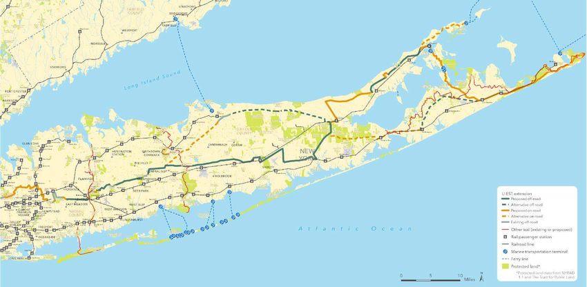
Empire State Trail Long Island Extension Feasibility Study                                               2018

                             Table of Contents

                             The Empire State Trail Highlights
                                                                    Proposed Trail Alignment (27)
                             (6)
                            Background (7)                          Next Steps (43)

                            Project Goals (9)                       Cost Estimate (47)

                             Core Objectives (10)                   Additional Recommendations (49)

                             Biking & Walking on Long Island (11)   Appendix A: Literature Review (54)

                             Process & Engagement (17)              Appendix B: Maps (57)

                             Route Overview & Development (20)

                                                                                                                2
Acknowledgements
Presented by:
                                               Project Team

                                               Trust for Public Land                    The Empire State Trail Extension project was supported with
                                                         Carter Strickland               funding from the New York State Conservation Partnership
                                                         Danny Gold                    Program (NYSCPP) and New York's Environmental Protection
                                                         Grace Healy
                                                                                       Fund. The NYSCPP is administered by the Land Trust Alliance,
                                               New York Bicycling Coalition                in coordination with the New York State Department of
                                                      Paul Winkeller                                    Environmental Conservation.
                                                      Hal Terry                          The Trust for Public Land and New York Bicycling Coalition
                                                      Howie Mann
Prepared by:                                                                            are also indebted to the Long Island Community Foundation
                                               TransPro Consulting                         and Rauch Foundation for their generous support of this
                                                       Dan Suraci, AICP                                            project.
                                                       Lyndsey Scofield, PMP

 Special Thanks
 Nassau County Department of Public Works, Suffolk County Department of Public
 Works, Long Island Power Authority, Long Island Rail Road, Hauppauge Public Library

                                                                                                                                                      3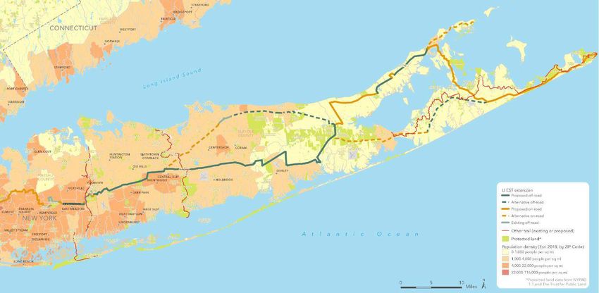
Dear Friends,

The Trust for Public Land creates parks and protects land for people, ensuring healthy, livable
communities for generations to come. Our mission is to connect people to nature -- and in so doing,
connect people to each other. We plan and build green spaces because they improve physical and
mental health, provide cool shade and absorb stormwater, revitalize communities, and facilitate
recreational tourism.

Trails are a great example of how open space provdies many benefits. These “linear parks” allow for a
range of activities, from a healthy commute to a weekend adventure with families and friends, and
can tie together walkable, bikeable, and vibrant downtowns. As Long Island looks to the future, a long
distance trail can help attract and retain residents, businesses, and visitors, and greatly benefit the
seven million people who live in Suffolk, Nassau, Queens, and Kings (Brooklyn) Counties. This report
shows that a trail is possible, even through this densely populated area, and can tie into the Empire
State Trail that will be completed in 2020. We hope that this study inspires further action and the
construction of a world-class trail from New York City through Bethpage State Park, the Pine
Barrens, Greenport, and Shelter Island to Montauk, and all the unique places in between.

Kind Regards,

Carter Strickland
New York State Director
Trust for Public Land
                                                                                                          4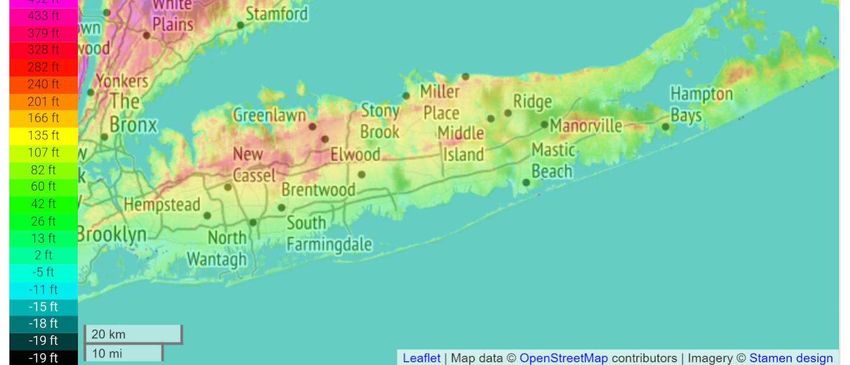
The New York Bicycling Coalition (NYBC) is thrilled to be partnering with The Trust for
Public Land and is committed to identifying a realistic alignment which extends the
magnificent Empire State Trail into Nassau and Suffolk counties. NYBC draws upon nearly
thirty years of experience working in the bicycling, pedestrian and active transportation
space to engage a range of our organization's partners, in both the public and private
sectors, on Long Island to provide valuable feedback and guidance to this important first
stage effort.

We are at the beginning of an exciting and complicated process that will ensure that the
Empire State Trail is not just an end-to-end New York State asset, but will be an irresistible
magnet for global tourism and an engine of sustainable economic development. As we move
in to additional planning, design, fund development and actual build out we are committed
to emulate the approach taken by the Empire State Trail launching in 2020 - identify a
compelling spine for the Long Island Empire State Trail Extension and strive to incorporate
other trails and off-road assets to provide a full range of bike, hike and other active
recreation and transportation opportunities for visitors and the millions of New Yorkers
who reside on Long Island.

Paul Winkeller, Executive Director
New York Bicycling Coalition

                                                                                                 5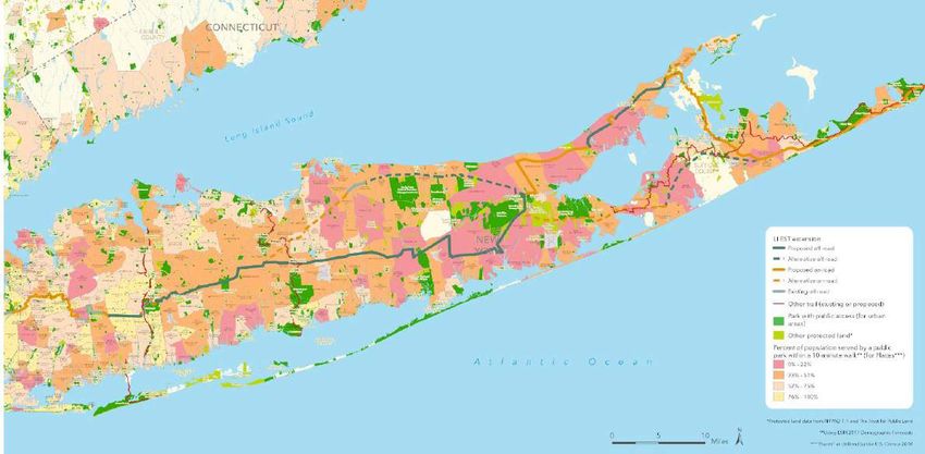
Presented by: Trust for Public Land & The New York Bicycling Coalition                        Prepared by: TransPro Consulting

                The Empire State Trail
                                                                         The Empire State Trail (EST) is the country’s
                                                                         longest statewide trail and represents an
                                                                         unprecedented investment in active
                                                                         transportation and recreation across New
                                                                         York State. The EST is...

                                                                         750          Miles

                                                                         60%            Off-road (approximate)

                                                                         $200M                    Investment
                                                                                                                                 6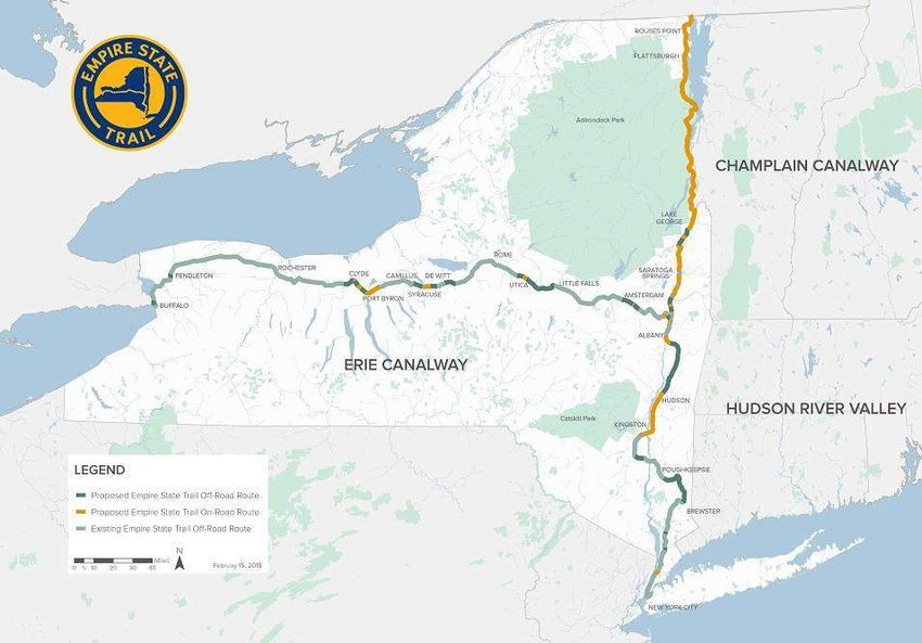
Presented by: Trust for Public Land & The New York Bicycling Coalition                                                           Prepared by: TransPro Consulting

                Background
                   The Empire State Trail (EST), announced early in 2017 during       The purpose of this project is to identify a feasible
                   Governor Cuomo's State of the State message, is a bold             extension of the EST through Long Island and to facilitate
                   vision: a world class multi-use path combining on and off-         public engagement around walking, hiking and bicycling
                   road paths to span from the Canadian borders near both             on the corridor. This proposed trail alignment will take
                   Plattsburgh and Buffalo to New York City. The EST provides         advantage of utility corridors and existing trails to
                   an innovative and uniquely New York response to explosive          maximize off-street segments to the greatest extent
                   interest in bicycling and walking-hiking for recreation, health,   possible. This approach optimizes safety for all users and
                   and sustainability, and in driving local as well as regional       serves a dual purpose as both a recreational asset and
                   economic development through enhanced tourism-related              active transportation corridor.
                   opportunities. While geographically extensive, the EST
                   “ends” at Battery Park at the southern tip of Manhattan,
                   excluding Long Island and the seven million residents of
                   Brooklyn, Queens, Nassau, and Suffolk.

                                                                                                                                                                    7
State and Local Context
A long distance trail is consistent with the          Additional public lands are
New York State Comprehensive Outdoor            needed now to ease the burden on
Recreation Plan because it supports             existing public lands. Long Island’s
outdoor recreation and bringing people          2.8 million residents and 5.1 million
closer to the land to interact with nature      tourists are overburdening Long
and the environment. The planned                Island’s protected open spaces.
recreational off-road biking and walking        Overcrowding is common and user
path will be accessible to everyone and will    conflicts are on the rise… As health
welcome people of varying abilities,            costs soar and the economy falters,
encouraging them to be active in outdoor        public parklands provide inexpensive
recreation. In addition, the State Open         venues      for   healthful  outdoor
Space Conservation Plan prioritizes trails      recreation and peaceful connection to
and greenways for non-motorized travel          nature. Acquisition and development
corridors for people and wildlife and to link   of land for outdoor recreation, such
recreational,    natural     and    cultural    as hiking, biking, horseback riding,
attractions.” According to the Long Island      hunting, fishing, swimming, boating,
Advisory Committee to the Open Space            and more, will ultimately result in a
Plan:                                           lower medical costs and a happier
                                                and healthier public.

                                                                                        8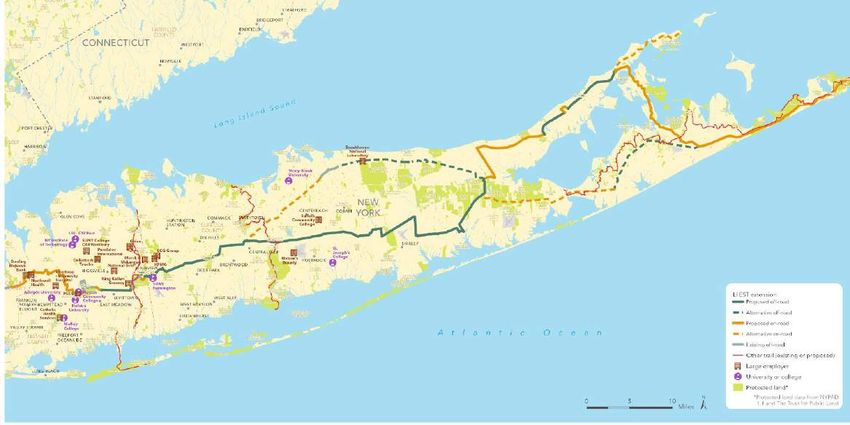
Presented by: Trust for Public Land & The New York Bicycling Coalition                                                                      Prepared by: TransPro Consulting

                                                                           The Trust for Public Land and New York Bicycling Coalition (NYBC)
                                                                           collaborated in this effort to develop a route alignment and identify next
                Project Goals                                              steps. The proposed route was developed to address three primary goals:

                          INCREASE:                                                   FOSTER:                                            PROMOTE:

     Connectivity                                                        Equity & Public                                     Community
                                                                             Health                                           Vitality
        The proposed route will serve                                      The proposed route will be                          The proposed route will take
        as a transportation resource,                                      accessible to all users, and                         advantage of Long Island’s
         connecting communities as                                          promote positive health                             unique parks and cultural
             well as existing trails                                          outcomes via active                              resources to promote active
           throughout Long Island.                                         transportation/recreation.                            recreation and tourism.                       9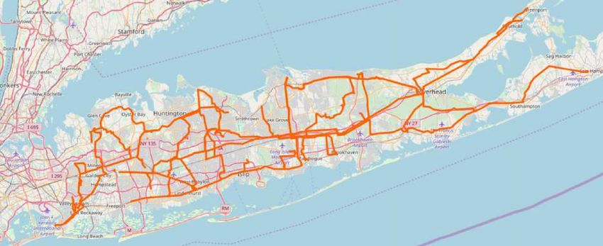
Presented by: Trust for Public Land & The New York Bicycling Coalition                                                        Prepared by: TransPro Consulting

                Project Objectives
                                               Identify a preliminary route alignment         Identify next steps to implementing the
                                    1                                                     3
                                               through Nassau and Suffolk Counties that       proposed Long Island extension to the
                                               maximizes off-road segments.                   Empire Trail.

                                               Identify a connecting route from Battery
                                    2                                                         Catalyze public and private stakeholder
                                               Park (the current terminus of the Empire   4
                                                                                              engagement around active transportation,
                                               State Trail) to the proposed Long Island
                                                                                              tourism and recreation on Long Island.
                                               extension route.

                                                                                                                                                                 10
Empire State Trail Long Island Extension Feasibility Study 2018
Biking & Walking
on Long Island
11Presented by: Trust for Public Land & The New York Bicycling Coalition Prepared by: TransPro Consulting
Biking on Long Island
Overview
Bicycling has been occuring on Long Island since the 1890s. At
that time the bicycle saw increasing use as a practical
transportation solution as well as a recreational option for Long
Islanders. Early partnerships arose between cyclists and the
Long Island Rail Road that enabled cyclists to bring their bikes
from New York City to the roads of Long Island. This relationship
continued until the 1960s when the automobile began to
dominate the transportation landscape.
More recently, in response to recreational demand, biking and
hiking trails have been built within state and local parks, as well
as several north-south routes including the Bethpage Bikeway
and Nassau-Suffolk Greenbelt Trail. The following analysis
provides a snapshot of the current state of bicycling and walking
on Long Island from a variety of sources.
12Overview of Metrics Bike Club Events
Despite a high population density in Nassau and Suffolk Each club has at least one major cycling event during the
and a tight road system that has only begun to address riding season - e.g., SBRA Super Cycling Saturday,
moving toward Complete Street standards that will result Huntington's Gold Coast Tour and CLIMB's Fat Tire Fest
in more and safer bicycling, the current state of bicycling each fall. Other major annual rides - club, cause or private
on Long Island is quite strong. tour operators - on Long Island include the: SBRA Bike
Boat Bike; Massapequa Bicycle Club Tour of the
The combined metrics for the 2018 riding season provided Hamptons; ALS ride; MS Ride; Cystic and Guide Dog
to the New York Bicycling Coalition by five active clubs on Foundation rides; and CycleNY Stony Brookside Tour.
Long Island: Suffolk Bicycle Riders Association; Huntington
Bicycle Club; Massapequa Park Bicycle Club; Long Island
Bicycle Club and Concerned Long Island Mountain
Bicyclists, are illuminating:
Tourism and Recreational Opportunities on Long Island
2550 Active bike club members The tourism industry, promoted by Discover Long Island,
actively promotes bicycle-based tourism. Vision Long
Island's annual Complete Streets conference, involving
3000
Organized bike rides, across all levels of hundreds of local and regional elected officials and key
cycling abilities, on and off road public and private stakeholders, addresses quality of life
issues in Nassau and Suffolk, including road and trail
opportunities on Long Island that respond to a growing
625000 total miles ridden interest in bicycling, walking, hiking and active living.
13Bicycle & Pedestrian Safety on Long Island
According to data from The Institute for Traffic Safety Management
and Research, the total number of bicycle and pedestrians killed or
injured in both Nassau and Suffolk County is well above the state
average (by county). While this does not account for relative
population density - King County, for example, has a higher number of
crashes, but lower rate of crashes relative to population - it does
illustrate a clear need to enhance bicycle and pedestrian safety.
Nassau County has a higher number of pedestrian fatalities or injuries
than Suffolk County. This is likely a function of decreased population
density in Eastern Suffolk County relative to the county’s geographic
size. However, the number of bicycle injuries or fatalities have been
relatively similar in both counties since 2011, suggesting a similar set
of conditions for cyclists in Nassau and Suffolk County. Similar to
pedestrian numbers, bicycle fatalities and injuries are well above the
county average across New York State.
+ Population Density -
According to the NYS Pedestrian Safety Action Plan,
Nassau and Suffolk Counties rank first and third
respectively (outside of New York City) in terms of the total
number of pedestrian crashes. 14● Compared to the state average across all counties, Nassau ● Compared to the state average across all counties,
and Suffolk Counties have consistently had a higher Nassau and Suffolk Counties have consistently had a
number of pedestrians injured or killed since 2011. higher number of bicyclists injured or killed since 2011.
● Nassau County has consistently maintained a higher ● Both counties have maintained similar numbers of
number of pedestrians killed or injured than Suffolk bicycle injuries and fatalities since 2011, with Suffolk
County. County reporting slightly higher numbers.
15The density of bicycle Nassau and Suffolk County Pedestrian & Cyclist Crashes (2014 - 2016)
and pedestrian crashes
is consistent with the
spread of population
density, with the
majority of bicycle and
pedestrian incidents
occurring in Nassau and
western-Suffolk County.
Nassau and Suffolk County Crash Hot Spots (2014 - 2016)
The Nassau County & Suffolk County Crash Maps, created by Tri-State Transportation Campaign, highlight injuries and fatalities between 2014-
2016. These maps were part of their We're Walking (and Biking) Here!analysis released September 2017. 16Empire State Trail Long Island Extension Feasibility Study 2018
Process &
Engagement
17Process
Trail Alignment
The initial trail alignment was developed
with a visual survey of above-ground
01 03
utility corridors and existing bike routes on
Google Earth and utility corridors via
OpenStreetMap Foundation. The route
was then refined and expanded based on
stakeholder input.
Stakeholder Interviews On-Site Survey
The team conducted a series of tactical on-
02
The project team leveraged its extensive
site existing conditions surveys in key
network of grassroots contacts to
challenge areas to determine trail
assemble a robust stakeholder advisory
feasibility. Adjustments to the route
group consisting of bike clubs, hiking clubs,
and/or recommendations for further study
individual advocates, nongovernment
were detailed in the report.
organizations and public agency staff,
including meetings with Long Island Power
Authority and Long Island Rail Road.
18Presented by: Trust for Public Land & The New York Bicycling Coalition Prepared by: TransPro Consulting
Stakeholder Engagement
The Trust for Public Land and NYBC met with more than 60 stakeholders throughout the course of this project. This
includes public agencies, local planning departments, bike-hike clubs and other grassroots interests, as well as
leadership in both Nassau and Suffolk County, including the Long Island Rail Road and the Long Island Power
Authority. The figures below provide a snapshot of the breadth of engagement:
Public Agencies Organizations & Elected Officials Individuals
16 121 60+
Including Nassau and Suffolk Including the Towns of Southampton Three public meetings for public,
County staff as well as Long and Easthampton, Long Island private, NGO and individual
Island Power Authority (LIPA) Association, LI Bldrs Assoc, CLIMB, stakeholders - one preliminary
Vision LI, Discover LI, NYSDOT,
and Long Island Rail Road session in the late spring and two
Carless LI, LI Greenbelt Conf, LI
(LIRR) . county-specific sessions in the
Bicycle Club, GPI, RXR, Suffolk
fall.
Bicycle Riders Assoc, and LI YMCA
19Empire State Trail Long Island Extension Feasibility Study 2018
Route Overview &
Development
20Route Overview
The proposed Long Island Extension to the Empire State available off-road choices; these are concentrated on the
Trail route spans nearly 175 miles connecting five counties less dense East End. The majority of off-road routes in
and 27 communities. The route provides a complete east to Nassau and Suffolk county take advantage of LIPA utility
west connection from Battery Park in Manhattan through corridors to maximize the route’s off-road mileage
the center of Long Island to the north and south forks, throughout Nassau and Suffolk Counties. While the focus
terminating in Montauk. This path connects several of this study was a route through Nassau and Suffolk
existing north to south trails that intersect the proposed County, the Trust for Public Land and NYBC also developed
route, including the Bethpage Bikeway, Nassau-Suffolk a connecting route from the current terminus of the EST in
Greenbelt Trail, and the Long Island Greenbelt Trail. It also Battery Park, through Brooklyn and Queens to the Nassau
connects many parks that have internal trail systems, as County border. We also identified an alternative route
well as the Paumanok Path, providing even greater access (indicated with dashed lines on the map), that warrants
to active recreational and transportation corridors. In further investigation as an additional shared use trail with
keeping with the design of the Empire State Trail, the recreational transportation and tourism potential. The use
proposed route emphasizes off-road trails (indicated in of LIRR corridors should be studied, as there are many
green on the map) where possible, and especially where successful existing “rail with trail” corridors throughout the
necessary for safety. It also includes on-street connections U.S. that could serve as a model. These corridors could
(indicated in yellow on the map) when there are no provide more direct, off-road routes in key locations.
21Presented by: Trust for Public Land & The New York Bicycling Coalition Prepared by: TransPro Consulting
In January 2017, Governor Cuomo local governments, engineering design
announced the Empire State Trail, a firms, and trail organizations charged
new initiative placing New York State with designing, building, and operating
at the forefront of national efforts to segments of the Empire State Trail. This
Empire State enhance outdoor recreation,
community vitality, and tourism
document provides a comprehensive
summary of the current guidelines for
Trail Plan & development. Approximately 400 miles
of the Trail already exists in discrete
developing off-road “shared use paths”
and on-road bicycle and pedestrian
Design but still disconnected segments. When
completed by the end of 2020, the
routes. The Design Guide builds upon
bicycle and pedestrian guidelines issued
Standards Empire State Trail will be a continuous
750-mile route spanning the state from
by the American Association for
Highway and Transportation Officials
New York City to Canada and Buffalo (AASHTO), which is the national
to Albany, creating the longest multi- standard for multi-use trail facilities.
use state trail in the nation. The trail’s
current southernmost terminus is This project and proposed trail
Battery Park in Manhattan, excluding alignment was created with these trail
Long Island. standards in mind to ensure that a fully
built out New York State “end-to-end”
An Empire State Trail design guide was trail adheres to these guidelines in the
prepared to help guide state agencies, future.
22Presented by: Trust for Public Land & The New York Bicycling Coalition Prepared by: TransPro Consulting
Transforming Utility Corridors to Trails
The Long Island Power
Authority (LIPA) owns or
operates a significant network
of linear above ground rights of
way (ROW) for its transmission
lines. The linear nature of these
corridors and open ground
space make these corridors
ideal for mixed use paths. The
map to the left outlines the map
of both elevated and below-
ground utilities throughout
Courtesy of OpenStreetMap Foundation Nassau and Suffolk County.
23Presented by: Trust for Public Land & The New York Bicycling Coalition Prepared by: TransPro Consulting
Shared Use Paths in Utility Corridors
One of the core elements of this Empire
Trail Extension feasibility study is an San Jose, CA Arlington, Fairfax, Loudoun Counties, VA Cape May, NJ
alignment that maximizes off-street
Albertson Washington and Middle Township
segments to enable a safer, more enjoyable
user experience for all Long Islanders and Parkway Trail Old Dominion Trail Bike Path
visitors. Shared use paths in utility
corridors have been designed and
implemented across the country, in New
York State, and even on Long Island. This
report presents two case studies to discuss
the challenges, opportunities and
precedent for sharing mixed-use paths
with utility corridors: the Albany-Hudson
Electric Trail (a planned segment of the
Empire State Trail) and the Port Jefferson
to Wading River Trail under construction
in Suffolk County. Successful examples of utility trails across the country include the Washington and Old Dominion
Trail (VA), Middle Township Bike Path (NJ) and Albertson Parkway Trail (CA).
24Suffolk County, Overview & Scope: Liability:
Suffolk County first began discussing the
NY This 10-mile trail will connect Port Jefferson
project in the 1970s, but there was little
Port Jefferson Station, Mount Sinai, Miller Place, Sound Beach,
Rocky Point, Shoreham and Wading River and
movement until the original Rails to Trails
path was proposed in 2001 by advocates
to Wading would feature kiosks at trailheads, quarter-mile
markers and railings on inclines. This trail also
of the Setauket-Port Jefferson Station
Greenway Trail. One of the most
River Trail provides bicycle and pedestrian connectivity to
numerous hamlets, downtowns and cultural
challenging barriers to advancing this
project was the question of liability on
assets -- most notably, the Tesla Science Center,
non-county-owned property. Suffolk
a museum at a former laboratory in Shoreham.
County negotiated an agreement that
The trail is situated in a former rail right of way
indemnifies LIPA from user-related
abandoned since 1938 that is owned and used by
liability. This particular multi-use path
LIPA. The trail is in its final design phase and the
provides important precedent for the
county plans to release a bid for construction in
Empire Trail extension as it establishes a
late 2018, with a contract expected to be
legal framework for additional mixed-use
awarded by the end of the year. Construction is
utility corridor paths in in Suffolk County.
anticipated to begin in early 2019.
In addition, this trail lays the foundation
Funding: for a similar agreement between Nassau
This trail will cost $882,000 per mile. The federal County and LIPA that will be a critical
government will fund 94 percent of the project factor in advancing the proposed Long
($8,320,000) under a Surface Transportation Island Extension to the Empire State Trail
Program grant and the County will fund the route.
remaining 6 percent ($500,000) for a total
project cost of $8,820,000.
25Overview & Scope: Trail Maintenance:
Rensselaer & Columbia, NY The Empire State Trail already uses utility The AHET Trail will be operated and
Albany- corridors for some segments. The Albany-
Hudson Electric Trail (AHET) will be a
maintained by a collaborative partnership
including the Hudson River Valley
Hudson shared-use bicycling and pedestrian trail
along the 35-mile Albany-Hudson Electric
Greenway, local county, town and village
governments, and interested trail groups
Electric Trail Trolley corridor from Hudson, NY to
Rensselaer, NY. When complete, this trail
and volunteers. The Greenway/New York
State retains responsibility for long-term
will be integrated into the Empire State Trail capital maintenance such as resurfacing
network. The AHET Trail crosses through with asphalt and stonedust or replacement
two counties (Rensselaer and Columbia), of safety fencing (typically once every 15+
eight towns, and five cities and villages. At years). Local governments will assume
the northern end, the trail begins near the responsibility for the maintenance of the
Albany-Rensselaer Amtrak station. At the trail within their jurisdictions. Volunteer
southern end, the City of Hudson provides a maintenance efforts may be organized
trail destination with shops, galleries and under the umbrella of each municipal entity.
restaurants in a vibrant historic downtown. Any local government and/or non-profit
Combining both on and off-road segments, organizations accepting responsibility for
the off-road sections of the trail are being maintaining sections of the AHET Trail will
developed on a utility corridor owned by be required to provide insurance and
National Grid, which maintains electric liability protection to National Grid. The
transmission lines and associated Long Island Extension to the Empire State
infrastructure along the corridor (formerly Trail project will require a similar plan for
an electric trolley route). maintenance across both counties and local
jurisdictions. 26Empire State Trail Long Island Extension Feasibility Study 2018
Proposed Trail
Alignment
27Setting the Stage: Empire State Trail Extension Overview The proposed Long Island Extension to the Empire State Trail maximizes off-street opportunities by capitalizing on existing trails and utility corridors. The following analysis explains how the route was optimized to increase connectivity, foster equity, and promote active recreation. 28
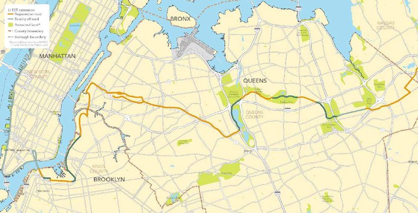
Proposed Long Island Extension to the EST

                                            29
Proposed Route: Battery Park to Nassau County
30Presented by: Trust for Public Land & The New York Bicycling Coalition Prepared by: TransPro Consulting
Route Highlights
Counties Communities* Miles**
5 27 175
Suffolk New York City, Town of Brookhaven, From Battery Park to
Nassau East Hampton, Town of Easthampton, Montauk
Queens Garden City, Greenport, Hempstead,
Kings Huntington, Islandia, Islip, Lake Grove,
New York Lake Success, Mineola, North Haven,
North Hempstead, North Hills, Oyster
Bay, Riverhead, Russell Gardens, Sag
Harbor, Shelter Island, Smithtown,
Southampton, Southold, Westbury,
Williston Park
*Communities is defined as census places as designated by the US Census Bureau. 31
**Mileage is approximate.Presented by: Trust for Public Land & The New York Bicycling Coalition Prepared by: TransPro Consulting
Route Highlights
87 Miles 86 Miles
On-Road Off-Road
*Some on-road routes, while still within the street right of way, are designated as
“protected” bike lanes. These are physically separated from traffic, thus providing
similar safety accommodations to off-road trails.
32Access to Institutions & Employment
The proposed route alignment transects a dense concentration of
more than fourteen (14) of the largest employers and six (6)
educational institutions in Nassau County and runs proximate to
others throughout Suffolk County. The 61,000 college students near
the proposed route or connected trails represent a significant and
likely trail user base.
33Transit Connectivity
The proposed empire trail extension route provides access to rail and bus
facilities. Ferry connections provide a critical linkage between the North and
South Forks on the proposed trail. Future phases of trail implementation will
make recommendations to facilitate trail connections through amenities and
wayfinding assets.
34Population Density
Population density increases from east to West across Long
Island. The proposed trail alignment transects the most
densely populated areas of Nassau and Suffolk County.
35Presented by: Trust for Public Land & The New York Bicycling Coalition Prepared by: TransPro Consulting
Park Equity
Most Long Island residents live more than a 10 minute walk from
from parkspace. The proposed trail alignment not only creates new
publicly accessible open space, but provides connections between
major parks, many of which have internal trail systems, and existing
north-south multi-purpose trails.
36Presented by: Trust for Public Land & The New York Bicycling Coalition Prepared by: TransPro Consulting
Long Island Topography
Long Island is consistently flat and low in elevation. The highest
elevation on Long Island (Bald Hill, Farmingville) sits at 331 ft
above sea level, and the proposed route avoids this area as well
as other hilly areas. The flat route presents fewer mobility
barriers to cyclists and pedestrians.
37Presented by: Trust for Public Land & The New York Bicycling Coalition Prepared by: TransPro Consulting
Segment 01:
Nassau County
Total Off Road: 10.3 Miles
Total On-Road: 16.7 Miles
Nassau County’s Motor Parkway Trail Vision Plan, published in
2012, proposes a plan to redevelop portions of the Long Island
Motor Parkway into a mixed use path for bicycling and walking.
The proposed route in Nassau County uses the 2012 study
recommendations, following the same alignment from the
Queens border to Eisenhower Park. The proposed EST route
takes advantage of existing trails in Eisenhower Park, before
continuing eastward in a LIPA-owned utility corridor toward
Bethpage State Park where the route intersects the Bethpage
Bikeway and Nassau-Suffolk Greenbelt Trail. This section of the
proposed route aligns closely with key Long Island Rail Road
stations including Mineola, Carle Place, Westbury and Country
Life Press as well as Little Neck on the Port Washington Branch.
38Presented by: Trust for Public Land & The New York Bicycling Coalition Prepared by: TransPro Consulting
Segment 02:
Suffolk County West
Total Off Road (all Suffolk County): 50.5 Miles
Total On-Road (all Suffolk County): 0 Miles
From Bethpage Park, the proposed EST Extension This segment of the proposed trail parallels LIRR’s Ronkonkoma
route continues east into Suffolk County in off-road Line with direct access to Yaphank and Riverhead stations. All
utility corridors. The route passes Long Island National other stations are within five miles of the proposed route.
Cemetery and intersects existing trails in Butterfly
Park and Strathmore Park before continuing through
the Edgewood Oak Brush Plains Preserve. The trail
continues in utility corridors parallel to the long Island
Expressway (Route 495) before entering Southaven
County Park. The route then turns south at Weeks
Ave, following a utility corridor, before continuing east
along Sunrise Highway (Route 27). The proposed
alignment continues in a utility corridor parallel with
Moriches-Riverhead Rd before a sharp turn North in
the Peconic Hills County Park.
39Presented by: Trust for Public Land & The New York Bicycling Coalition Prepared by: TransPro Consulting
Segment 03:
Suffolk County East
The remainder of the route runs on-road through Shelter Island and
Total Off Road (all Suffolk County): 15.4 Miles
North Haven leveraging Ferry connections in between. This portion
Total On-Road (all Suffolk County): 52.7 Miles
of the proposed route runs proximate to the Southold and
The route crosses the Peconic River at Middle Country
Greenport stations on the Long Island Rail Road’s Ronkonkoma
Road, where it turns east and transitions on-road along
Branch as well as three stations on the Montauk Branch (East
NY State Route 25. It then turns north northwest on
Hampton, Amagansett and Montauk stations).
Roanoke Ave before heading east on Sound Avenue.
The route turns on Cox Neck Road before crossing the
Mattituck Inlet. While the routing across or around the
inlet requires further study, the proposed trail
alignment picks up on the east side, following a utility
corridor. There is a brief on-road spur north on Depot
Lane which turns east on Oregon Road and then south
on Cox Lane before returning to the utility ROW. This
ROW will require further study to determine the
extent of private property easements along the
corridor. The route links with Main Road and continues
to North Ferry Terminal. 40Presented by: Trust for Public Land & The New York Bicycling Coalition Prepared by: TransPro Consulting
The Brooklyn-Queens Connection
Total Off Road: 10.5 Miles
Total On-Road: 18.3 Miles
The route begins in Battery Park and continues up the east
side bike path in Manhattan, before connecting with the
Manhattan Bridge bike path. In Brooklyn, the route turns east
in a separated off-street bike path on Sands Street. The route
shifts into a southbound bike lane on Navy Street before
turning north into a bike lane on Flushing Ave. At Kent
Avenue, the route transitions into a fully protected off-street
route heading north. At North 14th Street, the route becomes onto Queens Blvd. At Jewel Avenue, the route turns into
a bike lane on Franklin Avenue. The route turns onto Eagle Flushing Meadows Park where it continues northeast. The
Street (or Freeman Street if heading westbound) before route continues in a bike route along Kissena Corridor Park
crossing the Pulaski Bridge. Now in Queens, the route before moving off-road through Kissena Park. The route stays
continues in a bike lane on 11th Street before turning east on east on Underhill Avenue before heading off-road in
44th Drive and north on Vernon Blvd. The route then turns Cunningham Park. The route continues off-road in the
east at Queens Plaza following a protected bike lane to Brooklyn-Queens Greenway before turning north along Alley
Skillman Avenue. The route continues in a bike lane on 43rd Pond Park. The route turns east at Northern Blvd before
Avenue (or Skillman Avenue if heading westbound). The route turning north on 247th Street and finally east again on low-
turns south on 50th Street (or 51st Street if heading traffic streets to the Nassau County border. 41Presented by: Trust for Public Land & The New York Bicycling Coalition Prepared by: TransPro Consulting
Alternative Suffolk County Trail
Total Off Road: 31.9 Miles
Total On-Road: 38.6 Miles
An alternative route (indicated in dashed lines on the map)
diverts northward to take advantage of major parklands and
recreational assets such as Rocky Point Pine Barrens State
Forest, Calverton National Cemetery and the Peconic Bog
County Park. This portion of the route combines on and off-
road segments currently in various phases of design and
construction. This includes the Port Jefferson to Wading
River Utility Trail (noted in detail on page 25 of this report)
and NYSDOT’s safety and mobility improvements on NY
Route 347. This mileage is not included in the other Hills where it turns North into a utility corridor in South
calculations of the recommended route, but runs 70.5 miles in Hampton. This corridor requires further study to determine the
total. It would not link with more densely populated portions feasibility of a trail in light of numerous private property
of the county. The alternative route diverts south before easements along the utility corridor. In addition to this
turning east in an on-road trail running through the Sarnoff southern route, NYBC and The Trust for Public Land
Preserve and Maple Swamp County Park. The route then investigated the possibility of an on-road spur from the
heads east on the Montauk Highway crossing into Shinnecock proposed route on the north fork to Orient Point.
42Empire State Trail Long Island Extension Feasibility Study 2018
Next Steps
43Paving a Path Forward: Next Steps to Extend the Empire State Trail The Long Island Extension to the Empire State Trail will require a detailed design study. As a first step, we recommend a detailed feasibility study of a segment of moderate length and cost that can be a pilot project for full build out of the entire route and adoption into the Empire State Trail network. 44
Presented by: Trust for Public Land & The New York Bicycling Coalition                                                   Prepared by: TransPro Consulting

                                                                                          Nassau County Route Segment
                Recommended Pilot Project
                                                                                             START
                Eisenhower to Oak Brush
                Plains Preserve
                As an immediate follow up to this feasibility study, The Trust for
                Public Land and NYBC recommend the implementation of a pilot
                section of the route between Eisenhower Park and Bethpage State
                Park in Nassau County and between Bethpage State Park and
                Edgewood Oak Brush Plains Preserve in Suffolk County. This route          Suffolk County Route Segment
                spans approximately 21 miles and is a combination of utility corridors
                and off-street paths. This 21-mile route has independent utility as it                                           FINISH
                also connects three state parks and Long Island National Cemetery,
                but it is also a proof-of-concept for the full 175-mile Long Island
                Extension to the Empire State Trail. The estimated implementation
                cost for this pilot is approximately $20 million, based on cost figures
                from the Port Jefferson to Wading River trail project and a 20%
                margin for planning and design. The next step will be a detailed
                planning study of this route, including extensive on-site surveying and
                route verification as well as an implementation and operations plan.                                                                        45
Prospective Timeline
Study of Long Island
Extension to the Empire Opening of the Empire State Trail Design, Construction, and Operation
State Trail of Long Island Routes
2019 2021
2018 2020 Ongoing
Initiation of Proposed Pilot Integration of Long Island
Project in Nassau & Suffolk Extension into the Empire
County State Trail
46Empire State Trail Long Island Extension Feasibility Study 2018
Cost Estimates
47Presented by: Trust for Public Land & The New York Bicycling Coalition Prepared by: TransPro Consulting
The cost for this proposed Empire State Trail Extension route alignment in Nassau
Preliminary Cost and Suffolk County was estimated using figures from the Port Jefferson to Wading
River trail project, and in consultation with EST project managers working on the
Estimate formal 2020 launch. As a utility trail in the region, the Port Jefferson-Wading River
project provides a good cost comparison. The cost for mile for on-road routes is based
on the national average cost of similar projects. Including a 20% margin for planning,
and engineering, the total estimated cost for this project is $114 Million.
Utility Corridor Conversion On-Road Route Conversion Cost Total Estimated Implementation
Construction Cost Per Mile: Per Mile: Cost
$882K $25K $114M
Cost per mile based on the Based on national average Includes engineering and construction
Port Jefferson to Wading cost per mile for signed bike of the proposed route in Nassau and
River project’s reported cost. routes. Suffolk Counties. Excludes routes in
Manhattan, Brooklyn and Queens as
well as existing trails in Nassau and
Suffolk County. 48Empire State Trail Long Island Extension Feasibility Study 2018
Additional
Recommendations
49Maximizing the Trail: Additional Recommendations to Optimize Trail Utility
The Long Island Extension to the Empire State
Trail represents an opportunity to enhance
active transportation and recreation across
Long Island. The following recommendations
are designed to maximize the proposed trail’s
utility, beyond the scope of implementation.
50Presented by: Trust for Public Land & The New York Bicycling Coalition Prepared by: TransPro Consulting
Additional Recommendation
Secure Bike Parking
The proximity of the proposed trail to LIRR facilities presents an
opportunity to facilitate first and last mile connections with
transit. This not only provides transit commuters with an
alternative to driving, but can extend the reach of transit to
communities without access to cars. It can also facilitate tourism
by enabling visitors to leverage transit connections to access
different sections of the Long Island Extension to the Empire
State Trail. From an operational perspective this can help
decrease demand for automobile parking at transit stations and These facilities empower transit customers by providing
potentially increase ridership. Transit agencies across the a safe, secure place to park one’s bicycle for the day.
country have observed tremendous success in providing Unlike conventional open-air bike racks or bike lockers,
customers with multimodal linkages. The bicycle is ideal for short secure bike cages can hold a high volume of bikes in a
trips of one to three miles and can provide an inexpensive, relatively small space. NYBC and The Trust for Public
healthy, carbon-neutral option for commuting. One of most Land recommend the installation of two secure bike
successful strategies for facilitating this connection is with secure parking cages at LIRR stations in Nassau and Suffolk
bicycle parking facilities at transit stations. County that have a high demand for automobile parking.
51Presented by: Trust for Public Land & The New York Bicycling Coalition Prepared by: TransPro Consulting
Additional Recommendation
Local Wayfinding
Wayfinding and related signage is a major asset in tying trail
segments together. As the trail is implemented, The Trust for
Public Land and NYBC recommend a comprehensive wayfinding
plan which adheres to the standards set forth in the Empire State
Trail Design Guide. This will include:
● Branded wayfinding at trail heads.
● Context maps including current location and local
community.
● Periodic wayfinding signs for on-road routes.
● Periodic mileage markers.
● Rules of conduct posted in appropriate locations.
In addition to wayfinding maps, The Trust for Public Land and
NYBC recommend working with local tourism agencies to develop
local informational kiosks attracting trail users to downtown
areas and resources.
52Presented by: Trust for Public Land & The New York Bicycling Coalition Prepared by: TransPro Consulting
Additional Recommendation
Designated Campgrounds
Reserved campgrounds for cyclists promote bicycle tourism by
providing specific amenities such as bike racks and repair trees
(complete with pumps, a repair stand and secured tools).
These campgrounds offer a more intimate camping experience
without interference from automobiles, RVs and pop-up
campers.
The Trust for Public Land and NYBC recommend that
campgrounds in state and county parks near the trail allocate
reserved space for cyclists with these amenities.
53Appendix A: Literature Review
54Overview
The New York State Empire Trail Design Guide provided
The team consulted many sources as inputs to this project.
specifications for trail design, color coding on maps and other
These sources provided background information on a range of
important guidelines.
topics addressed in this study including existing trails, utility
corridors, development strategy, economic benefits of tourism,
The OpenStreetMap Foundation’s website showed Long Island
detailed maps of Nassau and Suffolk County bikeways,
Power Authority utility lines which was used to identify potential
community outreach and implementation considerations.
utility corridors.
Sources include:
● New York Metropolitan Transportation Council
The Long Island Index’s website provided interactive maps
● Regional Planning Association
displaying the region’s data and characteristics including
● New York State Empire Design Guide
housing, land use and utility routes.
● Long Island Index
● Rails to Trails Conservancy
Newspapers including the Suffolk Times, Newsday and
● Planning documents from Nassau and Suffolk Counties
Riverhead News had many stories about the Wading River to
● NYS Department of Transportation
Port Jefferson utility trail.
● Long Island Greenbelt Trail Conference
● American Trails
Bikeitorhikeit.org provided detailed maps of on-road and off-
road shared paths in Nassau and Suffolk Counties.
Document Summaries
The New York Metropolitan Transportation Council’s Plan 2045
Rails to Trails Conservancy has many articles on utility trails
published in 2017 described Nassau and Suffolk pedestrian
that were very useful in providing examples of current trails and
and bicycle paths and included a list of “Vision Projects”.
other practical information.
The Regional Planning Association’s Fourth Regional Plan
Suffolk County’s Comprehensive Master Plan 2035 published
published in 2017 included recommendations for Nassau and
Suffolk trails. in 2015 provided plans for economic growth, transportation
initiatives and housing.
55Nassau County’s Motor Parkway Trail Vision Plan published in Florida Power and Light Greenway proposal in 2004 is a
2012 contains a detailed analysis of the Vanderbilt Parkway comprehensive shared use corridor study including a
and became a major part of our report’s proposed trail. discussion of utility corridors, community outreach and
implementation considerations.
Connect Long Island published in 2011 described a regional
transportation and development strategy. APTA’s Bicycle and Transit Integration Guide provides detailed
information on bicycle parking at transit facilities as well as
The Trust for Public Land’s Report on the Economic Benefits connecting with both bus and rail transit.
and Fiscal Impact of Parks and Open Space in Nassau and
Suffolk Counties published in 2010 describes how parks and
open space reduce the cost of government services, increases
tourism and promotes health benefits.
The Long Island Non-Motorized Transportation study by the
NYS DOT and NYMTC from 2007 included 113 proposed
corridors and details on 10 prioritized segments.
The Long Island Greenbelt Trail Conference maps provided
details on significant Suffolk County trails.
American Trails article on Using Utility Corridors for Trails
published in 2004 is an informative article about issues and
concerns for utility trails.
56Appendix B: Route & Data Maps
57Amawalk Fishing Muscoot
MIDDLESEX
A s p et
Access Area
I n d i a n R iv
East
BRANFORD
Angle Fly
Muscoot
Mount Holly
Sanctuary
Lewisboro
EAST HAVEN ¤
£
1 COUNTY
u ck R i v e
Fishing
r
Town Park
NEW WEST HAVEN
e
Access Area Cross River
Riv e
O y s te r R iv
C r os s
¤
£
Muscoot Farm Fishing
e
r
7
HAVEN
Pe
r
County Park Access Area
qu
r
John Jay on
Homestead
Ward Pound n COUNTY
N o rw
New Croton Ridge
oc
County Park Onatru
Fishing TRUMBULL
k
Farm Park
Access Area
Ri v
WESTCHESTER
alk
r
er
MILFORD
e
COUNTY
Mi ll R iv
Rive r
k River
Piney
Woods
Preserve
STRATFORD
a tu c
FAIRFIELD
ug
COUNTY
Sa
Arthur
BRIDGEPORT
W. Butler
Sanctuary
Mianus River
Gorge
Preserve
Mianus
Eugene And Agnes
River FAIRFIELD
Meyer Preserve
Gorge Long Beach Bay
Tidal Wetlands Area
Wampus Pond
County Park
WESTPORT
Orient Beach
¤
£ 1
Whippoorwill
Ridge Park
CONNECTICUT NORWALK
§
¦
¨ 95
r
Big
Mia n u s R
m R iv e
er
Peninsula
ro to n R iv
Montauk
Pipes Cove
County Park
Ri p p o w a
Underwater Montauk Point
Lands
iv e
Louden Point Camp
Kensico Hero
r
No
Fishing
Access Area Montauk
Mashomack Amsterdam
Goldsmiths Downs Beach
Inlet County Park
STAMFORD Shadm oor
d
o un Hither Woods
d S Grace
lan
Estate Town Hither Hills
Preserve
Is
§
¦
¨
Linda Gronlund
ng
Memorial Nature
287 Preserve At Barcelo
Lo
Foster Napeague
Morton National Memorial Sag Harbor Dennistown
Wildlife Refuge Town Beach Bell Park
PORT CHESTER Jamesport
Saxon Woods
County Park
Mcallister
HARRISON County Park
(undeveloped) Wading River
Playland Flax Pond Tidal
Marsh Wildwood
County Park Wetlands Area
Preserve
Little
Marshlands Bay Tidal
Conservancy Wetlands Area
(County Park)
Rocky Point Calverton
Natural Resource National
Management Area Cem etery
Caumsett Target Rock
National Crab Brookhaven
§
Long Beach
¦
¨
Wildlife Refuge Meadow
Alfred E. Town Park Peconic Bog
Park
Centre
Smith/sunken Firemens 495 County
Meadow Short Beach Memorial Park
Mill Neck Island Beach East Farm
Town Park Park Maple
County Village Park Preserve
Nissequogue David A. Swamp
Preserve Ridge Environmental County Park Red Creek
River Educational Center Robert Sarnoff Pine
Oyster VA M edical Park
Cushman Murphy Otis Pike Peconic Barrens Preserve
Bay National Center
Sagamore County Park Preserve Hills
Welwyn Wildlife Refuge
Hill National County Park
County Kings Park
Preserve Historic Site Daniel R.
Natural Henry'S
Resource Area Davis Sanctuary Hollow
Long Island
Planting Pine Barrens Preserve
Fields
CENTEREACH CORAM West Hampton
Sands Point
Garvies Point
County
GLEN COVE Arboretum
Uplands Farm
Management Area
County Park Dwarf Pine
Preserve Preserve
COMMACK SMITHTOW N Barrens Pine Neck
er
Preserve
Froehlich HUNTINGTON Caleb Smith Bald Hill Preserve
Riv
County Cultural
Farm STATIO N SUFFOLK Park Preserve
Park
st
Trail View Blydenburg Lake Ronkonkoma
Ea
Hempstead County Park
Harbor
County Park
Muttontown
County
Stillwell Woods
County Park COUNTY County
Park
Preserve
DIX HILLS Islip Greenbelt
County Preserve
Kings William Cullen
Point Bryant County Twelve SHIRLEY Havens
Point Tidal
Town Park Preserve Lakeland Pines
Washington Wetlands Area
NASSAU Terrace County
Park CENTRAL ISLIP
County
Park Holbrook Park
Park
Alley
Morley
County
Park
COUNTY
Cantiague
County
HICKSVILLE
PLAINVIEW
Old Bethpage Village
Restoration County Park
§
¦
¨ 495
Edgewood Oak
Brush Plains
Preserve
BRENTWOOD
Central
Islip Town
Hospital Fields
Connetquot
River
HOLBRO OK
Sans Souci
Wertheim
National
Wildlife Refuge
Park Fireplace
Pond
Park
Battle Row DEER PARK County Park
Neck Tidal
County Park Bayard Wetlands Area
Long Island Johns Neck
Cutting
National Tidal Wetlands
Arboretum
Cem etery
Eisenhower Smith Point Area
QUEENS County Park Bethpage County Park North
(undeveloped)
COUNTY Mitchel LEVITTOWN Pickman-rimmer
Tidal Wetlands Area
County
Park Belmont Lake Timber Point Tidal
FRANKLIN EAST MEADO W WEST ISLIP Seatuck National
Wetlands Area
ELMO NT SQ UA RE HEMPSTEA D Wildlife Refuge Heckscher
WEST BABYLON
NEW YORK
Massapequa Isbrandtsen
County Marsh Tidal Great South Bay
Preserve Wetlands Area Underwater Lands
Hempstead
LINDENHURST (bluepoints)
Valley Stream Lake Roosevelt
VALLEY STREAM
Preserve
County Park
Millpond
LI EST extension
FREEPORT County Park
Brookville Morgan
Proposed off-road
Park
Idlewild
Days Park Newbridge
Road
Merrick Road Park
Cedar Creek
County Park
Fire Island
National S eashore
A t l a n t i c O c e a n
Park OCEA NSIDE Town Park and
Golf Course
Wantagh
County Park
Babylon Marsh-elder
And Petteanger
Alternative off-road
North Woodmere Isl Twa Captree
County Park Cedar Gilgo
Bay County
Baldwin
Cow Meadow
County Park
Beach
Park Proposed on-road
Park Robert Moses
Park
John F Kennedy Tobay
Alternative on-road
Memorial Wildlife Beach
Sanctuary Park
Existing off-road
Rockaway Lido Beach Jones Beach
Park LONG BEACH Tidal
Wetlands Area
Long Beach
Park
Other trail (existing or proposed)
Protected land*
±
*Protected land data from NYPAD
0 5 10 1.1 and The Trust for Public Land
Miles
Long Island Empire State Trail (LI EST) extension
January 8, 2019. Copyright © The Trust for Public Land. The Trust for Public Land and The Trust for Public Land logo are federally registered marks of The Trust for Public Land.
Information on this map is provided for purposes of discussion and visualization only. www.tpl.orgRiverside
Park
Randalls
LI EST extension
Proposed on-road
Island
Park
§
¦
¨
295
Existing off-road BRONX
Protected land* Central Park
NASSAU
Wards
COUNTY
County boundary
Island
Park
§
¦
¨678 Clearview
Park and
Golf Course
Borough boundary Astoria
Park
*Protected land data from NYPAD
1.1 and The Trust for Public Land
G505
MANHATTAN
U
V9A
Al
U
V
ley
495
U
V re
C
25A ek
NEW YORK
COUNTY
U
V25A QUEENS Douglaston
Park
U
V
25
Flushing
Meadows
Kissena
Corridor
West
Corona Park
Alley
Kissena Park Pond
Park
VA Medical
Center QUEENS §
¦
¨495
COUNTY U
V
25B
Cunningham
Park
Hudson
River
U
V25
Park
East
River Juniper
Park Valley Park U
V
25
NEW YORK MANHATTAN QUEENS
U
V
24
ELMO NT
KINGS
COUNTY Forest Park
BROOKLYN
§
¦
¨ 478
§
¦
¨278
BROO KLY N
Roy Wilkins
Highland Park Southern
Queens Park
±
Baisley
Pond 0 0.55 1.1
Park
Miles
Red
Hook Park Prospect Park
LI EST extension, connection to planned Empire State Trail
M A N H A T T A N / B R O O K LY N / Q U E E N S , N E W Y O R K
January 8, 2019. Copyright © The Trust for Public Land. The Trust for Public Land and The Trust for Public Land logo are federally registered marks of The Trust for Public Land.
Information on this map is provided for purposes of discussion and visualization only. www.tpl.orgLI EST extension
Proposed off-road
Alternative off-road
Proposed on-road
Alternative on-road
Existing off-road
Other trails (existing and proposed) d
u n
Protected land* S o
*Protected land data from NYPAD n d
1.1 and The Trust for Public Land s l a
I
n g
L o
Centre
Mill Neck Island Beach
County Village Park
Preserve
Oyster Bay National
Wildlife Refuge
Welwyn Sagamore
County Hill National
Preserve Historic Site
GLEN COVE
Planting
Fields
Garvies Point Arboretum
Sands Point County
County Preserve
Park
V
U 25A
Trail View
Stillwell
Hempstead Woods
Harbor County Park
County Park
Manhasset Bay Muttontown
V
U
101 County
Preserve
V
U 107
V
U 106
V
U 25
Kings
Point Town William
Park Cullen Bryant
County Preserve
Little
Neck NASSAU
Bay COUNTY Washington
Terrace
County Park
§
¦
¨
Morley
County
Park 495
PLAINVIEW
V
U
25A
Cantiague
County Old Bethpage
Park Village Restoration
County Park
HICKSVILLE Battle
Row County
Park
V
U
25B V
U 135
Bethpage
Eisenhower
County
Mitchel
County
Park
LEVITTOWN V
U 109
Park
EAST MEADO W
FRANKLIN HEMPSTEA D
ELMO NT SQ UA RE
V
U 102
V
U 24
Massapequa
County
Preserve
Hempstead
Lake
V
U
105
Seaford Cre e k
re e k
Valley
Stream
V
U
27A
Mil lbur n C
Roosevelt
Preserve
County Park
Millpond
County
VALLEY STREAM
V
U 27 Park
Ced
Morgan
Days
Park
FREEPORT Great
South
ar
Newbridge
Bay
Creek
Road
Park Wantagh
County Seamans
Merrick Road Park Neck Park
Town Park and
North Golf Course
Woodmere OCEA NSIDE Cedar Creek
County Park County Park
Merrick Bay
Cow Meadow East South
Bay County Freeport County Park
Bay Oyster Bay
Park
Baldwin
Bay Hudson Bay
Hewlett Bay Park
Baldwin Bay
V
U 878
Middle Bay
Broswere Tobay
Beach Park
Bay John F Kennedy
Memorial Wildlife
Sanctuary
Zachs Bay
Jones Bay
Lido Beach Tidal
Wetlands Area
LONG BEACH Lido Nassau Point Jones Beach
Beach Lookout
Silver Point Beach Town Town Park
County Park Park County Park
Long Beach
Park
A t l a n t i c O c e a n
0 1 2
Miles ±
Long Island Empire State Trail
(LI EST) extension
N A S S A U C O U N T Y, N E W Y O R K
January 4, 2019. Copyright © The Trust for Public Land. The Trust for Public Land and The Trust for Public Land logo are federally registered marks of The
Trust for Public Land. Information on this map is provided for purposes of discussion and visualization only. www.tpl.orgMcallister
County Park
(undeveloped)
Baiting
Hollow Tidal
Flax Pond Tidal Wading Wetlands Area
River Marsh Wildwood
Wetlands Area Conscience Preserve
L o n g I s l a n d S o u n d Bay
Little Bay Tidal
Wetlands Area
V
U25A
Oyster Calverton
Oyster Bay National
Bay
Caumsett Target Rock
Rocky Point
Natural Resource
Management Area
Cem etery
V
U 25
National
Wildlife Refuge
Northport Bay
Crab
Meadow
Park Long Beach
Town Park
Brookhaven
§
¦
¨ 495
Peconic
Flanders Bay
Huntington Alfred E.
Firemens
Bog County
Park V
U
24
V
U
Centre Smith/sunken
Island Beach
Village Park
Bay 25A Meadow
Short Beach
Memorial
Park Robert Cushman
Town Park
East Farm Ridge Environmental Murphy County
Preserve Educational Center Park
Nissequogue Peconic
VA M edical River Hills
David A. Sarnoff
Center County Park
Pine Barrens
Long Island
er
iv
Preserve
Pine Barrens Otis Pike
Sagamore R Preserve
c
Pec o n i
Hill National
Historic Site
Oyster Bay National
Wildlife Refuge
Kings Park
Natural
Resource Area
V
U 347
Daniel R. Davis
Sanctuary
CORAM
Planting
Fields
Arboretum
V
U
25
CENTEREACH
Uplands
Farm
Preserve
Caleb Smith
Park Preserve
V
U 27 Dwarf Pine
Barrens
Preserve
COMMACK SMITHTOW N
er
Smithtown
Greenbelt Bald Hill
Riv
County Park Cultural
Froehlich Park
County HUNTINGTON
st
Blydenburg Lake
Farm
STATIO N County Ronkonkoma
Ea
Trail View
Park County Park
Stillwell
Woods
Muttontown
County
County Park
V
U25
Preserve
V
U 106
DIX HILLS Islip Greenbelt
County Preserve
§
¦
¨
495
V
U 112
Havens
SHIRLEY Point Tidal
Lakeland Twelve Wetlands Area
CENTRAL ISLIP County
Park
Pines
Park
Swan River
Holbrook
Washington
Terrace
Park Moriches Bay
County Park
HOLBRO OK
Edgewood
Oak Brush
Plains Preserve BRENTWOOD
V
U 454
Wertheim
National
Wildlife Refuge
PLAINVIEW
Central Islip
Town Hospital
Fields V
U
27
Cantiague
V
U
Connetquot
County 111 River
Park Old Bethpage Sans Souci
Village Restoration County Park
Fireplace
County Park
HICKSVILLE Neck Tidal
DEER PARK Wetlands Area
Battle Row
Narrow
V
U
County Park Long Island Bayard
V
U 135
110 National
Cem etery
V
U231
Cutting
Arboretum
Bellport Bay
Johns Neck Tidal
Wetlands Area
Bay
Bethpage Smith Point
County Park North
(undeveloped)
Belmont
Lake V
U 27A
Pickman-rimmer
Tidal Wetlands Pepperidge
C ar
Area Hall M arsh Tidal
Wetlands Area
Fire Island
V
U National
lls
Timber Point
24 Tidal Wetlands Seashore
LEVITTOWN Area
Riv
Seatuck National
V
U Wildlife Refuge
er
EAST MEADO W 109
WEST ISLIP
Islip Meadows
County Nature
Heckscher
Preserve
V
U107
Massapequa
County
WEST BABYLON
Isbrandtsen
Marsh Tidal
Preserve Wetlands Area
Great South Bay
V
U 105
V
U
27
Great
South Bay
Underwater Lands
(bluepoints)
n
LINDENHURST
a LI EST extension
e Proposed off-road
c
O Alternative off-road
Millpond
County Park
c Proposed on-road
Great i Alternative on-road
Newbridge
Cedar
Creek
South Bay t
Road
Park
County Park
Seamans
Neck n Existing off-road
Park
a
Wantagh
Babylon
Marsh-elder And l Other trails (existing and proposed)
County
Park
Petteanger Isl Twa
Gilgo Captree t
South Cedar
Beach Park
A Protected land*
Oyster Bay
±
Robert Moses *Protected land data from NYPAD
East Bay 0 2.5 5 1.1 and The Trust for Public Land
Miles
Long Island Empire State Trail (LI EST) extension
Tobay Beach
John F Kennedy Park
Memorial
Wildlife Sanctuary
Jones Beach
W E S T S U F F O L K C O U N T Y, N E W Y O R K
January 8, 2019. Copyright © The Trust for Public Land. The Trust for Public Land and The Trust for Public Land logo are federally registered marks of The Trust for Public Land.
Information on this map is provided for purposes of discussion and visualization only. www.tpl.orgYou can also read