UC San Diego Other Scholarly Work - eScholarship
←
→
Page content transcription
If your browser does not render page correctly, please read the page content below
UC San Diego
Other Scholarly Work

Title
Spatial and temporal patterns in Hawai'i's intertidal: decadal changes in benthic community
composition

Permalink
https://escholarship.org/uc/item/7906j7ft

Authors
La Valle, Florybeth F.
Schaefer, Jessica L.B.
Cox, T. Erin
et al.

Publication Date
2020-06-23

Peer reviewed

 eScholarship.org                                 Powered by the California Digital Library
                                                                  University of California
6/22/2020                                                                e.Proofing

    Primary Research Paper

    Spatial and temporal patterns in Hawai‘i’s
    intertidal: decadal changes in benthic
    community composition
    Florybeth Flores La Valle, 1✉

   Email: flavalle@ucsd.edu
   Jessica Lynn Binder Schaefer, 2
    T. Erin Cox, 3
                                 4
   Joanna Philippoff,

     1 Southern California Coastal Ocean Observing System, California Sea Grant,
     Scripps Institution of Oceanography, University of California, San Diego, 9500
     Gilman Drive, La Jolla, CA, 92093-0232 USA
     2 Animal Behavior Graduate Group, University of California Davis, 227 Life
     Sciences, One Shields Avenue, Davis, CA, 95616 USA
     3 Department of Biological Sciences, University of New Orleans, 2000 Lakeshore
    Drive, New Orleans, LA, 70148 USA
    4 Curriculum Research & Development Group, University of Hawai‘i at
    Mānoa, 1776 University Avenue, Honolulu, HI, 96822 USA

    Received: 16 July 2019 / Accepted: 16 June 2020

https://eproofing.springer.com/journals_v2/printpage.php?token=8XIaAQoaQKC3tSdSvo7fzd3RXl4zJ-n27DTuH60PPe4   1/34
6/22/2020 e.Proofing
Abstract
Spatially broad and long-term monitoring studies are lacking in tropical intertidal
systems yet are necessary to test predictions regarding community assembly. To
fill this gap, we examined spatial and decadal temporal patterns in benthic
community structure at rocky intertidal sites along the main islands of Hawai‘i.
Quantitative community surveys done in 2017 across nine sites and five islands
showed that organismal composition differed by site, substrate type, and island.
Secondly, we leveraged an earlier dataset collected using the same methods and
analyzed intertidal communities at five sites on three Hawaiian islands for
temporal changes in organismal abundance and composition from 2006 and 2007
vs. 2016 and 2017. Overall community structure differed significantly across
years and decades. Most decadal differences were site specific, such as the
fivefold increase in turf algae at one site. Crustose coralline algae and Turbinaria
ornata increased significantly across five sites; both are physically resilient algae
and similar increases in their abundances have been observed in tropical systems
worldwide. This increase in physically resilient macroalgal species is potentially
caused by global drivers, such as rising temperatures and changing land uses. In
conclusion, there is evidence that both local and regional factors contribute to
structuring tropical intertidal communities.
https://eproofing.springer.com/journals_v2/printpage.php?token=8XIaAQoaQKC3tSdSvo7fzd3RXl4zJ-n27DTuH60PPe4 2/346/22/2020 e.Proofing
Keywords
Crustose coralline algae
Decadal changes
Global and local factors
Physically resilient
Turbinaria ornata
Handling editor: Jonne Kotta
Electronic supplementary material
The online version of this article (https://doi.org/10.1007/s10750-020-04336-5)
contains supplementary material, which is available to authorized users.
Introduction
Understanding ecological change and the factors that contribute to community
maintenance and biodiversity are central tenets of marine ecology. Intertidal
communities have a longer history of study compared to subtidal communities due
to their accessibility. Since the pioneering work of Paine and Connell (e.g., Connell,
1961; Paine, 1966, 1974) the study of the intertidal has contributed to our
understanding of cornerstone ecological concepts such as niche, competition,
intermediate disturbance, and keystone species. Intertidal research has also
emphasized the importance of physical factors, such wave action and tides, and
their contribution to community variation (McQuaid & Branch, 1984; Underwood
& Jernakoff, 1984; Hawkins & Hartnoll, 1985). Tropical intertidal zones, especially
those on islands, have been studied less than their temperate counterparts and are
likely structured differently than temperate zones (Macusi & Deepananda, 2013).
For example, the importance of top-down control on sessile organisms is predicted
to decrease with greater environmental stress (Menge & Sutherland, 1987);
therefore, keystone species may be less important in structuring tropical intertidal
systems compared to temperate intertidal systems (Macusi & Deepananda, 2013).
Intertidal organisms may be more impacted by climate change than subtidal
organisms because they are exposed to both rising air temperatures during low tides
and rising ocean temperatures at high tides; in addition, intertidal organisms may be
https://eproofing.springer.com/journals_v2/printpage.php?token=8XIaAQoaQKC3tSdSvo7fzd3RXl4zJ-n27DTuH60PPe4 3/346/22/2020 e.Proofing
impacted by freshwater floods during extreme rain events, which are predicted to
increase in frequency/intensity (Emanuel & Sobel 2013).
AQ2
While some long-term studies of rocky intertidal zones have found few changes in
species composition over time (Poloczanska et al., 2011; Zabin et al., 2013), other
studies have found evidence of dramatic changes in richness and diversity (Smith et
al., 2007). For example, researchers in California found that intertidal species
ranges shifted northward over the span of 60 years in response to warming
temperatures (Barry et al., 1995; Sagarin et al., 1999). Climate change is likely to
cause complex chemical (e.g., ocean acidification) and physical (e.g., current
patterns) changes in coastal marine ecosystems (Harley et al., 2006; Helmuth et al.,
2006). Additionally, the accessibility of the intertidal environment and its position
between the land and the sea make this ecosystem vulnerable to anthropogenic
threats such as eutrophication (Lopez y Royo et al., 2009), species invasions (Smith
et al., 2002), and overharvesting (Salomon et al., 2007). The degree to which these
global and local threats will cause shifts at the species or community level is not
clear.
Physical factors at different spatial and temporal scales can drive variation in
community structure. Temperature is a primary abiotic factor driving species
distributions from small (~ m) to regional (~ km) scales, and environmental
temperature in the intertidal is influenced by tides, topography (Chapperon &
Seuront, 2011), microhabitat (Seabra et al., 2011), vertical zonation, substrate type
(Campbell et al., 2017), exposure (i.e., wave activity and prevailing wind
direction), and latitude (Rivadeneira et al., 2002). Furthermore, temperature varies
cyclically and linearly at tidal, daily, seasonal, yearly, and longer time spans. This
study will focus on assessing the differences between intertidal communities on
different islands and island regions as well as changes within these communities on
longer temporal scales of years and decades. We predict that decadal changes in
community structure will be greater than yearly differences because of shifting
environmental baselines due to climate change, such as steadily increasing sea
surface temperatures.
Hawai‘i has a small tidal range, benign year-round air temperatures, and rocky
intertidal shores that are often lush with diminutive macroalgal species—an area of
high diversity and proportionally high degrees of endemism (Zabin et al., 2013).
Recently, researchers have begun to identify spatial patterns in biological
communities within Hawaiian intertidal zones and the factors that may shape or
https://eproofing.springer.com/journals_v2/printpage.php?token=8XIaAQoaQKC3tSdSvo7fzd3RXl4zJ-n27DTuH60PPe4 4/346/22/2020 e.Proofing
maintain these communities (e.g., Smith, 1992; Cox & Smith, 2011; Cox & Foster,
2013; Bird et al., 2013). Smith (1992) compared intertidal communities on different
Hawaiian Islands and found the age of the island was associated with community
structure. Bird et al. (2013) identified wave activity to be an important factor in
characterizing Hawaiian intertidal communities; intertidal communities in other
regions have similarly been shown to differ between wave-sheltered and exposed
shores (e.g., Bustamante & Branch, 1996). Cox et al. (2017) showed that shore
topography and sand correspond with algal composition on the southwest shore of
O‘ahu. Lastly, a 2004–2007 study of 13 sites on four islands concluded that
Hawaiian intertidal communities exhibit a high degree of spatial variation that is
likely driven by local factors (Cox et al., 2013). Studies examining long-term
changes in Hawai‘i’s intertidal communities have been limited in part due to
seasonal wave activity and a modest tidal range. To our knowledge, only one study
on the Hawaiian intertidal has examined community change through time, from
2006 to 2015 along southwest O‘ahu; it found that rocky intertidal community
composition shifted at sand-exposed sites after a heating event (Cox et al., 2017).
Although there is a general anecdotal consensus on the decline of native edible
seaweeds (Cox et al., 2012; Leone, 2004), the possible causes are numerous, and
elucidating them is difficult without additional longitudinal quantitative data. The
type of monitoring needed to detect changes, and provide insight into the cause of
such changes, is difficult to implement and maintain long-term.
Citizen scientists can play a valuable role in collecting ecological research data that
is costly, time-consuming, and labor-intensive (Silvertown, 2009). Involving
citizens in the collection of data for research also has societal benefits, including
increasing awareness and understanding of environmental issues, connectedness to
the environment, and communication of scientific findings (Lovell et al., 2009). A
state-wide educational and scientific program, Our Project in Hawai‘i’s Intertidal
(OPIHI), was formed to describe Hawai‘i’s intertidal communities and engage
teachers and students in citizen science (Baumgartner & Zabin, 2008). From 2004
to 2007 OPIHI monitored intertidal sites around the Hawaiian Islands, resulting in
the first description of community-level patterns in this ecosystem (Cox et al.,
2013). In this study we use past and current citizen science data from the OPIHI
program to test the hypotheses: (1) tropical intertidal communities differ by site,
island, substrate type, and wind/wave exposure and (2) tropical intertidal
community structure has shifted more in the past decade compared to year-to-year
variation.
Methods
https://eproofing.springer.com/journals_v2/printpage.php?token=8XIaAQoaQKC3tSdSvo7fzd3RXl4zJ-n27DTuH60PPe4 5/346/22/2020 e.Proofing
Site descriptions
Eleven rocky intertidal sites located on 6 Hawaiian Islands (Kaua‘i, O‘ahu, Maui,
Moloka‘i, Lāna‘i, and Hawai‘i) were surveyed between March and May in 2016
and 2017. Five of these sites were surveyed in 2005 and 2006 and described in a
previous publication (Cox et al., 2013); we re-analyzed these data with the newly
collected 2016 and 2017 data to investigate community change over the past
decade. For the purpose of this study, “site” is defined as a coastal area at least
15 m wide, consisting of a flat intertidal bench. Sites on the same island are spaced
1–35 km apart (Fig. 1); the substrate at each site was categorized as limestone,
basalt, or mixed limestone and basalt. The Hawaiian Islands experience microtides
(~ 1 m). Nonetheless, flora and fauna in these habitats can occupy distinct
horizontal zones described as near, mid, and far from the subtidal habitat (see Cox
et al., 2013).
Fig. 1
Survey locations on the main Hawaiian Islands. The symbol shapes refer to which
analyzes the sites were included in—spatial, temporal or both analyses
https://eproofing.springer.com/journals_v2/printpage.php?token=8XIaAQoaQKC3tSdSvo7fzd3RXl4zJ-n27DTuH60PPe4 6/346/22/2020 e.Proofing
Benthic surveys of algal and invertebrate community
composition
All benthic community data were collected by participants in a citizen science
program called Our Project in Hawai‘i’s Intertidal (OPIHI). The citizen scientists
were mostly secondary school students (grades 6–12) and their teachers; they were
often aided by undergraduate and graduate students from the College of Natural
Sciences at the University of Hawai‘i as well as by other researchers from
government and conservation agencies. All participants were trained in the OPIHI
protocol. Community-level data generated by participants in OPIHI were previously
shown to be robust and comparable to data collected by experienced researchers
(Cox et al., 2012). All OPIHI citizen science data is publicly available in the OPIHI
database, https://opihi.crdg.hawaii.edu/.
OPIHI participants used the point-intercept method described in Cox et al. (2013)
to determine benthic algal and invertebrate community composition and
abundances. Briefly, three to seven transects were laid a few meters apart and
perpendicular to the shoreline. The location of transects were not fixed; GPS
coordinates and photographs were used to ensure that the same locations were
sampled each year. The number and spacing of transects were sufficient to cover
the majority of each study site. Gridded quadrats (0.09 m2) with 25 intercepts were
set at regular intervals along the transect lines. The number and length of transects
and the number of quadrats per transect varied depending on the number of survey
participants and intertidal bench length and width. All surveys included at least 20
quadrats, except for one survey that had 10 quadrats and one survey that had 19
quadrats, which were included because they were representative of the communities
at the sites surveyed. For each quadrat, the organism or substrate directly below
each intercept in the grid was recorded. Because there are few large canopy-
forming algal species in Hawai‘i’s intertidal, only organisms or substrate directly
under the grid intercepts were recorded and layering was not considered. Organisms
were identified in the field to the lowest possible taxonomic level or functional
group given the expertise of the observers. Some species of algae and invertebrates
are difficult to identify, particularly without a microscope; these species were
identified to genus or a functional group (e.g., “turf algae” or “brown crust”).
Organisms were identified using a project-developed identification guide
(Philippoff et al., 2018) and reference books by Huisman et al. (2007) and Hoover
(1998).
https://eproofing.springer.com/journals_v2/printpage.php?token=8XIaAQoaQKC3tSdSvo7fzd3RXl4zJ-n27DTuH60PPe4 7/346/22/2020 e.Proofing
Prior to analysis of community-level patterns, data were subject to a rigorous
screening process to ensure quality following the guidelines provided in Cox et al.
(2012). Taxa were also pooled by genus or functional group in order to account for
differences in identification expertise across different surveys. For example, citizen
scientists recorded both Laurencia majuscula (Harvey) A.H.S.Lucas and Laurencia
mcdermidiae I.A.Abbott, as well as the broader categorization Laurencia sp.
Because Laurencia species are similar in appearance when small, and difficult for
less-experienced researchers to distinguish, these three taxa were grouped and
reclassified as Laurencia spp. Analyses were done at the taxa level with genus and
functional groups treated similarly as species. Supplemental Tables 1–2 list all taxa
included in community analyses and show how they were grouped. After grouping,
we calculated the percent cover for each taxon identified on each survey. Percent
cover is the number of quadrat points containing a given taxon divided by the total
number of points per quadrat (25). We then took the average percent cover of all
quadrats on one survey. This yielded one percent cover value per taxon for each
survey.
Spatial analyses
To examine spatial variation among sites and to eliminate bias from yearly
variation, only data collected in 2017 were used for the spatial analyses. We
selected data collected in 2017 to maximize the number of comparisons made
within the same time period. We constrained the analysis to sites surveyed more
than once between March and May of 2017 (Table 1). These months were chosen
because they were similar in temperature and rainfall amounts (Supp Table 3). Each
survey was considered a replicate for the spatial analysis. Because we aimed to test
for factors that contribute to spatial variation, sites were categorized by island,
substrate type (limestone, basalt, or mixed limestone and basalt) and wind/wave
exposure (leeward, windward, or bay). Percentages were square root transformed
prior to analyses to down-weight abundant species and account for the patchy
distribution of some species. We then used the Bray–Curtis index to build a
similarity matrix comparing organism abundances from each survey. To visualize
differences in community composition between sites, we used the metaMDS
function in the vegan package (Oksanen et al., 2017) in R (version 1.0.44, R Core
Team 2016) to create a nMDS plot with data grouped by site. We performed
permutational multivariate analysis of variance (PERMANOVA) using the adonis
function in the vegan package. A separate PERMANOVA was run for each factor
including site, island, substrate type, and wind/wave exposure; the factors were
tested separately rather than combining them in one PERMANOVA to maximize
https://eproofing.springer.com/journals_v2/printpage.php?token=8XIaAQoaQKC3tSdSvo7fzd3RXl4zJ-n27DTuH60PPe4 8/346/22/2020 e.Proofing
degrees of freedom given limited replication. To avoid confounding site differences
with island differences, data from only six of the nine spatial survey sites (Diamond
Head, ‘Ewa Beach, and Sand Island on O‘ahu and Fuji, Waipouli, and Māhā‘ulepū
on Kaua‘i) were included in the island PERMANOVA because the other three sites
were the only survey sites on their respective islands. Similarly, data from
Waipu‘ilani was excluded from the PERMANOVA testing for differences in
wind/wave exposure because this was the only site classified as a bay for
wind/wave exposure. Diamond Head and ‘Ewa Beach were excluded from the
PERMANOVA testing for differences in substrate because these were the only sites
with mixed basalt/limestone substrates and both were located on O‘ahu. For the
PERMANOVAs where significant differences in benthic assemblages were
observed, an indicator species test was used to identify which taxa were most
indicative of each subclass within a factor (e.g., O‘ahu for island) using the
function multipatt in the indicspecies package (Cáceres and Legendre 2009) with
association function r.g and significance level < 0.05. The P values were controlled
for false discovery rate (α = 0.05) using the function p.adjust with the Benjamini–
Hochberg–method in the R package stats.
Table 1
Intertidal sites in the spatial analysis and abiotic characteristics
Site Island GPS Exposure Substrate type N field trips
Diamond Head O‘ahu 21.2554 N Leeward Mixed 2
157.8103 W
‘Ewa Beach O‘ahu 21.3106 N Leeward Mixed 6
158.0044 W
Sand Island O‘ahu 21.3002 N Leeward Basalt 3
157.8826 W
Fuji Kaua‘i 22.0656 N Windward Limestone 2
159.3177 W
Waipouli Kaua‘i 22.0607 N Windward Limestone 2
159.3185 W
Māhā‘ulepū Kaua‘i 21.8887 N Leeward Basalt 2
159.4164 W
Hulopo‘e Bay Lāna‘i 20.7380 N Leeward Basalt 2
156.8950 W
Wind/wave exposure was classified as windward, leeward, channel, or bay after NOAA
island region classification scheme; substrate was characterized as predominantly
limestone, predominantly basalt, or mixed limestone and basalt
https://eproofing.springer.com/journals_v2/printpage.php?token=8XIaAQoaQKC3tSdSvo7fzd3RXl4zJ-n27DTuH60PPe4 9/346/22/2020 e.Proofing
Site Island GPS Exposure Substrate type N field trips
Onekahakaha Hawai‘i 19.7386 N Windward Basalt 2
155.0389 W
Waipu‘ilani Maui 20.7537 N Leeward Limestone 2
156.4609 W
Wind/wave exposure was classified as windward, leeward, channel, or bay after NOAA
island region classification scheme; substrate was characterized as predominantly
limestone, predominantly basalt, or mixed limestone and basalt
Temporal analyses
To examine the decadal change in Hawaiian intertidal communities, we compared
community data collected by OPIHI citizen scientists in March through May of
2016–2017 with data from 2006 to 2007 using the same survey methods. Five sites
were included in the temporal analysis. Waipu‘ilani, Diamond Head, Sand Island,
and Barber’s Point were surveyed at least once in each of the 4 years, and Wai‘ōpae
was not surveyed in 2006 but was surveyed four times in 2007 (Table 2). Although
Wai‘ōpae was not surveyed in 2006, we included it in this analysis as an important
historical record, since the shoreline where this site was located has been covered in
lava from the Kīlauea Volcano eruption in 2018.
Table 2
Intertidal sites in the temporal analysis and number of times surveyed during 2006, 2007,
2016, and 2017
Site Island GPS 2006 2007 2016 2017
Diamond Head O‘ahu 21.2554 N April (4) April (9) April (2) March
157.8103 W April
Sand Island O‘ahu 21.3002 N April May (7) March April (2)
157.8826 W May April May
Barber’s Point O‘ahu 21.2958 N April May (5) March March
158.1037 W May
Waipu‘ilani Maui 22.0621 N April April April March
159.3189 W May May
Wai‘ōpae Hawai‘i 19.4882 N NA April April May
154.8193 W May (3)
The number in parentheses following the month name indicates the number of times the
site was surveyed in that month and year. NA refers to no surveys during the year
indicated at the site indicated
https://eproofing.springer.com/journals_v2/printpage.php?token=8XIaAQoaQKC3tSdSvo7fzd3RXl4zJ-n27DTuH60PPe4 10/346/22/2020 e.Proofing
To test the hypothesis that change in intertidal communities would be greater across
decades than years, we used a PERMANOVA with site-specific yearly averages as
the sampling unit. We took the mean percent cover values from site visits conducted
in the same month within the same year (e.g., all site visits done in March 2006
were averaged) to obtain month-year averages for each site; then, we took the mean
of the monthly averages from the same year (e.g., March 2006, April 2006, and
May 2006 were averaged) to obtain site-year mean percent cover. This was repeated
for each taxon at each site. Data were square root transformed and a Bray–Curtis
similarity matrix was constructed comparing each site-specific yearly average. We
used the metaMDS function in the vegan package to visualize community
composition at each site and year. A PERMANOVA was run on the data with the
factor year nested by site and a separate PERMANOVA was run with decade nested
by site. The factors year and decade were each nested by site because previous
analysis showed that benthic community composition differs significantly between
sites, suggesting that any long-term change in community structure may be site-
specific. The years 2006 and 2007 represent the same decade, and 2016 and 2017
were classified as a second decade. When significant decadal differences in benthic
assemblages were found, we performed a SIMPER (similarity percentage analysis)
to identify which taxa contributed to the observed differences in composition and
abundance. The SIMPER was performed using month-year average abundances for
each site (e.g., March 2017, April 2017, May 2017). To determine if there were
taxon-specific decadal changes in individual taxa that may not be reflected in
community-wide analyses, we performed a series of tests comparing the abundance
of individual taxa between 2006–2007 and 2016–2017 for species that were
relatively common or considered invasive. First, we checked the abundance data for
normality using Shapiro–Wilk tests. Because data deviated significantly from a
normal distribution and transformation did not improve normality, we utilized a
non-parametric analysis, the Wilcoxon rank-sum test, to compare taxon abundances
in 2006–2007 and 2016–2017 using survey as the sampling unit (n = 2–13 surveys
per decade per site; see Table 2). We limited our testing to common taxa, defined as
taxa with greater than 2% cover on at least one benthic survey of any site. Due to
areas with bare rock as substrate, lack of large macroalgal canopies, and generally
low total cover but high diversity of macroalgae in Hawai‘i, taxa with greater than
2% cover are considered “common” in this system. We also performed tests on the
abundance of taxa between decades (2006–2007 vs. 2016–2017) if they were
considered invasive (i.e., fast-growing nuisance species) in Hawai‘i regardless of
their abundance. Wilcoxon rank-sum tests were performed in JMP Pro (version
13.1.0) for the 23 taxa that fit these requirements: Acanthophora spicifera (M.Vahl)
https://eproofing.springer.com/journals_v2/printpage.php?token=8XIaAQoaQKC3tSdSvo7fzd3RXl4zJ-n27DTuH60PPe4 11/346/22/2020 e.Proofing
Børgesen, brown crust, Cladophora spp., Codium spp., crustose coralline algae
(CCA), cyanobacteria, Dictyosphaeria spp., Dictyota spp., Gracilaria salicornia
(Sonder) Durairatnam, Halimeda discoidea Decaisne, Hypnea musciformis
J.Agardh, Hypnea spp., Laurencia spp., Microdictyon setchellianum M.Howe,
Montipora capitata (Dana), Padina spp., Porites lobata (Dana), Pterocladiella spp.,
Sargassum spp., Spyridia filamentosa (Wulfen) Harvey, Turbinaria ornata (Turner)
J.Agardh, turf algae, and Ulva spp. Because abundance differences could be driven
by site-specific changes or by island-wide change, we first performed Wilcoxon
tests on the abundances of common taxa for each of the five sites, followed by tests
comparing the abundances of each taxon across the five sites in both decadal
periods. P values were controlled for false discovery rate (α = 0.05) using the
function p.adjust with the Benjamini–Hochberg–method in the R package stats (R
Core Team, 2016).
Results
Spatial variation in community assemblages
A total of 43 algal taxa, 24 invertebrate groups, and cyanobacteria were found at
the nine sites included in the spatial analysis. Each site was surveyed between two
to six times in 2017. The most common algal taxa across all sites were turf algal
forms, Padina spp., and CCA. These three taxa occurred at abundances > 5% cover
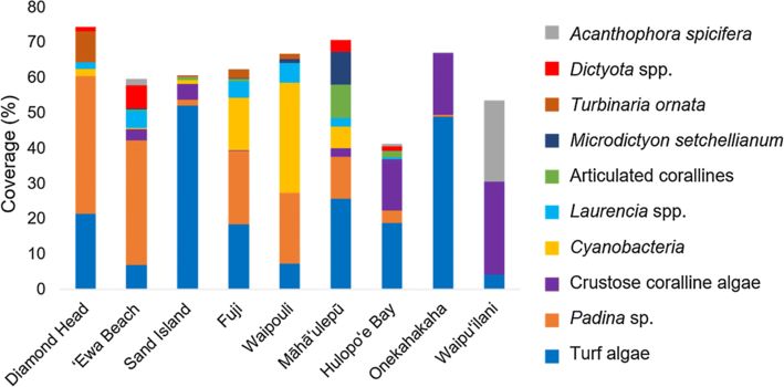
averaged over all sites. Figure 2 shows the ten most abundant taxa, which were
present with higher than 5% cover at one or more sites. Among the ten most
abundant species was A. spicifera, an invasive macroalgae, recorded at five out of
the nine sites.
Fig. 2
Most abundant algal taxa across all sites. The ten taxa shown were recorded with >
5% cover at one or more sites used in the spatial analyses
https://eproofing.springer.com/journals_v2/printpage.php?token=8XIaAQoaQKC3tSdSvo7fzd3RXl4zJ-n27DTuH60PPe4 12/346/22/2020 e.Proofing
Benthic community composition differed among sites, islands, and substrate types,
as shown by the PERMANOVA results (Table 3). Community composition did not
differ significantly by wind/wave exposure type. It is important to note that the
factors site and island, followed by substrate type, appear to be driving the variation
in assemblages (Table 3 and Fig. 3). This is evident in the high R-squared values
for site and island and can be visually observed in the nMDS (Fig. 3).
Table 3
Single factor PERMANOVA results for spatial analysis of nine sites
Factor df SS MS Pseudo F R2 P
Site 8 3.234 0.404 5.249 0.750 0.0001*
Substrate 1 0.553 5.553 3.016 0.188 0.0216*
Island 1 0.336 0.336 2.400 0.138 0.0251*
Wind/wave exposure 1 0.264 0.264 1.533 0.075 0.1474
All PERMANOVAs were run with 9999 unique permutations; asterisks indicate P values
< 0.05
Fig. 3
nMDS of sites in the spatial analysis. The gray polygons connect sites located on the
same island; the gray polygon on the right represents O‘ahu and gray polygon on the
https://eproofing.springer.com/journals_v2/printpage.php?token=8XIaAQoaQKC3tSdSvo7fzd3RXl4zJ-n27DTuH60PPe4 13/346/22/2020 e.Proofing
left represents Kaua‘i. The shape of the points correspond to substrate type and color
refers to wind/wave exposure type. Site codes are Diamond Head (DH), ‘Ewa Beach
(EB), Sand Island (SI), Fuji (FJ), Māhā‘ulepū (MA), Waipouli (WP), Hulopo‘e Bay
(HB), Onekahakaha (ON), and Waipu‘ilani (WL)
AQ3
The indicator species test pointed to specific taxa characterizing each subgroup of
site, substrate type, and island (Table 4). Most indicator taxa were macroalgae; this
reflects their greater coverage at sites relative to invertebrate taxa. Specific
indicator taxa were identified for five out of nine sites and for the island of Kaua‘i.
Each substrate type had two indicator taxa.
Table 4
Indicator species for factors analyzed in the spatial data
https://eproofing.springer.com/journals_v2/printpage.php?token=8XIaAQoaQKC3tSdSvo7fzd3RXl4zJ-n27DTuH60PPe4 14/346/22/2020 e.Proofing
Factor: level Indicator species Stat P
Site
Diamond Head Turbinaria ornata 0.889 0.040*
‘Ewa Beach Avrainvillea amadelpha (Montagne) 0.861 0.021*
A.Gepp & E.S.Gepp
Microdictyon setchellianum M. 0.990 0.028*
Howe
Māhā‘ulepū Articulated corallines 0.866 0.032*
Colpomenia sinuosa (Mertens ex 0.888 0.047*
Roth) Derbès & Solier
Onekahakaha Coral 0.979 0.017*
Acanthophora spicifera 0.965 0.007**
Waipu‘ilani
Gelidiales 0.744 0.049*
Fuji + Waipouli Cyanobacteria 0.885 0.032*
Onekahakaha + Sand Island Turf algae 0.879 0.008**
Hulopo‘e Bay + Onekahakaha CCA 0.788 0.049*
+ Waipu‘ilani
Diamond Head + ‘Ewa Beach Padina spp. 0.848 0.007**
+ Fuji + Waipouli
Island
Cyanobacteria 0.653 0.015*
Kaua‘i Microdictyon setchellianum 0.558 0.015*
Lyngbya majuscula Harvey ex 0.531 0.035*
Gomont
Substrate type
Turf algae 0.782 0.010*
Basalt
Echinometra spp. 0.587 0.025*
Cyanobacteria 0.647 0.015*
Limestone
Gelidiales 0.463 0.045*
Factors include site, island, substrate type, and wind/wave exposure type. For each
factor, only the levels for which one or more significant indicator species were identified
are listed. Asterisks indicate P values < 0.05 (*) and < 0.01 (**)
https://eproofing.springer.com/journals_v2/printpage.php?token=8XIaAQoaQKC3tSdSvo7fzd3RXl4zJ-n27DTuH60PPe4 15/346/22/2020 e.Proofing
Although invertebrate taxa were seldom identified as indicator species, there were
some similarities in invertebrate abundance and composition among sites. Sand
Island, Onekahakaha, and Hulopo‘e Bay had high abundances of invertebrates and
cluster together on the nMDS (Figs. 3, 4). The most abundant invertebrate species
at Sand Island were urchins (Echinometra spp.) and vermetids. The coral species
Pocillopora damicornis Linnaeus and P. lobata made up about 2% of the benthic
cover at Onekahakaha. Nerites, urchins, and sea cucumbers (Holothuria spp.) were
most abundant at Hulopo‘e Bay (Fig. 4).
Fig. 4
Most abundant invertebrate taxa across all sites. The five taxa shown were recorded
with > 1% cover at one or more sites used in the spatial analyses
Decadal variation in community assemblages
The decadal dataset with grouped taxa showed high overall richness of benthic
organisms, with a total of 55 algal taxa and 37 invertebrate taxa. Both year nested
by site and decade nested by site were significant in the PERMANOVAs (single
factor PERMANOVAs, Table 5). A visual assessment of community composition at
Sand Island and Diamond Head suggested that communities vary more between
https://eproofing.springer.com/journals_v2/printpage.php?token=8XIaAQoaQKC3tSdSvo7fzd3RXl4zJ-n27DTuH60PPe4 16/346/22/2020 e.Proofing
decades than between years in the same decade, although the other three sites did
not follow this pattern (Supp. Figure 1).
Table 5
Single factor PERMANOVA results for temporal analysis
Factor df SS MS Pseudo F R2 P
Decade (site) 9 2.839 0.315 3.686 0.787 0.0001 *
Year (site) 5 2.256 0.451 4.332 0.625 0.0001 *
Each PERMANOVA was run with 9999t unique permutations; asterisks indicate P values
< 0.05
In addition, we identified several taxa that changed abundance significantly
between decades, either at one individual site or across the five sites. From
averaged data of all sites (Table 6), turf algal forms were highly abundant in 2006
and 2007 (μ06–07 ≈ 12%) and more than doubled by 2016 and 2017 (μ16–17 ≈ 25%).
This change was mainly driven by the high coverage of turf algae at Sand Island.
The same pattern was observed for CCA (μ06–07 ≈ 2% to μ16–17 ≈ 9%) (Fig. 5).
Padina spp. was highly abundant in both decades (μ06–07 ≈ 10%, μ16–17 ≈ 13%).
Among invertebrates, vermetids were abundant in both decades, averaging > 1%.
Table 6
Wilcoxon test results for taxa that changed abundance significantly between 2006–2007 and
2016–2017
Taxon Site μ06–07 (± SD) μ16–17 (± SD) P
CCA All sites 1.74 (± 3.44) 9.40 (± 14.6) 0.0437 *
Turbinaria ornata All sites 0.0433 (± 0.149) 1.48 (± 2.97) 0.0491 *
Diamond 0.133 (± 0.243) 5.30 (± 4.18) 0.0437 *
Head
Barber’s Point 0 (± 0) 0.956 (± 0.0437 *
0.482)
Hypnea spp. All sites 0.0235 (± 0.443 (± 0.0138 *
0.0806) 0.649)
Average abundances (μ) were calculated using surveys as replicates. The number of
surveys conducted per site per decade ranged from 2 to 13, and P values are adjusted for
false discovery rate. Classification “all sites” refers to a Wilcoxon test done on surveys
from all five sites for 2006–2007 and 2016–2017. Asterisks indicate P values < 0.05
https://eproofing.springer.com/journals_v2/printpage.php?token=8XIaAQoaQKC3tSdSvo7fzd3RXl4zJ-n27DTuH60PPe4 17/346/22/2020 e.Proofing
Taxon Site μ06–07 (± SD) μ16–17 (± SD) P
Turf algae Sand Island 10.3 (± 7.34) 50.3 (± 5.68) 0.0437 *
Sargassum spp. Diamond 9.31 (± 4.18) 1.93 (± 1.40) 0.0491 *
Head
Acanthophora Sand Island 0.816 (± 0.800) 0 (± 0) 0.0497 *
spicifera
Barber’s Point 4.11 (± 0.997) 1.68 (± 1.01) 0.0593
Average abundances (μ) were calculated using surveys as replicates. The number of
surveys conducted per site per decade ranged from 2 to 13, and P values are adjusted for
false discovery rate. Classification “all sites” refers to a Wilcoxon test done on surveys
from all five sites for 2006–2007 and 2016–2017. Asterisks indicate P values < 0.05
Fig. 5
Mean percent cover of CCA and Turbinaria ornata by site and year. Mean abundance
of CCA (a) and T. ornata (b) surveyed at Diamond Head (DH), Barber’s Point (BP),
Sand Island (SI), Waipu‘ilani (WL), and Wai‘ōpae (WO) during 4 years spanning a
decade (except for WO, which was not surveyed in 2006). The gray bars show the
mean abundance of T. ornata and CCA averaged first by month, then by year within
site, then averaged across the five sites. Symbols show the mean abundances at each
site for that year
https://eproofing.springer.com/journals_v2/printpage.php?token=8XIaAQoaQKC3tSdSvo7fzd3RXl4zJ-n27DTuH60PPe4 18/346/22/2020 e.Proofing
Three algal taxa (CCA, T. ornata, and Hypnea spp.) changed abundance
significantly between 2006–2007 and 2016–2017 across the five sites. Four taxa
changed abundance significantly at one or more individual sites (Table 6). In each
case, the change in abundance in these taxa between decades was greater than
within month variation, calculated by looking at ranges of relative abundance for
data collected within the same month in the same year and by different observers
(Supp Table 4). Most decadal changes appear to be site specific, which is in
agreement with previous work (Cox et al., 2013) and the spatial analyses.
T.urbinaria ornata increased from 2006–2007 to 2016–2017 when all sites were
pooled together, as well as at Diamond Head and Barber’s Point when site
https://eproofing.springer.com/journals_v2/printpage.php?token=8XIaAQoaQKC3tSdSvo7fzd3RXl4zJ-n27DTuH60PPe4 19/346/22/2020 e.Proofing
abundances were examined separately. CCA increased in abundance from 2006–
2007 to 2016–2017 across all sites (Fig. 5). The abundance of Hypnea spp. also
changed significantly between 2006–2007 and 2016–2017, but its mean cover was
< 1% in every year.
SIMPER analysis identified the taxa that contributed to the observed differences in
composition and abundance of the benthic communities between 2006–2007 and
2016–2017 (Table 7). The increase in turf algae was responsible for 26% of the
decadal difference between the assemblages, followed by increased abundances of
Padina spp. (18%), and CCA (15%). The invasive algal species A. spicifera was
responsible for 5% of the difference in assemblages between the two decades.
Vermetids, the only invertebrates that were identified as contributing to community
differences among decades, were responsible for 2% of the difference in
assemblages. The top ten species listed in Table 7 are cumulatively responsible for
over 85% of the differences in assemblages between 2006–2007 and 2016–2017.
Table 7
SIMPER results for temporal analysis (using year averages)
Taxa Average SD Ratio μ06–07 μ16–17 Cum. sum
Turf algae 0.1883 0.2006 0.9386 12.06 25.08 0.2620
Padina spp. 0.1326 0.1145 1.1580 10.44 12.78 0.4465
CCA 0.1046 0.1622 0.6452 2.402 11.17 0.5920
Brown crust 0.0506 0.1182 0.4279 0.4309 6.730 0.6624
Acanthophora spicifera 0.0346 0.06646 0.5204 1.026 3.168 0.7105
Laurencia spp. 0.0315 0.03593 0.8772 3.307 1.810 0.7543
Sargassum spp. 0.0297 0.02948 1.0084 3.352 1.747 0.7957
Vermetidae 0.0151 0.01489 1.0155 1.110 1.606 0.8167
Cyanobacteria 0.0150 0.01237 1.2152 8.192 1.805 0.8376
Turbinaria ornata 0.0111 0.02209 0.5043 0.043 1.476 0.8531
Taxa are ordered by contribution to between-group dissimilarity (Average). SD is the
standard deviation of each taxon’s contribution, ratio is the average to SD ratio, μ is the
average relative abundance for 2006–2007 and 2016–2017, respectively, and Cum. sum
is the cumulative sum of the taxa contributions to between-group similarity
Discussion
https://eproofing.springer.com/journals_v2/printpage.php?token=8XIaAQoaQKC3tSdSvo7fzd3RXl4zJ-n27DTuH60PPe4 20/346/22/2020 e.Proofing
Spatial analysis
Spatially broad studies such as this are important for understanding the scales of
variation in intertidal communities. In contrast, many intertidal studies have
focused on a few species and their interactions (e.g., Menge et al., 1994 or have
limited temporal coverage (e.g., Zabin et al., 2013. This study of tropical rocky
intertidal communities increased spatial coverage compared to previous studies and
reduced yearly and monthly bias. We found that benthic community composition in
Hawai‘i’s intertidal is highly variable and differs significantly by site and island, in
agreement with Cox et al. (2013. We identified substrate type as an additional,
significant factor influencing intertidal communities.
One major result of our study is that Hawai‘i exhibits distinct benthic intertidal
communities at the scale of sites separated by 10 s to 100 s of kms, similar to
patterns reported for other intertidal systems (Fraschetti et al., 2005; Valdivia et al.,
2011; Watson & Barnes, 2004. Our results extend this finding in Hawai‘i’s tropical
setting. The physical factors driving community site-specificity remain to be
determined, although temperature (Blanchette et al., 2009, land-use (Groffman et
al., 2004, nutrient availability (Larned, 1998, and groundwater (McCook, 1999;
Lyons et al., 2014 are likely candidates. For example, local sea surface temperature
was highly correlated with community structure in a study of 22 intertidal sites in
the Channel Islands of California (Blanchette et al., 2009. Satellite data on sea
surface temperature is readily available and could be combined with this citizen
science data set to test additional hypotheses about intertidal community variation.
The observed variation across multiple spatial scales likely results from the
biological processes and physical factors operating at these different scales
(Martins et al., 2008. For example, dispersal may drive community assembly at
both island and exposure type (i.e., island region scales (Palmer et al., 1996. In
contrast, substrate is often site-specific and limestone and basalt differ in color and
therefore retain heat differently, potentially affecting species vulnerable to warmer
temperatures (Cox et al., 2011. Substrate can also influence local topography,
which can, in turn, create physical refugia and structures that affect organisms’
ability to persist in these areas (Green et al., 2012. In agreement with our study,
substrate type was a significant indicator of algal and invertebrate community
composition in Australian intertidal reefs (Bessey et al., 2019. Climate change will
operate in different ways at all of these spatial scales; for example, thermal stress
on intertidal organisms is not linearly related to latitude and is predicted to show
complex spatial and temporal patterns of variation under climate change (Helmuth et
al., 2006). Furthermore, the periodicity of high temperature
https://eproofing.springer.com/journals_v2/printpage.php?token=8XIaAQoaQKC3tSdSvo7fzd3RXl4zJ-n27DTuH60PPe4 21/346/22/2020 e.Proofing
events has been linked to the spread of exotic species (Stachowicz et al., 2002),
with potential to greatly alter intertidal community structure.
AQ4
Climatological, hydrodynamic, and oceanographic factors may affect the dispersal
of organisms and their relative success in areas with different wind/wave exposure
types (Bustamante & Branch, 1996; Morgan et al., 2009; Castorani et al., 2015).
Despite broad climatological differences between windward and leeward sides of
islands (e.g., rainfall, currents, wave action, wind), our results suggest that
wind/wave exposure does not correspond with community composition in Hawaiian
intertidal sites. It is likely that broad categories such as windward vs. leeward are
too coarse and that benthic communities are more strongly impacted by local
factors, such as substrate, or that the effects of wind and wave exposure on
intertidal communities occur at smaller spatial scales.
Intertidal community composition differed between O‘ahu and Kaua‘i. This result
agrees with the finding of Cox et al. (2013) that Hawaiian intertidal communities
differ by island, although our spatial analysis is limited by the fact that only two
islands, O‘ahu and Kaua‘i, were included in the analysis. Lāna‘i, Hawai‘i, and Maui
were each represented by a single site, so differences among islands would have
been conflated with site differences. To characterize the intertidal communities of
each island and region more generally, future studies should aim to sample
additional sites on Lāna‘i, Hawai‘i, and Maui within the same time period.
Finally, the importance of local factors in shaping benthic intertidal communities
has implications for watershed management at the island level. As the Hawaiian
archipelago contains numerous endemic species, including algae such as Laurencia
mcdermidiae and Wrangelia elegantissima (Tsuda, 2014), it is important that state-
level management empower local and regional authorities to protect these natural
resources.
Temporal analysis
This study leveraged a long-term validated citizen science dataset to detect
significant yearly and decadal shifts in Hawaiian intertidal communities, with
notable significant changes in abundance of individual species over a decade. Most
species-specific decadal changes appear to be site-specific, except for CCA and T.
ornata, which exhibited significant changes in abundance across five sites. Our
finding that most long-term changes are site specific agrees with our spatial
analysis (Table 3) and Cox et al. (2013); this finding suggests that community
https://eproofing.springer.com/journals_v2/printpage.php?token=8XIaAQoaQKC3tSdSvo7fzd3RXl4zJ-n27DTuH60PPe4 22/346/22/2020 e.Proofing
changes are strongly driven by local factors. It is also possible that the effects of
global scale changes (e.g., ocean warming) are mediated by local factors, resulting
in different changes across different communities (Gurney et al., 2013).
CCA increased significantly across the five sites, with the largest increase
occurring at Waipu‘ilani. Studies focused on tropical islands have shown that
following warm water events there can be a drop in fleshy macroalgae abundance
and an increase in CCA (Cox et al., 2017). The abundance of turf algae also
increased across all sites and increased fivefold at Sand Island. Turf algae can be
opportunistic species with high turnover rates, and they are highly stress tolerant
compared to fleshy macrophytes (Airold, 1998). Filbee-Dexter & Wernberg (2018)
showed that regime shifts from kelp forests to turf-dominated systems are
widespread and mediated by biotic and abiotic (warming and eutrophication)
processes. Both CCA and turf are understory algae and tend be resilient to physical
disturbance (Micheli et al., 2016). It is possible that once fleshy perennial species
are lost, they take longer to recover, leaving CCA and turf algae uncovered for long
periods of time. In addition, Vermeij et al. (2011) found a negative relationship
between CCA and macroalgal abundance on Hawaiian reefs. Our SIMPER analysis
identified Laurencia spp. and Sargassum spp., both of which declined in
abundance, as two of the top ten contributors to dissimilarity in intertidal
communities between decades. Thus, a decline in fleshy species such as these may
be related to the observed decadal increase in CCA and turf algae. According to the
National Marine Fisheries Service (NOAA Fisheries), mean sea surface
temperatures in Hawai‘i have increased over the past five decades (Coles et al.,
2018). It is possible that with an increased frequency of high temperature events,
disturbances affecting fleshy macroalgae, as well as shifts in nutrient regimes
caused by changing land cover, CCA and turf algae outcompeted macrophytes for
space.
Turbinaria ornata increased in abundance across all sites; however, this trend was
driven by large increases at Diamond Head and Barber’s Point, both located on the
south shore of O‘ahu. Turbinaria ornata is a fleshy and rigid macroalga that is also
very resistant to high wave action and is usually found in wave exposed areas
(Stiger and Payri 1999). In addition, T. ornata contains chemical deterrents in its
thallus (Stiger et al., 2004) and becomes less susceptible to herbivory as it grows,
with large stands of T. ornata experiencing low herbivory (Bittick et al., 2010;
Davis, 2018). T. ornata’s resistance to herbivory combined with the depletion of
herbivorous fish around O‘ahu (Helyer & Samhouri, 2017), may have contributed
to its general increase at Barber’s Point and Diamond Head. In French Polynesia, T.
https://eproofing.springer.com/journals_v2/printpage.php?token=8XIaAQoaQKC3tSdSvo7fzd3RXl4zJ-n27DTuH60PPe4 23/346/22/2020 e.Proofing
ornata has been an established invader of reefs for the past three decades (Done,
1992; Payri & Stiger, 2001), suggesting that its presence and abundance on
Hawaiian coastlines should be monitored. Among the multiple stressors currently
impacting Hawaiian coastal marine communities are rising sea level and increased
frequency of extreme tide events (Firing, 2004) and storms (Norton et al., 2011) as
well as pulsed heating events resulting in coral bleaching (Jokiel & Brown, 2004).
All of these stressors may have caused physical disturbances of fleshy macroalgae,
creating space for hardier species, such as T. ornata, to continue to establish
themselves.
Future work
Long-term monitoring studies are important in providing baseline data and to
ground truth changes in community structure. Broad spatial and temporal studies
can help us understand whether changes in benthic community patterns are cyclical,
or due to local disturbances or climate change (Southward et al., 2005). Large scale
disturbances can completely reset community structure, providing opportunities to
study the assembly of new communities and succession dynamics; at Wai‘ōpae, one
of our sites on Hawai‘i island, the volcanic eruption of Kīlauea covered the entire
survey location, along with over 6 km of shoreline, with lava. The baseline
community data collected at Wai‘ōpae will allow future studies to compare the new
community that develops with the community that was effaced. This study site
could provide a rare opportunity to study primary succession at a spatial scale of
kilometers, with the scale of disturbance being an important factor affecting
alternative community states (Petraitis & Latham, 1999). Monitoring this site could
elucidate the success of different types of recruits and their persistence over time.
The ability to correlate changes in Hawai‘i’s intertidal benthic communities with
environmental variables is limited by the lack of coverage of environmental data
and complexities associated with the many biological and physicochemical factors
potentially affecting these systems (Helmuth et al., 2006; Cox & Smith, 2011).
Future studies could monitor site-specific water and air temperatures as well as
nutrient levels, particularly during dry periods and after rain events, to examine
how community structure correlates with these abiotic factors. In addition,
understanding the mechanisms driving temporal changes in species abundances is
necessary in order to predict future changes, including the impacts of nutrient
regimes, climate shifts, and coastal development on tropical intertidal systems. For
example, experimental manipulation of fleshy macroalgal cover (e.g., by clearing
these species from experimental plots in the intertidal) could be used to test the
https://eproofing.springer.com/journals_v2/printpage.php?token=8XIaAQoaQKC3tSdSvo7fzd3RXl4zJ-n27DTuH60PPe4 24/346/22/2020 e.Proofing
hypothesis that disturbance and decline of fleshy macroalgae have allowed CCA
and turf algae to increase in Hawai‘i’s intertidal, as documented across multiple
sites in our study. Lab experiments could be used to investigate the effect of
specific abiotic disturbances, such as pulsed heating events, on the competitive
abilities of fleshy macroalgae compared to CCA and turf algae.
In conclusion, Hawaiian rocky intertidal sites are species rich and differ at local,
regional, and island scales. Significant decadal changes in the abundance of
intertidal algae, both site-specific and across sites, point to changes in the drivers of
community structure at multiple spatial and temporal scales. Future studies with
broad temporal and spatial coverage, facilitated by citizen scientists, should
continue to monitor these community changes, as well as test mechanisms
potentially driving them at relevant spatial scales.
Publisher's Note
Springer Nature remains neutral with regard to jurisdictional claims in published
maps and institutional affiliations.
Acknowledgements
We would like to thank our collaborators C. Nelson, A. Faucci, H. Spalding for
their advice and support throughout the study as well as the teachers, students, and
other volunteers involved in the Our Project In Hawai‘i’s Intertidal (OPIHI)
program. This paper is funded by a grant from the National Oceanic and
Atmospheric Administration, Bay Watershed Education and Training Project, under
award No. NA18NOS4730196 from NOAA Office of Education, Department of
Commerce. The views expressed herein are those of the author(s) and do not
necessarily reflect the views of NOAA or any of its subagencies. This paper is also
funded by a grant/cooperative agreement from the National Oceanic and
Atmospheric Administration, Project NA18OAR4170076, which is sponsored by
the University of Hawai‘i Sea Grant College Program, SOEST, under Institutional
Grant No. NA18OAR4170076 from NOAA Office of Sea Grant, Department of
Commerce. The views expressed herein are those of the authors and do not
necessarily reflect the views of NOAA or any of its subagencies.
AQ5
Electronic supplementary material
https://eproofing.springer.com/journals_v2/printpage.php?token=8XIaAQoaQKC3tSdSvo7fzd3RXl4zJ-n27DTuH60PPe4 25/346/22/2020 e.Proofing
Below is the link to the electronic supplementary material.
Supplementary material 1 (DOCX 92 kb)
References
Airold, L., 1998. Roles of disturbance, sediment stress, and substratum retention
on spatial dominance in algal turf. Ecology 79: 2759–2770.
Barry, J. P., C. H. Baxter, R. D. Sagarin & S. E. Gilman, 1995. Climate-related,
long-term faunal changes in a California rocky intertidal community. Science
267: 672–675.
Baumgartner, E. & C. Zabin, 2008. A case study of project-based instruction in
the ninth grade: a semester-long study of intertidal biodiversity. Environmental
Education Research 14: 97–114.
Bessey, C., M. J. Rule, M. Dasey, A. Brearley, J. M. Huisman, S. K. Wilson &
A. J. Kendrick, 2019. Geology is a significant indicator of algae cover and
invertebrate species composition on intertidal reefs of Ngari Capes Marine Park,
south-western Australia. Marine & Freshwater Research 70: 270–279.
Bird, C. E., E. C. Franklin, C. M. Smith & R. J. Toonen, 2013. Between tide and
wave marks: a unifying model of physical zonation on littoral shores. PeerJ 1:
e154.
Bittick, S., N. D. Bilotti, H. A. Peterson & H. L. Stewart, 2010. Turbinaria
ornata as an herbivory refuge for associate algae. Marine Biology 157: 317–323.
Blanchette, C. A., P. T. Raimondi & B. R. Broitman, 2009. Spatial patterns of
intertidal community structure across the California Channel Islands and links to
ocean temperature. In Proceedings of the 7th California Islands Symposium.
Arcata, CA: Institute for Wildlife Studies: 161–173.
Bustamante, R. H. & G. M. Branch, 1996. Large scale patterns and trophic
structure of Southern African rocky shores: the roles of geographic variation and
wave exposure. Journal of Biogeography 23: 339–351.
https://eproofing.springer.com/journals_v2/printpage.php?token=8XIaAQoaQKC3tSdSvo7fzd3RXl4zJ-n27DTuH60PPe4 26/346/22/2020 e.Proofing
Cáceres, M. D. & P. Legendre, 2009. Associations between species and groups
of sites: indices and statistical inference. Ecology 90: 3566–3574.
Campbell, M. L., L. D. Heppenstall, R. Hendry, R. Martin, S. Sorensen, A. N.
Rubenstein & C. L. Hewitt, 2017. Niche partitioning of intertidal seagrasses:
evidence of the influence of substrate temperature. New Phytologist 217(4):
1449–1462.
Castorani, M. C. N., D. C. Reed, F. Alberto, T. W. Bell, R. D. Simons, K. C.
Cavanaugh, D. A. Siegel & P. T. Raimondi, 2015. Connectivity structures local
population dynamics: a long-term empirical test in a large metapopulation
system. Ecology 96: 3141–3152.
Chapperon, C. & L. Seuront, 2011. Space-time variability in environmental
thermal properties and snail thermoregulatory behaviour. Functional Ecology 25:
1040–1050.
Coles, S. L., K. D. Bahr, K. S. Rodgers, S. L. May, A. E. McGowan, A. Tsang, J.
Bumgarner & J. H. Han, 2018. Evidence of acclimatization or adaptation in
Hawaiian corals to higher ocean temperatures. PeerJ 6: e5347.
Connell, J. H., 1961. The influence of interspecific competition and other factors
on the distribution of the barnacle Chthamalus stellatus. Ecology 42: 710–723.
Cox, T. E. & M. S. Foster, 2013. The effects of storm-drains with periodic flows
on intertidal algal assemblages in ‘Ewa Beach (O‘ahu), Hawai‘i. Marine
Pollution Bulletin 70: 162–170.
Cox, T. & C. Smith, 2011. Thermal ecology on an exposed algal reef: infrared
imagery a rapid tool to survey temperature at local spatial scales. Coral Reefs.
https://doi.org/10.1007/s00338-011-0799-2.
Cox, T. E., E. Baumgartner, J. Philippoff & K. S. Boyle, 2011. Spatial and
vertical patterns in the tidepool fish assemblage on the island of O`ahu.
Environmental Biology of Fishes 90: 329–342.
Cox, T. E., J. Philippoff, E. Baumgartner & C. M. Smith, 2012. Expert
variability provides perspective on the strengths and weaknesses of citizen-
driven intertidal monitoring program. Ecological Applications 22: 1201–1212.
https://eproofing.springer.com/journals_v2/printpage.php?token=8XIaAQoaQKC3tSdSvo7fzd3RXl4zJ-n27DTuH60PPe4 27/34You can also read