Variscan structures and their control on latest to post-Variscan basin architecture: insights from the westernmost Bohemian Massif and ...
←
→
Page content transcription
If your browser does not render page correctly, please read the page content below
Solid Earth, 13, 393–416, 2022
https://doi.org/10.5194/se-13-393-2022
© Author(s) 2022. This work is distributed under
the Creative Commons Attribution 4.0 License.

Variscan structures and their control on latest to
post-Variscan basin architecture: insights from the
westernmost Bohemian Massif and southeastern Germany
Hamed Fazlikhani, Wolfgang Bauer, and Harald Stollhofen
GeoZentrum Nordbayern, Friedrich-Alexander-Universität (FAU) Erlangen-Nürnberg, Schlossgarten 5,
91054 Erlangen, Germany

Correspondence: Hamed Fazlikhani (hamed.fazli.khani@fau.de)

Received: 26 July 2021 – Discussion started: 2 August 2021
Revised: 21 December 2021 – Accepted: 16 January 2022 – Published: 24 February 2022

Abstract. The Bohemian Massif exposes structures and             1   Introduction
metamorphic rocks remnant from the Variscan orogeny in
central Europe and is bordered by the Franconian Fault           Variscan orogenic units and structures in central and west-
System (FFS) to the west. Across the FFS, Variscan units         ern Europe are extensively studied from disconnected ex-
and structures are buried by Permo-Mesozoic sedimentary          posed terranes in the Bohemian Massif, the Rhenohercynian
rocks. We integrate existing DEKORP 2D seismic reflection,       Massif, the Black Forest and Vosges, the Armorican Massif,
well, and surface geological data with the newly acquired        and the Central Iberian Zone (Franke, 2000). Between ex-
FRANKEN 2D seismic survey to investigate the possible            posed Variscan units, younger sedimentary rocks obscure di-
westward continuation of Variscan tectonostratigraphic units     rect observation of possible lateral extension and architecture
and structures and their influence on latest to post-Variscan    of Variscan tectonostratigraphy and structures. In southern
basin development. Subsurface Permo-Mesozoic stratigra-          Germany, for instance, Variscan units of the Bohemian Mas-
phy is obtained from available wells and tied to seismic         sif are correlated with exposed Variscan units in the Black
reflection profiles using a synthetic seismogram calculated      Forest and Vosges, separated by ca. 300 km, causing un-
from density and velocity logs. Below the sedimentary cover,     certainties in the lateral continuation and architecture of the
three main basement units are identified using seismic facies    Variscan tectonometamorphic Saxothuringian and Moldanu-
descriptions that are compared with seismic reflection char-     bian zones that were originally defined by Kossmat (1927).
acteristics of exposed Variscan units east of the FFS. Our       Although a few wells provide local but valuable information
results show upper Paleozoic low-grade metasedimentary           about basement rock types, only a few regional 2D seismic
rocks and possible Variscan nappes bounded and transported       profiles (DEKORP 84-2s and 90-3B/MVE and KTB84) im-
by Variscan shear zones ca. 65 km west of the FFS. Basement      age the Variscan units and structures below the sedimentary
seismic facies in the footwall of the Variscan shear zones       cover between the Bohemian Massif and Black Forest expo-
are interpreted as Cadomian basement and overlaying Pale-        sures (Franke et al., 2017; Behr and Heinrichs, 1987; Wever
ozoic sequences. We show that the location of normal fault-      et al., 1990; Edel and Weber, 1995; Meissner et al., 1987;
bounded latest to post-Variscan late Carboniferous–Permian       Lüschen et al., 1987).
basins are controlled by the geometry of underlying Variscan        The recently acquired FRANKEN 2D seismic survey cov-
shear zones. Some of these late Carboniferous–Permian nor-       ers the Carboniferous–Permian Kraichgau and Naab basins
mal faults reactivated as steep reverse faults during the re-    (Paul and Schröder, 2012; Sittig and Nitsch, 2012) and
gional Upper Cretaceous inversion. Our results also highlight    the overlying late Permian to Triassic Franconian Basin
that reverse reactivation of normal faults gradually decreases   (Freudenberger and Schwerd, 1996) in the western vicin-
west of the FFS.                                                 ity of the Bohemian Massif in SE Germany (Fig. 1). The
                                                                 FRANKEN survey is tied to the DEKORP 3/MVE-90 pro-

Published by Copernicus Publications on behalf of the European Geosciences Union.
394                        H. Fazlikhani et al.: Variscan structures of the westernmost Bohemian Massif and SE Germany

file creating a grid of regional seismic reflection profiles      upper crust and a ca. 45◦ rotation in the principal subhor-
imaging exposed and buried Saxothuringian units and struc-        izontal compression direction (to NNW–SSE) after 340 Ma
tures of the Variscan orogeny across the Franconian Fault         (Kroner and Goerz, 2010; Schönig et al., 2020; Hallas et al.,
System (FFS, Fig. 1). In this study we investigate the po-        2021; Stephan et al., 2016). The D2 deformation phase is
tential westward extension of Variscan tectonic units and         manifested by dextral transpression of D1 structures and duc-
structures and construct a first-order relationship between       tile deformation, with a generally top-to-the-northwest trans-
Variscan and post-Variscan structures and basin develop-          port direction (Kroner et al., 2007; Franke and Stein, 2000;
ment. Four new seismic profiles of the FRANKEN survey are         Kroner and Goerz, 2010; Franke, 1989). A third deformation
interpreted utilizing subsurface and surface geological data      phase (D3) records latest Variscan tectonics at ∼ 320 Ma and
and are tied to the existing DEKORP-3/MVE-90 profile. Un-         is represented by the folding of synorogenic deposits dur-
derneath the Permo-Mesozoic sedimentary cover, three main         ing general NW–SE to NNW–SSE shortening (Hahn et al.,
basement seismic facies (BSF1-3) are identified based on lat-     2010). The latest stages of D3 and the early post-Variscan
eral and vertical changes in reflection amplitude and connec-     are dominated by a wrench tectonic phase and the collapse
tivity. Comparing seismic reflection patterns observed in ex-     of thickened crust, resulting in the development of dextral
posed Variscan rocks of the Bohemian Massif with reflection       strike-slip faults initiating fault-bounded graben and half-
patterns along the FRANKEN seismic profiles, we show a            graben basins in central Europe, including the study area
W–SW continuation of Variscan shear zones and associated          in SE Germany (Schröder, 1987; Arthaud and Matte, 1977;
Variscan allochthons. The control of Variscan shear zone ge-      Krohe, 1996; Stephan et al., 2016; Ziegler, 1990; Eberts
ometries in strain localization influencing the latest to post-   et al., 2021). Detailed and comprehensive overviews of the
Variscan basin architecture and brittle fault interactions is     geodynamic and tectonostratigraphic evolution of the mid-
discussed.                                                        European Variscides have been presented by Linnemann and
                                                                  Romer (2010) and Franke et al. (2000).
                                                                     During the earliest post-Variscan development at <
2     Geological setting                                          305 Ma, widespread intermontane late Carboniferous–
                                                                  Permian graben and half-graben basins, such as the NE–
2.1    Variscan geodynamics and tectonic framework                SW-trending Saar-Nahe (Henk, 1993; Stollhofen, 1998; Boy
                                                                  et al., 2012), Saale (Ehling and Gebhardt, 2012), Kraich-
The Bohemian Massif comprises remnants of the Upper               gau, and Schramberg basins (Sittig and Nitsch, 2012), and
Paleozoic collision of Laurussia and Gondwana, known as           NW–SE-striking basins (e.g., the Naab and Thuringian For-
Variscan mountain belt, and of the pre-Variscan basement          est basins) are formed (Paul and Schröder, 2012; Lützner et
in central Europe (Franke, 2000; Kroner et al., 2007). The        al., 2012). The Rotliegend is characterized by widespread
Variscan orogeny has produced a wide range of metamor-            intra-basinal volcanism, and depositional areas became en-
phic units, ranging from high-pressure and high-temperature       larged across the internal parts of the Variscan Belt, e.g.,
metamorphic to low-grade metasedimentary rocks, abun-             in Switzerland (Matter et al., 1987), France (Chateauneuf
dant granitic intrusives, and crustal-scale shear zones and       and Farjanel, 1989; Cassinis et al., 1995; Engel et al., 1982;
faults. From north to south, the Variscides have tradi-           Laversanne, 1978; McCann et al., 2006), Germany (Henk,
tionally been subdivided into three main tectonometamor-          1993; Stollhofen, 1998; Boy et al., 2012; Lützner et al., 2012;
phic zones, the Rhenohercynian, Saxothuringian (includ-           Sittig and Nitsch, 2012; Paul and Schröder, 2012), and Iberia
ing the Mid-German Crystalline High), and Moldanubian             (e.g., Cassinis et al., 1995). In the study area, Carboniferous–
zones (Kossmat, 1927; Franke, 2000; Kroner et al., 2007).         Permian units are only exposed along the Franconian Fault
Saxothuringian and Moldanubian rocks are well exposed in          System (FFS, also known as Franconian Line) but have been
the Bohemian Massif but buried by Paleozoic and Mesozoic          drilled by several wells located farther west in the Kraichgau
sediments towards the west.                                       and Naab basins (Fig. 1, Table 1).
   The Saxothuringian Zone and its westward extension, as            In general, the top of Saxothuringian basement units be-
the main area of interest, underwent three main deforma-          neath the sedimentary cover shows a smooth topography
tional phases during the Variscan orogeny (Kroner et al.,         with a gentle southward rise, including lows along the SW–
2007 and references therein). A first deformation phase (D1)      NE axis of Würzburg–Rannungen and along the NW–SE
developed before 340 Ma and records pervasive deforma-            axis of Staffelstein–Obernsees, the latter being subparallel
tion during the subduction and collision, resulting in the de-    to the FFS (Gudden, 1981; Gudden and Schmid, 1985).
velopment of recumbent folds and thrusts with top-to-the-         Saxothuringian basement lithologies drilled by the Wolfers-
southwest transport direction as evidenced by kinematic in-       dorf and Mittelberg wells in the north, the Eltmann well
dicators (Kroner et al., 2007; Stettner, 1974; Franke et al.,     to the west, and the Obernsees well in the southeast of the
1992; Schwan, 1974). A second deformation phase (D2) de-          study area (Fig. 1 and Table 1) are Upper Devonian to lower
veloped due to the exhumation and juxtaposition of high-          Carboniferous low- to medium-grade metasedimentary rocks
pressure and ultra high-pressure metamorphic rocks in the

Solid Earth, 13, 393–416, 2022                                                         https://doi.org/10.5194/se-13-393-2022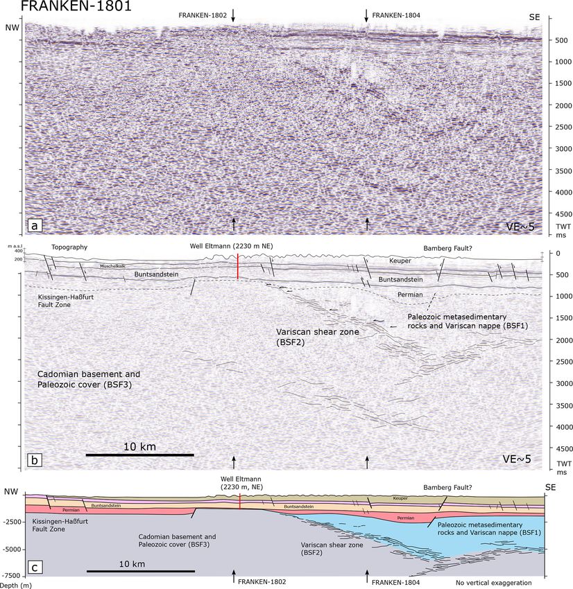
H. Fazlikhani et al.: Variscan structures of the westernmost Bohemian Massif and SE Germany                                       395

Figure 1. Location of the study area in the Saxothuringian Zone of the Variscan Orogen. The FRANKEN seismic survey is projected on
geological map of the study area in dark red, creating a grid of 2D seismic profiles with existing DEKORP profiles. The main faults are
shown as dark lines. The inset map shows exposed Variscan terranes in central Europe. Yellow circles show deep wells in the study area.
FRA stands for FRANKEN, MGCH stands for Mid-German Crystalline High, FFS stands for Franconian Fault System, MN stands for
Münchberg Nappe, Mür stands for Mürsbach, and STF stands for Staffelstein.

(Hahn et al., 2010; Stettner and Salger, 1985; Trusheim,              den, 1981), whereas the Mürsbach 6 and Staffelstein 1 wells
1964; Specht, 2018; Friedlein and Hahn, 2018).                        only penetrated ca. 20 and 43 m into the upper parts of the
                                                                      Rotliegend (Table 1). The Eltmann well, located in a basin
2.2   Latest to post-Variscan stratigraphic and                       marginal position, encountered only 3 m of Rotliegend (Ta-
      structural architecture                                         ble 1, Trusheim, 1964). Towards the SE of the study area,
                                                                      the Obernsees well encountered 18.3 m of Rotliegend overly-
Carboniferous–Permian units in the study area dominantly              ing metasedimentary basement rocks (Table 1, Helmkampf,
comprise clastic continental sediments deposited in fault-            2006; Ravidà et al., 2021). However, ca. 19 km NE of
bounded basins outcropping in the Schalkau, Stockheim, Ru-            the Obernsees well, the Lindau 1 well drilled 250.25 m of
gendorf, Wirsberg, and Weidenberg areas (Schröder, 1987).             Rotliegend strata without reaching their base (Fig. 1, Table 1;
Thicknesses are highly variable, ranging from about 100 to            Freudenberger et al., 2006). Compared to the Rotliegend,
> 700 m in the Kraichgau Basin and from about 100 up to               the Zechstein tends to be of more uniform thickness mainly
> 1400 m in the Naab Basin adjacent to the FFS (Gudden,               comprising of clay, sandstone, dolomites, and thin layers
1981; Paul and Schröder, 2012). In the Stockheim outcrop,             of anhydrite (Schuh, 1985). Drilled Zechstein thicknesses
the Wolfersdorf well is drilled into 726 m of Rotliegend,             are 117 m in the Eltmann well, 126 m in the Mürsbach 1
excluding an unknown amount of eroded section (Fig. 1                 well, 107 m in the Staffelstein well, and 104.9 m in the
and Table 1). In the center of the study area, 109 m of               Obernsees well (Table 1). Refraction seismic surveys in the
Rotliegend was encountered by the Mürsbach 1 well (Gud-               south of the study area (Nürnberg area) proved the existence

https://doi.org/10.5194/se-13-393-2022                                                              Solid Earth, 13, 393–416, 2022
396                       H. Fazlikhani et al.: Variscan structures of the westernmost Bohemian Massif and SE Germany

Table 1. Deep wells in the study area with formation tops used in seismic horizon interpretation of FRANKEN seism survey. See Fig. 1 for
well locations. TD stands for total depth.

  Well                  Quaternary   Jurassic   Keuper   Muschelkalk      Buntsandstein   Zechstein   Rotliegend   Basement   TD (m)
  Obernsees                      0       140       483         178.35           417.15       104.9         18.3        48.3      1390
  Mürsbach 01                   26         0       300            224              524         126          109           –      1309
  Mürsbach 03                    0         0     384.4          212.6              551          87            –           –      1235
  Mürsbach 04                    0         0     345.6          210.5            548.3        73.6            –           –      1178
  Mürsbach 05                 15.6         0     338.1          214.7              559        56.6            –           –      1184
  Mürsbach 06                    0         0     338.3          210.7            530.7       121.6         20.7           –      1222
  Staffelstein 1                 9       102     530.2          239.8            572.2       103.8           43           –      1600
  Staffelstein 2                 8       104       532            235              301           –            –           –      1180
  Eltmann                      9.4         0     178.6            235              510         114            3          94      1144
  Lindau                      0.25         0         0              0           182.05       98.05       250.25           –     530.6
  Laineck                      3.5         0     409.5            179              488          42            –           –      1122
  Haarbrücken                    6         0         0              0              199       109.5        185.4           –     499.9
  Mittelberg                     0         0         0              0            405.5        75.5         41.5       100.5       623
  Bad Rodach 1                   0         0       130            266              256           –            –           –       652
  Bad Rodach 2                   0         0     211.7          257.1            526.2          20            –           –      1015
  Bad Königshofen              3.5         0      56.5            251              640          76            –           –      1027
  Bad Colberg                   18         0     322.5          224.5            555.5         157        123.5           –      1401
  Wolfersdorf                   14         0         0              0                0           0          726        29.5     769.5
  (Stockheim outcrop)

of deep, fault-bounded grabens, whereas the Rotliegend top              exposed in the western and northwestern part of the study
is characterized by a peneplain beneath the Zechstein (Bader            area and in the fault block bounded by the Eisfeld–Kulmbach
and Bram, 2001; Buness and Bram, 2001). This suggests                   and Asslitz faults (Fig. 1). Jurassic units are preserved in the
a regional disconformity between Rotliegend and Zechstein               central and eastern parts of the study area but eroded to-
and supports the separation between the Carboniferous–                  wards the west and northwest (Fig. 1). Jurassic outcrops to
Permian (mainly Rotliegend) Kraichgau Basin and the post-               the east are fault-bounded and are limited to the footwall of
Rotliegend (mainly Mesozoic) Franconian Basin develop-                  the Eisfeld–Kulmbach, Asslitz, and Lichtenfels reverse faults
ment (Freudenberger et al., 2006; Paul, 2006).                          (Fig. 1). The Jurassic interval is 102 to 104 m thick in the
   Triassic stratigraphy is divided into Lower to lowermost             Staffelstein 1 and 2 wells in the north and 140 m thick in
Middle Triassic Buntsandstein, Middle Triassic Muschel-                 the Obernsees well in the SE (Table 1; Meyer, 1985; Gud-
kalk, and uppermost Middle to Upper Triassic Keuper groups              den, 1977). Cretaceous sedimentary rocks are preserved in
(STD, 2016; Fig. 2). Siliciclastic sandstones of the Buntsand-          the central and southeastern parts of the study area (Fig. 1).
stein Group are 572 m thick in the Staffelstein 1 well,                    The structural architecture of the eastern study area is
530.7 m in the Mürsbach 6 well, and 510 m in the Eltmann                characterized by NW–SE-striking multi-segmented reverse
well, decreasing to 417.15 m in the Obernsees well in the               faults that are tens to hundreds of kilometers in length (e.g.,
southeast (Table 1, Gudden, 1977; Emmert et al., 1985;                  Eisfeld–Kulmbach and Asslitz faults), whereas towards the
Helmkampf, 2006). Buntsandstein units are exposed in fault              west only normal faults (e.g., Bamberg Fault, Kissingen–
blocks between the FFS and the Eisfeld–Kulmbach Fault in                Haßfurt fault zone) are developed (Fig. 1). The NW–SE-
the eastern part of the study area (Fig. 1). The Muschel-               striking Franconian Fault System (FFS) is the dominant
kalk Group is dominated by carbonates, dolomites, and a                 structural feature, representing the tectonic contact between
small amount of gypsum and is 240 m thick in the Staffel-               the western Bohemian Massif to the east and the late Per-
stein 1 well, 210.7 m in the Mürsbach 6 well, and 236 m                 mian to Mesozoic Franconian Basin to the west (Fig. 1). The
in the Eltmann well, decreasing southeastward to 178 m in               FFS most likely initiated during latest Variscan tectonics and
the Obernsees well (Table 1, Gudden, 1977; Emmert et al.,               was reactivated at least during Early Triassic and Cretaceous
1985). Muschelkalk units crop out along the FFS and the                 times (Carlé, 1955; von Freyberg, 1969; Peterek et al., 1997;
Eisfeld–Kulmbach Fault and also west of the Eltmann well                Wagner et al., 1997). The total amount of hanging wall up-
(Fig. 1). The Keuper Group consists mainly of sandstones                lift on the FFS is estimated at ca. 5500 m, as evidenced by
that are 530.2 m thick in the Staffelstein 1 well and 532 m             titanite and apatite fission-track ages, the sericite K-Ar ages
in the Staffelstein 2 well, while decreasing southeastward              of fault rocks and the sedimentary strata adjacent to the fault
to 483 m in the Obernsees well (Franz et al., 2014; Gud-                (Wemmer, 1991; Wagner et al., 1997; Peterek et al., 1997).
den, 1977; Emmert et al., 1985). Keuper units are broadly               Sub-parallel to and ca. 9 km SW of the FFS, the NE-dipping

Solid Earth, 13, 393–416, 2022                                                               https://doi.org/10.5194/se-13-393-2022

H. Fazlikhani et al.: Variscan structures of the westernmost Bohemian Massif and SE Germany                                     397

                                                                        West and southwest of the Lichtenfels Fault, the structural
                                                                     architecture of the study area is dominated by NW–SE nor-
                                                                     mal faults such as the Staffelstein and Bamberg faults and
                                                                     the prominent Kissingen–Haßfurt fault zone (Fig. 1). Stud-
                                                                     ies of regional upper-crustal paleostress patterns reveal mul-
                                                                     tiple changes in stress field orientations since the Paleozoic
                                                                     comprising normal faulting and both extensional and com-
                                                                     pressional strike-slip faulting, implying multiple fault reac-
                                                                     tivation events (Peterek et al., 1996a, 1997; Bergerat and
                                                                     Geyssant, 1982; Coubal et al., 2015; Navabpour et al., 2017;
                                                                     Köhler et al., 2022).

                                                                     3     Data and methods

                                                                     3.1    FRANKEN seismic reflection acquisition and
                                                                            recording parameters

                                                                     The FRANKEN 2D seismic survey comprises of four seis-
                                                                     mic lines with a total line length of 230.8 km. The survey
                                                                     area is situated in northern Bavaria, SE Germany, cover-
                                                                     ing an area of approximately 90 km × 45 km (Fig. 1). The
                                                                     FRANKEN seismic survey was designed to cross deep wells
                                                                     and image the upper-crustal levels in northern Bavaria. To-
                                                                     gether with existing DEKORP, KTB, and OPFZ (Oberpfalz)
                                                                     seismic surveys it constitutes a grid of 2D seismic reflection
                                                                     profiles, crossing major structural elements. FRANKEN-
                                                                     1801 and 1803 lines are striking NW–SE perpendicular to
                                                                     the FRANKEN-1802 and 1804 profiles (Fig. 1). Profile
                                                                     FRANKEN-1803 links to the DEKORP-3/MVE-90 profile
                                                                     in the NW and to the OPFZ-9301 profile towards the SE
                                                                     (Fig. 1). FRANKEN-1802 and 1804 strike NE–SW and are
                                                                     perpendicular to the major fault zones. Table 2 summarizes
                                                                     acquisition and processing parameters of the FRANKEN
                                                                     seismic survey.

                                                                     3.2    Seismic interpretation methods
Figure 2. Velocity and density logs from the Mürsbach 1 well
utilized for synthetic seismogram generation. Seismic traces from    In this study we integrate information from nine deep wells
FRANKEN-1802 are compared with synthetically generated seis-
                                                                     (1100–1600 m) and surface geology to interpret the newly
mograms. Velocity data are used to construct time–depth relation-
ships and well seismic ties. Depth to the formation tops are time-
                                                                     acquired FRANKEN seismic reflection survey in SE Ger-
converted and used as a starting point for seismic interpretation.   many. Available wells are mainly located in the central and
                                                                     western parts of the study area (Fig. 1 and Table 1). Seis-
                                                                     mic well tie and time–depth relationships are established us-
                                                                     ing sonic velocity and density logs of the Mürsbach 1 well
Eisfeld–Kulmbach Fault mainly exposes Lower and Middle               (Gudden, 1971). The calculated synthetic seismogram is cor-
Triassic units on its hanging wall side (Fig. 1). In the SE and      related with the real seismic traces at the well location and
the central footwall of the Eisfeld–Kulmbach Fault, Upper            enabled us to transfer geological and (in particular) strati-
Triassic and Lower Jurassic units crop out, while laterally to       graphic information from the well to the intersected seismic
the NW Lower and Middle Triassic and some Permian units              profiles (Fig. 2). Horizon interpretation started from the pro-
(Schalkau outcrop) are exposed (Fig. 1). Farther SW in the           file FRANKEN-1802 at the Mürsbach-1 well location where
footwall of Eisfeld–Kulmbach Fault, the Asslitz Fault can be         the best seismic well tie has been established. Interpretation
traced over ca. 50 km, exposing Upper Triassic units in its          of stratigraphic markers was then extended from the profile
hanging wall (Fig. 1). The westernmost major reverse fault           FRANKEN-1802 to other intersecting profiles. In the sedi-
is the Lichtenfels Fault, mapped over ca. 16 km at the sur-          mentary cover, seismo-stratigraphic facies and seismic char-
face (Fig. 1).                                                       acters are defined based on the lateral and vertical changes

https://doi.org/10.5194/se-13-393-2022                                                            Solid Earth, 13, 393–416, 2022
398                           H. Fazlikhani et al.: Variscan structures of the westernmost Bohemian Massif and SE Germany

Table 2. Recording parameters of the FRANKEN seismic survey.                    sandstones, siltstones, and some gypsiferous units (Fig. 3b).
                                                                                Only the shallow marine dolomites (Grabfeld Formation) at
 Recording parameters                                                           the base of the Keuper Group (Haunschild, 1985; Gudden,
 Number of profiles        4                                                    1981) are characterized by high amplitudes and continuous
 FRANKEN-1801              47 900 m, NW–SE                                      pairs of reflections acting as regional marker reflection along
 FRANKEN-1802              47 750 m, NE–SW
 FRANKEN-1803              71 800 m, NW–SE
                                                                                all profiles (Fig. 3b). Middle Triassic Muschelkalk units are
 FRANKEN-1804              63 350 m, NE–SW                                      comprised of limestones, marlstones, and dolostones that are
 Method                    Vibroseis
                                                                                recorded by two distinct seismic facies in the study area:
                                                                                (1) a semi-continuous and medium-amplitude reflection with
 Number of channels        2400
 Spread                    Symmetrical split-spread with roll-in and roll-off
                                                                                ca. 50 ms (two-way travel time, TWT) thickness on top and
 Active spread             800 stations (2400 stations) full spread             (2) continuous and high-amplitude reflections at the bottom
 Source
                                                                                (Fig. 3c). The sandstone-dominated Buntsandstein Group is
                                                                                characterized by semi-continuous and medium-energy am-
 P-wave source             Prakla-Seismos VVCA/E, 3 vibrators
 Hydraulic peak force      13 500 da N
                                                                                plitudes that show gradually increasing energy and continu-
 Source energy             28 000 lbs (125 kN nominal)                          ity towards the top (Fig. 3d). A continuous and very high am-
 Weight                    17 000 kg                                            plitude reflection defines the Permian–Triassic boundary be-
 Sweep length              16 000 ms                                            tween the Buntsandstein and the underlying Zechstein Group
 Sweep frequency range     8–64 Hz
 Sweeps per VP             6                                                    (Fig. 3d). The latter shows ca. 25–30 ms (TWT) of contin-
 Sweep period              8–40 s                                               uous and high-amplitude reflections, which are correlated
 Vertical stacking         2 to 4                                               to an anhydrite- and dolomite-bearing interval in the upper
 Recording                                                                      part of the Zechstein (Gudden, 1977; Schuh, 1985; Gud-
 Source point distance     100 m                                                den and Schmid, 1985). Below the Zechstein high-amplitude
 Receiver point distance   12.5 m                                               reflections, semi-continuous and medium-amplitude reflec-
 Natural frequency         10 Hz                                                tions of the Rotliegend occur (Fig. 3e). These reflections rep-
 Geophone type             Sercel DSU-3, three component MEMS
 Recording instrument      Sercel 428 XL
                                                                                resent the upper parts of the Rotliegend and gradually be-
 Recording length          8000 ms                                              come less distinct and discontinuous with depth, with some
 Sampling rate             4 ms                                                 reflections being only locally present and laterally becoming
 Recording format          SEG-D, 8058                                          less pronounced to partly transparent (Figs. 3e, 4a and b).
                                                                                The boundary between the sedimentary cover and the under-
                                                                                lying pre-Permian low- to medium-grade metasedimentary
in seismic amplitudes, reflectivity, and coherency. Observed                    rocks (hereafter considered basement rocks) is drilled by the
formation tops in wells in combination with defined seismo-                     Wolfersdorf and Mittelberg wells in the north, the Eltmann
stratigraphic facies are used in the seismic horizon interpre-                  well to the west, and the Obernsees well to the southeast
tation, especially where there is no well available. Below the                  and is not particularly reflective in the seismic survey (Ta-
sedimentary cover, three main seismic facies are identified                     ble 1 and Fig. 4a and b). However, at some locations semi-
and are used to characterize and interpret basement units.                      continuous and low-energy reflections of the Rotliegend can
                                                                                be distinguished from discontinuous but slightly higher en-
3.3   Seismo-stratigraphic facies                                               ergy reflections below. When identified, such changes in re-
                                                                                flection patterns are interpreted as the boundary between
Characteristic seismic signatures of stratigraphic intervals                    sedimentary cover and underlying metasedimentary rocks
drilled by wells and observed in the FRANKEN survey                             (Fig. 4a and b).
are first described for the Permo-Mesozoic interval. Upper
Mesozoic–Cretaceous units are only locally preserved in the                     3.4     Basement seismic facies
study area and are not drilled by any of the deep wells, re-
stricting the interpretation of the Jurassic–Cretaceous bound-                  Basement units below the sedimentary cover comprise three
ary and the description of their seismic signature. Jurassic                    seismic facies based on differences in reflectivity, frequency,
strata show a medium amplitude and semi-continuous reflec-                      and continuity of reflections.
tions (Fig. 3a). The Triassic–Jurassic boundary is marked
by the appearance of slightly higher amplitudes and rather                      3.4.1    Basement seismic facies 1 (BSF1)
continuous reflections in the Triassic compared to the over-
lying Jurassic interval (Fig. 3a). This boundary is corre-                      Basement seismic facies 1 (BSF1) consists of discontinu-
lated with the Staffelstein and Obernsees wells along profiles                  ous, low-amplitude, and low-frequency reflections that be-
FRANKEN-1802 and 1803, respectively.                                            come transparent at some locations (Fig. 4a and b). Higher-
   Upper Triassic Keuper units generally show continuous                        amplitude and semi-continuous reflections of the Rotliegend
and medium- to high-amplitude reflections of alternating                        progressively grade into BSF1 without a seismically de-

Solid Earth, 13, 393–416, 2022                                                                       https://doi.org/10.5194/se-13-393-2022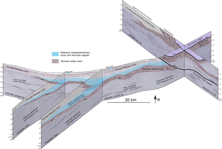
H. Fazlikhani et al.: Variscan structures of the westernmost Bohemian Massif and SE Germany                                          399

Figure 3. Seismo-stratigraphic facies of observed Permian–Jurassic stratigraphy in the study area: (a) Jurassic, (b) Upper Triassic Keuper
Group, (c) Middle Triassic Muschelkalk Group, (d) Lower Triassic Buntsandstein Group, and (d) Permian Zechstein and Rotliegend groups.

tectable boundary (Fig. 4b). The thicknesses of BSF1 units             also observed at the NW end of the DEKORP85-4N pro-
generally decrease westward and reach 2.5 s TWT at their               file (Fig. 5a and b). There, these reflections are associated
deepest position. BSF1 is sampled by the Eltmann well,                 with low-grade Lower Carboniferous flysch deposits (inner
where 94 m of (?Devonian) quartzites and metasedimentary               and outer shelf facies) exposed at the surface (DEKORP Re-
rocks are described (Trusheim, 1964), whereas the Obernsees            search Group, 1994a). Based on seismic facies description
well cored 48.3 m of ?Late Paleozoic metasedimentary rocks             and in the absence of well information, differentiation be-
(Table 1, Stettner and Salger, 1985). Farther north Mittel-            tween allochthons, flysch sedimentary rocks, and inner and
berg well drilled into 100.5 m of Upper Devonian–lower Car-            outer shelf facies is ambiguous. BSF1 is therefore interpreted
boniferous rocks below the Rotliegend (Table 1, (Friedlein             as the western to southwestern extension of low-grade in-
and Hahn, 2018; Hahn et al., 2010). These Upper Devonian–              ner and outer shelf facies, low-grade Lower Carboniferous
Lower Carboniferous rocks (Gleitsch Formation) are inter-              flysch sedimentary rocks, and possible Variscan allochthons
preted as syn-Variscan inner shelf facies sedimentary rocks            (DEKORP Research Group, 1994b). Correlating with ex-
(Thuringian facies), low-grade metamorphosed during the                posed basement units E–NE of the FFS, these units are inter-
Variscan orogeny (Hahn et al., 2010; Kroner et al., 2007).             preted to represent the W–SW extension of the Ziegenrück–
Although the Mittelberg well is not tied to seismic profiles,          Teuschnitz syncline of the Saxothuringian zone.
it additionally confirms the presence of low-grade metasedi-
mentary rocks below the Rotliegend.                                    3.4.2   Basement seismic facies 2 (BSF2)
   In the FFS’s hanging wall, Münchberg Nappe units
(Variscan allochthon) are transected by the DEKORP85-
                                                                       High-amplitude, continuous, and dipping reflection packages
4N and DEKORP-3/MVE-90 seismic profiles (Figs. 1 and
                                                                       are bounding BSF1 at depth and are defined as basement seis-
5, Hirschmann, 1996; Heinrichs et al., 1994). Münchberg
                                                                       mic facies 2 (BSF2, Figs. 4a, c and 5). BSF2 reflections are
Nappe units are surrounded by low-grade metasedimentary
                                                                       not drilled by wells within the survey area. However, similar
rocks of outer shelf facies (Bavarian facies) and inner shelf
                                                                       reflections observed along reprocessed DEKORP85-4N and
facies (Thuringian facies; von Gümbel, 1879; Linnemann et
                                                                       DEKORP-3/MVE-90 profiles below BSF1 can be correlated
al., 2010; Heuse et al., 2010). Exposed nappe units and low-
                                                                       with exposures of highly sheared rocks including phyllites
grade metasedimentary rocks show discontinuous to semi-
                                                                       developed during Variscan tectonics (Fig. 5; DEKORP and
continuous and low-amplitude reflections, similar to BSF1
                                                                       Orogenic Processes Working Group, 1999; Franke and Stein,
of the FRANKEN survey in the FFS footwall (Fig. 5). Simi-
                                                                       2000). We interpret BSF2 as Variscan detachment and shear
lar low-amplitude and low-frequency reflections of BSF1 are
                                                                       zones translating and involving low-grade inner and outer

https://doi.org/10.5194/se-13-393-2022                                                                Solid Earth, 13, 393–416, 2022
400                       H. Fazlikhani et al.: Variscan structures of the westernmost Bohemian Massif and SE Germany

                                                                     3.4.3    Basement seismic facies 3 (BSF3)

                                                                     Basement seismic facies 3 (BSF3) is characterized by semi-
                                                                     continuous and medium-amplitude reflections (Fig. 4a and
                                                                     d). BSF3 is bounded by BSF2 at the top and extends to the
                                                                     lower limit of the dataset at 8 s TWT. BSF3 does not show
                                                                     any preferential dip direction and locally hosts some higher-
                                                                     amplitude, continuous, and dipping reflections of BSF2.
                                                                     Such high-amplitude reflections of BSF2 are branching off
                                                                     the main BSF2 packages or are developed at deeper lev-
                                                                     els and are interpreted as segments of major shear zones or
                                                                     locally developed shear zones of Variscan origin. BSF3 is
                                                                     not drilled by wells, nevertheless considering the tectonos-
                                                                     tratigraphic position of BSF3 below the Variscan detach-
                                                                     ment/shear zones (BSF2), BSF3 is interpreted to represent
                                                                     Cadomian basement rocks and overlying Paleozoic inner
                                                                     shelf facies not involved in Variscan tectonics.

                                                                     4     Seismic reflection interpretation of the FRANKEN
                                                                           seismic survey

                                                                     Described seismic facies in the sedimentary cover and under-
                                                                     lying basement units and well information are utilized in this
                                                                     chapter to interpret the FRANKEN seismic profiles.
Figure 4. Basement seismic facies (BSF) described along the
FRANKEN seismic survey. Panel (a) shows the SE portion of            4.1     Profile FRANKEN-1801
FRANKEN-1804 below the Top Zechstein horizon. (b) Low-
amplitude and discontinuous reflections of BSF1 interpreted as Pa-   Profile FRANKEN-1801 is 47.9 km long and extends NW–
leozoic metasedimentary rocks and Variscan nappe units. (c) BSF2     SE from south of Bamberg to the NW of Haßfurt (Fig. 1). At
shows high-amplitude, continuous, and dipping reflections inter-     the surface, mainly Keuper units are exposed (Fig. 1). Thick-
preted as Variscan shear zones. (d) Medium-amplitude and semi-       nesses of remnant Keuper units progressively decrease to the
continuous reflections of BSF3 below the Variscan shear zone re-     W–NW, and at the northwestern edge of profile FRANKEN-
lated to the Cadomian basement and Paleozoic inner shelf facies      1801 Muschelkalk units are exposed at the surface in the
not involved in Variscan tectonics.                                  footwall of a segment of the Kissingen–Haßfurt Fault zone
                                                                     (Fig. 6). This fault zone is mapped over ca. 60 km with ca.
                                                                     7–10 km width and is sub-parallel to the NW–SE-striking
shelf facies, low-grade Lower Carboniferous flysch sedimen-          FRANKEN-1801 profile (Fig. 1). Some segments of the
tary rocks, and Variscan nappes. BSF2 therefore includes             Kissingen–Haßfurt Fault zone are oblique and are imaged
the upper parts of the Saxothuringian parautochthons (highly         by the FRANKEN-1801 profile. Muschelkalk and Buntsand-
sheared parts of inner shelf facies) and lower parts of al-          stein units are fairly tabular with no major lateral thick-
lochthons. Similar intra-basement, high-amplitude and dip-           ness changes (Fig. 6). Most of the interpreted faults (seis-
ping reflections are interpreted as orogenic and post-orogenic       mic scale) are normal faults, while major reverse faults are
shear zones in the Norwegian Caledonides (Phillips et al.,           sub-parallel to the profile and are not imaged in FRANKEN-
2016; Fazlikhani et al., 2017; Wrona et al., 2020; Osagiede          1801.
et al., 2019), offshore of Brazil (Strugale et al., 2021; Vas-          Below the Buntsandstein, Permian deposits including
concelos et al., 2019), offshore of New Zealand (Collanega           114 m Zechstein and 3 m Rotliegend have been drilled by the
et al., 2019; Phillips and McCaffrey, 2019), and in the South        Eltmann well, 2230 m to the NE of profile FRANKEN-1801
China Sea (Ye et al., 2020). High-amplitude and continuous           (Fig. 6) (Trusheim, 1964). Semi-continuous and medium-
reflections of BSF2 below the Münchberg Nappe and across             amplitude reflections below the Zechstein are interpreted
the FFS to the west are therefore interpreted as the W–SW ex-        as Rotliegend deposits (Fig. 6). As the Rotliegend base
tension of a Variscan detachment and shear zone transporting         is not particularly reflective in the seismic reflection data,
allochthonous nappes and underlying metasedimentary rocks            it is difficult to interpret the top basement. Towards the
W–SW towards the Franconian Basin area. BSF2 reflections             NW in the center of the FRANKEN-1801 profile, BSF1
generally get shallower from east to west and reach the base         reflections (Paleozoic metasedimentary rocks and Variscan
of the overlying sedimentary units.                                  nappes) are present below the Permian rocks and are under-

Solid Earth, 13, 393–416, 2022                                                           https://doi.org/10.5194/se-13-393-2022
H. Fazlikhani et al.: Variscan structures of the westernmost Bohemian Massif and SE Germany 401
Figure 5. Reprocessed DEKORP-85 4N and DEKORP-3/MVE-90 profiles used to compare three basement seismic facies (BSF1-3) de-
scribed along the FRANKEN seismic survey (see Fig. 1 for locations). DEKORP profiles image exposed Variscan units along the western
Bohemian Massif and are used as proxy for geological interpretation of BSFs. (a) DEKORP-85 4N shows the seismic signature of Paleozoic
low-grade metasedimentary rocks (zoomed in b) and Münchberg Nappe (Variscan allochthon, zoomed in c) exposed at the surface and de-
scribed as BSF1. (d) DEKORP-3/MVE-90 images of Münchberg Nappe units to the east and Permian–Jurassic sedimentary cover to the west
of Franconian Fault System (FFS). Panel (e) shows the seismic signature of Variscan nappes (BSF1) and underlying shear zones (BSF2).
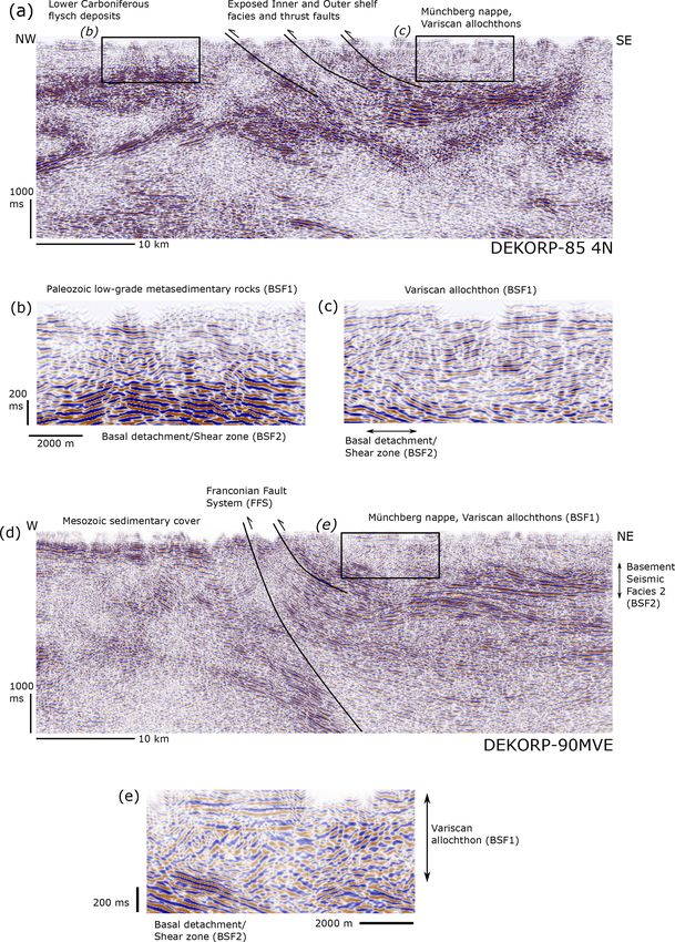
lain by a Variscan shear zone (BSF2, Fig. 6). From the SE, 4.2 Profile FRANKEN-1802
the Variscan shear zone shallows to the NW and reaches ca.
700 ms TWT at the center of the profile (Fig. 6). Profile FRANKEN-1802 extends NE–SW with 47.7 km
length (Fig. 1). This profile is at a high angle to the promi-
nent NW–SE faults and therefore provides a good subsur-
face image of these structures (Fig. 7). Profile FRANKEN-
1802 is tied to the Eltmann well and runs close to the
https://doi.org/10.5194/se-13-393-2022 Solid Earth, 13, 393–416, 2022
402                       H. Fazlikhani et al.: Variscan structures of the westernmost Bohemian Massif and SE Germany

Figure 6. (a) Uninterpreted and (b) interpreted FRANKEN-1801 profile. Horizon interpretation is tied to drilled wells in the study area.
(c) Depth-converted profile with no vertical exaggeration. Intersecting profiles FRANKEN 1802 and 1804 are shown by black arrows. See
Fig. 1 for the profile location.

Mürsbach 6 (630 m to the S), Staffelstein 1 (1235 m, to               and 6, and Staffelstein 1 wells without reaching the underly-
the SE), and Staffelstein 2 wells (890 m, to the SE). Pro-            ing basement, except in the Eltmann well (Table 1). Medium-
file FRANKEN-1802 is used as the reference profile for the            amplitude and semi-continuous reflections, characteristic of
seismo-stratigraphic interpretation (Fig. 7). Jurassic rocks          the Rotliegend in the study area, are also locally observed,
are preserved in the footwall of the Mürsbach and Lichtenfels         suggesting the presence of Rotliegend laterally away from
reverse faults drilled with 104 m thickness by well Staffel-          wells (Fig. 7). Rotliegend units are wedge shaped and are
stein 2 (Table 1; Gudden, 1977). Keuper strata are exposed in         tilted to the E–NE, onlapping to deep-sited W–SW-dipping
the hanging wall of the Lichtenfels Fault at the northeastern         normal faults in the footwall of the Mürsbach and Lichten-
edge of profile FRANKEN-1802 (Fig. 7). Keuper is drilled              fels reverse faults (Fig. 7). Interpreted W–SW-dipping nor-
with 532 m in thickness by the Staffelstein 2 well. Towards           mal faults appear to be crosscut by the oppositely dipping (E–
the SW the Keuper is increasingly eroded, and only 178.6 m            NE) Lichtenfels and Mürsbach reverse faults in Buntsand-
are preserved at the location of the Eltmann well (Fig. 7 and         stein units (Fig. 7). E–NE block rotation in the hanging wall
Table 1, Gudden, 1977; Trusheim, 1964). Muschelkalk and               of these normal faults created local half-grabens observed ex-
Buntsandstein sedimentary rocks are tabular and regionally            clusively in the Rotliegend section (Fig. 7). In the hanging
dip to the E–NE (Fig. 7). The Zechstein is penetrated by the          wall of a normal fault located in the footwall of Lichtenfels
Eltmann, Mürsbach 1 and 6, and Staffelstein 1 wells and is            Fault, the thickness of the Permian section is > 330 ms TWT
103–121 m thick (Table 1; Gudden, 1985). Below the Zech-              (ca. 640 m) that thins W–SW to ca. 120 ms TWT (ca. 240 m)
stein units, Rotliegend is drilled by the Eltmann, Mürsbach 1         in the hanging wall of the Mürsbach Fault (Fig. 7). The in-

Solid Earth, 13, 393–416, 2022                                                              https://doi.org/10.5194/se-13-393-2022
H. Fazlikhani et al.: Variscan structures of the westernmost Bohemian Massif and SE Germany                                   403

terpretation of lateral thickness changes in the Permian is in    nor lateral thickness changes. At the Obernsees well, the
good accordance with 142.3 m minimum thickness of Per-            Rotliegend is only 18.3 m thick overlying metasedimen-
mian drilled in the Mürsbach 6 well (Table 1). The thickness      tary rocks of possible Late Paleozoic age (Stettner and Sal-
of the Permian section in the hanging wall of Bamberg Fault       ger, 1985; Ravidà et al., 2021). The reduced thickness of
is > 200 ms TWT (ca. 390 m), decreasing to the W–SW down          Rotliegend units in the Obernsees well is related to a lo-
to the 3 m drilled at the Eltmann well (Fig. 7).                  cal basement high in the footwall of an ESE-dipping nor-
   Sedimentary units in the hanging wall of the Lichtenfels       mal fault (Fig. 8). In the hanging wall of this normal fault
Fault are uplifted and gently folded where the entire Juras-      and to the SE, medium-amplitude and semi-continuous re-
sic and the upper parts of the Upper Triassic Keuper Group        flections below the top Zechstein horizon are interpreted as
are eroded (Fig. 7). In the footwall of the Lichtenfels Fault,    Rotliegend (Fig. 8, Stettner and Salger, 1985; Schuh, 1985).
sedimentary units are folded by a normal drag fold, creating      Permian units are underlain by Paleozoic metasedimentary
a local synformal structure (also known as the Hollfeld syn-      rocks and Variscan nappes (BSF1 units, Fig. 8). BSF2 reflec-
cline) where Jurassic rocks are preserved (Fig. 7). The NW–       tions are sub-horizontal (between 2000–2500 ms, TWT) and
SE-striking Lichtenfels Fault is laterally and vertically seg-    gradually get shallower to the NW to reach to ca. 1200 ms
mented and is exposed at the surface over ca. 16 km length        TWT. From the SE to the center of the profile, BSF2 reflec-
(Fig. 1). In profile FRANKEN-1802, the Lichtenfels Fault          tions become less pronounced and appear to be segmented
has 135 ms TWT (ca. 260 m) throw when measured at the             into a steeper and a sub-horizontal segment (Fig. 8). Farther
top of the Buntsandstein (Fig. 7). The Mürsbach Fault strikes     NW, BSF2 reflections reach to a shallower depth and are also
NNW–SSE over ca. 5 km and has been imaged by the Mürs-            imaged by the perpendicular FRANKEN-1802 and 1804 pro-
bach seismic survey along three short (< 4 km) 2D seismic         files. Lateral segmentation and changes in the reflectivity of
sections (Flemm et al., unpublished data). The Mürsbach           the BSF2 might be related to the 3D geometry of an inter-
Fault shows ca. 65 ms TWT (ca. 120 m) throw measured              preted detachment or shear zone (Fig. 8).
at the Buntsandstein top. Both the Muschelkalk and Keu-
per units are folded, creating a local anticline in the hanging   4.4   Profile FRANKEN-1804
wall of the Mürsbach Fault. Upper parts of the Keuper and
younger units are both eroded on the hanging wall side, while     This profile strikes NE–SW over 63.3 km and is subparal-
in the immediate footwall some of the Jurassic units are still    lel to the profile FRANKEN-1802 (Fig. 9). Jurassic units
preserved (Fig. 7). E–NE-dipping normal faults interpreted        are preserved in the NE and the central part of the pro-
in the SW part of the profile FRANKEN-1802 are subparal-          file. However, to the SW Jurassic units are eroded and Ke-
lel to the SE extension of the Kissingen-Haßfurt Fault Zone       uper sandstones are exposed at the surface (Fig. 9). Geome-
(Fig. 7).                                                         tries of Triassic units are fairly tabular, generally with shal-
   In the Eltmann well, 94 m of ?Devonian metasedimentary         low dips to the NE–E but with variable dip angles between
rocks are drilled below the sedimentary cover and correlated      fault blocks. High-amplitude and continuous reflections be-
with BSF1 (Fig. 7; Trusheim, 1964). Identified BSF1 units         low the Triassic units are interpreted as Zechstein and are
are ca. 800 ms TWT (ca. 1560 m) thick in the NE of the seis-      correlated with similar reflection packages in perpendicu-
mic section, decreasing to 94 m towards the SW at the loca-       lar profiles FRANKEN-1801 and 1803. Semi-continuous and
tion of well Eltmann. BSF2 reflections show a concave up          medium-amplitude reflections beneath the Zechstein are in-
geometry below the Lichtenfels and Mürsbach faults and ex-        terpreted as Rotliegend that locally overlaps with the hanging
tend to shallower depth towards the west (Fig. 7). In the cen-    wall of deep-seated W-to-SW-dipping normal faults (Fig. 9).
ter of the profile some high-amplitude reflections of BSF2        In general, Permian units are wedge shaped in the hanging
branch off from the main reflection package and extend into       walls of normal faults and laterally thin. Paleozoic metased-
the deeper parts of the crust (Fig. 7).                           imentary units and Variscan nappes (BSF1) underlie the Per-
                                                                  mian and are ca. 1400 ms TWT (ca. 2700 m) thick in the
4.3   Profile FRANKEN-1803                                        center of the profile but laterally thin. The Variscan shear
                                                                  zone (BSF2) underlying Paleozoic metasedimentary units
This profile is subparallel to the profile FRANKEN-1801 and       and Variscan nappes are concave-shaped in the NE and reach
strikes NW–SE over 71.8 km length (Fig. 1). The Obernsees         to shallower depths toward the southwestern edge of the pro-
well is located 945 m SW of this profile and drilled into         file FRANKEN-1804 (Fig. 9). In the center of the profile,
140 m of Jurassic units, the entire Triassic succession, and      BSF2 reflections are observed at greater depth up to about
104.9 m of upper Permian Zechstein units (Table 1 and Fig. 8,     3000 ms TWT and are slightly less reflective. The Cado-
Helmkampf, 2006). Jurassic units are preserved at the sur-        mian basement and parts of inner shelf facies not involved
face, except in the SE and NW parts of profile 1803, in-          in Variscan tectonics (BSF3) characterize the deeper parts of
dicating a gentle synformal geometry, with remnant Juras-         the profile FRANKEN-1804 (Fig. 9).
sic units being thickest in the center of the profile (Fig. 8).      At the NE edge of the profile FRANKEN-1804, the
Triassic intervals show subparallel boundaries with only mi-      Eisfeld–Kulmbach Fault accumulates ca. 660 ms TWT (ca.

https://doi.org/10.5194/se-13-393-2022                                                         Solid Earth, 13, 393–416, 2022
404 H. Fazlikhani et al.: Variscan structures of the westernmost Bohemian Massif and SE Germany Figure 7. The FRANKEN-1802 profile strikes NE–SW, perpendicular to the main structures. (a) Uninterpreted and (b) interpreted seismic profile. FRANKEN-1802 is tied to the Eltmann, Mürsbach, and Staffelstein 1 and 2 wells. High-amplitude and continuous reflection of BSF2 interpreted as Variscan shear zones are at 2000–2500 ms TWT (5–6.5 km) in the NE and reach to the base of Permian sedimentary rocks to the SE. Vertical exaggeration is 5×. (c) Depth-converted section with no vertical exaggeration. See Fig. 1 for the profile location. 1280 m) of throw, exposing Buntsandstein in its hanging wall Fault is a major normal fault displacing the Triassic and Per- (Fig. 9). Across the fault, Jurassic units are preserved in the mian units with ca. 40 ms TWT (ca. 80 m) offset measured footwall and are thin towards the SW, where they are eroded at top Muschelkalk. Bamberg Fault detaches into the under- in the hanging wall of the Asslitz Fault (Fig. 9). The Asslitz lying Variscan shear zone (BSF2) at depth (Fig. 9). Farther Fault accumulates ca. 210 ms TWT (ca. 420 m) of throw at north along the FRANKEN-1802 profile, Bamberg fault is the top of the Buntsandstein. Farther SW, the Lichtenfels displaced by the Mürsbach reverse fault (Fig. 7). Fault offsets Permian to Upper Triassic units with ca. 90 ms TWT (ca. 170 m) of throw measured at the Muschelkalk top. In contrast to profile FRANKEN-1802 (ca. 9 km NW), along 5 Discussion the FRANKEN-1804 profile the Lichtenfels Fault does not reach to the surface and dies out within the Keuper units. 5.1 Westward extension of the Saxothuringian zone In the footwall of Lichtenfels Fault, a W-to-SW-dipping nor- mal fault creates a local half-graben where continuous and Exposed Variscan allochthons are tectonically placed above medium-amplitude reflections are onlapping and terminat- the Paleozoic outer shelf facies (Bavarian facies), which ing against the fault (Fig. 9). Further to the SW, Bamberg are defined as fine-grained and clay-rich material preserved Solid Earth, 13, 393–416, 2022 https://doi.org/10.5194/se-13-393-2022
H. Fazlikhani et al.: Variscan structures of the westernmost Bohemian Massif and SE Germany                                         405

Figure 8. The SE–NW-striking FRANKEN-1803 profile, sub-parallel to the FRANKEN-1801 profile. Horizon interpretation is tied to the
Obernsees well and the intersection of the FRANKEN 1801 and 1804 profiles. (a) Uninterpreted and (b) interpreted profile. (c) A depth-
converted section with no vertical exaggeration. Interpreted Variscan shear zones (BSF2) are at 2000–3000 ms (5–7 km) in the SE and reach
to ca. 2.5 km depth toward the NW.

around and below Variscan nappe piles (Linnemann and                   study area, no well has probed the Variscan nappes west of
Heuse, 2001; Franke and Stein, 2000). BSF1 units observed              the FFS yet. Seismic signatures of exposed Variscan nappes
beneath the sedimentary cover west of the FFS (Figs. 7 and             and low-grade metasedimentary rocks east of the FFS do
9) are interpreted as equivalents of Paleozoic metasedimen-            not allow differentiation between nappes and metasedimen-
tary rocks and Variscan nappe units (e.g., Münchberg Nappe,            tary rocks. Similar observations have been made in the Cale-
Fig. 10). BSF1 units are mapped as far as ca. 65 km west of            donides of western Norway (Fazlikhani et al., 2017; Lenhart
the FFS and thin towards the NW along the NW–SE-striking               et al., 2019). Differentiation of Paleozoic inner and outer
profiles (Figs. 6 and 8) and towards the SW along the NE–              shelf facies is also beyond the resolution of available seis-
SW-striking profiles (Figs. 7 and 9), showing a general west-          mic reflection data. However, the tectonostratigraphic posi-
ward thinning of Variscan nappes and Paleozoic metasedi-               tion of Variscan nappes and metasedimentary rocks relative
mentary rocks. Wells drilled in the Schwarzwald and Upper              to basal shear zones in exposed basement units east of the
Rhein Graben areas (ca. 300 km SW of the study area) show              FFS (Heuse et al., 2010; Linnemann et al., 2010) supports
low-grade metasedimentary units (shales and phyllites) and             the possible presence of Variscan nappes and underlying in-
volcanic rocks below sedimentary cover, interpreted as SW              ner and outer shelf facies ca. 65 km west of FFS (Fig. 10).
extension of the Saxothuringian Zone (Franke et al., 2017).               In the exposed parts of the Saxothuringian zone east of
Although seismic reflection and a few well data confirm the            FFS, kinematic indicators show a top to W–SW tectonic
presence of low-grade to very low-grade metasedimentary                transport under NE–SW compression (Schwan, 1974). This
rocks below the Permian to Jurassic sedimentary cover in the           deformation phase has been described as “D1” deformation

https://doi.org/10.5194/se-13-393-2022                                                               Solid Earth, 13, 393–416, 2022
406                      H. Fazlikhani et al.: Variscan structures of the westernmost Bohemian Massif and SE Germany

Figure 9. (a) Uninterpreted and (b) interpreted FRANKEN-1804 profile. Horizon interpretation along this profile is tied to the FRANKEN
1801 and 1803 intersection profiles. Note the overlapping reflections in the hanging wall of SW-dipping normal faults creating Permian
half-grabens. (c) A depth-converted section with no vertical exaggeration. See Fig. 1 for the profile location.

phase and is related to the subduction and collision during          5.2   Shear zone topography and strain localization
the Variscan orogeny before ca. 340 Ma (Kroner et al., 2007).              during brittle deformation
For the assemblage of the Variscan during the subduction and
collision, a NW tectonic transport under a NW–SE compres-            A regional NW–SE-dominated compressional and dex-
sion has also been proposed Franke and Stein (2000). Ob-             tral transpressional phase at ca. 340–330 Ma affected the
served regional westward shallowing of mapped thrust shear           Saxothuringian zone and most likely reactivated preexisting
zones west of the FFS could have been developed under                D1 shear zones, including the Münchberg Shear Zone (MSZ,
both proposed tectonic transport directions. Seismic reflec-         Franke, 2000; Kroner et al., 2007). The 340–330 Ma defor-
tion data do not allow for the definition of a preferred tec-        mation phase might have been responsible for modifying the
tonic transport direction; however, based on the kinematic           initial geometry of the mapped shear zone by folding and
indicators observed and described in the exposed parts of the        bending (Figs. 7 and 9). Latest to post-orogenic normal faults
Saxothuringian Zone, we tend to prefer the W–SW transport            appear to have developed at a wide range of vertical and lat-
direction.                                                           eral scales in response to the regional stress field. These nor-
                                                                     mal faults propagated radially and created larger faults (e.g.,
                                                                     Fazlikhani et al., 2021). However, only the ones that detach
                                                                     into the shear zone or preexisting thrust faults at depth grew

Solid Earth, 13, 393–416, 2022                                                            https://doi.org/10.5194/se-13-393-2022
H. Fazlikhani et al.: Variscan structures of the westernmost Bohemian Massif and SE Germany 407 Figure 10. Present-day three-dimensional view of interpreted Variscan units and structures west of the Franconian Fault System (FFS). Variscan shear zone shows synformal and anti-formal geometries shallowing and thinning toward the W–SW. further and potentially reactivated parts of the shear zone on ization and brittle reactivation of orogenic shear zones dur- their hanging wall side, while other normal faults became in- ing initiation and activity of post-orogenic brittle faults has active (Figs. 7, 9 and 11b). been described from the post-Caledonian tectonics in Scan- All the major reverse faults (Eisfeld–Kulmbach, Asslitz, dinavia (Fazlikhani et al., 2017; Phillips et al., 2016; Koehl Lichtenfels (northern portion) and Mürsbach) most likely de- et al., 2018; Wiest et al., 2020) and post-Variscan tectonics of veloped in response to Cretaceous inversion events in central the Western Alps (Festa et al., 2020; Ballèvre et al., 2018). Europe (Kley and Voigt, 2008) and concentrate around the The geometry of shear zones, which creates local ramps, anti-formal parts of the shear zone. For example, along the also appears to influence the magnitude of fault offset in the FRANKEN-1802 profile, the Lichtenfels Fault developed on study area. In the northeastern part of FRANKEN-1802 pro- top of the folded portion of the underlying shear zone and it is file where the Variscan shear zone shows anti-formal geom- exposed at the surface (Fig. 7). Conversely, ca. 10 km farther etry, the Lichtenfels Fault accumulates ca. 180 ms TWT of south along the FRANKEN-1804 profile where the underly- throw at the top Muschelkalk horizon and is exposed at the ing shear zone shows a rather flat geometry, the Lichtenfels surface. Along the FRANKEN-1804 profile, ca. 10 km far- Fault does not reach to the surface (Fig. 9). Similarly, the ther south, where the Variscan shear zone shows a rather flat Mürsbach reverse fault in the footwall of the Bamberg nor- geometry, the Lichtenfels Fault has only ca. 90 ms TWT of mal fault (or a similar normal fault) developed on top of the throw and is a blind fault tipping out in the Keuper units. In folded portion of the shear zones and dies out laterally to addition, the anti-formal parts of the shear zone generally ex- the south where the shear zone is rather flat (Figs. 7 and 9). perience more upper-crustal brittle deformation (normal and Our observations demonstrate that the anti-formal geometry reverse faulting; Figs. 7 and 9). It should be noted that to- of shear zones perturbs the regional stress field and localizes wards the east, at the margin of the Franconian Basin, the the strain, facilitating lateral and vertical growth of preferen- FFS as the major basin-bounding fault system displaces the tially located brittle faults (Fig. 12). Comparable strain local- basal detachment or shear zone, exposing Variscan basement https://doi.org/10.5194/se-13-393-2022 Solid Earth, 13, 393–416, 2022
408                        H. Fazlikhani et al.: Variscan structures of the westernmost Bohemian Massif and SE Germany

Figure 11. Simplified and generic cartoons showing the relationships between orogenic structures and post-orogenic fault and basin devel-
opment (note that the shown general W-directed tectonic transport refers to the initial W–SW-directed nappe stacking). At the latest orogenic
and early post-orogenic period, normal faults develop in response to the regional stress field, with some being sub-parallel to the preexist-
ing orogenic structures. Some of the normal faults grow laterally, vertically detach into the underlying shear zones, and initiate graben and
half-graben basins on their hanging wall side. Normal faults not detaching into preexisting shear zones are abandoned. After a Triassic and
Jurassic regional tectonic quiescence, Cretaceous inversion events in Central Europe selectively reactivate Permian normal faults as steep
reverse faults, exposing older stratigraphy in the hanging wall side and creating local synclines and anticlines in the vicinity of reactivated
faults.

units in the hanging wall side. The fact that reverse faults ac-          ening direction, are thus important controlling factors in the
commodated a few hundred meters of offset and detach into                 reactivation or displacement of the basal detachment or shear
shear zones, while the FFS, which accommodated ca. 3 km                   zone by brittle faults (Daly et al., 1989; Ring, 1994; Peace et
of offset (Wagner et al., 1997), displaces the shear zone, in-            al., 2018; Heilman et al., 2019; Phillips et al., 2019).
dicates that accumulation of a large amount of offset on a
fault stimulates it to break through and displace the underly-
ing shear zone. The amount of fault offset and the previously
shown mechanical and rheological properties of shear zones,
as well as their orientation relative to the extension and short-

Solid Earth, 13, 393–416, 2022                                                                  https://doi.org/10.5194/se-13-393-2022
You can also read