WINOOSKI AVENUE TRANSPORTATION STUDY REPORT - Chittenden ...
←
→
Page content transcription
If your browser does not render page correctly, please read the page content below

Chittenden County Regional Planning Commission & City of Burlington

                                    WINOOSKI AVENUE
                                    TRANSPORTATION STUDY REPORT
                                    REPORT │ January 31, 2020

w

                                    PREPARED FOR:
                                    CHITTENDEN COUNTY REGIONAL PLANNING COMMISSION & CITY OF BURLINGTON
    180 Battery Street, Suite 350   SUBMITTED BY:
           Burlington, VT 05401     RSG
                   802.383.0118     IN COOPERATION WITH:
               www.rsginc.com       DUBOIS & KING, STREETPLANS, THIRD SECTOR ASSOCIATES
Disclaimer
"The preparation of this report has been financed in part through grant[s] from the Federal Highway Administration and Federal
 Transit Administration, U.S. Department of Transportation, under the State Planning and Research Program, Section 505 [or
Metropolitan Planning Program, Section 104(f)] of Title 23, U.S. Code. The contents of this report do not necessarily reflect the
                                official views or policy of the U.S. Department of Transportation."
Chittenden County Regional Planning Commission & City of Burlington
  WINOOSKI AVENUE TRANSPORTATION STUDY: EXISTING CONDITIONS REPORT

CONTENTS
EXECUTIVE SUMMARY ............................................................... IV                                    DELIVERY VEHICLES .............................................................. 24
1.0 INTRODUCTION....................................................................... 1                               SHARED MOBILITY .................................................................. 25
     1.2 STUDY OUTCOMES .................................................................... 2                          TAKING TRANSIT ..................................................................... 25
     1.3 CORRIDOR VISION ..................................................................... 2                  3.3 SAFETY ...................................................................................... 29
     1.4 INTEGRATION OF MODES ......................................................... 4                               CRASH HISTORY ..................................................................... 29
     1.5 PROJECT GOVERNANCE ........................................................... 4                               SPEEDS .................................................................................... 33

2.0 LITERATURE REVIEW ............................................................ 5                              3.4 PARKING ANALYSIS ................................................................. 34

     2.1 STUDIES ...................................................................................... 5               ON-STREET PARKING ............................................................. 34

     2.2 PLANS .......................................................................................... 6             OFF-STREET PARKING ........................................................... 35

3.0 EXISTING CONDITIONS .......................................................... 9                                    EXISTING DEMAND VS. SUPPLY............................................ 35
                                                                                                                        SMART USE .............................................................................. 37
     3.1 LAND USE .................................................................................... 9
           HOUSING AND EMPLOYMENT ............................................... 10                          4.0 PUBLIC ENGAGEMENT ........................................................ 38
     3.2 MULTIMODAL INFRASTRUCTURE ........................................... 12                                 4.1 OVERVIEW ................................................................................ 38

           WALKING .................................................................................. 13          4.2 PROJECT ADVISORY COMMITTEE (PAC) .............................. 38

           BICYCLING ............................................................................... 16           4.3 PUBLIC MEETINGS ................................................................... 39

           BIKESHARING .......................................................................... 19                    PUBLIC MEETING 1 ................................................................. 39

           DRIVING .................................................................................... 20              PUBLIC MEETING 2 ................................................................. 40

           CARSHARING ........................................................................... 24                    PUBLIC MEETING 3 ................................................................. 41

                                                                                                                                                                                                                         i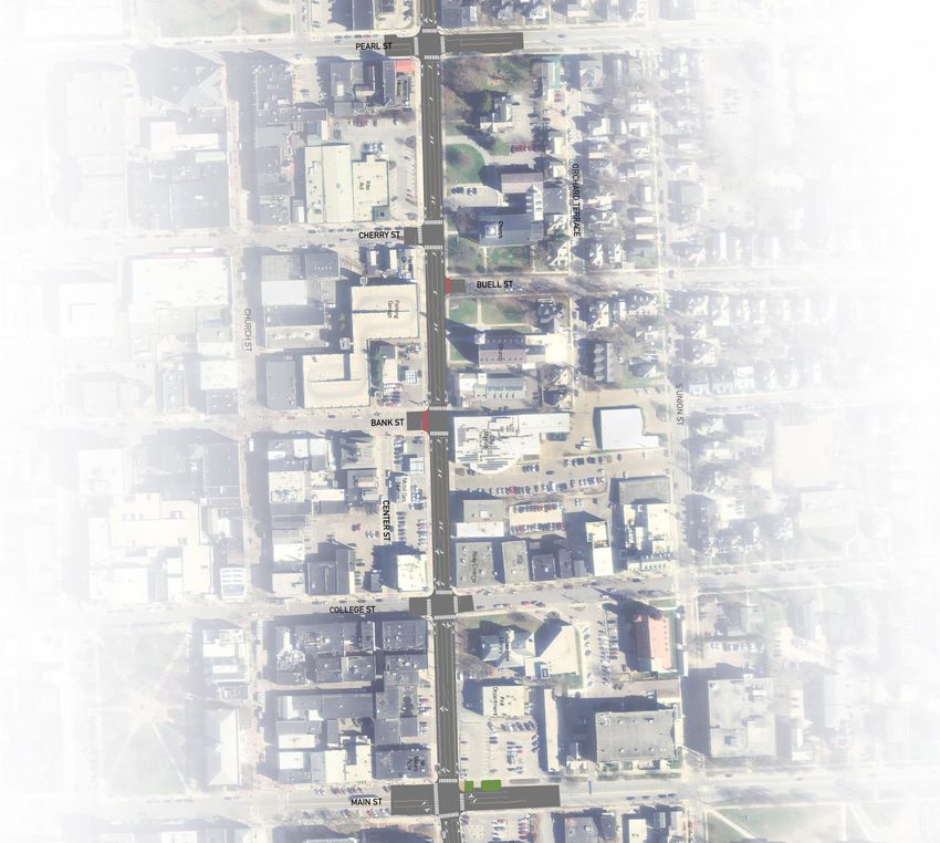
4.4 STAKEHOLDER INTERVIEWS .................................................. 41                                PEARL STREET TO UNION STREET/DECATUR STREET ..... 61
          VEHICLE PARKING .................................................................. 42                     NORTH STREET INTERSECTION ........................................... 62
          BICYCLE FACILITIES AND BICYCLE PARKING ..................... 43                                           UNION STREET INTERSECTION ............................................ 63
          PEDESTRIAN AMENITIES ........................................................ 43                          PEARL STREET INTERSECTION ............................................ 64
          ONE-WAY VERSUS TWO-WAY TRAFFIC PATTERN.............. 43                                              6.4 DOWNTOWN SEGMENT: PEARL STREET TO MAIN STREET 65
          TRANSIT ................................................................................... 43            BANK STREET INTERSECTION/CITY MARKET DRIVEWAY . 66
          MAIN STREET TO PEARL STREET ......................................... 43                                  MAIN STREET INTERSECTION ............................................... 66
          OPEN STREETS BTV SUMMARY ............................................ 44                             6.5 SOUTHERN SEGMENT: MAIN STREET TO SAINT
                                                                                                                   PAUL/HOWARD ........................................................................ 67
          OLD NORTH END BUSINESS SUMMARY ............................... 44
                                                                                                                    MAIN STREET TO KING STREET ............................................ 67
    4.5 CONTINUOUS COMMUNICATION ............................................ 45
                                                                                                                    KING STREET TO MAPLE STREET......................................... 68
    4.6 SPECIFIC CHALLENGES WITHIN THE CORRIDOR ................ 46
                                                                                                               6.6 PROJECT COSTS ...................................................................... 68
5.0 PROJECT ALTERNATIVES .................................................. 48
                                                                                                                    SHORTER-TERM ...................................................................... 68
    5.1 OVERVIEW ................................................................................. 48
                                                                                                                    LONGER-TERM ........................................................................ 68
    5.2 INTERSECTIONS AND SEGMENTS ......................................... 48
                                                                                                               6.7 IMPLEMENTATION TIMELINE .................................................. 69
          ROUNDABOUTS ....................................................................... 48
                                                                                                                    NORTHERN SEGMENT ............................................................ 69
          MINI-ROUNDABOUTS .............................................................. 49
                                                                                                                    DOWNTOWN SEGMENT .......................................................... 70
          ROUNDABOUTS AND BICYCLE LANES ................................. 49
                                                                                                                    SOUTHERN SEGMENT ............................................................ 71
          PUTTING IT TOGETHER .......................................................... 49
                                                                                                           APPENDIX A. PROJECT ADVISORY COMMITTEE ................. A-1
    5.3 SCHEMATICS ............................................................................ 49
    5.4 EVALUATING THE ALTERNATIVES ......................................... 54                           APPENDIX B. PUBLIC COMMENTS ......................................... B-1
    5.5 RECOMMENDED ALTERNATIVE .............................................. 56                          APPENDIX C. ALTERNATIVES EVALUATION ........................ C-1
    5.6 PREFERRED ALTERNATIVE .................................................... 57                      APPENDIX D. TRAFFIC ANALYSIS .......................................... D-1
6.0 IMPLEMENTING THE PLAN ................................................. 58                             APPENDIX E. OPINION OF PROBABLE COST ....................... E-1
    6.1 PREFERRED ALTERNATIVES SELECTION ............................. 58
    6.2 PREFERRED ALTERNATIVES SUMMARY ............................... 58
          INTERIM IMPROVEMENTS ...................................................... 58
          SHORTER-TERM IMPROVEMENTS ........................................ 58
          LONGER-TERM IMPROVEMENTS .......................................... 59
    6.3 NORTHERN SEGMENT: RIVERSIDE AVENUE TO PEARL
        STREET..................................................................................... 60

   ii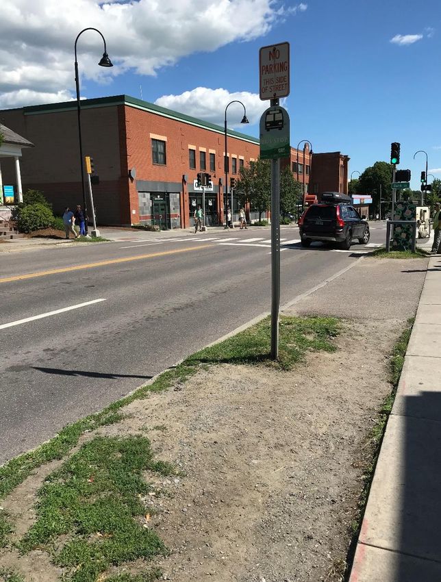
LIST OF FIGURES FIGURE 35: PROJECT WEBSITE ............................................................................... 45
FIGURE 36: WIKIMAPPING EXISTING CONDITIONS WEB-SURVEY ....................... 46
FIGURE 1: STUDY AREA .............................................................................................. 1 FIGURE 37: CHALLENGES EXPERIENCED ON THE STUDY CORRIDOR ............... 47
FIGURE 2: BURLINGTON'S MODE SHARE—PAST, PRESENT, AND FIGURE 38: MAIN ST. ROUNDABOUT SKETCH - 130' DIAMETER .......................... 49
FUTURE GOAL ...................................................................................................... 3 FIGURE 39: SCHEMATIC—ALTERNATIVE 1 ............................................................. 51
FIGURE 3: PROJECT TEAM STRUCTURE................................................................... 4 FIGURE 40: SCHEMATIC—ALTERNATIVE 2 ............................................................. 52
FIGURE 4: CITY ZONING DISTRICTS........................................................................... 9 FIGURE 41: SCHEMATIC—ALTERNATIVE 3 ............................................................. 53
FIGURE 5: HOUSING DENSITY AND LOCATIONS (2015) ......................................... 10 FIGURE 42: CORRIDOR EVALUATION SCORES ...................................................... 55
FIGURE 6: EMPLOYMENT DENSITY AND LOCATIONS ........................................... 11 FIGURE 43: EVALUATION PROCESS........................................................................ 56
FIGURE 7: CURB CUT (DRIVEWAY) DENSITY .......................................................... 11 FIGURE 44: NORTH STREET INTERSECTION—SHORTER TERM ........................... 62
FIGURE 8: CROSS-SECTION OVERVIEW ................................................................. 12 FIGURE 45: NORTH STREET INTERSECTION—LONGER TERM ............................. 62
FIGURE 9: WIDE SIDEWALK WITH STREET TREES OUTSIDE CITY FIGURE 46: UNION STREET INTERSECTION—SHORTER TERM ............................ 63
MARKET, ADJACENT TO FOUR LANES OF TRAFFIC ON WINOOSKI FIGURE 47: UNION STREET INTERSECTION—LONGER TERM .............................. 63
AVENUE .............................................................................................................. 13 FIGURE 48: PEARL STREET LOADING ZONE POSSIBILITY ................................... 64
FIGURE 10: TYPICAL SIDEWALK ALONG WINOOSKI AVENUE OUTSIDE FIGURE 49: PEARL STREET INTERSECTION—SHORTER TERM ........................... 64
OF THE DOWNTOWN CORE .............................................................................. 13 FIGURE 50: PEARL STREET INTERSECTION—LONGER TERM ............................. 64
FIGURE 11: HOURLY PEDESTRIAN VOLUMES AT MAJOR FIGURE 51: MAIN STREET INTERSECTION—SHORTER TERM .............................. 66
INTERSECTIONS................................................................................................. 14
FIGURE 12: INADEQUATE SIDEWALK WIDTH ON WINOOSKI AVENUE
(LEFT: NORTH OF PEARL STREET, LOOKING SOUTH; RIGHT: LIST OF TABLES
NORTH WINOOSKI AVENUE) ............................................................................. 14 TABLE 1: CONCEPT BUS STOP AMENITIES ............................................................ 27
FIGURE 13: EXISTING PEDESTRIAN QUALITY OF SERVICE ALONG TABLE 2: BUS STOP AMENITIES ON WINOOSKI AVENUE ..................................... 28
WINOOSKI AVENUE ........................................................................................... 15 TABLE 3: PARKING COUNT DATES .......................................................................... 36
FIGURE 14: BICYCLE LEVEL OF TRAFFIC STRESS USING CITY TABLE 4: ON-STREET VEHICLE PARKING OCCUPANCY (% OF SPACES
CRITERIA ............................................................................................................ 18 OCCUPIED) ......................................................................................................... 37
FIGURE 15: GREENRIDE BIKESHARE HUBS IN BURLINGTON (PHASE 1) ............ 19 TABLE 5: ALT 1 (BICYCLE LANES) BOARD ............................................................. 40
FIGURE 16: TRAVEL PATTERNS OF VEHICLES ACCESSING WINOOSKI TABLE 6: ALT 2 (PROTECTED BICYCLE LANES) BOARD ...................................... 40
AVENUE .............................................................................................................. 20 TABLE 7: ALT 3 (TWO-WAY PROTECTED BICYCLE LANES) BOARD .................... 40
FIGURE 17: DAILY TRAFFIC VOLUMES (2016) ......................................................... 21 TABLE 8: EVALUATION CRITERIA ............................................................................ 54
FIGURE 18: INTERSECTION LEVEL OF SERVICE AND QUEUES IN AM
PEAK HOUR ........................................................................................................ 22 LIST OF ABBREVIATIONS
FIGURE 19: INTERSECTION LEVEL OF SERVICE AND QUEUES IN PM
PEAK HOUR ........................................................................................................ 22 BBA – Burlington Business Association
FIGURE 20: CAR SHARE HUBS ................................................................................. 24
FIGURE 21: GMT LOCAL BUS ROUTES .................................................................... 26
CATMA: Chittenden Area Transportation Management
FIGURE 22: GMT BUS STOP DEMAND (2017) .......................................................... 27 Association
FIGURE 23: ARCHIBALD STREET BUS STOP WITH SHELTER ............................... 28 CCRPC – Chittenden County Regional Planning Commission
FIGURE 24: SB BUS STOP NEAR BANK STREET .................................................... 28 GMT – Green Mountain Transit
FIGURE 25: HIGH CRASH LOCATIONS (HCLS) ........................................................ 29
FIGURE 26: CRASH LOCATION TYPES ALONG WINOOSKI AVENUE HCL – High Crash Location
(NOT INCLUDING PARKING LOTS) ................................................................... 30 TAZ – transportation analysis zone
FIGURE 27: HEAT MAP OF ALL CRASHES ALONG WINOOSKI AVENUE .............. 31 VTrans – Vermont Agency of Transportation
FIGURE 28: HEAT MAP OF BICYCLE AND PEDESTRIAN CRASHES
ALONG WINOOSKI AVENUE .............................................................................. 31
FIGURE 29: COLLISION TYPES AT INTERSECTIONS .............................................. 32
FIGURE 30: INJURIES AT INTERSECTIONS, BY MODE ........................................... 32
FIGURE 31: SPEED STUDY OBSERVATIONS ........................................................... 33
FIGURE 32: ON-STREET PARKING REGULATIONS (TO BE UPDATED) ................ 35
FIGURE 33: OBSERVED ON-STREET PARKING OCCUPANCY ............................... 36
FIGURE 34: CCRPC SPECTRUM OF PARTICIPATION ............................................. 38
iii
EXECUTIVE SUMMARY Traveling along and across Winooski Avenue will be safe,
inviting, and convenient for people of all ages and abilities
using any mode of transportation.
The Winooski Avenue Transportation Study has been conducted
by the City of Burlington in partnership with the Chittenden Walking and bicycling will be viable and enjoyable ways
County Regional Planning Commission. The study supports the to travel this corridor. Improvements will encourage active
City of Burlington’s efforts to create multimodal Complete travel and alternatives to personal vehicle use.
Streets throughout the City. The two-mile corridor from Riverside Businesses along and near Winooski Avenue will flourish
Avenue at the north end to Howard Street/Saint Paul Street to with an activated streetscape and convenient access.
the south runs through the center of Burlington. It provides
The mobility and parking needs will be balanced for
mobility to and from the City and access to homes, shopping,
property owners, residents, businesses, and the greater
and employment.
transportation system.
The Winooski Avenue corridor is a gateway to the City. It
The street can adapt to changes to the transportation
connects diverse land uses along the corridor and those beyond.
system and land use.
It contains 7 of the 20 priority intersections for safety
improvements identified in planBTV Walk Bike. Sixteen percent Value of the Community
of bicycle crashes and 17% of pedestrian crashes in the City in
Public collaboration was integral throughout the study. Critical to
the past five years were along Winooski Avenue. The corridor
the project’s success was leveraging the power of a Project
also includes six Vermont Agency of Transportation High Crash
Advisory Committee (PAC). The PAC comprised local
Locations.
neighborhood planning assemblies, community organizations,
This study aims to identify ways to address safety challenges, elected City Council members, and local advocates and other
maintain a high level of multimodal mobility, and support experts to advise the project at key junctures. Their seven
community and economic development aspirations as set forth meetings were open to the public and helped engage a wide
by the planBTV comprehensive plan for the City of Burlington. cross-section of the population. Three public meetings provided
Corridor Vision open forums for comments, insights, and the sharing of
perspectives. The project team also connected directly through
The vision developed during the study process guided the stakeholder interviews, drop-in opportunities at local businesses,
development and selection of a preferred alternative. The vision library displays, and email communications.
included the following elements:
iv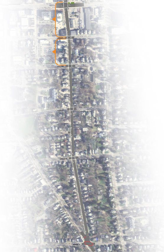
Public feedback guided the development of the alternatives, the        5. Evaluate public safety impacts, traffic operations,
evaluation criteria, and ultimately the selection of a preferred          driveway access, Marketplace garage circulation,
alternative.                                                              roadway dimensions, and VTrans approvals for a
                                                                          potential median in the downtown.
Process
                                                                    Shorter-Term Improvements (2020-2021)
The study evaluated existing conditions in the corridor to inform
what improvements the alternatives should include. An iterative     Northern Segment: Retain current vehicle pattern (two-way
alternative development process occurred over several Advisory      north of Union Street/Decatur Street and one-way southbound to
Committees and two Public Meetings. Extensive public                Pearl Street). Stripe on-street bicycle lanes in both directions
engagement through focused interviews, web surveys, in-person       between Pearl Street and Riverside Avenue. On-street vehicle
discussions, email, and meetings provided additional guidance.      parking on the east side would be removed between Pearl
                                                                    Street and North Street and between Union Street/Decatur
A preferred alternative emerged out of this process with a
                                                                    Street and Riverside Avenue. Implement the mini-roundabouts.
timeline and an implementation roadmap.
                                                                    Downtown Segment: Restripe the roadway for one southbound
Preferred Alternative                                               vehicle lane, one northbound vehicle lane, a center turning lane,
                                                                    northbound and southbound bicycle lanes, and protection for
Interim Improvements (2020)
                                                                    pedestrians and bicyclists, when possible.
   1. A comprehensive Parking Management Plan (PMP) is
                                                                    Southern Segment: Incorporate continuous bicycle lanes in
      recommended to identify strategies for managing parking
                                                                    both directions and remove east-side parking between King
      in the Pearl Street to Riverside Avenue study area. No
                                                                    Street and Main Street.
      changes to on-street parking will be made until
      agreement on the outcomes of the PMP.                         Corridor-wide: Improve high-priority transit stops and
                                                                    pedestrian crossings.
   2. Improve bicycle wayfinding between the southbound
      Winooski Avenue bicycle lane and the northbound Union         Longer-Term Improvements (Beyond 2021)
      Street bicycle lane.
                                                                    Modify roadway for two-way traffic for all modes north of Pearl
   3. Advance pilot projects or demonstrations to test mini-        Street, protected bicycle lanes where feasible, underground
      roundabouts on North Winooski Avenue.                         utilities, incorporate stormwater management, improve transit
   4. Address commercial loading and driveway queueing on           stops, add street trees, benches and other pedestrian amenities,
      Winooski Avenue in the downtown.                              and incorporate additional on-street parking wherever possible.

                                                                                                                                 v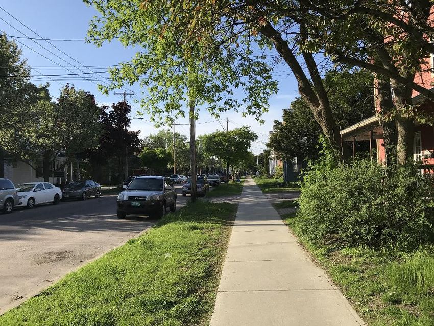
FIGURE 1: STUDY AREA
1.0 INTRODUCTION

The Winooski Avenue Transportation Study is a transportation
corridor study of Winooski Avenue. The study supports the City
of Burlington’s efforts to create multimodal Complete Streets
routes throughout the city.
As shown in Figure 1, Winooski Avenue stretches nearly two
miles from Riverside Avenue in the Old North End to the
Howard Street and St. Paul Street intersection in the South End.
The corridor serves as the principal north-south connection
through the heart of the City. It provides both access and
mobility for residents, employees, visitors, and business users.
This study follows an earlier technical analysis of Winooski
Avenue and Union Street that provided understanding of the
vehicular traffic operational implications of five alternative traffic
reconfigurations.1 Of the five reconfigurations analyzed,
Complete Streets improvements that maintain two-way vehicle
travel while better serving all modes on Winooski Avenue would
be the least disruptive to existing vehicle traffic in the downtown
study area.
What is this study?
This study is a comprehensive transportation study of the entire          “Complete Streets are corridors that provide
Winooski Avenue corridor. The study supports multimodal                   safe, inviting, and convenient travel for all
improvement strategies that address safety, capacity, and                 users of all ages and abilities —including
connectivity.                                                             motorists, pedestrians, bicyclists, and public
                                                                          transportation riders.”
                                                                          City of Burlington Public Works Complete Streets

1Winooski Avenue Circulation Study. June 2017.                           content/uploads/2017/07/Winooski-Avenue-Circulation-Study-Final-
https://studiesandreports.ccrpcvt.org/wp-                                Report.pdf

                                                                                                                                       1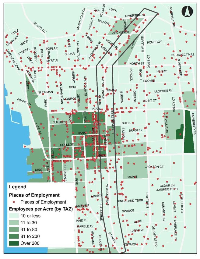
Why are we studying Winooski Avenue? Design Winooski Avenue as a self-enforcing 25-mph
street. (planBTV Walk Bike page 74)
Winooski Avenue is an important and heavily used corridor that
features diverse land uses. Despite its importance, a Study alternatives and make recommendations to
comprehensive corridor study has not yet been conducted. improve safety at the seven priority intersections along
Winooski Avenue identified in planBTV Walk Bike.
Although the corridor functions as a geographic gateway to the
(planBTV Walk Bike page 76-79)
City, it does not feel that way. Its multimodal facilities are
inconsistent and not intuitive to use. This study also seeks to evaluate Winooski Avenue’s
relationship with parallel streets and the street network as a
Moreover, 7 of the 20 priority intersections identified in planBTV
whole. It undertakes such an evaluation in terms of integration
Walk Bike are along Winooski Avenue. And 16% of bicycle
of transportation modes, connectivity, capacity, and safety. The
crashes and 17% of pedestrian crashes in the City in the past
goal is to develop alternatives that support improvement to
five years were along Winooski Avenue. Six VTrans High Crash
these elements to the extent possible.
Locations (HCLs) also occur along the corridor—four
intersections and two segments.
1.3 CORRIDOR VISION
Earlier transportation plans identified that reconnecting Pine
Street and St. Paul, both currently in design, would create The Project Advisory Committee (PAC) identified this vision for
additional opportunities for changes to Winooski Avenue. the corridor based on input from the community:
In addition, planBTV Walk Bike called for protected bicycle Traveling along and across Winooski Avenue will be
lane(s) the entire length of the corridor in its five-year action safe, inviting, and convenient for people of all ages
plan. Despite planBTV’s recommendation, a course of action and abilities using any mode of transportation.
and a holistic understanding of how to approach that concept Walking and bicycling will be viable and enjoyable
have not yet been investigated. ways to travel this corridor. Improvements will encourage
active travel and alternatives to personal vehicle use.
1.2 STUDY OUTCOMES
Businesses along and near Winooski Avenue will
This study seeks to identify how Winooski Avenue can become flourish with an activated streetscape and convenient
a Complete Street, providing “safe, inviting, and convenient access.
travel for all users of all ages and abilities.” (Burlington
The mobility and parking needs will be balanced for
Complete Streets Guidance)
property owners, residents, businesses, and the greater
Study the feasibility of and implementation options for transportation system.
low-stress bicycle facilities along the entire corridor in the
The street can adapt to changes to the transportation
long-term. (planBTV Walk Bike page 82)
system and land use.
2The City of Burlington’s planBTV Walk Bike Master Plan is an FIGURE 2: BURLINGTON'S MODE SHARE—PAST, PRESENT,
AND FUTURE GOAL
instrumental document that has set a bold and visionary mode
share target for the City. Changing travel behavior is
challenging and requires significant effort sustained over time.
The planBTV Walk Bike Master Plan includes several actions
that would bring about this change. Winooski Avenue is a focal
point of these actions. To that end, Burlington has made
significant investments in walking and bicycling infrastructure
since 2000 with results evident in the following documented
changes in mode share, see Figure 2.
In 2000, car modes were nearly 75%, walking nearly
17%, bus riding nearly 4%, and bicycling just over 1%.
As of 2013, car modes were approximately 64%, bus
riding at 5.2%, and active modes at 25%.
The future combined mode share goals in 2026 for
bicycling, walking, and bus riding are nearly double those
reported in 2000.
To help the City meet its stated mode share goals, the Winooski
Avenue Transportation Study must identify the challenges and
find solutions to encourage more trips to be made by non-car
modes.
Source: planBTV Walk Bike
31.4 INTEGRATION OF MODES Land-use site development polices can support transit,
walking, and bicycling and encourage shared auto use.
Integration of modes was identified as a goal in both the
planBTV Walk Bike Master Plan and the Regional Active 1.5 PROJECT GOVERNANCE
Transportation Plan. The following points identify practical
applications and meanings behind this concept: The City of Burlington (City) and the Chittenden Regional
Planning Commission (CCRPC) managed the project with the
Safety for one mode supports safety for all modes.
support from the consultant team. These entities formed the
Intersections are where all modes meet and cross each project steering committee.
other.
A Project Advisory Committee (PAC) was comprised of
Higher vehicle volumes negatively affect comfort and representatives of many organizations, businesses, non-profits,
safety of other users, namely pedestrians and bicyclists. local neighborhood associations, and other stakeholders
identified by the steering committee. See Section 4.2 for
A good transit system needs good pedestrian
additional information on the PAC.
infrastructure. Beyond accessible sidewalks in good
condition, this means lighting, shelters, and benches. The PAC provided input at key junctures and provided a
communication conduit (two-way) with the community. Figure 3
Bikeshare and carshare locations near transit support a
depicts the project team’s structure.
systematic option to driving. Placing bus stops,
bikeshare hubs, and carshare hubs close to each other FIGURE 3: PROJECT TEAM STRUCTURE
allows each mode to support the use of other modes.
Bicycling and vehicles benefit from quality pavement
conditions. Both modes have safety risks associated
with ruts, poor lane markings, and insufficient drainage.
Using the public right-of-way for access and enjoyment
of adjacent land is often at odds with using the space to
facilitate through traffic. Integration of modes builds a
platform for discussing and identifying solutions.
Certain types of on-street parking spaces could be
shared with each other. One example is sharing loading
zones with ride-hailing drop-off/pick up since these uses
occur at different times of day.
42.0 LITERATURE REVIEW Conclusions: The Complete Streets reconfiguration was found
to have the least impact on surrounding traffic and allow for two-
way bicycle facilities along the entire corridor. It involves
Over the past two decades, segments and intersections of keeping vehicle directionality the same, converting the four-lane
Winooski Avenue have been examined as part of stand-alone segment between Pearl Street and Main Street to three lanes (a
studies and included in larger plans. Relevant studies and plans northbound lane, southbound lane, and center turn lane), and
informed this transportation study, incorporating findings from removing parking in some corridor segments.
past analyses and ensuring consistency with guidelines set forth
by public agencies. N. Winooski Avenue & Archibald Street Intersection:
Pedestrian Safety and Mobility Evaluation
2.1 STUDIES CCRPC, 2011
Four studies of intersections or segments along Winooski Description: A technical study of pedestrian improvements at
Avenue are summarized below. this skew intersection in the Old North End.
Winooski-Howard-St. Paul Intersection Scoping Study Conclusions: Five options were offered, with the conclusion
that all were viable. Corner radii reduction (Option E) was
City of Burlington, 2018
recommended for further exploration since it provided a cost-
Description: Study of alternatives to improve bicycle and effective solution without creating significant vehicular or
pedestrian mobility and safety at this five-way intersection in the maintenance restrictions. These improvements have been
South End. implemented, including pedestrian push buttons and accessible
Conclusions: The final recommendation was to construct a crosswalks.
new signal system with pedestrian push buttons, an accessible South Winooski Avenue Lane Reduction
crosswalk of South Winooski Avenue, and curb extensions. In
the short term, do a semi permanent quick-build project, and in CCRPC, 2002
the medium term, construct an accessible pedestrian crossing Description: Studied a four- to three-lane conversion between
of South Winooski Avenue. Main Street and Pearl Street.
Winooski Avenue Circulation Study Technical Assessment Conclusions: The study concluded that the conversion would
work well and reduce crashes between College and Pearl
CCRPC, 2017
Streets. Between College Street and Main Street, lane reduction
Description: This is the technical assessment of five traffic was not recommended; study found it would significantly
circulation reconfigurations for Winooski Avenue (and increase delays unless the green signal time was changed,
consequently Union Street). It used three performance which may then impact east-west travel on Main Street.
measures: delay, level of service, and queue length.
5Downtown One-Way to Two-Way Conversion Memo NextGen Transit Plan
City of Burlington, 2000 GMT
Description: Traffic model and operational study identifying Description: This plan provided a comprehensive analysis that
hourly flow changes for converting one-way streets to two-way. revised the fixed route bus service that GMT provides within its
Discussed pros and cons of one-way versus two-way streets. service area.
Study focused on South Winooski and South Union.
Relevant Guidance and Sections: Three service improvement
Conclusions: The study concluded that the two-way scenarios have been developed for GMT’s local routes serving
conversion would work reasonably well. Largest change in Chittenden County. All scenarios include a mix of revised route
vehicle delay would occur at Union/Main Street intersection. alignments and schedule changes.
South Winooski would see overall flows increase with a Major themes guiding the scenario development:
northbound option introduced. Street widths limit opportunity to
Simplified service.
provide two-way vehicle flow, on-street parking, and bicycle
lanes. Core network of major local routes.
More evening service.
2.2 PLANS Better weekend service.
Various public agencies have put forth plans relevant to Minimum service frequencies.
Winooski Avenue in recent years, including the City of
One-seat ride between Downtown Burlington and the
Burlington, Green Mountain Transit, the Chittenden County Airport.
Regional Planning Commission, and VTrans. These plans are
summarized below. planBTV Walk Bike
Great Streets Downtown Standards City of Burlington, 2017
City of Burlington, Draft Status Description: The planBTV Walk Bike Master Plan identifies
walking and bicycling infrastructure issues and priorities in
Description: A set of standards to support Burlington’s vision of Burlington. It identifies opportunities from pilot projects to long-
having a vibrant, walkable, and sustainable downtown. term visions.
Relevant Guidance and Sections: Great Streets standards Relevant Guidance and Sections: Many sections of this plan
apply to downtown, which is defined as a 6 x 6 block grid are relevant to Winooski Avenue. They are identified by section
bounded by Pearl, Maple, Battery, and Union streets. Chapter 2 and page number below.
includes existing conditions and design considerations of
downtown streets, and Chapter 3 recommends street types of Engineering Action Plan (pages 67-72).
each street segment. Slow Zone Priorities (page 74).
6 Priority intersections for safety upgrades (pages 76-79). Description: A planning effort to categorize state roads into
high, moderate, and low use/priority corridors based on current
Proposed long-term network (page 82).
and potential bicycle use.
Priority Action List for Sub-Area 2 (page 106).
Relevant Guidance and Sections: The entire Winooski
Project lists for years 2-5 in Sub-Area 2 (page 108) and Avenue corridor is listed as a High Use/High Priority route.
Sub-Area 3 (page 131) (and following pages for details).
Downtown Parking and Transportation Management Plan
Improvement Concepts (North Winooski Avenue
Protected Bike Lane Concepts on pages 117-118, South City of Burlington, 2015
Winooski Avenue Bikeway Concept on page 121, and Description: A parking management plan for downtown with
South Winooski Avenue + Bank Street Intersection parking occupancies, observations, and management
Upgrade Concepts on pages 122-124). proposals.
Vision Zero elements (pages 140-144). Relevant Guidance and Sections:
Winter Cycling Action Plan (pages 145-148). Future land-use and parking demands.
Bicycle Parking Action Plan (pages 150-152). Recommendations based on summary of existing
demand and supply. (See Section 3: Future Demand)
Regional Active Transportation Plan
Recommendations for future governance and
CCRPC, 2017 management of parking data, collection, and analysis
Description: Supports the regional ECOS Plan and was (See Section 5: Parking and Transportation
developed in coordination with other concurrent local, regional, Management District)
and state planning efforts. Includes a series of proposed planBTV Downtown & Waterfront
infrastructure and non-infrastructure recommendations
organized around the five E’s–education, encouragement, City of Burlington, 2013
enforcement, engineering, and evaluation. Description: A comprehensive land-use and development plan
Relevant Guidance and Sections: See page 1 for important focused on Burlington’s Downtown and Waterfront.
points and issues identified during the development of this plan.
Relevant Guidance and Sections:
Winooski Avenue is identified as a High Priority corridor in the
“Provide an integrated transportation system” was #3 of
Proposed Regional Active Transportation Network. (page 2)
the Top 5 List of priorities the public wanted in this plan.
VTrans On-Road Bicycle Plan Phase 1 (page 43, “Burlington Values”)
VTrans, 2016 Notes that “the streetscape created by the private realm
is as important as any of the elements or provisions
7found in a conventional complete street package.” (page
68, “Themes in Detail”)
Connections through the former Town Center Mall were
identified to reconnect Pine Street and St. Paul Street to
repair the street grid and provide relief to Battery Street
and South Winooski Street. (pages 110-111)
No specific section of the plan dedicated to Winooski
Avenue.
Transportation Plan for the City of Burlington: Moving
Forward Together
City of Burlington, 2011
Description: The initiation of a ‘living vision’ for transportation in
the City. Creates a multimodal perspective and starts to define
priorities for specific facilities—setting up Complete Streets,
Great Streets, and modal-focused streets.
Relevant Guidance and Sections:
Street types within the City (Figure 2, page 7). Winooski
Avenue between Pearl and Main Streets is specified as
a Complete Street. North and south of this, Winooski
Avenue is classified as a bicycle street.
Complete Street design guidance (page 8).
Defines indicators of progress toward goals of the plan
(page 11).
83.0 EXISTING CONDITIONS Ultimately, land use is the fundamental input when determining
the character and role of a corridor. The future alternatives must
consider that tension and balance competing needs.
3.1 LAND USE FIGURE 4: CITY ZONING DISTRICTS
Winooski Avenue is one of the few north-south streets within the
City of Burlington. The variety and location of land uses along
the corridor make it unique. The corridor has mixed-use and
residential land uses along its length, with the mixed-use
segment between Pearl Street and Main Street part of
Burlington’s downtown core.
The corridor comprises four general zones:
Far north: neighborhood mixed use (commercial and
residential). Downtown
Core
North: residential (medium and high density).
Central: mixed use (downtown core).
South: residential (medium density).
Figure 4 depicts Burlington’s zoning districts.
The corridor serves two primary functions. It provides regional
access to the core of the City, and it also provides local access
for the residential and various commercial land uses located
along the corridor.
These competing uses create tension. Such tension is common
along transportation corridors that require both mobility and
access within the same space. This tension manifests in
competition for space among shorter- and longer-distance
travelers and in the need for localized parking or placemaking.
Source: City of Burlington Planning and Zoning
9Housing and Employment FIGURE 5: HOUSING DENSITY AND LOCATIONS (2015)
Determining the character of the Winooski Corridor requires
understanding its current uses, including for housing and
employment. To this end, analyzing housing and employment
can reveal patterns and relationships at the root of travel
demand. For instance, proximity between housing and
employment can support walking, bicycling, and other active
modes and indicate areas of parking demand.
Figure 5 depicts the housing and employment data by density in
each transportation analysis zone (TAZ) used in the CCRPC’s
regional traffic model (the model is not used in this study, but it
is used).2 The residential zones along the corridor—north of
Pearl Street and south of Main Street—are consistent with the
rest of the City, with an average density of up to 16 households
per acre.
Source: CCRPC and RSG
2The CCRPC Regional Travel Demand Model is not used in this extensively in Chittenden County and Burlington to forecast traffic
study. However, it as been used in the Phase 1 study and is used demands.
10The employment density (Figure 6) is close to an inverse of the The curb cut density (Figure 7) demonstrates a correlation
household density, with the downtown core providing most of between density and the number of curb cuts. This information
the employment. is particularly important when considering on-street parking,
types of bicycle facilities, and number of conflict points along
FIGURE 6: EMPLOYMENT DENSITY AND LOCATIONS
lengths of the corridor.
FIGURE 7: CURB CUT (DRIVEWAY) DENSITY
Data Source: CCRPC Regional Model
Source: RSG
113.2 MULTIMODAL another may cause additional confusion, which may lead to
INFRASTRUCTURE unexpected turning movements and crashes.
The following subsections dive into the primary modes used
Four corridors serve the primary north-south movement through
along Winooski Avenue—walking, bicycling, driving, and riding
Burlington:
transit—and how the corridor is and is not currently meeting the
Battery Street/St. Paul Street/North Champlain Street. needs of these modes and user groups.
Winooski Avenue. FIGURE 8: CROSS-SECTION OVERVIEW
Willard Street.
Prospect Street.
Aside from Winooski Avenue, these corridors provide two-way
mobility for vehicles and pedestrians along their lengths. None
of these corridors provide bicycle facilities along their entire
lengths.
Winooski Avenue’s pavement width3
On-street parking is
is 29 feet south of King Street and 36 inextricably linked to
to 43 feet north of King Street. It has multimodal infrastructure
six distinct cross sections, as shown and connectivity due to
in Figure 8, with differences in the the space it consumes in
presence, type, and directionality of the public right-of-way,
and safety issues such
travel lanes, bicycle facilities, and on- as “dooring” that can
street parking. Sidewalks are on both occur when car doors
sides of the street (outside of the are opened as a bicyclist
paved width), but all other cross- is passing. Parking is
section elements are inconsistent. discussed in Section 3.4.
The inconsistency of travel lanes and
bicycle facilities may make bicycling
less desirable and both modes more confusing and less
efficient. At intersections, changes from one cross section to Source: RSG
3 Pavement width is the distance between curbs, including parking and
travel lanes; it excludes sidewalks and green belts.
12Walking FIGURE 9: WIDE SIDEWALK WITH STREET TREES OUTSIDE
CITY MARKET, ADJACENT TO FOUR LANES OF TRAFFIC ON
Walking is a fundamental mode of transportation, and ensuring WINOOSKI AVENUE
that safe and accessible pedestrian facilities are present
throughout the corridor is essential.
Winooski Avenue has continuous and consistent sidewalks
along the length of the corridor. The standard five-foot wide
sidewalk (Figure 9) is the predominate facility type, with a
handful of locations having slightly wider facilities.
Throughout most of the corridor, the sidewalks are buffered
from travel lanes by a green belt at least five feet wide (Figure
10). No green belt exists between Pearl Street and Main Street
except on the east side north of Bank Street, though some
areas along this stretch have street trees in the sidewalk.
Generally, areas with wider sidewalks do not have a green belt;
one positive aspect is exchanged for another due to space
Source: RSG
constraints.
FIGURE 10: TYPICAL SIDEWALK ALONG WINOOSKI AVENUE
All signalized intersections in the study corridor, except for the OUTSIDE OF THE DOWNTOWN CORE
southern terminus at Howard Street, have pedestrian push
buttons and a walk phase. Some signals in the downtown core
(Pearl Street to Main Street) have the pedestrian walk phase
called during every signal phase (“recall”) regardless of whether
a person pushes the button or not.
Source: RSG
13Pedestrian Volumes volumes as the day progresses, with peaks at commuting
times and lunch time.
Pedestrian volume data are available from turning-movement
counts at major intersections along Winooski Avenue (Figure Main Street has a clear peak volume at midday and has
11). the highest total daily volume of these five intersections.
FIGURE 11: HOURLY PEDESTRIAN VOLUMES AT MAJOR Sidewalk areas along Winooski Avenue exhibit signs of high
INTERSECTIONS demand and inadequate facilities, such as areas with trampled
grass right next to the sidewalk. This was observed in several
locations along the corridor (Figure 12).
FIGURE 12: INADEQUATE SIDEWALK WIDTH ON WINOOSKI
AVENUE (LEFT: NORTH OF PEARL STREET, LOOKING SOUTH;
RIGHT: NORTH WINOOSKI AVENUE)
Source: CCRPC and RSG
Figure 11 depicts how different locations along Winooski
Avenue have different pedestrian demands, both in overall
volume and by time of day.
The Howard Street intersection in the mostly residential Source: RSG
South End has a relatively steady pedestrian volume and
lower pedestrian volume relative to the other Rating Pedestrian Facilities
intersections along the corridor.
Factors that affect the experience of people using pedestrian
The North Street intersection has midrange volumes that infrastructure include demand (number of users), the width of
follow school travel times. the facilities, surface conditions, the distance and type of buffer
The Pearl Street and Riverside Avenue intersections between pedestrian facilities and the roadway, the comfort and
(both in mixed-use areas) have increasing pedestrian exposure of adjacent land uses, and the speed and volume of
14adjacent vehicular traffic. At intersections, accessible curb cuts, FIGURE 13: EXISTING PEDESTRIAN QUALITY OF SERVICE
ALONG WINOOSKI AVENUE
tactile ramps, and signal phasing are basic infrastructure that
should be present throughout the corridor.
A pedestrian quality of service rating study was created to
reflect criteria important to the City of Burlington. The pedestrian
quality of service is shown in Figure 13. The quality of service is
a function of the physical elements rather than the number of
pedestrians (e.g., density of users) given the scarcity of
pedestrian count data.
Metrics used in the proposed pedestrian quality-of-service
system include the following:
Ratio of buffer width (including green belt, bicycle lanes,
and parking lanes) and number of travel lanes.
Buffer type (e.g., green belt, concrete).
Street tree density.
Percentage of block immediately adjacent to large
parking lot.
Sidewalk width lacking (generalizes that the entire
segment between Main and Pearl Streets should be five
feet wider).
Longest curb cut.
Source: RSG
15Bicycling Bicycle facilities along Winooski Avenue include:
Bicycling is gaining popularity as a form of transportation, and Shared-lane markings
not just recreation, around the country and in Burlington. For (“sharrows”) between
many people, it is a primary way to move around town, whether Riverside Avenue and Union
due to its affordability, its convenience, or its health, social, or Street/Decatur Street.
environmental benefits. A wide southbound bicycle
Why are walking and bicycling important for lane between Union
Burlington? Street/Decatur Street and
Excerpt from planBTV Pearl Street.
“First, people care about it! Even with limited No bicycle infrastructure between Pearl Street and Maple
infrastructure and no comprehensive plan in Street.
place, census data shows that more Burlington
residents are getting to work by bicycle or on Northbound (contra-flow) and southbound bicycle lanes
foot. Second, safer walking and bicycling between Maple Street and Howard Street.
conditions will improve the quality of life for
everyone. A growing body of data from around Rating Bicycle Facilities
the country documents that growth in walking
The primary factors that make a roadway better or worse for
and bicycling brings a host of environmental and
economic benefits tied to reduced traffic bicycling include the bicycle facility type and the roadway
congestion, reduced vehicle emissions, lower context. Roadways are “rated” for bicycling according to the
road maintenance costs, savings in healthcare level of stress bicyclists may experience based on these
costs, increased independence for those who factors.
can't drive, and more.”
Winooski Avenue is a desirable corridor to ride a bicycle. It is a
primary north-south corridor through Burlington that links
neighborhoods and provides access to many businesses,
homes, and services. It also has relatively flat terrain. However,
the inconsistency of bicycle facilities, segments, and driveways
with high volumes of vehicles, and challenging intersections,
may result in people avoiding bicycling or feeling unsafe
bicycling along parts of the corridor.
16Factors that affect the stress level of bicyclists can include the attention than might be expected from children. Except in
following: low speed/low volume traffic situations, cyclists have their
own place to ride that keeps
Vehicle traffic speed and volume.
them from having to interact In a region that
Heavy vehicle (truck) volumes. with traffic except at formal experiences snow and
Separation of bicycle facilities from vehicular traffic—by crossings. Physical separation freezing weather in
distance or a physical buffer. from higher speed and winter, pavement
multilane traffic. Crossings condition and striping
Presence of on-street parking.
that are easy for an adult to condition—both of
Driveway density. negotiate. which experience
Pavement condition. LTS 3: More traffic stress than seasonal wear and
LTS 2, yet markedly less than tear—are particularly
For example, a roadway with high motor vehicle speeds and
the stress of integrating with important factors.
volumes would be a high-stress roadway to a bicyclist, while a
multilane traffic, and therefore
quiet residential street would be low stress. On the quiet
welcome to many people currently riding bikes in
residential street, there may be no need for bicycle facilities, but
American cities. Crossings may be longer or across
on the more heavily trafficked street, unprotected or protected
higher-speed roads than allowed by LTS 2, but are still
bicycle lanes may be necessary to reach a low-stress
considered acceptably safe to most adult pedestrians.
environment for bicyclists.
LTS 4: A level of stress beyond LTS3. Involves
Bicycle Level of Traffic Stress (LTS)4 is one method used to
interaction with higher speed traffic or close proximity to
“rate” bicycle facilities based on roadway context. The following
high-speed traffic. (Note: not applicable to Winooski
are descriptions of each of the four traffic stress levels:
Avenue.)
LTS 1: Presenting little traffic stress and demanding little
The LTS system has a series of tables that can be used to
attention from cyclists, and attractive enough for a
determine the appropriate LTS for a given roadway segment.
relaxing bicycle ride. Suitable for almost all cyclists,
These evaluation criteria consider the number of travel lanes,
including children trained to safely cross intersections.
bicycle lane width (or sum of bicycle lane width and parking lane
Strong separation from all except low speed, low volume
width if next to a parking lane), prevailing speed, and amount of
traffic. Simple crossings.
bicycle lane blockage (such as high parking turnover).
LTS 2: Presenting little traffic stress and therefore
suitable to most adult cyclists but demanding more
4Mineta Transportation Institute. 2012. “Low-Stress Bicycling and http://transweb.sjsu.edu/sites/default/files/1005-low-stress-bicycling-
Network Connectivity,” network-connectivity.pdf.
17Using these criteria tables alone, the LTS for segments along *An AADT of 5,000 vehicles per day may be an appropriate
Winooski Avenue ranges from LTS 1 to LTS 3. This finding threshold between lower-volume streets and higher-volume
does not intuitively match the LTS descriptions above. This streets.
mismatch may stem from several factors:
FIGURE 14: BICYCLE LEVEL OF TRAFFIC STRESS USING CITY
Winooski Avenue meets the system’s low-speed CRITERIA
threshold with a speed limit of 25 mph (which vehicles
largely conform to—see Section 3.3 of this report).
However, relative to the rest of the City, 25 mph is
typical and may still feel fast to some bicyclists,
especially considering other factors such as traffic
volume and number of driveways.
The LTS tables use number of lanes rather than vehicle
volume as a way to make the ratings accessible without
volume data. This can oversimplify the ratings.
Separate tables are used to define LTS at intersections.
As a result, a segment with higher-stress intersections
throughout would not have a higher LTS to reflect that.
Winooski Avenue has several high-stress intersections.
To better match the intention of the LTS ratings in a way
that fits in the context of Burlington, the City has developed
a draft set of criteria for rating level of stress:
LTS 1: Bicycle paths, protected bicycle lanes, and
greenways.
High-Stress Intersections
LTS 2: Bicycle lanes and buffered bicycle lanes on lower-
volume streets.*
LTS 3: Bicycle lanes and buffered bicycle lanes on
higher-volume streets* or shared lane markings.
LTS 4: No designated bicycle facilities or markings on
higher-volume streets.*
Source: RSG and City of Burlington
18Although on-road northbound bicycling is not permitted between Pearl Street
and Decatur Street, many people cycle northbound, either “salmoning” in the
southbound bicycle lane or against traffic in the travel lane.
Bikesharing
Bikesharing is an innovative transportation program, ideal for
short-distance, point-to-point trips. Hub-based bikesharing
offers users the ability to pick up a bicycle at any self-serve
bicycle station and return it to any other bicycle station located
within the system’s service area. Users can access the system
through low-cost subscriptions ranging from a few dollars for
one day use to annual memberships.
Greenride Bikeshare launched in Burlington, Winooski, and
Greenride Bikeshare hub at 237 North Winooski Avenue
South Burlington in April 2018 with the first phase of a multiyear
rollout. The Greenride system is currently a hub-based FIGURE 15: GREENRIDE BIKESHARE HUBS IN BURLINGTON
bikeshare model, requiring users to end their trip at a hub or pay (PHASE 1)
an additional $5 fee when locked away from a hub. Greenride
will eventually provide a high level of coverage throughout
Burlington and adjacent communities. Phase 1 deployed 17
hubs. Phases 2 and 3 will introduce another 20-25 hubs and
increased flexibility of virtual hubs, an additional 100 bikes, and
a replacement to an all e-bike fleet.
One hub is located along the study corridor at 237 North
Winooski Avenue, a building with 28 apartments and a yoga
studio. Another two hubs are located nearby on Church Street.
A map of existing Greenride hubs in Burlington is shown in
Figure 15.
19Driving FIGURE 16: TRAVEL PATTERNS OF VEHICLES ACCESSING
WINOOSKI AVENUE
In recent years, the proportion of people using different modes
of transportation has shifted. The result of this shift has been a
reduction in driving, though it remains the predominant mode
choice. In addition, many people who use other forms of
transportation also occasionally drive. Most of the right-of-way
along Winooski Avenue is designated for vehicles, whether in
the form of travel lanes or parking.
Vehicle Volumes
Winooski Avenue is an important driving route to and through
the core of Burlington. Figure 16 shows that the majority of the
corridor’s traffic enters and exits Burlington via Riverside
Avenue, Pearl Street, and Main Street. Union Street is an
important parallel street due to its function with Winooski
Avenue as a one-way travel pair.
Along Winooski Avenue, the highest traffic volumes occur within
the four-lane section between Pearl Street and Main Street, with
an average annual daily traffic around 11,000 vehicles (Figure
17).
Source: CCRPC Regional Traffic Model
This map is based on a ‘select link’ analysis. The volumes shown only include
vehicles that drive on Winooski Avenue as part of their trips.
20You can also read