Manchester City Council Contaminated Land Strategy - Updated March 2011 Contaminated Land Section
←
→
Page content transcription
If your browser does not render page correctly, please read the page content below

Manchester City Council

Contaminated Land Strategy

      Updated March 2011

          Undertaken by
    Contaminated Land Section
     Environmental Services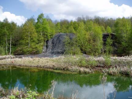
CONTENTS                       Page
                                                     Number

Introduction                                                 1
Context                                                      2
Legislation and national policies                            2
Corporate Objectives                                         3
The Contaminated Land Strategy                               4
Our Achievements                                             5
Managing our information efficiently                         5
Identifying land that may be contaminated                    6
Action taken under Part 2A legislation                       7
Contributing to the Council’s strategic priorities           7
Consultation and partnership working                         8
Our Future Commitments                                   10
Assessment of landfill sites                             10
Review processes                                         10
Conclusion                                               11
Contact details                                          11

APPENDIX I
APPENDIX II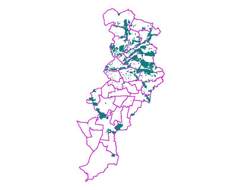
Introduction

Manchester and the surrounding towns were the centre of the Industrial
Revolution in England. The City has seen intense industrial activity in many
places from the 19th century to the present day. The City’s modern
commercial and economic importance owes much to this industrial past.

Industrial activity in cities such as Manchester has of course had a significant
impact on the local environment. In particular it has left a legacy of potentially
contaminated land at former industrial sites and at infilled mineral
excavations. In some cases significant risks from this contamination now
have to be addressed to protect the health of all those who live and work in
the City and to prevent damage to the environment.

    Manchester’s former industrial land provides great opportunities for the
    City.

    Such land is a major resource for:

    x regenerating and developing existing communities

    x meeting the demand for new housing using ‘brownfield’ land, thus
       preserving the nation’s treasured countryside

    x developing new sustainable urban communities

In November 2001 Manchester City Council published its Contaminated Land
Strategy. The Strategy stated how the Council was:

   x tackling the legacy of contamination on former industrial land

   x encouraging the best use of this large urban land resource.

This current report provides a review of the progress that has been made to
implement the Contaminated Land Strategy and sets out our commitments for
continuing this work.

                                         1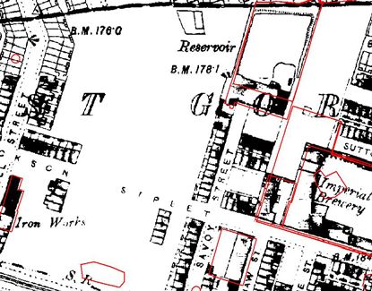
Context

Legislation and national policies

Awareness of the problems associated with land contamination has increased
greatly in recent years. The demand for more housing has put pressure on
land resources and highlighted the need to use brownfield land effectively.
The importance of contaminated land as a national issue is reflected in
primary legislation and associated regulations and guidance:

    x Part 2A of the Environmental Protection Act 1990: Providing a
       new regime for dealing with the problems arising from contaminated
       land.

    x Contaminated Land (England) Regulations 2000 (SI 2000:227):
       Deals with the procedural matters, including the content and service
       of remediation notices and the appeals process.

    x DEFRA Circular 01/2006 ‘Contaminated Land’: Statutory
       Guidance that supports The Act and sets out the UK Government
       Policy on contaminated land.

The legislation, commonly referred to as ‘Part 2A’, came into effect in April
2000. It sets out the new regime for identifying and remediating serious
contamination. It provides a definition of contaminated land (Appendix I) and
provides local authorities and the Environment Agency with a consistent
framework for tackling problem sites.

Every local authority in England and Wales has a duty to inspect their district
for potentially contaminated land in a ‘rational, ordered and efficient’ manner.
Ideally such land will be remediated voluntarily by those who caused the
problem or, according to the legislation, is the ‘appropriate person’. However,
in some cases local authorities or the Environment Agency will have to use
their regulatory powers to enforce remediation.

                                       2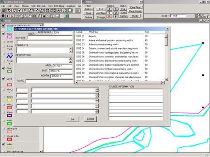
Corporate Objectives

Manchester City Council is continuing to develop Manchester as a city of
national and international importance.         Effective management of our
brownfield land is contributing to several key Corporate Objectives:

    Key Corporate Objectives

         x Environment: to develop and sustain a healthy, safe and
            attractive local environment which contributes to the City’s and its
            people’s economic and social well-being.

         x Health: to prevent ill-health and improve local people’s health
            and well being.

         x Population: to increase the numbers of people living in the City
            and to reduce the turnover of people leaving the City by creating
            successful communities

Opening up land for new uses and tackling derelict sites in the City also
contributes indirectly to other Corporate Objectives by increasing economic
activity, creating jobs, stimulating growth, and reducing crime and anti-social
behaviour.

                                      3
The Contaminated Land Strategy
Our Contaminated Land Strategy is the basis for the sound management of
our brownfield land resource. It underpins the work needed to deal with land
contamination and contributes to fulfilling the Council’s wider Objectives.
Aims of the Contaminated Land Strategy:
x To improve the quality of life for Manchester people in line with
the Manchester Improvement Programme
x To protect people from risks to health
x To protect the land and water environment
x To support the regeneration of the City
x To encourage the re-use of previously developed land
We will achieve these aims by:
x Ensuring that Manchester City Council fulfils its new duties
under Part 2A in particular:
x to inspect the district to identify potentially contaminated
land
x to investigate land to determine the extent of any
contamination problems
x to bring about the remediation of contaminated land
x to encourage voluntary remediation wherever possible
x Working towards consistency in managing land contamination
across all relevant Council services
x Working in partnership with the Environment Agency and other
stakeholders
4Our Achievements
The Council is committed to delivering its Contaminated Land Strategy and
have allocated additional resources to strengthen our specialist Contaminated
Land Section within Environmental Health. The Contaminated Land Section:
y provides a customer-oriented service for developers, consultants and
members of the public
y provides a consultancy for planning applications on contaminated land
and supervises the investigation and remediation of new developments
y acts as the central point within the Council for information on ground
contamination
y acts as an internal technical consultancy for the Council and advises
on best practice
y carries out environmental information searches
Managing our information efficiently
A Geographical Information System (GIS) and a database are being used to
manage the large amount of information being acquired. They enable us to
store all of the data in a single secure system that it is fully validated and
provides a facility that gives immediate access to the history of sites, maps
and photographs of its current use and links to the information contained
within the Sections records including any action that has been taken to
manage contamination problems. Digital historical maps have been
purchased to allow the history of land within the district to be traced. The
current use of land is assessed using both current Ordnance Survey mapping
and recent digital aerial photography.
Digital historical mapping allows the Recent aerial photography is used in
history of land to be traced. conjunction with Ordnance Survey
mapping to determine the current use of
the land.
5Identifying land that may be contaminated
A systematic procedure has been developed to identify potentially
contaminated sites and assess the possible risks. Historical maps are first
reviewed to trace former industrial uses. The sites are then ranked according
to the potential for the industries to have contaminated the land, taking into
account the sensitivity of the current use.
The prioritisation system currently being used in Manchester for the purposes
of Part 2A complies with national statutory guidance, and was developed for
use by all the Greater Manchester Authorities. The system is known as the
PG01 Risk Prioritisation Methodology (PG01) and can be found described in
Appendix II.
Recording the boundaries of historical Entering data to obtain a risk score.
industrial sites.
Using the PG01 method, over 6500 potentially contaminated sites have been
identified in the City.
The initial identification and prioritisation of sites (Phase 1) is an informed
estimate of the potential for contamination to be present at a site and the
possibility that it may pose a risk to health or the environment.
Phase 2 of the strategy has now begun. This consists of carrying out detailed
inspections of the 6500 sites, in order of priority, to identify whether
contamination is actually present.
6Action Taken under Part 2A legislation
Some contaminated land has already been investigated, and remediated
where necessary, under Part 2A. These have included:
x Garden soils at a housing estate in East Manchester were found to
contain unacceptable levels of heavy metals. The affected gardens
were remediated and a copy of the Remediation Statement can be
found in the contaminated land public register.
x A site investigation has been completed at a former tip site in
Harpurhey which is next to the River Irk. The information will be used to
design a scheme to remediate the land and begin to create a new high
quality open space.
x A site investigation is almost complete at another former tip site in
North Manchester which is adjacent to a college.
Open land in Harpurhey used historically as a tip for industrial wastes.
Contributing to the Council’s strategic priorities
The Contaminated Land Section has carried out detailed environmental desk
studies to support large scale voluntary transfer of housing stock in the south
and east of the city. This is part of the strategic transfer of all council-owned
housing to registered social landlords and other management organisations.
An overview study has been completed to identify the parts of the district with
the greatest concentrations of historical industry. These are the areas likely to
have become the most polluted. This overview will assist strategic planning
while the detailed prioritisation of potential contaminated sites is being
completed.
7Areas of the City with the greatest concentrations of historical industry and
landfilling.
Consultation and partnership working
Ensuring best practice is adopted for new development
The new contaminated land regime is designed to deal with contamination
problems that cannot be addressed under other legislation such as the
planning system. Given the extensive redevelopment of land now taking
place across the City, it is particularly important that any contamination
problems at new development sites are identified straight away and not left for
the future. To help facilitate this, a guide has been produced for developers
and consultants, which explains how planning controls are used, and sets out
the Council’s standards for remediation when any problems are found. This
will ensure that land is properly assessed before any development work
starts, and that a high standard of remediation is implemented in any new
schemes. The guide is now available to all prospective developers within the
City.
Achieving successful remediation of contaminated land
Consultation with local residents and other stakeholders has been a priority
during the investigation and remediation of Manchester’s first Part 2A land.
This has been achieved using public meetings and drop-in sessions,
undertaking house-to-house visits, and by ensuring that information is made
readily available. A high level of cooperation has been achieved between
Council departments including Planning, Environmental Health, Building
Control and also developers and consultants. This has provided confidence
8to those affected by the contamination and ensured the smooth running of the
remediation works.
Working with other local authorities in the region
Contaminated Land Officers across the Greater Manchester area continue to
meet regularly through the Land and Water Working Group of the Greater
Manchester Public Protection Managers’ Group (formerly MAPAC). This
forum allows the exchange of technical experience and best practice. Officers
are working together towards greater consistency in managing contaminated
land across the region.
9Our Future Commitments
The actions identified for the implementation of the Contaminated Land
Strategy are:
y to continue to respond to the Council’s strategic management priorities
y to progress the detailed inspection and remediation of sites identified
as potentially contaminated, in order of priority
y to assess the potential risks at each of our landfill sites
y to continually review progress to ensure that the Council’s objectives
and strategic priorities are being fulfilled.
Listed below are some specific examples of how these commitments will be
met.
Assessment of landfill sites
The Council has 62 officially designated landfill sites within its area, many of
which were filled before record keeping of such activities was undertaken.
Consequently relatively little information is held regarding what went into the
sites. The information we do hold is under review and some of the sites will
be inspected in order to establish the condition and extent of the landfill. This
work will ensure that reliable and consistent information is provided to other
Council departments, developers, and landowners. It will also identify at an
early stage any landfill sites requiring remediation.
Review processes
The review schedule for this document is 2 years unless circumstances
dictate otherwise. A review of the Statutory Guidance is taking place during
2010-11 and, following any changes to that regulatory document, the
Council’s Strategy will be updated where necessary.
10Conclusion
The Contaminated Land Strategy is being taken forward as part of the
Council’s continuing commitment to develop Manchester as a City of national
and international importance, with a thriving economy and a healthy
environment. The Contaminated Land Section in Environmental Health has
been expanded, and much progress has been made since the Strategy was
published in 2001. In particular, a large proportion of the land has already
been reviewed to identify land that may be contaminated. This resulted in the
first site found to be contaminated land being successfully remediated.
We have an ongoing programme of work focused on the Council’s Corporate
Objectives for health, the environment, and the Council’s statutory
responsibilities under Part 2A. Our work will continue with detailed site
inspections for those potentially contaminated sites that have been identified
under the prioritisation process. Our priority remains to protect the health of
those living and working in the City.
Contact details
The Contaminated Land Section
Environmental Protection Group
Regulatory & Enforcement Services
Neighbourhood Services
Manchester City Council
1 Hammerstone Road
Gorton
Manchester M18 8EQ
Telephone: 0161 234 1363
Fax: 0161 274 7245
e-mail: envhealth@manchester.gov.uk
11Appendix I Definition of Contaminated Land Under Part IIA
Section 78A defines contaminated land for the purposes of the new regime in
the following way:
“Contaminated land” is any land which appears to the local authority in whose
area it is situated to be in such a condition, by reason of substances in, on or
under the land, that-
(a) significant land is being caused or there is a significant possibility of
such harm being caused; or
(b) pollution of controlled waters is being, or is likely to be caused.
The term ‘significant harm’ refers to harm to certain specified ‘receptors’ –
human beings, ecological systems and property – as set out in Table A of Part
3 of the statutory guidance. The phrase ‘significant possibility of significant
harm’ must be interpreted with reference to Table B of Part 3 of the statutory
guidance.
For the purposes of Part IIA, the term ‘controlled waters’ has the same
meaning as in Section 104 of Part III of the Water Resources Act 1991, and
includes territorial and coastal waters, inland fresh waters, and ground waters.
The phrase ‘the pollution of controlled waters’ refers to (Section 78A(9)) the
entry ‘of any poisonous, noxious or polluting matter or any solid waste matter’.
For land to be designated as contaminated land for this reason, the pollution
must be continuing, or it must be considered likely that pollution might occur.
It should be noted that the term 'ground water' is used here to refer to all
water contained in the ground, whether in the unsaturated or the saturated
zone - that is, including water above and below the water table. The term
'groundwater', as a single word, is used in the Groundwater Regulations [11]
in relation to the protection of water bodies which are potential sources of
supply, and refers only to water in the saturated zone - that is, below the
water table. Care must be taken when using either term in the context of Part
IIA.
The new definition of 'statutory' contaminated land places the emphasis on
whether or not conditions are present that may give rise to unacceptable risks
to human health or the pollution of controlled waters. It does not depend
solely on the presence of undesirable substances in the ground, and makes
no distinction between man-made and naturally occurring contaminants.
Even if land contains potentially hazardous substances, as long as the
substances cannot harm human beings or pollute controlled waters, the land
will not be classified as contaminated land. An example of this is a modern
landfill site, which is properly lined and secured, and where there are no links
between the fill materials and the outside world.Appendix II PG01 risk prioritisation methodology The primary regulatory role under Part IIA rests with local authorities. In order to fulfil this role in a manner which ensures that the most pressing and serious problems are considered first MCC has adopted a risk prioritisation system that identifies high risk sites for early investigation. The risk prioritisation system currently being used in Manchester for the purposes of Part IIA complies with national statutory guidance, and was developed for use by all the Greater Manchester Authorities. The system is known as the PG01 Risk Prioritisation Methodology (PG01). Manchester City Council has made minor changes to the Land Use Classification codes which are used in the model. This ensures that they are representative of the types of historical land uses present within Manchester. A list of revised classifications is included at the end of the Risk Prioritisation Methodology document.
You can also read