MILITARY EXERCISE "WALLABY 2019" SHOALWATER BAY/ROCKHAMPTON 24 SEPTEMBER TO 7 NOVEMBER 2019 - Airservices Australia
←
→
Page content transcription
If your browser does not render page correctly, please read the page content below
AUSTRALIA                                        AIP SUPPLEMENT
      AERONAUTICAL INFORMATION SERVICE                            (SUP)
            AIRSERVICES AUSTRALIA
        GPO BOX 367, CANBERRA ACT 2601

                     CONTENT
       Email: adf.airspace@defence.gov.au
       Phone: 02 6128 4857/4858
                                                               H78/19
                      DISTRIBUTION
       Email: aim.editorial@airservicesaustralia.com   Effective: 201909231600 UTC

      MILITARY EXERCISE “WALLABY 2019”
       SHOALWATER BAY/ROCKHAMPTON
      24 SEPTEMBER TO 7 NOVEMBER 2019
1.     INTRODUCTION
1.1    Military exercises code-named “Wallaby 2019” will be conducted in the
       Shoalwater Bay Training Area (SWBTA) from 24 September – 7 November
       2019 inclusive.
1.2    Significant deployment and redeployment of personnel and equipment will
       take place both before and after the actual exercise period.
1.3    Exercise aircraft, including C130 transport and military helicopters (AH64,
       AS332 and CH47) will operate from Rockhampton aerodrome and within the
       exercise area. Minor delays to civil aircraft may be experienced.
1.4    The major exercise activities will be conducted within the SWBTA, north of
       Rockhampton, as listed in Section 2 below.
1.5    Live Firing of high explosive weapons from ground based and airborne
       platforms, on ranges throughout the entire SWBTA, will take place throughout
       the exercise. Mainland ranges and ranges on Clinton Peninsular and
       Townshend Island will be active for live firing activities.
(SUP H78/19) Page 2 of 6
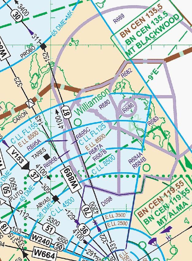
2. AIRSPACE - SHOALWATER BAY/ROCKHAMPTON
2.1 The following Shoalwater Bay Restricted areas will be activated by NOTAM:
IDENT VERTICAL LIMITS
R680 Akens Island NOTAM - NOTAM
R682 Townshend Isalnd NOTAM – NOTAM
R683 Cape Clinton NOTAM – NOTAM
R684B Mount Hummock 2000 – NOTAM
R687B Raspberry Creek 2000 – NOTAM
R689 Shoalwater Bay NOTAM – NOTAM
R695B Herbert Creek 2000 – 6000
R695C Herbert Creek 6000 – NOTAM
2.2 Restricted areas R684A, R687A, and R695A, permanently active H24, will
be utilised for the exercise.
2.3 The expected maximum altitude (LUL for non-exercise aircraft) for activation
of SWBTA Restricted areas is FL300. Exercise aircraft will not operate above
FL280. Changes will be promulgated by NOTAM.
2.4 D698 will be activated to facilitate military transit between Rockhampton and
Shoalwater Bay.
2.5 Mustering Operations. Requests for mustering operations are to be emailed
to rod.whannell@defence.gov.au by the aircraft operator at least 48 hours
prior to the planned activity. Approved mustering activities will be provided
the protection of a Sensitive Area (SA), surface to 2,500 FT AGL which
military aircraft will avoid. For further information contact ADFLO AirOps
on 0477 320 629.
2.6 The following information is to be provided by the aircraft operator:
a) Operating area:
• Station name
• Radius (nominally 1-2NM) of operation from a centre point
provided as a LAT/LONG
b) Period:
• Dates
• Times (e.g. first light until last light)Page 3 of 6 (SUP H78/19)
c) Aircraft:
• Type
• Callsign
• Visual markings
• SSR code - 1200 Mode 3C
• Communications - monitoring CTAF FREQ and/or Area broadcast
FREQ
d) Contact information:
• Name
• Phone number(s)
2.7 Clearances for Non-Exercise Aircraft
2.7.1 During exercise execution, an ADFLO is appointed to manage the
exercise airspace. Pilots seeking access must contact the ADFLO
Air Operations on 0477 320 629.
2.7.2 Clearance shall be issued to Customs/Coastwatch aircraft on
priority tasks, irrespective of the status of the airspace involved,
such that these flights are subject to the minimum possible delay.
2.7.3 Every endeavour will be made to adjust exercise activities and
minimise delays to facilitate transit of exercise areas by civil aircraft
engaged in SAR, Mercy flights, emergency and MEDEVAC or
HOSP Status operations.
2.7.4 Access to the exercise area for other operators may be available at
limited times throughout the exercise. A minimum of 24 hours prior
notice is required.
Note: When access is available, a proforma detailing timings and associated
procedures for the access will be emailed or faxed to the operator requesting
access and must be returned prior to entry approval.
3. MILITARY AIRCRAFT OPERATIONS
3.1 C130 aircraft and helicopters will operate day and night, low-level (below
5,000 FT AMSL) and use Night Vision Goggles (Refer ERSA GEN – FIS –
Night Vision Devices and Equipment).(SUP H78/19) Page 4 of 6
3.2 Military C130 aircraft operations outside D698 and the SWBTA Restricted
Areas will be conducted via flight planned routes, with prior coordination
where possible.
3.3 Military aircraft will attempt to avoid known “sensitive” areas and areas of
high-density tourist aviation activity.
3.4 Traffic information on military aircraft operating in D698 will not be available
and, therefore, will not be passed to military or civil aircraft.
3.5 Military aircraft are equipped with enhanced detection equipment and are
able to co-ordinate and share information on any traffic detected. The visibility
from the cockpit of the C130 and helicopters is excellent and crews place the
utmost priority on see and avoid in conjunction with detection technology.
To further enhance detection and avoidance capability, civil aircraft are
encouraged to use their transponder (if equipped) as well as switching on
external strobes and landing / taxi lights.
3.6 Military aircraft may use a Laser Flare instead of normal flares to signal in
an emergency recovery. This laser flare is similar to a laser pointer except
that it has a broad light beam to enable airborne aircraft to see it. The Laser
Flare is eye safe.
4. ROUTE FLIGHT PLANNING REQUIREMENTS DURING
THE HOURS OF ACTIVATION OF SHOALWATER BAY
RESTRICTED AREAS.
4.1 Standard routes may not be available during the activation of Shoalwater
Bay Restricted areas due to exercise requirements. In particular the following
routes will be affected:
4.1.1 Y32 - Aircraft that would normally plan Y32 below the Shoalwater
Bay NOTAM Height shall plan via the following waypoints:
HM – 214200S 150500E – 215600S 1510900E – ROWAN
4.1.2 Q26 within the Shoalwater Bay area - Aircraft that would normally
plan via Q26 below the Shoalwater Bay NOTAM height shall plan
via the following routes:
• Landing TL, plan CORAL – RK – TARES – MK – ALISN – TL
• Landing PN, plan CORAL – RK – TARES –WELKE - MK – PN
• Landing CS, plan CORAL – RK – TARES –IDUNA – HM – AS PER ERSA
• Landing HM, plan CORAL – RK – TARES – IDUNA – HM
• Landing MK, plan CORAL – RK – TARES – WELKE – MKPage 5 of 6 (SUP H78/19)
4.2 Other aircraft operating between MK and RK, whose normal route would
infringe the Shoalwater Bay Restricted areas below the NOTAM height shall
plan via MURPH southbound and RK – TARES northbound. Aircraft landing
MK from the south shall plan via RK – TARES – WELKE – MK.
4.3 When tracking visually clear of Shoalwater Bay Restricted areas, tracking
Rockhampton to Marlborough via the Bruce Highway, thence direct Mackay
and vice versa will keep aircraft clear of the areas.
4.4 The above information is not exhaustive and further queries should be
directed to the Brisbane Operations Room Manager on +61 7 3866 3224.
5. PREFLIGHT INFORMATION
5.1 Significant aviation-related activities will be promulgated by NOTAM and
pilots should obtain relevant information prior to operating in the exercise
areas.
5.2 Promulgation of NOTAM information can be subject to delay. Aircraft
intending to operate in the areas must check the status of the airspace prior
to entry.
5.3 The status of exercise airspace, Shoalwater Bay permanently promulgated
areas and the exercise temporary special use airspace can be accessed
via the NAIPS Internet Service or via the Canberra Briefing Office on
1800 805 150.
5.4 NAIPS Internet Service – Location Briefing
a) For FIR NOTAM use the codes of 7400 and 7440.
b) For Shoalwater Bay Restricted areas use code SBX.
c) Specific aerodrome weather and NOTAM may be requested by entering
the required location codes.
5.5 NAIPS Internet Service – Area Briefing (Select from the Chart graphic or
Area and Sub Area Directory)
a) For weather and NOTAM (including FIR, Temporary Danger Areas and
SBX) use the codes of 9400 and 9440.
b) Be advised the use of ‘Area Briefing’ will provide you weather and
NOTAM on ALL aerodromes within the selected areas.(SUP H78/19) Page 6 of 6
6. ROCKHAMPTON AIRPORT – AVAILABILITY AND
STATUS
6.1 Taxiway and Apron limitations. Taxiways A, C, G, H, L and northern end of
main RPT Apron may not be available due to military operations. Closures
will be notified by NOTAM.
6.2 CH47 Wake Turbulence. CH47 are classed as “Heavy” for wake turbulance
calculations. Extreme care must be exercised in the vicinity of these aircraft.
7. HOLDING FUEL REQUIREMENTS
7.1 Aircraft operating into Rockhampton may be subject to delays during the
exercise period. Potential delays of 30 minutes or more will be advised by a
Traffic Fuel Advisory NOTAM.
8. START APPROVALS
8.1 Aircraft departing Rockhampton may require start approval. Any requirement
for Start approval will be notified via the Rockhampton ATIS.
9. CANCELLATION
9.1 Unless modified by NOTAM this SUP self-cancels at 201911071400 UTC.
10. DISTRIBUTION
10.1 By Airservices Australia website only.
Appendix
1. Shoalwater Bay Training Area and D698Appendix 1 TO
(SUP H78/19)
1. Shoalwater Bay Training Area and D698You can also read