Placenames, Gone but not Forgotten - Mountain Stewards
←
→
Page content transcription
If your browser does not render page correctly, please read the page content below
Placenames, Gone but not Forgotten
                                  By Don & Diane Wells

Burnt Mt. Community Becomes a Place

Have you been to Johntown, Dougherty, Pots Mountain or Yellow Creek in Dawson
County; Alice, Sweden, McDaniel, or Harnageville in Pickens County? These are some
of the placename towns on Georgia maps from 1855 to 1915. None of them exist today.
You would have to research old, old maps to find their locations. Many of these towns
got there beginning after the removal of the Cherokees from North Georgia.

Congress passed the Indian Removal Act in 1830 by one vote and Georgia acted quickly
to begin the removal process. Surveyors were hired to survey the Cherokee Nation in
North GA and divided it into four sections, then districts and finally into 160 acre land
lots and 40 acre gold lots. The 1832 GA Land Lottery gave away the Cherokee lands to
deserving Georgia citizens. Few ever occupied the land they were given since the
Cherokees didn’t leave immediately.

In 1840 a town later named Burnt Mountain began to develop in the Pickens County
mountain area. Much like other communities in the Southern Appalachian Mountains,
some of its people moved south from North and South Carolina. Many were of Scotch-
Irish decent. Self-sufficient farmers, they grew what they needed and traded what they
did not need for staples such as sugar, salt, and tobacco.

The families of John Dilbeck and Isaac Burlison were some of the earliest settlers in
Burnt Mountain. Records show that John Dilbeck was 53 years old when he arrived in
1840. He and his family had come from Spartanburg, SC in an ox-drawn wagon. His two
brothers came with them but they did not settle on Burnt Mountain. After seventeen
years, John died in 1857.

In 1840, at the age of twenty-four, Isaac Burlison, his wife Hannah and their three
children arrived. To say they were a hardy family would be an understatement. The
roads and old Indian trails from North and South Carolina to the new lands in North
Georgia that existed at that time were notoriously rutted and difficult. Putting all of their
possessions in a two-wheeled cart, and leading a cow and a bull, the Burlisons made their
way to Burnt Mountain. Imagine the difficulty of making a trip like that especially with
three children. Hopping into a car with comfortable seats, air conditioning, satellite radio
and movies to entertain the kids for a quick trip to Asheville just doesn’t compare!

The Burlison’s, Dilbert’s and other families that followed them were not recipients of the
Land Lottery property, so they would have had to buy the property or, if it were
abandoned, occupied it until it could be transferred to their name. (Need to check record
for Burlison LL 113, District 5). It is open to speculation as to how they found out about
this property located 3,000 feet up in the Southern Appalachian Mountains in an area few
had ever seen except the Cherokees.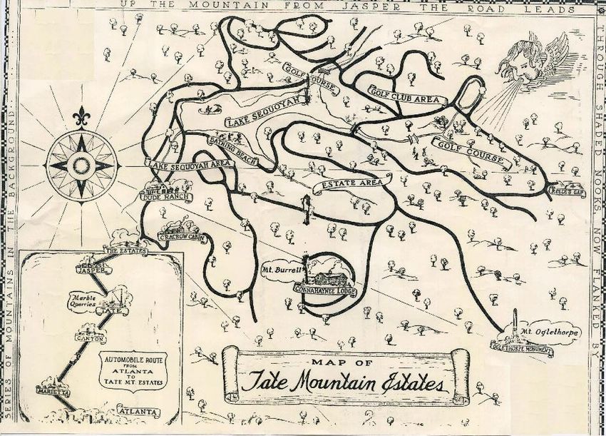
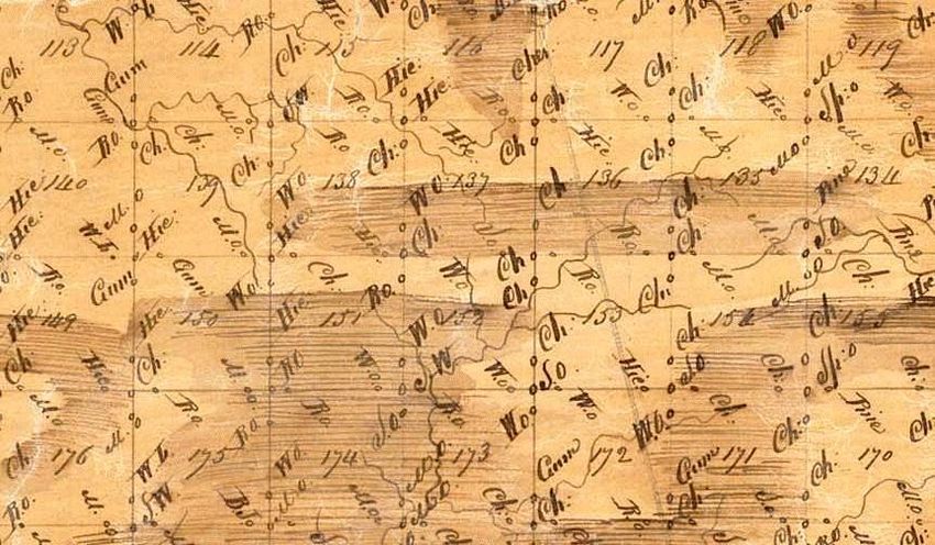
A small portion of the Land Lottery Map of Section 2, District 5 is shown in the picture.
LL 114 at the top of the map is where the town was located according to the 1903 J.W.
Henley Map of Pickens County. Note that the surveyor marked the streams but no roads
are shown. Perhaps there were some but the map doesn’t indicate any. The surveyors
marked the corners of the LL using trees. Note the many Chestnut (Ch) trees that were
used. Today due to the chestnut blight, they are all gone.

Family history
documents tell
us that the
Burlison’s cut
down            a
Chestnut tree
and built a
twelve-foot
pen. At one
end of the pen
was a fireplace
for     cooking
and heat. They
covered      the
exterior of the                  Section 2 District 5 Land Lottery Map
pen        with
leaves and other materials to stop wind and weather. Surely they had a roof but no data
exists about it.

In the pen they built a "Georgia bed." One of its posts was nailed to a corner post of the
pen. The bed was closed in with wooden slats. Grass, leaves and hay were pushed in
between the slates in order to provide some insulation. They survived a year in that pen
until they could clear land and build a cabin.

Isaac and Hannah were frugal. They saved their money and soon had enough to start
buying up more land on the mountain. At one point, Isaac and Hannah owned most of
what is now the Tate Mountain Estates on Rt. 136. Isaac built a sawmill and a gristmill
on Clear Creek. As time went on, he became the banker and bondsman for the Burnt
Mountain community and was considered the de facto Mayor. Around 1860 Isaac gave
the land, materials and labor to build the Burnt Mountain Baptist Church and the
community school. There is still a small white church near where they were located on
what is now Lake Sequoyah. Isaac was a deacon of the church for over ten years.

In the 1860’s a post office was opened in the Burnt Mt. Community and that probably
signified the beginning of the town although it did not appear as a placename on a map
until 1883. Throughout the Civil War, Isaac, a member of the Confederacy, served as
Postmaster of Burnt Mountain. As with many families in these mountains the war was
truly brother against brother or father against son and several of Isaac’s sons served in the
Union Army. Isaac died on March 5, 1885 at the age of 69. Hannah lived another 14
years. Both Isaac and Hannah are buried in the cemetery at Burnt Mountain Baptist
Church.

The Burrell's, another family who were early settlers in Georgia came to America from
England. Joseph McDuffy Burrell was born in Union County February 9, 1851. He and
his family later moved to the area of Ebenezer Baptist Church in Gilmer County. On
February 16, 1870, Joseph became a part of Burnt Mountain history when he married
Martha Jane Burlison. Isaac and Hannah gave their daughter and her new husband 80
acres of land near the top of Burnt Mountain as a wedding gift. Josephs' brother,
Grandville Alexander, known as G.A., also moved to Burnt Mountain and became his
brother’s neighbor.

        Placenames, Gone But not Forgotten – Part 2
                                  By Don & Diane Wells
Burnt Mountain: From a Thriving Mountain Town to Gone
By the end of the Civil War, the Burnt Mt. Community was a thriving but somewhat
isolated mountain community. Now with a church, a school, a grist mill and a post office,
they were self sufficient with little need to head down into the flat lands except for
staples. The population continued to grow to the point that by 1880, the census for Burnt
Mt. was about equal to that of Jasper, GA, which was the county seat. Linda Geiger’s
Pickens County Census Index for 1880 provides a record of those living on the mountain
in the Sharptop District of Pickens County.

Very little is known about the school on Burnt Mt. other than it is believed to have met in
the Burnt Mt. Baptist Church building. A reference from the Pickens Herald dated 28
February 1889, stated that: “Mr. B.J. Chester of Dawson County was hired to teach the
public school at Burnt Mt. during the 1889 term and that a large school (of children) was
expected for that year.”

The Burnt Mt. Baptist Church was the center of life in the community. They sometimes
joined with the Ebenezer Baptist Church Community located down the mountain to the
north in Gilmer County. The records show that a number of the children of members of
these two early communities married and some moved to Burnt Mt. The Rev. John
Graves Holbert was probably the first preacher at the church. Licensed to preach in 1859
and ordained on July 26, 1862 when he was 34 years old, he was a member of the church
for 48 years. He died on December 20, 1884 and is buried at the church.

The Rev. Sam Hammontree (1870-1930) was probably the next minister at Burnt
Mountain. Sam was a circuit riding preacher and supported all the small churches in the
area. From the 1940’s to the 1960’s, the Rev. Howard Babe Reece (1911-1964) was the
preacher at Burnt Mountain. He is also buried at the church.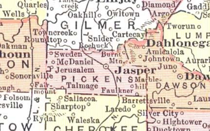
Most of the people living in the community were farmers. Making a living farming on the
mountain at 3,000 ft in elevation was a hard life. The soil, covering solid rock, was thin
and the     growing season, from May to October, was relatively short. Not all were
farmers. Joseph Burrell, Isaac’s son-in-law, replaced Isaac as Postmaster. Driving a horse
and buggy, he delivered the mail on the mountain. In the winter time, he would place a
heated rock in the buggy to keep his feet warm. All along the mail route, his customers
would have replacement heated rocks for him to use.

The peak of Burnt Mountain is sometimes shown on old maps as Burrell Mountain or
Burrell Top since both Joseph and his brother Grandville Burrell lived there. The Burnt
Mountain name is thought to have come from the fact that the Indians often burnt the
mountain top in order to clear the underbrush so that they could gather the chestnuts, a
valuable commodity.

While Burnt Mountain was mostly self sufficient, the residents had to make periodic trips
to Jasper and Ellijay to sell their produce, buy staples and transact business in the county
offices. The trip to town was not an easy one. The 1903 J. W. Henley Pickens County
map shows the old road that existed from Burnt Mountain to the valley. Present day
Route 136 to the top of Burnt Mountain was not built until the late 1920’s. The main road
to Jasper went through what is now the Burnt Mountain Preserve. It came out on Windy
Ridge Road and then followed Old Grandview Road to town. At a number of locations
along the old roadbed, stones can be found stacked off of the roadway probably by the
early users to make it more passable.

A book by the Forest sisters (Martha and Betty) called "The Mountains Surround Us,
Memories of a Georgia Family" published in 1994, sheds some light on the main road to
Jasper. Henry Forest (Martha and Betty's grandfather), who lived on Burnt Mountain for
a time in the early 1900's before moving down to the foothills of Grandview, wanted to
go to church at Burnt Mountain instead of attending Sharptop Baptist Church. Getting up
there in a wagon however was a long day's trip.

It is difficult to pick the year when the Burnt Mountain Community began to decline. In
all likelihood the decline began in the late 1880’s and accelerated thereafter. The railroad
arrived in Jasper in 1883. Prior to the railroad arriving, the cotton mills came to Talking
Rock and the marble industry to Tate. Jobs were increasing in the valley. It was an easier
living than hoeing dirt on the mountain. Also, land was being given away as new western
states were added to the union. The opportunities for a different lifestyle put a stain on
family ties. People packed up and moved. In the early 1910's, Joseph Burrell and possibly
his brother, sold off their land holdings to Sam Tate and moved to Alabama to raise
cotton.

The July 3, 1903 Pickens Progress reported that the Sharptop (includes Burnt Mountain)
and Griffith School Districts were consolidated. A building for the new school was built
near the residence of Mr. Quinton and W.T. Townsend. That school, the Mt. Olgethorpe
School, was located on Grandview Road south of Pendley Creek. The July 15, 1920
Pickens Progress reported a decline in population in the mountain communities from
1910 of over 55%. That dropped the total population to 147 persons throughout the NE
section of the county.

The 1910 Rand McNally map of GA still showed the town of Burnt Mountain but that
was the last time it appeared as a placename. By then farming life had all but ended for
this mountain community. With no school for the children and declining membership at
the church, the town withered away leaving only a few hardy souls remaining.

         1910 Rand McNally Map of Pickens County Showing Burnt Mt Community
Placenames, Gone but Not Forgotten – Part 3
By Don & Diane Wells
A New Burnt Mountain Community Arises
Having been an active, thriving community, the Burnt Mountain area became sparsely
populated as its citizen began to move away. Barely eking out a living, many of the
farmers who lived in the mountain community had little choice but to sell their land or
have it repossessed in a Sheriff’s sale after the government began taxing it. Col. Sam
Tate, the marble baron of Pickens County, his relations, and his enterprises took
advantage of these tax sales and began buying up the mountain in the late 1800's/early
1900's. For about twenty years after the Burnt Mountain Town placename was removed
from Pickens County maps, Sam Tate continued to purchase Land Lots on the mountain
range. In the Pickens County Deed Book, covering the period from 1854 to 1936, there
are pages and pages of the numerous Tate transactions. Hannah Burlison sold 160 acres
to William Tate in 1885. Martha Cowart sold 160 acres to Sam Tate in 1903. The
Burrell’s also sold their land to the Tate’s. Descendants of the early settlers continued to
sell their lands to the Tate’s during the construction of Tate Mountain Estates. Eventually
the Tate’s owned the entire mountain community which included Burnt Mountain,
Grassy Knob (now Oglethorpe Mountain), and Sassafras Mountain (once called
Moonshine Mountain).
In early 1928, Sam Tate announced a plan for a part of his land holdings near the old
Burnt Mountain Community. The headline article in the June 28, 1928 Pickens Progress
reads, "Large Company Forms to Develop Pickens Mountains - Ten Thousand Acres to
be turned into South's Greatest Playground." The new company, Tate Mountain Estates,
would develop the area of Grassy Knob, Sassafras and Burnt Mts. The new corporation,
of which Sam Tate was president, planned to build a modern hotel, an 18-hole golf
course, parks and an airplane landing field. The project would create "one of the prettiest
towns in the south."
It was reported in the Pickens Progress that Sam hired Mr. E. Burton Cooke, famous for
designing the Biltmore, home of the Vanderbilt’s, and the Warm Springs Georgia home
of Governor Roosevelt from New York, as the landscape architect for the Tate Mountain
Estates. Mr. Cooke’s original Tate Mountain Estates plan for the "prettiest town on a
mountain in the south" included Lake Sequoyah. Sam also hired noted golf course
architects Stiles & Van Kleek of Boston Massachusetts, who had done over 300 golf
courses across the nation, to design the Tate Estates golf course. Robert Trent Jones, the
famous golfer of that time, also had a hand in the design of the golf course.
A large number of small building lots would surround the golf course. South of the lake
and on the north side of Burnt Mountain an estate area with larger building lots was
planned. Beyond the estate lots was the Connahaynee Lodge located on the top of Burrell
Mountain. Burnt Mountain has two peaks. The lower peak to the east was referred to as
Burrell Top or Burrell Mountain and the western peak was referred to as Burnt Mountain.
Today, both peaks are called Burnt Mountain. To the west of the Connahaynee Lodge
was to be another hotel area on the Burnt Mountain peak surrounded by building lots, anobservatory and a horse stable. Below the lake dam was the Winnaretta Camp activities center and more home sites. The Winnaretta Camp was originally called the “Dude Ranch.” And finally, there was to be a community center located near where the main overlook is on Rt. 136 today. Initially the power on the mountain was supplied using “Delco Systems.” The Delco System was a gas generator that charged an array of batteries in bluish glass jars. These power systems could satisfy the needs of a single house but were less than adequate to power up the hotel and for supplying water. Sam Tate had connections with the Georgia Power Company and in the summer of 1933, GA Power installed power lines up the mountain for a single customer, Tate Mountain Estates. To support the water needs of the planned community, a major water piping system was planned. Initially, a 70,000 gallon concrete tank was built on a high knoll north of the lake and water was pumped from a spring near the Burnt Mountain Baptist Church to the tank. The water then flowed by gravity to homes. Water for the hotel had to be pumped up hill from another spring. The corporation initially issued 10,000 shares with a bond of $600,000. This was revised upward in March 1929 to 20,000 shares and a bond of approximately $1,000,000. Tate Mountain Estates may have been the most extensive and exciting plan for development east of the Mississippi at that time. The development plan included building roads to Burnt Mt. from Jasper, roads for the town community, golf course and lake area, roads to the top of Burnt Mountain for the hotels, and another new road (later called Monument Road) to Grassy Knob. Grassy Knob Mountain was renamed Oglethorpe Mountain in October 1930. The Oglethorpe Monument, commissioned by Sam Tate and built at the Tate Marble factory, was erected at the top of the mountain in the summer of 1930 but not dedicated until October 23, 1930. The monument has since been moved to the north end of Main Street in Jasper.
Work began on the Tate Mountain Estates during the week of July 5, 1928 according to
the Pickens Progress. The 51-acre Sequoyah Lake area and dam were completed in early
April 1930. They began filling the lake, supplied by Clear Creek, at that time. It has been
reported that as the lake began to be filled, it drove out the rattlesnakes from their hiding
places and over 250 of them were killed. The Connahaynee Lodge was first completed in
early 1930. A new wing was added to the lodge because of the large number of guests
coming and was completed in early September 1931.
Placenames, Gone but not Forgotten – Part 4
The New Burnt Mt. Town, Tate Mountain Estates, Declines like Its Predecessor
By Don & Diane Wells
Sam Tate's vision for Tate Mountain Estates was never realized. The planned year-round
resort town for the most part, operated in the summer months only. The building of the
summer houses around Sequoyah Lake began soon after the dam was finished but only a
few houses were initially built. The Connahaynee Lodge was finished in October 1930
and stayed open for only one year into the winter months.
Timing for the building of the Tate Mountain Estates could not have been worse. The
Depression hit in 1929 and lasted for several years. It wiped out or significantly reduced
many people’s available resources. For the most part, everyone "hunkered down" to await
better times. A summer home was not an option for most people. The March 9, 1933
Pickens Progress published a letter from Sam Tate urging “the public to stand together in
this national crisis." The nation was in a crisis and so was Sam Tate. He had spent a lot of
money on Tate Mountain Estates and it was not selling.
The people who did eventually buy into the Tate Mountain Estates were called “Taters.”
Collectively, they owned part of a unique mountain community that for the most part was
somewhat isolated from the fast-paced life of the urban world. People attracted to the
mountain communities today come there for the very same reasons. The Taters enjoyed a
leisurely life in the summer months fishing, swimming, horseback riding, playing golf,
hiking, playing cards, or just sitting on their porches in the cooler climate of the Southern
Appalachian Mountains. For the children, it was almost heaven as they could roam at
will, play organized games, or just enjoy the forested area. The road signs today in Tate
Mountain Estates still say, “Drive Slow, Free Range Children.” It was like a summer
camp without a lot of supervision.
The original plan for Tate Mountain Estates included a more rustic “Dude Ranch” for
some guests. The camp included the horse stables and an activities building used as a
gym, a place for dances, summer programs and more. The name of the Dude Ranch was
changed to Winnaretta, a Cherokee word meaning “tumbling waters”. Due to the hard
financial times during the start up of Tate Mountain Estates, the camp was leased out as a
summer camp for children from Atlanta. These “guests” of Tate Mountain Estates were
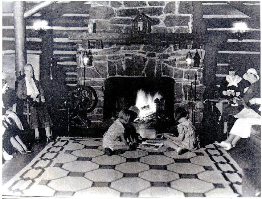
housed at the camp and shared the facilities with the “Taters.”The Connahaynee Lodge became the premier place for prominent people from Atlanta and across the southeast to come to on weekends or for vacations. Additionally, it was a celebrated place many national associations visited. The June 4, 1931 Pickens Progress reported that 250 editors from the National Editorial Association visited the Connahaynee Lodge on Wednesday of that week. They traveled in a motorcade led by the Atlanta Police force and Sam Tate. It was further reported that, "The Jasper Women's Club erected a booth on the road leading toward Tate Mountain Estates and the ladies served the visitors cold lemonade as they passed by." The Connahaynee Lodge was built in a “Y” shape and had two floors. Local chestnut trees, killed by the blight, were used to build the lodge along with stone quarried nearby. The main floor had a vaulted lounge with an enormous fireplace on the western side, a dining room and Connahaynee Lodge places for people to gather to play cards or have an enjoyable conversation while sitting in overstuffed leather chairs. On the second floor were thirty guest rooms with marble baths. After dinner on weekends, the chairs and tables of the dining room were pushed back to make a dance floor where the guests and the local Taters could dance the square dance to the tunes of a local band. Also, in the dining room were the slot machines where you could try your luck at gambling. Some of the Tater children, called “mountain children” by the guests would stop by the lodge and be given quarters to try their luck in the slots. The top of Burrell Mountain where the Guests Sitting Around Connahaynee Lodge Fireplace
lodge was situated was cleared of its trees. The guests could see in all directions. It was
claimed that you could see five states from the lodge. The lodge was a place where you
could buy cigarettes and beer. At the time, Pickens County was a dry county so the lodge
was a place to go get your liquor and smokes. Since “Moonshine Mountain” was nearby,
one could probably purchase a little “shine” also.

Six years after starting Tate Mountain Estates, Sam Tate filed for bankruptcy on 16
November 1934. The bankruptcy petition listed $363,000 in assets and $136,800 in
liabilities according to the November 29, 1934 Pickens Progress. Four months later, the
bankruptcy proceeding were stopped and a new entity know as Appalachian Realty
Company was formed consisting of some of the people who owned land in Tate
Mountain Estates as well as Sam Tate. They bought the corporation on 31 August 1935
and planned to spend a considerable sum of money developing the resort. However, in
December 1937, Sam Tate sold 6,109 acres of land on the mountain to his relatives for
$1,000 and by 1938, Sam Tate had died. The Connahaynee Lodge plus fifteen acres was
sold in 1940 for $16,500 to Joe Adams and his wife from Miami. The original cost of the
lodge was estimated to be $75,000.

By the early 1940’s with World War II starting, the financial conditions of the Tate
Mountain Estates had not improved and Appalachian Realty Company was bankrupt. The
entire Tate Mountain Estates property less the Lodge and the lots already owned were
sold at public outcry on the Pickens County Courthouse steps on August 1942. The
people who owned property in the community bought Tate Mountain Estates at the
foreclosure sale for a reported $10,000. They formed Tate Mountain Associates which
owns the property today.

The Connahaynee Lodge burned to the ground on March 1946 marking the end of Sam
Tate’s dream.

Starting in 1931, the Appalachian Trail began near the Oglethorpe Monument and
followed Monument Road and then crossed over Tate Mountain Estates to the north. By
1949 logging operations had destroyed the road and parts of the trail. The Appalachian
Trail Guide for that year stated that the road beyond the now destroyed Connehaynee
Lodge "is a little used dirt fire-road which at times was impassable by automobile." The
trail guide further stated that "all that remains of the once extensive Tate Mountain
Estates is a group of summer homes which are located around the lake. Rumor has it that
the “moonshiners” on the mountain often shot at the hikers as they went by so that the
start of the trail was eventually moved in 1959 to Springer Mountain leaving those who
had settled into the Tate Mountain Estates to enjoy their unique mountain in peace.
You can also read