THE SUMMIT IRISH HILLWALKERS' QUARTERLY, MAY 2020 - NEWS - INFORMATION - RECENT CONTRIBUTIONS - FEATURES - FORUMS - MOUNTAINVIEWS
←
→
Page content transcription
If your browser does not render page correctly, please read the page content below
Approaching Corraun from the east
b Brendan O’Reilly

                                                         OUNTAIN
                                                         I E W S

                                    THE SUMMIT
                              I r i s h Hi l lwa l k e r s ’ Q ua rt e r ly, m ay 2 0 2 0

          NEWS - INFORMATION - RECENT CONTRIBUTIONS - FEATURES - FORUMS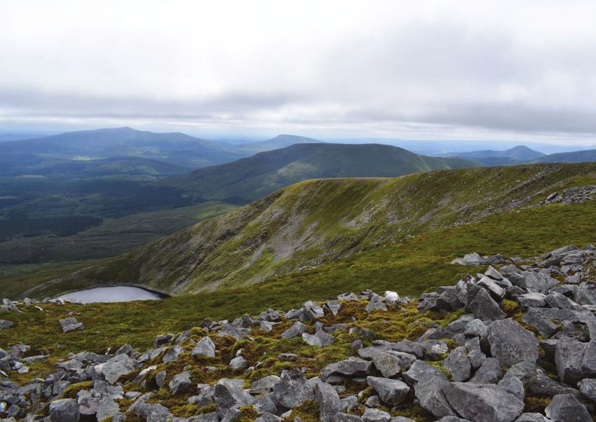
m o u n ta i n v i e w s n e w s

WELCOME TO OUR may QUARTERLY NEWSLETTER                                    in this issue...
                        At the time of writing there’s                     recent mountain comments                                    page 3
                        continuing uncertainty as to                       track of the month: the orkney islands                      page 4
                        when and what way we will                          recent members tracks                                       page 7
                        walking again.
                        One thing that may become                          summiteering: ban those binnions by david
                        relevant is that some                              murphy                                                      page 8
disciplines of hillwalking tend to lend themselves                         ADVENTURE: the lake district by motorbike by
to social distancing. Summiteering for example                             Bleck cra (douglas reid)                                   page 10
is usually a small group affair often to less well
                                                                           backpacking: wild nephin by ilenia venditti                page 12
known places. Arguably a challenge walk spreads
people out well though its organisation would                              hillwalking reading: the angry corrie fanzine              page 16
need to work at social distancing.                                         CHALLENGE: the toughest events by jim holmes               page 17
The problem may come with group social walking where people in different                                                              page 20
                                                                           lockdown fun
isolation bubbles would be prone to walk together.
                                                                           HISTORY: THE DJOUCE/WHITE HILL AIR CRASH, 1946             page 21
Enjoy our mix of articles from Pepé’s humour to
Ilenia Venditti inspiring our future with an                               photo of the month                                         page 26
account of backpacking in May. And there’s                                 editor’s photo pick                                        page 27
plenty more.                                                                                                                          page 29
                                                                           em-vee tube: the best video picks for may

Support the governments’ advice
and representative bodies positions.
MountainViews website and committee support the Irish and Northern
Irish government’s measures to stop the spread of Covid-19.

• Irish Government statement HERE     My request to all of you is to:
• Northern Irish Government           Stay at home
statement HERE                        Stay off the hills and mountains
• Mountaineering Ireland statement    Avoid travelling for exercise
HERE
                                      • Ulster Federation of Rambling
Murrough McDonagh, CEO                Clubs UFRC statement HERE
                                                                                                         Descent from Cumber Hill, Slieve Blooms
Mountaineering Ireland, states:                                                                                            b Brendan O’Reilly
Regions: MOUNTAIN COMMENTS | TRIP REPORTS | TRACKS | SUMMARIES

midlands                                                              northwest
                                                Isolated old                                                             A meander in the
                                                volcano with great                                                       Dartrys
                                                views                                                                    Ochils_trekker
                                                Croghan Hill in the                                                      took a snake-
                                                North Midlands                                                           like approach to
                                                is Ireland’s most                                                        Annacoona Top
                                                isolated mainland                                                        but was rewarded
                                                hill and has fine                                                        with great views of
                                                views across the                                                         Annacoona itself,
                                                boggy plains,                                                            Benwiskin and
                                   b Simon3
                                                reports Simon3.                                                          Donegal Bay and
                                                                                                    b ochils_trekker
                                                                                                                         Tievebaun in the
Link: https://mountainviews.ie/summit/1017/comment/5776/                                                                 distance.
                                                                      Link: https://mountainviews.ie/summit/282/comment/20777/

midlands                                                              west
                                              Blooming fine walk                                                       Last Pre-Corona peak
                                              The bluebells                                                            It has been 5
                                              supplied a magic                                                         long weeks since
                                              carpet for melohara                                                      magnumpig (and the
                                              during a stroll in                                                       rest of us!) enjoyed
                                              Capard Wood in the                                                       the freedom to
                                              Slieve Blooms.                                                           wander the hills of
                                              Link: https://                                                           North Mayo. But
                                              mountainviews.                                                           his final outing to
                                              ie/summit/505/                                                           Doonvinalla E left him
                                              comment/20776/                                                           with happy memories.
                                                                                                                       Link: https://
                                                                                                                       mountainviews.
                                                                                                                       ie/summit/5064/
                                b melohara                                                         b magnumpig
                                                                                                                       comment/20778/
Regions: MOUNTAIN COMMENTS | TRIP REPORTS | TRACKS | SUMMARIES

track of the month - the orkney islands
                                                                           View over Rackwick Bay from the path to
                                                                           the Old Man b Purple Peak Adventures

                                                                           Among the must-see sites on the bucket-list of virtually every
                                                                           traveller to Orkney, is the Old Man of Hoy, a 137-metre sea stack
                                                                           on the west coast of the island of Hoy. The interest of many visitors
                                                                           (like us) is no doubt piqued by their first glimpse of this iconic
a hoy, there...                                                            rock formation from the deck of the MV Hamnavoe ferry that sails
This month’s selection is from the most mountainous of the                 between Scrabster and Stromness.
Orkney Islands off the north coast of Scotland, and a visit (without           Comprised of layers of soft, sandy and pebbly sandstone, and
an actual ascent, which carries a climbing grade of E1!) to the            harder flagstones of Old Red Sandstone from the Devonian era
legendary pinnacle of The Old Man of Hoy, courtesy of mcrtchly and         (c390 ma), the Old Man rises from a plinth of basalt rock and is
kernowclimber. The Old Man is just one of many spectacular coastal         separated from the mainland by a 60-metre chasm strewn with
features hereabouts (see the featured photos), and if you undertake        debris. One of the tallest sea stacks in the United Kingdom, scurvy-
the logistical challenge of getting to Hoy in the first place you may as   grass, sea mayweed and sea campion cling to its vertical faces and
well continue a few miles north to St John’s Head, the highest vertical    nesting fulmars occupy its ledges.
sea cliff in the UK at 335m tall.                                              The Old Man is probably less than 250 years old, and will
Regions: MOUNTAIN COMMENTS | TRIP REPORTS | TRACKS | SUMMARIES

                                                                                The Old Man is popular with climbers, and was first scaled by
                                                                             mountaineers Chris Bonington, Rusty Baillie and Tom Patey in 1966.
                                                                             From 8–9 July 1967, an ascent featured in The Great Climb, a live
                                                                             BBC three-night outside broadcast, which received around 15 million
                                                                             viewers. This featured three pairs of climbers: Bonington and Patey
                                                                             repeated their original route, whilst two new lines were climbed by
                                                                             Joe Brown and Ian McNaught-Davis, and by Pete Crew and Dougal
                                                                             Haston. In 1998, Catherine Destivelle was the first person to make a
                                                                             solo ascent of it.
                                                                                To reach the stunning cliff point views of the Old Man entails
                                                                             a 9km-round trip from the starting point at the car park above
                                                                             Rackwick Bay. Allow around three hours. The route traverses very
                                                                             steep terrain on the west side of the bay along a road (serving a
                                                                             handful of cottages) via a couple of hairpin bends before it becomes
                                                                             a well-defined and well-maintained stony track which ascends
                                              The Old Man in the blue hour   diagonally towards the top of the cliffs across open moorland. The
                                                b Purple Peak Adventures
                                                                             route passes into The Old Man of Hoy RSPB Nature Reserve which
                                                                             offers sweeping views over Rackwick Bay and the Pentland Firth.
undoubtedly collapse in future. Winds hereabouts are faster than 8           The route then contours around the southern base of Moor Fea
metres per second for nearly a third of the time, and gales occur on         (304m), and the top of the Old Man eventually looms into view. We
average for 29 days of a year. Combined with the depth of the sea,           were amazed to sight numerous mountain hares resplendent in
which quickly falls to 60 metres, high-energy waves on the western           their white winter coats as we traversed the moorland below Moor
side of Hoy lead to rapid erosion of the coast.                              Fea, while the calls of water fowl drifted across the quiet moorland
    The Old Man is not mentioned in the Orkneyinga Saga (written             from the direction of the tiny Loch of Stourdale, a mere spoonful of
c.1230), and on the Blaeu map of 1600 a headland exists at the point         gloomy water atop the cliffs.
where the Old Man is now. The McKenzie Map of Hoy, dated 1750,                  The track leads straight to a very narrow promontory of rock
similarly shows a headland but no stack, but by 1819 the Old Man             which juts precariously out of the vertiginous cliff face almost
had been separated from the mainland. A contemporaneous sketch               opposite the Old Man at the Tuaks of the Boy. Here we carefully set
by William Daniell depicts the sea stack as a wider column than              up our cameras to capture some images of the Old Man as the sun
today, with a smaller top section and an arch at the base, giving it a       sank low on the western horizon which cast an alluring golden glow
human-like form, hence its name. Sometime in the early-nineteenth            over the old red sandstone. The cries of fulmars on barely visible
century, a storm washed away one of the ‘legs’ leaving it much as it         nearby cliff ledges, was incessant. In summer, this is a great spot for
is today, although erosion continues. By 1992 a 40-metre crack had           puffin watching.
appeared in the top of the south face, leaving a large overhanging              Almost as soon as we left the promontory (our anal nerves
section that will eventually collapse.                                       surprisingly intact!) for a photo spot further to the south, the wind
Regions: MOUNTAIN COMMENTS | TRIP REPORTS | TRACKS | SUMMARIES
picked up and began Mackay Brown called Rackwick ‘Orkney’s last enchantment’ and ‘the
to gust violently. It hidden valley of light’. The Burnmouth Bothy is an early-nineteenth
would have been century, single-storey, roughly rectangular-plan former crofthouse
next to impossible with a heather thatched roof; adjoining the northeast gable is a lower
to stand on the three-bay former byre with a flagstone roof. Burnmouth was used
promontory in such by the BBC in 1970 for an adaptation one of McKay Brown’s stories,
conditions. Hunkered and was later renovated by the Hoy Trust to provide shelter and
down on the heathery accommodation for campers and hill walkers.
moorland atop the The bothy is sited right above the cobble-strewn beach and you
cliffs, we managed can lie awake at night listening to the unforgettable sound of the
to keep our tripods North Atlantic rollers pounding the shore. Facilities include sleeping
steady enough to platforms, table and chairs, a flush toilet, a hand basin with (non-
capture some images potable) tap water, and a (rather dilapidated) wood burning stove.
of the Old Man from Although some cooking pots are provided, these didn’t look very
the south during the salubrious, so bring your own, along with camping gas.
blue hour.
We strode out Burnmouth Bothy
across the boot- b Purple Peak Adventures
sucking boggy
moorland to the
north of the Loch of
Warm light bathes the Old Man of Hoy at sunset
b Purple Peak Adventures
Stourdale which was
interspersed with
dwarf willow (umm, memories of wilderness trekking in Greenland
and northern Sweden!!!!) to re-join the track back to the car park
at Rackwick Bay, all the while keeping a keen eye on the battleship
grey clouds looming on the northern horizon. We were still a few
kilometres from the car park when we were predictably pelted with
buckshot hail and rain!
Overnight camping is permitted in the car park, but there is
another option for those without a camper van: the Burnmouth
Bothy at nearby Rackwick Bay. Rackwick means ‘wreckage bay’, in the
Old Norse language of early Viking settlers, the name reflecting the Length: 8.9km Time taken: 3h32m
terrible fate suffered by many ships as they attempted to cross the Ascent: 223m Descent: 225m Places: Start at ND20230 99265, end at Start
Pentland Firth, even in more recent times. The Orcadian poet George Link: https://mountainviews.ie/track/report/4298/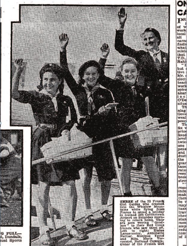
Regions: MOUNTAIN COMMENTS | TRIP REPORTS | TRACKS | SUMMARIES

tracks
TRACKS
                                                      NORTH:
                                                      Buttery Muck
                                                      Quite a creative way
                                                      of visiting some oft-
                                                      climbed summits
                                                      in the Mournes has
                                                      been uploaded by
                                                      ceadeile. The route
                                                      starts by eking a way
                                                      up to the Wall just
                                                      north of Slieve Muck
                                                      then following it anti-
                                                      clockwise down the
                                                      rough descent to the                                                           NORTHWEST:
                                                      Banns Road and on                                                              Brownstacks
                                                      up Slievenaglogh,                                                              Out in the wilds
                                                      picking up a good                                                              of the relatively
                                                                                                                                     unfrequented
path before tougher      The waterfall on the Shannagh, Doan in the background                                                       Bluestacks of
terrain and a fine       b ceadeile
                                                                                                                                     Donegal, your
waterfall on the                                                                                                                     track reviewer
way up Doan,                                                                                                                         climbed a relatively
taking in Slieve                                                                                                                     unfashionable
                                                                                   Brown’s Hill - the view to the north-east
Loughshannagh                                                                      b Peter Walker
                                                                                                                                     hill on an utterly
and Ott Mountain                                                                                                                     horrible day…
on the return. Carn                                                              yet still saw somebody else up there and interacted with someone
Mountain could                                                                   else about it online later that day…strange. Said summit was Brown’s
easily be included at                                                            Hill, and the route taken used a excellent forestry path until a direct
either end of the day.                                                           flog up an uneven mountainside led fairly quickly to the top...this
Link: https://                                                                   could be used as the start of a longer day’s summiteering in these
mountainviews.ie/                                                                Badlands, an area where you won’t see many paths.
track/report/4299                                                                Link: https://mountainviews.ie/track/report/4292/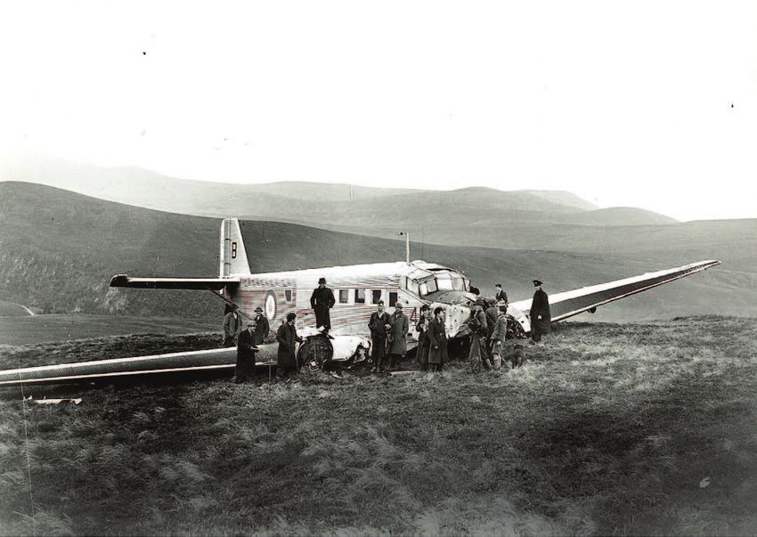
summiteering

BAN THOSE BINNIONS!
David Murphy recounts a heated
conversation with an acquaintance
THE CURRENT HIATUS ON THE HILLS PRESENTS MOUNTAINVIEWS
WITH AN IDEAL OPPORTUNITY TO DELETE MANY, IF NOT
ALL, BINNIONS FROM THE SITE – THIS SHOULD BE DONE
IMMEDIATELY!
– so begins an email from Pepé, scourge of the Irish peaks.

Pepé is serious. I know because one of the misfortunes of Covid-19
restrictions is that I live within two kilometres of him – which means
our paths often cross these days when out for daily exercise. He has
the nasty habit of ghosting alongside you when you least expect                                                         A small hill   b   Kenneth Allen
it, though he does observe the new distancing etiquette. Social
distancing should always be practised with Pepé – Covid or no Covid      Not like wasting your breath – not that you’ll need much breath –
– because of his severe lack of personal hygiene. He knows I’m into      conquering a mediocre pimple. Patrick’s Hill down in the real capital
hillwalking so regards me as a captive audience and off he goes like     is more of a challenge than those bloody binnions” – Pepé’s Cork
water gushing down a mountainside:                                       origins never take long to emerge.
                                                                             “How long did it take you to climb this binnion?” I asked.
PEPĒ’S COMPLAINT                                                             “Aaragh, about a half an ho-“
“I’m going to complain to Mountainviews,” he said. In response to my         “Well there you are!” I interrupted again. “The binnions are handy
puzzled look he went on, “The last hill I climbed, before they banned    for those who are a bit time-poor.”
the hills, is one of those blasted binnions listed on MV – and that          “What? Don’t start me off, boy!”
listing led to me wasting my time. You’ll barely break sweat on that         I shifted from one foot to another. Pepé is so easy to wind up. An
hill – a broad pathway leads all the way up – and ‘up’ is a misnomer.    avalanche this time, rather than a waterfall:
Those binnions are only blisters on the ground. You can shove ’em            “What’s the point climbing such small hills? Just to tick ’em off a
up-”                                                                     list? Proper hills – I mean mountains – that’s what should be on the
     “And your point is?” I interrupted him mid-flow.                    website. Most of those binnion things are too easy – little effort and
     “My point is you can spend three hours going up Carrauntoohill      no pain: Knockmore down near Tallow, Dunmurry Hill in Kildare,
and three hours coming down. Now that’s a mountain. That’s a climb!      Loughcrew in Meath or Carronadavderg in Waterford. If you ask
summiteering
                                                                                           If you’re climbing up Binnions,
me, little blisters like those, and Corrin and Ballydorgan hills near                          don’t forget your oxygen
Fermoy in my own neck of the woods, are examples of easy rises.
They should only be kept on MV for people who are in their dotage
or suffering from arthritis or otherwise unable to climb proper
mountains.”
   I marvelled at the man’s brass neck. Pepé claims to be in his sixties
– he looks about 103 – yet here he was foaming at the mouth about
some hillwalks being suitable only for the elderly and the infirm. He
saw my look of disapproval and started to backtrack (unusual for
him, I can tell you).

PEPĒ’S GREAT COMPROMISE
“Ok, ok. Easy little hillwalks should still be available for those not able
for real challenges.”
    “Oh, so now we should NOT ban all binnions?”
    “Well, I would be prepared to compromise.”
    How considerate of him. “What might the compromise be?” I
enquired.
    “We should all agree to park easy climbs, the Knockroes, Corrins
and Dunmurrys of this world, until we’re all getting long in the tooth.
The easy-peasy binnions – the Taras, Tullyhappys, Carronadavdergs,
Braniels, Carrickgollogans, Slanes, Lackens, Cupidstowns –
Stupidstowns,” he sniggered, “we ought to save them for tackling
when we’re old and feeble-limbed, unable for anything higher than
the merest of mounds. God knows there’s enough of them in every
county in Ireland to last us all into our zimmerframes.                           Like a lead balloon, I thought. “Brilliant idea, Pepé. You should be
    “I’m going to put up a post on the Mountainviews general                  on the Mountainviews committee. Do you think they’ll act on your
forum demanding that all binnions be age-restricted – only those              proposal?”
of 75 years or over should be allowed tick them off. In other words,              “Aaargh of course they will, boy – isn’t it only commonsensical?”
binnions should be re-classified: for the ancient and decrepit only.               “But what if they won’t get rid of the binnions, or refuse to
Can’t you see? Now’s the ideal time to re-draw the lists when there’s         introduce your minimum age restrictions as a compromise?”
this hiatus on hillwalking. My proposal is that we reduce and restrict            “Well then I’ll ... I’ll ...I’ll contact the ombudsman.”
these simple little inclines – that’s it!” I could see the cogs turning in        “What ombudsman?”
his head. “I’ll also recommend that ‘binnions’ be renamed ‘inclines’!             “The ombudsman, or maybe ombudswoman – you never can tell
What do you think? How do you think such a proposal will go down?”            these days – for ... for mountains, of course!”
adventure
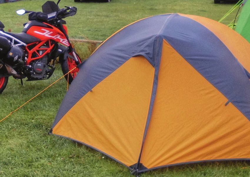
“YOU CAN TAKE YOUR
MOTORBIKE AND YOUR
HILLWALKING GEAR AND
YOU CAN CLEAR OFF!”
Bleck Cra (Douglas Reid) That’s what the pre-ex-wife said to me 25 years ago. So I
tries touring by bike where thought I would just do it again.
the hordes are not. Ageing Obsessions are a pain in the butt ... like long distance on a
small motorcycle. A pain in the butt ... and when laden down
disgracefully. Something with hillwalking gear (the other obsession), a pain pretty well
we should all try at some everywhere else.
point in our lives. But pain and gain? In spades!adventure
On the cusp of a very annoying and spied 6 below at the Cross Loweswater - Mellbreak
behind Kirkdale Inn
birthday - the one you look at and Keys. All day. 7.5 hours. May Bank
guess there must be some mistake Holiday Weekend. Visions of
- I came up with a plan "Off Off the Scafell Pike Hell entertained me.
Broad Way" - that is to say, off the
beaten track.
A plan to go 2 wheels and 2
feet to some of the top British and
Irish walking zones, keeping well The next adventure was to
away from the big tourist tops and catch the most Westerly top in the
devising some fairly tortuous routes Lake District, Blake Fell and this
A few bits of luggage off piste. kicked off from the Kirkdale Inn in
for the Bike So in May it started. The Lake Loweswater, out of an exceptional
District but "Off Off the Broad B&B in sadly diminished
Way". Whitehaven.
The Howgills to be accurate. Howgills - Contour return A merciless vertical shale ascent
The base was originally Brough before I found that walking by Adamthwaite on to Mellbreak revealed the route
anywhere near Brough could get you blown up by the MOD. So to Scaleforce Waterfall, a deluded
it moved to Kirkby Stephen, a dark stone town peeled from a detour though bracken in blazing
postcard. heat and on to Red Pike (complete with green slate), returning via a
The route out of the Black vast loop out to the Dodds, Great Borne and eventually Blake Fell
Swan in Ravenstonedale bisected and a horlicks of getting off back to the Kirkdale. Mid July - 2 at the
a herd of wild mountain horses, waterfall, 6 on Red Pike. From there you could just about hear the din
caught the windy open summits from Ben Nevis or Carrauntoohil or Slieve Donard - but Off Off the
of Green Bell, Randygill, Yarlside Broad Way, 8 souls all day.
with a grassy descent so steep Conclusions. Dodging the
it should have been crags; and hordes - good plan. Going
up into the black and stunning by motorbike - good plan.
Cautley Spout waterfall, the Howgills - local Together - a bit of an ask but
highest in England. Descending Wild Horse if you can get it right, a very,
and avoiding the Cross Keys very good plan.
Temperance (no alcohol) Inn and a wending (Thanks to Peter Walker
contour return through shadowy farmsteads ending in -thwaite and for his knowledge of all hills
clinging to craggy knolls. Loweswater - To Mell- in these islands, equalled
It was May Bank Holiday Weekend. I met 4 people on the hill break from Red Pike
only by his passion for them)Lough Adanacleveen from Slieve Carr summit area b Ilenia Venditti
b a c k pa c k i n g
Wild Nephin
2 days in Mayo’s
most remote
mountain range
Ilenia Venditti ventures into the wilds of the nephin begs
Wild Nephin is a wilderness area of 4,600 hectares of blan-
ket bog owned by Coillte. While its future is uncertain after it
was incorporated into Ballycroy National Park, back in 2013
Coillte management decided to phase out any commercial
use of the land and to rewild it.
It’s also home to some of the mountains of the Nephin
Beg range and to Ireland’s most remote mountain, Slieve
Carr.b a c k pa c k i n g
Day 1: Mount Eagle, Birreencorragh West Top, Birreencorragh
South Top, Birreencorragh, Knockaffertagh. Glennamong E Top,
Glennamong
I decided to use Letterkeen trailhead (F 96897 05564) as a base
for my two days in Wild Nephin. It is 18km north of Newport and has
a car park and a bothy, Brogan Carroll Bothy. I pulled into the car
park at 5am on July 12, 2019 and set off for Mount Eagle.
Mount Eagle is usually tackled from the south but it can be easily
reached from Letterkeen. I walked out of the car park in an easterly
direction, went up a forest track and followed an old, boggy trail that
seems to have fallen into disuse. I soon reached open hillside and
from there getting to Mount Eagle was easy enough and overall it
only took 1h40m from Letterkeen.
From this first summit it’s a short walk to Birreencorragh West Top
and across the ridge to Birreencorragh South Top and Birreencor- Letterkeen.
ragh and the views on a clear day are stunning. The last summit of
Lough Avoher Hut Stats for this
b Ilenia Venditti
the walk was Knockaffertagh, which is farther out and adds about first walk:
1h15m in each direction, and then I retraced my steps all the way to 31k, 1450m
of ascent,
8h50m.
Since I
still had a
few hours
of daylight
left, I went
up Glenna-
mong and its
satellite top.
The walk was
more difficult
than anticipated since I was tired from the first hike. The heathery
ground didn’t help but when I reached the summit of Glennamong I
was rewarded with clear views of the whole range. Stats for the sec-
ond walk: 16k, 760m of ascent, 5 hours. I was wrecked so I camped
not far from the car park.b a c k pa c k i n g
Day 2: Nephin Beg S Top, Nephin Beg, Slieve Carr, Tawnyanruddia
Slieve Carr was the main objective of day 2 but I wanted to reach
a few other peaks first. From the trailhead I followed the waymarkers
for the Bangor trail and Letterkeen Loop and once I got to the next
bothy, Lough Avoher hut, I left the main trail to start the ascent to
Nephin Beg South Top. The forested area at the base of the moun-
tain is easily avoided and the summit can be gained quickly. I was up
Nephin Beg South Top after 2.5 hours.
The pull up Nephin Beg was more difficult since you have to drop
to the col between the two mountains and then climb almost 300m.
This took approximately 1h15mins.
Next came the steep descent to the col between Nephin Beg and
Slieve Carr which affords nice views of the twin Scardaun Loughs.
Slieve Carr is quite far from Nephin Beg so if you’re running out of
time this is a good spot to turn back or wildcamp. To put this into
perspective, it took me 3h20mins and 520m of ascent to get from
Nephin Beg to Slieve Carr.
The Bangor Trail b Ilenia Vendittib a c k pa c k i n g
Wild camping near Lough Feeagh b Ilenia Venditti Some notes for walkers venturing into Wild Nephin
There is good phone coverage in the area once you’re up high
enough. Signal is spotty in the car park and can be poor while you’re
on the main Letterkeen trail since the mountains and trees might
block it.
Midges in Mayo can be ferocious. Your trusty midge repellent
might not stop them and antihistamines only go so far so bring a
good cream for bites.
The area might not be so desolate as you’d expect. The trail is
used by locals for short walks but most people wouldn’t go as far as
Slieve Carr.
Plan ahead carefully. There are no B&Bs or shops in the area so
make sure you have enough time to complete your walk, unless you
intend to wildcamp, and bring enough food with you.
The Altaconey River b Ilenia Venditti
When I reached the top of Slieve Carr I was 6.5 hours into my
walk. The summit area is quite rocky, marked by a large cairn and
trig pillar. From Slieve Carr I got to Tawnyanruddia in 1.5 hours and
carefully descended south to get back on the Bangor trail. There is a
derelict tin bothy at the base of Tawnyanruddia which still has an old
map of the Bangor trail on one of the walls.
The Bangor trail is not maintained anymore so it can be slow go-
ing when you’re crossing really wet and overgrown sections. This is
actually the part of the walk that feels the most remote. Navigation
can be difficult at times and there are no bridges or stepping stones
to cross River Tarsaghaun and its tributaries.
The walk back to the trailhead from Tawnyanruddia took 5 hours.
Back at the car, I drove off and found a nice camping spot near
Lough Feeagh. Final tally for the day: 31k, 1700m of ascent, 13hours.h i l lw a l k i n g r e a d i n g
The Angry
Corrie
An inspiration for MountainViews’s
newsletter and our members.
In our quest to come up with top
notch reading material during our
enforced downtime, forgive us for
pointing you at something non-Irish
(but at least it’s thoroughly Hibernian).
If you’ve never come across it before,
my, you’re in for a treat.
Styled as ‘Scotland’s First and
Finest Hillwalking Fanzine’ and shot
through with a level of irreverent
humour that matched its considerable journalistic
standards, for the best part of twenty years The Angry Corrie (or
TAC if you’re into that whole brevity thing) cut an uproarious swathe
through the outdoor world. Available by subscription or from
outdoor stores (but always published online soon afterwards), editor
Dave Hewitt and trusty lieutenant Perkin Warbeck’s legacy of content
in TAC itself is matchless, be it excellent cartoons, fiendishly hard
quizzes, taking on sacred cows and untouchable public figures (say
hello, Cameron McNeish!), or mercilessly mocking summit bagging
while simultaneously revelling in it. And that’s before you get to
the little cottage industry of books they spawned, a lot of it list-
related but also including Hewitt’s lovely account of a marathon walk
through the Highlands, ‘Walking The Watershed’.
So, from the wonder of the WayBack Machine, here are most of the level to which I’ve aspired. And aspiring’s almost as good as
the issues archived: achieving, isn’t it? [ED: Hopefully others will think kindly of what we
http://web.archive.org/web/20120908215543/http://bubl.ac.uk/ have done, but, no, aspiring was never as good as achieving].
org/tacit/tac/
In all the time I’ve spent writing about the mountains, theirs is Peter Walkerchallenge
reports and upcoming events in the challenge walks calendar
the toughest.
EXTENSIVE, EXTENSIVE... SURVEY??
Do you know the age old expression
“Judge’s decision final”...? Good!
Then we can continue. If not - go
back to Start! Do not pass GO, do not
collect £200!
Whilst the Challenge Walks
Calendar is a tad quiet this weather
what better opportunity to reflect on
what Walks were voted the toughest
Challenge Walks in Ireland!
The extensive survey, that was
collated over an extensive period of
well over ten (very, very extensive)
years, enjoys an incredible algorithm
that means any of the Walks can
jump (or fall) at least three places
“in the charts” depending on the
conditions that the day throws at the
would be walker on the morning of
each great event!
Now to give you the full top ten
would take a little too much time
Checkpoint on the Glover Highlander
- and heaven knows just how busy
we all are at the moment, what with
Editor’s note: Our ever-enthusiastic Challenge correspondent, Jim,
online shopping for hair-clippers and Zoom meet-ups with the aunts
has produced the results of his survey into what is the toughest
and uncles who we were previously happy to only have to talk with in
Challenge Walk in Ireland. There are of course some unique features
short doses at long drawn out weddings!
of the methodology of this survey. While the criteria for “toughest”
So the full chart listings can be found at...
would need to take into account the physical difficulty some would
https://mountainviews.ie/FAQ/challenge/
say navigational and practical difficulty would need to feature. And
then there is the number of respondents to the survey: currently this is
RE-ENTRIES AND NON-MOVERS!!
exactly one, the author.
At the end are some comments from Gerard Sheehy, well known But without any further ado, a re-entry at number 5 is the mighty
challenge walk organiser and participant. Mourne Seven Sevens! There is a lot of honest graft packed into thischallenge
reports and upcoming events in the challenge walks calendar
walk, not least the highest peak in Ulster. But for the most part there Altan Castle, Glover Highlander
is always a well-defined track; a nice big high wall for shelter and
tricky navigation is kept to a minimum! The incredible Mourne Wall is
a feature to behold and what’s more - if it’s windy on one side, then
walk on the other... and if it’s windy on the other side?? Yup, you’ve
guessed it!
Anchored at number 4 is the historic Glover Highlander!
Two of Ireland’s most beautiful mountains - Muckish and Errigal . . .
and everything in between, what can go wrong! Whilst there is many
a shortcut that can be taken - this is not the style of the relentless
Challenge Walker. The full walk in all its glory can all too easily be
dependent on the mercy of competent navigational skills and the
wild Donegal weather!
A non-mover on the Charts at number 3 is the Twelve Bens.
From the Inagh Valley all the way home to Letterfrack... and all of
the Twelve Pins that peer down in all of their majesty. This has the
better tracks of the West of Ireland Hillwalking fraternity... but there
is a serious amount of climb to be bested! As it always seems that Whilst this walk has better supporting checkpoints than many - there
the walker is having to constantly ascend... there isn’t the intense will always be the mileage to contend with. If the day is fine, then
navigation of some walks. Should this walk even be in the list...? there’ll be a free bounce throughout the day, but if the weather
Absolutely - as we all eagerly await its return! turns... there is no escape. On occasion this walk has even tested the
resolve of the stewards manning the Checkpoints! Near on all of the
DISGRUNTLED RUMBLINGS!! Wicklow Way has to be ventured too - not least the highest peak in
At number 2 we have... The Maumturks Challenge! Leinster! From Stone Cross to the Glen of Imaal, with all its navigation
Less of the disgruntled rumblings from the back there please... in between - this will always be a full day - whatever the weather!
What did we say about “Judge’s decision final”!!
A classic Ridge Walk - the Maumturks are etched in the mind-set of A GEANSAÍ LOAD OF FREE STUFF!!
every Challenge Walker. A localised and not always friendly weather I’ve purposely left out the numerical nitty-gritty from these great
system dictates everything pertaining to the day’s walk! On a clear Challenges . . . very important to tease you to the full article as
day, many have asked “what’s all the fuss” . . . but there have been embedded on the MountainViews website.
days in snow, days in unrelenting wind that would spilt a flea . . . and https://mountainviews.ie/FAQ/challenge/
days when the mist descended and there is nothing but whiteout and Here you can find all manner of valuable information from the
serious navigation for a solid twelve hours! Oh and it’s also totally total ascent of the Walks to the total length of underfoot graft. There
unsupported... everything you may require - you may carry! are reports and photos from the events, and many even have their
And at number 1, Judge’s decision, Judge’s decision... is the Lug Walk! relevant GPX track available for download.challenge
reports and upcoming events in the challenge walks calendar
And as all of this is totally free - you’d have to admit - it’s pretty good excuse not to plan your next picnic (in a sun-drenched dunes), when
value for money!! some sense of normality does return...
Yeah, the old jokes are the best... but in these strange times, I have Onwards and upwards boys and girls, big hug (from a social
to always hope that I’m still attracting a new audience to my rants and distance), keep safe and enjoy your day,
raves! Jim Holmes.
TAKING A CONTOURING ROUTE!! Comment from Gerard Sheehy
Taking a slightly different route now (something that we’re well I’m not qualified to say whether Jim’s rankings are in the right order
renowned for in the world of Challenge Hillwalking)... a close friend for single day challenges. I’ve never done the 7 7s (I’ve done the
of mine has a simple photograph on his mantelpiece... it took years of Mourne Wall Walk) and I’ve never done The Lug (nor is the desire
friendship before I asked him about it... there).
It is a photograph that no doubt we all can picture... My only comment would be that, back in the day (circa 2002),
It is in black and white - and of what can easily be conceived as a The 12 Bens Challenge consisted of taking in the 12 listed Bens
bunch of people having (for want of better and more justifying words) of Derryclare, Bencorr, Bencollaghduff, Benbrack, Bencullagh,
a picnic together outside on sun-drenched dunes... Muckanaght, Benfree, Benbaun, Benbreen, Bengower, Benlettery
The significance of this photograph is that this would be the last and Benglenisky. There are a few ways to take all these in in the one
time that these people, in reality the nine of my friend’s father’s family linear walk and no matter what way you go about it it’s a 30km walk
would ever be together. The following week saw the outbreak of the with circa 3,000m ascent/descent. Of the single day challenges, that
Second World War. Two of the brothers were killed and another spent are/were hosted by clubs, and that I’ve done, that’s the one definitely
over 3 years in a Japanese labour camp. ranked at Number 1, for me.
Born in a time of good music and no war... my generation was I think the continual gradient of the climbing, on difficult terrain,
always reminded just how privileged we are - and in all fairness I can’t is like no other. And, depending on what way you do it, there are
argue with this. three descents that are painstakingly slow due to their difficult nature.
But for all I know, at this given point in time - we are in a kind Getting from Benbrack to Bencullagh (or vice-versa) isn’t for the faint
of war of sorts that hopefully will be totally unique to our own hearted. I’ve done the routes on good days and I’m not too sure I’d
generation... fancy having a go at the Listed 12 on a wet and windy day. There
[ED: Sadly, I think the peace has crumbled and Covid-19 is a are good exits on the Lug and Turks but you’d want to be pretty
harbinger of far worse we’ll need to fight, though we’ll win the war committed to finishing the full walk on the Bens. ‘Escape’ is difficult.
against Covid eventually] You’d need a very resourceful and strong club to put this
Now more than ever staying positive is very, very important. magnificent challenge back on the calendar. That said, it would be an
The incredible resource that is MountainViews, continually strives to ideal challenge for the representative body for challenge hillwalkers,
build on community - so dig a little deeper into the website and make Mountaineering Ireland, to host for their members. Costs would
plans for your next Walker Day Out! With the website showing us over be minimal, they’d have no problem rounding up volunteers and it
400 mountains over 500 metres, with Coastal Routes and Vandeleur- would be the mother and father of all commitments to their loyal, self-
Lynams, with The Arderin List and countless GPX tracks . . . there is no sufficient members who take full responsibility for what they do.lockdown fun
emoji quiz part 2 of 2
Member Tom Barragry invites you to try to
figure out what each place is usually called.
Licensed for reuse CC BY-NC-SA 4.0
Answers will be linked from here in a few days.h i s t o r ic a l
The crashed Junkers -52 on the mountain side of White hill
Wicklow, with Luggala and Lough Tay in the background.
(Irish Independent Aug 15th 1946)
The Djouce/White Hill
Air Crash of August 1946
Tom Barragry
Introduction as their military plane crashed into the side of Djouce mountain
On August 12th 1946 a plane carrying Girl Guides to an international at White Hill. The young French girls were greatly looking forward
Guide camp in Dublin crashed in bad weather on Djouce mountain to their Irish holiday, where they would not only meet the Irish Girl
in Co Wicklow at around 12.30 pm. The French teenagers were be- Guides but also Guides from Holland who were arriving in Ireland
ing flown to Dublin for a much-anticipated holiday with their Irish by boat. Miraculously no one was killed in the crash and many of the
counterparts in the aftermath of the devastation and destruction of French Girl Guide survivors returned to Ireland over fifty years later
WW2. Most, if not all of them, had never flown before and little could to visit the site of the crash and to renew acquaintance with their Irish
have prepared them for the disastrous journey that awaited them, friends and rescuers.h i s t o r ic a l
The Story feet high…in-
On board were 21 young French Girl Guides, aged 13-17, who were cluding Djouce
due to spend a short holiday in Rathfarnham in Dublin courtesy of which is 2400
the Irish Girl Guides Association. Seating inside the aircraft, similar to feet high. [Ed.
most military aircraft, was on coarse bench seats running the length Ahem, the
of the cabin, along the unpadded interior aluminium walls of the air- pilot probably
craft, with the two rows of passengers facing each other. The Junkers used metres
52 plane was silver coloured from the corrugated metal alloy skin and Djouce
enveloping it, with the French tricolour painted on the rudder. There we have now
was no sound proofing, nor insulation, and once airborne, the noise established is
echoing inside the bare metal plane was truly deafening. 725.5m]
The plane was fitted with only sixteen seating places, so five of the The Junkers
girls had to sit on the floor. In addition to the twenty-one French girls, 52 aircraft had
there was also a crew of five the flight would be over four hours long, in fact veered
and the conditions inside the uninsulated cabin made for a cold, seriously off
noisy and somewhat uncomfortable flight. course be-
cause of major
The Journey problems with
At the outset of the journey, the weather over France was good and visibility and
relatively clear and gave no hint of the bad weather of rain and winds
that was to await them as they approached the Irish coast. The cloud
cover built up over England and Wales, and so the plane kept a
relatively low flight level there, rarely flying higher than an altitude of
7000 feet. Passing over Wales, the plane had to descend from thick
dense cloud cover in order to maintain a clearer visual heading.
Over the Irish sea however, the plane hit more stormy weather,
very low cloud cover, and visibility was reduced to almost nothing.
At 11.35 a.m. as the plane initiated its descent towards Dublin, it ran
into very turbulent weather conditions with torrential rain and gale
force winds and the pilot was no longer sure of his exact position.
Radio contact with the airport at Collinstown was lost because of the
low altitude and mountainous terrain.
The plane appears to have crossed the Wicklow coast in almost
nil visibility flying in a north westerly direction at an altitude of 1400
feet in a mountainous area where several peaks are in excess of 2000 The Wicklow crash as depicted in the Irish newspapers on August 14th 1946h i s t o r ic a l
navigation. The pilot was well south of his correct heading, flying low eventually made their way through Glensoulan valley in the direc-
into the Wicklow mountains, instead of being, as he thought, well tion of Powerscourt waterfall, where they saw smoke from a distant
north of them. Local inhabitants remarked upon seeing a very low cottage in the valley below them. They somehow managed to scale
flying noisy plane suddenly tilt and change direction towards Lough and scramble down the sheer cliffs at the side of the waterfall. They
Dan, and they assumed that the aircraft above them was lost. made their way to the cottage, and having explained their story to
the astonished owners they then learned that the nearest phone
Djouce was over a mile away. Chantal, the Guide leader, went onwards and
While attempting to drop the plane to an even lower altitude, be- made it eventually to the Mount Maulin Hotel 5 miles from Ennisker-
low the dense clouds in order to get a better forward view from his ry. Some two hours later, the navigator, Michel Tourret and the wire-
cockpit window, what Captain Habez actually saw to his sudden less operator Daniel Duran, staggered into the front hall of Luggala
horror was that he was on a direct collision course for a mountain. In House on Lough Tay and raised the alarm.
panic, he pulled back suddenly on the control column joystick to lift
the nose up, but it was too late, and the boxy Junker 52 shuddered, The Rescue
slid and thumped into the mountain side, coming to rest in the soft, The garda station in Enniskerry was notified and a call was put
heather covered muddy bog land at White Hill, on the south west through to Bray garda station at around 7pm. A rescue operation was
shoulder of Djouce. Luckily enough, by pulling the nose up, and by then put into effect and local and emergency services combined to
being at the lower slopes of the Djouce mountain the plane tended locate the missing aircraft.
to pancake or belly flop at an upwards angle into the soft terrain, Initially the search swept over the wet misty landscapes along
thus minimizing extensive damage to the aircraft. The fuselage re- the mountains from the Sally Gap to the Tonduffs and onto Maulin.
mained more or less virtually intact there was no fire but much petrol Streams, rivers, rocks, muddy tracks, boulders, sharp ascents and
and oil spilled around the crash site. descents, all had to be encountered and carefully navigated by the
rescue parties in poor weather conditions. Armed with torches, the
Searching for Help search continued into the misty darkness as more heavy rain and fog
No one was killed inside the plane although seven or eight of the came down at 10.30 pm. As news gradually spread around the local
Girl Guides were seriously injured suffering from shock and many country side that the missing plane had been located on White Hill,
with broken bones. When the leader of the French Guides, Chantal at the south west side of Djouce, a full-scale rescue operation swung
de Vitry, (aged 21) clambered out from the wrecked aircraft in search into action. As the fog suddenly lifted two Enniskerry men who had
of help, she had absolutely no idea of where she was. All she could been searching for hours but to no avail, were amazed to suddenly
see was a desolate, grey lonely mountainous landscape all around see the outline of the crashed plane materialize out of the fog in
her, shrouded in lashing rain and thick fog and mist. Captain Habez, front of them. There, resting on the dark mountain side, surrounded
and another Guide, Andree Bonnet joined her. It was miserable wet by debris, oil and petrol pools, was the crashed aircraft with the fro-
weather as they set off in search of help. It was now around 12.30pm zen and frightened girls inside. It was almost midnight, 12 hours after
and Chantal would be searching for help for another seven hours the crash before the wrecked aeroplane was fully discovered by the
After wandering for hours in atrocious wet misty conditions, other rescue parties on the gale swept ridge at an altitude of 1800
through bog land, streams and rivers, Chantal and her companions feet. [Ed, well it’s at about 620m]h i s t o r ic a l
Down from the Mountain In Hospital
Sheepbank House, on the edge of Luggala estate on the Sally Gap During their stay in the two hospitals, the girls and crew were visited
roadside below Djouce, was the first holding point down to which regularly by various dignitaries, delegates from the French legation
the survivors were brought, and where they sat by a warm fire and politicians, pressmen and also their colleagues from the Irish Girl
received hot tea, and some received hot whiskey and brandy. The Guides. The air crash was front page news for days in the “Irish Press”,
ambulances and medical aid assembled there, and after giving “Irish Independent” and the “Irish Times” and also in some French
the initial medical attention to the survivors there, the injured were newspapers, with extensive reports, interviews with the pilots, photo-
brought by a fleet of ambulances to St Michael’s hospital in Dun graphs and maps of the crash site .
Laoghaire and also to St Bricins hospital on Dublin’s northside.
Going Home
On August 16th 1946, four days after the crash, three of the hospi-
talized girls were discharged and allowed to go to the summer girl
guides camp in Rathfarnham where they would meet the other Irish
and Dutch guides for a short period. After that they would be going
home to their parents in France, by plane. The first Girl Guides to be
discharged from hospital flew home on August 17th together with
Daniel Duran the wireless operator. Four days later Michel Tourret,
the co-pilot, Georges Biagioni, the navigator and the pilot, captain
Christian Habez returned home.
On October 21 the last four girl guides were airlifted back to
France on stretchers. The kindness shown to them everywhere dur-
ing their stay in Dublin made a huge impression on the girls and
indeed particularly also on the pilots and crew, who specifically re-
marked on their return to France that they were quite overcome with
the warmth and assistance shown to them in Ireland.
Sequel
Following a joint French -Irish enquiry as to the cause of the crash, an
official statement was issued shortly after the event, to the effect that
the Junkers accident was due to navigational errors, exacerbated by
the very poor weather conditions prevailing at the time and that the
pilot had been flying well south of his track and was not flying high
enough to avoid the Wicklow mountains.
In 1996, there were twenty of the original guides still alive. A
August 15th 1946 reunion of the survivors from the Djouce crash took place in Franceh i s t o r ic a l
that year and they decided to plan for a subsequent nostalgic return
trip to Ireland, to mark the 50th anniversary of the crash. This return
visit took place two years later in 1998, some fifty-two years after the
crash.
Fourteen of the Guides returned to Dublin in 1998 and visited
St Michaels and St Bricins hospitals, where they once were patients.
They reunited again with some of the Irish Girl Guides from fifty
years ago, and also renewed acquaintance once more with some of
those people who had been involved in their rescue and subsequent
recovery in 1946. During their nostalgic visit to Dublin in 1998 the la-
dies travelled by coach by along the Sally Gap road and parked just
under Djouce, overlooking Lough Tay and Lord Oranmore & Brown’s
house. They visited the nearby ruins of Sheepbank House on the
road, and then they proceeded along the board walk ascent, up past
the JB Malone memorial, looking down on Lough Tay, Knocknaclog-
hogue valley, with Lough Dan in the far distance.
They could see White Hill, and the shoulder of Djouce for the
first time again in 52 years . As they gazed at that spot what their
thoughts were, what their memories were, and what their emotions
were one can only guess.
Today no plaque marks the spot of the crash, despite many petitions
over the years to do so. In the lead up to the 60th anniversary of the
crash the idea of a commemorative plaque was suggested to the
NPWS but it was flatly rejected as were subsequent overtures.)
For an excellent overview and more detailed account of this story
read “When Our Plane Hit the Mountain” by Suzanne Barnes. It is a
well-researched, comprehensive and highly detailed account of the
entire event and is a most gripping and interesting read. The book
was used as a source for some of the material in this article and very
extensive use was also made of the national newspaper archives and
some other library sources.
The first of the Guides return home August 17th 1946Photo OF THE MONTH Annacoona and Benwiskin b ochils_trekker Original summit comment: https://mountainviews.ie/summit/282/comment/20777/
Editor’s Additional Picks
                                       More examples of outdoor photography from our members

                                                                        Bluebells, Capard Wood b melohara
                                                                        Original comment: https://mountainviews.ie/summit/505/comment/20776/

Doonvinalla E Top b magnumpig                                           Coire na nGarru b markwallace
Original comment: https://mountainviews.ie/summit/5064/comment/20778/   Original comment: https://mountainviews.ie/track/4296/
Editor’s Additional Picks
More examples of outdoor photography from our members
North-east from Slieve Carr b markwallace
Original comment: https://mountainviews.ie/track/4296/
Ess-na-Larach waterfall, Glenariff b Peter Walker South from Tawnyanruddia b markwallace
Original comment: https://mountainviews.ie/track/4293/ Original comment: https://mountainviews.ie/track/4296/EMVEE-TUBE
the best video picks for may
A Swiss artist uses the world’s most singular mountain as a canvas Exploring the boundaries of human patience…oops, I mean endurance
https://www.youtube.com/watch?v=imMHID9d41E at home
https://www.youtube.com/watch?v=5nU2ZEjgRF4
World-renowned mountain photographer and guidebook author Walter MV user gerrym has a mooch around Murlough Bay in County Antrim.
Poucher is an unwitting onlooker to a classic chat-show moment [ ED: https://www.youtube.com/watch?v=yCnjiS9hxGw
distinctly limited relevance to hillwalking, but hey it’s all good distraction]
https://youtu.be/iz_UHLfZKAAnotices
• If you are contributing, please be careful to respect the interests tipping in the Republic - ring EPA hotline 1850 365 121
of landowners. Suggest access routes well away from houses, • Report quads in national park area (in which they are banned).
gardens or that could conceivably impact farming activities. For Wicklow please phone the Duty Ranger: 087-9803899 or the
When walking, keep away from gardens or farm buildings. Use office during office hours Telephone: +353-404-45800. Put these
stiles or gates wherever possible. Never do anything that could numbers in your phone, take regs etc. Let MV know of contact
allow animals to roam where the farmer did not intend. Ask numbers for other areas.
permission where appropriate.
• If you see a fire or someone doing something that could start
• Report suspicious activity to the police forces, as below. a fire, report it. In NI phone 999, in the Republic 112 or Coillte:
• If your car is broken into in an upland area report it to the PSNI 1890 800 455.
or Gardai as this will help them be aware of the issue and tackle • If you have climbed some of the less well known places, we
it in future. Store the numbers. In Northern Ireland use the PSNI would appreciate a summit rating and also GPS readings for
non-emergency number 0845 600 8000. In the Republic you can summits.
find the local Garda District HQs phone numbers at https://www.
garda.ie/en/Contact-Us/Station-Directory/. Specifically for the • If we can, let’s make MV have more than one route up a summit
hotspot of Wicklow: the Garda Divisional Headquarters in Bray is so as to reduce the tendency for paths to appear. Your grid
01 6665300. refs in place comments for different starting points show up on
MountainViews maps.
• If you hear of a problem area or route, write it up in
MountainViews which does everyone a service. Report rubbish Visit the MountainViews Facebook page:
facebook.com/mountainviewsie/
this newsletter
Editor: Simon Stewart, Homepage: www.simonstewart.ie Newsletter archive:
Assistant editors: Colin Murphy, David Murphy View previous newsletters mountainviews.ie/newsletters/
Challenge Info: Jim Holmes UNSUBSCRIBING If you don’t want to receive any further monthly
Track reviews: Peter Walker newsletters from MountainViews, look at the email we sent you that
Book reviews: Conor Murphy, Aidan Dillon, Peter Walker this PDF is linked from. At the bottom click the button “Click here to
Videography: Peter Walker unsubscribe from Monthly Newsletters”.
Graphics design: Brendan O’Reilly Alternatively let us know by email at admin@mountainviews.ie
Donating: Click on mountainviews.ie/donate/ Include the email address you got this at or your screen-name.You can also read