2022 ANNUAL HURREVAC WEBINAR SERIES - June 6-10, 2022
←
→
Page content transcription
If your browser does not render page correctly, please read the page content below

2022
ANNUAL HURREVAC WEBINAR
SERIES

June 6-10, 2022
ADMINISTRATIVE DETAILS

• Audio                                • Agenda
  − All lines muted                       − 5 consecutive days
                                          − Daily at 2pm ET
• Questions                            • Feedback
  − Submit in Question box
                                          − Daily survey mechanism
• Handouts                             • Certificate
  − Slides and Quick Reference Guide      − Sent via Go to Webinar email
    are available for download
HURREVAC WEBINAR SERIES
Day 1 – An Introduction to HURREVAC and General Overview of the
                             Program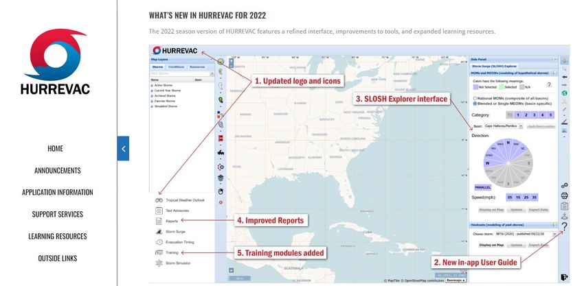
AGENDA

JUNE 6: Introduction to HURREVAC and General Overview of the Program
                     JUNE 7: Wind Forecast Features
                  JUNE 8: Evacuation Timing Features
            JUNE 9: Storm Surge and Other Water Hazards
           JUNE 10: Exercise Tools and Applying HURREVAC

                 Visit hurrevac.com/learning-resources/training-events
              to register for live webinars or watch past recorded sessions
INTRODUCTIONS

                           Marco Ciarla
MEET THE   National Hurricane Program Manager, USACE
                 Marco.N.Ciarla@usace.army.mil
TEAM
                          Thomas Laczo
           National Hurricane Program Manager, USACE
                Thomas.D.Laczo@usace.army.mil

                       Karen Townsend
                     Sea Island Software
             karentownsend@seaislandsoftware.biz

                                                       5
NATIONAL HURRICANE PROGRAM PARTNERS

                                      6
NATIONAL HURRICANE PROGRAM PARTNERS

                                      7
NATIONAL HURRICANE PROGRAM

HURREVAC (short for Hurricane Evacuation) is a storm
             tracking and decision support tool.
             The software combines:
             •    Live feeds of tropical cyclone forecast information
HURREVAC     •    Storm Surge Modeling

BACKGROUND   •    Data from various state Hurricane Evacuation Studies (HES)

             The main goal of HURREVAC is to assist the emergency
             managers in making evacuation & response decisions
             based on the timing and potential severity of storm effects
             such as wind and storm surge.
                                                                           9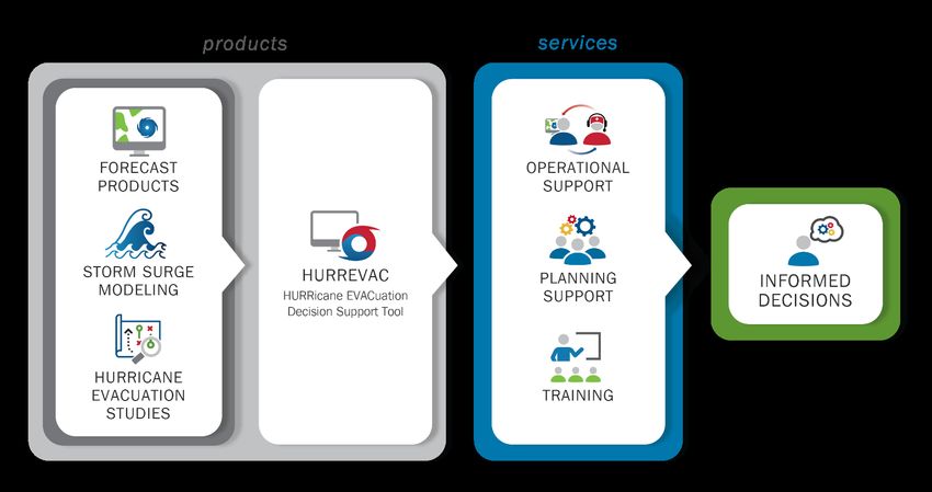
HURREVAC
USER STATISTICS
Web-based HVX platform of HURREVAC Peak concurrent usage of HURREVAC in 2021
transitioned to Sea Island Software beginning in was during Hurricane Ida ~ 1,400 users in-
2017 session
Currently supporting +21,300 registered Peak concurrent usage of HURREVAC in 2020
HURREVAC users was during Hurricane Laura ~ 2,100 users in-
session
4,300 new users added since April 2021
Plans for 2022 include greater capture of user
Application is configured to scale within AWS metrics
GovCloud, meaning that HURREVAC’s userbase
can grow to 25,000 or more.HURREVAC DEVELOPMENT
OVER RECENT YEARS
Full Transition to Web-Based Inclusion of Time of Departure Storm Simulator for creating,
HURREVAC data, and refinements to tools for editing, and sharing exercise
probabilistic timing storms
Inclusion of high-resolution storm
surge Maximum of the Maximums Redevelopment of the Clearance New export capabilities for GIS
(MOMs) and Maximum Envelopes Times Viewer, timeline actions, and Excel spreadsheet
of Water (MEOWs) and graphical timing arcs
Inclusion of SLOSH hindcasts
Inclusion of Operational Storm Revamp of the HURREVAC Support from ended storms
Surge for all storms (active and Site
archived) Initial development of new help
Establishment of the HURREVAC system within the application
Time of Arrival Graphics YouTube Channel
2019 2020 2021WHATS NEW IN HURREVAC IN 2022?
NATIONAL HURRICANE PROGRAM PARTNERS

        Screenshot from hurrevac.com   13
New User Guide
• Interactive system that allows users to learn about all
products & functionalities within HURREVAC
• Accessed in Map Tools and Utilities (bottom-right)
• Tip: Use “-Search-” in the top-right to find info on
specific topics
WHATS NEW
IN 2022
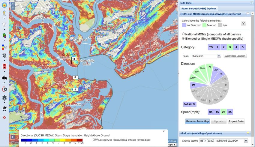
14SLOSH Explorer Upgrades
• Updated interface
• Accessed from the “Storm Surge” button in the
Toolbox (bottom-left)
• Ch3 Basin released in February
WHATS NEW
IN 2022
15Report Enhancements/ Upgrades
• Enhancements to performance and layout:
• Closest Approach Report
• Wind Probabilities Report (multiple location)
WHATS NEW
IN 2022
16Self-Guided Training Modules
• Reintroduction of self-guided training modules
• Accessed through the “Training” button in the
Toolbox (bottom-left)
• Three trainings:
• Introduction to HURREVAC; Customizing the
Workspace; and Decision-Making Worksheet
WHATS NEW
IN 2022
17OTHER CHANGES OF NOTE
Cumulative Day 1-3 Excessive Rainfall Outlook (see “Conditions” Tab) and revised
probabilities for color-coded risk categories issued by Weather Prediction Center
Renamed “Reports” (previously “Reports and Graphs”) and “Potential Storm Surge
Flooding” (previously “Operational Storm Surge Products”)
WHATS NEW Surge Flags in Potential Storm Surge Flooding are shaded pink to differentiate from other
surge-related layers
IN 2022 Storm Simulator is no longer in beta version and has context-specific help button
Geographic descriptors in the heading of each area listed in the Tropical Weather Outlook
Potential Track Area (Error Cone) slightly narrowed as a result of NHC’s improving accuracy
in forecasting storm tracks. Cone definitions for Eastern Pacific Basin and JTWC areas of
responsibility also changed slightly
See more information on hurrevac.com or
in the HURREVAC User Guide 18WHATS COMING?
What’s coming on the horizon?

               • In-app notifications/system messaging/alerts:
FUTURE               •   Keep users better informed of changes to HURREVAC
                         functionality, new forecast product availability, special advisory
DEVELOPMENTS             issuance, and more.
               • Points-of-interest:
                     •   Improve management and display capabilities for user-defined
                         locations; expand application in reports
               • Evacuation scenarios:
                     •   Make clearance times and other possible preparatory actions
                         easier to visualize in graphs that show the ranges of hours
                         needed for completion ahead of the start of hazardous conditions

                                                                                       20
HURREVAC TRAINING
HURREVAC TRAININGS

  WHO & WHERE: Government emergency managers
   •   EOCs
   •   National Conferences
   •   FEMA training courses
   •   Annual webinar series

2021 HURREVAC TRAINING HIGHLIGHTS:

  • 19 customized virtual sessions
     • 550+ participants
     • Spanish version developed for Puerto Rico

  • Annual Webinar series
     • 1,500+ participants
     • 1,400 YouTube views
Looking for more HURREVAC Training?
HURREVAC
TRAINING
CUSTOMIZED SESSIONS:
• The NHP coordinates with emergency
management agencies to customize
webinars to meet training needs.
• In-person & virtual in 2022!
5-DAY ANNUAL WEBINAR SERIES:
• Live recordings will be available on
hurrevac.com hurrevac.com and YouTube
23HURREVAC USE CASES
HURREVAC OPERATIONAL SUPPORT USE CASES
Operational Support:
View Tropical Weather Outlook
Monitor Storms & Track Forecasts
Assess Wind Speed Probabilities
Estimate Arrival and Departure of
Tropical Storm Force Winds
Understand Storm Surge Risk
Support Evacuation Decision-
Making
Develop Decision TimelinesHURREVAC PLANNING SUPPORT USE CASES
Planning Support:
Develop Simulated Storms
Understand Storm Surge Risk
Evaluate Decision Timelines
Access Hurricane Evacuation
Studies
Consider Scenarios to Support
Planning, Training, and ExercisesDEMO
REGISTER FOR HURREVAC

     Or click- Register Here
Thank You! HURREVAC Support Team support@hurrevac.com
2022 ANNUAL HURREVAC WEBINAR SERIES June 6-10, 2022
ADMINISTRATIVE DETAILS
• Audio • Agenda
− All lines muted − 5 consecutive days
− Daily at 2pm ET
• Questions • Feedback
− Submit in Question box
− Daily survey mechanism
• Handouts • Certificate
− Slides and Quick Reference Guide − Sent via Go to Webinar email
are available for downloadHURREVAC WEBINAR SERIES Day 2 – Wind Forecast Features
AGENDA
JUNE 6: Introduction to HURREVAC and General Overview of the Program
JUNE 7: Wind Forecast Features
JUNE 8: Evacuation Timing Features
JUNE 9: Storm Surge and Other Water Hazards
JUNE 10: Exercise Tools and Applying HURREVAC
Visit webinars.hurrevac.com to sign up for live webinars or watch past recorded sessionsINTRODUCTIONS
Dan Brown
MEET THE Warning Coordination Meteorologist and Senior
TEAM Hurricane Specialist, National Hurricane Center
daniel.p.brown@noaa.gov
Karen Townsend
Sea Island Software
karentownsend@seaislandsoftware.biz
5HURREVAC WEBINAR SERIES
Day 2 – Wind Products
NHC WIND PRODUCTS
Critical for preparedness and evacuation decision making
• Deterministic:
− Based on a Perfect NHC Track & Wind Radii Forecast
− No forecast uncertainty
− Only provides information out to 72 h
• Wind Speed Probabilities:
− Accounts for Track, Intensity, and Size Uncertainty
− Chance of TS, Strong TS, and Hurricane-force winds
− Time of Arrival (TOA) of TS-force windsHURREVAC WEBINAR SERIES
Day 2 – Wind Products
Tropical Storm Michael
...MICHAEL ALMOST A HURRICANE... ...HURRICANE WATCH ISSUED FOR THE FLORIDA
PANHANDLE AND FLORIDA BIG BEND...
4:00 AM CDT Mon Oct 8
Location: 20.6°N 85.5°W Public Aviso Forecast Forecast Wind Speed
Moving: N at 7 mph Advisory Publico Advisory Discussion Probabilities
Min pressure: 983 mb #7 #7 #7 #7 #7
400 AM CDT 400 AM CDT 0900 UTC 400 AM CDT 0900 UTC
Max sustained: 70 mph
NWS Local US Watch/
Products Warning
613 AM CDT 452 AM CDT
Wind Speed Arrival Time Wind Warnings/Cone Warnings/Cone Warnings and
Probabilities of Winds History Interactive Map Static Images Surface Wind
Key Storm Surge Storm Surge U.S. Rainfall Flash Flood
Messages Inundation Watch/Warning Potential PotentialFORECAST ERROR CONE
The cure for the skinny black line?
ERROR CONE
• Probable track of the center of
the tropical cyclone
• Formed by connecting circles
centered on each forecast point
• Each circle uses NHC historical
(5-year) track errors
Actual storm position will be within
the circle 67% of the timeFORECAST ERROR CONE
No worries, not in the cone?
ERROR CONE
• Only displays information
about track uncertainty
Nothing about specific impacts
• Impacts can occur well outside
the area enclosed by the cone
Center is expected to be outside the
cone about 1/3 of the timeFORECAST ADVISORY
Position. Size. Radii. Intensity.
TROPICAL STORM MICHAEL FORECAST/ADVISORY NUMBER 7
NWS NATIONAL HURRICANE CENTER MIAMI FL AL142018
0900 UTC MON OCT 08 2018
A TROPICAL STORM WATCH HAS BEEN ISSUED FROM THE SUWANEE RIVER TO
ANNA MARIA ISLAND FLORIDA...INCLUDING TAMPA BAY.
PRESENT MOVEMENT TOWARD THE NORTH OR 360 DEGREES AT 6 KT
ESTIMATED MINIMUM CENTRAL PRESSURE 983 MB
MAX SUSTAINED WINDS 60 KT WITH GUSTS TO 75 KT.
50 KT....... 80NE 80SE 0SW 0NW. Current wind radii
34 KT.......120NE 150SE 90SW 100NW.
12 FT SEAS..135NE 120SE 30SW 60NW.
WINDS AND SEAS VARY GREATLY IN EACH QUADRANT. RADII IN NAUTICAL
MILES ARE THE LARGEST RADII EXPECTED ANYWHERE IN THAT QUADRANT.
REPEAT...CENTER LOCATED NEAR 20.6N 85.5W AT 08/0900Z
AT 08/0600Z CENTER WAS LOCATED NEAR 20.2N 85.5W
FORECAST VALID 08/1800Z 21.7N 85.6W
MAX WIND 70 KT...GUSTS 85 KT.
64 KT... 30NE 30SE 0SW 0NW.
50 KT... 90NE 90SE 30SW 30NW. Forecast wind radii
34 KT...130NE 150SE 90SW 120NW.
FORECAST VALID 09/0600Z 23.5N 86.1WFORECAST ADVISORY
Position. Size. Radii. Intensity.
WIND RADII
TROPICAL STORM MICHAEL FORECAST/ADVISORY NUMBER
NWS NATIONAL HURRICANE CENTER MIAMI FL
7
AL142018
• NHC forecasts the wind radii in four quadrants
0900 UTC MON OCT 08 2018
A TROPICAL STORM WATCH HAS BEEN ISSUED FROM THE SUWANEE RIVER TO
ANNA MARIA ISLAND FLORIDA...INCLUDING TAMPA BAY.
Radii are the largest distance
PRESENT MOVEMENT TOWARD THE NORTH OR 360 DEGREES AT 6 KT
from the center in a quadrant
ESTIMATED MINIMUM CENTRAL PRESSURE 983 MB
MAX SUSTAINED WINDS 60 KT WITH GUSTS TO 75 KT.
50 KT....... 80NE 80SE 0SW 0NW.
34 KT.......120NE 150SE 90SW 100NW.
12 FT SEAS..135NE 120SE 30SW 60NW.
WINDS AND SEAS VARY GREATLY IN EACH QUADRANT. RADII IN NAUTICAL
MILES ARE THE LARGEST RADII EXPECTED ANYWHERE IN THAT QUADRANT.
NW NE
REPEAT...CENTER LOCATED NEAR 20.6N 85.5W AT 08/0900Z
AT 08/0600Z CENTER WAS LOCATED NEAR 20.2N 85.5W Leads to an inherent
over-estimate of radii,
MAX WIND 70 KT...GUSTS 85 KT.
SW SE
FORECAST VALID 08/1800Z 21.7N 85.6W
especially near land
64 KT... 30NE 30SE 0SW 0NW.
50 KT... 90NE 90SE 30SW 30NW.
34 KT...130NE 150SE 90SW 120NW.
FORECAST VALID 09/0600Z 23.5N 86.1WFORECAST ADVISORY
Position. Size. Radii. Intensity.
WIND RADII
• NHC forecasts the wind radii in four quadrants
34 kt 50 kt 64 kt
12 hr
24 hr
36 hr
48 hr
72 hr N/A
96 hr N/A N/A N/A
120 hr N/A N/A N/ATropicalWeather
Tropical
HURRICANE CHARLEY WeatherOutlook
Outlook
Don’t focus on the skinny black line.
13
13HURRICANE CHARLEY Don’t focus on the skinny black line.
TropicalWeather
Tropical
HURRICANE CHARLEY WeatherOutlook
Outlook
Don’t focus on the skinny black line.
15
15Tropical
HURRICANE CHARLEY Weather Outlook
Would alternate scenarios help?
TAMPA
PORT
CHARLOTTETropical
HURRICANE CHARLEY Weather Outlook
Would alternate scenarios help?
Chances of hurricane-force winds
at Tampa Bay and Port Charlotte
TAMPA
are both around 30%
PORT
CHARLOTTEWIND SPEED PROBABILITIES
Text Product
TROPICAL STORM MICHAEL WIND SPEED PROBABILITIES NUMBER 7
NWS NATIONAL HURRICANE CENTER MIAMI FL AL142018
0900 UTC MON OCT 08 2018
- - - - WIND SPEED PROBABILITIES FOR SELECTED LOCATIONS - - - -
FROM FROM FROM FROM FROM FROM FROM
TIME 06Z MON 18Z MON 06Z TUE 18Z TUE 06Z WED 06Z THU 06Z FRI
PERIODS TO TO TO TO TO TO TO
18Z MON 06Z TUE 18Z TUE 06Z WED 06Z THU 06Z FRI 06Z SAT
FORECAST HOUR (12) (24) (36) (48) (72) (96) (120)
- - - - - - - - - - - - - - - - - - - - - - - - - - - - - - - - - -
LOCATION KT
Location-Specific Probabilities
TALLAHASSEE FL 34 X X( X) 1( 1) 6( 7) 68(75) 6(81) X(81) • Tropical-Storm-Force
TALLAHASSEE FL 50 X X( X) X( X) 1( 1) 41(42) 6(48) X(48) • 58 mph
TALLAHASSEE FL 64 X X( X) X( X) X( X) 20(20) 4(24) X(24) • Hurricane-Force
APALACHICOLA 34 X X( X) 5( 5) 29(34) 57(91) 1(92) X(92)
APALACHICOLA 50 X X( X) X( X) 6( 6) 59(65) 2(67) X(67)
APALACHICOLA 64 X X( X) X( X) 1( 1) 39(40) 1(41) X(41)
PANAMA CITY FL 34 X X( X) 4( 4) 26(30) 60(90) 1(91) X(91)
PANAMA CITY FL 50 X X( X) X( X) 6( 6) 57(63) 1(64) X(64)
PANAMA CITY FL 64 X X( X) X( X) 1( 1) 37(38) X(38) X(38)WIND SPEED PROBABILITIES
Text Product
TROPICAL STORM MICHAEL WIND SPEED PROBABILITIES NUMBER 7
NWS NATIONAL HURRICANE CENTER MIAMI FL AL142018
0900 UTC MON OCT 08 2018
- - - - WIND SPEED PROBABILITIES FOR SELECTED LOCATIONS - - - -
FROM FROM FROM FROM FROM FROM FROM
TIME 06Z MON 18Z MON 06Z TUE 18Z TUE 06Z WED 06Z THU 06Z FRI
PERIODS TO TO TO TO TO TO TO
18Z MON 06Z TUE 18Z TUE 06Z WED 06Z THU 06Z FRI 06Z SAT
FORECAST HOUR (12) (24) (36) (48) (72) (96) (120)
- - - - - - - - - - - - - - - - - - - - - - - - - - - - - - - - - -
LOCATION KT
Onset Probabilities
TALLAHASSEE FL 34 X X( X) 1( 1) 6( 7) 68(75) 6(81) X(81) • Timing information
TALLAHASSEE FL 50 X X( X) X( X) 1( 1) 41(42) 6(48) X(48)
TALLAHASSEE FL 64 X X( X) X( X) X( X) 20(20) 4(24) X(24)
APALACHICOLA 34 X X( X) 5( 5) 29(34) 57(91) 1(92) X(92)
APALACHICOLA 50 X X( X) X( X) 6( 6) 59(65) 2(67) X(67)
APALACHICOLA 64 X X( X) X( X) 1( 1) 39(40) 1(41) X(41)
PANAMA CITY FL 34 X X( X) 4( 4) 26(30) 60(90) 1(91) X(91)
PANAMA CITY FL 50 X X( X) X( X) 6( 6) 57(63) 1(64) X(64)
PANAMA CITY FL 64 X X( X) X( X) 1( 1) 37(38) X(38) X(38)WIND SPEED PROBABILITIES
Text Product
TROPICAL STORM MICHAEL WIND SPEED PROBABILITIES NUMBER 7
NWS NATIONAL HURRICANE CENTER MIAMI FL AL142018
0900 UTC MON OCT 08 2018
- - - - WIND SPEED PROBABILITIES FOR SELECTED LOCATIONS - - - -
FROM FROM FROM FROM FROM FROM FROM
TIME 06Z MON 18Z MON 06Z TUE 18Z TUE 06Z WED 06Z THU 06Z FRI
PERIODS TO TO TO TO TO TO TO
18Z MON 06Z TUE 18Z TUE 06Z WED 06Z THU 06Z FRI 06Z SAT
FORECAST HOUR (12) (24) (36) (48) (72) (96) (120)
- - - - - - - - - - - - - - - - - - - - - - - - - - - - - - - - - -
LOCATION KT
Cumulative Probabilities
TALLAHASSEE FL 34 X X( X) 1( 1) 6( 7) 68(75) 6(81) X(81) • Total chance through the time period
TALLAHASSEE FL 50 X X( X) X( X) 1( 1) 41(42) 6(48) X(48)
TALLAHASSEE FL 64 X X( X) X( X) X( X) 20(20) 4(24) X(24)
APALACHICOLA 34 X X( X) 5( 5) 29(34) 57(91) 1(92) X(92)
APALACHICOLA 50 X X( X) X( X) 6( 6) 59(65) 2(67) X(67)
APALACHICOLA 64 X X( X) X( X) 1( 1) 39(40) 1(41) X(41)
PANAMA CITY FL 34 X X( X) 4( 4) 26(30) 60(90) 1(91) X(91)
PANAMA CITY FL 50 X X( X) X( X) 6( 6) 57(63) 1(64) X(64)
PANAMA CITY FL 64 X X( X) X( X) 1( 1) 37(38) X(38) X(38)WIND SPEED PROBABILITIES
5-Day Cumulative Graphic
Location-Specific Probabilities
• Tropical-Storm-Force
• 58 mph
• Hurricane-ForceWIND SPEED PROBABILITIES
5-Day Cumulative Graphic
Location-Specific Probabilities
• Tropical-Storm-Force
• 58 mph
• Hurricane-ForceWIND SPEED PROBABILITIES
5-Day Cumulative Graphic
Location-Specific Probabilities
• Tropical-Storm-Force
• 58 mph
• Hurricane-ForceWIND SPEED PROBABILITIES
Time of Arrival of TS Winds
Time of Arrival of TS Winds
• Earliest Reasonable
• Most LikelyWIND SPEED PROBABILITIES
Time of Arrival of TS Winds
Time of Arrival of TS Winds
• Earliest Reasonable
• Most LikelyWATCHES & WARNINGS
Where. When. What. Action.
TROPICAL STORM WATCH
Tropical storm conditions are possible within
the watch area, generally within
within 48 hours
TROPICAL STORM WARNING
Tropical storm conditions are expected
expected within
the warning area, generally within
within 36 hoursWATCHES & WARNINGS
Where. When. What. Action.
HURRICANE WATCH
Hurricane conditions are possible within the
watch area, generally within 48 hours
HURRICANE WARNING
Hurricane conditions are expected within the
warning area, generally within 36 hours
Note: The lead time for Hurricane Watches and Warnings is tied
to the anticipated arrival time of tropical-storm-force windsNHC ADVISORY TIMELINE
Scheduled Updates
NHC ADVISORY NHC ADVISORY NHC ADVISORY NHC ADVISORY NHC ADVISORY
• Public Advisory • Public Advisory • Public Advisory • Public Advisory • Public Advisory
• Forecast Discussion • Forecast Discussion • Forecast Discussion • Forecast Discussion • Forecast Discussion
• Wind Speed • Wind Speed • Wind Speed • Wind Speed • Wind Speed
Probabilities Probabilities Probabilities Probabilities Probabilities
• Forecast Cone • Forecast Cone • Forecast Cone • Forecast Cone • Forecast Cone
• Storm Surge Products • Storm Surge Products • Storm Surge Products • Storm Surge Products • Storm Surge Products
(possible) (possible) (possible) (possible) (possible)
NOT A NEW
• Public Advisory • Public Advisory • Public Advisory • Public Advisory
FORECAST TRACK
Tropical Tropical Tropical Tropical Tropical Tropical Tropical Tropical
Cyclone Cyclone Cyclone Cyclone Cyclone Cyclone Cyclone Cyclone
Update Update Update Update Update Update Update Update
5AM 11AM 5PM 11PM 5AMSTORM SURGE Peak Storm Surge Forecast Graphic
Thank You!
HURREVAC Support Team
support@hurrevac.com
You can also read