Application for Incidental Harassment Authorization for the Taking of Marine Mammals Incidental to Site Characterization of New Jersey Offshore ...
←
→
Page content transcription
If your browser does not render page correctly, please read the page content below
Application for Incidental
Harassment Authorization for the
Taking of Marine Mammals
Incidental to Site Characterization
of New Jersey Offshore
Transmission Facilities

April 2022

Prepared For:

Table of Contents
1.       Description of Specified Activity .............................................................................................. 1
1.1 Project Description ...................................................................................................................................... 1
1.2 Survey Purpose and Need .......................................................................................................................... 1
1.3 HRG Survey Activities................................................................................................................................. 3
  1.3.1  Regulatory Criteria .............................................................................................................................. 3
  1.3.2  Marine Mammal Functional Hearing Groups ...................................................................................... 3
  1.3.3  HRG Survey Equipment ...................................................................................................................... 4

2.       Survey Dates, Duration, and Specific Geographic Region .................................................... 7

3.       Species and Number of Marine Mammals ............................................................................... 7

4.       Affected Species Status and Distribution.............................................................................. 13
4.1 Threatened and Endangered Marine Mammals ....................................................................................... 13
  4.1.1 North Atlantic Right Whale (Eubalaena glacialis) – Endangered ...................................................... 13
  4.1.2 Fin Whale (Balaenoptera physalus) – Endangered .......................................................................... 15
  4.1.3 Sei Whale (Balaenoptera borealis) – Endangered ............................................................................ 17
  4.1.4 Sperm Whale (Physeter macrocephalus) – Endangered .................................................................. 18
4.2 Non-Endangered Marine Mammals .......................................................................................................... 19
  4.2.1 Cetaceans ......................................................................................................................................... 19
  4.2.2 Pinnipeds .......................................................................................................................................... 25

5.       Type of Incidental Take Authorization Requested ................................................................ 27

6.       Take Estimates for Marine Mammals ..................................................................................... 28
6.1      Basis for Estimating Numbers of Marine Mammals That Might Be Taken by Harassment ...................... 28
6.2      Calculation of Maximum Zone of Influence ............................................................................................... 29
6.3      Marine Mammal Take Estimates .............................................................................................................. 29

7.       Anticipated Impacts of the Activity ........................................................................................ 32

8.       Anticipated Impacts on Subsistence Uses ............................................................................ 33

9.       Anticipated Impacts on Habitat............................................................................................... 33

10.      Anticipated Effects of Habitat Impacts on Marine Mammals............................................... 33

11.      Mitigation and Monitoring Measures to Protect Marine Mammals and Their Habitat....... 34
11.1         Visual Monitoring Program ................................................................................................................... 34
11.2         Nighttime Monitoring ............................................................................................................................. 35
11.3         Vessel Strike Avoidance Procedures .................................................................................................... 35
11.4         Seasonal Operating Procedures ........................................................................................................... 36
11.5         Mitigation and Monitoring Zone Definitions and Implementation .......................................................... 37
11.6         Pre-Clearance Procedures ................................................................................................................... 39
11.7         Ramp-Up Procedures ........................................................................................................................... 40
11.8         Shutdown Procedures .......................................................................................................................... 40

12.      Mitigation Measures to Protect Subsistence Uses – Arctic Plan of Cooperation ............. 40

                                                                                i
13. Monitoring and Reporting........................................................................................................ 40
13.1 Monitoring ............................................................................................................................................. 40
13.2 PSO Requirements ............................................................................................................................... 41
13.3 Data Collection ..................................................................................................................................... 41
13.4 Equipment............................................................................................................................................. 42
13.5 Reporting .............................................................................................................................................. 43
14. Suggested Means of Coordination ......................................................................................... 44
15. List of Preparers ....................................................................................................................... 44
16. References ................................................................................................................................ 45
List of Tables
Table 1-1. Marine Mammal Hearing Groups................................................................................................. 3
Table 1-2. Weighted PTS and TTS Onset Thresholds for Marine Mammals. .............................................. 4
Table 1-3. Representative HRG Survey Equipment. .................................................................................... 6
Table 1-4. Level A and B Harassment Isopleths by Representative HRG Survey Equipment Type............ 7
Table 3-1. Marine Mammals Known to Occur in the Western North Atlantic Outer Continental Shelf. ........ 9
Table 6-1. ZOI for Each Type of Representative HRG Survey Equipment. ............................................... 29
Table 6-2. Summary of Marine Mammal Densities and Requested Takes for the Project. ........................ 31
g Sei whale take was adjusted to zero per direction from NMFS based on near zero density in the Project
area. ................................................................................................................................................... 31
Table 11-1. Mitigation and Monitoring Zones for HRG Survey Activities. ................................................... 38
List of Figures
Figure 1-1. Proposed Survey Areas for the NJOTF Project HRG&G Surveys. ............................................ 2
Figure 11-1. North Atlantic Right Whale Seasonal Management Areas Map (NMFS 2021c). ................... 37
Figure 11-2. Mitigation and Monitoring Zones for NEETMA HRG surveys. ............................................... 39
iiList of Acronyms
AMAPPS Atlantic Marine Assessment Program for Protected Species
BOEM Bureau of Ocean Energy Management
CeTAP Cetacean and Turtle Assessment Program
CHIRPs Compressed High-Intensity Radiated Pulses
CPT cone penetration test
dB decibel
DFO Fisheries and Oceans Canada
DMA dynamic management area
DMON digital acoustic monitoring
DoN Department of Navy
DPS distinct population segment
EBS Ecological Baseline Studies
EEZ U.S. Exclusive Economic Zone
ESA Endangered Species Act
GAPS global acoustic positioning systems
GIS Geographic Information Systems
GPS Global Positioning System
HF High Frequency
HRG High-Resolution Geophysical
Hz Hertz
IHA Incidental Harassment Authorization
kHz kilohertz
km kilometers
km2 square kilometers
knots nautical miles per hour
LF Low-frequency
m meters
MARCO Mid-Atlantic Regional Council on the Ocean
MBES multibeam echosounders
MF Medium-frequency
MMPA Marine Mammal Protection Act
NEETMA NextEra Energy Transmission Mid-Atlantic
iiiNEFSC Northeast Fisheries Science Center
NJDEP New Jersey Department of Environmental Protection
NJOTF New Jersey Offshore Transmission Facilities Project
nm nautical miles
nm2 square nautical miles
NMFS National Marine Fisheries Service
NOAA National Oceanic and Atmospheric Administration
NRC National Research Council
NROC Northeast Regional Ocean Council
NYDOS New York Department of State
NYSERDA New York State Energy Research and Development Authority
OCS Outer Continental Shelf
OW Otariid pinniped in water
PAM Passive Acoustic Monitoring
PBR potential biological removal
PSMMP Protected Species Mitigation and Monitoring Plan
PSO Protected Species Observer
PTS permanent threshold shift
PW Phocid pinnipeds in water
RMS root mean squared sound pressure level
SBP sub-bottom profiler
SEFSC Southeast Fisheries Science Center
SELcum cumulative sound exposure level
SMA seasonal management area
SZ shutdown zone
TTS temporary threshold shift
UME unusual mortality event
USBL ultra-short baseline
WHOI Woods Hole Oceanographic Institution
ZOI Zone of Influence
μPa micropascal
iv1. Description of Specified Activity
NextEra Energy Transmission MidAtlantic Holdings, LLC (NEETMA) is requesting an Incidental Harassment
Authorization (IHA) for the site characterization surveys necessary to construct offshore and onshore facilities
to collect energy generated at offshore wind farms, transmit the renewable energy onshore to the State of New
Jersey, and interconnect to the existing bulk electrical grid operated by the regional transmission organization,
PJM. NEETMA is requesting this IHA pursuant to Section 101(a)(5)(D) of the Marine Mammal Protection Act
([MMPA] 16 U.S.C. § 1371(a)(5)(D)) and 50 CFR § 216.104(a) to authorize the taking of small numbers of
marine mammals by incidental harassment resulting from high-resolution geophysical (HRG) and geotechnical
(G) survey investigations off the coast of New Jersey. The HRG&G surveys will occur in the survey area of the
New Jersey Offshore Transmission Facilities Project (NJOTF or Project) along proposed submarine export
cable routes and at offshore platform locations shown on Figure 1-1. The HRG&G surveys are proposed to be
initiated June 1, 2022 and take place over a period of up to 12 months.
Geotechnical survey activities will include vibracores and/or cone penetration tests (CPTs) in order to ground-
truth the HRG survey data; identify and characterize seabed conditions vertically to depth of potential impact for
Project planning and design; and collect data to identify paleolandscapes. Approximately one test will be
performed per one km of cable route. It is expected that the same or a similar vessel will be used for the
geotechnical activities as the HRG survey activities.
Geotechnical survey impacts on the seafloor are limited to minimal contact of the sampling equipment and
inserted cores and are considered negligible (BOEM 2012). In addition, field studies offshore Virginia to
determine the underwater noise produced by geotechnical survey activities (deep CPTs, borehole drilling, and
vibracore sampling) have confirmed that these methods do not result in noise levels that exceed NOAA Level A
and B harassment thresholds for marine mammals (Tetra Tech 2014; 85 FR 7926).
Geotechnical survey activities are therefore not discussed further in this application as they are not expected to
cause Level A or B harassment to marine mammals.
The regulations set forth in Section 101(a)(5) of the MMPA and 50 C.F.R. § 216 Subpart I allow for the
incidental taking of marine mammals by a specific activity if the take by such activity is found to have a
negligible impact on the species or stock(s) of marine mammals and will not result in an unmitigable adverse
impact on the availability of the marine mammal species or stock(s) for certain subsistence uses. For the
National Oceanic and Atmospheric Administration (NOAA), National Marine Fisheries Service (NMFS) to
consider authorizing the taking by U.S. citizens of small numbers of marine mammals incidental to a specified
activity (other than commercial fishing), or to make a finding that incidental take is unlikely to occur, a written
request will be submitted to the NOAA Office of Protected Resources. Such a request is detailed in this IHA
application.
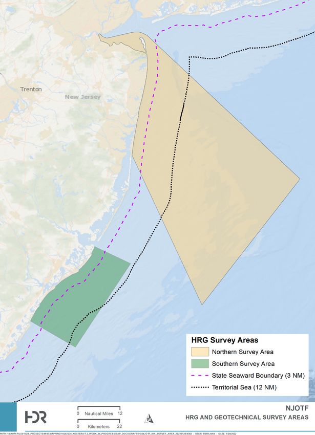
1.1 Project Description
NEETMA proposes to conduct reconnaissance level HRG&G surveys within the Project area to support the
proposed Project development (Figure 1-1). The survey area is divided in two and includes a southern survey
area (1,278 square kilometers [km2]), and a northern survey area (6,254 km2) for a total area of approximately
7,532 km2.
1.2 Survey Purpose and Need
The purpose of the HRG&G surveys is to support the siting and design of offshore Project facilities including
offshore platforms for converter stations and offshore submarine transmission cables.
1Figure 1-1. Proposed Survey Areas for the NJOTF Project HRG&G Surveys.
21.3 HRG Survey Activities
1.3.1 Regulatory Criteria
The MMPA defines two levels of marine mammal incidental harassment: Level A and Level B. Level A
harassment is defined in the MMPA as having the potential to injure a marine mammal or marine mammal
stock in the wild. Level B harassment is defined in the MMPA as having the potential to disturb a marine
mammal or marine mammal stock in the wild by causing disruption of behavioral patterns, including, but not
limited to, migration, breathing, nursing, breeding, feeding, or sheltering but which does not have the potential
to injure a marine mammal or marine mammal stock in the wild. However, distinct noise levels are not defined
in the MMPA as causing Level A or B takes.
1.3.2 Marine Mammal Functional Hearing Groups
Different species groups of marine mammals tend to hear with greater sensitivity at different ranges of
frequencies. The functional hearing ranges of marine mammals are summarized in Table 1-1. NMFS and the
Bureau of Ocean Energy Management (BOEM) have advised that HRG survey equipment that operates at
frequencies below 180 kilohertz (kHz) have the potential to harass marine mammals. Frequencies above 180
kHz are generally outside of the hearing ranges of marine mammals. See Section 1.3.3 for details on proposed
HRG survey equipment.
Table 1-1. Marine Mammal Hearing Groups.
Hearing Group Functional Hearing Range
Low-frequency (LF) cetaceans (baleen whales) 7 Hz to 35 kHz
Mid-frequency (MF) cetaceans (dolphins, toothed whales) 150 Hz to 160 kHz
High-frequency (HF) cetaceans (harbor porpoises) 275 Hz to 160 kHz
Phocid pinnipeds (PW) (underwater) (true seals) 50 Hz to 86 kHz
Source: NMFS 2018
The 2018 revised technical guidance from NMFS on assessing the effects of anthropogenic sound on marine
mammals characterizes the acoustic criteria that may cause a Level A take or Level B take or cause a change
in the acoustic hearing threshold of marine mammals. Acoustic thresholds refer to the levels of sound that, if
exceeded, will likely result in temporary or permanent changes in marine mammal hearing sensitivity. NMFS
categorizes these changes in hearing sensitivity into two categories, temporary threshold shifts (TTS) and
permanent threshold shifts (PTS) (Table 1-3). NMFS (2018) characterizes Level A harassment as exposure to
high noise levels and the onset of PTS. The threshold for Level B harassment has been defined by NMFS as
160 decibel root mean squared sound pressure level (dBrms) for impulsive noise (e.g., impact pile driving,
sparkers, boomers) and 120 dBrms for continuous noise (e.g., vibratory pile driving, drilling).
The weighted criteria 1 for acoustic exposure to cause PTS and TTS are presented in Table 1-2.
1
As stated in NMFS (2018), auditory weighting functions best reflect an animal’s ability to hear a sound (and do not
necessarily reflect how an animal will perceive and behaviorally react to that sound). To reflect higher hearing sensitivity at
particular frequencies, sounds are often weighted. Auditory weighting functions have been proposed for marine mammals,
specifically associated with PTS onset thresholds expressed in the weighted SELcum metric, which take into account what is
known about marine mammal hearing (Southall et al. 2007; Erbe et al. 2016).
3Table 1-2. Weighted PTS and TTS Onset Thresholds for Marine Mammals.
PTS Onset TTS Onset
Hearing Group
Impulsive1 Non-Impulsive Impulsive1 Non-Impulsive
LF cetaceans 219 dBpeak 199 dB SELcum 213 dBpeak 179 dB SELcum
183 dB SELcum 168 dB SELcum
MF cetaceans 230 dBpeak 198 dB SELcum 224 dBpeak 178 dB SELcum
185 dB SELcum 170 dB SELcum
HF cetaceans 202 dBpeak 173 dB SELcum 196 dBpeak 153 dB SELcum
155 dB SELcum 140 dB SELcum
PW 218 dBpeak 201 dB SELcum 212 dBpeak 181 dB SELcum
188 dB SELcum 170 dB SELcum
1
As dual metrics, NMFS considers onset of PTS to have occurred when either one of the two metrics presented (dBpeak or SELcum)
is exceeded.
Source: NMFS 2018
Notes – decibel peak sound pressure level (dBpeak); cumulative sound exposure level (SELcum)
1.3.3 HRG Survey Equipment
HRG surveys will be conducted within the survey areas described in Section 1.1 above. The HRG survey
equipment is anticipated to be identical or similar to that used for site characterization for offshore wind
development projects in the western North Atlantic Outer Continental Shelf (OCS), as previously approved by
NMFS and BOEM (87 FR 806; 86 FR 40469; 86 FR 33664; 86 FR 26465). NEETMA has evaluated the HRG
survey equipment utilized for other NMFS-issued IHAs for similar projects performed in the same region and
presents a list of representative HRG survey equipment in Table 1-3. It should be noted that the exact survey
equipment has not yet been determined and will be determined through the survey contracting process. Actual
survey equipment to be used will be determined by the survey contractor and availability of vessels and
equipment, as well as the data collection requirements and final survey design. Proposed representative
equipment that is used in the acoustic analysis of this application includes non-parametric shallow sub-bottom
profilers (SBPs; non-impulsive, mobile, intermittent sound source types; CHIRP Sonar), medium SBPs
(impulsive, mobile sound source types; sparkers and boomers), parametric SBPs, ultra-short baseline (USBL)
positioning and global acoustic positioning systems (GAPS), multibeam echosounders (MBES), and sidescan
sonar. Survey equipment will be deployed as mounted to or towed behind vessels of 15 to 80 m in length and
traveling at survey speeds of approximately 4 nm per hour (knots, 7.4 km per hour).
Each type of HRG survey equipment has a designated purpose and used together they can provide a detailed
characterization of the survey areas needed to inform Project development and regulatory requirements.
Representative HRG survey equipment is briefly described below.
• Shallow Penetration Sub-bottom Profilers (SBPs; Compressed High- Intensity Radiated Pulses
[CHIRPs]) to map the near-surface stratigraphy (top 0 to 5 m (0 to 16 ft) of sediment below seabed). A
CHIRP system emits sonar pulses that increase in frequency over time. The pulse length frequency
range can be adjusted to meet project variables. These are typically mounted on the hull of the vessel
or from a side pole.
4• Medium penetration SBPs (Boomers) to map deeper subsurface stratigraphy as needed. A boomer is
a broad-band sound source operating in the 3.5 Hz to 10 kHz frequency range. This system is typically
mounted on a sled and towed behind the vessel.
• Medium penetration SBPs (Sparkers) to map deeper subsurface stratigraphy as needed. A sparker
creates acoustic pulses from 50 Hz to 4 kHz omni-directionally from the source that can penetrate
several hundred meters into the seafloor. These are typically towed behind the vessel with adjacent
hydrophone arrays to receive the return signals.
• Parametric SBPs, also called sediment echosounders, for providing high density data in sub-bottom
profiles that are typically required for cable routes, very shallow water, and archaeological surveys.
These are typically mounted on the hull of the vessel or from a side pole.
• Ultra-short Baseline (USBL) Positioning and Global Acoustic Positioning System (GAPS) to provide
high accuracy ranges to track the positions of other HRG equipment by measuring the time between
the acoustic pulses transmitted by the vessel transceiver and the equipment transponder necessary to
produce the acoustic profile. It is a two-component system with a hull or pole mounted transceiver and
one to several transponders either on the seabed or on the equipment.
• Multibeam echosounder (MBES) to determine water depths and general bottom topography. MBES
sonar systems project sonar pulses in several angled beams from a transducer mounted to a ship's
hull. The beams radiate out from the transducer in a fan-shaped pattern orthogonally to the ship's
direction.
• Seafloor imaging (sidescan sonar) for seabed sediment classification purposes, to identify natural and
man-made acoustic targets resting on the bottom as well as any anomalous features. The sonar
device emits conical or fan-shaped pulses down toward the seafloor in multiple beams at a wide angle,
perpendicular to the path of the sensor through the water. The acoustic return of the pulses is recorded
in a series of cross-track slices, which can be joined to form an image of the sea bottom within the
swath of the beam. They are typically towed beside or behind the vessel or from an autonomous
vehicle.
Based on the representative equipment discussed above, the shallow and medium SBPs have the potential to
harass marine mammals. Equipment operating outside of marine mammal hearing ranges above 180 kHz
(MBES and sidescan sonar) are not discussed further in this application as they do not have the potential to
affect marine mammals occurring in the survey areas. Additionally, parametric SBPs operate at high
frequencies with narrow bandwidths, which may result in Level A and B harassment isopleth distances less
than 4 meters (m). Harassment exposure is therefore not reasonably expected from this source. USBLs are
also not expected to result in Level A or B harassment due to their functionality and source characteristics (86
FR 8490).
Table 1-3 provides a list of representative HRG survey equipment that has the potential to result in Level A or B
take of marine mammals and is used to assess take in this application (Section 6).
5Table 1-3. Representative HRG Survey Equipment.
CF = Crocker and Pulse
Operating
Fratantonio (2016) SLrms (dB re 1 SL0-pk (dB re 1 duration Repetition Beamwidth
Equipment Type frequency
MAN = μPa m) μPa m) (width) rate (Hz) (degrees)
(kHZ)
manufacturer (millisecond)
Non-parametric shallow penetration SBPs (non-impulsive)
2-16
ET 216 (2000DS or
MAN 195 - 20 6 24
3200 top unit) 2-8
ET 424 CF 4–24 176 - 3.4 2 71
ET 512 CF 0.7–12 179 - 9 8 80
GeoPulse 5430A MAN 2–17 196 - 50 10 55
Teledyne Benthos
MAN 2–7 197 - 60 15 100
Chirp III - TTV 170
Medium penetration SBPs (impulsive)
AA, Dura-spark UHD
CF 0.3–1.2 203 211 1.1 4 Omni
(400 tips, 500 J) 1
GeoMarine Geo Spark
CF 0.05-3 203 213 3.4 1 Omni
2000 (400 tip) 1,2
AA, triple plate S-
CF 0.1–5 205 211 0.6 4 80
Boom (700–1,000 J) 3
- = not applicable; μPa = micropascal; AA = Applied Acoustics; dB = decibel; ET = EdgeTech; J = joule; Omni = omnidirectional source; re = referenced to; SL = source
level; 0-PK = zero-to-peak; RMS = root mean squared; UHD = ultra-high definition.
1
The Dura-spark measurements and specifications provided in Crocker and Fratantonio (2016) were used for all sparker systems proposed for the survey. These include
variants of the Dura-spark sparker system and various configurations of the GeoMarine Geo-Source sparker system. The data provided in Crocker and Fratantonio (2016)
represent the most applicable data for similar sparker systems with comparable operating methods and settings when manufacturer or other reliable measurements are not
available.
2
GeoMarine Geo Spark 2000 (400 tips) information provided in 86 FR 40469 (Vineyard Wind 1 Marine Site Characterization Survey, 2021)
3
Crocker and Fratantonio (2016) provide S-Boom measurements using two different power sources (CSP–D700 and CSP–N). The CSP–D700 power source was used in
the 700 J measurements but not in the 1,000 J measurements. The CSP–N source was measured for both 700 J and 1,000 J operations but resulted in a lower SL;
therefore, the single maximum SL value was used for both operational levels of the S-Boom.
6Because the HRG survey equipment to be used is anticipated to be identical or similar to HRG survey
equipment used for other offshore projects, the Level A and B isopleths (distances to the Level A and B
thresholds) in Table 1-4 were obtained from both the South Fork Wind issued IHA (87 FR 806) and the
Vineyard Wind 1 issued IHA (86 FR 40469).
Table 1-4. Level A and B Harassment Isopleths by Representative HRG Survey Equipment Type.
Level A Harassment Isopleths (m) Level B
HRG Survey
LF Cetaceans MF Cetaceans HF Cetaceans HF Cetaceans Harassment
Equipment Type PW (SELcum)
(SELcum) (SELcum) (SELcum) (SPL0-pk) Isopleths (m)
Shallow SBPs
ET 216 CHIRPthreatened or endangered under the Endangered Species Act (ESA) (Table 4-1). Additionally, the fin whale
(Balaenoptera physalus), sei whale (Balaenoptera borealis), blue whale (Balaenoptera musculus), North
Atlantic right whale (Eubalaena glacialis), sperm whale (Physeter macrocephalus), and humpback whale
(Megaptera novaeangliae) are listed as Endangered by the states of New York and New Jersey and the harbor
porpoise (Phocoena phocoena) is considered a species of special concern as defined in Section 182.2(i) of
6NYCRR Part 182 by the state of New York (Table 3-1).
Table 3-1 summarizes the marine mammal species known to occur on the western North Atlantic OCS,
including the relative and seasonal occurrences for each species within the survey area. The table also
includes each species’ conservation status, including the designation as a strategic or non-strategic stock, as
defined by the MMPA (NMFS 2021b). A strategic stock is defined by the MMPA as marine mammal stock that
meets one or more of the following criteria: the population experiences a level of human-caused mortality that
exceeds the potential biological removal (PBR) level; the population is declining and is likely to be listed as a
threatened species under the ESA within the foreseeable future, based on the best available information; or the
population is listed as a threatened marine mammal species under the ESA or is designated as depleted under
the MMPA. A non-strategic stock is defined as any marine mammal stock that does not meet the strategic
stock criteria. The occurrence of the 39 species of marine mammals that may occur or are expected or likely to
occur in or transit near the survey area is based on the following criteria and/or the Mid-Atlantic Regional
Council on the Ocean (MARCO) and Northeast Regional Ocean Council (NROC) data portals habitat models
(i.e., Cadmus and CBI Catalyzing Collaboration 2020; MARCO 2021; NROC 2021) for the survey area and for
species available in the model analyses:
• Common – occurring consistently in moderate to large numbers.
• Regular – occurring regularly, inhabitants at least seasonally and have been documented within the
survey area.
• Uncommon – occurring in low numbers or on an irregular basis.
• Rare – records for some years but limited.
• Not expected – range includes the survey area but due to habitat preferences and distribution
information, species are not expected to occur in the survey area although records may exist for
adjacent waters.
8Table 3-1. Marine Mammals Known to Occur in the Western North Atlantic Outer Continental Shelf.
ESA/ MMPA
Common Name Status; NJ NY Stock Relative Occurrence in
Stock Strategic Habitat Preference
(Scientific Name) Status Status Abundance the Project Area
(Y or N)
Mysticetes
North Atlantic right whale W. North
ESA; E/D (Y) E E 368 Coastal to continental shelf Regular
(Eubalaena glacialis) Atlantic
Humpback whale MMPA; NL
Gulf of Maine E E 1,396 Coastal to continental shelf Common
(Megaptera novaeangliae) (N)
Fin whale
W. North
(Balaenoptera physalus ESA; E/D (Y) E E 6,802 Coastal to continental shelf Regular
Atlantic
physalus)
Sei whale
(Balaenoptera borealis Nova Scotia ESA; E/D (Y) E E 6,292 Continental shelf Uncommon
borealis)
Minke whale Canadian East MMPA; NL
N/A N/A 21,968 Continental shelf Regular
(Balaenoptera acutorostrata) Coast (N)
Blue whale W. North Unknown (402 Deep water beyond the
ESA; E/D (Y) E E Rare
(Balaenoptera musculus) Atlantic min) continental shelf
Odontocetes
Sperm whale Continental shelf break and
North Atlantic ESA; E E E 4,349 Uncommon
(Physeter macrocephalus) offshore
Dwarf and pygmy sperm
whale W. North MMPA; NL;
N/A N/A 7,750 Offshore Rare
(Kogia sima and Kogia Atlantic (N)
breviceps)
Risso’s dolphin W. North MMPA; NL
N/A N/A 35,215 Offshore Common
(Grampus griseus) Atlantic (N)
Long-finned pilot whale W. North MMPA; NL
N/A N/A 39,215 Continental shelf Common
(Globicephala melas) Atlantic (N)
9ESA/ MMPA
Common Name Status; NJ NY Stock Relative Occurrence in
Stock Strategic Habitat Preference
(Scientific Name) Status Status Abundance the Project Area
(Y or N)
Short-finned pilot whale
W. North MMPA; NL
(Globicephala N/A N/A 28,924 Offshore Uncommon
Atlantic (N)
macrorhynchus)
Atlantic white-sided dolphin W. North MMPA; NL
N/A N/A 93,233 Continental shelf Uncommon
(Lagenorhynchus acutus) Atlantic (N)
Common dolphin W. North MMPA; NL
N/A N/A 172,974 Coastal and offshore Common
(Delphinus delphis delphis) Atlantic (N)
W. North
MMPA; NL
Atlantic, N/A N/A 62,851 Offshore Uncommon
(N)
Offshore
Common bottlenose dolphin
W. North
(Tursiops truncatus
Atlantic,
truncatus) MMPA; NL/D; Coastal, bays, inlets, and
Northern N/A N/A 6,639 Common
Y offshore
Coastal
Migratory
Atlantic spotted dolphin W. North MMPA; NL Deep slope water and
N/A N/A 39,921 Uncommon
(Stenella frontalis) Atlantic (N) offshore
Harbor porpoise
Gulf of Maine/ MMPA; NL
(Phocoena phocoena N/A SC 95,543 Coastal to continental shelf Uncommon
Bay of Fundy (N)
phocoena)
Cuvier's beaked whale W. North MMPA; NL
N/A N/A 5,744 DOW Rare
(Ziphius cavirostris) Atlantic (N)
Mesoplodont
beaked whales (Blainville’s,
Gervais’, True’s, and
W. North MMPA; NL/D
Sowerby’s) N/A N/A 10,107 DOW Rare
Atlantic (N)
(Mesoplodon densirostris, M.
europaeus, M. mirus, and M.
bidens)
10ESA/ MMPA
Common Name Status; NJ NY Stock Relative Occurrence in
Stock Strategic Habitat Preference
(Scientific Name) Status Status Abundance the Project Area
(Y or N)
Striped dolphin W. North MMPA; NL
N/A N/A 67,036 Offshore Rare
(Stenella coeruleoalba) Atlantic (N)
Clymene dolphin W. North MMPA; NL
N/A N/A 4,237 DOW Not Expected
(Stenella clymene) Atlantic (N)
Fraser’s dolphin W. North MMPA; NL
N/A N/A Unknown DOW Rare
(Lagenodelphis hosei) Atlantic (N)
Pantropical spotted dolphin W. North MMPA; NL Deep slope water and
N/A N/A 6,593 Rare
(Stenella attenuata) Atlantic (N) offshore
Rough-toothed dolphin W. North MMPA; NL
N/A N/A 136 DOW Rare
(Steno bredanensis) Atlantic (N)
Spinner dolphin W. North MMPA; NL
N/A N/A 4,102 DOW Rare
(Stenella longirostris) Atlantic (N)
White-beaked dolphin W. North MMPA; NL
N/A N/A 536,016 Continental shelf Rare
(Lagenorhynchus albirostris) Atlantic (N)
Continental shelf and rise;
Killer whale W. North MMPA; NL
N/A N/A Unknown Open sea and offshore Rare
(Orcinus orca) Atlantic (N)
waters
Pygmy killer whale W. North MMPA; NL
N/A N/A Unknown DOW Not Expected
(Feresa attenuata) Atlantic (N)
False killer whale W. North MMPA; NL
N/A N/A 1,791 DOW Rare
(Pseudorca crassidens) Atlantic (N)
Northern bottlenose whale W. North MMPA; NL
N/A N/A Unknown DOW Not Expected
(Hyperoodon ampullatus) Atlantic (N)
Melon-headed whale W. North MMPA; NL
N/A N/A Unknown DOW Not Expected
(Peponocephala electra) Atlantic (N)
11ESA/ MMPA
Common Name Status; NJ NY Stock Relative Occurrence in
Stock Strategic Habitat Preference
(Scientific Name) Status Status Abundance the Project Area
(Y or N)
Pinnipeds
Coastal, bays, estuaries,
Harbor seal W. North MMPA; NL inlets, Great Bay, Barnegat
N/A N/A 61,336 Regular
(Phoca vitulina vitulina) Atlantic (N) Inlet/Barnegat Lighthouse,
Sandy Hook
Gray seal
W. North MMPA; NL Coastal and continental shelf
(Halichoerus grypus N/A N/A 27,300 Regular
Atlantic (N) waters, Muskeget Island
atlantica)
Harp seal W. North MMPA; NL Continental shelf with pack
N/A N/A 7.6 million Rare
(Pagophilus groenlandicus) Atlantic (N) ice
Hooded seal W. North MMPA; NL DOW at edge of continental
N/A N/A Unknown Rare
(Phoca groenlandica) Atlantic (N) shelf with pack ice
Sirenians
Florida manatee Nearshore: marine, brackish,
(Trichechus manatus - ESA; T/D (Y) N/A N/A ~6,300 and freshwater systems in Not Expected
latirostris) coastal and riverine areas
Notes: D = depleted; DOW = deep ocean water; E = Endangered; ESA = Endangered Species Act; M / SI = Mortality / Serious Injury; min = minimum; MMPA = Marine
Mammal Protection Act; N/A = Not applicable; NJ = New Jersey; NL = not listed; NY = New York; PBR = Potential Biological Removal; SC = Special Concern; T =
Threatened; W. = Western.
Sources: Kenney and Vigness-Raposa 2010; Whitt et al. 2013, 2015; Roberts et al. 2016a, 2016b, 2017, 2018, 2020, 2021a, 2021b; Muirhead et al. 2018; Smultea
Environmental Sciences 2018; Milne 2019; RPS 2020; Hayes et al. 2020, 2021; New York State Department of Environmental Conservation 2021; New Jersey Department
of Environmental Protection 2021; USFWS 2021; Pettis et al. 2021; Pace 2021; NMFS 2021b.
124. Affected Species Status and Distribution
The species with likelihood of occurrence identified as not expected or rare in the survey area (Table 3-1) are
not anticipated to be present in or near the survey area at densities that make them vulnerable to impact from
project activities; therefore, they are not carried forward in the following sections. The following 16 potentially
affected species are those that have a regular, common, or uncommon relative occurrence in the survey areas,
or have a very wide distribution with limited distribution or abundance details, so it is possible they could occur
within the survey area. Status, stock identification, distribution, and occurrence of these marine mammal
species are listed in Table 3-1 and each species and stock is discussed in the following sections. The 16
species assessed for take estimates in this application include:
1. North Atlantic right whale,
2. Fin whale,
3. Sei whale,
4. Sperm whale,
5. Humpback whale,
6. Common minke whale,
7. Risso's dolphin,
8. Short-finned pilot whale
9. Long-finned pilot whale
10. Atlantic white-sided dolphin,
11. Common dolphin,
12. Common bottlenose dolphin,
13. Atlantic spotted dolphin,
14. Harbor porpoise,
15. Harbor seal, and
16. Gray seal.
4.1 Threatened and Endangered Marine Mammals
4.1.1 North Atlantic Right Whale (Eubalaena glacialis) – Endangered
The North Atlantic right whale was listed as a federally endangered species in 1970 and is considered one of
the most critically endangered large whale species in the world (Clapham et al. 1999; Weinrich et al. 2000;
Hayes et al. 2021; Quintana-Rizzo et al. 2021; 71 FR 77704; 73 FR 12024). The North Atlantic right whale has
seen a nominal two percent recovery rate since it was listed as a protected species (Waring et al. 2015), which
is much lower than the recovery rate of seven to eight percent documented for the Southern right whale distinct
population segment (DPS) in the Southern Hemisphere (Knowlton and Kraus 2001). Right whales are
considered grazers as they swim slowly with their mouths open. They are the slowest swimming whales and
can only reach speeds up to 10 miles (mi) (16 km) per hour. They typically dive between 80 and 175 m and
stay submerged for typically 10 to 15 minutes, following their prey below the surface (Baumgartner and Mate
2003). North Atlantic right whale hearing is in the low-frequency range (Southall et al. 2007, 2019).
The North Atlantic right whale is a migratory species that moves annually between high-latitude feeding
grounds and low-latitude calving and breeding grounds. The present range of the western North Atlantic right
whale population extends from the southeastern U.S., which is utilized for wintering and calving, to summer
feeding and nursery grounds in New England, the Bay of Fundy, and the Gulf of St. Lawrence (Kenney 2017;
Hayes et al. 2021). The winter distribution of North Atlantic right whales is largely unknown, although offshore
surveys have reported one to 13 detections annually from 1996 to 2001 in northeastern Florida and
southeastern Georgia (Hayes et al. 2021). A few events of North Atlantic right whale calving have been
documented from shallow coastal areas and bays (Kenney 2017). Some evidence provided through acoustic
13monitoring suggests that not all individuals of the population participate in annual migrations, with a continuous
presence of North Atlantic right whales occupying their entire habitat range throughout the year, particularly
north of Cape Hatteras (Davis et al. 2017). These data also recognize changes in population distribution
throughout the right whale habitat range that could be due to environmental or anthropogenic effects, a
response to short-term changes in the environment, or a longer-term shift in the right whale distribution cycle.
For example, since 2010, there has been an apparent shift in North Atlantic right whale habitat use, with
decreasing use of the Great South Channel and increasing use of Cape Cod Bay, the Mid-Atlantic Bight, and
the Gulf of St. Lawrence (Whitt et al. 2013; Davis et al. 2017; Mayo et al. 2018; Quintana-Rizzo et al. 2021).
Three critical habitat areas were designated for this species in 1994: (1) the Cape Cod Bay/Stellwagen Bank,
(2) the Great South Channel, and (3) waters adjacent to the coasts of Georgia and the east coast of Florida (59
FR 28805). In 2016, NMFS issued a final rule to replace the critical habitat for right whales in the North Atlantic
with two new areas. The areas being designated as critical habitat contain approximately 29,763 square nm of
marine habitat in the Gulf of Maine and Georges Bank region (Unit 1) and off the Southeast U.S. coast (Unit 2)
(81 FR 4837). Unit 1 contains approximately 29,763 square nautical miles (nm2) of marine habitat in the Gulf of
Maine and Georges Bank region. No critical habitat for the North Atlantic right whale occurs in the survey area;
however, two Seasonal Management Areas (SMA) fall within the survey area.
Observations in December 2008 noted congregations of more than 40 individual North Atlantic right whales in
the Jordan Basin area of the Gulf of Maine, leading researchers to believe this may be a wintering ground
(NOAA Fisheries 2008). A North Atlantic right whale satellite tracking study within the northeast Atlantic
(Baumgartner and Mate 2005) reported that this species often visited waters exhibiting low bottom water
temperatures, high surface salinity, and high surface stratification, most likely for higher food densities. North
Atlantic right whales may be found in feeding grounds within New England waters between February and May,
with peak abundance in late March (NOAA 2005). While in New England, North Atlantic right whales feed
mostly on copepods belonging to the Calanus and Pseudocalanus genera (Hayes et al. 2021).
The North Atlantic right whale was the first species targeted during commercial whaling operations and was the
first species to be greatly depleted because of whaling operations (Kenney 2017). North Atlantic right whales
were hunted in southern New England until the early twentieth century. Shore-based whaling in Long Island,
New York, involved catches of North Atlantic right whales year-round, with peak catches in spring during the
northbound migration from calving grounds off the southeastern U.S. to feeding grounds in the Gulf of Maine
(Kenney and Vigness-Raposa 2010).
Abundance estimates for the North Atlantic right whale population vary. From the 2003 U.S. Atlantic and Gulf of
Mexico Marine Mammal Stock Assessments, there were only 291 North Atlantic right whales in existence,
which is fewer than what was reported in the Northern Right Whale Recovery Plan written in 1991 (NMFS
1991a; Waring et al. 2004). Pre-exploitation numbers are estimated at around 1,000 individuals. When the right
whale was finally protected in the 1930s, the North Atlantic right whale population was roughly 100 individuals
(Waring et al. 2004). In 2015, the Western North Atlantic population was estimated to be at least 476
individuals (Waring et al. 2016). That population size estimate decreased to 440 individuals in 2017 (Hayes et
al. 2017), with a median estimate of abundance of 451 in 2018 (Hayes et al. 2019). Additional information
provided by Pace et al. (2017) confirms that the probability that the North Atlantic right whale population has
declined since 2010 is 99.99 percent. The 2020 population estimate for the North Atlantic right whale was 412
individuals identified using photo-identification techniques (Pace et al. 2017; Hayes et al. 2021). Based on the
North Atlantic Right Whale Consortium 2020 Annual Report Card, the best estimate for the end of 2019 is 356
North Atlantic right whales (Pettis et al. 2021). As of October 2021, the North Atlantic Right Whale Consortium
announced that the population had dropped to 336 individuals in 2020, the lowest estimate for the species in
the last 20 years (New England Aquarium 2021; North Atlantic Right Whale Consortium 2021). However, using
the Pace et al. (2017) state–space mark–recapture estimates, the most recent estimate is 368 individuals as of
14January 2019 (Pace 2021; NMFS 2021b; Pettis et al. 2021). The current draft 2021 Stock Assessment Report
estimates an abundance of 368 individuals, which is a decrease from 412 individuals as estimated for 2020
(NMFS 2021b; Hayes et al. 2021). This estimate is based on an updated published state-space model of the
sighting histories of individual whales identified using photo-identification techniques (Pace et al. 2017, Pace
2021) and reflects the impacts of the ongoing Unusual Mortality Event (UME) declared in 2017 for the species
(NOAA Fisheries 2021a). Data indicate that the number of adult females dropped from 200 in 2010 down to
186 in 2015, while males dropped from 283 to 272 in the same timeframe. Also cause for concern is the
confirmed mortality of 14 individuals in 2017 alone (Pace et al. 2017).
The most recent stock assessment report (NMFS 2021b) noted that studies by van der Hoop et al. (2015) have
concluded large whale vessel strike mortalities decreased inside active SMAs but have increased outside
inactive SMAs. In 2017, there were 17 North Atlantic right whale mortalities (Daoust et al. 2017). This number
exceeds the largest estimated mortality rate during the past 25 years. Further, despite high survey effort, only 5
and 0 calves were detected in 2017 and 2018, respectively. An UME for the species was declared in June 2017
and since then, 34 North Atlantic right whales have stranded dead (21 in Canada; 12 in the U.S.) and 15 live,
free-swimming, non-stranded whales have been documented with serious injuries from entanglements or
vessel strikes (NOAA Fisheries 2021a). The major cause of the UME is vessel strikes and gear entanglement.
North Atlantic right whales have been observed in or near waters south of New England during all four seasons
(New Jersey Department of Environmental Protection [NJDEP] 2010); however, they are most common in the
spring when they are migrating north and in the fall during their southbound migration (Kenney and Vigness-
Raposa 2010; Roberts et al. 2016). North Atlantic right whales were reported off New Jersey in all seasons
except summer during the 2008-2009 aerial- and vessel-based surveys (NJDEP 2010; Whitt et al. 2013, 2015).
They were observed in the spring 2014 aerial, the winter/spring 2015 aerial, the spring 2019 aerial Atlantic
Marine Assessment Program for Protected Species (AMAPPS) surveys (Northeast Fisheries Science Center
[NEFSC] and Southeast Fisheries Science Center [SEFSC] 2014, 2015, 2020). A single North Atlantic right
whale occurred in the project area during the Geotechnical 1A Survey in winter 2017-2018 (Smultea
Environmental Sciences 2018). Three North Atlantic right whale sightings within the project area were reported
between 13 and 14 December 2018 (NOAA Fisheries 2019). During the New York-New Jersey Bight Whale
Monitoring Aerial Surveys March 2017 – February 2018, 13 individual North Atlantic right whales were
observed during winter (two whales in January and one whale in February), spring (three whales in March and
five whales in April) and two whales during fall (November) (Tetra Tech and LGL 2019).
Passive Acoustic Monitoring (PAM) of North Atlantic right whales has been conducted in and near the survey
area (Whitt et al. 2013; Davis et al. 2017; Woods Hole Oceanographic Institution [WHOI] 2021; WhaleMap
2021) and have demonstrated their year-round presence off New Jersey (Whitt et al. 2013, 2015). A digital
acoustic monitoring (DMON) moored buoy was deployed 20 miles southeast of Atlantic City, New Jersey, on 30
July 2020, to monitor the presence of baleen whales in near real-time by automatically detecting and identifying
their calls (WHOI 2021). North Atlantic right whales have been detected off New Jersey during the fall, winter,
and spring with the last detection in early March (WHOI 2021). From November to December 2020, a Slocum
G3 glider was deployed in the survey area off Atlantic City and North Atlantic right whales were detected during
both months (WHOI 2021). During summer and fall 2020, Slocum G3 gliders were deployed in the survey area
off Atlantic City and North Atlantic right whales were not detected during the months of July, August, or October
(WHOI 2021).
4.1.2 Fin Whale (Balaenoptera physalus) – Endangered
The fin whale was listed as federally endangered in 1970 and is considered a strategic stock although no
critical habitat is designated. The fin whale is MMPA depleted throughout its range. NMFS initiated a 5-year
review of the fin whale in January 2018 to determine whether a reclassification or delisting may be warranted
15(NMFS 2019; 83 FR 4032). In February 2019, the review indicated that, based on the most reliable available
scientific and commercial information, the fin whale should be downlisted from endangered to threatened;
however, this downlisting has not occurred and is recommended for future action (NMFS 2019). A final
recovery plan was written for fin whales in 2010 (NMFS 2010).
Fin whales’ range in the North Atlantic extends from the Gulf of Mexico, Caribbean Sea, and Mediterranean
Sea in the south to Greenland, Iceland, and Norway in the north (Jonsgård 1966; Gambell 1985). They are the
most sighted large whales in continental shelf waters from the mid-Atlantic coast of the U.S. to Nova Scotia
(Sergeant 1977; Sutcliffe and Brodie 1977; Cetacean and Turtle Assessment Program (CeTAP) 1982; Hain et
al. 1992; Waring et al. 2008). Fin whales, much like humpback whales, seem to exhibit site fidelity (Kenney and
Vigness-Raposa 2010; Hayes et al. 2021). However, fin whales’ habitat use has shifted in the southern Gulf of
Maine, most likely due to changes in the abundance of sand lance and herring, both of which are major prey
species along with squid, krill, and copepods (Kenney and Vigness-Raposa 2010). While fin whales typically
feed in the Gulf of Maine and the waters surrounding New England, mating and calving (and general wintering)
areas are still largely unknown (Hayes et al. 2021).
The overall pattern of fin whale movement is complex, consisting of a less obvious north-south pattern of
migration than that of right and humpback whales. Based on acoustic recordings from hydrophone arrays,
Clark (1995) reported a general southward flow pattern of fin whales in the fall from the
Labrador/Newfoundland region, past Bermuda, and into the West Indies. The overall distribution may be based
on prey availability, as this species preys opportunistically on both invertebrates and fish (Watkins et al. 1987).
Fin whale abundance off the coast of the northeastern U.S. is highest between spring and fall, with some
individuals remaining during the winter (Hain et al. 1992). Past estimates of fin whale abundance conducted
between Georges Bank and the Gulf of St. Lawrence during the feeding season in August 2006 place the
western North Atlantic fin whale populations at 2,269 individuals (Waring et al. 2007). More recent estimates
indicate the western North Atlantic fin whale population is 6,802 individuals (Hayes et al. 2021). Fin whales are
the second largest living whale species on the planet (Kenney and Vigness-Raposa 2010). The gestation
period for fin whales is approximately 11 months and calf births occur between late fall and winter. Females
can give birth every two to three years. Their hearing is in the low-frequency range (Southall et al. 2007, 2019).
From 2008 to 2012, the minimum annual rate of mortality for the North Atlantic stock from anthropogenic
causes was approximately 3.35 per year (Waring et al. 2015) while from 2010 to 2014, this number has
increased to 3.8 (Hayes et al. 2017). The average annual observed and estimated mortality and injury for fin
whales is 1.8 for the years 2015 to 2019 (NMFS 2021b). There have not been any UMEs documented for fin
whales in the last three decades. Increase in ambient noise has also impacted fin whales, for whales in the
Mediterranean have demonstrated at least two different avoidance strategies after being disturbed by tracking
vessels (Jahoda et al. 2003). The most reliable abundance estimate available for the western North Atlantic fin
whale stock is 6,802 based on the 2016 NOAA shipboard and aerial surveys and the 2016 NEFSC and
Fisheries and Oceans Canada (DFO) surveys (Lawson and Gosselin 2018; NEFSC and SEFSC 2018;
Garrison 2020; Palka 2020; Hayes et al. 2021).
Fin whales are present in waters south of New England waters and may occur in the survey area during all four
seasons (NJDEP 2010). In spring, summer, and fall, the main center of their distribution is in the Great South
Channel area to the east of Cape Cod, which is a well-known feeding ground (Kenney and Winn 1986). Winter
is the season of lowest overall abundance, but they do not depart the area entirely. Fin whales are the most
common large whale encountered in continental shelf waters (Muirhead et al. 2018). They are the whales most
often encountered by local whale-watching operations in most years and are likely to occur in the vicinity of the
survey area. Fin whales were reported off New Jersey in all seasons during the 2008-2009 aerial- and vessel-
based surveys (NJDEP 2010; Whitt et al. 2015). Fin whales were observed in the survey area during the fall
2012 aerial, spring 2013 aerial, spring 2014 aerial, spring and summer 2017 aerial, winter 2018 aerial, spring
162019 aerial, and summer 2016 shipboard AMAPPS surveys (NEFSC and SEFSC 2012, 2013, 2014, 2016,
2018, 2019, 2020). Fin whales were recorded in the survey area during the summer 2017 HRG survey (Alpine
2017) and during the Geotechnical 1A Survey in winter 2017-2018 (Smultea Environmental Sciences 2018).
During the New York-New Jersey Bight Whale Monitoring Aerial Surveys March 2017 – February 2018, fin
whales were recorded in all four seasons and all months, except for April and June (Tetra Tech and LGL 2019).
Fin whales were reported off New Jersey during the Atlantic Shores 2020 Offshore Windfarm HRG survey from
April to August 2020 (RPS 2020). During Digital Aerial Baseline Surveys in the New York-New Jersey Bight, fin
whales were recorded off New Jersey in the summer and fall (Normandeau and APEM 2020).
PAM of fin whales has been conducted in and near the survey area (WHOI 2021). A DMON moored buoy was
deployed 20 miles southeast of Atlantic City, New Jersey, on 30 July 2020 to monitor the presence of baleen
whales in near real-time by automatically detecting and identifying their calls (WHOI 2021). Fin whales have
been detected almost daily during the months of October, November, January, February off New Jersey with
the last detection in early March (WHOI 2021). From November to December 2020, a Slocum G3 glider was
deployed in the survey area off Atlantic City and fin whales were detected during both months (WHOI 2021).
During summer and fall 2020, Slocum G3 gliders were deployed in the survey area off Atlantic City and fin
whales were not detected during the months of July or October but detected on one day in August (WHOI
2021).
4.1.3 Sei Whale (Balaenoptera borealis) – Endangered
The sei whale was listed as federally endangered in 1970 and a final recovery plan was published for the
species in 2011 (NOAA Fisheries 2011). The stock that resides in the U.S. Exclusive Economic Zone (EEZ) is
the Nova Scotian stock, which is highly migratory from the northeast U.S. to Newfoundland (Hayes et al. 2021).
Sei whales typically inhabit deeper offshore waters of the OCS (Hain et al. 1985; BOEM 2014). However, they
have been known to episodically enter shallow inshore waters (Payne et al. 1990; Flinn et al. 2002; Hayes et al.
2017). Of the other large whales, sei whales are the least abundant species in the survey area (Kraus et al.
2016). However, there is still a possibility that this species may be encountered during HRG surveys (Right
Whale Consortium 2014). The major prey of sei whales are copepods, in addition to small schooling fish and
squid (Flinn et al. 2002). Sei whales are generally sighted traveling in small groups (less than five individuals),
but it is not unusual for larger congregations to be found in feeding grounds (NOAA Fisheries 2018a). Their
hearing is in the low-frequency range (Southall et al. 2007, 2019).
The most recent estimate of abundance for the Nova Scotia stock of sei whales is 6,292 individuals based on
spatially- and temporally explicit density models derived from abundance survey data collected between 2010
and 2013 (Palka et al. 2017; Hayes et al. 2021). This is considered a low estimate as sei whales inhabit deep
offshore waters that have not been surveyed to a great extent. In addition, there is insufficient information to
determine population trends for the species. Sei whales migrate from south of Cape Cod to the eastern
Canadian coast in June and July and return in September and October (Waring et al. 2014, 2016). Sei whales
are most abundant in deep southern New England waters in summer and absent in winter (Waring et al. 2014,
2016; Roberts et al. 2016). No sei whales were recorded during Ecological Baseline Studies (EBS) surveys, but
a fin/sei whale (could not be identified to species) was documented in the waters off New Jersey during the
summer 2016 and 2017 AMAPPS surveys (NJDEP 2010; NEFSC and SEFSC 2016, 2018). During the New
York-New Jersey Bight Whale Monitoring Aerial Surveys March 2017 – February 2018, no sei whales were
confirmed to species (Tetra Tech and LGL 2019). A sighting of one sei whale was reported off New Jersey
during the Atlantic Shores 2020 Offshore Windfarm HRG survey from April to August 2020 (RPS 2020). During
Digital Aerial Baseline Surveys in the New York-New Jersey Bight, sei whales were recorded off New Jersey in
the spring (Normandeau and APEM 2020).
17You can also read