Environmental Assessment - Mt. Hough - South Park Proposed Trail System Project - Sierra Buttes Trail ...
←
→
Page content transcription
If your browser does not render page correctly, please read the page content below
United States
Department of
                Environmental Assessment
Agriculture

Forest
Service
                Mt. Hough - South Park
April 2013
                Proposed Trail System Project

                Mt. Hough Ranger District, Plumas National Forest
                Plumas County, California

                                                                For Information, contact: Gretchen Jehle
                                          Mt. Hough Ranger District, 36969 Highway 70, Quincy, CA 95971
                                                                                           530-283-7689
                                                              Project Website: http://1.usa.gov/13SkXSn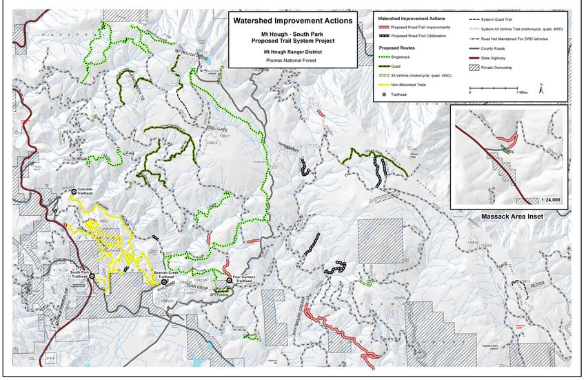
The U.S. Department of Agriculture (USDA) prohibits discrimination in all its programs and
activities on the basis of race, color, national origin, age, disability, and where applicable,
sex, marital status, familial status, parental status, religion, sexual orientation, genetic
information, political beliefs, reprisal, or because all or part of an individual’s income is
derived from any public assistance. (Not all prohibited bases apply to all programs.) Persons
with disabilities who require alternative means for communication of program information
(Braille, large print, audiotape, etc.) should contact USDA’s TARGET Center at 202-720-2600
(voice and TDD). To file a complaint of discrimination, write USDA, Director, Office of Civil
Rights, 1400 Independence Avenue, SW, Washington, DC 20250-9410 or call toll free (866)
632-9992 (voice). TDD users can contact USDA through local relay or the Federal relay at
(800) 877-8339 (TDD) or (866) 377-8642 (relay voice). USDA is an equal opportunity provider
and employer.
Environmental Assessment                                                     Mt. Hough – South Park Proposed Trail System Project

                                                      Table of Contents
SUMMARY ............................................................................................................................ iii
INTRODUCTION ..................................................................................................................... 1
  Document Structure.....................................................................................................................1
  Purpose and Need for Action .......................................................................................................1
  Proposed Action ...........................................................................................................................4
     Management Direction............................................................................................................5
     Project Location .......................................................................................................................6
  Decision Framework ....................................................................................................................6
  Public Involvement.......................................................................................................................6
  Issues ............................................................................................................................................7
ALTERNATIVES, INCLUDING THE PROPOSED ACTION ............................................................. 10
  Alternatives Considered in Detail ............................................................................................. 10
     Alternative A - The Proposed Action .................................................................................... 10
        1.     Trail Development ................................................................................................. 10
        2.     Designate the Cascade Trailhead Area as Day Use Only ....................................... 15
        3.     Trailhead Designation and Development .............................................................. 17
        4.     Treatment of Invasive Plants ................................................................................. 19
     Alternative B - No Action ...................................................................................................... 23
  Alternatives Considered but Eliminated from Detailed Study .................................................. 24
     Alternative C – Motorized Trail on Grizzly Ridge .................................................................. 24
     Alternative D – Allow Motorized Use on South Park Trails .................................................. 24
     Alternative E and F – Designation of Non-motorized trails for Single Uses: ........................ 25
        Designation of the Cascade Trail as Hiker Only ................................................................ 25
        Designation of Equestrian Only Trails in the South Park Area ......................................... 25
  Mitigations ................................................................................................................................ 26
AFFECTED ENVIRONMENT AND ENVIRONMENTAL CONSEQUENCES ...................................... 28
  Recreation ................................................................................................................................ 29
    Affected Environment........................................................................................................... 29
       Trails and Trailheads......................................................................................................... 29
       Visitor Use ........................................................................................................................ 30
       Use Conflict ...................................................................................................................... 31
       Recreation Opportunity Spectrum (ROS) ......................................................................... 32
    Environmental Consequences .............................................................................................. 33
       Alternative A (Proposed Action): Direct, Indirect, and Cumulative Impacts.................... 33
       Alternative B (No Action): Direct, Indirect, and Cumulative Impacts .............................. 39
  Watershed and Soil .................................................................................................................. 42
    Affected Environment and Analysis Framework .................................................................. 42
       Cumulative Watershed Effects–analysis methods & assumptions .................................. 43
    Environmental Consequences .............................................................................................. 44
       Alternative A (Proposed Action): Direct, Indirect, and Cumulative Impacts.................... 44
       Alternative B (No Action): Direct, Indirect, and Cumulative Impacts .............................. 47
    Compliance with the Forest Plan and Other Direction ......................................................... 48
       Clean Water Act................................................................................................................ 48
       Floodplain Management, Executive Order 11988 of May 24, 1977 ................................ 48
       Protection of Wetlands, Executive Order 11990 of May 24, 1977 .................................. 49
Mt. Hough – South Park Proposed Trail System Project                                                            Environmental Assessment

   Botanical Resources................................................................................................................... 49
      Affected Environment ........................................................................................................... 49
      Environmental Consequences ............................................................................................... 49
         Alternative A (Proposed Action): Direct, Indirect, and Cumulative Impacts .................... 49
         Alternative B (No Action): Direct, Indirect, and Cumulative Impacts ............................... 50
   Cultural Resources ..................................................................................................................... 51
      Affected Environment ........................................................................................................... 51
      Environmental Consequences ............................................................................................... 52
         Alternative A (Proposed Action): Direct, Indirect, and Cumulative Impacts .................... 52
         Alternative B (No Action): Direct, Indirect, and Cumulative Impacts ............................... 53
   Wildlife....................................................................................................................................... 54
      Affected Environment ........................................................................................................... 54
      Environmental Consequences ............................................................................................... 54
         Alternative A (Proposed Action): Direct, Indirect, and Cumulative Impacts .................... 54
         Alternative B (No Action): Direct, Indirect, and Cumulative Impacts ............................... 63
   Mining ....................................................................................................................................... 63
      Affected Environment ........................................................................................................... 63
      Environmental Consequences ............................................................................................... 63
         Alternative A (Proposed Action): Direct, Indirect, and Cumulative Impacts .................... 63
         Alternative B (No Action): Direct, Indirect, and Cumulative Impacts ............................... 64
   Fire, Fuels, and Air Quality......................................................................................................... 64
      Environmental Consequences ............................................................................................... 64
         Alternative A (Proposed Action): Direct, Indirect, and Cumulative Impacts .................... 64
         Alternative B (No Action): Direct, Indirect, and Cumulative Impacts ............................... 65
   Forest Vegetation ...................................................................................................................... 65
      Affected Environment ........................................................................................................... 65
      Environmental Consequences ............................................................................................... 65
         Alternative A (Proposed Action): Direct, Indirect, and Cumulative Impacts .................... 65
         Alternative B (No Action): Direct, Indirect, and Cumulative Impacts ............................... 65
REFERENCES ........................................................................................................................ 66
CONSULTATION AND COORDINATION .................................................................................. 69
APPENDIX A - Maps.............................................................................................................. 75
  Map of Proposed Herbicide Treatment Locations .................................................................... 75
  Map of Proposed Watershed Improvements ............................................................................ 76
APPENDIX B – Best Management Practices Applicable to this Assessment ............................. 75
APPENDIX C - Standard Management Requirements ............................................................. 77
Environmental Assessment                                           Mt. Hough – South Park Proposed Trail System Project

                                                    List of Tables
Table 1.     Miles of routes that would be available to various users after full
implementation of the MHSP Trails Project. ………………………………………………………………….ii
Table 2.        Miles of routes proposed for inclusion in the MHSP Trails Project ............... 11
Table 3.        Design Criteria for Trail Development ............................................................ 14
Table 4.        Design Criteria common to all ground-disturbing actions ............................. 15
Table 5.        Design Criteria for designating Cascade Trailhead area as day use only ....... 17
Table 6.        Design Criteria for Cascade Trailhead development ...................................... 17
Table 7.        Design Criteria for South Park Trailhead development.................................. 18
Table 8. Current management goals for known infestations of invasive plants on NFS
lands within project area .................................................................................................. 19
Table 9.        Proposed Treatments for Invasive plants by species ..................................... 20
Table 10.           Design Criteria for Invasive plant Treatments ............................................ 21
Table 11.           Design Criteria for herbicide use by resource ............................................ 22
Table 12.           Stream buffers for herbicide application .................................................... 23
Table 13.   Roads and trails proposed for obliteration and improvement to address
watershed concerns in the project area ........................................................................... 28
Table 14.           Plumas National Forest visits by participation and main activity ............... 30
Table 15.    Change in the combined density of roads and motorized trails in the
Mt. Hough Game Refuge and the MHSP Trails Project area that would be caused by the
proposed action ................................................................................................................ 57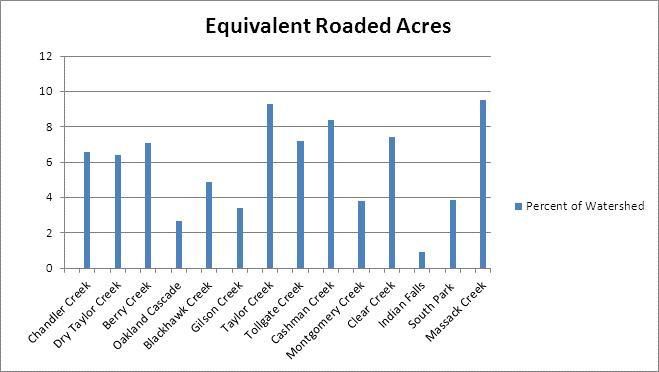
Mt. Hough – South Park Proposed Trail System Project Environmental Assessment
List of Figures
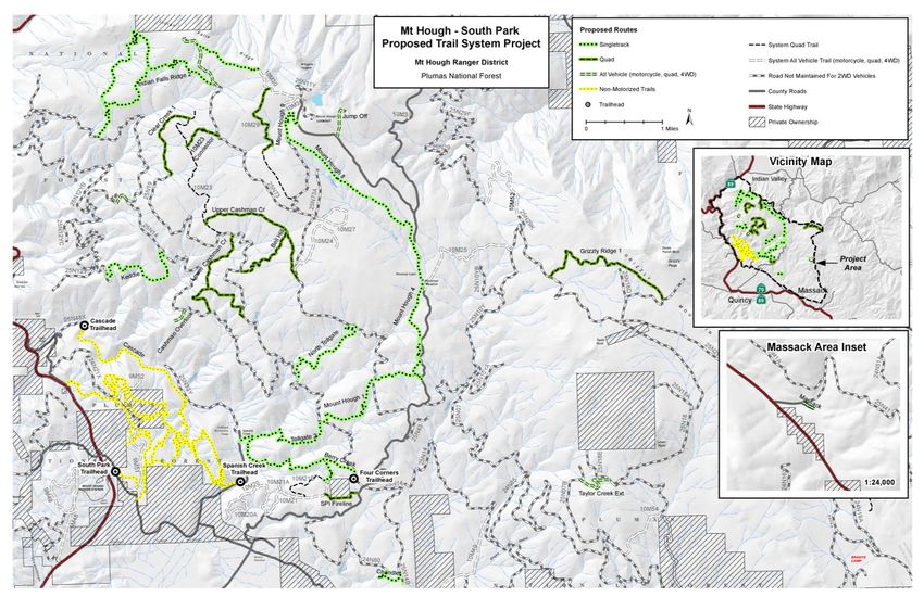
Figure 1. MHSP Trails Project map, including all of the motorized and non-motorized
routes proposed in Alternative A – the Proposed Action................................................. 12
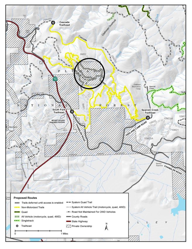
Figure 2. Map of the proposed South Park non-motorized trail system showing the
trails on private land that would be deferred from project implementation and public
use until legal access is enabled. ...................................................................................... 13
Figure 3. Map of the proposed day use area at the Cascade Trailhead area along
NFS road 25N48X………………………………………………………………………………………………………….16
Figure 4. This non-system road (1 mile east of the proposed South Park trailhead)
exhibits egregious erosion as a result of a poorly-drained road surface that concentrates
runoff. This segment of road is proposed for obliteration. .............................................. 27
Figure 5. Watershed Analysis Area ............................................................................ 42
Figure 6. Conceptual model showing a hypothetical disturbance event and the time
required for recovery. ....................................................................................................... 44
Figure 7. Values of Equivalent Roaded Acres for watersheds in the MHSP Trails
Project watershed analysis area ....................................................................................... 46Environmental Assessment Mt. Hough – South Park Proposed Trail System Project
SUMMARY
The Plumas National Forest proposes to create a network of motorized and non-
motorized National Forest System (NFS) trails on the Mt. Hough Ranger District. This
action is needed because the District is lacking a quality trail system close to Quincy,
California. These non-motorized and motorized trails would benefit local Plumas County
residents as well as visitors who would help stimulate the local economy.
The Mt. Hough – South Park Proposed Trail System Project (referred to as the MHSP
Trails Project hereafter) is located in close proximity to the town of Quincy, California
within the Mt. Hough Ranger District, Plumas National Forest. The entire non-motorized
trail network proposed in the South Park area is within 5 miles of Quincy, California and
encompasses all or portions of: T24N, R9E, sections 1 and 2; T24N, R10E, section 6;
T25N, R9E, sections 25, 26, 35, and 36; and T25N, R10E, section 31. The motorized trail
network proposed in the Mt. Hough area is within 9 miles of Quincy, California and
encompasses all or portions of: T24N, R10E, sections 1, 4-6, and 9; T25N, R9E, sections
1, 2, 11-13, and 23-25; T25N, R10E, sections 6-9, 14-24, and 28-33; T25N, R11E, sections
30-33; and T24N, R11E, sections 4, 9, 10, and 15, Mt. Diablo Base Meridian (MDBM).
Proposed for inclusion are 16.6 miles of non-motorized trails in the South Park area and
35 miles of motorized trails in the Mt. Hough area (21.4 miles of singletrack, 11 miles of
quad trails, and 2.6 miles open to all vehicles) for a total of 51.6 miles. More than 80
percent of the routes exist currently on the landscape and require rerouting or
reconstruction. A total of 8.5 miles of motorized routes and 1.7 miles of non-motorized
trails are proposed for new construction. To mitigate the effects of these actions, 4.75
miles of roads and routes would be improved and a total of 3.8 miles of poorly-placed,
currently-eroding roads and routes are proposed to be closed or obliterated.
There is a need to provide a balance of non-motorized and motorized trail opportunities
and to improve high-quality trails for all users. The Mt. Hough Ranger District currently
has no non-motorized system trails and approximately 36.2 miles of motorized system
trails within five miles of Quincy. There is a need to stabilize trail prisms, provide
drainage, and design trails for maximum stability and minimum soil loss. Many of the
existing trails in the Mt. Hough and South Park areas are unmaintained and overgrown
with vegetation, too narrow to accommodate multiple user groups, and placed in
locations that exacerbate loss of vegetation and soil erosion. These unauthorized routes
were originally created by users without prior consideration of the potential effects of
trail use on natural resources. There is a need to provide adequate trailhead facilities,
directional trail signs, and signage indicating allowed use and right-of-way regulations
on these trails. The existing trails in the Mt. Hough and South Park areas lack adequate
signage and parking facilities. Equestrians do not have sufficient parking space to
accommodate trailers. There is potential for users to get confused or lost in the trail
system because there are no directional signs or maps; additionally, there is no signage
to encourage proper trail sharing etiquette. There is a need to address sanitation and
safety hazards in the Cascade Trailhead area to protect natural and cultural resources.
iMt. Hough – South Park Proposed Trail System Project Environmental Assessment
Dispersed camping along the access road to the Cascade Trailhead (NFS road 25N48X)
has created water quality concerns because campers do not properly dispose of their
trash and feces. Campers using the dispersed campsites have lit illegal campfires and
these fires have been left unattended, creating a public safety hazard.
The proposed action effectively meets all of these purposes and needs. All motorized
and non-motorized users would benefit from having increased trail opportunities as a
result of this project. Table 1 summarizes the total miles of routes and roads that would
be available to various recreational users after full project implementation. The symbols
in the table columns correspond to the map (Figure 1) available online at the project
website (http://1.usa.gov/13SkXSn). The proposed trail development and reconstruction
would provide a balance of high-quality motorized and non-motorized trails, all located
within 9 miles of Quincy. Trails would be improved with adequate drainage and poorly-
located trails or routes would be removed or decommissioned. Design criteria and
mitigations would minimize impacts resulting from the proposed action.
Table 1. Miles of routes that would be available to various users after full
implementation of the MHSP Trails Project.
NFS,
Non- native- TOTAL
motorized Singletrack Quad All-vehicle surface (miles)
trail Trails Trails** Trails*** roads
User group (miles)* (miles) (miles) (miles) (miles)
Non-
motorized 16.6 21.4 15.0 16.4 101.2 170.6
Motorcycle
21.4 15.0 16.4 101.2 154.0
Quad
15.0 16.4 101.2 132.6
4WD vehicle
16.4 101.2 117.6
* Includes 2.9 miles of non-motorized trails that would be deferred from implementation and public use
until legal access is enabled (see Figure 2 for a map of the deferred trails).
** Includes 11 miles proposed in this project and 4 miles of existing system trails.
*** Includes 2.6 miles proposed in this project and 13.8 miles of existing system trails.
The four trailheads proposed to be designated as part of this NFS network would
provide adequate access to the proposed trails. Two would be unmodified (Four Corners
and Spanish Creek), one would be modified (Cascade) and one would be newly-
developed (South Park). The Cascade Trailhead would be modified to protect natural
and cultural resources. A restroom would be installed and the area would be designated
as day use only; both of these actions would improve sanitation conditions in this area.
The day use designation would also decrease the risk of accidental ignition of a wildfire
in this area. The South Park trailhead would be newly-developed and would
iiEnvironmental Assessment Mt. Hough – South Park Proposed Trail System Project
accommodate trucks towing trailers, providing equestrians with safe parking access for
the South Park trail system.
The proposed action would have beneficial effects on recreation users because all users
would gain access to more miles of improved trails. These trails include loop
opportunities and have been designed for user satisfaction. Increased directional and
right-of-way signage would also improve the user experience because it would be easier
to navigate the trails and users would be informed about allowed use and proper trail
etiquette. The increased signage is expected to decrease the potential for conflict
among various user groups.
The proposed action also includes treatment of invasive plants along some roads and
trails in the project area. Invasive plant species pose a significant threat to ecological
function due to their ability to displace native species, alter nutrient and fire cycles,
decrease the availability of forage for wildlife, and degrade soil structure. The potential
to spread these invasive plant species from the areas of known infestations would be
increased by the authorization of motorized use of these trails. The proposed treatment
of invasive plants would aim to eradicate known infestations and would minimize the
risk of spread. The effects of this activity would benefit native plant biodiversity.
Associated risks to human health, wildlife, and natural and cultural resources are not
substantial due to adherence to product labels and specific design criteria.
Roads are the largest single human-caused source of sedimentation and habitat
degradation within the project area. Improperly constructed or unmaintained roads may
restrict aquatic organism passage and transport sediment to streams and riparian areas,
thus degrading water quality, impairing aquatic habitat and overall watershed health.
Currently, repetitive routes exist that have undesirable environmental impacts and
contribute little recreation and transportation value to the proposed trail system. The
watershed analysis showed that some of the watersheds are approaching the threshold
of concern. Therefore, to mitigate these concerns, 4.75 miles of routes would be
improved and 3.8 miles of poorly-located, actively-eroding road and trail segments
would be closed or obliterated. Actions would range from physically blocking routes
with boulders and scattering available woody material to complete obliteration and
supplemental planting of riparian vegetation at stream crossings. The elimination of
these select routes in favor of a well-designed network is consistent with providing a
quality trail system and for recreation and access.
In addition to the proposed action, the Forest Service also evaluated a no action
alternative. Under the no action alternative, Alternative B, the proposed action would
not take place. No trail development or restoration, trailhead development or
modification, treatment of invasive plants, or decommissioning of roads and trails would
be implemented to accomplish the purposes and needs through a variety of specific
treatments.
Based upon the effects of the proposed action and no action alternatives, the
Responsible Official will decide whether to implement the proposed action or not to
implement any project at this time.
iiiEnvironmental Assessment Mt. Hough – South Park Proposed Trail System Project
INTRODUCTION
Document Structure _____________________________________
The Forest Service has prepared this Environmental Assessment in compliance with the
National Environmental Policy Act (NEPA) and other relevant Federal and State laws and
regulations. This Environmental Assessment discloses the direct, indirect, and
cumulative environmental impacts that would result from the proposed action and
alternatives. The document is organized into five parts:
Introduction: The section includes information on the history of the project proposal,
the purpose of and need for the project, and the agency’s proposal for achieving
that purpose and need. This section also details how the Forest Service informed the
public of the proposal and how the public responded.
Comparison of Alternatives, including the Proposed Action: This section provides a
more detailed description of the agency’s proposed action as well as alternative
methods for achieving the stated purpose. These alternatives were developed based
on relevant issues raised by the public and other agencies. This discussion also
includes possible mitigation measures.
Environmental Consequences: This section describes the environmental effects of
implementing the proposed action and other alternatives. This analysis is organized
by resource area. Within each section, the affected environment is described first,
followed by the effects of the Proposed Action. An evaluation of the effects of the
No Action Alternative provides a baseline for comparison.
Agencies and Persons Consulted: This section provides a list of preparers and
agencies consulted during the development of the environmental assessment.
Appendices: The appendices provide more detailed information to support the
analyses presented in the environmental assessment.
Additional documentation, including more detailed analyses of project-area resources,
may be found in the project record located at the Mt. Hough Ranger District Office in
Quincy, California.
Purpose and Need for Action _____________________________
The purpose of this initiative is to establish a network of motorized and non-motorized
NFS trails in the Mt. Hough and South Park areas of the Mt. Hough Ranger District. This
action is needed because of increased demand on the Forest for suitable recreation
facilities and because the existing, user-created trails are substandard and unauthorized
for public use. This action responds to the goals and objectives outlined in the Plumas
National Forest Land Management Plan, 1988, and helps move the project area towards
desired conditions described in that plan. According to the Forest Plan, page 4-24, the
Forest will “Provide a variety of trail use opportunities,” “construct new trails according
1Mt. Hough – South Park Proposed Trail System Project Environmental Assessment
to management area direction,” and will “stabilize trail prisms, provide drainage, and
otherwise design trails for maximum stability and minimum soil loss.”
The Mt. Hough Ranger District is lacking quality motorized and non-motorized trail
networks located in close proximity to Quincy, California. The existing, incidental
motorized routes in the Mt. Hough area do not currently tie through to other adjacent
areas and their use was not included in the recent Plumas National Forest Public
Motorized Travel Management Environmental Impact Statement. The user-created,
non-motorized trails north of Chandler Road and south of Spanish Creek in the area
known as South Park are sub-standard and are in need of route definition and safety
upgrades. The desired condition for the motorized trail system is to allow for return
loops and experiences for a variety of rider ability levels as well as modes of travel. The
desired condition for the non-motorized trail system is a safe network of system trails
capable of accommodating multiple user groups (hikers, cyclists, and equestrians).
This action is needed because of increased demand on the Forest for suitable recreation
opportunities. This action responds to the goals and objectives outlined in the Plumas
National Forest Land Management Plan, 1988, as listed above, and helps move the
project area towards desired conditions described in that plan. We anticipate that these
trail networks would benefit local Plumas County residents and would bring in visitors
who would help stimulate the local economy.
Purpose 1: Provide a variety of trail use opportunities (PNF LRMP, page 4-24)
Objective 1: Increase and improve high-quality motorized and non-motorized trails
near Quincy
Objective 2: Provide a balance between non-motorized and motorized trail
opportunities
Need for action: The Mt. Hough Ranger District lacks quality motorized and non-
motorized trails near Quincy, CA. The District currently has approximately 36.2
miles of motorized system trails and no non-motorized system trails within five
miles of Quincy. For the entire Mt. Hough Ranger District, the recent Plumas
National Forest Public Motorized Travel Management Environmental Impact
Statement (TMFEIS) included only 3.5 miles of singletrack routes and 20 miles of
quad routes. The connectivity of the included motorized trails was not adequate in
some locations. Non-motorized trails were not addressed in the TMFEIS, as it
explicitly focused on motorized trails. The user-created, non-motorized trails north
of Chandler Road and south of Spanish Creek in the area known as South Park are
sub-standard and are in need of route definition and safety upgrades.
Desired condition: The South Park Trail network provides visitors with
opportunities to experience the natural environment in a rustic, primitive setting.
The area remains relatively free of man-made influences. Opportunities exist for
hiking, horseback riding, and mountain biking on trails that are close to Quincy and
open year-round. The Mt. Hough motorized trail network includes routes for a
variety of rider ability levels as well as modes of travel. Motorized trails include
return routes and through routes connecting to other areas on the forest.
2Environmental Assessment Mt. Hough – South Park Proposed Trail System Project
Opportunities exist for riding motorcycles and all-terrain vehicles on trails that are
close to Quincy.
Purpose 2: Construct new trails according to management area direction while
providing utility and resource protection (PNF LRMP page 4-24)
Objective 1: Stabilize trail prisms, provide drainage, and otherwise design trails for
maximum stability and minimum soil loss.
Need for action: Many of the existing trails in the Mt. Hough and South Park areas
are unmaintained and overgrown with vegetation, too narrow to accommodate
multiple user groups, and placed in locations that exacerbate loss of vegetation and
soil erosion. These unauthorized routes were originally created by users without
prior consideration of the potential effects of trail use on natural resources.
Desired condition: A trail system that provides safe public access and recreational
travel and meets future resource management needs, while reducing adverse water
quality and ecological impacts associated with public access.
Purpose 3: Provide adequate public access and parking for recreational trails
Objective 1: Provide trailhead facilities including small parking areas, directional
trail signs, and bulletin boards
Objective 2: Maintain adequate directional signage indicating allowed use and
right-of-way regulations
Need for action: The existing trails in the Mt. Hough and South Park areas lack
adequate signage and parking facilities. Equestrians do not have sufficient parking
space to accommodate trailers and are therefore limited on where they can go.
Vehicles park along the edge of Chandler Road creating a traffic hazard on this
narrow road. There is potential for users to get confused or lost in the trail system
because there are no directional signs or maps of the area.
Desired condition: Trail improvements in the South Park and Mt. Hough trail
networks encourage visitor attendance and provide for safe access. A new parking
area along Chandler Road would allow for vehicles and trailers. Adequate signage
indicates trail direction and permissible users. Trailheads would have bulletin
boards with maps and information on trail etiquette.
Purpose 4: Improve recreation experiences and opportunities
Objective 1: Prohibit dispersed camping to protect natural and cultural resources
Objective 2: Provide sanitation facilities at trailheads where needed to protect
water quality (PNF LRMP page 4-24)
Need for action: Dispersed camping along the access road to the Cascade Trailhead
(NFS road 25N48X) has created water quality concerns because campers do not
properly dispose of their trash and feces. Public health and safety are impacted
because day use visitors use the area and swim in the creek. Campers using the
dispersed campsites have lit illegal campfires and these fires have been left
unattended, creating a safety hazard and threatening nearby homes. Campers are
3Mt. Hough – South Park Proposed Trail System Project Environmental Assessment
not adhering to stay limit restrictions. The Forest has received numerous complaints
from the public concerning these problems associated with dispersed camping at
this location.
Desired condition: A safe area for public day use recreation with adequate
sanitation facilities. The areas adjacent to the proposed trailhead and NFS road
25N48X would be limited to “day use only” and overnight camping would be
prohibited. Barriers would be placed along NFS road 25N48X where necessary from
its intersection with County Road 416 to the Cascade Trailhead to manage
dispersed recreation, protect cultural resources, and prevent driving off road.
Informational and educational signs would be installed at the beginning of NFS road
25N48X and along NFS road 25N48X to identify the area as “day use only.” Law
enforcement efforts would be implemented to help enforce restrictions in the
project area. A developed campground a few miles downstream of this location
would remain available for individuals looking for a camping experience along the
creek.
Proposed Action ________________________________________
To meet the purpose and need, the Mt. Hough Ranger District is proposing to selectively
incorporate some of the existing, user-created, non-motorized trails in the South Park
area and motorized trails in the Mt. Hough area into the National Forest System (NFS)
trail network. This would include maintenance of trails currently existing on the ground
and reconstruction of existing trails that are currently overgrown. Motorized and non-
motorized trails have been evaluated to determine their suitability for inclusion in the
authorized NFS trail network. Existing trails causing resource damage or concerns would
be re-routed, rehabilitated, or excluded from the NFS trail network. Where appropriate,
short segments of new trails would be constructed to complete loop routes and
enhance the quality of the user experience. Proposed for inclusion are 16.6 miles of
non-motorized trails and 35 miles of motorized trails (21.4 miles of singletrack, 11 miles
of quad trails, and 2.6 miles open to all vehicles).
Four trailheads would be designated. Two would be unmodified (Four Corners and
Spanish Creek), one would be modified (Cascade) and one would be newly-developed
(South Park). The Cascade Trailhead would be modified to protect natural and cultural
resources. The area along Spanish Creek on the National Forest System (NFS) road
25N48X to the Cascade Trailhead would become a day use area, eliminating dispersed
camping to reduce resource concerns. The trailhead would be moved 500 feet and
barriers would be installed where necessary to protect cultural and natural resources. A
restroom would be installed at this location to address sanitation issues. A new trailhead
would be developed for the South Park trail system and would accommodate trucks
towing trailers.
Signage would be installed at trailheads and along the trails to indicate which users are
allowed on the designated trails. Signs would inform users about who has the right-of-
way and principles of trail etiquette.
4Environmental Assessment Mt. Hough – South Park Proposed Trail System Project
To control the spread of invasive plants along the trails, herbicide would be applied to
individual plants because other treatment methods have been ineffective in the past.
Invasive plant species pose a significant threat to ecological function due to their ability
to displace native species, alter nutrient and fire cycles, decrease the availability of
forage for wildlife, and degrade soil structure. The potential to spread these invasive
plant species from the areas of known infestations would be increased by the
authorization of motorized use of these trails. The largest known concentration of
invasive plants in the project area is centered on the Four Corners Trailhead and
includes scattered infestations along NFS roads 25N14, 25N14B, 24N80, and 25N19 as
well as Mt. Hough Road and the proposed North Tollgate trail. A second, smaller
concentration of weed infestations exists in the Massack area along NFS roads 25N41
and 25N41A. Additional scattered occurrences are found along the proposed Spanish
Bridge, Flume, and Grizzly Ridge 1 trails and NFS roads 25N52Y, 25N07, and 25N10Y.
Infestations of medusahead, yellow starthistle, Canada thistle, and Himalayan
blackberry within 100 feet of these roads and trails would be controlled with a directed
application of herbicides on individual plants using backpack sprayers or similar
equipment. The total area treated would not exceed 75 acres and would be along no
more than three miles of road. In most cases, the areas requiring treatment are less
than 0.1 acre and less than 100 linear feet. To ensure complete eradication of these
infestations, these treatments could be repeated annually for up to five years.
Management Direction
The 1988 Plumas National Forest Land and Resource Management Plan (PNF LRMP) as
amended by the 2004 Sierra Nevada Forest Plan Amendment Final Supplemental
Environmental Impact Statement Record of Decision (SNFPA FSEIS ROD) guides the
proposed action and no action alternatives. Authorizing the improvement and
construction of these trails would implement direction in the PNF LRMP, as listed above,
and in the SNFPA FEIS ROD.
“This decision reaffirms that providing recreation opportunities is one of the
Forest Service’s major missions in California, along with providing sustainable,
healthy ecosystems… Projected population growth in the United States and
increasing tourism in the region, along with other factors, clearly contribute to
increasing demand for recreation facilities and services throughout the Sierra
Nevada national forests.” (SNFPA FSEIS ROD, page 11)
Authorizing the treatment of invasive plants in the project area would implement
direction in the SNFPA-FEIS ROD for noxious weed management:
Priority 1. Prevent the introduction of new invaders
Priority 2. Conduct early treatment of new infestations
Priority 3. Contain and control established infestations (SNFPA FSEIS ROD, page 36)
According to FSH 1909.15 chapter 40, an EA and a Decision Notice are appropriate for
this level of activity.
5Mt. Hough – South Park Proposed Trail System Project Environmental Assessment Project Location The proposed project is located within the Mt. Hough Ranger District, Plumas National Forest, in Plumas County, California. The non-motorized trail network proposed in the South Park area is located in between State Highway 70 and Oakland Camp, north of Chandler Road and south of Spanish Creek. South Park encompasses all or portions of: T24N, R9E, sections 1 and 2; T24N, R10E, section 6; T25N, R9E, sections 25, 26, 35, and 36; and T25N, R10E, section 31. The motorized trail network proposed in the Mt. Hough area is located between Spanish Creek east to Grizzly Ridge, north to Indian Falls Ridge, and south to Highway 70. Mt. Hough encompasses all or portions of: T24N, R10E, sections 1, 4-6, and 9; T25N, R9E, sections 1, 2, 11-13, and 23-25; T25N, R10E, sections 6-9, 14-24, and 28-33; T25N, R11E, sections 30-33; and T24N, R11E, sections 4, 9, 10, and 15, MDBM. Figure 1 is a map showing the proposed trail networks. Proposed trailhead sites include three locations for the South Park non-motorized network and one for the Mt. Hough motorized trail network. The existing Cascade Trailhead is located on NFS road 25N48X, T25N, R9E, section 26. The second trailhead, Spanish Creek Trailhead is located at the low water crossing on the Oakland Camp Road, T24N, R10E, section 8. A new South Park Trailhead would be located on Chandler Road approximately ¼ mile east of the intersection of State Highway 70 on NFS land in T24N, R9E, section 2. This area would be newly developed and would be designed to accommodate horse trailers. The existing Four Corners Trailhead would be used for the motorized trails and is located at the intersection of the Mt. Hough Road and NFS road 25N14, T24N, R10E, section 4. The existing trailheads at Four Corners and Spanish Creek would not be modified. The South Park Trailhead on Chandler Road would be newly constructed and the Cascade Trailhead would be modified to protect natural and cultural resources. Proposed areas for treatment of invasive plants are located along roads and trails in the project area. The largest infestation is centered on the Four Corners trailhead, located at the intersection of the Mt. Hough Road and NFS road 25N14 in T24N, R10E, section 4. Herbicide treatments are also proposed along short segments of roads and routes in the following areas: T24N R10E sections 3-6, 8-9, and 23; T25N R9E sections 13, 24, and 26; T25N R10E sections 24, 27, 29-30, and 32-34; and T24N R9E, section 1, MDBM. Decision Framework _____________________________________ The Responsible Official for the MHSP Trails Project would be the District Ranger for the Mt. Hough Ranger District. The Responsible Official would decide whether to implement the MHSP Trails Project as stated in the Proposed Action, as modified by an alternative, or not to implement the project at this time. Public Involvement ______________________________________ The proposal was listed in the Schedule of Proposed Actions on February 29, 2012 and is available on the Forest Service website (http://www.fs.usda.gov/plumas/) under the 6
Environmental Assessment                       Mt. Hough – South Park Proposed Trail System Project

Land and Resources Management tab. The proposal was provided to the public and
other agencies for comment during scoping which began on February 29, 2012 when
legal notice of the scoping period was published in the Feather River Bulletin. In
addition, the Feather River Bulletin published a cover story on this project on March 7,
2012. The agency participated in a public meeting held by Sierra Buttes Trail
Stewardship at the Quincy Public Library on March 12, 2012. As part of the public
involvement process, the agency sent out a scoping letter on March 27, 2012. After this
initial scoping period, the project was modified based on public comments as well as
internal comments from the interdisciplinary team. A scoping update outlining the
changes to the proposed action was sent out on February 5, 2013. In addition, the
Responsible Official and members of the interdisciplinary team met on several occasions
with individuals from the Sierra Access Coalition, Sierra Buttes Trail Stewardship, the
California Native Plant Society, and with other interested individuals. Contacts were
made with these interested parties to ensure full involvement and, where appropriate,
consultation early in the project.
Using the comments from the public, other agencies, and these organizations, the
interdisciplinary team developed a list of issues to address (see Issues section, below). A
total of 59 written and 131 electronic comment letters were submitted. A list of those
who submitted comments is included in the Consultation and Coordination section on
pages 73-74. These comments were reviewed and evaluated by the interdisciplinary
team. These comments and their disposition are summarized in the project record.

Issues_________________________________________________
Issues serve to highlight effects or unintended consequences that may occur from the
proposed action and alternatives, giving opportunities during the analysis to reduce
adverse effects and compare trade-offs for the decision maker and public to
understand. Issues are best identified during scoping early in the process to help set the
scope of the actions, alternatives, and effects to consider; but, due to the iterative
nature of the NEPA process, additional issues may come to light at any time.
An issue should be phrased as a cause-effect statement relating actions under
consideration to effects. An issue statement should describe a specific action and the
environmental effect(s) expected to result from that action. Cause-effect statements
provide a way to understand and focus on the issues relevant to a particular decision.
There is no set of standard issues applicable to every proposal, so it is important for the
Responsible Official to consider a variety of laws, regulations, executive orders and
input, with the help of the interdisciplinary team. The Responsible Official approves the
issues to be analyzed in depth by the interdisciplinary team in the environmental
analysis (FSM 1950.41). It is often helpful to group similar issues by common resource,
cause-effect relationships, common geographical area, or those linked to the same
action.
The Forest Service separated the scoping comments into two groups: Category A and
Category B issues. Category A issues were defined as those directly or indirectly caused

                                                                                                 7
Mt. Hough – South Park Proposed Trail System Project Environmental Assessment by implementing the proposed action. Category B issues included those: 1) outside the scope of the proposed action; 2) already decided by law, regulation, Forest Plan, or other higher level decision; 3) irrelevant to the decision to be made; or 4) conjectural and not supported by scientific or factual evidence. Some of the Category A issues contributed to changes in the proposed action. Other Category A issues are described below and will be tracked during project planning and implementation. A list of Category B issues and reasons regarding their categorization can be found in the project record. The Forest Service identified the following topics of concern raised during scoping: Concerns regarding multiple use trails Issue #1. Allowing multiple types of users on the same trails will lead to conflicts between user groups. Issue #2. Allowing bicycles on the South Park trails will have a detrimental effect on equestrian use of these trails. Equestrians are concerned that the expected increase in bicycle use will displace them from their historic trails. Issue #3. Allowing bicycles on the South Park trails will create hazardous conditions for horses and equestrians. Issue #4. Increased use of these trails will lead to an increase in trail user conflicts. Issue #5. Allowing bicycles and equestrians on the Cascade Trail will lead to unsafe conditions for hikers on that trail. Issue #6. Bicycles like to go downhill fast and motorcycles like to go uphill fast. Increased use of the motorized trails by bicycles and motorcycles will lead to user conflicts and hazardous conditions. Response to Issues 1-6: The proposed trail network would provide increased recreation opportunities for motorized and non-motorized users. Non-motorized trails would be mixed use and would accommodate hikers, cyclists, and equestrians. Motorized trails would have clear signage indicating allowed users. Maps and signage would be installed at all trailheads and along trails to indicate trail locations and instructions on proper trail etiquette. After project implementation, trail use would be monitored. If conflicts between user groups are substantial, mitigation measures would be proposed. Concerns regarding trail design Issue #7. If the trails are widened, cyclists will travel faster, increasing safety hazards. Issue #8. Widening the Cascade Trail will lead to unsafe speeds. Issue #9. The trails need to be built wide enough to safely accommodate equestrians and their horses (See the Equestrian Design Guideline book published by the USFS and US Dept of Transportation). Response to issues 7-9: Trail construction and maintenance would follow design parameter guidelines identified in Forest Service Handbook (FSH) 2309.18, Section 8
Environmental Assessment                        Mt. Hough – South Park Proposed Trail System Project

23.13, Exhibit 01. Deviation from design parameters may be established based on trail-
specific conditions, topography, or other factors. Sections of the Cascade Trail are
currently too narrow based on an evaluation by the Forest Engineer. These sections will
be widened to improve safety on the trail.
Concerns regarding non-motorized use on motorized trails
Issue# 10. In the interest of public safety, some motorized routes on Mt. Hough may
need to be restricted to motorized use only (no equestrians or bicycles). Non-motorized
users on motorized trails may lead to safety hazards. We trust the ID Team's engineering
analysis will identify routes with safety concerns so that mitigation measures can be
taken.
Response to issue 10: Motorized trail development would follow project design criteria
for trail development listed in Table 3 in the proposed action. Using trail design
parameter guidelines for quad trails and singletrack identified in Forest Service
Handbook (FSH) 2309.18, Section 23.13., existing substandard trail conditions would
improve. Widening tread widths and clearing limits would have beneficial impacts on
future trail safety and help improve sight distances, thereby helping to minimize future
conflicts on trails in the Mt. Hough trail network. This design feature in combination
with the trail signing design feature would have overall benefits to motorized recreation
opportunities by minimizing future conflicts and improving visitor satisfaction.
User conflicts between motorized and non-motorized uses on the Mt. Hough trail
network would be anticipated to be minimal. Project design criteria for trail design,
signing, and monitoring would minimize conflicts. Trail use would be monitored after
project implementation. If conflicts between user groups are substantial, mitigation
measures would be proposed. The Downieville Downhill Trail on the Tahoe National
Forest is an existing positive example where shared use of singletrack trails occurs
between motorcycles and mountain bikers.
Concerns regarding illegal activities
Issue #11. If the South Park trails are improved, illegal motorized use is likely to occur
and will be difficult to regulate.
Issue #12. Many of the roads and trails in the MHSP Trails Project are illegal and should
be decommissioned.
Response to issues 11-12: After project implementation, trail use will be monitored. If
illegal activities occur, mitigation measures will be proposed. Illegal routes have been
evaluated during this planning effort. If these routes have been determined to be
suitable for inclusion in our proposed trail network, they would become legal routes. If
they are not suitable for inclusion, they would be decommissioned.
Concerns Regarding Natural and Cultural Resources
Issue #13. Improving trails for motorized use will impact wildlife in the Mt. Hough State
Game Refuge.

                                                                                                  9
Mt. Hough – South Park Proposed Trail System Project Environmental Assessment
Response to issue 13: Some trails originally proposed in and near the Mt. Hough State
Game Refuge have been dropped from this project. Potential impacts to wildlife are
analyzed and addressed in our wildlife analysis. Refer to the wildlife effects analysis in
this EA and the wildlife specialist report in the project record.
Issue #14. There is a growing star thistle problem on the east side of Mt. Hough Road
east to Chandler Creek and south to the railroad track. Weeds may be spread by
vehicles on these trails.
Response to issue 14: The Forest Service is aware of the star thistle problem. The
agency incorporated manual and mechanical treatments into the Empire Project and
still have not been successful at controlling yellow starthistle and medusahead. These
invasive plant infestations are also well established on neighboring private lands. The
proposed action includes herbicide control measures at known infestation locations as
part of this project. Treatment of private lands is up to private landowners and Plumas
County Department of Agriculture and is beyond the scope of this project.
Issue #15. Widening the trails and constructing new trails will cause erosion.
Response to issue 15: Project design criteria include the addition of appropriate trail
drainage features (water bars, rolling dips, or out-sloped trail segments) to minimize
erosion. (See Erosion Design Criteria in Table 3). Although disturbances related to trail
construction and rehabilitation may cause localized sediment production and potential
transport, overall trail-induced erosion would be expected to be greatly reduced as a
result of the proposed action and associated design criteria.
ALTERNATIVES, INCLUDING THE PROPOSED ACTION
This chapter describes and compares the alternatives considered for the MHSP Trails
Project. It includes a description of each alternative considered.
Alternatives Considered in Detail __________________________
Alternative A - The Proposed Action
The proposed action includes four types of activities: trail development, designation of a
day use area, trailhead designation and development, and treatment of invasive plants.
1. Trail Development
The Mt. Hough Ranger District is proposing to selectively incorporate some of the
existing, user-created, non-motorized trails in the South Park area and motorized
trails in the Mt. Hough area into the National Forest System (NFS) trail network.
Motorized and non-motorized trails have been evaluated to determine their
suitability for inclusion in the authorized NFS trail network. Existing trails that are
suitably located would be maintained or, if they are overgrown, reconstructed. Trails
causing resource damage or concerns would be re-routed, rehabilitated, or excluded
10Environmental Assessment Mt. Hough – South Park Proposed Trail System Project
from the NFS trail network. Where appropriate, short segments of new trails would
be constructed to complete loop routes and enhance the quality of the user
experience.
Proposed for inclusion are 16.6 miles of non-motorized trails in the South Park area
and 35 miles of motorized trails in the Mt. Hough area (21.4 miles of singletrack, 11
miles of quad trails, and 2.6 miles open to all vehicles) for a total of 51.6 miles.
Figure 1 is a map showing all proposed routes in the project area. Table 2 provides a
breakdown of routes by level of construction required. All of the proposed trails
were included in the analysis of environmental effects contained in this
environmental assessment. However, 2.9 miles of the non-motorized trails are
located on private lands and are deferred from implementation and public use until
legal access is enabled. The deferred trails are shown in Figure 2.
Table 2. Miles of routes proposed for inclusion in the MHSP Trails Project
Construction Type Miles of route
Motorized
Existing routes proposed for inclusion “as is” 6.1
Existing routes requiring minor rehabilitation 9.7
Existing routes requiring rehabilitation 10.7
Routes proposed for new construction 8.5
Subtotal of motorized routes 35.0
Non-motorized
Existing routes proposed for inclusion “as is” 8.3
Existing routes requiring minor rehabilitation 4.4
Existing routes requiring rehabilitation 2.2
Routes proposed for new construction 1.7
Subtotal of non-motorized routes 16.6
Total 51.6
11You can also read