LOWER HIGH STREET CHARACTER AREA APPRAISAL AND MANAGEMENT PLAN - JULY 2008
←
→
Page content transcription
If your browser does not render page correctly, please read the page content below
LOWER HIGH STREET CHARACTER AREA APPRAISAL
           AND MANAGEMENT PLAN

                 JULY 2008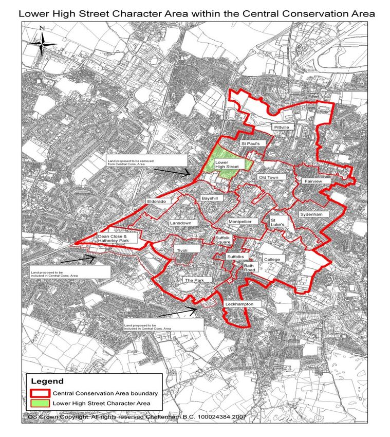
18. Lower High Street Character Appraisal & Management Plan – July 2008
Central
                        Conservation Area

   18. Lower High Street Character Area
     Appraisal and Management Plan
                                        July 2008

18. Lower High Street Character Appraisal & Management Plan – July 2008
Contents                                                                  Page

Part 1 – Character Appraisal                                              1

1. Introduction                                                           2
What is a Conservation Area?                                              2
The need for an appraisal                                                 2
Planning context                                                          2
The Central Conservation Area                                             3
Lower High Street Character Area                                          3
Summary of special interest                                               4
Lower High Street Character Area within the Central Conservation Area     5

2. Location and setting                                                 5
Location and context of Cheltenham                                      5
General character and plan form of the Lower High Street Character Area 6
Wider landscape setting                                                 7

3. Historic development                                                   7
Archaeology within the town of Cheltenham                                 7
Summary of Historic Development of Cheltenham                             8
General history of the Lower High Street character area                   8
Development by 1776                                                       9
Development by 1820                                                       9
Development by 1834                                                       10
Development by 1897                                                       11
Development by 1932                                                       11
Development by 2007                                                       12
Historical Development of the Lower High Street Character Area            13

4. Spatial Analysis                                                       14
The character and interrelationship of spaces within the                  14
area and key views/vistas

5. Character Analysis                                                     17
Use of area and how use creates special interest                          17
Architecture and historic qualities of buildings                          20
Index of Buildings of Local Importance                                    24
Contribution of key unlisted buildings                                    24
Positive buildings                                                        25
Some local details                                                        25
Materials                                                                 26
Contribution of trees and green spaces                                    27
Negative factors                                                          29
Neutral areas                                                             31
General condition of area                                                 31
Problems, pressures and capacity for change                               32

18. Lower High Street Character Appraisal & Management Plan – July 2008
Contents                                                                  Page

Part 2 – Management Plan                                                  33

1. Introduction                                                           34
2. Article 4 directions                                                   35
3. Cheltenham West End Partnership                                        35
4. Management proposals                                                   36

Annex 1 – Cheltenham Central Conservation Area                            43
Supplementary Planning Documents
List of figures                                                           44
Bibliography                                                              45

18. Lower High Street Character Appraisal & Management Plan – July 2008

Key characteristics

    This Character Appraisal of the Lower High Street Character Area within
    Cheltenham’s Central Conservation Area concludes that the special interest of
    the area derives from the following key characteristics:

    ¾ The Character Area has special historic value, dating from the Medieval
      period when the High Street was the only street in Cheltenham;
    ¾ The pattern and layout of streets varies throughout the area, with a
      predominance of compact artisan terraced housing mixed with modern
      terraced housing and semi-detached houses;
    ¾ Winston Churchill Memorial Gardens covers an extensive area, providing an
      open green space which is well used for recreation;
    ¾ A large number of retail businesses are located in the Character Area which
      contribute to its use and character today;
    ¾ The area contains large numbers of extensive Regency and Victorian
      terraced houses which form a distinct identity for the Lower High Street;
    ¾ A small number of buildings retain original features including ironwork which
      greatly enhances the historic character and special qualities of the area;
    ¾ This Character Area contains over 35 statutory listed buildings (some of
      which are grouped under the same listing) and some locally indexed buildings
      and structures, giving it a rich architectural and historic interest.

    Key issues

    A number of problems and issues have been identified and have a negative
    impact on the character of the Lower High Street character area. These form the
    basis for the Management Proposals of the Management Plan in the Part 2 of this
    document and are summarised below:

    ¾ Control of new development;
    ¾ Loss of traditional architectural features on some historic buildings;
    ¾ Negative impacts of the presence of equipment or installations on or around
      buildings, such as large aerials and satellite dishes;
    ¾ Poor street furniture;
    ¾ Tree management;
    ¾ Boundary enclosures;
    ¾ Enhancement of existing buildings and land;
    ¾ Setting and views;
    ¾ On-street parking;
    ¾ Car parks;
    ¾ Graffiti;
    ¾ Derelict buildings;
    ¾ Paraphernalia on road junctions.

18. Lower High Street Character Appraisal & Management Plan – July 2008
Part 1 – Character Appraisal
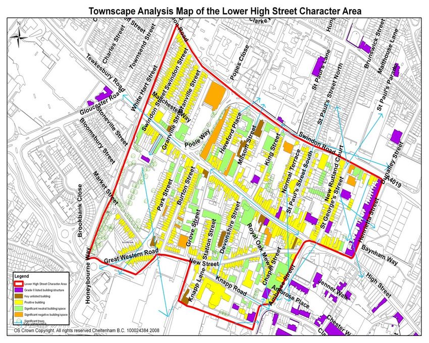
Figure 1 – Townscape Analysis Map of the Lower High Street Character Area
18. Lower High Street Character Appraisal & Management Plan – July 2008 1
1        INTRODUCTION

         What is a Conservation Area
1.1      A Conservation Area is an area of special architectural or historic interest, the
         character or appearance of which is considered to be worth preserving or
         enhancing. It is given special protection under the Planning (Listed Buildings
         and Conservation Areas) Act 1990 and Government policy in relation to
         Conservation Areas set out in Planning Policy Guidance 15 (PPG15). This
         legal protection enables the best features of an area to be preserved and new
         buildings and street works to be designed in-order that they enhance the
         area.

1.2      Some building work which does not require planning permission (known as
         “permitted development”) can damage the special qualities of a Conservation
         Area. “Article 4” directions can be applied by the planning authority to limit
         permitted development rights and thus give extra protection to particular
         buildings.

         The need for an appraisal
1.3      PPG15 stresses the need for local planning authorities to make an
         assessment of the special character and appearance of all Conservation
         Areas in their districts. The Government has also made the preparation of
         such assessment appraisals for all conservation areas a Best Value
         Performance indicator for local authorities. These assessments should be
         reviewed by local planning authorities every five years.

1.4      This document has been split into two parts. Part 1 of the document forms the
         character appraisal which provides an assessment of the character of a
         conservation area or parts of it. This appraisal provides the basis for Part 2,
         which comprises a management plan which gives guidance on how the
         preservation or enhancement of the character or appearance can be
         achieved. It also provides a sound basis for development control decisions
         made by local authorities (such as the design of highways or the
         appropriateness of the design of new buildings or open spaces).

1.5      Both parts will have a period of public consultation before the management
         plan is adopted as a Supplementary Planning Document, and used in
         conjunction with the Local Plan as a material consideration in determining
         planning applications.

         Planning context
1.6      Cheltenham Borough Council has various adopted and emerging planning
         related documents. They can be found on the Council's website -
         www.cheltenham.gov.uk. Some of the documents are quite broad in their
         content, whilst others are thematic, site specific or area specific. However, all
         fall within the statutory planning framework and all are material considerations
         in determining planning proposals. Together these documents look at various
         aspects of the built environment and need to be read as a whole within a
         particular context.

1.7      This document is part of that overall framework. The Character Appraisal
         (Part 1) is one of a number of such documents each assessing the character
         of parts of the conservation area and highlighting negative issues, which are

Lower High Street Character Appraisal & Management Plan – Draft for public consultation   2
then addressed through Management Proposals within the Management Plan
         (Part 2). In developing planning proposals, the Character Appraisal and
         Management Plan need to be considered along with advice, guidance and
         policy set out in other planning documents, be they general, thematic or
         spatially specific.

1.8      Cheltenham’s Civic Pride project aims to regenerate specific areas within the
         town. The project intends to develop and deliver public realm enhancement
         schemes and redevelop under-utilised council land including car-parks. More
         information on Civic Pride can be found at www.cheltenham.gov.uk This
         project falls within part of the Lower High Street Character Area. See
         Management Proposal 14 ‘Civic Pride’ in the Part 2 Management Plan for
         further detail.

         The Central Conservation Area
1.9      Cheltenham is known as the most complete Regency town in England. It lies
         at the foot of the Cotswold scarp, where the valley of the River Chelt meets
         the Severn Vale. Currently the whole of the Cheltenham Borough area has a
         population of approximately 112,000 people.

1.10     Cheltenham’s Central Conservation Area was designated by Gloucestershire
         County Council on 28th May 1973 and its boundary was extended by
         Cheltenham Borough Council on 14th August 1987. The Central Conservation
         Area includes the whole of the town centre, most of the Victorian, Edwardian
         and some of the later 20th century suburbs. It covers commercial, industrial,
         retail and residential areas, as well as the University campus complexes,
         some extensive school campuses and the hospital complex.

1.11     There is a Government requirement for existing Conservation Area
         boundaries to be re-assessed from time to time. Due to the size of the Central
         Conservation Area (reputedly the largest Conservation Area in Europe
         covering 600 hectares), it has been necessary to establish approximately 19
         character areas. These have been appraised separately in-order to identify
         their individual key components and in turn establish how each area may best
         be preserved and enhanced.

         Lower High Street Character Area
1.12     In May 2001 Cheltenham Borough Council published a draft Urban Design
         Framework for Cheltenham, produced by Latham Architects (the “Latham”
         Study). It was never formally adopted by the Council, but has been a useful
         stepping stone for the development of a number of subsequent initiatives. It
         included a plan which divided the whole town into character areas and is the
         basis of the character area boundary used in this study.

1.13     The selection of the 19 character area boundaries has no impact on the
         overall boundary of the Central Conservation Area. Although as part of the
         work for the preparation of the character area appraisals, consideration has
         been given to possible boundaries of the Central Conservation Area being
         revised in the future as a separate piece of work.

1.14     The boundaries of the Lower High Street Character Area within Cheltenham’s
         Central Conservation Area (see Fig. 2) have been influenced by the
         positioning of the character areas of St. Paul’s to the north and Old Town to
         the east. The western boundary of this character area derives from the

18. Lower High Street Character Appraisal & Management Plan – July 2008               3
western boundary of the Central Conservation Area, which follows the route
         of the old Great Western Railway Cheltenham and Honeybourne Line, which
         is now the Honeybourne cycle track. The southern boundary wraps around
         the terraced houses on the south side of Great Western Road, the buildings
         on Knapp Lane and buildings on the south side of Knapp Road. This line has
         been influenced by the decision to remove the area around the Waitrose
         development and Jessop Avenue from the Central Conservation Area. This
         area is proposed to be removed from the Central Conservation Area when a
         boundary review is able to take place.

1.15     Today, the Lower High Street comprises a mix of retail, light industry and
         residential land use. An important part of the area is occupied by Winston
         Churchill Memorial Gardens, which provides an attractive green public space
         in the busy urban area. There has been a significant amount of 20th-21st
         century development throughout the Character Area. In some situations, the
         modern developments are a negative contrast to, and detract, from the
         historic buildings in terms of architectural style, size, scale and materials. A
         number of the historic buildings retain original features, such as ironwork,
         which contribute to the historic character and special qualities of the area.

         Summary of special interest
1.16     The Lower High Street is special because:

    ¾ The Character Area has special historic value, dating from the Medieval
      period when the High Street was the only street in Cheltenham;
    ¾ The pattern and layout of streets varies throughout the area, with a
      predominance of compact artisan terraced housing mixed with modern
      terraced housing and semi-detached houses;
    ¾ Winston Churchill Memorial Gardens covers an extensive area, providing an
      open green space which is well used for recreation;
    ¾ A large number of retail businesses are located in the character area which
      contribute to its use and character today;
    ¾ The area contains large numbers of extensive Regency and Victorian
      terraced houses which form a distinct identity for the Lower High Street;
    ¾ A small number of buildings retain original features including ironwork which
      greatly enhances the historic character and special qualities of the area;
    ¾ This character area contains over 35 statutory listed buildings (some of which
      are grouped under the same listing) and some locally indexed buildings and
      structures, giving it a rich architectural and historic interest.

18. Lower High Street Character Appraisal & Management Plan – July 2008                 4
Figure 2 Lower High Street Character Area within the Central Conservation Area
2 LOCATION AND SETTING
Location and context of Cheltenham
2.1 Cheltenham is located in Gloucestershire. It is approximately 8 miles east of
Gloucester, 40 miles west of Oxford and is immediately to the east of the M5
motorway. The town is set on low-lying land at the foot of the Cotswold scarp.
Views of the Cotswold scarp from within the Conservation Area contribute to
its character and setting. The town is surrounded by open countryside. Much
of this is protected by the statutory Cheltenham/Gloucester Green Belt (to the
west and north) and the Cotswold Area of Outstanding Natural Beauty
18. Lower High Street Character Appraisal & Management Plan – July 2008 5(AONB) to the south and east. To the west of Cheltenham is the River
Severn, with the Forest of Dean and Wales beyond the Severn.
General character and plan form of the Lower High Street
character area
2.2 The Lower High Street Character Area is positioned immediately to the west
of Cheltenham’s town centre. Poole Way and Swindon Road are busy roads
(being part of the Northern Relief Road) and join the A4019 Tewkesbury
Road in the west. Swindon Road forms the northern boundary of the
Character Area, serving as a distinctive boundary between Lower High Street
and St. Paul’s Character Area. The High Street runs through the centre of the
Character Area, and is often congested by through traffic. The Lower High
Street forms a distinct space, being closed visually to the west by the railway
bridge which forms a strong visual barrier (where the Honeybourne Line
forms the western boundary of the Character Area and overall Conservation
Area) and closed visually to the east by a bend in the road at no. 269 High
Street.
2.3 The roads in the Lower High Street Character Area tend to be narrow historic
residential streets, which include Park Street and Devonshire Street. Jeremy
Jefferies states that “Park Street is unusual in…the conservation area…in having a
consistent frontage on one side of the street. Its east side was never fully developed”1
There are a small number of wider streets such as Swindon Road and the
High Street. Roads tend to be set out in an irregular grid pattern.
2.4 Narrow roads running either side of the High Street such as Burton Street and
Granville Street contain:
• Compact artisan terraced housing;
• A predominance of residential terraced
houses although there are some small
scale businesses such as car repair
garages present;
• Some modern infill development;
• Much on-street parking.
Figure 3 Granville Street
2.5 The wider roads such as the High Street contain:
• Predominantly commercial land use;
• Some derelict buildings;
• Spaces are busy with both vehicular
traffic and pedestrians;
• Much on-street parking;
• Jeremy Jefferies points out that “building
heights are inclined to increase towards the
town centre, particularly to the east of no.
Figure 4 High Street 330 High Street.”2
1
Jefferies, J. (1997) Cheltenham (Central) Conservation Area Character Appraisal District No 28 – Draft Report
October 1996, pg. 16
2
Jefferies, J. (1997) Cheltenham (Central) Conservation Area Character Appraisal District No 28 – Draft Report
October 1996, pg. 7
18. Lower High Street Character Appraisal & Management Plan – July 2008 6Wider landscape setting
2.6 The Lower High Street is surrounded on all sides by urban development. To
the north and east are positioned St Paul’s and Old Town Character Areas.
The ward of St. Peter’s is located to the west, which lies outside the Central
Conservation Area. The Waitrose development and offices around Jessop
Avenue are located to the south. Some views of the Cotswold escarpment
can be seen to the north and east over the lower roofs of buildings. Whilst
views of Leckhampton Hill can be seen from Winston Churchill Memorial
Gardens. These distant views create a rural connection between the
countryside and the urban area.
Some landmark buildings are present, which include Normandy House on the
High Street, St. Gregory’s School on Knapp Road, Murray House on St Paul’s
Street South and the Hindu Community Centre on Swindon Road. Landmark
buildings in other Character Areas are also visible, including St. Mary’s
Church and St. Gregory’s Church in Old Town Character Area and St. Paul’s
Church in St Paul’s Character Area.
Figure 5 View of Leckhampton Figure 6 The former Mission
Hill from Winston Churchill Hall (now the Hindu Community
Memorial Gardens Centre) on Swindon Road is a
landmark building
3 HISTORIC DEVELOPMENT
Archaeology within the town of Cheltenham
3.1 Some archaeological research has been conducted within the Borough of
Cheltenham and in-depth research can be found in “Pre-Regency
Cheltenham: An Archaeological Survey”.3 Many archaeological artefacts
would have been lost during the expansion of the town in the 19th century,
and so medieval and post-medieval finds have been very limited.
3.2 A few prehistoric remains have been found within the town, raising the
possibility that people from Neolithic, Bronze and Iron Age periods travelled or
lived here. An Iron Age enclosure ditch was uncovered on the site of the
present day Children’s Library in 1986-87. This indicates that an area of Iron
Age occupation was likely situated nearby.4 During the last 30 years,
archaeologists have pinpointed several areas within the town which have
been identified as likely areas of Roman occupation and where Roman
artefacts such as coins and pottery have been discovered.
3
‘Pre-Regency Cheltenham: An Archaeological Survey’ Cheltenham Art Gallery & Museum, 1975
4
‘Pre-Regency Cheltenham: An Archaeological Survey’ Cheltenham Art Gallery & Museum, 1975
18. Lower High Street Character Appraisal & Management Plan – July 2008 73.3 Within the Lower High Street Character Area, a number of finds have been
noted under the Gloucestershire Sites and Monuments Record. These
archaeological finds include evidence of a “timber framed building at 341 High
Street”5; a “Roman ditch and Saxon pottery found in Station Street”6; “post Medieval
ditches excavated on the site of St Gregory’s School”7 and “Roman coins found near
to the site of the former St James’ Station”8.
3.4 The “Chelt” element of Cheltenham’s name is amongst a number of the very
oldest names in the country – believed to be of pre-Celtic origin.
3.5 Archaeological remains unearthed provide a basis for researching the origins
and early development of Cheltenham, and contribute indirectly to a sense of
place evident in the modern era.
Summary of Historic Development of Cheltenham
3.6 The first documentary reference to Cheltenham itself occurs in an account of
the Council of Cloveshoe held in 803. It is highly likely, given the
archaeological finds and possible place-name derivation that Cheltenham
was in existence as a farming village for a long time before the 8th century. Its
status was raised to that of a market town in 1226 and the market played a
key role in its economy for several centuries. From c.1247 Cheltenham was
also a Liberty. Spa waters were discovered adjacent to the town in 1716 and
after King George III’s visit to sample the waters in 1788, Cheltenham grew
rapidly as a fashionable spa resort. The popularity of the town as a summer
resort resulted in Cheltenham having a wealth of tree-lined walks and rides,
squares and gardens. Its popularity led to expansion of the town away from
the ancient High Street, and many fine classical style buildings were built for
the growing population. The popularity of the spa waters waned from the
middle of the 19th century, and Cheltenham developed other roles in the form
of its growing importance as a major educational centre during the latter half
of the 19th century. In turn this led to the development well into the 20th
century of some acclaimed public schools and churches. Before World War II,
light industry boosted the town’s economy. The establishment of GCHQ in
Cheltenham immediately after World War II has had an enormous impact on
employment in the town. Today, the town’s attractions include fine shops and
events such as the races and numerous cultural festivals as well as its legacy
of Regency architecture, with trees, parks, gardens and public spaces.
General history of the Lower High Street character area
3.7 The historic development of the Lower High Street Character Area, based on
plans from 1776, 1820, 1834, 1897, 1932 and 2007 is shown on the Historical
Development map which accompanies this section (see Fig. 7). The
Character Area originates from the Medieval period when Cheltenham was a
market town. At this time the main street was the High Street and there were
lanes running at right angles from the High Street and then ending in open
fields. The High Street also runs through the Old Town Character Area and
the two Character Areas together encompass the heart of ancient
Cheltenham. Timber framed cottages were situated along the High Street
within burgage plots. With the development of Cheltenham as a fashionable
5
Gloucestershire Sites & Monuments Record – Summary Report for Area 21434 no page no. given
6
Gloucestershire Sites & Monuments Record – Summary Report for Area 22102 no page no. given
7
Gloucestershire Sites & Monuments Record – Summary Report for Area 21015 no page no. given
8
Gloucestershire Sites & Monuments Record – Summary Report for Area 9405 no page no. given
18. Lower High Street Character Appraisal & Management Plan – July 2008 8spa town, in the 19th century, extensive terraces sprung up along the High
Street, which frequently were comprised of shops on the ground floor and
living accommodation above. Terraced houses were also built in the narrow
roads running to the north and south of the High Street. These houses were
built for the artisan workers who served the wealthy who came to visit and live
within the town. In the early part of the 19th century, tram roads ran from the
quarries at Leckhampton, transporting building material across the town to
join the main line in the lower High Street by the coal wharf (where Tesco is
now located). From there they ran on to Gloucester Quay. Industry was
therefore very much prevalent in this area, and a number of slum houses
were built for workers who lived in poor conditions where disease was
common.
3.8 Jeremy Jefferies explains that “the street layout, the form of buildings, the lack of
ornament and of open space and the many interesting details of the historic fabric still
bear clear testament to the particular functions of this essential…part of the Regency
new town and of later development in Cheltenham (Central) Conservation Area.”9
3.9 In the 20th and 21st centuries the Character Area continues to have a mixed
residential and commercial character, with commercial premises being
predominantly located along the High Street. The majority of timber framed
buildings along the High Street have now been either substantially re-fronted
or demolished. The Character Area today has a bustling character which is
busy with shoppers and also as a residential area and vehicular route into
and from the town centre.
Development by 1776
3.10 G. Coales and Son produced a map of Cheltenham’s road layout on July 10th
1776. This map depicts few buildings and roads being present within the
Character Area at this time. By 1776 the length of the ancient High Street had
been laid out and a number of houses were present along the High Street and
New Street, which was marked on the 1776 map as The Knapp. By 1820,
The Knapp had become known as New Street. The only other road in the
Character Area was Fleece Lane, which was later named Henrietta Street.
Hodsdon explains that this street was, for a long time, “…the site of an animal
pound and cattle market.”10 Swindon Road had existed since at least “…1606
(and was known then as) Swyndones waye”11, but is not shown on the map. The
roads running roughly east to west (High Street, New Street and Swindon
Road) were developed unusually early compared with the development of
other predominantly residential streets, which were largely constructed in the
19th century and which connected with these early roads.
3.11 An important site within the area was the ‘Friends Burial Ground’ in Grove
Street. Land was acquired for a Quaker burial ground in the street shortly
after 1703.
Development by 1820
3.12 By the time the 1820 Postmaster map had been published, this ancient area
had become extensively developed. A number of roads had been laid out,
namely King Street, Milsom Street, Devonshire Street, Grove Street, Ambrose
Street, Market Street, Elmstone Street, Newman’s Place and Chapel Street.
9
Jefferies, J. (1997) Cheltenham (Central) Conservation Area Character Appraisal District No 28 – Draft Report
October 1996, pg. 10
10
J. Hodsdon ‘An Historical Gazetteer of Cheltenham’ (1997) pg. 81
11
J. Hodsdon ‘An Historical Gazetteer of Cheltenham’ (1997) pg. 175
18. Lower High Street Character Appraisal & Management Plan – July 2008 9Swindon Road is present on the map and is marked as Turnpike Road. A toll
bar was sited at the junction of the High Street with Gloucester Road, which is
positioned just outside the boundary of the Character Area and Central
Conservation Area.
3.13 The High Street was developed along its entire frontage by this time. It
contained compact terraced buildings which were positioned in long, narrow
burgage plots. Some of the ground floors of these buildings were occupied by
shops. The previously open land to the north and south of the High Street had
become enclosed following the Inclosure Act of 1801, which allowed the
development of this land.
3.14 An important building set back from the High Street was Segrave House, later
named Idminston House now known as Normandy House. The building was
constructed “c.1810-20…”12 and was originally built as a villa. However,
according to George Rowe, it “…was built as a dispensary in 1813…”13 and
became Cheltenham’s first General Hospital and Dispensary.
3.15 Chapel Street, Ambrose Street, Henrietta Street and King Street were
developed with artisan terraced housing along much of their length.
Approximately half of Milsom Street had been developed with detached and
semi-detached villas and terraced houses. Bethel Chapel was present at the
end of Chapel Street, occupying the space now taken up by the CPS building.
Ebenezer Chapel was positioned on King Street. It has been converted into
residential accommodation and is now known as King’s Court.
3.16 New Street led to Upper Alstone Mill and Alstone Spa. The site of Upper
Alstone Mill is now occupied by the petrol station on the Waitrose site. (The
area around Waitrose and Jessop’s Avenue is proposed to be removed from
the Central Conservation Area when the boundary is able to be reviewed in
the future. More detail can be found in the Bayshill Character Area Appraisal).
Upper Alstone Mill was a corn mill, being one of five Medieval mills within the
town. Alstone Spa was positioned to the north of Upper Alstone Mill. Hodsdon
states the spa was “active…from 1809 to 1834...”14 Hart states the spa
comprised “…an octagonal pump room and a small garden.”15
Development by 1834
3.17 Merrett’s map of 1834 conveys that further development had taken place
within the Character Area. Much of this development shapes the Character
Area today. Further roads had been laid out. These are St. Paul’s Street
South, Hereford Place, Burton Street and Park Street.
3.18 The space occupied by Winston Churchill Memorial Gardens was named St.
Mary’s new burial ground. Rowe explains how “The ground was purchased in
1830…”16 and became a burial ground due to the overcrowded nature of the
churchyard at St Mary’s. Park Street, Chapel Street, Ambrose Street, Burton
Street, Henrietta Street and King Street were almost fully developed with
artisan terraced housing. Grove Street and St. Paul’s Street South were partly
12
Department of Culture, Media & Sport ‘Revised List of Buildings of Special Architectural or Historic Interest –
Borough of Cheltenham’ (1998) pg. 415
13
Department of Culture, Media & Sport ‘Revised List of Buildings of Special Architectural or Historic Interest –
Borough of Cheltenham’ (1998) pg. 416
14
J. Hodsdon ‘An Historical Gazetteer of Cheltenham’ (1997) pg. 5
15
G. Hart ‘A History of Cheltenham’ (1965) pg. 148
16
G. Rowe ‘George Rowe’s Illustrated Cheltenham Guide 1845’ (1845, reprinted 1981) pg. 92
18. Lower High Street Character Appraisal & Management Plan – July 2008 10developed with terraced housing. Jeremy Jefferies explains that “Grove
Street…contained some of the town’s oldest and poorest housing.”17 A weighing
machine was positioned in St Paul’s Street South.
3.19 Approximately half of Milsom Street and Hereford Place had been developed
with artisan terraced housing. Knapp Lane was marked on the 1834 map as
Workhouse Lane. A large workhouse infirmary was located on Workhouse
Lane. Branch School on the High Street was situated next to the Royal Oak
Inn.
Development by 1897
3.20 The 1897 map shows most of the area being as built to the extent the
Character Area is today. Devonshire Street School for Boys had been built in
Devonshire Street in 1846-7 and St Paul’s Primary School was built in 1855-6
and positioned on Knapp Lane. A former ragged school18 was built in Milsom
Street in 1863-4 by well-known local architect John Middleton. It is interesting
to note the relatively high number of schools within the Character Area in the
19th century.
3.21 Swindon Street and Granville Street had become fully built with compact and
extensive artisan terraced housing.
3.22 Blake and Beacham state that “…in 1887 (the Alstone Municipal Baths
occupied)…the site of the old Alstone Mill.”19 These baths were marked as
‘Corporation Baths’ on the 1897 map. When the town’s new public pools
opened at Pittville, the Alstone Baths were little used and eventually closed
“…in 1975...”20
3.23 The General Hospital and Dispensary (currently known as Normandy House)
on the High Street was extended in 1839 in-order to add further wards. In
1849 the hospital closed due to the opening of Cheltenham General Hospital
in Sandford Road in 1848. Between 1853-6 the building was used as a
hospital for officers injured in the Crimean War. In the following years, the
wards were used as dormitories for female student teachers. The List
Description explains that this was “…prior to the erection of Shaftesbury Hall (in)
St Georges Place in c1869.”21
Development by 1932
3.24 For a period in the early part of the 20th century untilmid 1960s Normandy
House was the local Inland Revenue office and later became the offices for a
holiday company. It still has an office use
By 1932 the Character Area contained a small amount of further
development. Station Street had been laid out with terraced houses along its
west side. Great Western Road had become extended to meet with St.
George’s Road. A saw mill was located to the south of Alstone Swimming
Baths and a coal depot was located to its eastern side. A stone and timber
yard were also located on Knapp Road. These industries were linked with the
nearby St James Railway Station. The site of the timber yard on Knapp Road
was the future site of St Gregory’s School.
17
Jefferies, J. (1997) Cheltenham (Central) Conservation Area Character Appraisal District No 28 – Draft Report
October 1996, pg. 4
18
Ragged schools is a name given to the 19th century charity schools in the United Kingdom which provided
education and, in most cases, food, clothing, and lodging for destitute children. They received no government
support. - http://en.wikipedia.org/wiki/Ragged_school
19
S. Blake & R. Beacham ‘The Book of Cheltenham’ (1982) pg. 105
20
R. Brooks ‘The Story of Cheltenham’ (2003) pg. 196
21
Department of Culture, Media & Sport ‘Revised List of Buildings of Special Architectural or Historic Interest –
Borough of Cheltenham’ (1998) pg. 416
18. Lower High Street Character Appraisal & Management Plan – July 2008 113.25 The Great Western Railway brought a number of cottages on White Hart
Street (also known as White Hart Lane) which they “…demolished (in) 1903 in
preparation for the railway embankment.”22 This section of the embankment forms
part of the western boundary of the Character Area and Central Conservation
Area.
3.26 The area to the north of the High Street had been fully developed, the
predominant built form being terraced housing. The area to the south of the
High Street had also largely been developed with terraced housing.
Development by 2007
3.27 Bradbury states that “…the former St Mary’s Cemetery was razed for the Churchill
Memorial Gardens in 1965.”23
3.28 The Lower High Street Character Area has seen much change since 1932.
Slum clearances in the late 1930’s removed a number of buildings from the
terraced streets. Such streets included Grove Street and Hereford Place. The
terraced houses removed on Grove Street have been replaced by light
industry works and car repair garages.
3.29 St. Gregory’s Catholic School off Knapp Road was built in 1936 and replaced
a timber yard and several small buildings. The housing development of Royal
Oak Mews was developed in 1994 on the site of the Royal Oak/Irish Oak
public house’s rear yard. New Rutland Court was also developed in 1994 on
the site of the Head Quarters of the 1st Gloucestershire Royal Engineers, as is
marked on the 1902 map.
3.30 Planning permission was granted in 1984 for the construction of the Royal
Mail sorting office on Poole Way, on the site of a former depot. This sorting
office generates activity in this locality throughout the day.
3.31 Swindon Road forms part of the Northern Relief Road and carries high
volumes of traffic throughout the day. Significant levels of slum clearance also
took place in the narrow residential streets which run between the High Street
and Swindon Road. The north side of Swindon Road was also cleared in
parts. Consequently, the area around Swindon Road became blighted and
has only really begun to revive in recent years.
3.32 A number of historic buildings have been converted to different uses in the
latter part of the 20th century. For example, the former St Paul’s Primary
School on Knapp Lane was “…converted to offices (in) 1988 by Gordon Milne
Hogg (Architects).”24 The Devonshire Street School and Schoolhouse in
Devonshire Street was “…converted to housing in 1993.”25
3.33 A number of timber framed houses were demolished or re-faced along the
High Street. Some terraced houses were demolished to make way for car
repair garages on King Street, New Street and Milsom Street. A rare building
estimated to be at least 400 years old in 1963, was situated between
Henrietta Street and St George’s Street immediately left of the public High
Street car park. Historically it was number 168 High Street, which is now
number 285, following renumbering of the High Street. It was a timber framed
building positioned in a burgage plot. The building had a variety of historic
22
J. Hodsdon ‘An Historical Gazetteer of Cheltenham’ (1997) pg. 194
23
O.C. Bradbury ‘Cheltenham’s Lost Heritage’ (2004) pg. 82
24
Cheltenham Borough Council Index of Buildings of Local Importance, Item No. 310 (adopted by Full Council 28
June 2007) record no. 162 out of 422
25
Cheltenham Borough Council Index of Buildings of Local Importance, Item No. 309 (adopted by Full Council 28
June 2007) record no. 78 out of 422
18. Lower High Street Character Appraisal & Management Plan – July 2008 12uses, which included being used “…as a farmhouse, inn, ‘music warehouse’ and
bakery.”26 It became “…the first Government post office in Cheltenham (in 1805).”27
Its final use was as “…the ‘Old Rope Shop’ until 1967, when it was demolished.” 28
This Medieval building was replaced by the functional brick building housing
‘HFC Bank’.
3.34 Today, the Lower High Street character area retains its unique mix of
commercial and residential units, which are contained in a variety of buildings.
Evidence of its Medieval history remains apparent in the area, through the
continued existence of the burgage plots and narrow lanes running from the
High Street. These physical reminders strongly contribute to the character
area’s special qualities and character.
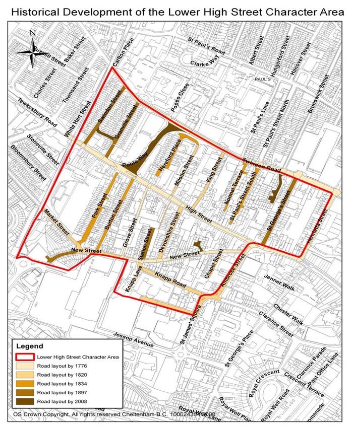
Figure 7 Historical Development of Lower High Street Character Area
26
O.C. Bradbury ‘Cheltenham’s Lost Heritage’ (2004) pg. 57
27
O.C. Bradbury ‘Cheltenham’s Lost Heritage’ (2004) pg. 57
28
O.C. Bradbury ‘Cheltenham’s Lost Heritage’ (2004) pg. 57
18. Lower High Street Character Appraisal & Management Plan – July 2008 134 SPATIAL ANALYSIS
The character and interrelationship of spaces within the area and
key views and vistas
Public and private space
4.1 Public and private spaces, together with
views out of, into and within the Lower
High Street Character Area impact
largely on the area’s character and
appearance. Many roads in the area
which run north and south of the High
Street have are narrow and experience
high levels of on-street parking. The
other roads, including the High Street
Figure 8 View of St Gregory’s and Swindon Road are wide which
Church spire from end of Market enables distance views of landmark
Street buildings such as the spires of St
Gregory’s Church and St Mary’s Church
and the tower of St Paul’s Church. The
width of Swindon Road and the space
within Winston Churchill Memorial
Gardens allows views of the distant
Cotswold escarpment;
4.2 The residential streets within the area
tend to be positioned both to the north
and south of the High Street. The
dominant built form is 19th century
artisan terraced housing. These terraced
houses often front directly onto the
footpath or have very small front
yards/gardens, which together with high
levels of on-street parking, creates a
Figure 9 Compact terraced sense of contained linear space within
houses on Swindon Street the street. In contrast, red-brick semi-
detached houses of St Paul’s Street
South are set back from the pavement
and have front gardens. This gives an
apparent sense of space which together
with the gaps between the houses
enables views to open up;
Figure 10 Red brick houses on
St Paul’s Street South
18. Lower High Street Character Appraisal & Management Plan – July 2008 144.3 The junction of Poole Way with the High Street is a visually prominent area in
need of some enhancement. The West End car park is a poor quality space.
This area in general is a negative feature within the character area;
4.4 The junction of the High Street with Ambrose Street is another poor quality
public space, which is in need of some enhancement. There is a high level of
street clutter on this junction which provides a poor setting for positive spaces
and buildings, such as the bowling green and Normandy House. In addition
some of the shop fronts are decorated in garish colours and designs;
4.5 Buildings along Knapp Road and in the north-west corner of St James’
Square have a mixed use and tend to be detached with are of a
comparatively large size and scale to that of the terraced and semi-detached
houses in the Character Area. These larger buildings, many of which are
modern developments, are sited within substantial plots which create a sense
of space;
4.6 Due to the dense urban grain of the immediate surrounding area, the
extensive public space of the Winston Churchill Memorial Gardens is
particularly valuable, Distance views of further the surrounding areas which
include an attractive vista of Christ Church (in the Lansdown Character Area)
can be seen from the Gardens. The gardens provide an important
recreational space, and they enhance the character and appearance of the
Lower High Street and contribute to its special historic qualities.
Boundary treatments
4.7 Some buildings are separated from public space by the use of various
boundary treatments. These are a visible and distinct division between public
and private space. Boundary treatments predominantly take the form of
enclosing red-brick walls. A high brick wall forms part of the former Great
Western Railway Cheltenham and Honeybourne Line. It acts as a distinct
boundary, which encloses the west side of the Winston Churchill Memorial
Gardens. Fencing acts as a poor, unattractive boundary. Some historic
railings remain such as those around Wesley House in St. George’s Street
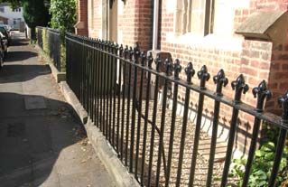
and the former schoolhouse in Devonshire Street. Historic railings are an
attractive, traditional form of boundary treatment which permit views through
them and enhance the appearance of streets;
Figure 11 High brick wall of railway Figure 12 Railings around former
embankment schoolhouse in Devonshire Street
4.8 Many of the historic terraced houses front directly onto the back edge of the
pavement and therefore front boundary treatment is un-necessary;
4.9 Gardens, historically and today, form an attractive traditional front area to
both historic and modern buildings, providing them with a colourful interesting
setting and enhancing the special qualities of properties and the street. Trees
18. Lower High Street Character Appraisal & Management Plan – July 2008 15and shrubbery in gardens help screen properties from public view, which
creates privacy. Front gardens can be found along St. Paul’s Street South.
Their presence is valuable in the overall appearance of the Character Area.
Key views and vistas (see Fig. 1)
4.10 There are views of landmark buildings both within and outside the Character
Area from a number of vantage points throughout the Character Area. Such
landmark buildings outside the area include the old gasworks on the corner of
Gloucester Road and Tewkesbury Road (now part of the Tesco site); St
Peter’s Church, St Paul’s Church and St Gregory’s Church. Prominent
landmark buildings in the character area include Normandy House, Wesley
House and St Gregory’s School;
4.11 The spires of St Mary’s Church and St
Gregory’s Church (in Old Town
Character Area) can be seen from the
open spaces and gaps between
buildings throughout the Lower High
Street Character Area. They are
attractive and striking features within
street scenes. St Gregory’s Church also
Figure 13 View of St provides a striking vista stop along
Mary’s Church spire from
St George’s Street Ambrose Street from the High Street;
4.12 St. Paul’s Street South forms an eye-
catching, attractive vista of St. Paul’s
Church (in St Paul’s Character Area).
Figure 14 Vista of St
Paul’s Church from St
Paul’s Street South
4.13 The pedestrian bridge, constructed as part of the Waitrose development in
the early part of the 21st century, connects sections of the Honeybourne Line
(former Great Western Cheltenham to Honeybourne Railway Line). Although
outside the boundary of the Character Area, the size and design of the bridge
enables it to be a striking feature from Great Western Road;
4.14 An interesting vista is experienced from
the end of Park Street, looking in a
south-westerly direction. The red-brick
terraced houses on Great Western Road
are striking features in the foreground.
The mass of St James Apartments near
to the Waitrose development can be
seen rising behind the terraces. The
Figure 15 View from Park
tower of Christ Church can then be
Street looking in a south- viewed behind the apartment block,
westerly direction
18. Lower High Street Character Appraisal & Management Plan – July 2008 16rising into the skyline. This particular
view offers an interesting visual contrast
between the different sizes, scales,
ages, materials and architectural styles
of these various buildings. In this specific
context this variety is positive.
4.15 Views of the Cotswold escarpment and
Leckhampton Hill can be appreciated
from Swindon Road and Winston
Churchill Memorial Gardens
respectively. These views enhance the
greenery within the generally hard urban
landscaping of street scenes in the
Character Area.
Figure 16 View down
Swindon Road of Cotswold
escarpment
5 CHARACTER ANALYSIS
Use of area and how it creates special interest
Residential
5.1 The Lower High Street Character Area has historically been a residential and
commercial area. The predominant historic built form is extensive artisan
terraced houses which form a unique identity for the area. These houses
have a compact plan form and are high in density;
5.2 Some infill development has taken place during the latter half of the 20th
century and into the 21st century. The impact of these housing developments
e.g. Royal Oak Mews varies within different areas;
5.3 Some large modern purpose built blocks have been erected within the area
such as numbers 19 and 20 Ambrose Street. This comprises a shop on the
ground floor with three storeys of flats above.
Figure 17 Terraces Figure 18 Royal Oak Figure 19 19 and 20
along St George’s Street Mews development Ambrose Street
18. Lower High Street Character Appraisal & Management Plan – July 2008 17Commercial / Business
5.4 A number of offices are located
throughout the area in both modern
purpose built blocks and in converted
Figure 20
Parker Court historic buildings. Normandy House, the
offices on former school in Milsom Street and the
Knapp Lane former St Paul’s primary school in Knapp
Lane have all been converted into
offices;
5.5 The entire length of the High Street in
the Character Area is taken up by
commercial properties. They have a
major impact on the character of the
area. They include estate agents, public
houses, restaurants, fast food units, car
sales garage, music shops and various
other specialist shops. These
Figure 21 Commercial commercial premises create a large
premises along the High amount of pedestrian movement along
Street the High Street, which generates noise,
activity and vitality in the area throughout
the day and evening;
5.6 There are six public houses in the character area, which help to create a busy
and lively atmosphere throughout the day and evening;
5.7 There are a number of car repair garages located throughout the area, which
provide a contrast to the dominance of retail units. These garages produce
traffic levels, noise and activity.
St. Gregory’s School
5.8 There is one school which remains in its
original use in the Character Area - St.
Gregory’s School. The presence of this
building generates high levels of traffic in
the mornings and afternoons, as well as
noise and activity throughout the day.
Together with the adjacent Catholic
Church of St Gregory’s, it also creates a
Figure 22 St Gregory’s sense of community within the
School immediate area as well as the wider
area of the town. It is an important focal
point.
18. Lower High Street Character Appraisal & Management Plan – July 2008 18Winston Churchill Memorial Gardens
5.9 This expanse of public park is a
particularly valuable green space within
its built-up surroundings. The gardens
contain a playground and landscaped
garden which provide a tranquil
sanctuary from the noisy surrounding
urban area.
Figure 23 Play area within
Winston Churchill Memorial
Gardens
Road use
5.10 Swindon Road forms part of the Cheltenham Northern Relief Road and
experiences heavy traffic throughout the day;
5.11 Poole Way is part of the Northern Relief
Road, which connects Swindon Road
with the High Street. Poole Way
experiences high levels of through traffic
throughout the day.
Figure 24 Traffic
congestion in Poole Way
5.12 Pedestrian movement is difficult across Poole Way, Swindon Road and the
High Street. These are busy roads and also have the clutter of traffic lights,
railings, barriers and other highway paraphernalia at junctions. As a
consequence there is a tendency for the two sides of these roads to become
severed;
5.13 The High Street also experiences a large volume of traffic throughout the day.
This traffic frequently comprises through traffic travelling into and out of the
town centre. Large delivery lorries often block parts of the High Street when
making a delivery;
5.14 The other roads in the Character Area tend to be mainly used by the
residents of the properties. Consequently there is much on-street parking
outside the historic terraces. Some roads such as Park Street have garages
along them. Relatively recent traffic management schemes have reduced the
use some of these residential roads as “rat-runs”.
Other uses
5.15 In addition there is an assortment of other uses including:
a) Community resources in the form of Cheltenham Community
Projects on Grove Street and Cheltenham 1st Stop on High Street.
These services are important in creating a sense of community
within the area and developing community projects to enhance the
area for its inhabitants;
18. Lower High Street Character Appraisal & Management Plan – July 2008 19b) Royal Mail sorting office on Poole Way, which occupies a large
space and is responsible for increased traffic flow along the road;
c) A weekly market in the High Street car park between St George’s
Street and Henrietta Street. This provides an important community
resource.
5.16 These all bring varying levels of activity throughout the day which greatly add
to the character and vitality of this area.
Architecture and historic qualities of buildings
5.17 The dominant built form in the Lower High Street character area is the
extensive artisan terraced housing. Most of this housing was established in
the early-mid 19th century and was developed on either side of the High
Street. A small amount of development took place in the 20th century through
slum clearance programmes and the establishment of modern residential
developments.
Historic terraces
5.18 The historic terraces were built
throughout the Character Area. They
tend to comprise of modest two-storey
terraces, although some three and four
storey terraces are also present. The
terraces along the High Street vary in
height which creates an alternating
roofline and a diverse and interesting
Figure 25 Terraced street scene.
buildings with varying
heights along the High
Street
5.19 The majority are faced in render, although some are faced in red-brick. A
small number of the terraces have parapet roofs; however houses frequently
have one high, central ridge which results in chimneys being a prominent
feature in streets. Some of the terraced houses have similar features and
detailing, which includes sliding sash windows, continuous cornice and red
brick chimney stacks. They do not have basements and have simple
architectural detailing. These unifying characteristics create strong uniformity,
along with the cohesion in rhythm, materials and mass within the street scene
which contributes to a strong identity for the area.
Figure 26 Rendered terraced Figure 27 Red brick terraced
houses on Market Street houses on Nailsworth Terrace
5.20 Some terraces front directly onto the street whilst others are set back from the
footpath and have small front gardens.
18. Lower High Street Character Appraisal & Management Plan – July 2008 205.21 The terraced houses on Milsom Street and Normal Terrace have a modest,
vernacular style to them, which adds to their character and charm.
5.22 Several historic shop fronts remain in
existence along the High Street. They
have largely retained their historic
architectural detailing and contribute to
establishing the historic character along
this ancient street. Their specialist uses
(including a DIY store, music shop,
sewing shop and radio and telephone
shop) help to establish the unique
Figure 28 Detailing on historic character and special qualities of the
shop front on Lower High Street Lower High Street.
5.23 All 32 terraced houses on the west side
of Henrietta Street are Grade II listed.
They were constructed as houses
although the ground floors of many
today have been converted into shops.
The buildings provide an impressive
element in the area’s townscape. The
terraces are predominantly 2 storeys
high although to the left they are 3
storeys with a mansard roof. The terrace
dates from “c1810-20…”29 and is
constructed from stucco over brick with a
Figure 29 Listed terraced
houses on Henrietta Street slate roof and brick chimney stacks.
Unifying features among the terraces
include sliding sash windows, fanlights
above doors, low parapet with copings
and first floor balconies (the majority of
which balconies have now been
removed). The 19th century “…shop fronts
include…Nos 16, 18 and 19…each have 2-
light windows with turned mullion and
entablature...”30
Other prominent historic buildings
5.24 Other prominent historic buildings within
the character area include St Mary’s
Cemetery Chapel, King’s Court, the
Christadelphian Hall, the former
Chemistry nightclub on St James’s
Square, 304 High Street and Normandy
House. The size, scale, footprint,
architectural design and material of
these buildings enhances the street
Figure 30 St Mary’s Mission scene in their individual localities. They
Hall, Winston Churchill Memorial also enhance the overall character and
Gardens
29
Department of Culture, Media & Sport ‘Revised List of Buildings of Special Architectural or Historic Interest –
Borough of Cheltenham’ (1998) pg. 377
30
Department of Culture, Media & Sport ‘Revised List of Buildings of Special Architectural or Historic Interest –
Borough of Cheltenham’ (1998) pg. 377
18. Lower High Street Character Appraisal & Management Plan – July 2008 21appearance of the area and contribute to
its special qualities.
20th and 21st Century development
5.25 Modern infill development is apparent throughout the area. New
developments sit with varying degrees of success in the historical context of
their area. The most notable housing developments are New Rutland Court
off Swindon Road and Royal Oak Mews off New Street. Both developments
date from the mid 1990’s. Hereford Court on Hereford Place is another
significant housing development which dates from the 1980s.
5.26 New Rutland Court was developed on
the former site of the Engineer
Volunteers Practice Ground. It consists
of red brick houses set within a
contained cul-de-sac. High numbers of
parked cars dominate the development.
The houses have a functional design
and do not sit well within their historic
surroundings.
Figure 31 New Rutland Court
5.27 Royal Oak Mews comprises semi-
detached houses and a terrace within a
contained cul-de-sac. This site was
formerly the rear yard of The Irish Oak
public house (332 High Street). This
development sits well within the historic
context of the area in terms of its size,
scale, setting, construction materials and
architectural detailing.
Figure 32 Royal Oak Mews
development
5.28 There are two substantial office blocks
located on Ambrose Street. One of the
two, the CPS (Creative Publishing
Solutions) block, has a high level of
glazing on its front elevation. Its roofline
rises higher than the terraced houses
positioned on either side, and it is of an
inappropriate scale in relation to its
surroundings. Consequently is a visually
Figure 33 CPS building on dominant building within the street scene
Ambrose Street
which does not enhance the historic
character or appearance of the area.
18. Lower High Street Character Appraisal & Management Plan – July 2008 22You can also read