Map Metadata: the Basis of the Retrieval System of Digital Collections - MDPI
←
→
Page content transcription
If your browser does not render page correctly, please read the page content below
International Journal of
           Geo-Information

Article
Map Metadata: the Basis of the Retrieval System of
Digital Collections
Marta Kuźma 1, *         and Hans Bauer 2
 1    Faculty of Civil Engineering and Geodesy, Military University of Technology, 00908 Warsaw, Poland
 2    Leibniz Institute for East and Southeast European Studies, Library and Electronic Research Infrastructure
      Division, 93047 Regensburg, Germany; hbauer@ios-regensburg.de
 *    Correspondence: marta.kuzma@wat.edu.pl

 Received: 13 May 2020; Accepted: 15 July 2020; Published: 17 July 2020

 Abstract: The article presents research on the evaluation of hidden map metadata. A hidden map is a
 map being part of a book that illustrates certain facts described in the book (e.g., military campaigns,
 political processes, migrations). The evaluation regards their completeness. Metadata completeness
 is the degree to which objects are described using all metadata elements. The analysis took into
 account the metadata of archival maps accessed via the GeoPortOst geoportal. Over 3000 hidden
 maps from the period 1572–2018 were analyzed, and the map set was divided into 8 collections.
 The main purpose of cartographers and librarians is to facilitate understanding of the relationship
 between individual information (librarians) and spatial data (cartographers). To this end, the research
 focused on the kind of information about old maps that should be stored in metadata to describe them
 in terms of space, time, content and context so as to increase their interoperability. The following
 metadata were taken into account in the assessment: title of content, type of content, date, date range,
 rights, language, subject, distribution format, geographic location, scale of map, reference system,
 mapping methods, map format, and source materials used to develop the map. The completeness of
 individual metadata as well as the completeness of metadata for individual collections was assessed.
 Finally, good practices of individual collections and metadata that could increase the interoperability
 of the entire collection were identified. The evaluation enables the owners to show the strengths and
 weaknesses of a given collection in a quick and easy way.

 Keywords: map metadata; archival documents; metadata evaluation; completeness

1. Introduction
      Cartographers and librarians have a lot in common. Their products share the same goal of providing
orientation regarding (spatial or informational) relations that are difficult to survey. They both have in
mind the needs of their users, who are looking for access to spatial entities or information. They both
use a set of instruments that highlight patterns and reduce complexity. The librarians’ traditional
product, the catalogue, may be described in the same words as [1] stated for maps: ‘Nothing [...] is
reality; everything is representation.’
      However, the mechanisms that cartographers and librarians have developed to represent realities
are different. Cartography encompasses the concept of ’space’ in graphic and mathematical terms, while
in libraries, information is made verbally accessible through documentation languages. Geographic
names are the main focus of attention here. This may be a problem when describing maps in libraries:
space is a physical constant, but geographic names can change in time [2,3].
      The progressing digitization of maps in libraries and the use of specific geodata portals allow this
problem in representing geographic media to be largely solved. Geographical media can be searched
for in more intuitive and effective ways (Figure 1), for example by using an interactive web map service.

ISPRS Int. J. Geo-Inf. 2020, 9, 444; doi:10.3390/ijgi9070444                           www.mdpi.com/journal/ijgi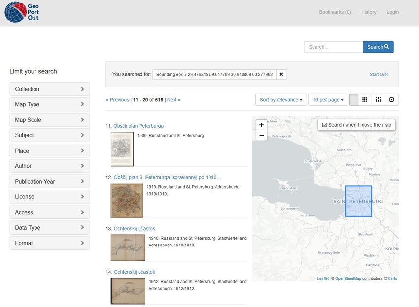
ISPRS Int. J. Geo-Inf. 2020, 9, x FOR PEER REVIEW 2 of 14
ISPRS The
Int. J.progressing
Geo-Inf. 2020, 9,digitization
444 of maps in libraries and the use of specific geodata portals allow
2 of 13
this problem in representing geographic media to be largely solved. Geographical media can be
searched for in more intuitive and effective ways (Figure 1), for example by using an interactive web
Networked spatial information not only allows for location-based resource searches, but also makes
map service. Networked spatial information not only allows for location-based resource searches, but
the exploration of topographic relationships possible [4].
also makes the exploration of topographic relationships possible [4].
Figure 1.
Figure 1. Geographic
Geographic search
search in
in GeoPortOst.
GeoPortOst.
implementation of a geographic interface makes it much easier to find maps of a specific
The implementation specific
area [5].
area [5]. However, it it is
is not
not sufficient
sufficient forfor aa comprehensive
comprehensive retrieval.
retrieval. Old maps maps andand thematic
thematic mapsmaps in in
particular come
particular come withwith aa specific
specific context
context of of provenance
provenance and and have
have aa specific
specific content.
content. There are many many
projects that
projects that analyze
analyze the the standardized
standardized description
description of of maps
maps in in digital
digital libraries,
libraries, which
which suggest
suggest waysways
which one can
by which can describe
describe old maps using library standards [6–8] or spatial data standards [9,10].
Additionally,certain
Additionally, certainprojects
projects whichwhich combine
combine archival
archival documents
documents from various
from various digital digital
librarieslibraries
[11,12]
[11,12]
and someand somecollect
others othersarchival
collect archival
cartographiccartographic
documents documents [13–15]. Subirana
[13–15]. Subirana [10] emphasized
[10] emphasized that it is
that itdescribing
worth is worth describing
old maps ofold maps of spatial
geographic, geographic,
data by spatial dataSDI
creating by(spatial
creating SDIinfrastructure).
data (spatial data
infrastructure).
SDI is known as an SDI is knownsetas
appropriate an appropriate
of institutional set and
policies of agreements,
institutionalstandards,
policies and agreements,
and technologies,
standards,
as and technologies,
well as human resources that as wellareasnecessary
human resources
for usersthat are necessary
to use geospatialfor users to usefor
information geospatial
various
information
purposes, notfor
justvarious
those for purposes,
which they notwere
just created
those for [16].which
Userstheyneedwere createdbetter
increasingly [16]. spatial
Users needdata
increasingly
that can be used better spatial data
according that needs
to their can be[17].
usedUnfortunately,
according to their needs
in huge [17]. Unfortunately,
collections, in huge
finding a specific
collections,
map finding
of interest a specific
is often map of interest
very difficult. We may is often
eithervery
find difficult. We may
a lot of results or either find at
no results a lot
all.ofDespite
results
or no results
many at all.
initiatives aimedDespite many initiatives
at improving aimed at improving
the interoperability the interoperability
of collections, quality should of collections,
be kept in
qualityasshould
mind, now itbe kept
will in mind,
require more asattention.
now it will It require more attention.
is also worth It is alsotoworth
paying attention whether paying attention
the proposed
to whetherare
standards the proposed
used to develop standards are used to
map collections in develop map collections
digital libraries and if thein digital libraries
metadata and if
are collected inthe
an
metadata areway,
appropriate collected
according in antoappropriate
the rules [18].way, according
Existing to thegaps
research rules[19]
[18]. Existing
were research
identified, gaps that
proving [19]
were is
there identified, proving
a strong need for newthat research
there is acontributions
strong need in forthe
new researchof
evaluation contributions
map metadata. in the evaluation
Therefore, the
of map
first metadata.
research Therefore,
question is: what thekind
firstofresearch
informationquestion
about is: old
what kindshould
maps of information
be storedabout old maps
in metadata to
should bethem
describe stored in metadata
in terms to describe
of space, them and
time, content in terms of space,
context time, their
to increase content and context to increase
interoperability?
theirThisinteroperability?
question is explored using the portal GeoPortOst: Thematic and Hidden Maps of Eastern
and Southeastern Europe [20] as an example. As it integrates cartographic resources of different
provenance, GeoPortOst is a good example of a new type of collection. Traditional library collectionsISPRS Int. J. Geo-Inf. 2020, 9, x FOR PEER REVIEW 3 of 14
This question is explored using the portal GeoPortOst: Thematic and Hidden Maps of Eastern
and Southeastern Europe [20] as an example. As it integrates cartographic resources of different
provenance, GeoPortOst
ISPRS Int. J. Geo-Inf. is a good example of a new type of collection. Traditional library collections
2020, 9, 444 3 of 13
are 'owned' and local [21]. In the digital world, this limitation no longer exists. The 'owned' resources
can interact with external ones in a network logic. As a result, in place of the physical stock, patterns,
are ’owned’ and local [21]. In the digital world, this limitation no longer exists. The ’owned’ resources
themes, or a research agenda become relevant for the construction of a collection [22]. GeoPortOst
can interact with external ones in a network logic. As a result, in place of the physical stock, patterns,
provides an infrastructure for aggregating heterogeneous documents in different formats and at
themes, or a research agenda become relevant for the construction of a collection [22]. GeoPortOst
various levels of indexing. The decisive factor for the portal is no longer keeping and preservation,
provides an infrastructure for aggregating heterogeneous documents in different formats and at various
but rather processing, arranging and sharing [23]. The digital collection thus loses its static nature
levels of indexing. The decisive factor for the portal is no longer keeping and preservation, but rather
and can be understood as a process of assemblage around the users’ needs [24]. What is crucial now
processing, arranging and sharing [23]. The digital collection thus loses its static nature and can be
is how entities are described in the metadata. We assume that ‘[...] metadata will govern the outcome
understood as a process of assemblage around the users’ needs [24]. What is crucial now is how
of the generation of transactional sets’ [25]. Therefore, the second research question is: which
entities are described in the metadata. We assume that ‘[...] metadata will govern the outcome of the
collection in GeoPortOst Project provides resources metadata in such a way as to give the users the
generation of transactional sets’ [25]. Therefore, the second research question is: which collection in
best chance of using the cartographic materials necessary for their research and for generating
GeoPortOst Project provides resources metadata in such a way as to give the users the best chance of
datasets?
using the cartographic materials necessary for their research and for generating datasets?
2.
2. Materials
MaterialsandandMethods
Methods
The
The subject of research
subject of research are
are metadata
metadata of of archival
archival cartographic
cartographic documents.
documents. Currently,
Currently, metadata
metadata
are the basis for searching objects in retrieval systems to find digital data. Based
are the basis for searching objects in retrieval systems to find digital data. Based on the metadata on the metadata
assessment,
assessment, wewe cancandetermine
determine the theextent
extentto towhich
whicharchival
archivalmaterials
materials are
are available
available to
to users
usersand
andassess
assess
the quality of map metadata. Quality is in this case understood as a set of features
the quality of map metadata. Quality is in this case understood as a set of features that determine how that determine
how the product
the product fits tofits to satisfy
satisfy certain
certain needsneeds
[26]. [26].
Based
Based on the evaluation of map metadatapresented
on the evaluation of map metadata presentedininthe
theresearch
researchof ofKuźma
KuźmaandandMościcka
Mościcka[27],
[27],
we conducted an analysis of hidden maps. A hidden map is a map being part of
we conducted an analysis of hidden maps. A hidden map is a map being part of a book that illustratesa book that illustrates
certain
certainfacts
factsdescribed
describedininthe book
the book(e.g., military
(e.g., campaigns,
military campaigns,political processes,
political migrations)
processes, [9]. The
migrations) [9].
methodology includes adopting a scope pattern, assigning metadata elements
The methodology includes adopting a scope pattern, assigning metadata elements from a particular from a particular map
collection to it, verifying
map collection how the
to it, verifying how metadata of a specific
the metadata digitaldigital
of a specific collection are consistent
collection with the
are consistent scope
with the
pattern, and the statistics on the evaluation of map metadata (Figure
scope pattern, and the statistics on the evaluation of map metadata (Figure 2.). 2.).
Workflowof
Figure2.2.Workflow
Figure ofmetadata
metadata evaluation.
evaluation.
The scope
The scope pattern
pattern defines
defineshowhowthethemetadata
metadataofof archival maps
archival mapsshould
shouldbe described. ThisThis
be described. pattern [27]
pattern
has has
[27] beenbeen
modified to reflect
modified the specifics
to reflect of hidden
the specifics maps.
of hidden The The
maps. whole scope
whole pattern
scope waswas
pattern divided into
divided
into two parts: the first one is connected with common metadata in a digital library and the secondis
two parts: the first one is connected with common metadata in a digital library and the second one
related
one to cartographic
is related metadata.
to cartographic metadata.
Compliance with the
Compliance with the scope scopepattern
patternisisassessed
assessedbased
basedononthe
thefeatures
features(how(howto to obtain
obtain data
data from
from
the metadata profile of a given digital library to the scope pattern, i.e., directly, by simple
the metadata profile of a given digital library to the scope pattern, i.e., directly, by simple analysis, or analysis,
or specialist
specialist analysis).
analysis). Individual
Individual features
features have
have been
been assignedweights
assigned weightsthat
thatallow
allowdetermining
determiningto towhat
what
extent (how easily/difficultly) data can be obtained. The level of difficulty of obtaining
extent (how easily/difficultly) data can be obtained. The level of difficulty of obtaining metadata may metadata may
be calculated by using the formula
be calculated by using the formula [27]: [27]:
n
X wk
E= (1)
n
k =1ISPRS Int. J. Geo-Inf. 2020, 9, 444 4 of 13
where:
n—the total number of criteria in scope pattern;
k—the criterion number;
wk —the weight of obtaining data (1.0—directly, 0.8—simple analysis, 0.5—specialist analysis,
0.0—lack of data) for k-th criterion.
The higher the value of E, the easier it is to obtain data.
The evaluation relates to the completeness. Metadata completeness is the degree to which objects
are described using all metadata elements [28].
2.1. Metadata Scope Pattern
The archival maps were analyzed in the study, on the one hand, as part of an information container,
such as books or magazines, and on the other hand, an independent representation of a geographical
space. With the above in mind, the metadata scope pattern was developed based on Dublin Core [29,30],
MARC21 (machine-readable cataloging) [31]. Some of the features, such as the title of the content, type
of content, date, date range, rights, language, subject, and distribution format, are directly connected
with digital objects in each digital library. They are very common, and all objects have this kind of
metadata. They are usually easy to gather and collect in databases.
Library staff should, however, possess knowledge about specific characteristics of maps.
This knowledge may be used for describing maps by using the geographic location, the scale of
the map, the reference system, mapping methods the, map format, and the source materials that were
used to develop the map. Those kinds of information do not have standardized metadata in Dublin
Core or MARC21 to collect specific cartographic features. Even though there are some initiatives which
demonstrate how MARC21 [6] or Dublin Core [7] can be used, each librarian may gather the same
information in a different way, without any rules, or each library may establish their own rules to collect
data. This means that the collections in different libraries are not interoperable. Therefore, the metadata
scope pattern was developed based on the research of Kuźma and Mościcka [27]. We have adopted
the following: type of content, date, date range, rights, language, subject, distribution format, such as
typical metadata, and geographic location, scale of map, reference system, mapping methods, map
format, and the source materials used to develop the map, such as cartographic metadata. The access
rights 1 and access rights 2 were included in rights. We added the title of content because often only
the title contained detailed information about a given map (such as the area or map topic) (Table 1).
Table 1. Metadata scope pattern (modified scope pattern from [27]).
Item (k) Evaluation Criterion Type of Metadata
1. Title of content typical
2. Type of content typical
3. Date typical
4. Date range typical
5. Rights typical
6. Language typical
7. Subject typical
8. Distribution format typical
9. Geographic location cartographic
10. Scale of map cartographic
11. Reference system cartographic
12. Mapping methods cartographic
13. Map format cartographic
14. Source materials used to develop the map cartographic
Two characteristics were used to evaluate the metadata:ISPRS Int. J. Geo-Inf. 2020, 9, 444 5 of 13
• Completeness for each of the evaluation criteria—Ek [27]:
8
X m ck
Ek = (2)
mc
c=1
where c—collection number from Table 2; mc —number of all maps in a particular collection;
mck —number of maps that have metadata for each evaluation criteria in a particular collection.
• Completeness for each collection depending on the number of resources in the digital collection
for typical metadata:
8
X mck
Etc = (3)
mc
k =1
depending on the number of resources in the digital collection for cartographic metadata
14
X m ck
Emc = (4)
mc
k =9
Table 2. Collections in the GeoPortOst Project.
Item (c) Collection Publication Date Number of Maps (mc)
1. Digital collections 1575–1918 170
2. Ethnodoc 2004–2018 231
3. GEI digital 1833–1918 632
4. GeoPortOst 1572–1934 1169
5. IEG-Maps 2000–2015 526
6. Lambda 2018 1
Handbook of the History of
7. 2016 36
Southeastern Europe
8. OstDok 1844–2017 262
Total= 3027
The biggest and the oldest collection is GeoPortOst, which gathers 1.169 historic maps, and the oldest map comes
from 1572. The newest resources come from Digital collections and Lambda.
The calculation connected with the evaluation of map metadata for collections in a particular
digital library is presented in the Results subsection.
2.2. Data
Our research was based on maps in the GeoPortOst Project [20]. GeoPortOst was developed at the
Leibniz Institute for East and Southeast European Research in Regensburg (IOS) from 2014 to 2019 with
funding from the German Research Foundation [32]. GeoPortOst provides access to maps of Eastern
and Southeastern Europe. The collection includes notably hidden, thematic maps related to history and
ethnography as well as the economic and social relations of this area. We define hidden maps as maps
that have been printed in publications and have been catalogued in a special catalogue at the IOS. The
special source value of hidden maps, especially for area studies on Eastern and Southeastern Europe,
lies in the fact that they stand directly in the context of scientific studies or political texts, and often
function as arguments in a narrative. Thus, they are not only orientation aids, but also the means
of scientific proof for spatial constructions. Maps of this kind reproduce ‘selective representations
of reality’ [33], visually highlighting qualitative dimensions of space or omitting them. The portal
currently contains 3027 digitized maps from several institutions. The maps were georeferenced in a
crowdsourcing campaign (using the Klokan Technologies Georeferencer application) and ingested in a
GeoBlacklight database [34].
The following collections are accessible in the project GeoPortOst:ISPRS Int. J. Geo-Inf. 2020, 9, 444 6 of 13
• Digital collections contains historic maps of Eastern Europe from 1575–1918.
• Ethnodoc contains statistical thematic maps from 2004–2018.
• Georg Eckert Institute (GEI) digital contains maps which come from the Georg Eckert Institute for
International Textbook Research.
• GeoPortOst contains maps from 1572–1934 of Eastern Europe.
• IEG-Maps contains maps that originate from the digital historical map server at the Leibniz Institute
for European History (IEG, German: Leibniz-Institut für Europäische Geschichte) —Mainz.
• Lambda is a portal that collects, processes, and provides data on work (economic and social),
migration and biographical data for Eastern and Southeastern Europe. LaMBDa supports historical
and economic research.
• The Handbook of the History of Southeastern Europe combines expert knowledge on over 2000
years of history and research. The project aims to make the complex historical time layers of
Southeastern Europe more understandable thanks to its unique reference work.
• Online Documents on Eastern Europe (The OstDok, German: Osteuropa-Dokumente online)
contains academic texts and documents on the history, politics and culture of Central, Eastern, and
Southeastern Europe. The portal is addressed to both scientists and a wider audience interested
in Eastern Europe.
The main details about each collection in GeoPortOst are presented in Table 2.
3. Results
Based on the presented methodology, GeoPortOst metadata were evaluated. Metadata in
GeoPortOst were entered according to the rules established by a team of librarians, historians, and
geographers at the Leibniz Institute for East and Southeast European Research. The rules were
created based on our experience and some of the recommendations concerning the use of MARC21 [6]
and Dublin Core [7], as well as the experiences of different initiatives for sharing digital maps on
the Internet [35,36]. The metadata for the maps were first exported from the library’s structuring
language Aleph sequential format (ASEQ) into a simple Excel spreadsheet, and then supplemented
with additional information that is not commonly found in library catalogues (e.g., after georeferencing
by coordinates or references to context documents). Each document is described by 60 attributes in 60
columns. In addition, all subjects of the maps from the authority files of the German National Library
(GND) [37] were refined with Wikidata [38] using Open Refine [39]. Finally, the table fields were
mapped to Dublin Core, Bibo and Geosparql and fed into a Solr index for final implementation with
GeoBlacklight [34]. Furthermore, the data are available in Resource Description Framework (RDF) and
can be queried via a Protocol and RDF Query Language (SPARQL) endpoint [40].
An inseparable part of the database is a spreadsheet in which administrative metadata (metadata
about metadata) and relationships between individual standards (Dublin Core [29], MARC21 [31],
ISO [41], Europeana Data Model [11]) are collected. It also contains metadata transformations so that
they can be used in systems based on these standards.
The most time-consuming part of the evaluation was to match information from metadata in the
analyzed digital library to the scope pattern. The assignment of metadata elements of the analyzed
collections to the adopted evaluation criteria is presented in Table 3, and the level of difficulty of
obtaining metadata was calculated according to Formula (1).ISPRS Int. J. Geo-Inf. 2020, 9, 444 7 of 13
Table 3. Assignment of metadata elements of the analyzed collections to the adopted evaluation criteria.
Item (k) Evaluation Criterion Metadata in GeoPortOst Weight (wk )
1. Title of content Title of the map 1.0
2. Type of content Type of map 1.0
3. Date Date of publication 1.0
4. Date range Temporal coverage 1.0
5. Rights Information on license 1.0
6. Language Language 1.0
7. Subject Topical subject heading 1.0
8. Distribution format Persistent uniform resource locator (PURL) of the map image 1.0
9. Geographic location North, south, east, west geographic coordinates 1.0
10. Scale of map The scale 1.0
11. Reference system Lack of information 0.0
12. Mapping methods Type of map 0.8
13. Width 1.0
Map format
Height
Author of the source
GND of the author of the source
Title of the source
Source materials used to
14. Year of publication of the source 1.0
develop the map
uniform resource locator (URL) of the source within the catalogue
Signature of the source within the catalogue
Reference of the map in the source
The level of difficulty obtaining metadata E= 12.8
Table 3 demonstrates clearly that the metadata contain elements that correspond to 13 out of 14
evaluation criteria. Almost each item of metadata was gathered directly from particular metadata in the
GeoPortOst database. This means that each evaluation criterion has an equivalent in the GeoPortOst
database, and the weights are equal to 1.0 for almost all criteria. Mapping methods were obtained
by using simple analysis, and their weight is 0.8. Unfortunately, the information about the reference
system is not provided in the GeoPortOst database (so its weight equals 0.0).
What is noteworthy is the separation of width and height when determining the map format,
so there is no problem using these numerical values to determine the details of the map (if we know
the extent of the geographical coordinates of the map).
According to the specific hidden maps, a very detailed description of the source documents is
provided. As a result, it is possible to determine the map’s reliability, time of creation, descriptive
information, and the type of data that were the basis for creating the map.
Having the above in mind, the level of difficulty equals 12.8 out of 14.0, which means that it is
very easy to obtain important metadata to the scope pattern.
Typical features, such as the title, the type, the date, the data range, rights, language, the subject, and
the distribution format were considered for evaluation. At first, the completeness for each evaluation
criterion (Ek ) was calculated according to Formula (2). Then, completeness for each collection (Etc )
depending only on typical metadata was calculated according to Formula (3). The results of these
calculations are presented in Table 4. The collections Ethnodoc, Lambda, and the Handbook of the
History of Southeastern Europe had the most complete characteristic of typical criteria. On the other
hand, GEI digital and IEG-Maps lacked information about the distribution format and provided little
information about the subject. Finally, in GeoPortOst, it is worth improving the following metadata:
date range and language. The subject was the metadata with the lowest score. All collections were
characterized by well-collected information about the tittle, type, rights, and date, and the completeness
for those criteria was about 8.0 out of 8.0.
Cartographic metadata, including the geographic location, scale, reference system, mapping
methods, map format, and information about source, were considered for evaluation. Completeness
for each evaluation criterion was calculated according to Formula (2). Completeness for each collection
(Emc ) depending only on map metadata was calculated according to Formula (3). The results of these
calculations are presented in Table 5.ISPRS Int. J. Geo-Inf. 2020, 9, 444 8 of 13
Table 4. Number of objects that have data for typical evaluation criteria (mc ).
Collection Number of Maps Title Type Date Date Range Rights Language Subject Distribution Format Completeness (Etc )
Digital collections 170 170 170 170 110 170 170 22 170 6.8
Ethnodoc 231 231 231 231 231 231 231 231 231 8.0
GEI digital 632 632 632 632 269 632 632 279 0 5.9
GeoPortOst 1169 1169 1134 958 670 1169 257 708 1169 6.2
IEG-Maps 526 526 526 526 525 526 526 123 0 6.2
Lambda 1 1 1 1 1 1 1 1 1 8.0
Handbook of the History of
36 36 36 36 36 36 36 24 36 7.7
Southeastern Europe
OstDok 262 262 262 262 176 262 262 200 58 6.7
Completeness (Ek ) 8.0 8.0 7.8 6.3 8.0 7.2 4.8 5.2
Table 5. Number of objects that have data for cartographic evaluation criteria (mc ).
Collection Number of Maps Geographic Location Scale Reference System Mapping Methods Map Format Information about Source Completeness (Emc )
Digital collections 170 170 149 0 0 3 141 2.7
Ethnodoc 231 230 0 0 0 0 109 1.5
GEI digital 632 628 351 0 0 0 620 2.5
GeoPortOst 1169 1162 342 0 117 924 963 3.0
IEG-Maps 526 524 0 0 0 0 526 2.0
Lambda 1 1 0 0 0 0 1 2.0
Handbook of the History of
36 36 0 0 0 0 36 2.0
Southeastern Europe
OstDok 262 262 54 0 0 0 257 2.2
Completeness (Ek ) 8.0 1.9 0.0 0.1 0.8 7.1ISPRS Int. J. Geo-Inf. 2020, 9, 444 9 of 13
Table 5 shows that geographic coordinates were provided for almost every digital object in the
library and that the map metadata with the second best result were information regarding the source.
The GeoPortOst offered the most comprehensive cartographic characteristics—the completeness for
this collection equaled 3.0 out of 6.0. The completeness of Digital collections and GEI digital was 2.5
and 2.7, respectively.
4. Discussion
Research has shown that the scope pattern to describe maps by space, time, content, and context
to increase their interoperability should contain metadata that are typical for all objects in the digital
library, as well as those that are specific only to maps. It is known that typical metadata are easy for
catalogers to obtain in the library [42]. It turned out that the title, type, rights, and date were the
most complete, but the subject was the worst described metadata for all collections. This is due to
the fact that the appropriate qualification of the subject is difficult, especially for maps that originate
from a wide time range, as in the case of Digital collections (1575–1918), GEI digital (1833–1918), and
GeoPortOst (1572–1934). It is much easier to define a subject for modern maps or those originating
from the same period, such as in the Ethnodoc collection.
Another important item of metadata item is type. This was based on the controlled vocabulary
of map types in the authority files (GND) from the German National Library [43]. It is an open
vocabulary that contains 52 subjects. It is worth harmonizing this vocabulary because it contains
very similar types of maps, e.g., Geschichtskarte or Historische Karte. Additionally, since it has been
maintained only by the library community, it generates certain typing errors, such as Topografische
Karte/Topographische Karte.
Thus, cartographic metadata are not so easy to obtain. Geographic coordinates are best collected
because the idea of the creators of the digital library was to provide maps that have spatial reference.
This information is a priority. GeoPortOst is the most comprehensive of the described collections.
Its description is focused on information about the source, as well as on the map dimension.
This information turned out to be relatively easy to collect by librarians (non-cartographers, and
non-geographers). Scale, which is the denominator of the map scale, was collected for 896 maps (30%
of all objects) in 4 out of 8 collections. With well-defined dimensions and geographical coordinates, it is
possible to determine the level of detail of maps. Furthermore, as the maps in this collection originate
from the period 1572–1934, it is quite difficult to obtain information about the scale of the oldest maps.
Unfortunately, information about the reference system, which provides details about map distortion
and the possibility to transform the map to use it in various systems, is not gathered by any collection.
It turned out that the most complete collection is Ethnodoc, as far as typical information regarding
digital objects is concerned. It may serve as a model. The collection is consistent, and it includes maps
by two authors that were published in 2004–2018. Cartographic metadata were collected in the most
comprehensive way for the GeoPortOst. This was also the only collection for which map format data
had been gathered.
Hidden maps collected in the GeoPortOst Project come from various books. In the library,
cataloguers collect information about the source, that is, the author, the title, the publication date,
the catalog number, and the source link. Table 6 presents the number of maps which have metadata
regarding their source. The source description is very valuable information in the context of
hidden maps.ISPRS Int. J. Geo-Inf. 2020, 9, 444 10 of 13
Table 6. Detailed information about source.
Collection Author Tittle Date Publication Catalog Number Link to Text
Digital collections 167 168 170 170 28
Ethnodoc 0 0 109 109 0
GEI digital 584 632 632 632 0
GeoPortOst 815 1083 956 1169 793
IEG-Maps 526 526 526 0 0
Lambda 0 0 1 0 0
Handbook of the History
0 0 36 36 0
of Southeastern Europe
OstDok 262 262 262 262 237
Total 2354 2671 2692 2378 1058
ISPRS Int. J. Geo-Inf. 2020, 9, x FOR PEER REVIEW 2 of 14
It turned out that information about the publication date and title are best collected, because those
It turned out that information about the publication date and title are best collected, because
metadata are collected for 88–89% of all objects.
those metadata are collected for 88–89% of all objects.
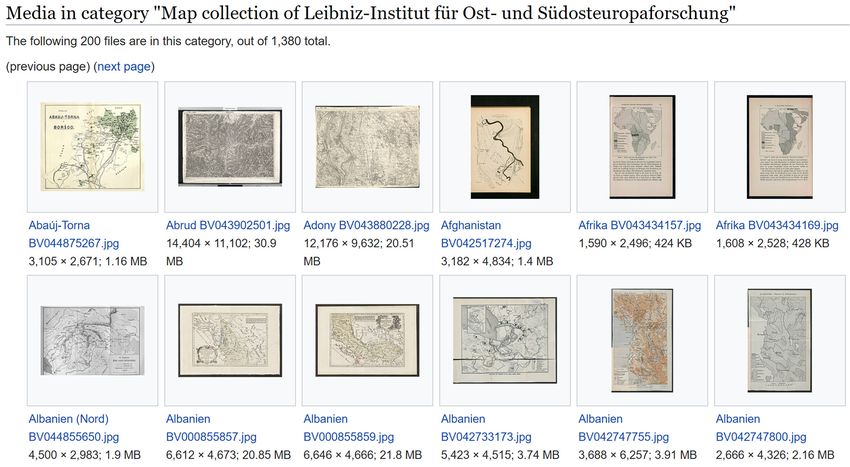
In addition, it should be noted that the set has been associated with numerous content
In addition, it should be noted that the set has been associated with numerous content
aggregators.
aggregators. ThanksThanks to this
to this description,
description, mapsmaps are available
are available via Online
via Online Public Public
Access Access
CatalogCatalog
(OPAC),(OPAC),
Wikimedia commons (Figure 3) [44], Karten Speicher (a network connecting resources
Wikimedia commons (Figure 3) [44], Karten Speicher (a network connecting resources from various from various
German
German libraries
libraries [15]),
[15]), DFG DFG Viewer
Viewer (eng.
(eng. GermanGerman Research
Research Foundation
Foundation Viewer,Viewer, German:
German: Deutschen
Deutschen
Forschungsgemeinschaft)
Forschungsgemeinschaft) [45], Wiki data [38], Georeferencer [13] or web apps that can simply use thisuse this
[45], Wiki data [38], Georeferencer [13] or web apps that can simply
map
map withwithwebweb map
map services,
services, and and Recogito
Recogito [46]. [46]. GeoPortOst
GeoPortOst is being
is being planned
planned to import
to import to old maps
to old maps
online
online [14].
[14].
Figure 3. Collection
Figure of Leibniz
3. Collection Institute
of Leibniz for East
Institute for and
EastSoutheast European
and Southeast StudiesStudies
European available via
available via
Wikimedia commons
Wikimedia commons[44].[44].
Further
Further research on on
research thethe
provision
provision of cartographic resources
of cartographic resourceswillwill
concern thethe
concern ontology of time
ontology of time and
and space
space in the
in the context
context of use
of the the ofuse
oldofmaps
old maps by historians,
by historians, geographers,
geographers, cartographers,
cartographers, and
and librarians [47].
librarians [47].
5. Conclusions
5. Conclusions
When describing maps, metadata should be divided into three groups. The first is administrative
When
data, i.e.,describing
metadatamaps, metadata
concerning should be
metadata. divided
These into three
metadata are groups.
collected The
in first is administrative
special databases that show
data, i.e., metadata concerning metadata. These metadata are collected in special
the kind of standards that were used to prepare particular metadata, and the relationship databases that show between
thedifferent
kind of standards that were used to prepare particular metadata, and the relationship
standards. The second are typical metadata for each object in a digital library, between
such as the
different
author,standards.
publication Thedate,
second
etc.,are
andtypical metadata
the third for each object
are cartographic in a digital
metadata, whichlibrary, such the
describe as the
character
author, publication date, etc., and the third are cartographic metadata, which describe the character
of maps. The answer to the first research question is as follows: the set of metadata to describe
of maps. The answer to the first research question is as follows: the set of metadata to describe maps
should contain typical metadata (the title, type, date, date range, rights, language, subject, and
distribution format) and cartographic metadata (the geographic location, scale, reference system,
mapping methods, map format, and, finally, information about the source).
It turns out that some collections are well described by typical metadata such as the title, type,
rights, and date. The Ethnodoc collection has the most complete metadata, while the GeoPortOstISPRS Int. J. Geo-Inf. 2020, 9, 444 11 of 13
maps should contain typical metadata (the title, type, date, date range, rights, language, subject,
and distribution format) and cartographic metadata (the geographic location, scale, reference system,
mapping methods, map format, and, finally, information about the source).
It turns out that some collections are well described by typical metadata such as the title, type, rights,
and date. The Ethnodoc collection has the most complete metadata, while the GeoPortOst collection
has the most correct cartographic metadata, including the geographic location and information about
the source.
Data that are completed in compliance with uniform rules are easier to make more interoperable.
This is what made it possible to link data from the GeoPortOst Project to other databases.
The evaluation allows for identifying good practices in collecting metadata, such as detailed
information about source material. The evaluation enables the owners to show the strengths and
weaknesses of a given collection in a quick and easy way. Additionally, it is possible to detect errors and
introduce quick/easy improvement. It may also indicate elements that can be used further, for example,
the width, height and geographic coordinates may be used to calculate the level of detail of a given map.
Author Contributions: Conceptualization, Marta Kuźma and Hans Bauer; methodology, Marta Kuźma; data
curation, Hans Bauer; formal analysis, Marta Kuźma, writing—original draft preparation, Marta Kuźma;
writing—review and editing, Hans Bauer. All authors have read and agreed to the published version of
the manuscript.
Funding: This research was funded by the European Social Fund under the "Operational Programme Knowledge
Education Development 2014-2020”, grant number POWR.03.03.00-00-PN13/18.
Acknowledgments: We are thankful to the anonymous reviewers for their insightful comments that helped us
improve the manuscript.
Conflicts of Interest: The authors declare no conflict of interest.
References
1. Godlewska, A. The idea of the map. In Ten Geographic Ideas that Changed the World; Hanson, S., Ed.; Rutgers
University Press: New Brunswick, NJ, USA, 1997; pp. 17–39.
2. Šolar, R. Map libraries—Challenges for the future. e Perimetron 2016, 11, 90–98. Available online: http:
//www.e-perimetron.org/Vol_11_2/Solar.pdf (accessed on 28 May 2020).
3. Laurini, R. Geographic ontologies, gazetteers and multilingualism. Future Internet 2015, 7, 1–23. [CrossRef]
4. Müller, F.; Schmunk, S. Bedeutung und potenzial von geoinformationen und deren anwendungen im kontext
von bibliotheken und digitalen sammlungen. Bibl. Forsch. Prax. 2019, 43, 21–34. [CrossRef]
5. Mościcka, A.; Zwirowicz-Rutkowska, A. On the use of geographic information in humanities research
infrastructure: A case study on cultural heritage. ISPRS Int. J. Geo-Inf. 2018, 7, 106. [CrossRef]
6. Kiser, T.; Smeltekop, N. A method for creating scanned map metadata for geoportals, library catalogs, and
digital repositories: Reworking existing MARC records of paper maps to create new records for their scanned
counterparts. J. Map Geogr. Libr. 2018, 14, 109–131. [CrossRef]
7. Weimer, K.; Andrew, P.; Hughes, T. Map, GIS and Cataloging/Metadata Librarian Core Competencies,
American Library Association 2008. Available online: http://www.ala.org/rt/sites/ala.org.rt/files/content/
publicationsab/MAGERTCoreComp2008.pdf (accessed on 28 May 2020).
8. Allen, M.M. Creating the virtual map drawer: Bridging the gap between spatial data infrastructures and
map libraries. OCLC Syst. Serv. 2008, 24, 153–159. [CrossRef]
9. Kowal, K.C.; Martyn, C. Descriptive metadata for digitization of maps in books: A British Library project.
Libr. Resour. Tech. Serv. 2011, 53, 108–120. [CrossRef]
10. Subirana, J.C.; Maganto, A.S.; Arranz, E.C.; Cortijo, A.A. Opening up the cartographic heritage of the Spanish
Geographical Institute by means of publishing standardized, inspire compatible metadata. Liber Q. 2013, 22,
345–357. [CrossRef]
11. Europeana. Available online: https://www.europeana.eu/ (accessed on 28 May 2020).
12. The Digital Public Library of America. Available online: https://dp.la/ (accessed on 28 May 2020).
13. Georeferencer. Available online: https://www.georeferencer.com/ (accessed on 28 May 2020).
14. Old Maps Online. Available online: https://www.oldmapsonline.org/ (accessed on 28 May 2020).ISPRS Int. J. Geo-Inf. 2020, 9, 444 12 of 13
15. Karten Speicher. Available online: http://kartenspeicher.gbv.de/index.php?id=3 (accessed on 28 May 2020).
16. Bernard, L.; Kanellopoulos, I.; Annoni, A.; Smits, P. The European geoportal—One step towards the
establishment of a European Spatial Data Infrastructure. Comput. Environ. Urban Syst. 2005, 29, 15–31.
[CrossRef]
17. Veenendaal, B.; Brovelli, M.A.; Li, S. Review of web mapping: Eras, trends and directions. ISPRS Int. J.
Geo-Inf. 2017, 6, 317. [CrossRef]
18. March, G.; Scarletto, E. The evolution of GIS services within North American academic libraries: Documenting
change through the decades (1995–2016). J. Map Geogr. Libr. 2017, 13, 222–245. [CrossRef]
19. Kuźma, M.; Mościcka, A. Metadata evaluation criteria in respect to archival maps description. Electron. Libr.
2020, 38, 1–27. [CrossRef]
20. GeoPortOst Project. Available online: http://geoportost.ios-regensburg.de/ (accessed on 28 May 2020).
21. Dempsey, L. Library collections in the life of the user: Two directions. Liber Q. 2016, 26. [CrossRef]
22. Flanders, J. Rethinking collections. In Advancing Digital Humanities: Research, Methods, Theories; Arthur, P.L.,
Bode, K., Eds.; Palgrave Macmillan: London, UK, 2014; pp. 163–174.
23. Stäcker, T. Die Sammlung ist tot, es lebe die Sammlung! Die digitale Sammlung als Paradigma moderner
Bibliotheksarbeit. Bibl. Forsch. Prax. 2019, 43, 304–310. [CrossRef]
24. Weber, J. Was ist eine Sammlung? ZfBB 2020, 67, 15–24. [CrossRef]
25. Curral, J.; Moss, M.; Stuart, S. What is a collection? Archivaria 2004, 58, 131–146. Available online:
https://archivaria.ca/index.php/archivaria/article/view/12480 (accessed on 28 May 2020).
26. Dimitrov, B. Quality evaluation methods—A review. Econ. Qual. Control 1998, 13, 117–128.
27. Kuźma, M.; Mościcka, A. Evaluation of the accessibility of archival cartographic documents in digital library.
Electron. Libr. 2018, 36, 1062–1081. [CrossRef]
28. Moen, W.E.; Stewart, E.L.; McClure, C.R. The Role of Content Analysis in Evaluating Metadata for the
U.S. Government Information Locator Service (GILS): Results from an Exploratory Study 1998. 1998.
Available online: https://digital.library.unt.edu/ark:/67531/metadc36312/ (accessed on 28 May 2020).
29. The Dublin Core Metadata Initiative. Dublin Core Metadata Element Set 2012, Version 1.1. Available online:
http://dublincore.org/documents/dces (accessed on 28 May 2020).
30. Cox, S.; Powell, P.; Wilson, A. DCMI Box Encoding Scheme: Specification of the Spatial Limits of a Place,
and Methods for Encoding this in a Text String 2005. Available online: https://www.dublincore.org/
specifications/dublin-core/dcmi-box/2005-07-25/ (accessed on 28 May 2020).
31. Library of Congress—Network Development and MARC Standards Office. MARC Standards 2019.
Available online: http://www.loc.gov/marc/ (accessed on 28 May 2020).
32. German Research Foundation. Available online: https://www.dfg.de/en/ (accessed on 28 May 2020).
33. Black, J. Maps and Politics; University of Chicago Press: Chicago, IL, USA, 1997.
34. Tegeler, T. Discovering hidden maps: Cartographic representations as arguments for historical narratives.
In Dissemination of Carto-graphic Knowledge. Proceedings of the 6th International Symposium of the ICA Commission
on the History of Car-Tography, Dubrovnik, Croatia, 13–15 October 2016; Altić, M., Demhardt, I.J., Vervust, S.,
Eds.; Springer: Cham, Switzerland, 2016. [CrossRef]
35. van Egmond, M. The Dutch landscape of online institutional georeferencing1. e Perimetron 2019, 14, 126–139.
36. Fleet, C. Creating, managing, and maximising the potential of large online georeferenced map layers.
e Perimetron 2019, 14, 140–149.
37. German National Library. The Integrated Authority File (GND) 2020. Available online: https://www.dnb.de/
EN/Professionell/Standardisierung/GND/gnd_node.html (accessed on 28 May 2020).
38. Wikidata. 2020. Available online: https://www.wikidata.org/ (accessed on 28 May 2020).
39. OpenRefine 2020. Available online: https://openrefine.org/ (accessed on 28 May 2020).
40. GeoPortOst SPARQL 2020. Available online: http://geoportost.ios-regensburg.de/sparql/ (accessed on
28 May 2020).
41. International Organization for Standardization. Standards by ISO/TC 211 Geographic Information.
Available online: https://www.iso.org/committee/54904/x/catalogue/ (accessed on 28 May 2020).
42. Lai, P.; Gillies, C.F. The impact of geographical information systems on the role of spatial data libraries. Int. J.
Geogr. Inf. Syst. 1991, 5, 241–251. [CrossRef]
43. German National Library. Available online: https://www.dnb.de/EN/Home/home_node.html (accessed on
28 May 2020).ISPRS Int. J. Geo-Inf. 2020, 9, 444 13 of 13
44. Leibniz Institute for East and Southeast European Research. Map collection of Leibniz Institute for East and
Southeast European Research, Wikimedia Commons 2019. Available online: https://commons.wikimedia.org/
wiki/Category:Map_collection_of_Leibniz-Institut_f%C3%BCr_Ost-_und_S%C3%BCdosteuropaforschung
(accessed on 28 May 2020).
45. German Research Foundation Viewer. Available online: https://dfg-viewer.de/en/ (accessed on 28 May 2020).
46. Recogito. Available online: https://recogito.pelagios.org/ (accessed on 28 May 2020).
47. Jannidis, F. Modeling in the digital humanities: A research program? Hist. Soc. Res./Historische Sozialforschung.
Supplement 2018, 31, 96–100.
© 2020 by the authors. Licensee MDPI, Basel, Switzerland. This article is an open access
article distributed under the terms and conditions of the Creative Commons Attribution
(CC BY) license (http://creativecommons.org/licenses/by/4.0/).You can also read