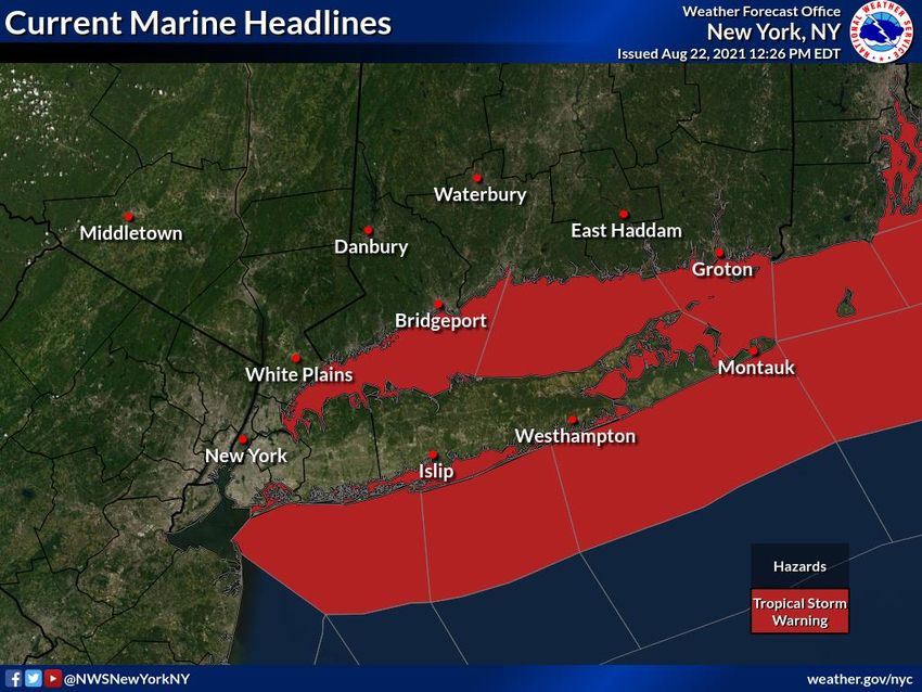
TROPICAL STORM HENRI BRIEFING - 1200 PM EDT Sunday, August 22, 2021 - National Weather Service - National Weather ...
←
→
Page content transcription
If your browser does not render page correctly, please read the page content below
National Weather Service
                                                                                            New York, NY

         TROPICAL STORM HENRI
               BRIEFING
                             1200 PM EDT
                         Sunday, August 22, 2021

         Next Briefing: Sunday, August 22, by 8pm EDT

Disclaimer: The information contained within is time-sensitive. Do not use after 8pm EDT Sunday.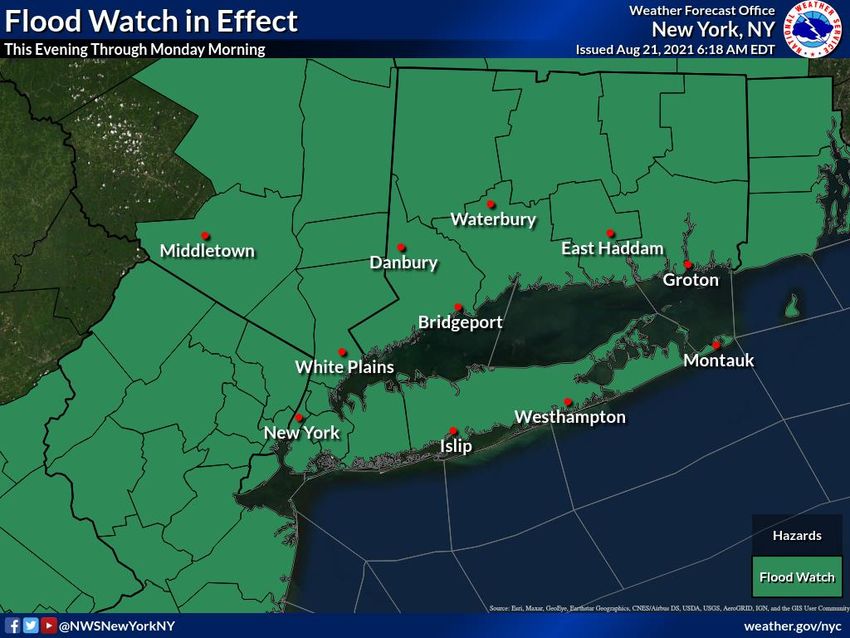
Situation Overview
Tropical Storm Henri
Current Headlines
Tropical Storm Warning for all of Long Island and S CT, and Westchester.
Storm Surge Warnings continue for N Queens and Bronx and northern and eastern portions of
Long Island, S Westchester, and S Ct.
What has changed?
Tropical Storm Warnings dropped for NYC and NJ
Hurricane Warnings downgraded to Tropical Storm Warnings
Storm Surge Watch for SW LI cancelled
Henri has weakened to a tropical storm with landfall expected to be across Rhode Island by early
afternoon.
The threat for hurricane conditions has ended, with tropical storm conditions still expected for CT and LI.
Flood Watch for the entire area has been extended through Monday evening.
Minor to locally moderate main stem river flooding across northeastern NJ, Lower Hudson valley and southwestern CT
is possible.
Last Updated: 8/22/2021 12:53 PM National Weather Service – New York, NY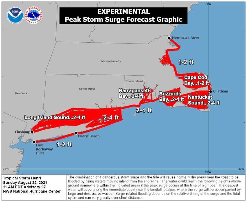
Situation Overview
Tropical Storm Henri
Tropical Storm Henri is expected to make
landfall in Rhode Island early this
afternoon and continue northeast into CT
while weakening into this evening.
Dangerous marine, rip current, and high
surf conditions through tonight
Flooding rainfall threat for the entire region
through Monday.
Damaging winds for far eastern portions of
the area.
Moderate to locally major storm surge for
NOTE: Do not focus on the exact track. portions of the coast.
Impacts can occur well outside the area enclosed by the cone.
Last Updated: 8/22/2021 12:53 PM National Weather Service – New York, NY
Flash Flood Threat
Hurricane Henri
Additional Rainfall forecast through
Monday.
4 to 6” with locally 8” for much of the Lower
Hudson Valley, CT, E LI and NE NJ
2 to 4” with locally 6” for southwestern
portions of area.
Max rainfall rates-
1-2”/hr
Timing-
Most widespread and torrential rainfall across
the entire area today shifting into NW portions
of the CWA tonight.
Then bands of heavy rain will works back
east through the areas on Monday.
Last Updated: 8/22/2021 12:53 PM National Weather Service – New York, NY
Flash Flood Threat
Hurricane Henri
Flood Watch in Effect for Entire Area
Timing-
Tonight through early Monday morning.
Impacts-
Widespread urban and poor drainage flash flooding
Potentially rising to considerable severity level.
Flash flooding of numerous small streams and creeks,
particularly in S CT.
Minor to locally moderate flooding on S CT main stem
rivers possible
Forecast Challenges-
Heavy rainfall axis will likely pivot and stall across the
NYC/NJ metro, Lower Hudson and SW CT tonight,
posing a considerable flash flood threat, before moving
eastward tonight.
Urban and poor drainage flooding will be exacerbated
during the times of high tide t and tonight in coastal
communities, including tidally affected riverine
communities.
Last Updated: 8/22/2021 12:53 PM National Weather Service – New York, NY
Damaging Wind Threat
Hurricane Henri
SE CT
Peak winds – 30-50 mph sustained with gusts 60-70 mph.
Likely duration – into early this evening.
Impacts – Widespread tree damage and power line damage likely.
LI, SW CT, and Westchester
Peak Winds - 25-40 mph sustained winds with gusts to 50 mph.
Likely duration – into this evening.
Impacts – Scattered tree damage and power line damage likely. Wind impacts could be on the same level of Isaias.
NYC, NE NJ, Lower Hudson Valley -
Peak Winds- 15-20 mph sustained winds with gusts 30 to 35 mph.
Likely duration – into this evening.
Impacts – Isolated tree damage and power line damage possible.
Last Updated: 8/22/2021 12:53 PM National Weather Service – New York, NY
Storm Surge Flooding Threat is Decreasing
                                                                      Along E LI bays, Twin Forks, LI Sound and ocean
           Tropical Storm Henri
                                                                      beachfront
                                                                      •   Moderate to locally Major inundation threat - 2 to 3 ft,
                                                                          locally 4 ft (AGL) in vulnerable spots, particularly
                                                                          through around 2pm.
                                                                            –   East end of Long Island, north shore of E LI, and north facing
                                                                                shorelines of the Great South Bay have the highest threat of major
                                                                                inundation
                                                                      Along the southern bays of LI
                                                                      •   Minor to Moderate inundation threat this evening– 1 to 2 ft,
                                                                          locally 3 ft. Highest threat across north facing shorelines of
                                                                          the barrier island.
                                                                      Along NY/NJ Harbor
                                                                      •   Minor inundation threat evening– Up to 1 ft.

                                                                      Timing of greatest concern-
                                                                      •   During This afternoon and this evening’s high tides

                                                                      Forecast Challenges
                        Values shown above are for inundation         •   The weaker and further east track has decreased the
                                                                          magnitude of the storm surge threat, but still locally life
                        above ground. No datum conversion required.       threatening surge.
                                                                      •   Hardest hit locations will be north facing shorelines of LI,
                                                                          the twin forks and ocean beachfront
                                                                      •   Storm surge, particularly in the eastern bay areas, may not
                                                                          fully recede after today’s morning/early afternoon high tide,
                                                                          before tonight’s evening/night high tide.
Last Updated: 8/22/2021 12:53 PM                                                       National Weather Service – New York, NY
Dangerous Marine and Shoreline Impacts
           Hurricane Henri

                                    Battering Surf at Ocean beachfront
                                    • Timing – through around 2am
                                    • Surf Height – 4-7 ft western LI beaches,7-11 ft
                                       eastern LI beaches
                                    • Impacts – Widespread dune erosion and localized
                                       overwashes are likely, particularly E LI and Orient
                                       point.

                                    Marine
                                    • Tropical storm conditions into tonight.
                                    • Ocean seas 8 to 12 ft on the ocean, east of
                                       Moriches Inlet.
                                    • Seas on Long Island Sound building to 4 to 7 ft
                                       today.

                                    Dangerous rip currents through Monday!

Last Updated: 8/22/2021 12:53 PM                 National Weather Service – New York, NY
Key Take-Aways
           Hurricane Henri

                  Considerable urban and small stream flash flooding threat through Monday. Minor to moderate
                  flooding possible along large stem rivers.

                  Damaging winds across SE CT into early this evening. Widespread tree and power line damage .

                  Moderate to locally Major inundation threat across vulnerable coastal locales along eastern LI
                  bays/Twin Forks, most of LI Sound and ocean beachfront into next high tide.
                  Dangerous rip currents and high surf building through tonight.
                  Widespread dune erosion and localized overwashes along ocean beach front.

                  Dangerous marine conditions expected across the coastal waters into tonight.

Last Updated: 8/22/2021 12:53 PM                                                 National Weather Service – New York, NY
Next Briefing:
Sunday 8:00 PM EDT
Method: [Email]
www Web: http://weather.gov/nyc Facebook: NWSNewYorkNY
Phone: (631) 924-0517 Twitter: @NWSNewYorkNY
E-mail: okx.spotters@noaa.gov YouTube: NWSNewYorkNY
For the latest graphics and information go to: www.hurricanes.gov or weather.gov/okx/tropicalYou can also read