An update on an imperial building complex at the 16th mile of the Via Appia: sources and materials
←
→
Page content transcription
If your browser does not render page correctly, please read the page content below
Layers
8, 2023, 163-185 (ISSN 2532-0289)
An update on an imperial building complex at the
16th mile of the Via Appia: sources and materials
Giulia Moretti Cursi
Abstract: The paper focuses on an area of the Ager Aricinus at the 16 th mile of the Via
Appia in the urban area of Ariccia between the Via Appia and the inhabited center,
delimited to the west and north by the cell of the so-called temple of Diana. Inside the
aforementioned area, now almost entirely urbanized, are still preserved some structures
from the mid-2nd century AD for which extensive documentation can be found in the 18th
century antiquarian sources and in the cartographic reproductions between the 19th and the
20th centuries. So far, their interpretation has gone through a plurality of hypotheses
(amphitheatre, thermal building, statio) for which there is a need to undertake an analytical
study in order to understand its function in antiquity and its impact in the landscape
context of modern age. The study will take place in two phases: examination of the
historical cartography to identify the ownership of the fund on which the structures
insisted through the consultation of the Collections of drawings and maps at the State
Archive of Rome and the realization of a graphic restitution of the plan, integrating what
has been preserved and what has been handed down from past documentation and
proposing a vector reconstruction (CAD) of the building.
Keywords: Ager Aricinus, Roman amphitheatres, historical cartography.
Riassunto: L’intervento prende come focus un’area dell’Ager Aricinus al XVI miglio della
Via Appia nell’area urbana di Ariccia compresa tra la Via Appia e il centro abitato,
delimitata a ovest e a nord dalla cella del cosiddetto tempio di Diana. All’interno della
suddetta area, ora quasi interamente urbanizzata, sono ancora conservate alcune strutture
della metà del II secolo d.C. per le quali si rintraccia un’ampia documentazione nelle fonti
antiquarie del XVIII secolo e nelle riproduzioni cartografiche tra il XIX e il XX secolo.
Finora la loro interpretazione è passata attraverso una pluralità d’ipotesi (anfiteatro, edificio
termale, statio) per le quali si avverte l’esigenza di intraprendere uno studio analitico al fine
Paper presented at the n° 183 Session ‘Ideas across times. Cultural interactions in the central-western Mediterranean Sea from
the 7th century BC to the Late Roman Age’ of the 26th Annual Meeting of the European Association of Archaeologists (EAA,
2020 Virtual ‘Networking’), organized by Prof. Carla Del Vais, Prof. Marco Giuman, Dr. Ciro Parodo, Dr. Gianna De
Luca (University of Cagliari, Department of Humanities, Languages and Cultural Heritage) and Prof. Dominique Frère
(University of Southern Brittany, TEMOS Laboratory, CNRS, UMR 9016).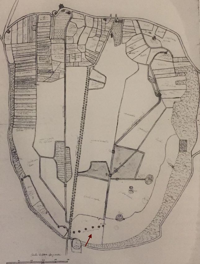
G. Moretti Cursi, An update on an imperial building complex at the 16th mile of the Via Appia

di comprenderne la funzione nell’antichità e l’impatto nel contesto paesaggistico di età
moderna. Lo studio si svolgerà in due fasi: esame della cartografia storica per identificare la
proprietà del fondo su cui insistono le strutture tramite la consultazione della Collezione I e
II dei Catasti e delle Collezioni di disegni e mappe presso l’Archivio di Stato di Roma e la
realizzazione di una restituzione grafica dei resti, integrando quanto conservato e quanto
tramandato dalla documentazione del passato e proponendo una ricostruzione vettoriale
(CAD) dell’edificio.
Parole chiave: Ager Aricinus, anfiteatri romani, cartografia storica.

LITERARY EVIDENCE OF THE 18TH-20TH CENTURIES
The history of the research and excavations that involved Ager Aricinus is dense and full of
elements of interest that allow us to open a glimpse into the 18th century scholarly
landscape. In the wake of the broad antiquarian tradition of the village, which matured
already in the 16th century1 and made even more solid in the 18th century thanks to to the
influx of writers and scholars into the orbit of the Chigi family2, emerges the figure of the
curate of Ariccia Emmanuele Lucidi3, author of the volume Memorie dell’antichissimo municipio
ora terra dell’Ariccia, published in 17964. Lucidi’s work collects a large amount of data and
information on the history of studies, physical geography, and historical-literary sources of
the city of Ariccia, many of which are based on the direct vision of ancient remains and
buildings.

1 LUCIDI 1796: 228; LEFEVRE 1973: 82; BLONDUS FLAVIUS 2011: 66. A further reference to the ruins and
ancient buildings that can be found along the ancient Via Appia from Albano to Genzano is found in the
Commentaries of Pius II Piccolomini (1462): «hinc pontifex Albam redit et sequenti die ad visendum lacum
Nemorensem [...] sese contulit, Appia via profectus quae adhuc strata cernitur [...] Antiquae ruinae ad sinistram a monte
mansere, sub quo reliquae veterum cernuntur aedificiorum, quas Bovillas [?] dicunt» (PASCHINI 1933: 50; BONOMELLI
1953: 155; LEFEVRE 1975: 82-83; TOTARO 1984: 307-308). Finally, we know that the Neapolitan architect and
painter Pirro Ligorio (1510-1583) also claimed the discovery, in the territory of Ariccia at the time of the
Cardinal Ippolito d’Este, «statua nobile di Esculapio sopra un piedistallo rotondo di bianco marmo», of a marble
decorated around with the inscription «M. Tarchetis M.A. Priscus – Eq. Romanus – Dianae Aricinae – Bonae Deae
D.D.» and other related inscriptions related to Diana Aricina, to the Collegium Lotorum and to the Flamines
Virbiales (PRATILLI, STRINA 1745: 79). For a hypothesis on the location of the statue of Aesculapius in the
project carried out by Pirro Ligorio for the villa of the Cardinal Ippolito d’Este in Tivoli, see GIANNETTI
2019: 50.
2 They took possession of the fief of Ariccia from the Savelli family in 1661, starting a complete renovation

of the village.
3 He was born in Ariccia on 15 August 1734 to Paolo Lucidi and Maria Maddalena Malcelli. After completing

his studies in the seminary and embracing the priesthood, he obtained in 1755, through the intercession of
Pope Benedict XIV, the appointment as canon of the ‘distinguished collegiate and parish church of S. Maria
Assunta’. In 1780 he obtained the position of archivist of Ariccia providing for the administration of the
baronial curia, including the acts of the local notaries and the acts of civil and criminal jurisdiction. He also
held the office of governor of Ariccia. He died in Ariccia on November 29, 1798 (LEFEVRE 1975: 149-154).
4 Despite the importance of the work for the study of the territory of Ariccia from the historical point of

view, it is not unique from a literary point of view but presents several previous examples: MATTEI 1711;
RICCI 1787; RANGHIASCI 1792.

164
Layers
8 (2023)

In particular, what interests us here is the mention of an excavation carried out in the
vineyard of Paolo Minimi in 1791. This excavation is part of the second of three campaigns
conducted between 1789 and 1792 by two personalities from the cosmopolitan world of
Rome: Antonio Despuig y Dameto, a native of Palma de Mallorca and Auditor of the Sacra
Rota for the Crown of Aragon, and Alessandro de Souza Holstein, count of Soufré and
plenipotentiary minister of Portugal to the Holy See.
For an overview of the Minimi vineyard5 mentioned above, please refer to a 17th century
map preserved in the Chigi Archive6 (Fig. 1). In this map it is possible to see the path of
the ditch that led the water from the emissary of Lake Nemi and the adjacent to the Alberti
vineyard, a place close to the Via Appia from which the explorations of the Majorcan
cardinal had begun.
These excavation campaigns also saw the involvement of a trusted person of Despuig: the
prelate, also Majorcan, Felix Lobo7 who, in two autographed letters of 17918, notes the
discovery of some structures which, due to their conformation and orientation, could be
identified with a circus and a scaena.
From Lucidi’s work we learn that:

«Più oltre della vigna d’Aste vi è quella del canonico D. Paolo Minini. [...] Ivi si scuoprì un grande atrio,
o cortile di magnifico edifizio. È questo largo palmi 129, lungo palmi 141, e di figura quadrangolare. Sotto

5 The excavation undertaken by Despuig in the Minini vineyard, on the right side of the Via Appia at the
sixteenth mile, proved to be a harbinger of many ancient materials, including three significant tombstones,
respectively to Tiria Quintilla (SOLER 2011: 177-179, n. 57), L. Sempronio (SOLER 2011: 174-176, n. 56) and
Licinia Bassilla, as well as various feminine toiletry objects, a sepulchral stone by T. Flavio Abascante, a
female sculpture identified with a Venus and a small marble head (LUCIDI 1796: 214; DOMÍNGUEZ RUIZ
2017: 20-21).
6 For further information, see: LILLI 2002: 19-34; MOLTESEN 2003: 244-246; BIGNAMINI, SEKUL HORNSBY

2010: 111; PASQUALINI 2003: 302; CACCIOTTI 2019: 355.
7 The biographical information attributable to this character is meager. He is mentioned in the work of J. M.

Bover (1868: t. 1, 411) as the son of Félix Lobo y Arjona, a soldier from a noble family from Extremadura
based in Mallorca (DE SALAZAR 2001: 555), and the Majorcan Margalida da Llull. He devoted himself to an
ecclesiastical career becoming a doctor in theology, apostolic protonotary and postulator of the cause of
beatification of Sister Caterina Tomas. In 1768 he translated the Instructions pour les dimanches of the bishop of
Soissons and in 1782 he published a brief history of the Jews and the Christian religion dedicated to General
Ricardos, director of the military cavalry college of Ocaña. He died in Mallorca in 1810 (CARBONELL 2013:
113-114).
8 Both letters are dated to 1791 and confirm, in different ways, the archaeological materials mentioned, for

the same year, by E. Lucidi. The first letter (ARM, Archivio Marquès de la Torre, cardenal Despuig, XII/20
in SOLER et alii 2001: 30) refers to the discovery of a finely draped headless female statue, for which Lucidi
proposes identification with a Venus (LUCIDI 1796: 214), a small animal head in marble and an inscription in
peperino (LUCIDI 1796: 214). The second letter (ARM, archive marqués de la torrem cardenal Despuig,
Legajo XII, pliego 20 in CARBONELL 2013: 127) refers more specifically to the excavation of the so-called
amphitheatre, focusing on the impossibility of providing precise measurements of the structure as it is on the
east side of the building the wall is broken.

                                                                                                              165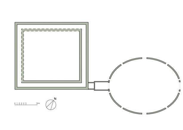
G. Moretti Cursi, An update on an imperial building complex at the 16th mile of the Via Appia

il piano dell’atrio vi è una volta retta dal muro maestro, e da un altro muro, distante uno dall’altro palmi
9, che gira intorno a tutti i quattro lati. Accanto al secondo muro della volta in distanza di palmi tre vi è
altro muro, che regge un’altra piccola volta. Non sappiamo, se questo corridore giri intorno a tutto il cortile,
perchè non è stato tutto aperto, ma solamente una piccola porzione. In un angolo attaccato al muro della
parte esterna del cortile vi è una stanza quadrata di palmi dodici. Sul principio dello scavo si trovò uno
scheletro di uomo incatenato con catena di ferro tutta irrugginita. Sul fine del muro del cortile nella
medesima linea, in cui è la stanza, e distante dall’angolo palmi 20 vi sono due muri, che reggono una volta,
che sta al medesimo piano del cortile e delle altre volte, in distanza uno dall’altro palmi 16 di larghezza, e
palmi 27 di lunghezza. Questo andava sotto la porta di un anfiteatro. Dovea pertanto anche al di sopra
esservi la medesima strada, che introduceva all’anfiteatro, la quale è larga palmi tredici e mezzo.
L’anfiteatro è di figura ovale, di lunghezza palmi 144, e di larghezza palmi 112. La porta grande, che sta
incontro alla suddetta è larga palmi 16. Oltre queste due porte grandi ve ne sono altre 10 piccole distribuite
in questa maniera: accanto alle due porte grandi vi è da ambe le parti il muro di lunghezza palmi 4, indi
viene una porta di larghezza palmi 4, prosiegue il muro in lunghezza di palmi 41, e dipoi altra porta larga
palmi 5: in seguito continua il muro in lunghezza di palmi 45, e appresso di questo altra porta larga palmi
5, la quale sega nel mezzo il diametro della larghezza dell’anfiteatro. Da ambedue i pilastri delle due porte
grandi sono tirati due muri per tutta la lunghezza della fabbrica, e formati con molti pilastri di pietre
grosse: nelli muri si vedono i buchi, ne’ quali stavano le travi, che reggevano il pavimento superiore, o sia
l’arena dell’anfiteatro, e in questo luogo fu trovata gran quantità di chiodi di ferro ed altri ferri»9.

As can be seen from the text, the analysis of the environment defined as ‘large atrium, or
courtyard of a magnificent building’ is followed by a detailed exposition of the measures,
ordered according to the west-east longitudinal axis (Tab. 1)10.
On the basis of the aforementioned description, a structure consisting in two main bodies
emerges: the first has a square shape, while the second has an oval shape, connected by a
corridor preceded, in the initial section, by a square room of reduced dimensions (Tab. 2).
The identification of the oval space with the amphitheatre is proposed by Lucidi in two
points. Firstly, in the passage in which he describes the connecting element between the
two main buildings, and in the following explanatory section with the addition of the
referred measurements (Tabs. 3-4) and finds of which, unfortunately, the current
destination and conservation is unknown:

9 LUCIDI 1796: 214-215.
10 Here it has been preferred to report the measurements taken from the notes or from the discussions
reported by the two scholars (Lucidi and Zoëga) in palms with the equivalent in meters in brackets. As it will
be noted, the measurements are not congruent and show slight differences in computation due, in part, to the
difficulty of standardizing the metric scales used by the two scholars and, in part, by the use by both of
measurement methods not based on empirical data but deduced from field observations.

166
Layers
8 (2023)

«Sotto la piccola porta a mano destra della porta grande dell’anfiteatro vi fu trovata gran quantità di ossa e
di mascelle e denti di animali feroci. Tengo presso di me un grosso dente dentro la sua mandibola, che Mr.
de Jonville mi dice essere di un Ippopotamo, e simile ad altri da lui venduti in Egitto. Fu trovata ancora
nello scavo una iscrizione in sasso albano, che diceva:
                                                      SPQ
                                            ARICINUS TEA..
                                               AUG DEDIT
cioè Senatus Popolusque Aricinus Templum, ovvero Teatrum Augusto Dedit. Vi fu trovato anche un
frammento in marmo di una iscrizione, in cui leggesi:
                                                    ..OSA..
                                                ..AES.AN...
                                                    AUG..
                                                   ..MOD..
                                                      PM
Le lettere della prima linea sembrano inesplicabili: ma le altre chiaramente dicono: Caesari Antonino
Augusto Commodo Patrono Municipii. Dentro l’anfiteatro vi furono trovate alcune medaglie spettanti ad
Adriano, a M. Aurelio, a Faustina di lui moglie, e 4 a Commodo, in una delle quale di mezzana forma
vedesi la testa laureata di Commodo con barba lunga, e con la leggenda intorno COMMODUS
ANTONIN il resto è corroso: e nel rovescio vedesi un elefante, sotto del quale leggesi IIII PP, e la
leggenda intorno è tutta corrosa»11.

It is interesting the mention of the bone remains of animals, among which evidence is
given to the hippopotamus tooth, an animal documented in historical sources from the late
Republican12 and Imperial13 ages for its use in the games of the capital.
Lucidi then continues with an excursus, supported by the bibliography of the time, to
perform a comparative analysis between the aforementioned amphitheatre and the other
then known amphitheatres: the amphitheatre of Pola, the Colosseum and the arena of
Verona14.

11  LUCIDI 1796: 216. Unfortunately, there is no information about the current conservation of the finds
described with the exception of the axis of Commodus, identified in the RIC III 397 type.
12 During the games celebrated by M. Scauro, both animals from Egypt were used, including hippos and

crocodiles, and others probably coming from Syria, where Scaurus stayed both as Pompey’s lieutenant and as
provincial governor from 65 to 59 BC (Pliny, Hist. Nat. VIII, 17, 64; VIII, 26, 96; DE GROSSI MAZZORIN et
alii 2005: 340).
13 In 148, during the principality of Antoninus Pius, elephants, jackals, crocodiles, rhinos, hippos, tigers, and

lions performed in the arena of the Colosseum (Scriptores Historiae Augustae, Antoninus Pius, 10; DE GROSSI
MAZZORIN et alii 2005: 343).
14 LUCIDI 1796: 216: «Da quanto però si è trovato, sembrami potersi dedurre, che questa fabbrica servisse ad uso di anfiteatro.

Le misure veramente corrispondono più a quelle del Colosseo e dell’arena Veronese; e ciò potrebbe per avventura far sospettare,

                                                                                                                          167
G. Moretti Cursi, An update on an imperial building complex at the 16th mile of the Via Appia From the critical reading made by the curate, an interesting question emerges: the shape of the Roman amphitheatres. Despite the existence, already at the time, of some theories15 in this regard, the degree of caution adopted by the author in the identification of the amphitheatre on the sole basis of the oval rather than circular shape of the building is evident. The measurements provided by him would also find partial confirmation in the letters of the Danish scholar Georg Zoëga (1755-1809) which offer valuable information about the excavation campaigns carried out in the Roman countryside in the last decades of the 18th century16. In particular, as regards the structures found in Vallericcia, the news and the data he collected are based on direct knowledge of the remains. In one of his letters addressed to F. Munter17 and dated December 3, 1791, Zoëga himself confirms what Lucidi saw, noting slightly different numerical information in the size of the axes (Tab. 5). The difficult understanding of the structure, as well as its functional interpretation, have been the subject of various readings throughout the history of studies. In the itinerary compiled by A. Nibby18 in 1819 we find a similar mention of the alleged amphitheatre with regard to some brick structures south-east of the temple of Diana, on the right side of the Via Appia. While formulating the hypothesis of their belonging to the Julio-Claudian age, defining them as ‘well manufactured’, he does not provide any information about their possible functional interpretation. che in vece di anfiteatro fosse teatro, come il lodato Maffei prova di quello di Pola; ma le misure non decidono. La forma piuttosto non circolare, ma ovale potrebbe caratterizzarlo più per anfiteatro, che per teatro, cui gli antichi davano comunemente la figura semicircolare perfetta, ed anche la circolare intera, come provò il Poleni, comprendendo nel recinto l’orchestra, la scena, e tutto ciò, che formava l’antico teatro. Ciò però comunemente, ma non costantemente si costumava, come vuole il ch. signor Milizia; perchè l’opinione suddetta del Maffei ne è un’esclusiva. Che gli anfiteatri poi si costruissero anche in forma esattamente rotonda, lo dice il lodato signor Milizia ed altri; onde anche la forma non decide. Da questi indizi dunque cotanto dubbii non può dedursi una sicura conseguenza per l’anfiteatro». 15 Below there are some key passages taken from the works cited by Lucidi in support of his theory about the identification of this building with an amphitheatre: POLENI 1735: 43: «Ma non potrà dirsi perciò un teatro circolare tutto all’intorno: poiché quel cerchio esteriore sarebbe una giunta al teatro, senza la quale ancora non lascierebbe di essere teatro, come difatto è. Altrimenti anche il nostro teatro Olimpico dovrebbe dirsi di quadrata figura, e non semielliptica, come è: giacchè la fabbrica esteriore che chiude esso teatro, è di quadrata figura. Onde al di fuori non mostra di esser teatro, ma Palagio. Il che non è stato volontà del nostro Architetto, ma necessità, come ho detto al principio del capo ultimo del mio discorso. E però la differenza degli antichi teatri dagli Anfiteatri, non è solamente per l’uso, ma anco per la figura». MILIZIA 1822: 30: «Significa teatro d’ogni intorno, o sia due teatri uniti insieme, dove gli spettatori disposti circolarmente veggono tutti ugualmente bene. Teatro vuol dire guardare ed era dà latini detto visorium. L’anfiteatro era un edificio spazioso ordinariamente ovale, in cui la piazza del mezzo, arena, era circondata di più ordini di gradini gli uni su gli altri con portici interni ed esterni. Era destinato ai combattimenti dè gladiatori, delle bestie feroci, e ad altri generi di giuochi e di spettacoli, e fin alle naumachie, cioè a combattimenti navali». 16 CACCIOTTI 2015: 237-247. 17 ANDREASEN, ASCANI 2013: 147-152, 538-539. 18 NIBBY 1792. 168
Layers
8 (2023)

Other references concerning the same area can be found in the graphic documentation
created by L. Canina19 in the second half of the 19th century. The latter, in 1854, refers to
the existence, on the right side of the Via Appia and in the same place indicated a century
earlier by Lucidi, of some brick remains. He attributes the good workmanship of those
remains to a ‘noble building’, of which «nulla può essere stabilito sulla sua rilevanza e
destinazione»20 (Fig. 2).
Both scholars insist on the brick technique of the raised walls, an element on which we will
return later to understand the connection between the remains described by Nibby and
Canina and the environments reported by Lucidi.
At the end of the 19th century, in Ms. 85/1 kept at BiASA21 library in Rome, Lanciani
follows the topographical representation with a detailed list of the archaeological structures
found within the town of Ariccia and in its extra-wall territory. Within this list, under the
heading AMPHITHEATRUM, it reports: «a Despuig effossum a. 1791. Vide quod disseret
de eo Lucidi pp. 104, 126, 214» (Fig. 3).
About half a century later in the same place described by Lucidi, G. Florescu22 indicates the
presence, on the right side of the Via Appia in the former Laurenti garden, of masonry
remains of which he provides the relative descriptions and interpretations. In this regard, it
is striking how the scholar takes up the topographical indications of Lucidi on the location
and identification of the aforementioned amphitheatre. Adding, however, that all that
remained visible in his time was nothing more than a quadrangular corridor and that, in the
absence of the other elements described by Lucidi, the presence of an amphitheatre here
could only be hypothesized23. At the time of Florescu the corridor described was covered
with earth both in the upper part, for a height of about 0.50 m from the thrust of the vault,
and in the lower part, up to 1.5 m in height on the walls side24 (Fig. 4).
According to his report, continuing in a north-west direction with respect to the
aforementioned structures, we reached a point where the ground showed a greater height
than the rest of the city, detecting a conspicuous quantity of masonry fragments between
the vine trunks which he considered as the remains of a building of considerable extension

19 Some hints are also present in NIBBY 1792-1839: 158; CANINA 1854: 105-106, tav. IX of the Via Appia;
CANINA 1856: tav. LXII; Lanciani CVatLat. 13045, 165r; Lanciani mss. 85/1, 167; Pietro Rosa, Archivio
Storico di Palazzo Altemps, inv. 3286 cass. 9/2 cart. A dis. 638. Other brief indications can be found in
COARELLI 1981: 96.
20 CANINA 1856: 106.
21 It is a series consisting of 5 manuscripts numbered from 84 to 88 bis dated to the end of the 19th century,

mostly autographs by Lanciani, which together form the Codex topographicus Urbis Romae ab aevo Constantiniano
ad finem saeculi XVI. Composuit R. Lanciani divided into two parts, the first concerning the city of Rome and
the second the districtus Urbis.
22 FLORESCU 1925: 31-32.
23 The elements on which this hypothesis is based are, on the one hand, the proximity to an important

communication route (the Via Appia) and, on the other, the presence, to the east, of the municipality of
Ariccia (SOMMELLA, MIGLIORATI 1988: 198; LILLI 2002: 77-78).
24 FLORESCU 1925: 33, tav. I n. 5.

                                                                                                          169
G. Moretti Cursi, An update on an imperial building complex at the 16th mile of the Via Appia and architectural grandeur. The entrance to the corridor had been made possible at the time through a hole made in the wall by the owner of the land to obtain a storage room for garden tools. However, Florescu himself, while acknowledging the hypothesis of the amphitheatre as valid and noting the unevenness of the ground and the irregularity of the ground, does not dwell further on the interpretation of the remains. He rather prefers to devote himself to the observation of another large brick building, between via delle Vignole to the east and via di Mezzo to the west, on which we will return later. VECTORIAL PROJECT HYPOTHESIS: COMPARISONS AND CRITICALITIES The geographical area in which the remains of the so-called Ariccia amphitheatre are located extends in the southern quadrant defined by the second wall circuit of the ancient Ariccia, built, presumably, in the 3rd century BC25. The initiative to promote this extra-urban sector, between the current via di Mezzo to the north-west and via di Valle Ariccia to the south-east, is probably one of the measures taken after the granting of Roman citizenship26. Two segments of the southern part of the walls that are of interest here remain: the first, to the south east of the area where the so-called amphitheatre stood in the segment between via delle Vignole and the Palombara tower, marked by conspicuous remains on the ground, and the second, north of the so-called amphitheatre, characterized by scarce remains on the ground, except for the sections that reach the brick remains mentioned above and then continue on the western side of the town. 25 The new city walls seem to coincide almost for the entire perimeter with some property limits marked in the Gregorian cadastre map of the early 19th century as also observed by Lanciani himself, who surveyed and described the entire route (Lanciani mss. 85/1, 167). Unfortunately, in the case of the map of Ariccia (n. 13), the relative brogliardo containing the descriptions of the cadastral parcels was never paid to the State Archives of Rome, by the Technical Tax Office, and, consequently, it is impossible to trace a correct location on the land by having only the name of the tenant or the owner of the land. The payment in question took place in 1988 and consisted of two organic series of cadastral documents – one containing large-format maps at a scale of 1/2000-1/1000 and the other in reduced maps at a scale of 1/8000-1/4000 – both integral part of the archive of the General Presidency of the census, established in 1816 as an operational technical body that collaborated between 1817 and 1838 in the realization of the Cadastre together with the corresponding management body (ZANGHERI 1980: 61-63; SPAGNUOLO 1995: 5-96). 26 Liv. VIII, 13 (ed. BLOCH, GUITTARD 1987: 33-35). On a possible historiographical interpretation of the passage, see also TOYNBEE 1965: 130-136; HUMBERT 1978: 176-195; SHERWIN-WHITE 1973: 58-65. In the passage from Livy, reference is made, first of all, to the episode of 416 BC. in which the Aricini, together with the inhabitants of Lavinio and Velletri, were attacked and defeated by Caio Menio near the river Astura. In the next paragraph (Liv. VIII, 14, 4) the historian, analyzing the consequences of the Roman victory case by case, attributes it to 338 BC. – the final year of the Latin War – the conferral of Roman citizenship on the Aricini, Nomentani and Pedani with the same rights as the Lanuvini. Controversial among scholars is the debate on the form of citizenship received by the Lazio center as, if on the one hand Cicero (Cic. Balb. 13, 3 and Cic. Phil. 3,6, 15 - Paolo Festo - Paul. 155 ) and Valerio Massimo (Val. Max. VIII, 2, 4) inform us about the acquisition of a Roman civitas with full rights according to the municipium optimo iure formula, according to other scholars it first became a civitas sine suffragio and, only later to his inclusion in the Horatia tribe, a municipality with full powers (LILLI 2002: 82). 170
Layers
8 (2023)

In the wake of the urban renewals, the eastern sector of the upper city and the entire
surface below were affected by an initial rationalization of the spaces, which provided for
the construction of some buildings at the same time as the opening of new economic
circuits included between the area upstream and downstream of the inhabited centre.
It is in this context that the construction of the monumental complex of the so-called
amphitheatre takes place. In support of the presence of the amphitheatre we could
consider, in the absence of visible material remains and direct literary sources27, the extra-
urban position of the walls described by historical cartography and their arrangement on
the ground. The latter, which can be deduced from the archaeological map 28, is given by
the analysis of the level curves which, at the point indicated by Lucidi, assume a curvilinear
pattern that suggests the existence of a circular or elliptical structure (Fig. 5).
Based on the data provided by the curate, it was possible to create a CAD plan, from which
an oval structure emerges that could lead to a small amphitheatre with a total capacity of
about 1100-1200 spectators (Fig. 6). In this reconstruction only the structures mentioned in
the literature are reported, the evidence of which on the ground is only partially verifiable.
From the data obtained and proposed, it is possible to trace the perimeter of the podium
wall and of the quadrangular space behind it, which is connected to the arena by a
quadrangular corridor. The evidence regarding the wall structures for accessing the arena
and supporting the spectators – division into sectors and stands – is completely non-
existent.
The aforementioned calculation of spectators is based on a census of 20 amphitheatres of
which the following reference measurements have been made known: length of the
amphitheatre, width of the amphitheatre, length of the arena on the major axis, width of
the arena on the smaller axis, width of the auditorium, extension of the perimeter29, width
of the intercolumniation, width of the open arches along the perimeter and width of the
pillars around the perimeter. However, with respect to the nine numerical parameters
expressed above, in the case in question we only have the first two relating to the length of
the axes.
Unfortunately, none of the amphitheatres known so far has characteristics that can be
reconciled with the presumed Ariccia amphitheatre as the measured dimensions are
significantly lower, both in terms of the size of the axes and their ratio30. Another critical

27 Liv. XXX, 38, 9; Iuv. IV, 117; Val Max. VIII, 2, 4; Symm. ep. 7,6; Pers. VI, 54; Mart. II, 19, 3 e XII 32, 10.
28 LILLI 2001: 79, fig. 26.
29 Studies on Roman amphitheatres are manifold. Here we will remember that of GOLVIN 1988: 387 and

WILSON JONES 1993: 391-394. Both studies, in addition to constituting a milestone for the architectural
reconstructions of Roman amphitheatres, constitute real databases for the acquisition of quantitative
numerical data on the internal and external dimensions of the architectural and structural elements. WILSON
JONES 1993: tab. 32, 441.
30 The smallest amphitheatre in size, among those presented, is that of Pola which presents, in its first phase,

an axis width of 123 and 96.5 with a ratio of 1.3 against 31.02 and 22 of that of Ariccia with a ratio of 1.4. A

                                                                                                             171
G. Moretti Cursi, An update on an imperial building complex at the 16th mile of the Via Appia issue, raised by the CAD reconstruction, was that of attributing a numerical value to the wall thickness of the rooms described by Lucidi. In fact, in its description there is no data that can be referred to. In the vectorial plan proposed here it was therefore chosen to attribute a thickness of 0.5 m in order to confirm the data, also provided by Lucidi, about the existence of a second floor above the quadrangular building that preceded the so-called amphitheatre31. This measure was deduced by analogy with the external portico of the Ludus Magnus, connected to the Flavian amphitheatre through a similar corridor that started from the external corner of the masonry, which has a thickness of about 1.5 m to support three floors. The first room described by Lucidi could correspond to a Ludus Magnus, connected to the presumed amphitheatre via a corridor that is neither in line with the major axis of the oval building nor with the axis of symmetry of the quadrangular one, creating a planimetric anomaly of doubtful attribution and not comparable with other known examples. As regards the question of the shape of the amphitheatre, the only possible alternative is that of proposing an oval construction, starting from the measures of the axes that were not in contradiction with the age-old geometric, issues concerning the definition of the geometric shape of the Roman amphitheatres32. Remaining in the field of hypotheses and considering as critical elements both the peculiar oval shape of the building and the lateral and non-central position of the connecting corridor between the so-called amphitheatre and the quadrangular environment, we will illustrate two other possible functional interpretations. The first provides for the existence of a logical connection between the so-called amphitheatre and the brickwork remains mentioned in the previous paragraph. The latter seem to refer to a quadrangular building with four semi-circular compartments at the corners and a rectangular cistern, repeatedly reported in historical maps33 and located north comparison is proposed with the amphitheatre of Pola as it is the only one with reduced dimensions and, consequently, more in keeping with the comparison with the wall structures found in Ariccia. 31 SERRA, TEN 2013: 207. 32 According to SALATI 2014: 69 in the construction of the amphitheatre the Roman architects tended to prefer the oval to the ellipse also in relation to proven planimetric data; Wilson Jones as part of his study (which concerns amphitheatres built in the imperial age such as: Pola, Verona, Rome, Pozzuoli, Nimes, Arles, Capua, Salona, Italica, El-Jem) verified that in all cases studied the rings cavea are perfectly concentric (in the Colosseum the space is only 4 cm) and therefore the shape of the latter can only be an oval: WILSON JONES 1993: 398; MORACHIELLO, FONTANA 2009: 180-204. 33 The building also appears in the drawings of Pietro Rosa, divided between the Historical Archive of the Special Superintendence for Archaeological Heritage of Rome (Pietro Rosa, Archivio Storico di Palazzo Altemps, inv. 3286 cass. 9/2 cart. A dis. 638) and the series conserved in the Vergers collection of the Gambalunga Library in Rimini (BGR GDS inv. 5209). Here I would like to thank Dr. M. Di Geronimo who allowed me to consult the entire series of drawings preserved in the fond des Vergers of the Gambalunga library in Rimini relating to the correspondence exchanged between A. Noel des Vergers, Wilhelhm Henzen and Heinrich Brunn. For the bibliography on this building see also: ROSA 1856: 5-8; BLANCK 2009: 142-144, 298-301, 367-368; VON HESBERG 2013: 361-379. 172
Layers
8 (2023)

of the first, about 65 m from the southern side of the ancient Via Appia, in the eastern
quadrant of via delle Vignole. All that remains of this large building is testified, at present,
by some structures in listed and brick work34.
These structures, identified on the ground by three massive walls 0.8 m thick, retain the
original brick curtain on both sides and their arrangement delimits a central quadrangular
space of 7.18 m in width and 5.20 m long open, in the absence of the corresponding wall
section, on the north-eastern side35.
The connection of these structures with the oval-shaped environment mentioned above,
although not supported by evident material traces, could be postulated by analogy with the
elliptical building of the Villa dei Quintili at the 5th mile of the Via Appia.
Despite the existence of planimetric inconsistencies, such as the peculiar oval shape of the
plan of the Quintili building and the Commodian chronology of the gymnasium-ludus
complex, there is the presence, also in this case, of a vestibule connecting the elliptical and
the quadrangular structures immediately further south. The hypotheses about the
destination of this building remain open and currently revolve around two poles: on the
one hand, the hypothesis of an amphitheatre and, on the other, that of a covered garden36.
The first hypothesis of the inclusion of the so-called Ariccia amphitheatre in the subsidiary
rooms of a thermal complex refers to a case history already dealt with in literature, which
envisages the construction of late republican-early imperial thermal buildings in extra-urban
spaces of recent planning and close to important communication arteries (in our case the
Via Appia) and inhabited centres37.
However, the second hypothesis provides for the identification of the remains attributed to
the so-called Aricino amphitheatre with one of the subsidiary rooms of the statio38 at the
16th mile of the ancient via Appia. Nevertheless, the identification of the latter on the
ground is somewhat controversial. Taking up once again the data offered by historical
cartography, we observe how scholars have, over time, proposed two possible solutions:
Canina39 believed that the statio should be recognized with the remains, then partially
visible, between via delle Vignole and via di Mezzo, while Lanciani, followed by Lugli,
Florescu and other modern authors40, favoured an identification with the remains located
about 250 m further south of the so-called amphitheatre.
However, if on the one hand the testimony of the curate, confirmed by his contemporaries’
antiquaries, would not seem to be rejected for the accuracy and precision of the

34 LILLI 2002: 79 n. 49-61 fig. 26.
35 FLORESCU 1925: 30-35; LILLI 2002: 239-242.
36 For the plan and the functional interpretations of the environment, see DE FRANCESCHINI 2005: 231-234.
37 KRENCKER et alii 1929: 180 abb. 239; SOMMELLA, MIGLIORATI 1988: 191-198; NIELSEN 1990: 11, 52 fig. 1;

REBUFFAT 1991: 6-7; GROS 1996: 389, fig. 435.
38 On the etymology of the term PFLAUM 1940: 1420; CHEVALIER 1972: 213; MEZZOLANI 1992: 105-107.
39 CANINA 1854: 95-108.
40 QUILICI 1989: 73; CROGIEZ 1990: 98, 100.

                                                                                                     173
G. Moretti Cursi, An update on an imperial building complex at the 16th mile of the Via Appia measurements reported, on the other it was not possible to verify it through altimetric surveys due to the insistence of private facilities on the site concerned. Concluding, therefore, it does not seem to exist, at present, further elements (analysis of the walls, inscriptions, elements of connection with other neighbouring buildings), except for the aforementioned level curves, useful for defining a possible chronology of the so- called amphitheatre41. GIULIA MORETTI CURSI Università di Roma Tor Vergata PhD student, Dipartimento di Studi letterari, filosofici e di Storia dell’arte giu.moretticursi@gmail.com 41 The hypothesis, advanced by Lilli (2002: 83) about a late republican-first imperial chronology of the structure, does not seem to be confirmed by real material clues, but is formulated by analogy with known examples, such as the arenas of Padua, Bevagna, Fondi, and Terracina united by extra-urban planning (SOMMELLA, MIGLIORATI 1988: 158-159). 174
Layers
8 (2023)

Length (major axis)                                                 31,02 m (141 palmi)

Width (minor axis)                                                  22 m (129 palmi)

Distance between first and second wall of the ‘primo corridore’     1,98 m (9 palmi)

Distance between first and second wall of the ‘secondo corridore’   0,66 m (3 palmi)

Tab. 1: LUCIDI 1796: 214.

Side length of the square room                                      2,64 m (12 palmi)

Tab. 2: LUCIDI 1796: 215.

Distance between corridore and atrium                               4,4 m (20 palmi)

Distance between the two walls of the corridore                     3,52 m (16 palmi)

Length of corridore                                                 5,94 m (27 palmi)

Tab. 3: LUCIDI 1796: 215.

Width I large door                                                  2,86 m (13 palmi)

Amphitheatre length                                                 31,68 m (144 palmi)

Amphitheatre width                                                  24,64 m (112 palmi)

Width II large door                                                 3,52 m (16 palmi)

Distance I-II door                                                  0,88 m (4 palmi)

Width II door                                                       0,88 m (4 palmi)

Distance II-III door                                                9,02 m (41 palmi)

Width III door                                                      1,1 m (5 palmi)

Distance III-IV door                                                9,9 m (45 palmi)

Width IV door                                                       1,1 m (5 palmi)

Tab. 4: LUCIDI 1796: 215.

Length (major axis)                                                 35 m (140 palmi)

Width (minor axis)                                                  20 m (80 palmi)

Tab. 5: ZOËGA 1791: letter 539.

                                                                                          175
G. Moretti Cursi, An update on an imperial building complex at the 16th mile of the Via Appia
REFERENCES
ANDREASEN, ASCANI 2013: Ø. Andreasen, K. Ascani, Georg Zoega: Briefe und Dokumente I:
1755-1785, vol. I, Det Danske Sprog- og Litteraturselskab, København 2013.
BIGNAMINI, SEKUL HORNSBY 2010: I. Bignamini, C. Sekul Hornsby, Digging and Dealing in
eightenth-century Rome, Yale University Press, London 2010.
BLANCK 2009: H. Blanck, Le scienze dell’antichità nell’Ottocento. Il carteggio fra Adolphe Noel Des
Vergers e i segretari dell’Istituto di corrispondenza archeologica Wilhelm Henzen e Heinrich Brunn,
Minerva Edizioni, Argelato 2009.
BLOCH, GUITTARD 1987: R. Bloch, Ch. Guittard, Tite-Live Histoire romaine. Tome VIII. Livre
VIII, Les Belles Lettres, Paris 1987.
BONOMELLI 1953: E. Bonomelli, I Papi in Campagna, G. Casini, Roma 1953.
BOVER 1868: J. M. Bover, Biblioteca de escritores baleares, P.J. Gelabert, Palma de Mallorca
1868.
CACCIOTTI 2015: B. Cacciotti, Georg Zoëga e gli scavi nel territorio laziale, in K. Ascani, P. Buzi,
D. Picchi (eds.), The forgotten Scholar: Georg Zoëga (1755-1809). At the Dawn of Egyptology
and Coptic Studies (= Culture and History of Ancient Near East 74), Brill, Leiden-
Boston 2015, pp. 237-247.
CACCIOTTI 2019: B. Cacciotti, Il liberto Agatirso, l’Augusta Plotina e la villa in Vallericcia tra fonti
antiquarie e documentazione archeologica, «Archeologia Classica» 70, 2019, pp. 353-395.
CANINA 1854: L. Canina, Esposizione topografica della prima parte dell’antica via Appia dalla porta
Capena alla stazione dell’Ariccia. Sezione IV da Boville ad Aricia. Notizie preliminari,
«Monumenti Annali e Bullettini pubblicati dall’Instituto di corrispondenza
archeologica» 23, 1854, pp. 95-108.
CANINA 1856: L. Canina, Gli edifizj di Roma antica e sua campagna. Sezione II. Edifici dei contorni
della città, vol. V, Stabil. Tipogr. di G. A. Bertinelli, Roma 1856.
CARBONELL 2013: M. Carbonell i Buades, El cardenal Despuig: colleccionisme, Grand Tour i
cultura illustrada, Consell de Mallorca, Palma de Mallorca 2013.
CHEVALIER 1972: F. Chevalier, L’équipe interdisciplinaire de Séville, de Boccard, Paris 1972.
COARELLI 1981: F. Coarelli, Dintorni di Roma, Laterza, Bari 1981.
CROGIEZ 1990: S. Crogiez, Les stations du cursus publicus en Calabre. Un état de la recherche,
«Mélanges de l’École française de Rome» 102, 1990, pp. 389-431.
DE FRANCESCHINI 2005: M. De Franceschini, Ville dell’Agro Romano, L’Erma di
Bretschneider, Roma 2005.
DE GROSSI MAZZORIN et alii 2005: J. De Grossi Mazzorin, C. Minniti, R. Rea, De ossibus in
anphitheatro Flavio effossis: 110 anni dopo i rinvenimenti di Francesco Luzi, in G. Malerba, P.
Vicentini (eds.), Atti del IV convegno nazionale di archeozoologia (Pordenone, 13-15 novembre
176Layers
8 (2023)
2003) (= Quaderni del Museo Archeologico del Friuli Occidentale 6), Lithostampa,
Pasian di Prato (UD) 2005, pp. 337-348.
DE SALAZAR 2001: J. de Salazar y Acha, Estudio histórico sobre una familia extremeña. Los
Sánchez Arjona, Real Academia Matritense, Ciudad Rodrigo 2001.
DOMÍNGUEZ RUIZ 2017: M. Domínguez Ruiz, El fons escultòric de la collecciò Despuig d’escultura
clàssica, Servei de Publicacions de la Universitat Autònoma de Barcelona, Palma 2017.
FLORESCU 1925: G. Florescu, Ariccia. Studio storico-topografico, «Ephemeris Dacoromana» 3,
1925, pp. 1-57.
GIANNETTI 2019: E. Giannetti, Le chiese ortonesi dall’antichità ai nostri giorni, Edizioni Menabò,
Ortona 2019.
GOLVIN 1988: J. C. Golvin, L’amphithéâtre romain: Essai sur la théorisation de sa forme et des ses
fonctions (= Publications du Centre Pierre Paris XVIII), de Boccard, Paris 1988, pp.
21-32.
GROS 1996: P. Gros, L’architecture romaine: du début du IIIe siècle av. J.-C. à la fin du haut-empire.
1, Les Monuments Publics, Picard, Paris 1996.
HUMBERT 1978: M. Humbert, Municipium et civitas sine suffragio: L’organisation de la conquête
jusqu’à la guerre sociale (= Collection de l’École française de Rome 36), École française
de Rome, Rome 1978.
KRENCKER et alii 1929: D. Krencker, E. Kruger, H. Lehmann, H. Wachtler, Die Trierer
Kaiserthermen, I, Ausgrabungsbericht und grundsätzliche Untersuchungen römischer Thermen, Dr.
Benno Filser Verlag, Augsburg 1929.
LEFEVRE 1973: R. Lefevre, Storia degli scavi e ritrovamenti archeologici in territorio di Ariccia,
«Archivio della Società Romana di storia patria» 96, 1973, pp. 79-163.
LEFEVRE 1975: R. Lefevre, Don Emmanuele Lucidi e le sue Memorie storiche di Ariccia, «Lunario
romano» 18, 1975, pp. 145-163.
LILLI 2001: M. Lilli, Lanuvium. Avanzi di edifici antichi negli appunti di R. Lanciani, Erma di
Bretschneider, Roma 2001.
LILLI 2002: M. Lilli, Ariccia: carta archeologica, L’Erma di Bretschneider, Roma 2002.
MAFFEI 1826: S. Maffei, Verona illustrata, parte quarta ed ultima, Società tipografica de’ classici
italiani, Milano 1826.
MATTEI 1711: B. Mattei, Memorie istoriche dell’antico Tuscolo, oggi Frascati, Stamperia di Gio.
Francesco Buagni, Roma 1711.
MILIZIA 1822: F. Milizia, Dizionario delle Belle Arti del disegno estratto in gran parte dalla
enciclopedia metodica, Remondini tipografo ed editore, Bassano del Grappa 1822.
MEZZOLANI 1992: A. Mezzolani, Appunti sulle mansiones in base ai dati archeologici, «Atlante
tematico di topografia antica» 1, 1992, pp. 105-113.
177G. Moretti Cursi, An update on an imperial building complex at the 16th mile of the Via Appia
MOLTESEN 2003: M. Moltesen, Cardinal Despuig’s Excavations at Vallericcia, in J. Beltrán
Fortes et alii, Illuminismo e illustración. Le antichità e i loro protagonisti in Spagna e in Italia nel
XVIII secolo, L’Erma di Bretschneider, Roma 2003, pp. 244-246.
MORACHIELLO, FONTANA 2009: P. Morachiello, V. Fontana, L’architettura del mondo romano,
Laterza, Roma 2009.
NIBBY 1972: A. Nibby, Viaggio antiquario ne’ contorni di Roma, II, Ristampa, Arnaldo Forni,
Bologna 1972.
NIELSEN 1990: J. Nielsen, Thermae et balnea. The Architecture and Cultural History of Roman
Public Baths, Aarhus University press, Aarhus 1990.
PASCHINI 1933: P. Paschini, Una pagina di storia di Albano nel Quattrocento, Tip. Poliglotta
Vaticana, Città del Vaticano 1933.
PASQUALINI 2003: A. Pasqualini, Interessi eruditi e collezionismo epigrafico del cardinale Antonio
Despuig y Dameto, in J. Beltrán Fortes et alii, Illuminismo e illustración. Le antichità e i loro
protagonisti in Spagna e in Italia nel XVIII secolo, L’Erma di Bretschneider, Roma 2003,
pp. 295-309.
PFLAUM 1940: H. G. Pflaum, Essai sur le cursus publicus sous le Haut-Empire, Impr. nationale,
Paris 1940.
POLENI 1735: C. Poleni, Degli antichi teatri e anfiteatri, lettere due critiche l’una del signor marchese
Giovanni Poleni pubblico professore di matematica nello Studio di Padova, l’altra del signor conte
Giovanni Montenari, Vicenza 1735.
BLONDUS FLAVIUS 2011: Blondus Flavius, Italia Illustrata, 1, P. Pontari ed., Istituto storico
italiano per il Medio Evo, Roma 2011.
QUILICI 1989: L. Quilici, Via Appia: da Porta Capena ai Colli Albani, F.lli Palombi, Roma
1989.
REBUFFAT 1991: R. Rebuffat, Vocabulaire thermal. Documents sur le bain romain, in Les thermes
romains. Actes de la table ronde organiseé par l’École française de Rome (Rome, 11-12 novembre
1988) (= Collection de l’École française de Rome 142), École française de Rome,
Rome 1991, pp. 1-32.
RANGHIASCI 1978: L. Ranghiasci, Bibliografia storica delle città e luoghi dello Stato Pontificio,
Ristampa, Arnaldo Forni, Bologna 1978.
RICCI 1787: G. A. Ricci, Memorie storiche dell’antichissima città di Albalonga e dell’Albano moderna,
Fulgoni, Roma 1787.
ROSA 1856: P. Rosa, Relazione dei ruderi in prossimo del lago di Nemi come i più corrispondenti al
tempio di Diana Nemorense, «Monumenti, annali e bullettini pubblicati dall’Instituto di
Corrispondenza Archeologica» 3, 1856, pp. 5-8.
SALATI 2014: R. Salati, La geometria degli anfiteatri romani, PhD dissertation, Università
Federico II di Napoli, Edizioni Accademiche Italiane, Napoli 2014.
178Layers
8 (2023)
SERRA, TEN 2013: S. Serra, A. Ten, Ludus Magnus: dati per una nuova lettura, «Scienze
dell’antichità. Storia, Archeologia, Antropologia» 19, 2014, pp. 203-218.
SHERWIN-WHITE 1973: A. N. Sherwin-White, The roman citizenship, Clarendon Press,
London 1973.
SOLER et alii 2001: B. Soler, S. Arbaiza, C. Heras Casas, Inventario de los dibujos arquitectónicos
(de los siglos XVIII y XIX) en el Museo de la Real Academia de Bellas Artes De San Fernando,
«Academia» 92/93, 2001, pp. 103-271.
SOLER 2011: E. Soler, Les initiations de l’aristocratie sénatoriale païenne de Rome, au IVe siècle,
d’après les inscriptions, in C. Deroux (ed.), Corolla epigraphica. Hommages au professeur Yves
Burnand (= Collection Latomus 331), Édition Latomus, Bruxelles 2011, pp. 671-682.
SOMMELLA, MIGLIORATI 1988: P. Sommella, L. Migliorati, Italia antica. L’urbanistica romana,
Jouvence, Roma 1988.
SPAGNUOLO 1995: V. Spagnuolo, I catasti generali dello Stato Pontificio: la Cancelleria del censo di
Roma poi agenzia delle imposte (1824-1890): Inventario, Archivio di Stato, Roma 1995.
TOTARO 1984: L. Totaro (ed.), Pii II Commentarii rerum memorabilium quae temporibus suis
contigerunt, Adelphi, Milano 1984.
TOYNBEE 1965: A. J. Toynbee, Hannibal’s legacy: the hannibalic War’s effects on roman life,
Oxford University Press, London 1965.
VON HESBERG 2014: H. von Hesberg, Il sodalizio tra Adolphe Noel des Vergers e Pietro Rosa e gli
scavi nel Lazio attraverso le carte e i disegni del fondo des Vergers, in P. Delbianco, L’universo
internazionale della cultura e delle arti tra Rimini, Parigi e Roma: il fondo des Vergers della
Biblioteca Gambalunga di Rimini, Editrice Compositori, Roma 2014, pp. 361-379.
WILSON JONES 1993: M. Wilson Jones, Designing Amphitheatres, «Mitteilungen des deutschen
archäologischen Instituts, Römische Abteilung» 100, 1993, pp. 391-442.
ZANGHERI 1980: R. Zangheri, Catasti e storia della proprietà terriera, Einaudi, Torino 1980.
179G. Moretti Cursi, An update on an imperial building complex at the 16th mile of the Via Appia Fig. 1: Città del Vaticano, Biblioteca Apostolica Vaticana, Archivio Chigi, n. 24995, map of Ariccia, 17th century (LILLI 2002: fig. 399); the arrow indicates the location of the Minini vineyard. 180
Layers
8 (2023)
Fig. 2: Roma, Biblioteca di Archeologia e Storia dell’Arte (BiASA) (CANINA 1854: 106-107,
tav. VI); the arrow indicates the reconstruction of the amphitheatre.
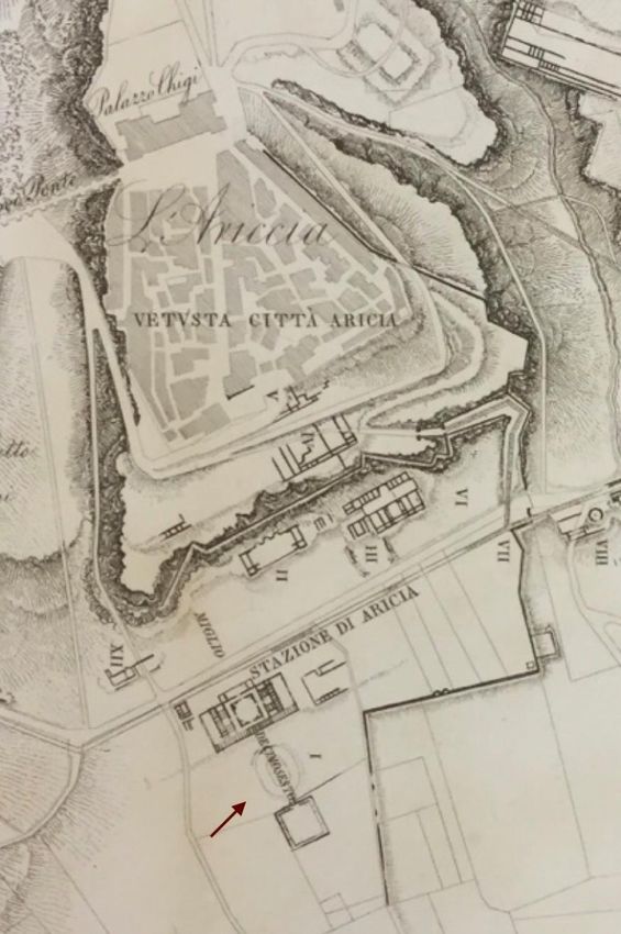
181G. Moretti Cursi, An update on an imperial building complex at the 16th mile of the Via Appia Fig. 3: Roma, Biblioteca di Archeologia e Storia dell’Arte (BiASA, fondo Lanciani, fol. 3), Archaeological Map of Ariccia; the arrow indicates the reconstruction of the amphitheatre. 182
Layers
8 (2023)
Fig. 4: Archaeological Map of Ariccia (FLORESCU 1925: fig. 1); the arrow indicates the
surviving structures of the amphitheatre at the time of Florescu.
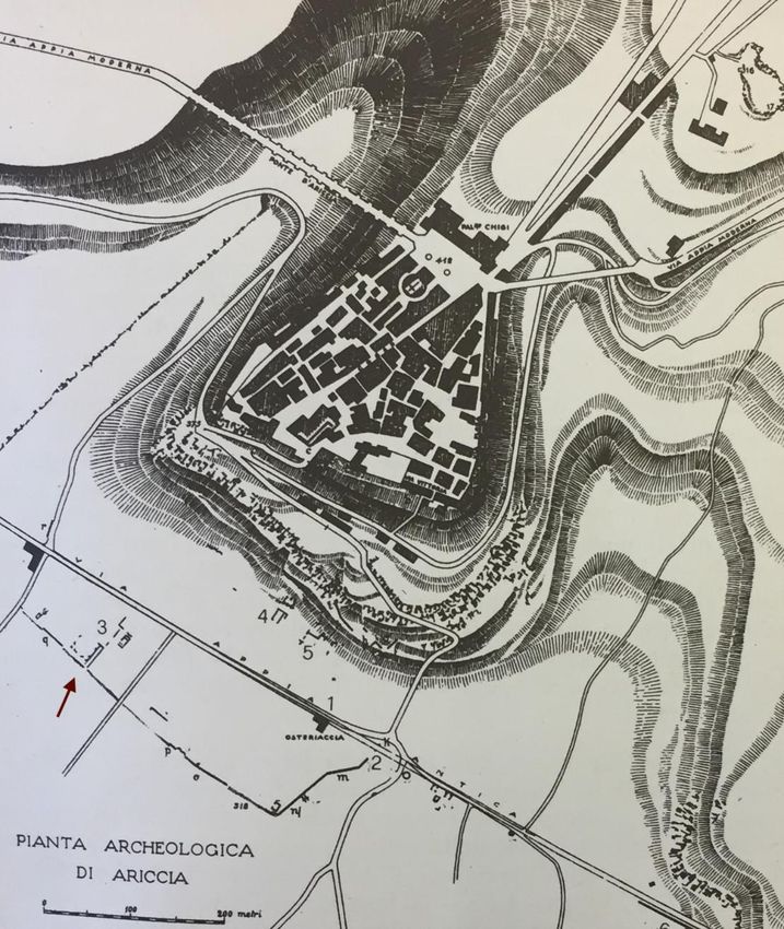
183G. Moretti Cursi, An update on an imperial building complex at the 16th mile of the Via Appia Fig. 5: Archaeological Map of Ariccia (LILLI 2001: fig. 26); the arrow indicates the point where Lucidi identifies the amphitheatre. 184
Layers
8 (2023)

Fig. 6: CAD reconstruction of the amphitheatre with the numerical data contained in
LUCIDI 1796: 214-215 (Moretti Cursi-Santarelli).

                                                                                185
You can also read