CONFRONTING THE WILDFIRE CRISIS - Expanding Efforts To Deliver on the Wildfire Crisis Strategy - USDA Forest Service
←
→
Page content transcription
If your browser does not render page correctly, please read the page content below
ForestService
                    Forest Service
                    U.S.DEPARTMENT
                    U.S. DEPARTMENTOF
                                   OFAGRICULTURE
                                      AGRICULTURE

FS-1187f | January 2023

                                                               WILDFIRE CRISIS
                                                                Landscape
                                                               Investments

CONFRONTING THE WILDFIRE CRISIS
Expanding Efforts To Deliver on the Wildfire Crisis Strategy
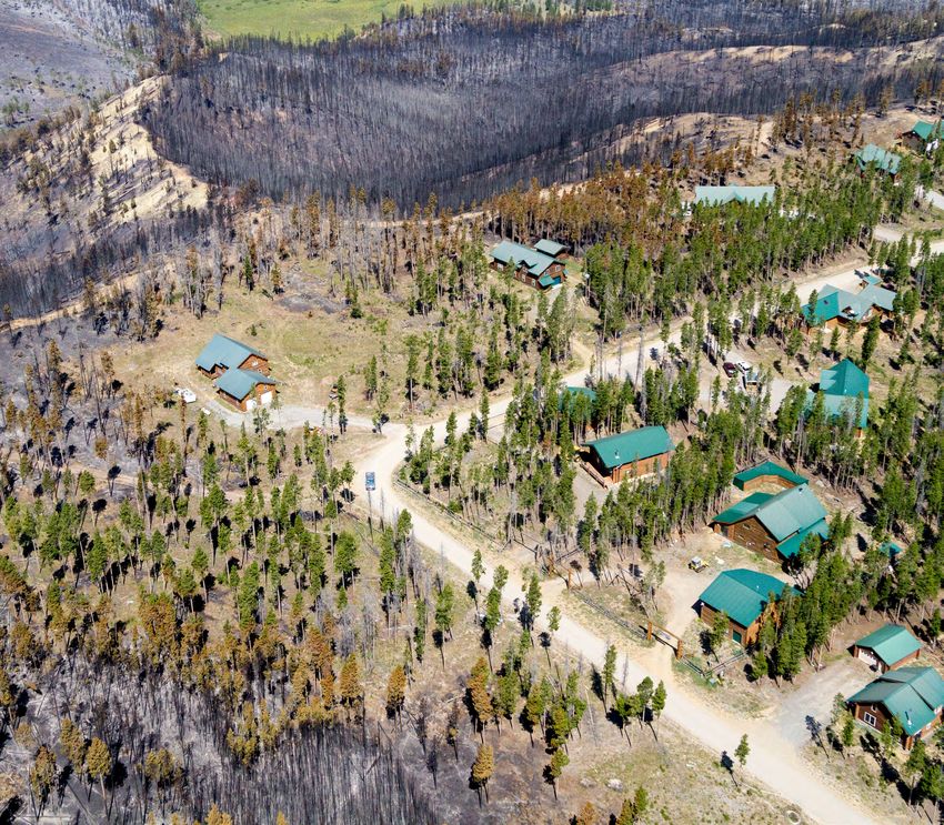
The Elko Front, located in northeastern Nevada,
encompasses about 20 rural communities,
including the city of Elko. The landscape
boundaries generally align with the Elko-Spring
Creek-Lamoille and South Ruby Mountains
Shared Stewardship high-priority landscapes.
The landscape and adjacent communities are at
high risk of catastrophic wildfire due to dense
fuels, declining forest health, noxious weed
infestations, persistent drought, and human-
caused ignitions. USDA Forest Service photo.
PROTECTING
COMMUNITIES
AND IMPROVING
RESILIENCE
At the U.S. Department of Agriculture Restoration Partnership (Joint Chiefs’), as the Wildfire Crisis Strategy, reducing risk The Secretary of Agriculture’s memorandum work with our partners and communities,
(USDA), Forest Service, we are entering well as the Bipartisan Infrastructure Law to communities, infrastructure, and critical on Climate Resilience and Carbon establishing mobile strike teams, and
our second year of carrying out our 10-
year strategy for confronting the wildfire
and Inflation Reduction Act. We are also
working closely with partners on activities
watersheds across the West. Stewardship of America’s National Forests
and Grasslands, released in June 2022,
using new technology that allows us to
plan and place treatments more effectively.
WHAT AREAS ARE
crisis in the West (Confronting the ranging from collaborative planning and
With additional funding under the
Inflation Reduction Act of 2022, we have
helped guide the selection process for We will also make our processes more HIGHEST PRIORITY
Wildfire Crisis: A Strategy for Protecting
Communities and Improving Resilience in
prioritization to capacity building, on-the-
ground improvements, and monitoring
selected 11 additional landscapes in 69
these 11 landscapes. The criteria included
not only wildfire exposure to buildings
efficient through a modernized grants and
agreements system, more effective National
FOR TREATMENT?
firesheds for treatment. We listened to High-risk firesheds are large
America’s Forests). success. in the wildland-urban interface but also Environmental Policy Act analyses, and
our employees, our partners, and Tribes forested landscapes and
exposure to underserved communities, expanded use of emergency authorities.
Our goal in launching the Wildfire Crisis Through the Bipartisan Infrastructure Law, on what mattered most to them, where rangelands where there is a high
Indigenous peoples and lands, sources of Because healthy forests depend on a healthy
Strategy was to safeguard communities Congress appropriated $1.4 billion to start opportunity exists, and where challenges likelihood that an ignition could
drinking water, habitats for native fish and forest products industry, we will expand
and the resources they depend on by putting our Wildfire Crisis Strategy into remain. Their feedback and our experience expose homes, communities,
wildlife, and more. We also considered our partnerships with mills, loggers, and and infrastructure to destructive
increasing fuels treatments over time, action with investments on 10 landscapes on these landscapes helped us identify
critical infrastructure and utility corridors. other industry stakeholders. By working wildfire. Firesheds, typically
promoting community readiness, in 8 Western States. Through work on both challenges to implementation and
Accordingly, the selected landscapes contain with all of our partners to pick up the pace about 250,000 acres in size, are
and supporting postfire recovery and these landscapes, as well as ongoing Joint conditions that can lead to future success.
multiple values at risk in project areas across and scale of our fuels and forest health mapped to match the scale of
restoration. To accomplish this, we are Chiefs’, CFLRP, and regularly appropriated We received more than 3,000 unique
26.7 million acres. treatments across the chosen landscapes, community exposure to wildfire.
using all funding sources, including hazardous fuels reduction projects, we ideas during interactive sessions and are
we will support local economies, protect
existing efforts like the Collaborative completed treatments on 3.2 million acres. considering them for implementation. In fiscal year (FY) 2023, we will increase
communities, and improve the health and
Forest Landscape Restoration Program We accomplished these treatments in 118 our capacity for fuels and forest health
resilience of forests.
(CFLRP) and Joint Chiefs’ Landscape of the 250 high-risk firesheds identified in treatments by incorporating new ways to
2 3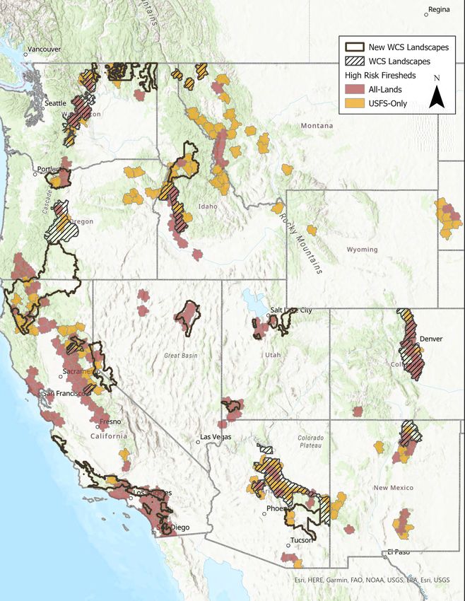
The Sierra Front is in western Nevada and
     eastern California, adjacent to the metropolitan
     areas of Reno-Sparks and Carson City. With
     a total population of more than 600,000, the
     area includes more than 10 rural communities
     along its western flank. The proposed landscape
     boundaries generally align with the Sierra
     Front-Carson-Walker Shared Stewardship high-
     priority landscape and are adjacent to high-risk
     firesheds in the neighboring Pacific Southwest
     Region. USDA Forest Service photo.

    THE WILDFIRE
    CRISIS
    Wildfires have been growing in size, duration, and
    destructivity over the past 30 years. The Nation has more
    than 460 million acres at moderate to very high risk from
    wildfire. Many western landscapes are at grave and growing
    risk from wildfire due to a combination of accumulating
    fuels, a warming climate, and expanding development in
    fire-prone landscapes. At the Forest Service, we are taking
    decisive action to confront this crisis.

          HOW DID WE GET HERE?
          WHERE ARE WE GOING?
          The wildfire crisis in the Western United
          States has been building for decades. A story
          map traces the origins of the crisis and what
          we are doing to confront it, giving a bird’s-
          eye view of the Wildfire Crisis Strategy and
          what it will achieve.
4                                                                 5
Fuels reduction work on the San Carlos Reservation and National            A firefighter works to maintain the
                                                     Forest System lands will reduce the exposure to wildfire of the Mount      perimeter boundary of a prescribed
                                                     Graham International Observatory and two telecommunications                fire. USDA Forest Service photo.
                                                     sites, which include primary communications systems for local law
                                                     enforcement. Work will also protect international waters shared with
                                                     the San Carlos Apache Tribe, associated drinking water systems, and
                                                     residential areas. USDA Forest Service photo.

                                                     OUR STRATEGY
                                                     FOR CONFRONTING
                                                     THE CRISIS
                                                     In January 2022, the Forest Service responded to the wildfire crisis
                                                     in the West by launching our Wildfire Crisis Strategy. Building on
                                                     the National Cohesive Wildland Fire Management Strategy and
                                                     our agreements with States and other partners under our Shared
                                                     Stewardship investment strategy, the Wildfire Crisis Strategy calls
                                                     for a new paradigm: stepping up the pace and scale of our fuels and
                                                     forest health treatments to match the actual scale of wildfire risk.

    WHAT TREATMENTS ARE                              We created a national team to work with Tribes and with Federal,
                                                     State, local, and private partners in crafting a 10-year Wildfire Crisis
    NEEDED TO REDUCE                                 Implementation Plan for the Wildfire Crisis Strategy. The plan—a
    FUELS AND RESTORE                                blueprint for executing the strategy through partnerships—is based

    FOREST HEALTH?                                   on peer-reviewed research and a framework for collaboration
                                                     established over the past 20 years. Under the plan, we are working
                                                     with our partners to focus our fuels and forest health treatments

                                                                                                                                   THE NEW ROUND OF INVESTMENTS
    Prescribed fire mimics nature’s fire when
    professionals apply wildland fire to             more strategically and at the scale of the problem, using the best
    fire-adapted landscapes under carefully          available science as our guide.
    prescribed conditions. Many low-elevation
                                                     Based on a fireshed analysis, our scientists have models for
    western forests originally had up to 60                                                                                         In August 2022, the President signed the Inflation Reduction        We have an emergency situation on National Forest System
                                                     identifying the firesheds most in need of fuels and forest health
    large trees per acre, but now each acre                                                                                         Act into law. The law made $5 billion in additional funding         lands within 250 high-risk firesheds across the West. In
    typically has hundreds of trees, mostly          treatments to reduce the risk of catastrophic wildfire. Scientific
                                                                                                                                    available to the Forest Service over 10 years, including $1.8       response, the Secretary of Agriculture is also authorizing
    small and highly flammable in a drought,         research guides the treatments needed to reduce the risk, including
                                                                                                                                    billion for fuels and vegetation treatments on the national         us to use a new emergency authority in the Bipartisan
    capable of sending flames into the canopy        mechanically thinning trees and conducting prescribed fires. We
                                                                                                                                    forests and grasslands in the wildland-urban interface. We will     Infrastructure Law, combined with strategic implementation
    for a devastating crown fire. The solution       estimate that up to 50 million acres of State, Tribal, Federal, private,
                                                                                                                                    use funding under the Inflation Reduction Act to invest in fuels    of existing authorities. Using the new authorities will enable us
    is to restore a semblance of the original        and other lands across the West are in need of treatment.
                                                                                                                                    and forest health treatment projects on 11 additional western       to accelerate planning, consultation, contracting, hiring, and
    fire-adapted landscape by (1) mechanically
                                                     In April 2022, in coordination with partners, we announced that                landscapes.                                                         implementation of fuels and forest health treatments across
    thinning trees to reduce the forest to
                                                     10 of the highest priority western landscapes would receive an                                                                                     the high-risk firesheds, including the 11 additional landscapes
    something approaching the historical                                                                                            We based our selection of the 11 landscapes on criteria set forth
    number of trees; (2) applying prescribed         initial investment of $131 million in FY 2022 under the Bipartisan                                                                                 and postfire recovery areas most impacted in the past several
                                                                                                                                    by the Secretary of Agriculture. In addition to wildfire exposure
    fire to further reduce hazardous fuels and       Infrastructure Law. The selected landscapes contain 68 high-risk                                                                                   years. Work will begin in coordination with partners and in full
                                                                                                                                    to buildings, our criteria included protecting underserved
    reintroduce fire effects into the fire-adapted   firesheds and about 13 million acres where we are applying the                                                                                     compliance with the National Environmental Policy Act and
                                                                                                                                    communities, critical infrastructure, public water sources, and
    system; and (3) at suitable intervals, using     funds to fuels and forest health treatment projects. The selected                                                                                  other applicable laws.
                                                                                                                                    proximity to Tribal lands. Listening to the more than 3,000
    both planned and unplanned ignitions to          landscapes overlap with National Forest System lands in the West
                                                                                                                                    comments from 11 roundtables held in the first half of 2022, we     The following pages include a map that shows the 11 landscapes
    re-create a fire-adapted landscape.              that require some level of immediate treatment.
                                                                                                                                    also chose landscapes with enough planning and resources in         selected for a new round of investments, as well as specific
                                                                                                                                    place to immediately begin work.                                    information for each landscape.

6                                                                                                                                                                                                                                                                           7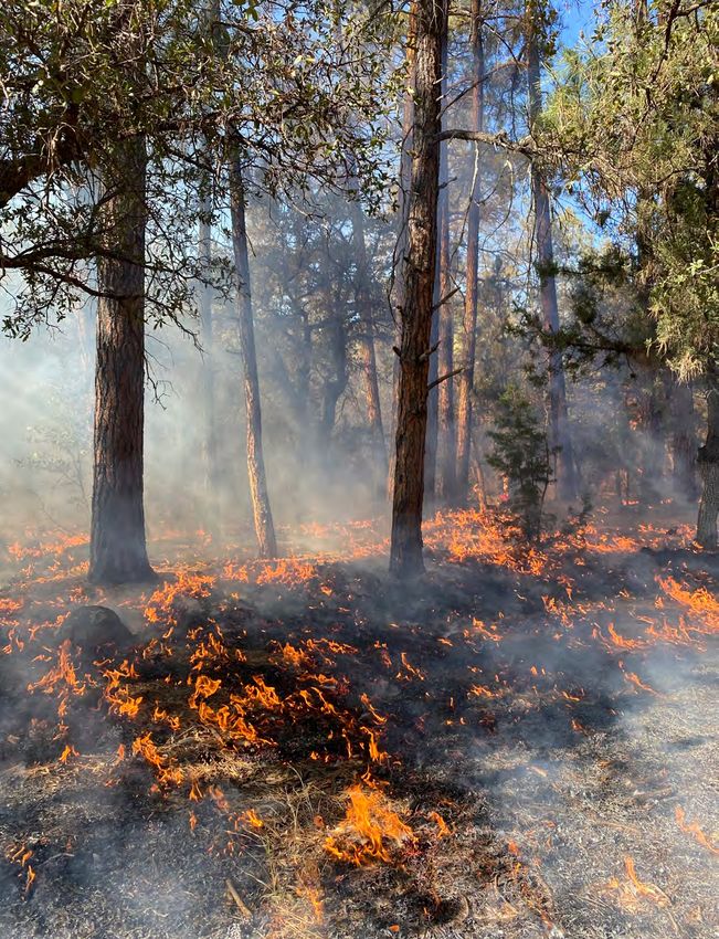
LANDSCAPE                                                                                                                                                    LANDSCAPES
    SELECTION                                                                                                                                                          NEW LANDSCAPES
    CONSIDERATIONS                                                                                          RISK TO COMMUNITIES:
                                                                                                                                                                       EXISTING LANDSCAPES

    SCALE: The wildfire crisis is not just on          risk, recovery, and resilience in communities                                                             HIGH-RISK FIRESHEDS
                                                                                                                   Areas with high structure density have
                                                       across the country. We will continue to use all                                                                  ALL LAND OWNERSHIPS
    National Forest System (NFS) lands. The crisis                                                                 relatively high wildfire risk to homes
                                                       authorities at our disposal.
    crosses the borders of Federal, State, Tribal,                                                          and communities. This area is known as the                  FOREST SERVICE LANDS
    and private lands, especially in the West. To      PARTNER INVESTMENTS:                                 wildland-urban interface, where buildings
    confront the crisis, we have to work across                  Achieving the desired pace and scale       and infrastructure meet or intermingle with
    boundaries and at a scale that can make the                  of treatments on these landscapes          undeveloped wildlands, and it is where
    greatest impact. For all 21 landscapes under       will require the support of State and local          wildfires have their greatest impacts on people.
    the Wildfire Crisis Strategy, we are already       governments, Tribes, nongovernmental                 We overlaid maps of structure density in the
    working with partners at a landscape scale         organizations, and industry. Many of the             wildland-urban interface with fireshed maps
    or have partnerships in place for working          landscapes already have momentum in using            to help locate high-priority areas for treatment.
    across landscapes. Together with our partners,     and sharing resources across boundaries.             Many high-priority landscapes identified for
    we must work at the scale needed to protect        We will work with existing and new partners          treatment are in firesheds with high exposure to
    communities while conserving ecological            to develop long-term funding plans for the           wildfire for the wildland-urban interface.
    values at risk from wildfire and drought.          landscapes.
                                                                                                            CRITICAL INFRASTRUCTURE:
    OUTCOMES: The projects on these                    EQUITY: Wildfires and other natural                         Critical infrastructure consists of
    landscapes focus on treating the right places at            disasters can pose significant threats to          powerlines and utility corridors.
    the scale needed to achieve desired outcomes:               a community’s health and well-being,        Wildfires in remote areas that threaten
    reduced wildfire risk to people, communities,      particularly for at-risk communities. At-risk        powerlines can adversely affect metropolitan
    infrastructure, water sources, and other values    communities may experience unique barriers           communities hundreds of miles away, so
    and resources. In making landscape selections,     in preparing for, responding to, and recovering      protecting powerlines from wildfires is critically
    we considered where investments could reduce       from wildfires. These communities may also           important. We compared maps of critical power
    exposure to wildfire, not just the number of       be more prone to health and environmental            supplies with fireshed maps to help locate high-
    acres that could be treated.                       impacts resulting from underlying social             priority areas for treatment.
                                                       and political conditions. How we consider,
    COLLABORATION: All landscapes                                                                           IMPORTANT ROADWAYS:
                                                       communicate with, outreach to, and support
    have projects that were collaboratively                                                                        Highways are important lifelines for
                                                       at-risk communities are critical components
    developed with communities and ready for                                                                       communities. Wildfires can impede
                                                       to successful implementation of the Wildfire
    implementation. Working together with                                                                   travel and commerce, with lasting effects due
                                                       Crisis Strategy. To help our land managers
    partners, we considered collaborative efforts                                                           to postfire mudflows and landslides across
                                                       and leaders determine needs and appropriate
    already in place and with opportunities to                                                              roadways. The cost of road repairs and long-
                                                       actions, we looked at various risk factors
    invest in underserved communities. These                                                                term commercial disruption can be high. We
                                                       at the county level to illustrate the social
    landscapes include other Federal, Tribal, State,                                                        overlaid maps of major roadways with fireshed
                                                       and demographic conditions within (and
    and private partner investments. Projects                                                               maps to help determine where the impacts of a
                                                       surrounding) each landscape. This analysis
    complement existing investments in fire-                                                                catastrophic wildfire would be greatest.
                                                       included U.S. Census data related to access to
    adapted communities.
                                                       services and support (e.g., persistent poverty,      MUNICIPAL WATER SUPPLIES:
    EXISTING AUTHORITIES:                              education status, unemployment status), health             For their drinking water, municipalities
    The landscapes align with States’ forest action    and mobility (e.g., age, disability), language             depend for their drinking water not only
    plans, building on past work and available         spoken, housing/egress (e.g., types of housing,      on runoff and ground water recharge from rain
    congressional authorities and programs,            access to transportation), and additional data       and snowmelt but also on impoundments and
    including the Collaborative Forest Landscape       related to community capacity (e.g., staffing,       other infrastructure, which are often located
    Restoration Program, Tribal Forest Protection      resources, expertise available to apply for          on National Forest System lands. We compared
    Act, Good Neighbor Authority, Joint Chiefs’        funding and build/manage projects over time).        maps of municipal watersheds and related
    Landscape Restoration Partnership, and Shared      This information will help shape relationships,      infrastructure with fireshed maps to determine
    Stewardship agreements. These investments add      communication, public education, and capacity        where the wildfire risk to municipal water
    to a broader portfolio of work through other       building for the Wildfire Crisis Strategy.           supplies was greatest.
    funding sources related to wildfire

8                                                                                                                                                                                        9
LANDSCAPES

                                SAN CARLOS APACHE TRIBAL
                                FOREST PROTECTION

     FOREST SERVICE REGION                       LANDSCAPE HIGHLIGHTS
     Southwestern                                This landscape includes National Forest System lands and San Carlos Reservation
                                                 lands. For cross-boundary landscape restoration, at the Forest Service, we will work
     NATIONAL FORESTS                            with the San Carlos Apache Tribe to build on the two Tribal Forest Protection Act
     Apache-Sitgreaves, Coronado, and Tonto      projects they initiated. Work on the landscape will protect international waters
     National Forests                            shared with the Tribe, associated drinking water systems, and residential areas.
                                                 Fuels reduction work will also reduce the exposure to wildfire of the Mount Graham
     STATE                                       International Observatory and two telecommunications sites, which include primary
     Arizona                                     communications systems for local law enforcement.

     LANDSCAPE SIZE                              MECHANISMS FOR EXECUTION
     3 million acres
                                                 Working cooperatively with the San Carlos Apache Tribe and various partners
                                                 (including the National Forest Foundation, the Arizona Game and Fish Department,
     TRIBAL CONNECTION
                                                 the Mule Deer Foundation, and the Salt River Project), we will use contracts and
     San Carlos Apache Tribe of the San Carlos
                                                 other partnership agreements during initial hiring and training and on-the-ground
     Reservation
                                                 fuels treatments and survey work.
     PARTNERS
     San Carlos Apache Tribe; National Forest    EXPECTED OUTCOMES
     Foundation; Arizona Game and Fish           Work on this landscape will reduce wildfire exposure to communities within the San
     Department; Mule Deer Foundation;           Carlos and Fort Apache Reservations. Landscape treatments will reintroduce wildland
     Arizona Department of Forestry and Fire     fire into fire-adapted ecosystems in a culturally sensitive way while emphasizing
     Management; Salt River Project              sustainable uses of cultural forest products, including clean water, traditional
                                                 medicinal plant cover, firewood, and culturally significant food sources such as
     CONGRESSIONAL DISTRICTS                     acorns, berries, and wildlife. Work will also foster public understanding and sharing
     AZ-1, AZ-2, and AZ-6                        of culturally significant information to better guide our land management decisions.

                                                 We expect to complete 87,000 acres of treatments between FYs 2023 and 2027.
     EXPECTED COMPLETION OF
                                                 However, during the first 2 years, the San Carlos Apache Tribe will be hiring, and
     INITIAL TREATMENTS
     Fiscal years 2023—27                        these new positions will add to the overall capacity to collaborate, develop, and
                                                 implement projects across the landscape. Once the capacity is established to develop
     EXPECTED FUNDING IN FY 2023                 and implement critically important treatments, we will work together to treat beyond
     $32,009,200                                 the initial 87,000 acres.

10                                                                                                                                       11
LANDSCAPES

                                     PLUMAS COMMUNITY PROTECTION

     FOREST SERVICE REGION                                             LANDSCAPE HIGHLIGHTS
     Pacific Southwest                                                 The Plumas Community Protection Projects Landscape focuses on community
                                                                       zones across the Plumas National Forest with very high, high, or moderate wildfire
     NATIONAL FOREST                                                   hazard potential. The landscape covers 284,912 acres in five high-risk firesheds.
     Plumas National Forest                                            Critical infrastructure includes hydroelectric power plants, drinking water, electrical
                                                                       transmission corridors, State highways, railroads, telecommunications, school
     STATE                                                             districts, and forest products industries. The Feather River provides electricity
     California
                                                                       and fresh water to over 27 million people and 4–5 million acres of farmland.
                                                                       Since catastrophic wildfires have burned 65 percent of the forest in recent years,
     LANDSCAPE SIZE
     285,000 acres                                                     protecting communities and infrastructure from future wildfires is essential.

     TRIBAL CONNECTIONS                                                MECHANISMS FOR EXECUTION
     Mechoopda Indian Tribe of Chico; Estom Yumeka Tribe               At the Plumas National Forest, we are focusing on contracts, agreements, and
     of Enterprise Rancheria; Mountain Maidu of Greenville             short-term internal Forest Service support to complete the Plumas Community
     Rancheria; Concow Maidu Tribe of Mooretown Rancheria;             Protection Projects. We are currently working with partners across the landscape
     Tyme Maidu Tribe of Berry Creek Rancheria; Susanville Indian      and have identified opportunities to expand partnerships and contracts, including
     Rancheria; Washoe Tribe of Nevada and California; Konkow
                                                                       an integrated resources service contract for project planning, implementation, and
     Valley Band of Maidu
                                                                       maintenance. We created an implementation team, including forest specialists and
                                                                       regional experts, to identify opportunities and threats so we can make a risk-based
     PARTNERS
                                                                       assessment of capacity to expand efforts. We are also working with other agencies
     Great Basin Institute; Lassen Fire Safe Council; Feather River
     Resource Conservation District, Sierra Nevada Conservancy;        through a long-term recovery working group established after the catastrophic
     Yuba Water Agency; Mule Deer Foundation; Butte County             Dixie Fire in 2021.
     Resource Conservation District; Plumas Corporation/Plumas
     County Fire Safe Council; Concow Maidu Tribe of Mooretown         ANTICIPATED OUTCOMES
     Rancheria; Konkow Valley Band of Maidu; the State of              Our work on the landscape will reduce exposure to wildfire for the 41 communities
     California; Butte, Lassen, Plumas, Sierra, and Yuba Counties;
                                                                       in 5 counties at highest risk within the Plumas National Forest, as well as the critical
     National Fish and Wildlife Foundation; National Forest
     Foundation; National Wild Turkey Federation; Trout Unlimited;     infrastructure and watersheds that serve them. We will improve road systems for
     Sierra Institute; Fire Safe Councils (Butte and Yuba); Firewise   community egress, reduce the potential for extreme fire behavior in the wildland-
     Communities in Plumas and Butte Counties; University of           urban interface, create a more resilient forest structure and ecological function, and
     California, Davis; California State University, Chico; Feather    foster an all-lands approach to fire and fuels management.
     River College; Maidu Consortium; Maidu Cultural Development
     Group; Tasmam Kovom Foundation; Ya-Mani Maidu Cultural            Our goals include treating 74,000 acres in FY 2023, with a total of 185,000 acres
     Association; and local industrial and public utility partners.    treated in following years, primarily in the wildland-urban interface.

     CONGRESSIONAL DISTRICTS
     CA- 1

     EXPECTED COMPLETION OF
     INITIAL TREATMENTS
     FYs 2023—26

     EXPECTED FUNDING, FY 2023
     $273,930,000

12                                                                                                                                                                13
LANDSCAPES
SOUTHERN CALIFORNIA FIRESHED
RISK REDUCTION STRATEGY
FOREST SERVICE REGION LANDSCAPE HIGHLIGHTS
Pacific Southwest The immense values at risk in southern California and the collaborative solutions
underway for vegetation management represent investment opportunities to avoid
NATIONAL FORESTS staggering social, economic, and ecological costs. Southern California’s national
Angeles, Cleveland, Los Padres, and San forests differ from many others across the Western United States. The dominant
Bernardino National Forests vegetation type, shrubland, has burned too frequently over the past century.
Because of this, the southern California landscape does not need the same types
STATE of treatments and maintenance as forested landscapes. This area has the Nation’s
California
highest concentration of high-risk firesheds and is home to 25 million people. There
is a large wildland-urban interface throughout the landscape, as well as Tribal lands,
LANDSCAPE SIZE
watersheds that provide municipal drinking water, and utility infrastructure.
4 million acres
MECHANISMS FOR EXECUTION
TRIBAL CONNECTIONS
Across the four national forests, we have flexible agreements and contracts with
Forty-four Tribes, Bands, and Nations with
members representing Acjachemen, ‘Atáaxum, the ability to expand work as funding allows, including contracts for mechanical
Cahuilla, Chemehuevi, Southern Paiute, treatments. By working with partners, we have more staff capacity for contract
Northern Chumash, Chumash, Cupeño, Diegeño, oversight and project implementation. We are also working with partners to boost
Esselen, Gabrieleno, Gabrielino, Iipay/Ipai, our joint capacity across the landscape. A new Tribal relations program manager will
Juaneño, Kitanemuk, Kizh, Kwaaymii, Kumeyaay, identify opportunities to work with the 44 Tribes and their associated communities
Kuupangaxwichem, Luiseño, Payómkawichum, throughout this landscape.
Qawishpa Cahuillangnah, Salinan, Serrano,
Tataviam/Fernandeño, Tipay/Tipai, Yokuts, and EXPECTED OUTCOMES
Tongva communities Through this additional investment, we will reduce wildfire exposure at the
landscape scale through ignition reduction, vegetation management, strategic fuel
PARTNERS breaks, and conservation of montane forest ecosystems. We will align vegetation
The State of California; National Forest management priorities with adjacent landowners. In the wildland-urban interface,
Foundation; Blue Forest Conservation;
we will work with partners to “harden” homes and utilities, create defensible space,
Conservation Investment Management; U.S.
and foster public education and responsible land use planning. Our work will also
Geological Survey; Climate Science Alliance; San
help major utility companies reduce ignition potential and their exposure to wildfire.
Diego State University; National Fish and Wildlife
Foundation; Pacific Gas and Electric; San Diego Our fuel break network and montane forest conservation will help to stop wildfires
Gas and Electric; Southern California Edison before they reach utilities, and our ignition reduction effort will prevent many
wildfires before they even begin. We will reduce wildfire risk to watersheds, along
CONGRESSIONAL DISTRICTS with the risk of postfire flooding and sedimentation.
CA-18–20, CA-23–31, CA-33, CA-39–41, and CA- Our goals include treating 5,000 acres in FY 2023, with a total of 27,500 acres in the
48–50
next 3 years.
EXPECTED COMPLETION OF
INITIAL TREATMENTS
FYs 2023—26
EXPECTED FUNDING, FY 2023
$10,000,000
14 15LANDSCAPES
TRINITY FOREST HEALTH AND
FIRE-RESILIENT RURAL COMMUNITIES
FOREST SERVICE REGION LANDSCAPE HIGHLIGHTS
Pacific Southwest The landscape centers on Trinity County and extends into neighboring Humboldt and
Shasta Counties. Trinity County has the highest wildfire risk in California and the
NATIONAL FORESTS State’s second highest wildfire risk to homes; other communities within or adjacent to
Shasta-Trinity and Six Rivers National Forests the landscape are also at high risk from wildfire. The landscape has 693,662 acres of
National Forest System lands (76 percent of the total), with the remainder in a mix of
STATE private and public ownerships.
California
Major roads include California State Routes 299, 36, and 3, which serve as
LANDSCAPE SIZE thoroughfares in an area without interstate highways. Route 299 is the largest
910,000 acres connection from the California interior to the Pacific Coast, with Route 36 as a
primary alternate route. Route 3 is the main north-south travel corridor through
TRIBAL CONNECTIONS Trinity and Siskiyou Counties, with no viable alternative in the landscape. Numerous
Hoopa Valley Tribe; Round Valley Indian Tribes, county and forest roads also serve as critical ingress/egress routes for local
Round Valley Reservation; Bear River Band communities.
of the Rohnerville Rancheria; Wiyot Tribe;
Redding Rancheria; Yurok Tribe of the Yurok MECHANISMS FOR EXECUTION
Reservation; Karuk Tribe On the Shasta-Trinity and Six Rivers National Forests, we have strong relationships
with Tribes and local partners and communities. Agreements with local partners
PARTNERS boost our capacity for fuels reduction, road maintenance and reconstruction, surveys
Watershed Research and Training Center;
(wildlife, botany, and archeology), field preparation of contracts, and third-party
Trinity County Resource Conservation District;
analysis under the National Environmental Policy Act. In addition, new tools such as
California Department of Forestry and Fire
the integrated resource service contract blanket purchase agreement and discussions
Prevention; Trinity County Collaborative Group
with Trinity County regarding a Good Neighbor Agreement will increase capacity.
CONGRESSIONAL DISTRICT
CA-1 and CA-2 ANTICIPATED OUTCOMES
Landscape work will protect local communities and critical infrastructure, including
EXPECTED COMPLETION OF natural gas pipelines, high-voltage transmission lines, the Trinity and Lewiston
INITIAL TREATMENTS Dams (hydroelectric power facilities that deliver water to the Central Valley Project),
FYs 2023—26 multiple radio and telecommunications sites on ridges and mountains, and multiple
community water sources, including Ruth Lake (the primary water source for about
EXPECTED FUNDING, FY 2023 88,000 Humboldt County residents).
$15,899,900
Our plan is to treat 6,855 acres in FY 2023, with a total of 65,000 acres treated in the
next 3 years.
16 17LANDSCAPES
NEZ PERCE-CLEARWATER-
LOWER SALMON
FOREST SERVICE REGION LANDSCAPE HIGHLIGHTS
Northern Region The Nez Perce-Clearwater National Forests are entirely within the ceded territory of the
Nez Perce Tribe. Adjacent to the Nez Perce Reservation and other rural communities,
NATIONAL FOREST the landscape continues to provide cultural and natural resources, including food, water,
Nez Perce-Clearwater National Forests timber, and recreation. The area includes watersheds of the Clearwater, Salmon, and
Snake Rivers, as well as Idaho County—the State’s largest county and 85-percent federally
owned. Forests in this landscape are critical for the local timber industry, which also
STATE depends on roads and other infrastructure at risk from wildfire.
Idaho
MECHANISMS FOR EXECUTION
LANDSCAPE SIZE Using successful Good Neighbor Agreements with the Nez Perce Tribe, Idaho
1.5 million acres Department of Lands, and Idaho Department of Fish and Game, at the Nez Perce-
Clearwater National Forests, we will reduce hazardous fuels and restore watersheds.
TRIBAL CONNECTIONS Future planning will include costewardship with the Nez Perce Tribe and cross-boundary
Nez Perce Tribe
collaboration with State and local partners to address climate change through aquatic
improvement projects, commercial timber harvest, prescribed fire, and mechanical
PARTNERS treatments across the landscape.
Idaho Department of Lands; Idaho
Department of Fish and Game; Idaho The Nez Perce-Clearwater landscape area has a robust timber industry to support
Department of Parks and Recreation; Idaho implementation of projects which require mechanical timber removal. Our timber
Governor’s Office of Species Conservation; program is diverse and efficient, using stewardship contracting, conventional sales, and
The Nature Conservancy; Trout Unlimited; Good Neighbor Agreements to maximize the capability to treat acres. Similarly, we have
Backcountry Hunters and Anglers; Idaho used contracts, agreements, and partners to implement prescribed fire and mechanical
Forest Group; Empire Lumber; Idaho
fuels treatments. We will also use these methods to improve roads, which will facilitate
Conservation League; Idaho County; American
landscape treatments.
Forest Resource Council; Hells Canyon
Recreation Collaborative; Clearwater Basin
EXPECTED OUTCOMES
Collaborative; North Central Idaho Resource
Work on this landscape will reduce fuels in and near high-risk firesheds, treat
Advisory Council; watershed advisory groups;
Idaho County Soil and Water Conservation acres identified in the “Idaho Forest Action Plan,” and restore watersheds critical to
District; county wildfire working groups; communities and habitat for threatened and endangered fish. This investment will aid
Rocky Mountain Elk Foundation future restoration of Musselshell Meadows, a culturally important area to the Nez Perce
Tribe. The investment will also expand the Nez Perce Tribe’s capability to costeward their
CONGRESSIONAL DISTRICTS ancestral homelands. Restoration treatments will contribute up to 250 million board feet
ID-1 to the timber industry over a 5- to 10-year period; treatments will also produce fuelwood
and biomass for commercial use. Road improvement will enhance access for exercising
EXPECTED COMPLETION OF Tribal treaty rights, recreation, and fire response while improving critical fisheries
INITIAL TREATMENTS habitats.
2028
Project goals include treating 5,000 acres in FY 2023 with a total of 55,000 acres treated
over 5 years, including 2,500 acres of stream and wetland restoration.
EXPECTED FUNDING, FY 2023
$34,000,000
18 19LANDSCAPES
MOUNT HOOD FOREST HEALTH AND
FIRE-RESILIENT COMMUNITIES
FOREST SERVICE REGION LANDSCAPE HIGHLIGHTS
Pacific Northwest This landscape in northwest Oregon comprises Federal, State, Tribal, and private
lands on and around the Mt. Hood National Forest (585,348 acres—54 percent of the
NATIONAL FOREST project area—are on national forest land). The project area includes three firesheds,
Mt. Hood National Forest several wilderness areas, and the Bull Run watershed, which furnishes drinking water
to nearly a million people in Portland and surrounding communities. More than a
STATE third of all Oregonians depend on water from this landscape.
Oregon
The landscape is highly urbanized, and the main economic drivers are natural
LANDSCAPE SIZE resources and tourism. Twelve communities with a total population of more than
1,081,355 acres 200,000 adjoin the landscape, which annually hosts nearly 3 million visitors.
Developed recreation includes four ski areas and a resort, along with extensive trails,
TRIBAL CONNECTIONS reservoirs, and campgrounds. The Bonneville Power Administration and Portland
Confederated Tribes of the Warm Springs General Electric have extensive utility corridors across the landscape.
Reservation; Confederated Tribes of the
Grand Ronde Community; Confederated MECHANISMS FOR EXECUTION
Tribes of the Siletz Indians Vegetation management and other fuels reduction work is guided by two strong
forest collaboratives with a range of industry and nongovernmental partners, along
PARTNERS with a newly formed fire mitigation partnership. At the Mt. Hood National Forest,
Oregon Department of Forestry; Oregon we work with the Oregon Department of Forestry using Good Neighbor Agreements
Department of Fish and Wildlife; Oregon
for fuels reduction projects and use a participation agreement through the Wyden
Department of Agriculture; Job Corps;
Amendment and the Omnibus Public Land Management Act of 2009 to fund
AmeriCorps; county and city governments;
treatments on lands managed by the Oregon Department of Fish and Wildlife. Using
local fire districts and community planning
organizations these and other agreements with State and local governments, community planning
organizations, local fire districts, Job Corps and other youth programs, and a newly
CONGRESSIONAL DISTRICTS established AmeriCorps partnership, we will carry out treatments on both National
OR-2, OR-3, and OR-5 Forest System and other lands. We will also use a contracting group for large-scale
noncommercial mechanical thinning, invasive weed removal, and other fuels
EXPECTED COMPLETION OF INITIAL reduction work.
TREATMENTS
2025 EXPECTED OUTCOMES
Our initial efforts will focus on treating firesheds on the east side of the Cascades. We
EXPECTED FUNDING, FY 2023 will work with counties and local organizations to expand our capacity to complete
$4,500,000 treatments on the westside. Our work will protect municipal water sources in the
Bull Run and The Dalles watersheds. We will coordinate all work on National Forest
System lands with work on adjacent lands in other ownerships.
Our goals include treating 4,400 acres in 2023 and 8,000 acres in 2024.
20 21LANDSCAPES
KLAMATH RIVER BASIN
FOREST SERVICE REGIONS LANDSCAPE HIGHLIGHTS
Pacific Southwest and Pacific Northwest At the Forest Service, we manage about 55 percent of the 10-million-acre Klamath
Basin. These lands generate 80 percent of the mean annual surface water supply
NATIONAL FORESTS to the Klamath River. The area provides important habitat for fish listed under the
Modoc, Klamath, Six Rivers, Shasta-Trinity,
Endangered Species Act. Fish like steelhead, salmon, and suckers are vital to the
and Fremont-Winema National Forests
culture and well-being of Tribes in the Klamath Basin. Following the planned removal
of four dams on the Klamath River, National Forest System lands will provide habitat
STATES
for fish that have been excluded from the upper basin.
California and Oregon
For several decades, Federal, State, and other partners have warned that the Klamath
LANDSCAPE SIZE Basin is in critical need of restoration. Catastrophic wildfires have damaged or
10 million acres degraded ecosystems and communities across five national forests in the Klamath
Basin, a trend that is likely to continue as the climate becomes hotter and drier. The
TRIBAL CONNECTIONS effects of a changing climate on hydrology and wildfire activity are degrading fish
Klamath Tribes; Karuk Tribe; Yurok Tribe; habitat, including contributing to habitat loss through postfire landslides. Many
Hoopa Valley Tribe; Quartz Valley Indian affected communities are in rural counties with some of the lowest median incomes
Reservation; Resighini Rancheria; Pit River
in their respective States.
Tribe; Shasta Indian Nation; Modoc Nation
MECHANISMS FOR EXECUTION
PARTNERS
We will invest in projects in collaboration with Tribes and other partners. We will
U.S. Fish and Wildlife Service; National
explore opportunities for new agreements to work with our Tribal, Federal, State, and
Park Service; USDA Natural Resources
Conservation Service; National Marine other partners. We will also use innovative stewardship contracts, such as the Blue
Fisheries Service; Oregon Department of Mile G-Z Stewardship integrated resource service contract on the Fremont-Winema
Forestry; California Department of Forestry National Forest.
and Fire Protection; California Climate
Investment Program; Western Klamath EXPECTED OUTCOMES
Restoration Partnership; Mid-Klamath In addition to reduced wildfire exposure and risk for communities within the
Watershed Council; Klamath Lake Forest Klamath Basin, we will improve watershed conditions and salmonid habitats in the
Health Partnership; community of Chiloquin; face of climate change. These improvements will support underserved communities
National Wild Turkey Federation and local economies.
CONGRESSIONAL DISTRICTS We will treat up to 52,080 acres in FY 2023: 37,510 in California and 14,570 in
CA-1 and CA-2; OR-2 Oregon. At least 217,000 acres will be treated through FYs 2023–31. In addition to
investments identified with announcing this landscape, our goal is to attract another
EXPECTED COMPLETION OF INITIAL $15 million in partner contributions.
TREATMENTS
FYs 2023—31
EXPECTED FUNDING, FY 2023
$35,400,000
22 23LANDSCAPES
SIERRA AND ELKO FRONTS
FOREST SERVICE REGION LANDSCAPE HIGHLIGHTS
Intermountain The Sierra and Elko Fronts landscape includes the Sierra Front (about 2 million acres)
and the Elko Front (about 1.4 million acres). National Forest System lands make up
NATIONAL FOREST about 810,000 acres on the Sierra Front and 340,000 acres on the Elko Front, for a
Humboldt-Toiyabe National Forest total of about 1.15 million acres (34 percent) across the entire landscape. Private/
other lands account for about 1.4 million acres (41 percent) of the entire project area,
STATES public lands managed by the Bureau of Land Management comprise 720,000 acres (21
Nevada and California percent), State lands make up 56,000 acres (2 percent), and Tribal lands account for
35,000 acres (1 percent).
LANDSCAPE SIZE
3.4 million acres The Sierra Front is in western Nevada and eastern California, adjacent to the
metropolitan areas of Reno-Sparks and Carson City. With a total population of more
TRIBAL CONNECTIONS than 600,000, the area includes more than 10 rural communities along its western
Bridgeport Indian Colony; South Fork Band flank. The proposed landscape boundaries generally align with the Sierra Front-
of the Te-Moak Tribe of Western Shoshone Carson-Walker Shared Stewardship high-priority landscape and are adjacent to high-
Indians of Nevada; Washoe Tribe of Nevada risk firesheds in the neighboring Pacific Southwest Region.
and California; Reno-Sparks Indian Colony;
Mooretown Rancheria of Maidu Indians of The Elko Front, located in northeastern Nevada, encompasses about 20 rural
California communities, including the city of Elko. The landscape boundaries generally align
with the Elko-Spring Creek-Lamoille and South Ruby Mountains Shared Stewardship
PARTNERS high-priority landscapes. The landscape and adjacent communities are at high risk
Nevada Shared Stewardship Priority of catastrophic wildfire due to dense fuels, declining forest health, noxious weed
Landscape Planning Groups; Nevada Division infestations, persistent drought, and human-caused ignitions.
of Forestry; State of Nevada; NV Energy
MECHANISMS FOR EXECUTION
CONGRESSIONAL DISTRICTS At the Humboldt-Toiyabe National Forest, we will use existing agreements (with
NV-2 and NV-4; CA-3 State, Federal, nongovernmental, and private partners) and regional office contracts,
together with our 5-year vegetation and fuels plan, to step up the pace and scale of
EXPECTED COMPLETION OF treatments and to chart a roadmap for annual implementation, planning, and funding
INITIAL TREATMENTS needs. We will also develop any additional agreements and contracts needed to
FYs 2023–26 complete the work.
EXPECTED FUNDING IN FY 2023 ANTICIPATED OUTCOMES
$57,375,000
Our goal for this landscape is to reduce the exposure of people, communities,
and natural resources to wildfire while sustaining and restoring healthy, resilient,
fire-adapted forests. Working with our partners, we will reduce the exposure to
wildfire for large cities, Tribal lands, rural communities, and watersheds. We will
protect infrastructure, including utility, energy, and mining facilities; transportation
corridors, such as Federal, State, and county highways and railroads; the Marine
Corps Mountain Warfare Training Center; and recreation areas. Our work will
also improve natural resources, including habitat for mule deer, sage grouse, and
threatened Lahontan cutthroat trout.
Landscape goals include treating 22,000 acres in FY 2023; 15,000 acres in FY 2024;
24 and 208,000 acres over 7 to 10 years. 25LANDSCAPES
PINE VALLEY
FOREST SERVICE REGION LANDSCAPE HIGHLIGHTS
Intermountain The Pine Valley landscape is adjacent to St. George, UT, America’s fastest growing
metropolitan area. The landscape encompasses about 250,000 acres of National Forest
NATIONAL FOREST System lands (63 percent of the total project area) and 150,000 acres (37 percent) of
Dixie National Forest lands in private ownership or under stewardship by the State of Utah or the Bureau of
Land Management. The landscape’s low elevation and topography make it particularly
STATE susceptible to climate change and shifting fire patterns, creating an urgent need to
Utah reduce the risk of catastrophic wildfire.
LANDSCAPE SIZE MECHANISMS FOR EXECUTION
402,000 acres On the Dixie National Forest, we have well-established working relationships with
Federal, State, local, and nongovernmental partners on projects to reduce wildfire risk
TRIBAL CONNECTIONS across jurisdictional boundaries on the Pine Valley landscape. For the past 10 years,
Havasupai Tribe of the Havasupai
we have collaborated with Utah’s Watershed Restoration Initiative, which involves
Reservation; Hualapai Indian Tribe of the
dozens of partners, in conducting vegetation treatments to reduce the exposure of
Hualapai Indian Reservation; Hopi Tribe of
Arizona; Navajo Nation; Ute Indian Tribe of infrastructure and natural resources to uncharacteristic wildfire. We have also carried
the Uintah & Ouray Reservation; Paiute Indian out Shared Stewardship fuels projects in watersheds across the Pine Valley landscape
Tribe of Utah (Cedar Band of Paiutes, Shivwits and used Good Neighbor Authority for the past 15 years to complete key treatments.
Band of Paiutes); Las Vegas Tribes of Paiute Through strong and lasting partnerships, we will use this investment to reduce
Indians of the Las Vegas Indian Colony; San wildfire exposure across the Pine Valley landscape.
Juan Southern Paiute Tribe of Arizona; Kaibab
Band of Paiute Indians of the Kaibab Indian ANTICIPATED OUTCOMES
Reservation; Moapa Band of Paiute Indians Our work with our partners on this landscape will reduce wildfire risk to St. George
and adjacent communities, many in the wildland-urban interface. We will reduce
PARTNERS wildfire risk to infrastructure, including national travel corridors and energy
Utah Division of Forestry, Fire and State networks. We will protect watersheds and water quality. A major goal is to reduce
Lands; Utah Division of Wildlife Resources; risks to communities both during and after wildfires by restoring and maintaining
Utah’s Watershed Restoration Initiative;
healthy, fire-adapted landscapes.
Washington County; Iron County; Bureau of
Land Management; USDA Natural Resources Our goals also include treating 6,554 acres in FY 2023 and at least 43,500 acres over 7
Conservation Service; utility companies to 10 years.
CONGRESSIONAL DISTRICT
UT-2
EXPECTED COMPLETION OF
INITIAL TREATMENTS
FYs 2023—26
EXPECTED FUNDING FY 2023
$6,915,000
26 27LANDSCAPES
WASATCH
FOREST SERVICE REGION LANDSCAPE HIGHLIGHTS
Intermountain The Wasatch landscape encompasses approximately 1.1 million acres, including
National Forest System, State, private, and Bureau of Land Management lands. Fire
NATIONAL FOREST hazard on about 382,000 acres of the Wasatch landscape is classified as high or very
Uinta-Wasatch-Cache National Forest high, threatening watersheds, plant and wildlife habitats, recreational opportunities,
and private property. The landscape encompasses four high-risk firesheds, as well as
STATE high-priority landscapes under Utah’s Shared Stewardship agreement.
Utah
Northern Utah has some of the Nation’s fastest growing areas in the wildland-urban
LANDSCAPE SIZE interface, with an increasing number of communities at risk of wildfire, 92 of which
1.1 million acres are within or adjacent to the landscape. Watersheds in the landscape furnish drinking
water to more than 2 million people; these watersheds are highly sensitive to projected
TRIBAL CONNECTIONS increases in drought, heat, and flooding, as well as the effects of wildfires, insect and
Confederated Tribes of the Goshute disease outbreaks, and land use change. The landscape has more than 300 miles of
Reservation; Skull Valley Band of Goshute regionally important energy infrastructure supporting the growing population of
Indians of Utah; Northwestern Band of northern Utah. Recreational values and infrastructure in the area support more than 13
the Shoshone Nation; Ute Indian Tribe of million visitors a year, including a $1.4-billion ski industry with seven resorts (five on
the Uintah & Ouray Reservation; Eastern national forest lands).
Shoshone Tribe of the Wind River Reservation;
Shoshone-Bannock Tribes of the Fort Hall
MECHANISMS FOR EXECUTION
Reservation
At the Uinta-Wasatch-Cache National Forest, we have a well-established framework
for responding to the wildfire crisis across jurisdictional boundaries on the Wasatch
PARTNERS
landscape, including a history of collaboration with Federal, State, and local partners
Utah’s Watershed Restoration Initiative,
including dozens of partners who contribute and nongovernmental organizations. For the past 10 years, we have collaborated
funding for fuels and forest health extensively with Utah’s Watershed Restoration Initiative to plan and carry out
treatments to reduce wildfire risk; the vegetation treatments that reduce the risk of catastrophic wildfire.
fuels focus group for the central Wasatch
Front, which includes the State of Utah, Salt EXPECTED OUTCOMES
Lake City Public Utilities, Salt Lake County, We will reduce exposure to wildfire of private property and infrastructure in the
and Save Our Canyons; and the Summit wildland-urban interface through cross-boundary mechanical treatments. We
and Wasatch County Collaborative Fuels will increase opportunities to use prescribed fire and wildland fire to support the
Reduction Group suppression of wildfires by creating or strengthening strategic fuel breaks. This work
will protect watersheds and restore forest health and resilience.
CONGRESSIONAL DISTRICTS
UT-1–4 Our goal is to treat 14,200 acres in FY 2023 and at least 105,000 acres over 7 to 10 years.
EXPECTED COMPLETION OF
INITIAL TREATMENTS
Fiscal years 2023—26
EXPECTED FUNDING IN FY 2023
$18,250,000
28 29LANDSCAPES
COLVILLE NORTHEAST
WASHINGTON VISION
FOREST SERVICE REGION LANDSCAPE HIGHLIGHTS
Pacific Northwest Adjacent to the Colville Reservation in northeastern Washington, communities
within this landscape include Tonasket, Republic, Colville, Chewelah, Metaline Falls,
NATIONAL FOREST Ione, and Newport. Critical infrastructure in the landscape includes State Routes 395
Colville National Forest and 20 and large energy facilities, including biomass and hydropower. In addition,
the landscape has vital habitat for species listed or proposed for listing under the
STATE Endangered Species Act, including Canada lynx, grizzly bear, whitebark pine,
Washington woodland caribou, and bull trout.
LANDSCAPE SIZE MECHANISMS FOR EXECUTION
1.6 million acres
On the Colville National Forest, we rely heavily on the health of the local wood
products industry and will use stewardship contracts and partnership agreements
TRIBAL CONNECTIONS
to complete project work. The local wood products industry can support fuels
Confederated Tribes of the Colville
treatments and stewardship contracts by processing biomass, small-diameter logs,
Reservation; Kalispel Tribe of Indians;
Spokane Tribe of Indians and larger materials. This industry can also help generate the revenues needed to pay
for followup noncommercial work, allowing us to achieve goals for fuels reduction
PARTNERS and forest health. In addition to local industry, other partners such as Tribal, State,
Kalispel Tribe of Indians; Confederated Tribes and local governments will help us execute contracts, augment our workforce, and
of the Colville Reservation; Washington State maintain healthy forests at the landscape scale.
Department of Natural Resources; Avista
Power; Bonneville Power Administration; EXPECTED OUTCOMES
Seattle City Light Building on relationships with Tribal Governments, the Washington State
Department of Natural Resources, timber industry partners, and collaborative
CONGRESSIONAL DISTRICTS groups, our work will focus on improving the resilience of fire-adapted landscapes.
WA-4 and WA-5 We will also reduce fuels to limit wildfire impacts and the risk of catastrophic wildfire
and improve prospects for postfire recovery. Our current fuels treatment projects
EXPECTED COMPLETION OF will be expanded to broaden the scale of active forest management. The local wood
INITIAL TREATMENTS products industry—already an integral partner—will become larger and more
2032 versatile. Communities and critical infrastructure will be better protected and receive
better support for postfire recovery.
EXPECTED FUNDING, FY 2023
$2,160,000 Our goals include treating 2,000 acres per year, with a total of 20,000 acres over the
next 10 years.
30 31The Wasatch landscape encompasses
approximately 1.1 million acres, including
National Forest System, State, private, and
Bureau of Land Management lands. Fire
hazard on about 382,000 acres of the Wasatch
WHAT’S NEXT
landscape is classified as high or very high,
threatening watersheds, plant and wildlife
habitats, recreational opportunities, and
private property. USDA Forest Service photo.
This new round of 11 landscapes, made possible through funding under
the Inflation Reduction Act, gives us at the Forest Service and our partners
fresh opportunities to reduce wildfire risk across high-risk firesheds and
restore fire-adapted western forests to health and resilience. Nevertheless,
we still face major challenges, including barriers to Federal hiring,
nationwide labor shortages, rising housing costs, and lack of available
housing, especially in rural areas where the work is needed most. We also
remain well short of the resources needed to complete all of the work
called for in the Wildfire Crisis Strategy.
With our partners, we will continue to seek solutions to the challenges
we face, partly by finding new ways of working together. Working with
partners, we are building public support for the needed work, moving
efficiently through environmental review, and coping with the complexity
of prescribed fire in the wildland-urban interface. Across the West, we are
also exploring creative ways of increasing our workforce capacity, such as
using specialized teams on key landscapes and improving the way we track
our treatments and the benefits that people get from them. In the longer
term, we will need additional support from both Congress and outside
stakeholders to fully implement the Wildfire Crisis Strategy.
The wildfire crisis in the West is a national emergency. On these additional
11 landscapes, we will rise to the challenge by placing the right treatments
at the scale needed to match the scale of wildfire risk. We are working in
a way that meets the urgency of the moment, and we invite our partners
and the people we serve to help us shift to this new paradigm for land
management. We need a large multijurisdictional coalition of partners and
stakeholders to help us carry out our Wildfire Crisis Strategy and reduce
wildfire risk across fire-adapted western landscapes. Our work would
not be possible without our partners, and we will continue to embrace
partnerships as the key to our collective success.
MAKING A DIFFERENCE
Given the scale of the wildfire crisis, fully achieving our
goals under the Wildfire Crisis Strategy will take time,
but we have already begun ramping up our fuels and
forest health treatments. A progress summary outlines
initial projects across 10 of the highest priority western
landscapes and some of our first accomplishments.
32 33KEY SCIENCE
Ager, A.A.; Day, M.A.; Palaiologou, P. [and others]. 2019. Cross-boundary wildfire and community
exposure: a framework and application in the Western U.S. Gen. Tech. Rep. RMRS-GTR-392. Fort
Collins, CO: USDA Forest Service, Rocky Mountain Research Station. 36 p.
Ager, A.A.; Evers, C.R.; Day, M.A. [and others]. 2021. Planning for future fire: scenario analysis of
an accelerated fuel reduction plan for the Western United States. Landscape and Urban Planning.
215. November: 104212.
Ager, A.A.; Day, M.A.; Ringo, C. [and others]. 2021. Development and application of the Fireshed
Registry. Gen. Tech. Rep. RMRS–GTR–425. Fort Collins, CO: USDA Forest Service, Rocky
Mountain Research Station. 47 p.
Martinuzzi, S.; Stewart, S.I.; Helmers, D.P. [and others]. 2015. The 2010 wildland-urban interface
of the conterminous United States. Res. Map NRS-8. Newtown Square, PA: USDA Forest Service,
Northern Research Station. 124 p.
In accordance with Federal civil rights law and U.S. Department of Agriculture (USDA) civil rights regulations
and policies, the USDA, its Agencies, offices, and employees, and institutions participating in or administering
USDA programs are prohibited from discriminating based on race, color, national origin, religion, sex, gender
identity (including gender expression), sexual orientation, disability, age, marital status, family/parental status,
income derived from a public assistance program, political beliefs, or reprisal or retaliation for prior civil rights
activity, in any program or activity conducted or funded by USDA (not all bases apply to all programs). Remedies
and complaint filing deadlines vary by program or incident.
Persons with disabilities who require alternative means of communication for program information (e.g., Braille,
large print, audiotape, American Sign Language, etc.) should contact the responsible Agency or USDA’s TARGET
Center at (202) 720-2600 (voice and TTY) or contact USDA through the Federal Relay Service at (800) 877-8339.
Additionally, program information may be made available in languages other than English.
To file a program discrimination complaint, complete the USDA Program Discrimination Complaint Form, AD-
3027, found online at How to File a Program Discrimination Complaint and at any USDA office or write a letter
addressed to USDA and provide in the letter all of the information requested in the form. To request a copy of the
complaint form, call (866) 632-9992. Submit your completed form or letter to USDA by: (1) mail: U.S. Department
of Agriculture, Office of the Assistant Secretary for Civil Rights, 1400 Independence Avenue, SW, Washington,
D.C. 20250-9410; (2) fax: (202) 690-7442; or (3) email: program.intake@usda.gov.
USDA is an equal opportunity provider, employer, and lender.
Cover Photo: Lava Mountain Fire, Shoshone National Forest, WY. USDA Forest Service photo by Kristen Honig.
34 35You can also read