FLOOD GUIDANCE STATEMENT USER GUIDE - JANUARY 2020 - Flood Forecasting Centre
←
→
Page content transcription
If your browser does not render page correctly, please read the page content below
A working partnership between

  FLOOD
  GUIDANCE
  STATEMENT
  USER GUIDE
   JANUARY 2020

FLOOD FORECASTING CENTRE

INTRODUCTION
THIS USER GUIDE HAS BEEN      It replaces the previous version (dated
PRODUCED BY THE FLOOD         January 2017) in full, and now includes
                              relevant parts of the ‘Talking the Same
FORECASTING CENTRE (FFC)      Language’ forecasting glossary that was
FOR USE BY THE UK AND         available separately. We have combined
                              and simplified these documents to make
WELSH GOVERNMENTS AND ALL     this a ‘one stop shop’ for information on

CATEGORY 1 & 2 RESPONDERS     using flood forecasts.

ACROSS ENGL AND AND WALES     We welcome your feedback. Please contact
                              us by telephone: 0300 12345 01 or email:
FOR WINTER 2017/18 ONWARDS.   ffcenquiries@environment-agency.gov.uk
FLOOD GUIDANCE STATEMENT USER GUIDE — ISSUED JANUARY 2020                                                                                02–03

OVERVIEW

THE FLOOD GUIDANCE
STATEMENT (FGS) PROVIDES A
DAILY FLOOD RISK FORECAST
FOR THE UK AND WELSH
GOVERNMENTS AND CATEGORY
1 & 2 EMERGENCY RESPONDERS
TO ASSIST WITH STRATEGIC,
TACTICAL AND OPERATIONAL
PL ANNING DECISIONS.

T
        his assessment of flood risk is shown    The FGS is issued by the FFC every day at       than in isolation. We separately produce a
        by county and unitary authority          10:30am and at other times, day or night, if    public flood risk forecast which is available
        across England and Wales over            the flood risk assessment changes. It is made   from the Environment Agency and Natural
five days. It is based on a reasonable worst     available on the Met Office Hazard Manager      Resources Wales websites and these
case scenario which identifies situations that   and Cabinet Office Resilience Direct systems    services should be promoted to customers
could cause flooding, threaten communities       after publication.                              outside the emergency response community.
and pose a risk to lives and livelihoods.
The FGS covers all types of natural flooding     The FGS is supported by National and Local      The FFC operates a 365 day 24/7 service
– coastal/tidal, river, groundwater and          Flood Advisory Services. These advisory         and you can speak to us directly on 0300
surface water.                                   services are run as telephone conferences       1234501 to discuss the FGS. You can also
                                                 to initiate early discussion of flood risk.     contact your local Environment Agency or
It is produced by the FFC and local              They help to ensure emergency responders        Natural Resources Wales flood teams or
Environment Agency and Natural                   receive consistent and timely information       Met Office Advisor (civil contingencies)
Resources Wales flood forecasting teams,         from the Met Office, FFC, Environment           for information about the local situation.
joining up national and local information.       Agency and Natural Resources Wales.
The FGS presents the best combined               The FGS is specifically produced and
understanding of overall flood risk based        circulated only to registered Category 1 and
on weatherforecasts, flood forecasts,            2 emergency responders, and organisations
catchment conditions and the operational         involved in flood response. It should be used
status of flood defences and assets.             together with the Advisory Services, rather
FLOOD FORECASTING CENTRE

HOW TO RECEIVE
AND VIEW THE FGS

THE FGS IS DISTRIBUTED VIA   You can select which counties or unitary authorities
                             you are interested in, and whether you wish to
EMAIL AS A PDF DOCUMENT      receive the FGS at different flood risk levels. We’d
                             advise receiving the FGS at all flood risk levels so
AND YOU CAN REGISTER TO      you receive all the information available in the lead
RECEIVE IT HERE.             up to any floods.

                             We encourage individuals to register rather than
                             use generic accounts so we can maintain contact
                             details, circulate service messages, user guide
                             updates and customer surveys.

                             You can register for the Hazard Manager system
                             to view the FGS online, together with a range of
                             weather information here. The system offers you
                             the ability to view and filter by flood source and
                             flood impact level.

                             The FGS is available on Resilience Direct Maps
                             which uses the FGS open data. Users can create
                             a map and add the FGS Area of Concern layer.
                             The ‘Feature Info’ section provides a link to the
                             full FGS document.

                             We have also made the data for the FGS available
                             as open data here for England and here for Wales.
FLOOD GUIDANCE STATEMENT USER GUIDE — ISSUED JANUARY 2020                                                               04–05

  FLOOD RISK
  ASSESSMENT
  AND MATRIX

 TO ASSESS THE LEVEL OF                                                        Assessments are made in different ways for
                                                                               coastal/tidal, river, surface water and ground-
 RISK WE TAKE INTO ACCOUNT                                                     water. These are then presented on a coloured,
                                                                               4x4 risk matrix depending on the forecast
 A L ARGE NUMBER OF WEATHER,                                                   impact and likelihood.
 CATCHMENT AND COASTAL
                                                                               The flood risk matrix shows the assessment of
 FACTORS AND INFORMATION                                                       impacts against likelihood for counties and unitary

 ON THE POTENTIAL IMPACT                                                       authorities in England and Wales for the five day
                                                                               period, for all sources of flooding.
 OF THESE FACTORS ON LOCAL
 COMMUNITIES.

                High
Likelihood

             Medium

                 Low

             Very Low

                        Minimal       Minor             Significant   Severe

                                                   Impact

                        Very Low      Low               Medium        High

                                              Overall Flood Risk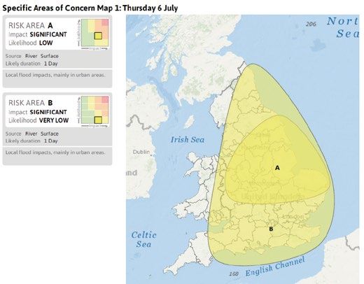
FLOOD FORECASTING CENTRE

FLOOD RISK
MATRIX GUIDANCE
ON IMPACTS
                      This table shows typical examples of impacts
                      from flooding and aligns with the four columns
                      in the Flood Risk Matrix. Detailed local impacts
                      are shared at Flood Advisory Service telephone
                      conferences.
FLOOD IMPACTS TABLE

                                      Minimal Impacts                 Minor Impacts                  Significant Impacts             Severe Impacts

                                      Not expected                    Individual risk for the more   Danger to life from fast        Danger to life from fast
                       Risk to Life

                                                                      vulnerable or for those        flowing / deep water /          flowing / deep water /
                                                                      making decisions in            wave overtopping / wave         wave overtopping /wave
                                                                      unfamiliar situations          inundation and physical         inundation and physical,
                                                                      (e.g. when crossing fords      hazards (e.g. getting stuck     chemical or utility hazards
                                                                      or rescuing pets)              in water)                       (e.g. electrocution)

                                      Isolated and localised          Localised flooding of land     Some communities                Communities cut off
                                      flooding of low-lying land      and roads                      temporarily inaccessible
                                      and roads                                                      due to flooded access
                                                                                                     routes
                       Communities

                                      Isolated instances of spray/    Localised flooding             Flooding affecting              Widespread flooding
                                      wave overtopping on             (inc. waves) affecting         properties and parts of         affecting large numbers
                                      coastal promenades              individual properties          individual or multiple          of properties and whole
                                                                                                     communities                     communities

                                      Not expected                    Local damage due to age        Damage to buildings/            Extensive damage to and/
                                                                      and/or condition of            structures                      or collapse of buildings/
                                                                      structure                                                      structures

                                      Little disruption to travel     Local and short term           Widespread or long              Widespread and long
                                      although wet roads and          disruption to travel           duration disruption to travel   duration disruption
                                      fords could lead to difficult                                                                  to travel. Motorists/
                       Transport

                                      driving conditions                                                                             passengers becoming
                                                                                                                                     stranded

                                                                                                     Damage to transport             Widespread damage to
                                                                                                     network (some route             transport network and
                                                                                                     closures)                       widespread route closures

                                      Not expected                    Localised and short term       Disruption to utilities         Widespread/prolonged
                       Utilities

                                                                      disruption to utilities and    and services                    disruption through loss
                                                                      services                                                       of utilities and services
FLOOD GUIDANCE STATEMENT USER GUIDE — ISSUED JANUARY 2020 06–07
FLOOD RISK
MATRIX GUIDANCE
ON LIKELIHOOD
This table shows everyday language to describe
the likelihood of impacts occurring with some
examples and aligns with the four rows in the
Flood Risk Matrix.
FLOOD LIKELIHOOD TABLE
Very Low Low Medium High
Possible but not expected Possibly / Possible Probably / Probable Expected
Minor impacts are possible Minor surface water Significant flooding impacts Minor surface water
Examples
but not expected due to flooding impacts are due to high river levels are flooding impacts are
high river levels in… possible from further heavy probable across the north expected from further
rain in… east of England… heavy rain in…FLOOD FORECASTING CENTRE
USING THE FLOOD
RISK MATRIX
Our ability to assess flood risk varies across For responders familiar with scenario planning
England and Wales. terminology as part of their risk management
approach, the FGS provides an assessment of
Some floods can be forecast with greater accuracy the reasonable worst case for flood impacts by
than others at different lead times. The weather, source and county over time. This is defined in
the nature of catchments and coastlines and the the forecasting glossary later in this document.
condition of assets all affect how well we can
assess flood risk. The flood risk matrix (below) shows some of the
different flood risk assessments that can be made,
The Local and National Flood Advisory Service yet still share a common flood risk level and colour.
telephone conferences have an important role in A feel for the frequency of these assessments
communicating consistent understanding of the is also provided.
overall flood risk, local detail and the confidence
in our forecasts. This enables responders to
prepare for the right level of response to minor,
significant or severe floods.
High 1 Quite common, minor impacts are probable.
Likelihood
Medium 1 3
2 Very frequent – minor impacts are possible,
Low 2 4 but the likelihood is too low to increase the
Very Low 5 overall flood risk.
Minimal Minor Significant Severe
3 More unusual, significant flooding impacts
Impact are probable.
4 Fairly common. A low likelihood event, but
significant flooding impacts are possible.
5 Rare; potentially severe event is possible
though not expected, highlighted at longer
lead times and this gives useful early notice.FLOOD GUIDANCE STATEMENT USER GUIDE — ISSUED JANUARY 2020 08–09
FORECASTING
GLOSSARY
WE AIM TO USE PL AIN ENGLISH WHERE KEY CONCEPTS
WE CAN. WE KNOW FROM EXPERIENCE — Risk is a combination of likelihood
and impact.
THAT WITH MANY INDIVIDUALS FROM
MANY SECTORS INVOLVED IN PREPARING — Certainty and uncertainty exist in
forecasting both likelihood and impact.
FOR, AND RESPONDING TO, FLOODING IT
IS WORTH SHARING OUR KEY CONCEPTS — Confidence is used to qualify our
forecasts; it is usually described
AND DEFINITIONS TO HELP REDUCE qualitatively as low, medium or high, taking
uncertainty into account.
ANY CONFUSION.
DEFINITIONS
Confidence: A forecaster’s expert Risk: Risk is the combination of likelihood The likelihood of either scenario occurring
judgement of an outcome or risk assessment and impact. changes over time (and we describe
occurring, expressed in terms of low, likelihood in terms of possible but not
medium or high confidence. Scenario planning: A method used to expected, possible, probable or expected)
plan for the future based on agreed
Impact: The effects of flooding on people scenarios. For flood forecasting we use Stress testing
and the environment. For flooding we two scenarios: a Best Estimate and a Where flood models are manipulated to test
categorise impacts as minimal, minor, Reasonable Worst Case. the scenarios that are under consideration.
significant or severe. Stress testing is done at times of higher flood
• Best Estimate Scenario: what should risk for rivers and the coast.
Likelihood: A qualitative term describing the happen. A forecaster’s assessment
chance of something happening, normally of the middle range of rainfall, river or Uncertainty (and certainty)
in terms of very low, low, medium or high groundwater levels or coastal conditions Having limited knowledge so it is impossible
likelihood, and with the everyday phrases and impacts that may occur. to exactly describe the environment (e.g.
possible but not expected, possible, probable • Reasonable Worst Case Scenario: the weather) a future outcome (e.g. river
and expected. what could happen. A forecaster’s forecasts) or more than one possible
assessment of the upper range of outcome (e.g. significant or severe impacts).
rainfall, river or groundwater levels or
coastal conditions and impacts that
may occur. This scenario is presented
in the FGS.FLOOD FORECASTING CENTRE
FGS SECTIONS
DAILY MAPS BY COUNTY AND AMENDMENTS IN THIS UPDATE
UNITARY AUTHORITY An optional section which provides the reason
Five maps of England and Wales showing overall for issuing an updated FGS. This can be to amend
flood risk from any flood source for each county a forecast, add extra information, or correct
or unitary authority. a mistake.
TREND SINCE LAST FGS SPECIFIC AREA OF CONCERN MAPS
Below the daily maps, a trend arrow gives a One or more detailed maps are included as
national overview of the overall forecast trend needed, even for Very Low risk situations when
direction compared to the previous FGS issue. minor impacts are possible. Each flood risk area
Each forecast day is compared against the same is labelled with the impact, likelihood, flood source,
day from the previous issue and the national trend duration, position in the flood risk matrix and any
highlighted. There are three options – increased, additional information. In situations when there
decreased or steady. are multiple sources of flooding with different risk
levels, letters indicating the sources are shown
HEADLINE in the mini flood risk matrices.
The headline emphasises the impact severity
first and then the likelihood. This should enable
responders to understand more rapidly the scale
of action which may be required.FLOOD GUIDANCE STATEMENT USER GUIDE — ISSUED JANUARY 2020 08–09 ASSESSMENT OF FLOOD RISK Our professional judgement and confidence in the flood risk assessment and the factors considered when determining the appropriate risk level, for each source of flooding. Sections are in priority order may include whether the flood risk is improving, staying the same or deteriorating. 6–10 DAY FORECAST Description of any significant or severe flood impacts in this period will be included as needed. NEXT STATEMENT DUE This time and date will tell you when the next planned FGS is due, which is useful in periods of heightened flood risk when multiple statements may be issued. CONTACT DETAILS Our consultancy service for the FGS is available for all Category 1 & 2 responders. For detailed local discussion we advise you to use your local Environment Agency, Natural Resources Wales and Met Office contacts. We welcome your feedback. Please contact us by telephone: 0300 12345 01 or email: ffcenquiries@environment-agency.gov.uk
Email            ffcenquiries@environment-agency.gov.uk        A working partnership between

Website          www.ffc-environment-agency.metoffice.gov.uk

Address          Flood Forecasting Centre | Met Office
                 Fitzroy Road | Exeter | Devon | EX1 3PB

FLOOD GUIDANCE STATEMENT USER GUIDE                            JANUARY 2020
You can also read