SH 190/PRESIDENT GEORGE BUSH TURNPIKE DEVELOPMENT PORTFOLIO - Younger Partners
←
→
Page content transcription
If your browser does not render page correctly, please read the page content below
SH 190/PRESIDENT GEORGE
BUSH TURNPIKE

DEVELOPMENT PORTFOLIO

Rowlett, Texas

422+/ Acres
North Shore District Land
                                      IMAGE HERE

For more information please contact

Tom Grunnah, CCIM
214.238.8005
Tom.Grunnah@youngerpartners.com

Michael Ytem
214.238.8020
Michael.Ytem@youngerpartners.com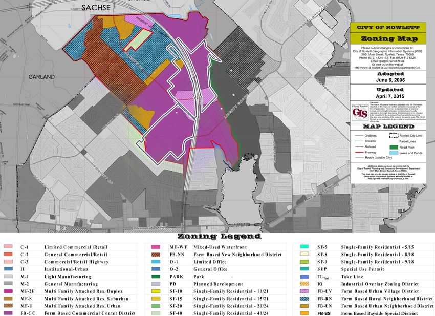
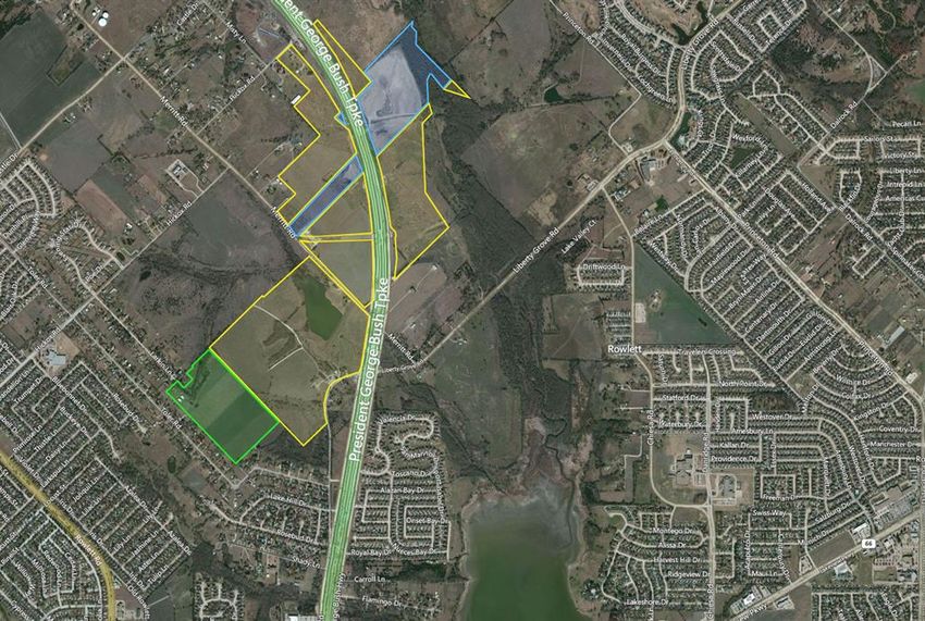
PROPERTY OVERVIEW
                            422.35+/- AC ROWLETT•SH190 DEVELOPMENT PORTFOLIO
INTRODUCTION
                            Younger Partners Dallas, LLC, a Texas licensed real estate broker, is proud to present an exceptional
                            opportunity to acquire ±422.35 acres along President George Bush Turnpike (“Rowlett-SH190 Development
                            Portfolio, The Property”) in Rowlett, Texas. This development portfolio has unique attributes with frontage
                            along the major thoroughfare in the area and inclusion within North Shore District. The offering presents
                            developers a tremendous opportunity to acquire an extremely well-positioned mixed-use development site
                            in the northeast region of the strongest housing, office and retail development market in the nation.

                                                                                            Gossett
                                                                                           ±66.88 Ac.
ROWLETT•SH 190/PRESIDENT
GEORGE BUSH TURNPIKE
DEVELOPMENT PORTFOLIO
                                                                                           McEntee
                                                                                          ±303.59 Ac.
Rowlett, Texas

                                                                                           Makvandi
                                                                          IMAGE HERE
                                                                                           ±51.88 Ac.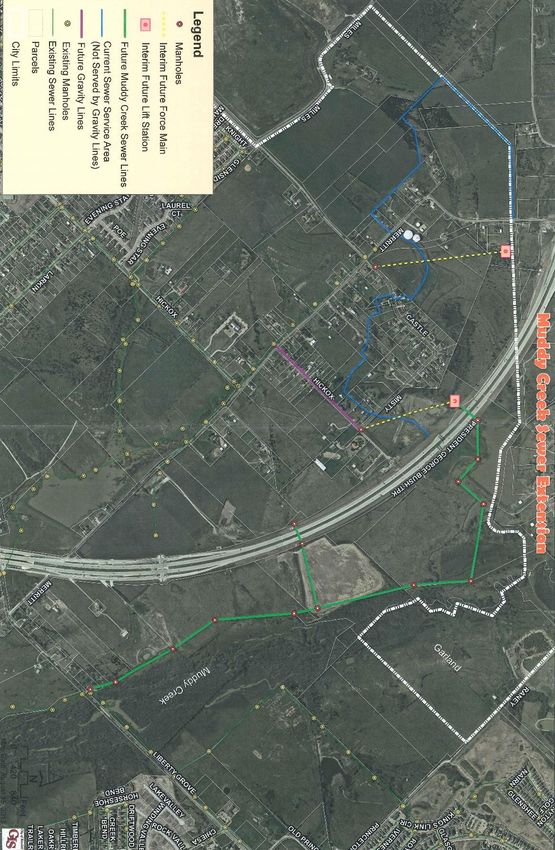
PROPERTY OVERVIEW
                                                 IN THE PATH OF GROWTH & DEVELOPMENT
INVESTMENT
HIGHLIGHTS                                       The Rowlett•SH190 Development Portfolio is located in a high growth area of Northeast Dallas-Fort Worth.
                                                 The Rowlett, Garland, Sachse and Rockwall areas have been growing at a strong pace over the past several
                                                 years. This market area has seen continued large demand for residential, retail, office and light industrial
• Rowlett•SH190 is located within the City of    development. This is one of the very last large mixed-use land plays in this part of the DFW metroplex.
  Rowlett’s North Shore District
                                                 Located on the beautiful shores of Lake Ray Hubbard, Rowlett is fast becoming a center for business and
• Prominently located along both sides of the    retail in North Texas. Rowlett is located just 19 miles east of downtown Dallas.
  President George Bush Turnpike (SH190)
  featuring excellent frontage and access        The population of Rowlett is over 58,000 and projections show the population growing to over 60,000 by
                                                 2018. Rowlett continues to focus on building its infrastructure. The North Texas Tollway Authority
• Close proximity to other major                 completed both the eastern extension of the President George Bush Turnpike (PGBT) and the Dallas Area
  thoroughfares and urban living/working         Rapid Transit Authority (DART) completed its Blue Line light rail route to in recent years, spurring a push for
  districts                                      new area residential and commercial development. PGBT conveniently connects the City to DFW Airport and
                                                 to I-30, while the DART Blue Line provides convenient access to Uptown/Downtown Dallas and surrounding
• Solid demographic profile within five mile     employment hubs.
  radius
                                                 REALIZE ROWLETT 2020 & NORTH SHORE AREA
                                                 The Rowlett•SH190 Development Portfolio is specifically located within the area’s that The City of Rowlett
PROPERTY DETAILS                                 recognizes as the North Shore North, North Shore South and the Center for Commerce & Industry. These
                                                 areas are part of the City’s Realize Rowlett 2020 and North Shore Master Plan.
LAND SIZE:        ±422.35 Acres Total
                                                 It is intended that the North Shore area be the City of Rowlett’s major employment hub. The City plans to
CITY/COUNTY:      Rowlett/Dallas                 achieve the desired development by permitting an integrated mix of uses and building types in order to
                                                 facilitate and support an employment base. High quality standards, design parameters and preservation of
ZONING:           Based on North Shore           natural features are predicted to provide an amenity package and adjacency predictability for entities
                  District requirements          developing in the North Shore area.

UTILITIES:        All adjacent or at the         DEVELOPMENT OPPORTUNITIES
                  location
                                                 •   Urban Village, Urban Neighborhood, New Neighborhood, Rural Neighborhood, Commercial Center
                                                     (details enclosed) and other uses.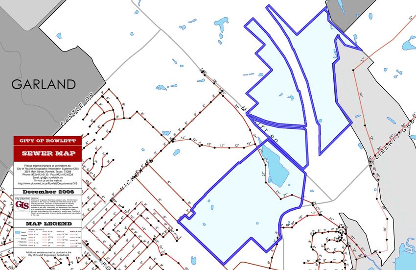
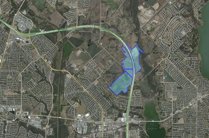
AERIL VIEW
SURROUNDING DEVELOPMENT
McENTEE LAND SURVEY
PROMINENT LOCATION
LOCATION • AREA OVERVIEW
ACCESS AND LOCATION
The Property is ideally positioned to take advantage of the nearby
transportation infrastructure. Connected to President George Bush
Turnpike (SH 190), it is easy to quickly access I-30, Highway 75, Dallas
North Tollway or Interstate 35, all Dallas-Fort Worth major freeways. In
addition, the Property is well served by several local roads, Lakeview
Parkway (TX 66), Highway 78 (Garland Avenue), and Firewheel Parkway.
PROXIMITY TO METROPOLITAN LIVE/WORK URBAN
DISTRICTS
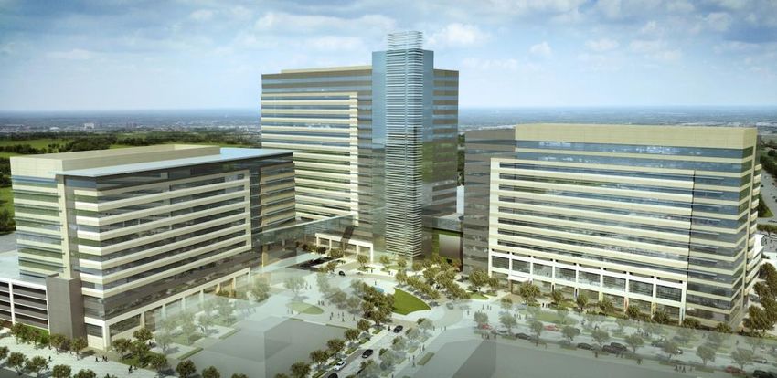
CITYLINE CAMPUS: The Rowlett•SH190 Development Portfolio is located a
short drive from the massive City Line Campus, new home to State Farm
Insurance and Raytheon headquarters in Richardson, Texas. State Farm’s
three buildings will have 21 stories, 15 stories and 13 stories, built atop Uptown Dallas is a vibrant district with a celebrated history and modern
five-level parking garages. Combined, the facilities will house up to 8,000 amenities. In Uptown there are luxury residences, world-class office space
employees for State Farm alone. The North Texas hub will provide claims, and endless shopping, dining and entertainment options. Uptown is home
service, and sales support to State Farm customers. to award winning restaurants and Dallas’ hottest bars.
Along with State Farm’s office campus, the first phase include multifamily, Downtown Dallas is seeing a new renaissance of development with its
hotel, retail and restaurant development. As ambitious as the City Line many new high rises, the world class Arts District, the new Klyde Warren
project is, it still cannot satisfy the ever growing strong demand required Park, the Perot Museum and much more. Both Downtown and Uptown
by this portion of the metroplex. Dallas are easily assessable from the property by automobile or nearby
Dart Light Rail.
DALLAS’ UPTOWN: A short distance from the Property, you will find
yourself in Dallas’ walkable, urban neighborhood of Uptown.
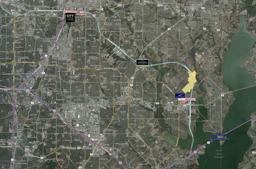
CITY OF ROWLETT
NORTH SHORE
MASTER PLAN
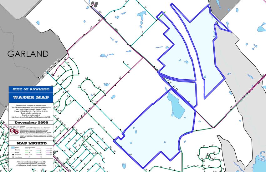
CITY OF ROWLETT WATER MAP
CITY OF ROWLETT SEWER MAP
CITY OF ROWLETT MUDDY CREEK SEWER EXTENSION
MARKET OVERVIEW
ROWLETT’S NORTH SHORE MASTER PLAN                                           north, Hickox Road to the south, and the city limit and existing New
                                                                            Neighborhood to the west. All New Neighborhood Building Types in the
North Shore South, North Shore North and Center for Commerce &              Form Based Code are allowed in this area. The maximum building height
Industry are all comprised of Form Based Districts, below is a summary of   will be 2 ½ stories.
what each district allows.
                                                                            The street system is intended to facilitate circulation for pedestrians,
The ‘RURAL NEIGHBORHOOD’: The Rural Neighborhood FB Districts are           bicycles, vehicles and emergency services. Streets are fully interconnected,
generally bounded by the city limit to the north, President George Bush     not gated and designed with a formal tree line for shade, wide sidewalks
Turnpike to the east, an Urban Neighborhood FB District to the south, and   and rolled curbs.
the New Neighborhood FB District to the west. All Rural Neighborhood
Building Types in the Form Based Code are allowed in this area. The         It is intended that centralized open space be employed to generate a sense
maximum building height will be 2 ½ stories.                                of identity, image and value creation within New Neighborhood
                                                                            developments. These open spaces can provide for neighborhood
It is intended that the Rural Estate Building Type will occur along areas   gatherings and recreation, and must be fronted by residences or
designated “Transition with Rural Neighborhood” as designated on the        community buildings. Connecting Trails may also be considered as part of
Framework Plan: Special Requirements. This 200-foot wide transition         the open space requirement.
designation sets the following parameters for lots that immediately abut
areas zoned Single Family under the RDC (SF-5 thru SF-40), which exist      The ‘URBAN NEIGHBORHOOD’: The Urban Neighborhood FB District occurs
prior to adoption of the Form Based Code.                                   in two areas: 1. Adjacent to the north city limit line along Merritt Road and
                                                                            west of Harmony Hills; and 2. Along the north side of Hickox Road east and
• The maximum principal building height will be 3 stories.                  west of Merritt Road. All Urban Neighborhood Building Types in the Form
• The maximum accessory building height will be 2 stories.                  Based Code are allowed in this area. The maximum building height will be
• The rear setback will be 25 feet                                          4 stories.

The street system is intended to facilitate circulation for pedestrians,    The street system is intended to facilitate circulation for pedestrians,
bicycles, vehicles and emergency services. Streets should be rural in       bicycles, vehicles and emergency services. Streets are fully interconnected,
character with swales rather than rolled curbs, and may employ a            not gated and designed with a formal tree line for shade, wide sidewalks
clustering of trees rather that a formal street tree line.                  and curbs.

It is intended that existing tree masses and ponds will be preserved in     It is intended that centralized open space be employed to generate a sense
parks and greenways.                                                        of identity, image and value creation within New Neighborhood
                                                                            developments. These open spaces will be improved for use as
The ‘NEW NEIGHBORHOOD’: The New Neighborhood FB District is                 neighborhood gatherings and recreation.
bounded by primarily the Rural Residential FB District to the east and
MARKET OVERVIEW
ROWLETT’S NORTH SHORE MASTER PLAN The ‘COMMERCIAL CENTER’: The Commercial Center FB District is
bounded by President George Bush Turnpike to the East, Hickox Road
The ‘URBAN VILLAGE’: The Urban Village FB District is bounded by to the north, and both Urban Neighborhood and existing single-
President George Bush Turnpike on the east, the Commercial Center family residential neighborhoods to the west. Within Overlay B, the
FB District to the north, and natural features to the south. following Commercial Center Building Types in the Form Based Code
are allowed: Commercial, Flex Employment, Mixed-Use, Shopfront
Within Overlay A, the following Urban Village Building Types in the and Mixed Residential. Where Overlay B is not designated, all
Form Based Code are allowed: Commercial, Mixed-Use, Shopfront Commercial Center Building Types in the Form Based Code are
and Mixed Residential. The following provision will be applicable allowed. Within Overlay B, the minimum building height will be 3
within the Urban Village FB District: Mixed Residential units will be stories and there will be no maximum height. One-story and two-story
evaluated as part of a larger mixed-use development, and may only buildings may be allowed under certain conditions, but will require
occupy 25 percent (excluding parks and streets) of the land area or approval of a Minor Warrant. Where Overlay B is not designated, the
building square footage in a Regulating Plan/Phased Development maximum building height will be six stories (6).
Plan or Development Plan. A request to deliver more than 25 percent
Mixed Residential will require approval by Major Warrant. It is intended that a “Transition with Buffer” will occur along areas
designated on the Framework Plan: Special Requirements. This 100-
Within Overlay A, the minimum building height will be 3 stories and foot wide transition sets the following parameters for lots that
there will be no maximum height. One-story and two-story buildings immediately abut areas zoned Single Family under the RDC (SF-5 thru
may be allowed under certain conditions, but will require approval SF-40), which exist prior to adoption of the Form Based Code.
of a Minor Warrant. The street system is intended to facilitate • The maximum principal building height will be 2 1/2 stories.
circulation for pedestrians, bicycles, vehicles and emergency • The maximum accessory building height will be 2 stories.
services. Streets are fully interconnected, not gated and designed • The rear setback will be 20 feet. A landscape buffer containing
with a formal tree line for shade, wide sidewalks and curbs. Within street trees planted an average of 25 feet on center and a 40-inch
Urban Village developments, tree grates and wells are preferred in metal picket fence with low shrubs will be provided within the rear
order to generate a “main street” atmosphere. setback, adjacent to the rear property line.
North Shore South is planned to contain centralized open space The street system is intended to facilitate circulation for pedestrians,
throughout to provide important foci for urban communities. These bicycles, vehicles and emergency services. Streets are fully
open spaces will be improved for more intense use than the interconnected, not gated and designed with a formal tree line for
residential neighborhoods with plazas, water features or other shade, wide sidewalks and rolled curbs. Within Commercial Center
amenities. All of these areas will be connected with shaded developments, planter strips are preferred in order to generate a
sidewalks and trails. lush, well-shaded public realm. North Shore South is planned to
contain centralized open space throughout in order to provide
important foci for the urban communities being created. All of these
areas will be connected with shaded sidewalks and trails.MARKET OVERVIEW CITY OF ROWLETT NORTH SHORE • EXISTING ZONING
MARKET OVERVIEW

DEMOGRAPHIC PROFILE
  Population Summary
   2000 Total Population                                   3,365    44,225   132,858
   2010 Total Population                                   5,112    59,198   165,996
   2014 Total Population                                   5,165    60,936   172,582
        2014 Group Quarters                                   0        160       560
   2019 Total Population                                   5,333    64,463   184,538
        2014-2019 Annual Rate                             0.64%      1.13%     1.35%
  Household Summary
   2014 Households                                        1,640    19,395     55,767
        2014 Average Household Size                        3.15      3.13       3.08
   2019 Households                                        1,686    20,457     59,492
        2019 Average Household Size                        3.16      3.14       3.09
        2014-2019 Annual Rate                             0.55%    1.07%      1.30%
   2014 Families                                          1,383    16,218     45,206
        2014 Average Family Size                           3.43      3.43       3.43
   2019 Families                                          1,422    17,095     48,185
        2019 Average Family Size                           3.44      3.44       3.44
        2014-2019 Annual Rate                             0.56%    1.06%      1.28%
  Housing Unit Summary
   2014 Housing Units                                      1,683   19,928    58,573
        Owner Occupied Housing Units                      83.1%     82.9%    76.0%
        Renter Occupied Housing Units                     14.4%     14.4%    19.2%
        Vacant Housing Units                               2.6%      2.7%     4.8%
   2019 Housing Units                                      1,729   20,893    62,207
        Owner Occupied Housing Units                      83.0%     83.1%    76.1%
        Renter Occupied Housing Units                     14.6%     14.8%    19.5%
        Vacant Housing Units                               2.5%      2.1%     4.4%
MARKET OVERVIEW
DEMOGRAPHIC PROFILE
Median Household Income
2014 $91,981 $84,925 $74,390
2019 $101,979 $95,338 $85,051
Median Home Value
2014 $220,975 $200,683 $198,580
2019 $251,292 $237,984 $236,379
Per Capita Income
2014 $33,817 $32,331 $29,982
2019 $38,367 $36,536 $34,373
Median Age
2010 36.9 35.1 35.1
2014 37.6 35.8 35.7
2019 37.6 36.3 36.0
2014-2019 Annual Growth Rate
2.09
2.5
2
Percent
1.5
0.64 0.55
1 0.51
0.5
0
Population Households Median Household Income Owner Occupied Housing UnitsYou can also read