ST PAUL'S RESIDENTIAL DEVELOPMENT SYBIL HILL ROAD RAHENY CONSERVATION IMPACT ASSESSMENT - 9th October 2019
←
→
Page content transcription
If your browser does not render page correctly, please read the page content below
ST PAUL’S RESIDENTIAL DEVELOPMENT
                           SYBIL HILL ROAD
                                RAHENY

              CONSERVATION IMPACT ASSESSMENT

                            9th October 2019

Historic Building Consultants
Old Bawn
Old Connaught
Bray                                             905/06
St Paul’s Residential Development, Raheny                                                                     Contents

Contents

Contents ................................................................................................................... 2
Summary .................................................................................................................. 3
Background .............................................................................................................. 4
Historical background ............................................................................................... 5
      Bibliography ...................................................................................................... 8
Conservation context................................................................................................ 9
   Record of Protected Structures ............................................................................ 9
   Conservation areas............................................................................................... 9
   National Inventory of Architectural Heritage ......................................................... 9
Building survey ....................................................................................................... 10
Proposed development .......................................................................................... 17

                                     Historic Building Consultants                                              Page 2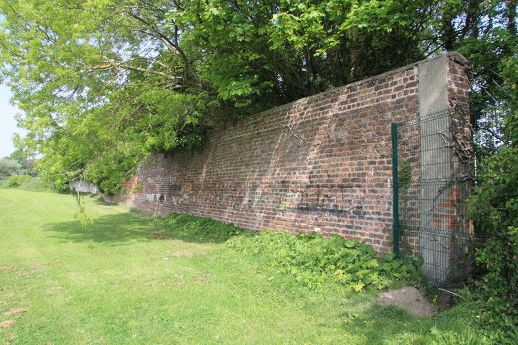
St Paul’s Residential Development, Raheny                                  Summary

Summary

This report has been produced as a historical and historic building survey of lands
to the east of Sybil Hill Road, Raheny, with an assessment of the potential impact
of a proposed residential development on architectural heritage in the vicinity.

The application site consists of a substantial area of land that is approximately L-
shaped, together with a narrower strip that runs westward to provide for access to
Sybil Hill Road. The site is adjacent to the grounds of Sybil Hill House, which is a
protected structure. The main part of the site is bounded on three sides by St Anne’s
Park, which is a conservation area – though not an architectural conservation area.

It is proposed to provide 657 apartments on the site, comprised of nine blocks of
five to nine storeys.

The proposed access will run adjacent to the buildings at St Paul’s College, to the
south of Sybil Hill House and will be separated from Sybil Hill House by the grounds
to the front of the house. It is not anticipated that the access road would have any
significant impact on the house or its setting.

The area proposed for housing is to the rear of Sybil Hill House and separated from
it by trees and outbuildings. The nearest building would be about eighty metres from
the rear of Sybil Hill House. It is not anticipated that the proposed development
would have any significant impact on the character of the house.

The application site is bounded by St Anne’s Park on the northern, eastern and
southern sides. The margin of the park is marked by a belt of trees that runs along
all three sides adjacent to the application site. On the southern side a long, broad
avenue runs through the park, from a gateway on Sybil Hill Road towards the east
and this is bounded by substantial trees. It is proposed to locate an area of public
open space on the site near to this boundary. The part of the park to the east of the
site is partly taken up with playing pitches and partly with the Millennium Arboretum.
To the north of the site there are more playing pitches in the park. The upper part of
the proposed apartments will be visible from the playing pitches, but not to the extent
that they would have a significant impact on the character of the park.

                         Historic Building Consultants                       Page 3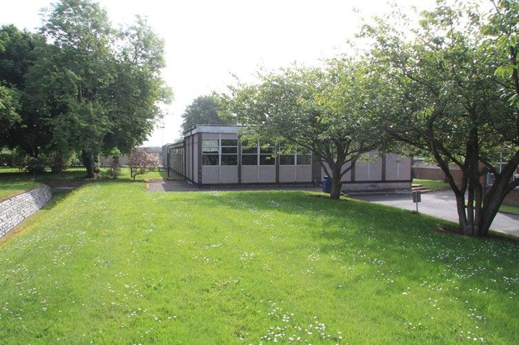
St Paul’s Residential Development, Raheny                              Background

Background

This report has been prepared for Crekav Trading GP Limited as part of the
documentation to be submitted with a planning application.

The site was inspected for the purposes of preparing this report on 11th November
2016, 24th May 2017 and 21st August 2019 on which occasions the photographs
incorporated in the report were taken and the site examined to prepare the
descriptions contained therein.

Historical research was carried out on the background history of the property and
the results are set down below.

While this report contains comment on aspects of the condition of the buildings it is
not a condition report or a structural report and must not be read as such.

This report has been prepared by Rob Goodbody BA(mod), DipEnvPlanning,
DipABRC, MA, MUBC, MIPI.

© Rob Goodbody 2017 and 2019

                         Historic Building Consultants                      Page 4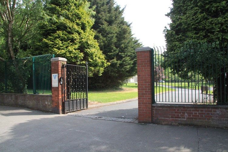
St Paul’s Residential Development, Raheny                      Historical background

Historical background

During the eighteenth century the land around Clontarf and Raheny became popular
as the location for villas belonging to the gentry and professional classes. Houses
such as Sybil Hill, Furry Park, Bay View and Verville were built during the eighteenth
century and this trend continued into the opening decades of the nineteenth century
with the construction of Bedford Lodge, Baymount Castle, Sea View and Mount
Prospect. Some of these, including Sybil Hill House, were altered and extended in
the nineteenth century, while others, such as St Anne’s, were demolished and new
houses built on the site.

      Figure 1: Detail of Ordnance Survey map of 1843, with site boundary overlaid
                                     Source: OSI

The first edition Ordnance Survey map of this area, published in 1843, shows the
villas dotted around the district. In the extract from the map that is reproduced above,
which covers a relatively small area, no less than thirteen villas are included, each
with the extent of its grounds shown with a grey stipple, while others are just outside
the area shown. The extent of the present application site is marked with a broken
red line, which shows that in the mid-nineteenth century this land was partly within
the grounds of Sybil Hill House, though mostly within the grounds of Maryville. In
this map extract St Anne’s is towards the right-hand side of the map, a little above
centre; the grounds of St Anne’s are shown as running westwards to the green line,
which depicts the boundary between the civil parishes of Clontarf and Raheny.

At the time that the map was published St Anne’s had recently been demolished
and rebuilt by the Guinness family. St Anne’s was inherited by Arthur Edward
Guinness in 1868 and in 1874-76 he enlarged the property significantly, acquiring
extensive lands to the north and west in the parish of Raheny. In 1876 he acquired
the house at Sybil Hill, with its grounds, and two years later he added Maryville,
which stood close to Sybil Hill House, to the east.

                          Historic Building Consultants                        Page 5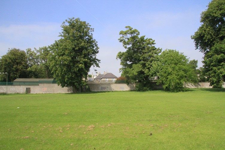
St Paul’s Residential Development, Raheny                      Historical background

Having acquired a substantial area of land to add to his estate at St Anne’s, Arthur
E Guinness, with his wife, Olivia, laid out an extensive estate, with allées and
parkland, and with extensive belts of holm oaks to give shelter from the salt-laden
sea breezes. The principal avenue, 1300 metres long, ran westwards from the front
of the house to the edge of the grounds of Sybil Hill House. However, he was not
able to acquire the lands beyond Sybil Hill House and the entrance to St Anne’s
turned northwards through the grounds of Sybil Hill House to meet the Howth Road.
The Guinnesses did not incorporate either Sybil Hill House or Maryville into the
landscaped grounds of St Anne’s and they continued to be occupied separately.

      Figure 2: Detail of Ordnance Survey map of 1907 with site boundary overlaid
                                     Source: OSI

The map extract above shows the approximate outline of the application site
superimposed on the Ordnance Survey map of 1907. Maryville may be seen in the
north-western corner of the site.

Arthur Edward Guinness was elevated to the peerage as Lord Ardilaun in 1880.
After his death in 1910 Lady Ardilaun continued to live in the house until her death
in 1925, though the estate was no longer kept up to its previous high standard. As
the Ardilaun’s were childless, the property was inherited by Lord Ardilaun’s nephew,
Bishop Benjamin Plunket.

In 1932, Bishop Plunket put the St Anne’s estate on the market, though he found it
difficult to find a buyer. In 1936 Dublin Corporation expressed an interest in acquiring
it as housing land and this was pursued through the St Anne’s Compulsory
Purchase Order (CPO), 1938, the public inquiry for which was held in September of
that year. The order was initially made for 444¾ acres (180 hectares), the greater
part of which was to be used for housing, while 176 acres (71.23 hectares) was to
be used as a public park. The property belonging to Bishop Plunket was initially
included in this total area of land covered by the compulsory purchase order, though
it was acquired by agreement with Dublin Corporation and subsequently excluded
from the order. Sybil Hill House was not included in the CPO as Bishop Plunket
retained it as his residence. Maryville was included in the CPO, but as the
Corporation’s plans for the estate were put on hold due to the outbreak of the

                          Historic Building Consultants                       Page 6
St Paul’s Residential Development, Raheny                       Historical background

Second World War the property was not acquired at that time. Maryville continued
to be occupied by Cecil Milne, under a lease granted in 1932. Cecil Milne had run a
dairy farm on the property, though during the war years he cultivated the land as a
market garden and this use continued after the end of the war. Maryville was sold
to Dublin Corporation in 1956.

In 1948 the Vincentian Fathers acquired 12.5 hectares of the St Anne’s estate from
Dublin Corporation for the purpose of building a school. The school, which they
named St Paul’s College, opened in 1952. A number of land transactions followed,
as Bishop Plunket had died in 1947 and the Vincentian Fathers had been able to
purchase Sybil Hill House from his family in 1950. In 1952 Corporation acquired part
of the lands from the Vincentian Fathers along the western side of their property, so
that they could lay out a new road to form a northward extension from Vernon
Avenue – now Sybil Hill Road. To compensate for the loss of land, the fathers
acquired land to the east of the school from the Corporation and this forms the
southern part of the lands now the subject of the present application. The house at
Maryville, with its grounds, were sold to the Vincentian Fathers in 1959. The
Vincentian Fathers demolished Maryville and laid out the grounds as part of the
school playing fields.

The land transferred to the Vincentian Fathers in 1952 extended into what is now
the Millennium Arboretum area within the park and did not allow for an efficient
layout for playing fields. A further transaction was entered into with the Corporation
in 1953 to swap that eastern part of the lands transferred in 1952 with an area to the
north. This is clarified in the map below.

The spur of land within the present site that provides the access from Sybil Hill Road
was formerly part of the grounds of Sybil Hill House.

St Anne’s Park now extends to approximately 110 hectares, as compared with the
71.23 hectares originally envisaged when the lands were acquired.

                                            C
                                                           B

                                                       A

                        Figure 3: Summary of land acquisition

                         Historic Building Consultants                       Page 7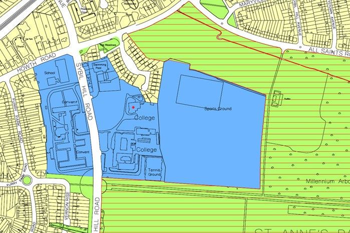
St Paul’s Residential Development, Raheny                   Historical background

The map above summarises the various land transactions relating to the present
site.

A. Land acquired from Dublin Corporation in 1952 to compensate for land sold to
   the Corporation for the laying out of Sybil Hill Road. This acquisition included
   land now occupied by the Millennium Arboretum.

B. Land acquired from Dublin Corporation in 1953 in a land swap, with the
   Corporation receiving the land now occupied by the Millennium Arboretum, to
   the east of the present site, and shown as the green area at bottom right in the
   map above

C. Lands acquired in 1959 with Maryville.

Bibliography
Dod’s Peerage, Baronetage and Knightage of Great Britain and Ireland, Whittaker
      & Co., London, 1883.

Gogarty, Claire, From Village to Suburb: the building of Clontarf since 1760,
      Clontarf Books, 2013

Hankinson, C F J (ed.), Debrett’s Peerage, Baronetage, Knightage and
      Companionage, Odhams Press, London, 1953.

Irish Times 7th September 1938

Leases relating to the property

Lennon, Colm, That Field of Glory – the story of Clontarf from battleground to
     garden suburb, Wordwell, Dublin, 2014.

Sharkey, Joan Ussher, St Anne’s – the story of a Guinness Estate, Woodfield
      Press, Dublin, 2002

St Anne’s Park website, http://www.dublincity.ie/main-menu-services-recreation-
      culture-dublin-city-parks-visit-park/st-annes-park

                         Historic Building Consultants                     Page 8
St Paul’s Residential Development, Raheny                         Conservation context

Conservation context

Record of Protected Structures
Sybil Hill is a protected structure and is included in the Record of Protected
Structures, within the Dublin City Development Plan 2016-2022, under reference
7910. This building is marked with a red asterisk on the extract from the
development plan map B, which is reproduced below.

Conservation areas
Sybil Hill is not located within an architectural conservation area and neither is the
application site. The adjacent lands within St Anne’s Park are designated as a
conservation area on the development plan maps, indicated by red hatching;
however, this is not an architectural conservation area.

      Figure 4: Detail of development plan map with application site outlined in red

National Inventory of Architectural Heritage
The National Inventory of Architectural Heritage has not yet included the Raheny
area.

                          Historic Building Consultants                          Page 9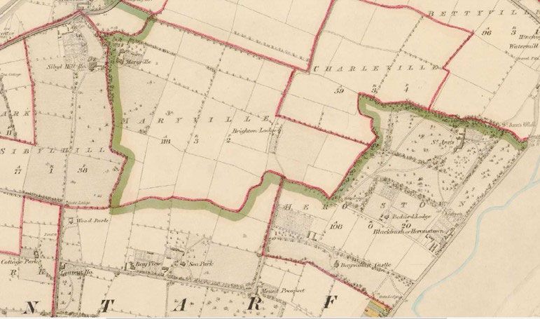
St Paul’s Residential Development, Raheny                                  Building survey

Building survey

               Plate 1: Gateway and railings at access from Sybil Hill Road

The site that is the subject of this assessment consists of a sub-rectangular area of
ground to the east of St Paul’s College and Sybil Hill House, with a narrow strip of
ground that joins it westwards to Sybil Hill Road. The narrow strip at the western
end of the site runs to the north of St Paul’s College and to the south of the protected
structure at Sybil Hill House. The present driveway leads in from Sybil Hill Road and
turns a little northward to run to the house at Sybil Hill. The gateway is flanked by
brick piers that support steel gates, while the front boundary runs in each direction,
marked by a steel fence rising from a concrete plinth wall (plate 1). The gates, piers
and railings date from the time that Sybil Hill Road was laid out in the early 1950s.

Plate 2: Site for proposed access, with St Paul’s School to right and Sybil Hill House to left

Where the driveway turns northward there is an area of grass directly ahead, to the
east, interrupted by a number of trees (plate 2).

                           Historic Building Consultants                          Page 10
St Paul’s Residential Development, Raheny Building survey
Plate 3: Site of proposed access road, with ha-ha at left
To the north of this strip there is a ha-ha that separates the grass strip from the
parking area to the front of Sybil Hill House (plate 3). To the south of this access
strip is St Paul’s College, which dates from the 1950s (plate 4). The ha-ha delineates
the setting of Sybil Hill House, which is on an elevated site on extensive landscaped
grounds and separates the grounds from the adjacent school complex.
Plate 4: St Paul’s College
Historic Building Consultants Page 11St Paul’s Residential Development, Raheny Building survey
Plate 5: Sybil Hill House, with southern elevation at right and western elevation at left
Sybil Hill House, which lies to the north of the proposed access to the site, is an
eighteenth-century, two-storey villa, which was substantially altered and extended
in the nineteenth century to give it its present appearance. The house is rendered
externally and has its main entrance facing southwards, towards the proposed
access and St Paul’s College (plate 5). The western elevation is also significant and
looks over a small area of parkland towards a grove of trees. The northern elevation
is of somewhat lesser significance but was nonetheless intended to be seen from
with the grounds of the house, particularly as the original driveway ran southwards
past the front of the house from Howth Road (plate 6).
Plate 6: Northern elevation of Sybil Hill House
Historic Building Consultants Page 12St Paul’s Residential Development, Raheny Building survey
Plate 7: Eastern elevation of Sybil Hill House
The eastern side of the house is more utilitarian and there are several outbuildings
and additions to the house on that side, beyond which are trees within the grounds
(plates 7 and 8).
Plate 8: Eastern side of Sybil Hill House, seen from application site
Historic Building Consultants Page 13St Paul’s Residential Development, Raheny Building survey
Plate 9: Prefabricated classrooms
There is a block of prefabricated classrooms on the site of the proposed access
route and these are depicted in plate 9.
Plate 10: Brick-faced wall near northern boundary
The application site, other than the strip proposed as the access, was formerly laid
out as playing fields. This is a substantial flat area of land measuring approximately
300 metres from north to south and 260 metres from east to west. This area is
surrounded on the northern, eastern and southern sides by trees within the grounds
of the adjacent St Anne’s Park. On the western boundary there are trees along much
of the boundary, particularly the northern section, which adjoins ‘The Meadows’
housing estate and the central section, which adjoins Sybil Hill House and its
outbuildings. The southern part of this boundary runs to the rear of St Paul’s College.
Historic Building Consultants Page 14St Paul’s Residential Development, Raheny Building survey
Just beyond the northern boundary of the application site is a high wall that is faced
with brick on the southern side and with brick and stone on the northern side (plate
10). This is the surviving northern wall of the walled garden associated with Maryville
and is the only extant remnant associated with Maryville. The mode of construction
is typical of garden walls of the period, with the wall built in stone, which was
relatively cheap, but faced with brick on the side facing the garden, as brick is good
for heat retention and its use to face the wall, particularly a south-facing wall,
enabled the growth of plants that would not otherwise have survived in our climate.
Plate 11: Gates to St Anne’s Park
To the south of the application site is the entrance to St Anne’s Park from Sybil Hill
Road. This is marked by a set of gates, piers and railings that are of late twentieth
century date. The gateway opens to the avenue, which was laid out in the 1880s,
originally leading to the mansion house at St Anne’s, though not forming a direct
connection to a road at the western end. This avenue is lined with evergreen oaks
and pine.
Plate 12: Eastward view along avenue
Historic Building Consultants Page 15St Paul’s Residential Development, Raheny Building survey
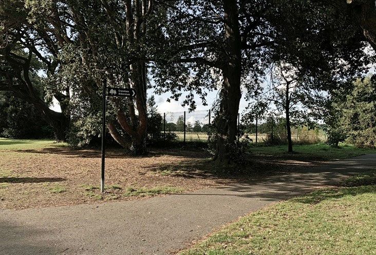
Plate 13: Boundary of park with application site at south-eastern corner
The application site is separated from St Anne’s Park by a metal fence, though the
extensive tree cover along the boundary minimises the extent to which this is visible
from the park. The fence is seen in the lower parts of the photographs above and
below.
Plate 14: South-eastern corner of application site, seen from within park
None of the boundaries of the application site are of historical significance. The
surviving wall of the walled garden of Maryville is of historical significance but is
outside the boundary of the application site.
Historic Building Consultants Page 16St Paul’s Residential Development, Raheny Proposed development
Proposed development
It is proposed to develop the larger area of land at the eastern end of the site for
residential purposes, to include nine apartment buildings of five to nine storeys each
in the northern part of the site. This would provide a total of 657 residential units.
The development will also include a crèche. The narrow strip connecting to Sybil Hill
Road would provide for the access road leading in to the site.
The proposal will involve the demolition of the single-storey disused classroom block
in the area adjacent to where the access road meets the greater part of the site.
An access road will be provided from Sybil Hill Road, running to the north of the
main St Paul’s College building to reach the main part of the site. This access road
would include new accesses to Sybil Hill House and to the college and it would
consist of a carriageway with footpath and cycleway, bounded by walls and railings,
with pedestrian and vehicular gates at the entrances to Sybil Hill House and St
Paul’s College.
Potential impact of the development
From a built heritage perspective there are two issues that need to be examined in
assessing the potential impact of the proposal – the protected structure and the
conservation area within St Anne’s Park, adjacent to the site. In examining these
issues, the principal issue relates to the operational element of the proposal. The
impacts during the construction phase are not considered to have any specific
impact in relation to built heritage.
Potential impact of access road on Sybil Hill House
The house at Sybil Hill is set in its own grounds, separated from St Paul’s College
by a driveway, a parking area and an area of lawn, with groves of trees. To the front
of the house there is a ha-ha that separates the grounds of the house from the
college grounds to the south. While this was constructed at a late date, when the
college was built, it nonetheless forms a definite demarcation between the grounds
of the protected structure and the twentieth-century college buildings and grounds.
The proposed access road would run between the ha-ha and the college building,
at a distance of almost forty metres from the house. As such, the access roadway
would have little impact on the character of the protected structure or its setting. The
gateway is of mid-twentieth century origin and is not of heritage significance and its
removal in order to provide for a wider access would not be a conservation issue.
Potential impact of residential development on Sybil Hill House
The nearest proposed building to Sybil Hill House would be apartment block 1,
which would run north-south directly to the east of the rear of Sybil Hill House and
Historic Building Consultants Page 17St Paul’s Residential Development, Raheny Proposed development
at a distance of approximately 80 metres and a height of five storeys at this location.
The eastern side of Sybil Hill House is the least significant side; the other three sides
are designed to be seen from the parkland that runs around the house, while the
eastern side faces into the courtyard of utilitarian structures and was clearly never
meant to be a significant side of the house. Conversely, the principal views from
inside the house are to the south, west and, to a lesser extent, the north, while the
east does not feature significant views. It is also noted that there are trees planted
to the east of the house and these provide screening.
It is not anticipated that the presence of Block 1 would have any significant impact
on the character of the protected structure, given the nature of the house and the
distance that would separate the new building from the protected structure.
Potential impact of development on St Anne’s Park conservation area
St Anne’s Park is an important park and provides amenities for a substantial area in
the north-eastern part of Dublin City. The park includes extensive parkland, with
walkways and lawns, it has a significant rose garden and the Millennium Arboretum.
Sections of the park are also given over to use as playing fields.
To the south of the application site there is a broad avenue that runs roughly east-
west, from a gateway fronting Sybil Hill Road at the western end, towards the site
of St Anne’s House to the east. This avenue is flanked by lines of substantial holm
oak and pine trees that provide a high evergreen wall on either side of the avenue
or allée. The proposal would also locate public open space in the area adjacent to
this avenue.
To the north of the application site there are playing pitches in the park, with a belt
of trees along the boundary line. On the eastern side the application site has more
playing pitches adjacent to the northern end of the eastern boundary, while the
southern part of the site abounds the Millennium Arboretum, which is a substantial
area covered with young trees.
The public open space within the proposed development will be in an area that is
well screened by the high holm oak and pine trees to the south and the Millennium
Arboretum to the east and will not be visible to any significant extent from the park.
The proposed landscape scheme includes for the planting of an additional
evergreen hedge along the existing boundary fence with the avenue. The
apartments would be higher and their location, on the northern side of the site, is
not as comprehensively screened at the margin of the park. While all areas of the
park are used for walking, those areas used for pitches are not as sensitive as the
parkland, the rose garden and other high-quality elements of the park and it is not
considered that the proposed development would have a significant impact on the
character of the park.
Historic Building Consultants Page 18You can also read