2020 Tropical Cyclone Operations and Research Forum Tuesday, February 25, 2020 - 74th Interdepartmental Hurricane Conference - Interagency Council ...
←
→
Page content transcription
If your browser does not render page correctly, please read the page content below
2020 Tropical Cyclone Operations and Research Forum
    74th Interdepartmental Hurricane Conference

           Tuesday, February 25, 2020

           Tom Renkevens        Thomas.Renkevens@noaa.gov
                 Division Chief
                 Satellite Products and Services Division
                 NOAA / NESDIS / OSPO
                                                            1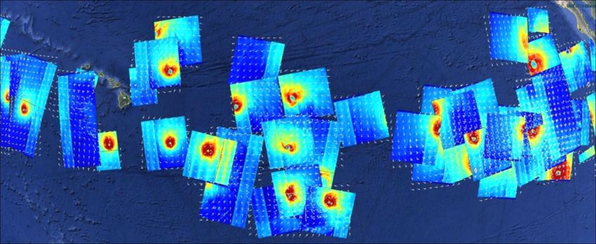
Agenda
•Satellite Status and Updates
  –GOES Constellation
     •GOES-15 termination and future use
        –Support during hot periods in August
        –No more RSO
     •Direct Readout
     •GOES-17 Loop Heat Pipe Status
     •GOES-R Product Status
  –Jason
  –Himawari
  –Meteosat
  –Polar Updates

•Product Status
  –Tropical Product Status
  –SAR (Synthetic Aperture Radar) uses for tropics

•SAB – Satellite Analysis Branch
  –Tropical Review
  –Branch Overview
  –Looking towards the future
  –Status on SAB Dvorak Analysis

•Questions and Comments
                                                Department of Commerce // National Oceanic and Atmospheric Administration // 2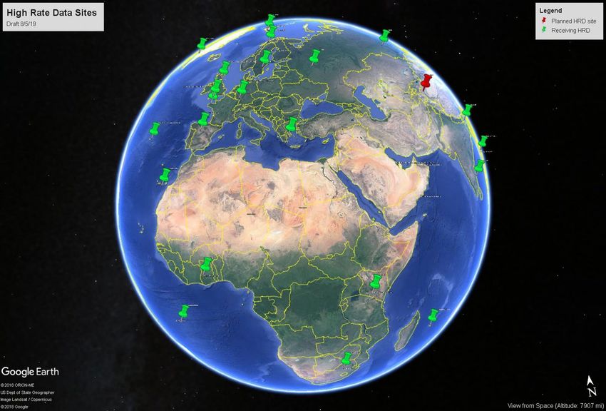
GOES-R Series Overview
    • NOAA’s latest generation of Geostationary Operational Environmental Satellites (GOES)
    • GOES-R satellites provide advanced imagery and atmospheric measurements of Earth’s weather,
    oceans and environment, real-time mapping of total lightning activity, and improved monitoring of solar
    activity and space weather
    • Benefits and Applications:
         – Improved hurricane track and intensity forecasts           – Better fire detection and intensity estimation
         – Increased thunderstorm and tornado warning lead time       – Improved detection of low cloud/fog
         – Earlier warning of lightning ground strike hazards         – Improved transportation safety and aviation route
                                                                      planning
         – Better detection of heavy rainfall and flash flood risks
                                                                      – Improved warning for communications and navigation
         – Better monitoring of smoke and dust
                                                                      disruptions and power blackouts
         – Improved air quality warnings and alerts
                                                                      – More accurate monitoring of energetic particles
                                                                      responsible for radiation hazards
The GOES-R ABI provides three times more spectral
information, four times the spatial resolution, and more than
five times faster temporal coverage than the previous
system

                                                                             Department of Commerce // National Oceanic and Atmospheric Administration // 3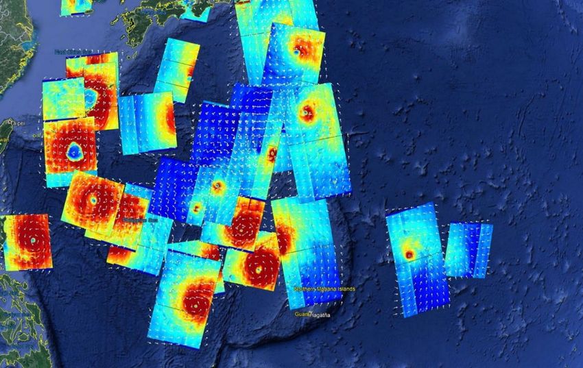
4
Department of Commerce // National Oceanic and Atmospheric Administration // 4
Current GOES Constellation
              GOES-West       Tandem GOES-West            Standby                          GOES-East
               GOES-17            GOES-15                 GOES-14                           GOES-16
              137.2° West         128° West              105° West                         75.2° West

 • GOES-15 to continue tandem GOES-West operations, ending on March 2, 2020 and then
 transition to on-orbit storage
    –NEW INFORMATION…. Plans are to use GOES-15 to support the GOES-17 during the hot period next
    August (exact dates TBD). Beyond that will depend on other possible mitigation approaches of AI and
    other….
    –Effective February 10, a recent schedule change to GOES-15 where NESDIS has suspended the daily
    generation of the GOES-15 rapid scan and full disk schedules in the workflow. These schedules can be
    put back into rotation (if needed) in a matter of hours. NWS hasn't called an RSO with GOES-15 since
    September 2018. If for some reason we need to call an RSO we can do this in a few hours during
    normal business hours and a few hours longer on the weekend or overnight.
 • Transitioned to 10 minute full disk schedules last April                                             5
 •GOES-T (GOES-18) scheduled for launch December 2021 and after post-launch checkout will
 transition to on-orbit storage
                                                                   Department of Commerce // National Oceanic and Atmospheric Administration // 5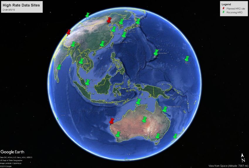
February 7, 2020 Memo

                        Department of Commerce // National Oceanic and Atmospheric Administration // 6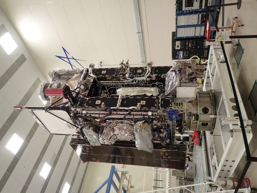
GOES-T and GOES-U Status

 GOES-T
 • Spacecraft assembled, awaiting ABI and GLM
   deliveries
 • Launch vehicle selection to be announced
   November 2019
 • Launch planned December 2021
 GOES-U
 • Integration underway
 • Preparing to add the Naval Research Laboratory’s
   Compact Coronagraph (CCOR) for coronal mass
   ejection detection                                                                  GOES-T at Lockheed

 • Launch planned 2024

  Coronal Mass
    Ejection
                                   CCOR Concept
                                                Department of Commerce // National Oceanic and Atmospheric Administration // 7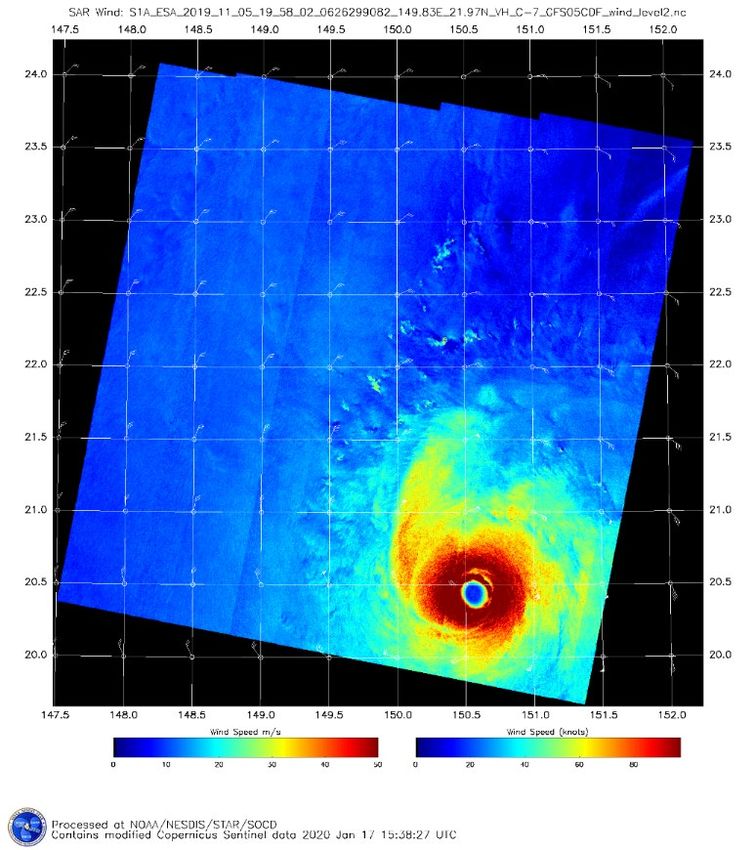
Geostationary Operational Environmental Satellite (GOES)
                  Performance Status
                                       January 23, 2020

                                                 GOES-16                        GOES-17
                                                    (East)                          (West)
                                                Launch: Nov 16                Launch: Mar 18
 Payload Instrument                            Activation: Dec 17            Activation: Feb 19
 Advanced Baseline Imager (ABI)                       G                               Y(2)                                   Key
                                                                                                                         Operational
 Space Environment I-Situ Suite (SEISS)               G                                 G
                                                                                                                               G
 Solar Ultraviolet Imager (SUVI)                      G                                 G
                                                                                                                        Operational
 EUV and X-ray Irradiance Sensors                                                                                      with limitations
                                                      G                                 G
 (EXIS)
                                                                                                                               Y
 Magnetometer                                        Y(1)                               G
                                                                                                                       Non-operational
 Geostationary Lighting Mapper (GLM)                  G                                 G
                                                                                                                               R
 Spacecraft Subsystems
 Command Data & Handling (CD&H)                       G                                 G
 Guidance Navigation Control (GNC)                    G                                 G
 Electrical Power Subsystem (EPS)                     G                                 G
 Propulsion                                           G                                 G
 Mechanisms                                           G                                 G
 Electrical Power                                     G                                 G
 Thermal Control                                      G                                 G
 Communications Payloads                              G                                 G
                                                                    Department of Commerce // National Oceanic and Atmospheric Administration // 8
Geostationary Operational Environmental Satellite (GOES)
                                Performance Status
                                                    January 23, 2020

                                      EWS-G1                  GOES-14                    GOES-15
                                       (Transit)               (Backup)               (West Backup)
                                     Launch: May 06          Launch: Jun 09            Launch: Mar 10
Payload Instrument                  Activation: Apr 10         Activation:            Activation: Dec 11
Imager                                     G                       G                             G                                     Key
                                                                                                                                   Operational
Sounder                                   R (4)                    G                           Y (3)
Magnetosphere Proton and Electron                                                                                                        G
                                           G                       G                           Y (5)
Detectors (MAGPD/MAGED )
                                                                                                                                  Operational
Magnetometers                              G                       G                             G                               with limitations

Energetic Proton, Electron, and                                                                                                          Y
                                           G                       G                             G
Alpha Detectors (EPEAD/HEPAD)
X-Ray/EUV Sensors (XRS/EUV)               Y (1)                    G                             G                               Non-operational

Solar X-Ray Imager (SXI)                  Y (2)                    G                             G                                       R
Spacecraft Subsystems
Telemetry, Command & Control               G                       G                             G
Attitude and Orbit Control                 G                       G                             G
Fuel for Inclination Control               G                       G                             G
Propulsion                                 G                       G                             G
Mechanisms                                 G                       G                             G
Electrical Power                           G                       G                             G
Thermal Control                            G                       G                             G
Communications Payloads                     G                      G                             G

                                                                              Department of Commerce // National Oceanic and Atmospheric Administration // 9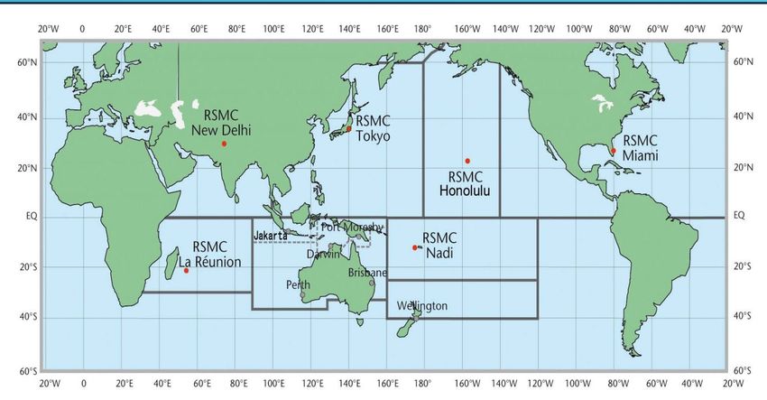
GOES-R Series Products on GRB

 Level 1b Products:
 Radiances from the Advanced Baseline
 Imager: 16 Bands; Full Disk, CONUS, and
 Mesoscale
 Solar imagery from the Solar Ultraviolet
 Imager
 Solar flux from the Extreme Ultraviolet and
 X-ray Irradiance Sensors
 Energetic heavy ions from the Space
 Environment In-Situ Suite
 Space environment magnetic field from the     Level 2 products:
 Magnetometer                                     Geostationary Lightning Mapper

                                                          Department of Commerce // National Oceanic and Atmospheric Administration // 10
GRB User Group
• GRB User Group has over 160 members and it met 4 times during 2019
• Aligned to NESDIS Strategic Objective: Provide consistent ongoing enterprise-wide
user engagement to ensure timely response to user needs
• Univ. of Wisconsin SSEC/CIMSS provided CSPP Geo software patches prior to the
GOES-R Ground System going live so that CSPP Geo users would have a smooth
transition
• Non-federal Government GRB users filed comments on the FCC webpage in regards
to the Notice of Proposed Rulemaking for Sharing the 1675-1680 MHz Band
• Members participated in a GRB Monitoring Workshop in December 2019
• Includes vendors, manufacturers, and system integrators:
https://noaasis.noaa.gov/ORGANIZATION/manu_list.html
Department of Commerce // National Oceanic and Atmospheric Administration // 11Community Satellite Processing Package
for Geostationary Data (CSPP Geo)
• Funded by NOAA GOES-R Program to create and distribute software to process direct broadcast data
from geostationary satellites, generating products in real-time. CSPP Geo software is available at:
http://cimss.ssec.wisc.edu/csppgeo/
• All CSPP Geo software is free to download and use. Capabilities include:
– Process the GOES-16 and GOES-17 GRB data streams, reconstructing the products that were
generated on the ground system
– Further process GOES-16 and GOES-17 ABI data to generate Level 2 products
ABI L1 Quicklooks ABI true color
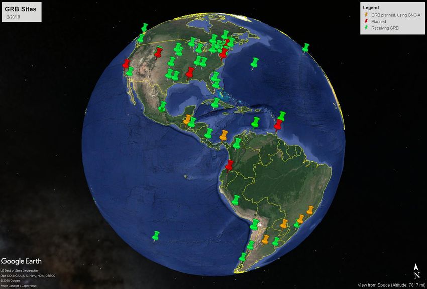
Department of Commerce // National Oceanic and Atmospheric Administration // 12• There are 61 GRB sites.
Some sites have more than 1
receive station
• There are 89 receive stations
(antennas) NOAA NWS National Centers receive GOES-16 and
GOES-17.
• Aviation Weather Center (AWC) Kansas City, MO
• NOAA Center for Weather and Climate Prediction
(NCWCP) College Park, MD
• Storm Prediction Center (SPC), Norman, OK
• Space Weather Prediction Center (SWPC) Boulder,
CO
• National Hurricane Center (NHC) Miami, FL
GRB is the primary source of GOES-16 and GOES-17
data for AWC, SPC, SWPC, and NHC
Example of a GRB Site: NASA Marshall Space Flight Center at
Huntsville, AL has 2 GRB receive stations to receive GOES-16 and
GOES-17
Department of Commerce // National Oceanic and Atmospheric Administration // 131/13/2020
Background LHP (Loop Heat Pipe)
Anomaly on GOES-17
•GOES-17 suffered an on-orbit anomaly with the one of the two
loop heat pipes that is used to pass heat from the cryocooler to
the radiator for rejection
•This anomaly causes the two of the three focal planes to rise to
temperatures observable by the infrared imaging sensors causing
saturation in certain bands
•This is most pronounced around the two eclipse seasons annually
and during those days most severe at local spacecraft midnight,
this is when the instrument is most directly pointing toward the
sun
Department of Commerce // National Oceanic and Atmospheric Administration // 14Background LHP Anomaly
•Level 1b radiance impacts are easily relatively characterized and
a Data Quality Flag (DQF) state has been added to identify when
the product is saturated due to Focal Plane Temperature (FPT)
•Different bands saturate at different times
•Level 2 products are impacted by the LHP anomaly which causes
saturation of IR bands
•Impacts to Level 2 products vary widely from product-to-product.
Some daytime-only products such as snow will see minimal
degradation while products such as cloud mask are more
impacted
Department of Commerce // National Oceanic and Atmospheric Administration // 1516
GOES-17 ABI Loop Heat Pipe (LHP) Anomaly
• The higher the ABI focal plane Diurnal Cycle of Predicted Daily Maximum ABI focal
plane
temperature, the more saturated
imagery becomes
• Temperatures approaching band
thresholds (black horizontal
lines) cause marginal saturation
• Temperatures exceeding band
lines cause unusable saturated
imagery
Annual Cycle of Predicted Daily Maximum ABI focal
plane
Graphic by David
Version July, 2019
Pogorzala
Department of Commerce // National Oceanic and Atmospheric Administration // 1617
LHP Anomaly L2 Algorithm Mitigations
Three possible approaches to mitigation impacts will be used
–DQF flags will be used to indicate when the product is degraded due to
the focal plane temperature
–In some cases channels will be substituted (e.g., apply a correction to
channel 14 and using that as a proxy for channel 13 when saturated)
–In other cases channels will be dropped from consideration in the
algorithm logic
Department of Commerce // National Oceanic and Atmospheric Administration // 1718
1/13/2020
What’s Next? Exploring Cooling Timelines
30-min Full Disk cooling timeline
Graphic by
L3Harris
Department of Commerce // National Oceanic and Atmospheric Administration // 18GOES-17 ABI Cooling Tests
• During test, nominal Mode 6 (10min FD, 5min CONUS, 1min MDS) was changed to a
combination of Mode 4 (continuous full disk, no CONUS, no MDS) for 5 minutes and
a new engineering test Mode 14 with extended space-look time periods for 25
minutes.
• Total of a 30 minute test period.
• Phase 1: 30 minute test period repeated twice to assess any unintended data
operations impacts at 1100-1200 UTC on October 15, 2019
• Phase 2: 30 minute test period repeated continuously from 0600-1200 UTC for four
days on October 18-21, 2019
Promising
initial results
(see
channels
8,9,10,12,16)
Oct 17 Oct 18
1030 1030
UTC UTC Department of Commerce // National Oceanic and Atmospheric Administration // 19Department of Commerce // National Oceanic and Atmospheric Administration // 20
21

     GOES-16 L2+ Science Product Validation Status

                                                                                                          Was 2/13/20

                                  Department of Commerce // National Oceanic and Atmospheric Administration // 21
Department of Commerce // National Oceanic and Atmospheric Administration // 22
Department of Commerce // National Oceanic and Atmospheric Administration // 23
Jason-2 Status
No Safe Holds
97.56% data capture within 3 hours, requirement 75% within 3 hours
(May 27 – Oct 1, 2019)
June 17, 2019: Began Site Acceptance Testing of new NJGS.
July 12: The first proactive gyro swap was performed. Until the end of September, Jason-2
will be running on gyros 2 and 3, letting gyro 1 rest for a while.
July 15: Cabling between ESPC and SOCC for the NJGS Refresh completed.
July 31: Station-keeping maneuver over land
Aug 13: Began receiving yellow alarms, potentially due to PCE (Power Conditioning
Equipment) section failure (investigations are currently on-going).
Sept 4: Meeting with Law on Space Operations (LOS) bureau was held at CNES.
Sept 11: Exceptional Joint Steering Group held to discuss Jason-2 end-of-life.
Oct 1: End of Jason-2 science data (no more OGDRs)
Oct 10: Official end of Jason-2 mission
Apr 20-21, 2020: Jason-2 closeout at annual Jason Exploitation Review (REVEX) meeting
Department of Commerce // National Oceanic and Atmospheric Administration // 24Jason-3 Status
Spacecraft nominal.
Safe Hold from January 31 – February 5, 2020 (triggered by gyro3 anomaly)
Brief Safe Hold recovery (5 orbits) on February 5 before reentering Safe Hold
Mode
Full Safe Hold recovery on February 13
97.63% data capture within 3 hours, requirement 75% within 3
hours (May 27, 2019 – Feb 9, 2020)
June 16, 2019: Braking maneuver performed. One OGDR impacted.
June 17: Began Site Acceptance Testing of new NJGS.
July 15: Cabling between ESPC and SOCC for the NJGS Refresh completed.
August 6: Station-keeping maneuver over land. No impact.
December 3: Station-keeping maneuver. No impact. One OGDR was impacted.
Department of Commerce // National Oceanic and Atmospheric Administration // 25Himawari-8/9 Constellation
Himawari-8 is operational at 140E
Himawari-9 is in standby at 140.7E
Planned for prime 140E operations in 2022
Himawari-9 end of life around 2030
Department of Commerce // National Oceanic and Atmospheric Administration // 26NOAA’s Himawari-8 Operational Plans
•Phase 1 (Current)
–NESDIS provides Himawari Level 2 products via the Center for Satellite
Applications and Research (STAR) ftp server with 24/7 monitoring capability
provided by the Office of Satellite Products and Operations (OSPO) and 24/7
troubleshooting capability provided by STAR.
•Current Himawari L2 products available from STAR
–Cloud Products: Cloud Mask, Cloud Phase, and Cloud Height
–DMW’s
•L1b data also available in native HSD format from
STAR via JMA’s HimawariCloud service
Department of Commerce // National Oceanic and Atmospheric Administration // 27NOAA’s Himawari-8 Operational Plans
•Phase 2 (2020-2021)
–NESDIS will move L2 PG to cloud service – L2 products
will flow from NESDIS cloud to PDA and from PDA to
customers
–Distribution of level 1b HSD data also from PDA
–Himawari L2 products planned for generation and
distribution:
•Cloud and Moisture Imagery
•Rainfall Rate
•Sea Surface Temperature
•Cloud Products
–Cloud Top Height, Clear Sky Mask, Cloud Top Phase
•Initial demonstration of capability ~ March 2020
(Level 1b products only)
•Full operational capability ~ September 2021 (Level 1b
and L2 products)
Department of Commerce // National Oceanic and Atmospheric Administration // 28HimawariRequest to Support NOAA Operations
•NESDIS in collaboration with NWS established an account with JMA to use
HimawariRequest, a service for NOAA operational offices to request
relocations of the Himawari-8 (140E) 2.5 min Target Area (floating) sector
–Enables rapid scanning of hazardous events in the Pacific Region to support NOAA
operations
–Target Area covers 1000 km x 1000 km every 2.5 min in all 16 AHI bands at full
spatial resolution
–NWS/SDM will be the point of contact for NOAA operations
•All requests will be coordinated with SDM; analogous to NOAA GOES-R MDS coordination
procedure
•JMA website provides real-time location and schedule of Target Area for current operations
–Requests for Target Area relocation will be sent via email to JMA for review and
approval/disapproval
•Requests limited to a 48 hour period; extensions are considered in extreme events
–Target Area coverage of typhoons and active volcanoes will have priority
Department of Commerce // National Oceanic and Atmospheric Administration // 29Himawari Scanning Sectors including Floating 2.5 min
Target Area (Region 3)
*Only Full Disk and Target Area/Region 3
scans will be processed at
NOAA/NESDIS*
Department of Commerce // National Oceanic and Atmospheric Administration // 30SATELLITE LIFETIME POSITION SERVICES
Current MSG Constellation 15/07/2015 – 0º SEVIRI Image
Meteosat-11 Availability lifetime 0° Data. Real-time
is until 2024 Imagery.
Rapid Scan Service
gap filling spacecraft
22/12/2005–Fuel
Meteosat-9 lifetime is until 2024
3.5° E and back-up to
prime Met-11
spacecraft
05/07/2012– Rapid Scan Service
Availability lifetime Real-time Imagery.
Meteosat-10 is until 2024
9.5° E
28/08/2002 – Fuel Full IODC service
Meteosat-8 lifetime is until 2022
41.5° E
Primary Imaging
Operations
Meteosat-11 FD
Image Department of Commerce // National Oceanic and Atmospheric Administration // 31Future Meteosat Third Generation (MTG) Satellites
•MTG-I1 (imager mission)
–Projected launch date Q3/CY2021, operational by October
2022
–16 channel imager and lightning mapper
•Temporal and spatial resolutions similar to GOES-R series
•MTG-S1 (sounder mission)
–Projected launch date Q3/CY2023
–Two Spectral bands: MWIR (4.44–6.25 µm) and LWIR
(8.26–14.70 µm)
–Spatial resolution of 4 km x 4 km at nadir
Department of Commerce // National Oceanic and Atmospheric Administration // 32S-NPP & NOAA-20 Status
Spacecraft Suomi-NPP Spacecraft NOAA-20
Launch Date Oct 28, 2011 Launch Date Nov 18, 2017
Mission LTAN 1325 (PM) Mission LTAN 1325 (PM)
Category Operational (secondary) Category Primary Satellite in PM orbit
S-NPP NOAA-20
Payload - Instruments Status Payload - Instruments Status
ATMS G ATMS G
CERES G CERES G
CrIS G CrIS G
OMPS – Nadir G OMPS – Nadir G
OMPS – Limb G VIIRS G
VIIRS G
Operational (or capable of) Operational with degraded performance
Functional but turned off
Operational with limitations (or in standby) Not functional
Department of Commerce // National Oceanic and Atmospheric Administration // 33PRE-DECISIONAL Polar Operational Environmental Satellite (POES) PRE-DECISIONAL
DATA NOAA USE
ONLY
Performance Status DATA NOAA USE
ONLY
January 24, 2020
Spacecraft
METOP-A METOP-B METOP-C NOAA-19 NOAA-18 NOAA-15
Subsystems
Launch Date Oct 2006 Sept 2012 Nov 2018 Feb 2009 May 2005 May 1998
Operational Date May 2007 April 2013 April 2019 Jun 2009 Aug 2005 Dec 1998
Mission Data Category
Operational G
Primary Operational Prime Services
Secondary (AM) Secondary (PM) Secondary (AM)
(AM) (AM) Mission (PM)
Payload Instruments Spacecraft
Issue but No S/C
AVHRR G G G G G Y(19) User Impact
HIRS Y(40) P(32) N/A O (31) R (3,43) Y (5)
AMSU-A1 O (30) Y(36) P (44) G P (33) Y(20) Investigating
Performance
AMSU-A2 G G G G G Issue which P
will Impact
AMSU-B N/A N/A N/A N/A R (11) Users
MHS G G P(45) Y (6) R(42) N/A
Operational
SEM Y(38) G G Y(39) Y(37) G with Y
Limitation
SBUV N/A N/A S/C (9) R(27) N/A
Spacecraft Subsystems Operational
with O
Telemetry, Command Degradation
& Control G G G G G G
ADACS G G G G Y (41) O (10) Non-
Operational
R
EPS G G G G G G
Thermal Control G G G G G Y(21) Not
Applicable
Communications Y (1) G G G G Y(22)
APT/LRPT R (2) R (2) R (2) G G G
DCS N/A N/A N/A N/A G G
ADCS G O(29) G Y(34) N/A N/A
SAR: SARR & SARP G Y(35) N/A G G Y(23)
Department of Commerce // National Oceanic and Atmospheric Administration // 34Polar Payload Instrument Acronyms
AVHRR Advanced High Resolution Radiometer
HIRS High Resolution Infrared Radiometer
AMSU-A1 Advanced Microwave Sounding Unit
AMSU-A2 Advanced Microwave Sounding Unit
AMSU-B Advanced Microwave Sounding Unit
MHS Microwave Humidity Sounder
SEM Space Environment Monitor
SBUV Solar Back Scatter UV Spectral Radiometer
DCS Data Collection System
ADCS Advanced Data Collection System
SAR Search And Rescue: SARR and SARP
Department of Commerce // National Oceanic and Atmospheric Administration // 35NOAA-20 Science Product Validation &
Readiness for Operations (1 of 2)
SPSRB Declared
Beta Provisional Ready for Validated
Operations
ATMS Level 1 Products
Temperature Data Record (TDR)* 08-Dec-2017 23-Jan-2018 28-Feb-2018 14-Jun-2018
Sensor Data Record (SDR) 08-Dec-2017 23-Jan-2018 28-Feb-2018 14-Jun-2018
CrIS Level 1 Product
SDR* 17-Jan-2018 16-Feb-2018 28-Feb-2018 2-Oct-2018
VIIRS Level 1 Product
VIIRS SDR 1-Feb-2018 16-Feb-2018 28-Feb-2018 15-Jun-2018
OMPS Level 1 Products
Total Column 5-Jan-2018 18-Apr-2018 7-Mar-2019 Sep-2019
Nadir Profile 5-Jan-2018 2-Jul-2018 Sep-2019 Mar-2020
VIIRS Level 2 Products(s)
VIIRS Imagery* 1-Feb-2018 16-Feb-2018 28-Feb-2018 22-Aug-2018
Validation Maturity Levels Not Validated Beta Maturity Provisional Maturity Validated Maturity
Ready for Operations SPSRB Declaration
*Key Performance Parameter (KPP)
Product quality documentation available: https://www.star.nesdis.noaa.gov/jpss/AlgorithmMaturity.php
Department of Commerce // National Oceanic and Atmospheric Administration // 36
Updated: Lihang Zhou, 01/27/20NOAA-20 Science Product Validation &
Readiness for Operations (2 of 2)
Available in Available in
Beta Provisional Validated Beta Provisional Validated
Ops Ops
VIIRS Level 2 Products VIIRS Level 2 Products
Cloud Height 23-Jul-2018 2-Oct-2018 7-Mar-2019 16-May-2019 Green Vegetation
22-Aug-2018 21-Mar-2019 4-Jun-2019 Mar-2020
Cloud Properties (night) 21-Mar-2018 21-Mar-2019 10-Apr-2019 16-May-2019 Fraction (GVF)
Cloud Properties (day) 23-Jul-2018 27-Nov-2018 7-Mar-2019 16-May-2019 Vegetation Index (VI) 22-Aug-2018 21-Mar-2019 4-Jun-2019 Mar-2020
Cloud Type/Phase 2-Oct-2018 2-Oct-2018 7-Mar-2019 16-May-2019 Vegetation Health (VH) 22-Aug-2018 21-Mar-2019 4-Jun-2019 21-Mar-2019
Cloud Mask 18-Apr-2018 2-Oct-2018 7-Mar-2019 16-May-2019 Volcanic Ash 27-Nov-2018 27-Nov-2018 7-Mar-2019 16-May-2019
Aerosol Optical Depth Ocean Color 27-Nov-2018 27-Nov-2018 Jun-2020 Jun-2020
and Particle Size 18-Apr-20181 18-Apr-20181 7-Mar-2019 16-May-2019 Sea Surface Temperature 18-Apr-20181 18-Apr-20181 7-Nov-2018 16-May-2019
Parameter VIIRS Polar Winds 2-Oct-2018 2-Oct-2018 7-Mar-2019 16-May-2019
Aerosol Detection 18-Apr-20181 18-Apr-20181 7-Mar-2019 16-May-2019 CRIS/ATMS Level 2 Products
Ice Surface Temperature 15-Jun-2018 16-May-2019 20-Jun-2019 16-May-2019 NUCAPS: AVTP,
15-Jun-20181 15-Jun-20181 7-Mar-2019 Oct-2019
Sea Ice Concentration AVMP
15-Jun-2018 16-May-2019 20-Jun-2019 16-May-2019 NUCAPS: Ozone, CO,
and Ice Thickness 15-Jun-20181 2-Oct-2018 7-Mar-2019 Oct-2019
OLR
Snow Cover (Binary
Map & Snow Cover 15-Jun-2018 16-May-2019 20-Jun-2019 Apr-2020
NUCAPS: CH4 15-Jun-20181 Oct-2019 7-Mar-2019 Mar-2020
Fraction) NUCAPS: CO2 15-Jun-20181 Mar-2020 7-Mar-2019 Dec-2020
Active Fire 18-Apr-2018 18-Apr-2018 13-Aug-2018 Feb-2020 ATMS Level 2 Products
Land Surface MiRS: AVTP, AVMP,
23-Jul-2018 21-Mar-2019 Sep-2019 Nov-2019 18-Apr-20181 18-Apr-20181 7-Mar-2019 Sep-2019
Temperature TPW
Land Surface Albedo 23-Jul-2018 21-Mar-2019 Sep-2019 Nov-2019 MiRS: Snowfall Rate 18-Apr-2018 16-May-2019 7-Mar-2019 16-May-2019
GST (Global Gridded MiRS: Other EDRs 18-Apr-20181 18-Apr-20181 7-Mar-2019 Sep-2019
Sep-2019 Sep-2020 -- Sep-2020
Surface Type) OMPS Level 2 Products
Land Surface Ozone EDR: NP 18-Apr-2018 Sep-2019 Jan-2020 Apr-2020
15-Jun-2018 21-Mar-2019 23-Apr-2019 Apr-2020
Reflectance Ozone EDR: TC 18-Apr-2018 2-Oct-2018 7-Mar-2019 Sep-2019
Validation Maturity Levels Not Validated Beta Maturity Provisional Maturity Validated Maturity
Operational Available in Operations
Department of Commerce // National Oceanic and Atmospheric Administration // 37
1 Scientifically mature pending verification of NDE implementation. Updated: Lihang Zhou, 01/27/20HRD Sites
The NOAA X/L Band antennas at Honolulu,
Anchorage, Fairbanks, Madison, Miami,
Mayaguez, and Guam provide real-time imagery
from VIIRS, AVHRR, and MODIS via onsite
processing. Images are converted to AWIPS
format and delivered to National Weather
Service Forecast Offices
Department of Commerce // National Oceanic and Atmospheric Administration // 38HRD Sites
Department of Commerce // National Oceanic and Atmospheric Administration // 39Operational Tropical Cyclone
Satellite Products Available
from NOAA/NESDIS/OSPO
ADT (Advanced Dvorak Technique)
eTRaP(Ensemble Tropical Rainfall Potential)
TCFP (Tropical Cyclone Formation Probability)
MTCSWA (Multi-Platform Surface Wind Analysis)
Microwave Sounder-based Tropical Cyclone Products
Department of Commerce // National Oceanic and Atmospheric Administration // 40ADT (Advanced Dvorak Technique)
The ADT is a computer-based technique to objectively
determine tropical cyclone (TC) intensity using operational
geostationary satellite infrared imagery.
Satellite: GOES-15/16, Himawari-8, METEOSAT, GPM, GCOM,
SSMI/SSMIS,
Formats: ASCII, PNG, ATCF
Distribution: ATCF/PDA, ASCII and PNG/web
Product webpage: https://www.ssd.noaa.gov/PS/TROP/adt.html
ADT will be upgraded to ADTv9.0 around June 2020. ADTv.9.0 will use GOES-16/17 and HIMAWARI-8
original high resolution data.
Department of Commerce // National Oceanic and Atmospheric Administration // 41eTRaP(Ensemble Tropical Rainfall Potential)
Ensemble Tropical Rainfall Potential (eTRaP) is an application that
combines TRaP forecasts from multiple satellite sensors in a "simple
ensemble" to produce improved deterministic and probabilistic
guidance for heavy rainfall in landfalling tropical cyclones.
Satellite: SNPP, NOAA-18/19, Metop-A/B, GPM, GCOM, DMSP F-
17/18, GOES-15/16, HIMAWARI, METEOSAT
Formats: ASCII, PNG, Mcidas
Distribution: ASCII and Mcidas/PDA, PNG/Web
Product webpage:
https://www.ssd.noaa.gov/PS/TROP/etrap.html Storm Micheal: 24hr rain amount
Storm Michael:24hr total Pop>50mm Storm Michael: 24hr total Pop>100mm Storm Micheal: 24hr total Pop>150mm
Department of Commerce // National Oceanic and Atmospheric Administration // 42. eTRaP was updated to include NOAA20 RR data on 08/21/2019. It is good to see both SNPP and
NOAA20 TRaPs which are around 50 minutes apart.
. eTRaP will be migrated to the cloud in 2021.
N20 0-6 HR Rainfall 23 AUG 19 17:48 SNPP 06 HR Rainfall 23 AUG 19 16:59
Department of Commerce // National Oceanic and Atmospheric Administration // 43TCFP (Tropical Cyclone Formation Probability)
6 hour objective probability estimates of the tropical cyclone formation within the next 48
hours.
Satellite: GOES-15/16, HIMAWARI, METEOSAT
Formats: ASCII, PNG
Distribution: web
Product webpage: https://www.ssd.noaa.gov/PS/TROP/etrap.html
Project plan to upgrade TCFP to use GOES-16/17, HIMAWARI original high resolution data was
approved. NESDIS started working on the project plan and the new TCFP will be running in NDE
around September 2020.
Department of Commerce // National Oceanic and Atmospheric Administration // 44Microwave Sounder-based Tropical Cyclone Products
Provide estimates of tropical cyclone maximum wind speed,
minimum sea level pressure, radii of 34, 50, and 64 knot winds in 4
quadrants relative to the storm center, and balanced horizontal
winds from 1000 to 200 mb within 600 km of the storm center. The
balanced wind is used by MTCSWA.
Satellite: SNPP, NOAA-18/19, Metop-A/B
Formats: NetCDF, ATCF
Distribution: PDA
SNPP/ATMS
Product webpage: https://www.ssd.noaa.gov/PS/TROP/amsutc.html
Metop-A/AMSU Metop-B/AMSU NOAA-18/AMSU NOAA-19/AMSU
Microwave Sounder-based Tropical Cyclone Products will be upgraded to include NOAA20 data around
June 2020. And it will be upgraded to include Metop-C data as well (TBD date)
Department of Commerce // National Oceanic and Atmospheric Administration // 45MTCSWA (Multi-Platform Surface Wind Analysis)
The multiplatform tropical cyclone surface wind analysis (MTCSWA) product produces six-
hourly estimates of the surface (10-m, 1-minute averaged) wind fields centered on active
global tropical cyclones. It combines information from several data sources to create a mid-
level wind analysis which is then adjusted to the surface.
Satellite: NOAA-18/19, Metop-A/B, GOES-15, METEOSAT
Formats: ASCII, PNG, ATCF
Distribution: ATCF/PDA, ASCII and PNG/web
Product webpage:
https://www.ssd.noaa.gov/PS/TROP/mtcswa.html
Final surface wind field for storm WUTIP
Combined AMSU balanced wind in slide 5
AMSU wind analysis for storm WUTIP CDFT for storm WUTIP
IRWD for storm WUTIP SCAT orbit over storm WUTIP
MTCSWA will be upgraded to include GOES-16/17, HIMAWARI, SNPP/NOAA20 in July 2020.
Upgrade to include Metop-C (TBD)
Department of Commerce // National Oceanic and Atmospheric Administration // 46STAR Sentinel-1 Tropical Storm Winds
NOAA/NESDIS/STAR has developed and implemented a fully
automated system to produce near real-time TC ocean surface wind
speed products: • Collect global hourly tropical storm reports (from
SAB)
• Checks for corresponding S1 imagery
• Process through SAROPS system, producing
cross-pol products (wind speed images, wind
speed contours, NRCS, KMZ, 500m-sampled
netCDF)
• Determines if the storm “eye” is in the scene.
• Produces a refined storm center location
• Produce additional TC specific products (radial
wind plots per quadrant, ATCF/radial text files,
3km-sampled wind netCDFs)
Sentinel 1A SAR Cross-Pol Winds for Typhoon
Halong • Send to web and push ATCF FIX file and 3km-
5 Nov 2019 19:58:02Z sampled netCDF to NRL, to be sent to NHC and
JTWC
Department of Commerce // National Oceanic and Atmospheric Administration // 47STAR Sentinel-1 Tropical Storm Winds
Detailed Output for Typhoon Halong (2019)
Sentinel 1A - 5 Nov 2019 19:58:02Z
Radial wind values over all 4 quadrants Contours of 34kt, 50kt, and 64kt wind
Department of Commerce // National Oceanic and Atmospheric Administration // 48STAR Sentinel-1 Tropical Storm Winds
•Created a web portal to display the products grouped
by tropical storm identifier, date, and season.
–Reprocessed all available storms from April 2018-present
–Archive contains 70 unique storms, 321 total scenes (~90
with additional analysis)
•Products include:
–surface wind speed images (500-m /3-km) (netCDF/KMZ)
–Normalized radar cross section images (NRCS)
–Radial wind plots per quadrant
–ATCF/radial text files
•Collaborated with TC experts to tailor products suited
for operational use, incl. Dr. John Knaff (RAMMB/CIRA)
and Buck Sampson (NRL)
https://www.star.nesdis.noaa.gov/sod/mecb/sar/AKDEMO
_products/APL_winds/tropical
Department of Commerce // National Oceanic and Atmospheric Administration // 49SAR Derived Tropical Cyclone Surface Winds
2018
Future Tasks:
• Aim to become the primary hub for near real-time
satellite borne SAR tropical winds data
• Process storms prior to April 2018 2018/201
• Continue to validate results of algorithm for a variety of
9
2018 storm cases (high intensity vs low intensity,
(partial)
strengthening vs weakening, basin, etc.)
• Send output products to more customers (JTWC, NHC,
Navy)
Department of Commerce // National Oceanic and Atmospheric Administration // 50STAR Sentinel-1 Tropical Storm Winds
Mean winds by quadrant: Output from NRL’s system using STAR SAR results:
ATCF FIX file:
WP, 24, 201911051958, 70, SEN1, CIR, , 2044N, 15056E, 10 , , 128, 1, , , SEN1, 34, NEQ, 60, 0, 56, 67, , , , , , ,
, W, STAR, SAR, SAR, 201911051957, 201911051958, , , SENTINEL-1A, STAR Synthetic Aperture Radar 3KM Wind Speed Analysis
WP, 24, 201911051958, 70, SEN1, CIR, , 2044N, 15056E, 10 , , 128, 1, , , SEN1, 50, NEQ, 39, 35, 33, 41, , , , , , ,
, W, STAR, SAR, SAR, 201911051957, 201911051958, , , SENTINEL-1A, STAR Synthetic Aperture Radar 3KM Wind Speed Analysis
WP, 24, 201911051958, 70, SEN1, CIR, , 2044N, 15056E, 10 , , 128, 1, , , SEN1, 64, NEQ, 27, 24, 22, 25, , , , , , ,
, W, STAR, SAR, SAR, 201911051957, 201911051958, , , SENTINEL-1A, STAR Synthetic Aperture Radar 3KM Wind Speed Analysis
Department of Commerce // National Oceanic and Atmospheric Administration // 51NESDIS – Satellite Analysis Branch
Tropical Cyclone Operations and
Research Forum
74th Interdepartmental Hurricane
Conference
Current Applications and Future Plans
Department of Commerce // National Oceanic and Atmospheric Administration // 522019 Performance Review
Department of Commerce // National Oceanic and Atmospheric Administration53
// 53SAB Analysts: More Inexperienced than 2019
Initials Years of Experience
(as of 1 JUNE 2020)
MT 26
JK 17
ER 8
JV 5
8 analysts are meteorologists
VK 4
JF 3 4 analysts are physical scientists
PL 3
(non-meteorologists)
BZ 2
*Expect 2 additional physical
KH 2 scientists to be operational by 1
JL 1 June.
MC 0
AS 0
Average 5.9 (5.1*)
Median 3.0 (2.5*)
Department of Commerce // National Oceanic and Atmospheric Administration54
// 54Quality Has Slowly Declined
Department of Commerce // National Oceanic and Atmospheric Administration55
// 55Satellite Analysis Branch
Current Overall Functions and Future Plans
• Ongoing discussions to
rehost topical analysis
in an NCEP Center that
Current Operational 24 x 7 x 365 has more commitment
to it, better mission
Legacy • Snow role
alignment and more
functions eliminated
appropriate skillsets
(meteorologists) .
• Most rain
functions
• Challenge Areas of the
transitioned
W. Pac., S., Pac and
Heavy Rain and to WPC Tropical Position
Indian Ocean products.
Snow Detection and Intensity
Classification
Existing product
areas that are
undergoing Oi
growth/enhancement l
© ESA 2010
Fire and Smoke Oil Spill and Marine Volcanic Ash Detection
Detection Pollution and Forecast
Department of Commerce // National Oceanic and Atmospheric Administration // 56NEW FUNCTIONS: SAB is being redesigned to
serve as a center for NOAA’s specialized
satellite imagery and analysis needs.
These include:
1. Satellite analysis support for major
disasters and events of concern to
NOAA HQ, LOs, NCEP and field offices.
2. Support of NWS and other
operational components of NOAA by
serving as a liaison to acquire on their
behalf or help them acquire specialized High resolution imagery, especially when
including shortwave IR, can “see” through
imagery for major event response. smoke and represent some of the many new
satellite capabilities becoming available.
3. Disaster Charter Support
Department of Commerce // National Oceanic and Atmospheric Administration // 57NOAA is a signatory to and often benefits from the “Disaster
Charter,” (more formally the International Charter for Space and
Major Disasters), but is not fully prepared to execute its role
supporting Charter activities. When staffing permits, SAB will be
able to address this shortfall.
US Charter Activations
(in the past 3 yrs)
include:
• California Fires
• Hurricane Michael
• Hurricane Florence
• Kilauea Eruption
• Hurricane Irma
• Hurricane Harvey GOES image of the largest eruption to ever
affect US airspace, the 1980 eruption of St.
Helens.
Department of Commerce // National Oceanic and Atmospheric Administration // 5859
Current planning…
•SAB is undergoing an 18 month complete system
rearchitecture to support this new role, especially
acquisition of high resolution and other specialized
satellite imagery.
•SAB manpower is focused on new skillsets supporting
these new roles, often meaning that personnel with more
remote sensing experience but less meteorology
experience are on duty.
SAB is reducing its emphasis on its legacy weather watch
missions:
its an NWS mandated responsibility
SAB’s new staffing, skillsets, systems capabilities, etc., do not
align with these missions
need to free up staff to perform new functions.
Department of Commerce // National Oceanic and Atmospheric Administration // 59Current Status / History (1 of 2)
• History - Barazotto (2005) and Benner (2011) pushed forward for retirement of tropical program
• Summer-Fall 2016 – email sent to several users directly (Eastern / Southern Hemisphere) on initial plans
• October 2016 – announcement and surveys out to users for comments, following SPSRB retirement process
• 2016-2018: Surveys and Feedback on retirement of some or all of SAB Tropical Dvorak products
• February 2017 – With NWS coordination, followed NWS AOP process to initiate proposal in NWS FY18 plans to retire products, with a
goal to be complete by end of Nov 2017
• March 2018 – inquires received from the NWS on status of the tropical program – no decisions at that time
• Early June 2018 – Dr. Uccellini and Dr. Volz discussed SAB tropical Dvorak products, and feedback was provided to NESDIS
management in mid June
• May 2018 – Briefing given to the NWS MDC (Mission Delivery Council) on SAB’s plans to terminate Dvorak and Precipitation products.
• Action from minutes: “MDC will pass the tropical requirement need to the PIC for evaluation if there’s an alternative organization
that can provide a second look to meet NHC need.”
• Did the PIC provide an alternate organization?
• Late June 2018 - Memo received from Dr. Uccellini sent to Dr. Volz – NWS opposing NESDIS Dvorak Divestiture
• July 2018 - Draft Memo from OSPO for Dr. Volz to Dr. Uccellini – replying to NWS memo, but not disseminated to the NWS
• July 2018 – NWS asked for list of SAB interpretive products.
• July/ August 2018 - Survey of NWS WFOs in regards to usefulness of SAB interpretive products. Note that the survey had a them
Asked with the theme around aviation.
• “If I could bother you for just a bit of time, could you please take a look at the following Satellite Analysis Branch products and give
me an idea of how your offices use these products from an Aviation perspective/in support of which aviation products?”
• Nov 2018 – action in NESDIS to “Identify criteria to determine types, and by extension – levels, of interpretive products NESDIS should
produce operationally”
Department of Commerce // National Oceanic and Atmospheric Administration60
// 60Current Status / History (2 of 2)
• Dec 18 2018 – Draft memo from Dr. Volz to Dr. Uccellini to continue the Dvorak products noting NWS concerns. Indicates
a review of interpretive products as well to be done in 2019. (unsure if this memo was every sent…)
• This memorandum documents the National Environmental Satellite and Information Services’ (NESDIS) response to
the National Weather Service (NWS) concerning the potential operational impacts of eliminating the Dvorak analyses
as well as other interpretative products. I acknowledge your concern and have decided to continue providing the
Dvorak analyses for the near term. In response to this request, and your priorities for the Satellite Analysis Branch, I
have initiated a review of all interpretative products to identify the organization best suited to produce them. I expect
this to be completed by xxxx, 2019, at which time I would like to engage you, and the other Assistant Administrators
to set priorities for NESDIS’ products.
• Memo from Uccellini to Volz October 2018
• Does not support SAB removing Dvorak analyses
• Received again November 2019
• March 26, 2019 – memo from Dr. Volz to Dr. Uccellini stating SAB would stop doing non NHC/CPHC areas within 120
days.
• SPSD received memo in May 2019
• Telecon w/ Ray Tanabe on June 3, 2019 to discuss Dvorak and impact to Pacific Region
• NWS provided feedback within NWS management chain
• June 25 2019 – memo from Dr. Volz to Dr. Uccellini rescinding prior memo and stating 2019 SAB will continue to provide
Dvorak analysis
• The memo discussed a review of all interpretative products to “identify the organization best suited to product them”
and then to “engage you and other AA to discuss NESDIS’ provision of interpretive products and for NESDIS to set
priorities for those products”
• Expected completion Q4 2019
• After this memo, action expanded to include all NESDIS products (IPL) beyond interpretive
• Unknown at this time status of review and next steps and timing.
• Tom Renkevens (NESDIS) and Eli Jacks (NWS) met on Dec 19 to discuss status and options.
• Davida Street (NESDIS SAB) continues informal dialog with Dave Novak and Greg Carbin (NWS WPC)
Department of Commerce // National Oceanic and Atmospheric Administration61
// 61Regional Specialized Meteorological Centers
Department of Commerce // National Oceanic and Atmospheric Administration // 62Department of Commerce // National Oceanic and Atmospheric Administration // 63
64

     Questions and Comments

                     Department of Commerce // National Oceanic and Atmospheric Administration // 64
You can also read