A Discussion of Ward Five Cultural and Heritage Resources
←
→
Page content transcription
If your browser does not render page correctly, please read the page content below
WARD        5
HERITAGE GUIDE

A Discussion of Ward Five
Cultural and Heritage Resources
                  District of Columbia
                    Office of Planning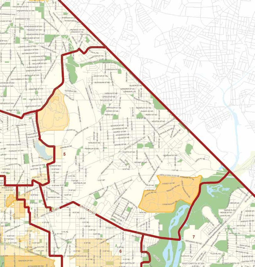
Ward Five Heritage Guide
Text by Patsy M. Fletcher, DC Historic Preservation Office
Design by Kim Elliott, DC Historic Preservation Office

Published 2014

Unless stated otherwise, photographs and images are from the DC Office of Planning collection.
Additional photographs from Deborah Crain Kemp, DC Office of Planning.

This project has been funded in part by U.S. Department of the Interior, National Park Service Historic Preservation Fund grant funds, administered by the District of
Columbia’s Historic Preservation Office. The contents and opinions contained in this publication do not necessarily reflect the views or policies of the U.S. Depart-
ment of the Interior, nor does the mention of trade names or commercial products constitute endorsement or recommendation by the U.S. Department of the
Interior.

This program has received Federal financial assistance for the identification, protection, and/or rehabilitation of historic properties and cultural resources in the
District of Columbia. Under Title VI of the Civil Rights Act of 1964 and Section 504 of the Rehabilitation Act of 1973, the U.S. Department of the Interior prohibits
discrimination on the basis of race, color, national origin, or disability in its Federally assisted programs. If you believe that you have been discriminated against in
any program, activity, or facility as described above, or if you desire further information, please write to: Office of Equal Opportunity, U.S. Department of the Interior,
1849 C Street, N.W., Washington, D.C. 20240.
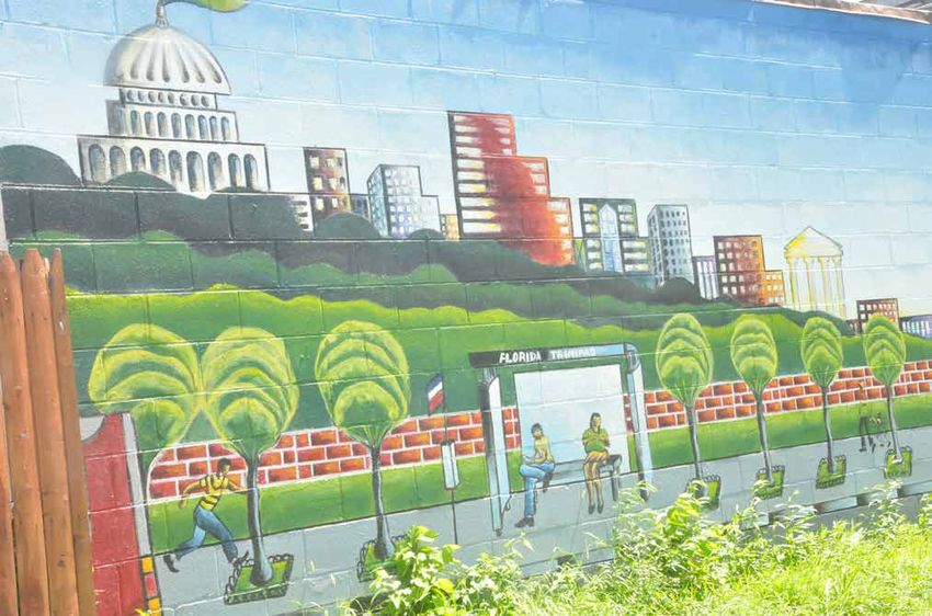
Table of Contents

                                                       Introduction............................................................................................................................................... 5

                                                       Historical Perspective............................................................................................................................ 6
                                                           Timeline
                                                           Ward Five Development

                                                       Ward 5 at a Glance ..........................................................................................................................           24
                                                               Community Stakeholders
                                                               Ward Five Neighborhoods
                                                               Attractions

                                                       Preservation Framework................................................................................................................... 26
                                                               Lost Resources
                                                               Then and Now
                                                               Preservation Challenges
                                                               Preservation Strategies

                                                       Historic Sites............................................................................................................................................ 30
                                                               Historic Landmarks in Ward Five
                                                               African American Heritage Trail
                                                               Cultural and Heritage Resources

                                                       Bibliography............................................................................................................................................ 52

Benning Road, NE looking towards 24th Street NE,1930
Historical Society of Washington DC

                                                                                                                                                                                                                       3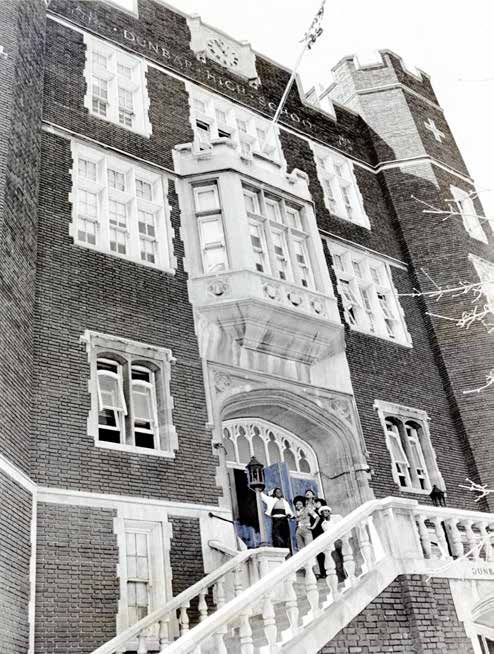
N
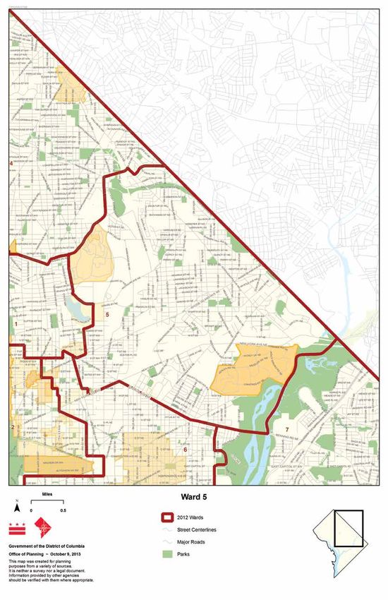
WARD 5 District of Columbia
Ward Map (2012)
INTRODUCTION

Bordered roughly by Eastern Avenue and the Anacostia River on the east,            Benefits of a Ward 5 Heritage Guide
Benning Road and Florida Avenue on the south, New Jersey Avenue and Park
Place on the west, and Rock Creek Church Road, North Capitol Street and            This guide is intended to identify historic or culturally important places in
Riggs Road on the north, Ward 5 is one of the largest in the District of Colum-    Ward 5 and to provide a framework for developing strategies necessary to
bia. Two railroad lines and several of Washington’s major arterial streets such    capitalize on and, if necessary, protect these historic resources.
as New York, Rhode Island, South Dakota and Michigan Avenues traverse the
area, which is also served by the Red, Green, and Yellow Lines of the Metrorail    A cultural or heritage resource is defined as a site, building, structure, object,
System.                                                                            or ritual of importance to a community or culture. The significance, whether
                                                                                   traditional, historic, religious, educational, or other, is one of several factors
As a result, Ward 5 has served almost from the infancy of the national capital     that illustrates the hallmarks of a community’s way of life or identity.
as an “edge city” for Washington, housing the largest concentration of indus-
trial land uses in the city along its many transportation routes. Amidst these     For many residents in Ward 5, one such resource is the Basilica on Harewood
uses are federal facilities, hospitals, cemeteries, the city’s fresh produce and   Avenue, NE near Michigan Avenue. The Basilica of the National Shrine of the
wholesale market district, many small shops and local businesses, and numer-       Immaculate Conception with its distinctive spire and decorative dome can
ous religious institutions and hospitals mostly associated with the Catholic       be seen from miles around. It marks home for many Ward 5 residents. Yet it
Church. The residential community that sprang up along the byways boasts           does not have the official historic designation of more modest yet equally
a diversity of housing stock and architectural styles from the single family       impressive landmarks of Ward 5, such as the Langston Terrace Dwellings and
homes of Woodridge and Brookland, the rowhouses of Edgewood, to the                its towering smoke stack.
apartment buildings that characterize Carver-Langston.
                                                                                   There are a number of other cultural resources in Ward 5, many of which are
Within these boundaries are numerous cultural resources of which residents         not widely acknowledged. Left unrecognized, they become vulnerable to
of the 20 plus neighborhoods feel protective and overwhelmingly proud. In          devaluation and even loss as the ward seeks investment and development.
fact, the civic activism of Ward 5 residents over the decades has demonstrated     The DC Historic Preservation Office, along with community partners, hopes
their recognition of these treasures. From the original boundary stones            to promote stewardship of the ward’s heritage by assisting residents in
delineating the District’s boundaries to magnificent religious edifices to open    identifying important cultural icons and places, and by facilitating initiatives
green areas and parks, the ward abounds with sites that contribute to and          to promote, preserve, and reuse the ward’s significant historic resources.
convey the quality of life and heritage that denotes Ward 5.
                                                                                   This guide presents a brief history of Ward 5, providing a foundation for
                                                                                   understanding the ward’s heritage. The historical overview is followed by
                                                                                   some broad strategies and suggested actions for achieving shared commu-
                                                                                   nity goals, including recognizing, protecting, and promoting use of historic
                                                                                   resources. Finally, the guide identifies some places of historical or cultural
                                                                                   significance that might be considered when development or heritage plan-
                                                                                   ning is undertaken. The intent is to address the needs, desires, and challenges
                                                                                   of the wide range of preservation interests that exist in Ward 5.

The Basilica of the National Shrine of the   Langston Terrace Dwellings
Immaculate Conception
                                                                                                                                                                        5
historical perspective
     Campsites and fishing
     villages exist on west
    banks of Anacostia River
                                       1608                                                   1632                                                   1662           1666
                        1600                                                                                         1650

                                     Captain John                                Much of what becomes Maryland is   First land patent for future             Enslavement of
                                    Smith travels up                               claimed by King Charles I and         site of DC granted                 African-descended
                                   the Potomac River                                 granted to George Calvert                                              people codified by
                                                                                                                                                                 Maryland

Native American Presence and Early European Settlements
The District of Columbia as a place of human settlement dates back some
10,000 years to the initial establishment of Native American trading posts and
hunting and fishing settlements along the Potomac and Anacostia shorelines.
Archaeological studies have established a few sites in Ward 5’s National
Arboretum.

In 1632, the English King Charles I granted the charter for the colony of Mary-
land to George Calvert, the first Lord Baltimore. Early land grants in Ward 5
dated to 1685 and included such whimsically named tracts as Turkey Thicket,
Barbadoes and Cuckhold’s Delight. Native American settlements gradually
gave way to farm homesteads and tobacco plantations with enslaved African
labor.

A hundred years later on land ceded from Maryland and Virginia, the national
capital, Washington, District of Columbia, was established. What is now
Ward 5 was formerly a part of Prince George’s County, Maryland. It was still
relatively unpopulated and largely open countryside with forests, meadows,
and farmland and four major transportation routes from Maryland to the
Potomac or to Georgetown which pre-dated Washington: the Anacostia River,
Bladensburg Road, Queen’s Chapel Road and Brentwood Road.

Except for a small corner found in the new Washington City, most of what is
now Ward 5 was located in the new County of Washington north of Boundary
Street (Florida Avenue). The roads and subsequent transportation routes
became the defining characteristic of the development of Ward 5 and informed
its identity as the industrial and institutional center of the District of Columbia.                                                     The Ellicott “10 Mile Square” map, 1794
                                                                                                                                                                 Library of Congress
6
1685       1688            1696                                       1722                      1732
                                                             1700                                                                                                 1750

Earliest land grants in Ward   European settlement   Prince George’s County             Formation of Queen’s          Beall Town, later
 5 - The Grange, Haddock’s      in Brookland area    created, including the           Chapel, Washington’s first   renamed Bladensburg,
 Hill, Turkey Thicket (1686)                              Ward 5 area                   Catholic congregation           MD founded

  A Network of Roads and Railways                                               Queen’s Chapel, another important early road, was named for the area’s
                                                                                first church (later Saint Francis de Sales). The church was established in the
  Roads                                                                         Beall’s Inclosure land grant near Bladensburg Road. In 1722, the congrega-
                                                                                tion moved from meeting in the home of the Marsham Queen family into a
  The Eastern Branch/Anacostia River at the ward’s eastern boundary once        building on their estate near where Langdon School stands today. The church
  was referred to as “one of the safest and most commodious” waterways in       had the distinction of being burned during the Revolutionary War, the War of
  America. Goods such as tobacco were sent along the river from Bladensburg,    1812, and the Civil War.
  Maryland to the Potomac. Eventually, the removal of the tree canopy for
  agriculture, among other man-made incursions caused erosion and silting,
  making the river less and less navigable.

  As tobacco farming gave way to fruit, vegetable, and grain growing to serve
  the city’s burgeoning population, the roads became even more important.
  Bladensburg Road was the most traveled route, and along its path farms,
  villages, and businesses grew. Relatively unchanged today, Bladensburg
  Road was, for example, the road taken by the British as they marched from
  Maryland into Washington during the War of 1812 and set fire to the Capitol
  and the President’s House.

  Brentwood Road (earlier a branch of Bladensburg Road) approached the ward
  near what is now Rhode Island and Eastern Avenues, and met Washington
  City near 8th Street and Florida Avenue NE. Segments of the original Brent-
  wood Road still exist, conveying the rural nature that was once all of Ward
  5. The construction of the Benning Road and Bridge at the southern border
  of the ward in 1797 permitted access to Washington City from east of the
  Anacostia River.

                                                                                                                                          East Branch of Potomac River, 1839
                                                                                                                                                              Library of Congress
                                                                                                                                                                              7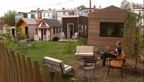
1775-1783

                                                                                       American Revolutionary War
                                                                                            1778                                            1790      1792
    1750

                                                                                     Bladensburg (Ferry)             Congress approves      Pierre L’Enfant’s grid for
                                                                                     Road to Georgetown,            creation of DC as the   Washington City excludes
                                                                                     MD already operating              national capital     most of the Ward 5 area

As Washington City expanded in the early 19th century, settlement of
the county slowly began along these byways. Large estates and summer
homes as well as modest settlements of farm workers, craftsmen and small
merchants sprang up along these few roads. In 1830, Colonel Jehiel Brooks
married Ann Queen, a descendent of Ward 5’s original white settlers, the
Marshams and Queens, and received 185 acres of the land grant Inclosure as
a dowry. In 1840, they constructed their home, Bellair, popularly known today
as the Brooks Mansion, near Lincoln and Bunker Hill (Michigan Avenue) roads.

In what is now the National Arboretum, Colonel William Hickey, in 1840,
replaced an older stone house on his property named Greenvale along
Bladensburg Road with a grander structure. In 1853, W.W. Corcoran, of Riggs
Bank and later founder of the Corcoran Gallery of Art, purchased the 99
acres that had been the Trinidad estate since 1799 of the James Barry family.
Trinidad was in the area of three major roads – Boundary (Florida Avenue
today), Benning, and Bladensburg. Corcoran may have also built a hunting
lodge in 1852 off the early Lincoln Road near the Soldiers’ Home on yet more                                                                              Bellair, Brooks Mansion
property he owned.

African-descended slaves, present in the ward by the late1600s, traveled and
lived along these roads, servicing these estates, working the land or being
hired out to work in the city. Free families of color, as well as families of many
European immigrants resided throughout the ward, also making their living
as laborers, servants, and craftsmen. These included Basil Guttridge, a free
African-American who by 1830 owned 10 acres near the site of what is now
the Turkey Thicket Recreation Center.

                                                                                                                                                             National Arboretum
8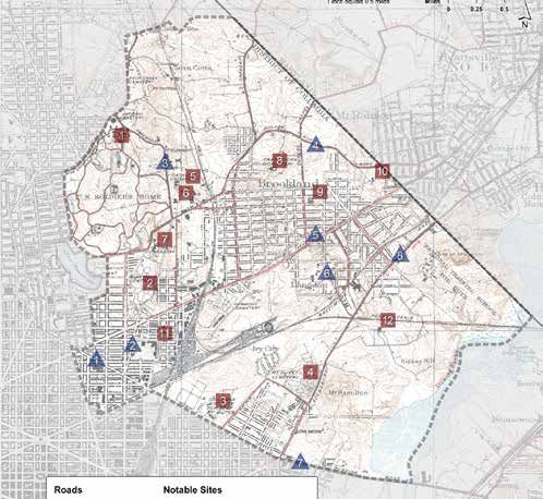
1812-1815

                                      War of 1812
                                         1814                                                                    1835             1840
1800                                                                                                                                                                    1850

Benning Bridge               British march down Bladensburg                              Washington branch of B&O Railroad     Bellair/Brooks                Benning Bridge
  completed                 Road into Washington and burn the                            opens, route is through Woodridge,   Mansion erected                  completed
                                  Capitol and White House                                 Landgon, Ivy City, Trinidad areas

  The roads also defined placement of the ward’s several burial grounds. In          Rhode Island Avenue, one of the original streets in the L’Enfant plan for Wash-
  1852, the city council prohibited new cemeteries inside the city limits. As a      ington City, was extended into Ward 5 in 1887. It became one of the principal
  result, Glenwood, Prospect Hill, Columbian Harmony, Mount Olivet, and later        routes between Washington and Maryland and served as a major impetus for
  Graceland and St. Mary’s were established in the ward. Glenwood Cemetery           continued development of Ward 5 in the 20th century.
  opened on the 90 acre-Clover Hill estate in 1852 as a secular, but segregated,
  burial ground. Mt. Olivet, the chief Catholic cemetery in Washington, is located
  on Bladensburg Road at Mt. Olivet Road, on 40 acres. It had the distinction of
  being racially integrated from its opening in 1858.

  After 1852, Columbian Harmony, an African American cemetery, was moved
  from its in-town location to the site now occupied by the Rhode Island Metro
  stop and the retail and residential development called Rhode Island Row. The
  mixed race Graceland opened in 1872 at Benning and Bladensburg Roads,
  but closed in 1894 and the burials were reinterred at Woodlawn Cemetery on
  Benning Road in Ward 7.

  The Civil War contributed to the development of another road system in the
  District. Forts Bunker Hill, Lincoln, Saratoga, Slemmer, Thayer, and Totten were
  built in the highlands of the ward, forming part of the defensive ring around
  the city. These forts were connected by roads built by the Union Army and its
  civilian employees. Irregularly shaped segments of this 1860s route still exist
  as Fort Drive and Fort Place in spite of the subdivided lands and imposition of
  the District’s Highway Plan of 1893.

                                                                                                                                                 Columbian Harmony Cemetery
                                                                                                                                                    Historical Society of Washington DC
                                                                                                                                                                                    9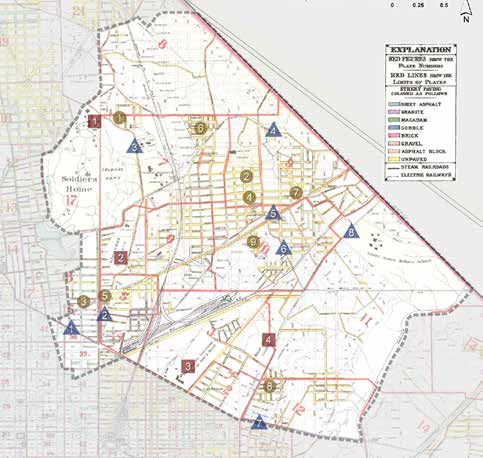
1861-1865

                                                                                                 American Civil War
                   1852                                                               1862        1863           1864           1865                                        1870          1871   1872
 1850

            Glenwood Cemetery               Compensated         Emancipation Proclamation goes into      Gallaudet, college Catholic University       District’s first   Washington        Ivy City
           established; Columbian         emancipation act                    effect                        for hearing           established          chartered       County, location developed and
        Harmony relocates to the ward   frees enslaved people                                                impaired,                                horse-drawn      of most of Ward became brick
                                            of the District            Civil War forts erected            established by Edgewood, the country trolley company         5, consolidated manufacturing
                                                                                                              Congress      estate of US Secretary   established on with Washington         center
                                                                Casting of “Freedom for Capitol Dome                           of Treasury, Sen.   Benning Road at H         City
                                                                  completed in Clark Mills foundry                          Salmon B. Chase, built     Street, NE

Railways

In 1835, the nation’s first railroad, the Baltimore & Ohio (B&O), arrived at                             Another contribution of the presence of the   Congressional passage of a compensated
the Capitol through Ward 5 from Maryland. Its Washington County path                                     wartime forts was their attraction of white   emancipation act on April 16, 1862 brought
was along Bladensburg Road to what is now West Virginia Avenue and into                                  refugees and African-descended freedom        freedom to almost 3,000 bondspeople of
Washington City. Almost ten years later the first telegraph was sent over the                            seekers from slave states also in search      the District. Among the Ward 5 slaveholders
wires placed alongside the Washington Branch of the B&O from the Capitol to                              of shelter and work. They greatly spurred     who sought compensation under the act for
Baltimore.                                                                                               Washington’s population growth and            the loss of their “property” or slaves were
                                                                                                         development of new communities. After         the aforementioned William Hickey (16),
Perhaps most significantly for Ward 5, the railway, like the later trolley and                           the war, many people of color remained in     Clark Mills (11), and Elizabeth and Mary
street car routes, spurred growth both in terms of its economic importance
                                                                                                         the areas of the forts such as Bunker Hill,   Queen (24) who held in bondage several
to the District and in terms of opening land for residential development. The
                                                                                                         establishing their own settlements.           members of the family of Basil Gutridge,
development of the latest 19th century transportation technology in Ward
5 made for easier and speedier access to Washington City and other places                                                                              a free man of color and landholder in the
beyond. New modes of transportation facilitated the shipping of manufac-                                 The Civil War initiated the liberation        Brookland area. Many of the newly freed
tured goods and produce, encouraged suburban living for city workers and                                 of people enslaved in Washington.             remained in Ward 5.
the creation of sequestered locations of social services, and locales for land-
expansive endeavors.

Examples of early development along the railroad include the location of the
bronze foundry of sculptor Clark Mills beside the B&O line off Bladensburg
Road. Here with the assistance of his enslaved foreman, Philip Reid, the Statue
of Freedom was cast before being assembled and hoisted, under Reid’s super-
vision, atop the Capitol dome in 1863. Mills’ estate was later subdivided and
became part of the Langdon/Woodridge community, marketed as desirable                                     Fort Lincoln, Library of Congress            Fort Totten, Library of Congress
and “in direct communication with the city”.
10
1879 1888 1889
1900
B&O Railroad built Eckington and Soldier’s Home Railway First building
lines through introduces District’s first electric streetcar on Catholic University
Brookland area campus opened
Brookland and Eckington areas
subdivided
Farmland of the Youngsboro tract along the B&O Railroad tracks, was subdi-
vided in 1872 as “New City” and then Ivy City. From 1879 until 1897, it was
home to the 126-acre National Fair grounds and race track, with a grandstand
telegraph office. In 1890, the Ivy City Brick Company began manufacturing
bricks for the city and became the major employer in the community. Brick
produced primarily by Ivy City and the Washington Brick Machine Company
in Trinidad furnished the materials for the District’s construction boom of the
late 1800s. United Brick Works, which later took over the brick-manufacturing
business in Ivy City was the site of the District’s first post-WWII labor strike.
In 1873, the B&O Railroad opened the Metropolitan Branch line through the
western section of the county into Washington. Brooks Station was estab-
lished on the old Bunker Hill Road near Brooks Mansion. In 1887, the 134- acre
Brooks estate would be sold and subdivided for housing, giving birth to the
Brookland community. Already home to a small enclave of African Americans
and persons connected with the Catholic University, the populations of
Brookland and University Heights would swell over the next years as white
government and other middle-class workers moved to suburban settings
and into the emerging Queen Anne, Four-Square, and Victorian Cottage-style
homes in the area.
United Brick Works
11World War I
1901 1906 1914
1900
Bloomingdale and American League Baseball Rhode Island Congress decrees reclaimed
Woodridge developed Park opened at 13th and Avenue land along Anacostia be set
Florida, NE extended up as a park
Streetcars
Horse-drawn trolleys first came to the ward in 1870, when the Columbia
Railway Company was chartered to run from New York Avenue and K Street,
NW down Boundary Street (Florida Avenue) to Benning Road. However, it
wasn’t until the development of the electric streetcar, that the ward became
a major population center.
In 1888, the Eckington and Soldiers’ Home Railway was chartered and the
District’s first electric streetcar ran from 7th Street and New York Avenue to
Eckington Place at 4th Street, NE. In 1890, it was extended and in 1890 began
operating along 4th Street to Bunker Hill Road/Michigan Avenue. Subsequent
extensions ran along Lincoln Road to the entrance of Glenwood Cemetery Opening of Eckington - Old Soldier’s Home streetcar line, 1888
Historical Society of Washington DC
and along North Capitol from New York Avenue to the Old Soldiers’ Home.
As a result, coupled with the presence of the B&O freight yards, not only did
Eckington become Washington’s major industrial center, its residential devel-
opment was stimulated by the easier travel to and from Washington and city
employment.
In the 1890s, housing was built in other sections of the ward on subdivided
former estates and farms. Some of these subdivision names, such as Metropo-
lis View and Avalon Heights have disappeared, but other county suburb
names such as Bloomingdale, Edgewood, South Central and Woodridge have
taken their place. Clusters of detached houses were also built from University
Heights through central and eastern Brookland to the Langdon and Fort
Lincoln areas, all served by the street-car network and new streets.
Bloomingdale rowhouses
12World War II
1927 1930 1931 1935 1939 1945
1950
Congress authorizes Arboretum Ward 5 Civil War fort sites Construction begins for Langston Golf Course Labor Strike at Major industrial
establishment of community became part of the Langston Terrace Dwellings opened for United Brick development
the National Arboretum established Fort Circle Drive project African American golfers Corporation along B&O tracks
Roads for Automobiles struggle ended, the neighbors prevailed and funding was diverted from the
proposed freeway to Metrorail construction. Today there are three Metro
The advent of automobiles and later buses and trucks necessitated new or stations in Ward 5 that align with the original Metropolitan Branch of the
improved roads. These were built along with or over streetcar tracks, and B&O railroad tracks: Rhode Island Avenue, Brookland/Catholic University of
made way for commercial and residential development along Rhode Island America, and Fort Totten.
Avenue, North Capitol Street, South Dakota Avenue and New York Avenue.
Construction of auto-accessible detached homes took place in the Fort The roads and transportation have always been a major influence in the
Lincoln, Arboretum, eastern Brookland and Woodridge neighborhoods development and identity of Ward 5. The mid-1950s extension of North Capi-
moving northward along South Dakota Avenue into Queens Chapel and tol Street, together with the laying of South Dakota Avenue and rerouting of
Michigan Park, and north into the Lamond and Fort Totten areas where clus- Michigan Avenue, only increased the network that, along with the subway
ters of rowhouses were also built. Many of these newly developed communi- stops, makes Ward 5 today one of the most travelled locations in the city.
ties had restrictive covenants barring blacks from buying in.
Along Rhode Island Avenue at Brentwood, the first large-scale Federal Hous-
ing Administration (FHA)-sponsored project in the District, Brentwood Village
(now Brookland Manor), was built between 1938 and 1943, and included
a whimsical Tudor-style auto-related, drive-in shopping center. During the
same period large apartment buildings, like the Metropolitan on Rhode Island
Avenue, complete with garages at the rear for tenants’ vehicles, were also
taking their places along the ward’s main corridors.
While the civically-active Ward 5 residents had welcomed construction of
roads, they objected to attempts to bring in the next generation road – the
highway. Ivy City, for instance, opposed efforts in the 1960s to place a
segment of a six-lane highway cutting through its community under Mt.
Olivet Street. In Brookland, between the mid-1960s to 1977, a coalition of
local civic groups fought the plan to place I-95 through their community.
Although 69 rowhouses south of Lawrence Street were razed before the “Trinidad Boys Club” Car wash in Langdon
Historical Society of Washington DC
131952 1955 1965 1969 1972 1980
1950
Major industrial Riggs Park, last but largest McKinley Brookland residents file suit to Metro construction Plans for Fort Lincoln Nation’s largest Safeway
development undeveloped subdivision, Technical High halt freeway through the for three Red Line community initiated Store opens at Hechinger
along B&O tracks comes under construction School integrates community stations begins Mall on Benning Road
Institutional Development Colleges and Universities
Beginning in the 19th century, institutions began to locate in the ward, often Gallaudet University, founded by an Act of Congress in 1864 as the National
to take advantage of the higher grounds and rural settings. One of the oldest Deaf-Mute College, is the only American institution of higher education
is the Soldiers’ Home, opened in 1851 off Harewood Road on land purchased devoted to deaf education. In 1894, the name of the college was changed to
from George T. Riggs. An 1842 cottage on the Harewood estate became the honor the man, Hopkins Gallaudet, who founded the first school for the deaf
summer home of many U.S. presidents including President Lincoln for whom in the nation.
the building is now named. The Soldiers’ Home (now called the Armed Forces
Retirement Home) is one of the oldest military retirement homes in the In 1889, after almost 20 years of planning and fund-raising, The Catholic
nation. University of America formally opened its doors on 65 acres that had been the
Middleton estate near the Brooks Mansion. The university expanded steadily,
and by 1919, had 15 buildings. It attracted more than 20 Catholic houses of
study, convents, and seminaries, including Trinity College for women (1897)
and the Franciscan Monastery (1898). The area became known affectionately
as “Little Rome”. Its main street became Twelfth Street once the Monroe Street
bridge was built bringing the streetcar into Brookland. The commercial strip,
anchored by a Masonic hall and post office built in 1911, was inter-faith, inter-
ethnic and inter-racial, boasting many small businesses and institutions.
Albert Hall, The Catholic University
141998 2004 2007 2012 2013
2000
Congress allocates initial Brookland ANC votes Rhode Island Place Rhode Island Row Langdon Park renamed for
funding for Metropolitan against creating a retail development mixed-use renowned musician and former
Branch Trail Brookland historic district opens development opens Ward 5 resident, Chuck Brown
Secondary Schools
The earliest public elementary schools in the ward included Brentwood
Road (1870), and Brookland (1891) for white students. Bunker Hill Road
(1883) initially opened for white students but was reassigned to the “colored”
division in 1900. It was the only black school in the northeastern part of
the ward until 1911 when the Crummell School was built in Ivy City. In the
far southwest section of the ward, Slater School opened in 1890 for African
American students and was immediately overcrowded. The proposal to
add an adjoining school to relieve the overcrowding was met by vociferous
protests from the white North Capitol and Eckington Citizens Associations
delaying the construction of Langston (1902) for over two years. Two white
elementary schools were built in Eckington around the turn of the century:
Eckington with its elaborate terra cotta trim opened in 1898, and Emery, on
Lincoln Road, in 1902.
McKinley Technical High School for whites was relocated to Eckington in
1928 into a new, stately building. It was DC’s 6th public high school for white
pupils. Dunbar Senior High and Armstrong Technical Schools, also in Ward 5,
would remain Washington’s only black high schools for over two decades. In
the 1950s, Spingarn High School in the southeast section of the ward opened
as the District’s fourth public high school for African American students.
Among the Catholic schools in Ward 5, St. Benedict’s Academy opened in
Brookland in 1906. Housed in the Brooks Mansion, it later became Northeast
Catholic High School, and the St. Anthony’s School opened in 1922 to handle
the elementary grades. Holy Name School opened in a new building in
Trinidad in 1924.
McKinley Technical High School
15Religious Institutions Social Service Institutions and Hospitals
Settlement of the ward was also accompanied by the establishment of The National Training School for Boys, established in 1871, moved in 1872
churches. The earliest were related to the Catholic Church, the faith of the first from Georgetown to what grew to be well over 250 acres off Bladensburg
European settlers in the area who were Catholic. Queen’s Chapel evolved from Road near South Dakota Avenue. The area was known as Fort Lincoln for the
a private chapel to serving the needs of the Catholic community of the ward. Civil War fort partially located on the site. The school closed in the 1960s, and
Once The Catholic University of America was established in the ward, the much of the property was later turned into an upscale community of town-
number of ancillary institutions rapidly developed. house-style condominiums, rental apartments and senior housing enjoying
spectacular views of the city.
Among the oldest extant non-Catholic church buildings in the ward are the
chapel at Glenwood Cemetery (1892) and the Brookland Methodist Episcopal The Lutheran Home of the Aged, later the Washington Center for Aging
Church (1895), now Immanuel Bible Assembly. The first decades of the 20th Services, began as a 27-acre bequest in 1890 for an elderly-care home.
century, as the population of the ward was beginning to expand, saw a Although it was built in 1894 in Langdon as a series of cottages, by 1913 it
growth in the number of Protestant Church structures ranging from high- had been replaced by the large brick edifice seen today.
style architecture such as the Memorial Church of the United Brethren, now
Metropolitan Wesley AME Zion Church to vernacular. Many exist today. St. Vincent’s Orphanage Asylum and Catholic School took over the 1863
Edgewood estate of Salmon P. Chase, Secretary of the U.S. Treasury under
President Lincoln, and U.S. Supreme Court Justice. The orphanage and school
for girls operated on the site from 1900 to 1968. Other institutions included
the Ionia R. Whipper Home for Unwed Colored Mothers opened first in 1931
on Florida Avenue near 5th Street, NW and later moved to Woodridge. It now
operates as a shelter for young women of all races.
The District’s longest continuously operating hospital is Providence in Ward
5’s North Michigan Park, a Catholic hospital chartered in 1861 by President
Lincoln. Additionally, the complex of private hospitals in the heights of North
Capitol Street at Michigan Avenue includes the 47-acre Washington Hospital
Center, DC’s largest, founded in 1958 when three existing hospitals merged. It
stands adjacent to the Children’s National Medical Center (founded in1870, in
this location since 1970s), the DC Veteran Affairs Medical Center, and the more
recent National Rehabilitation Hospital.
Brookland Methodist Episcopal Church / Immanuel Bible Assembly
16Bates Street’s
“Sanitary Housing”
While not an “institution” per se, the Washington
Sanitary Improvement Company’s first housing was built
between 1897 and 1902 on Bates Street, NW just west
of North Capitol Street. The intention of WSIC, headed
by George Sternberg, was to provide decent, affordable
rental housing for Washington’s low-income alley
residents. Built as “houses” with two four-room flats
each, most were rented to white tenants. The renovation
of this housing for home-ownership by the low-income
became a focus of Washington’s Model Cities program in
the 1970s.
The National Training Center for Boys (razed)
Eckington Presbyterian Church (razed), Historical Society of Washington
17Other Resources A Hub of Industrialization
Into the early 20th century, certain sections of the ward remained open With its surfeit of roads and railways, and its expanse of undeveloped land,
country ripe for the siting of land-intensive endeavors. In the eastern section Ward 5 was a natural location for the industrialization and commercialization
of the ward, these included the American League Baseball Park (1901-1926) needed to support an increasingly denser Washington City. Eckington and
at the corner of Florida and Trinidad Avenues; a refuse dump and incineration Truxton Circle, in particular, with its railroad and streetcar lines, were home
plant (1919-1955) at Montello Avenue and Mt. Olivet Road. Additionally, the to numerous warehouses, food processing, and manufacturing plants of
western section of the Anacostia Park (authorized in 1918) and the National such companies as Schlitz Beer, the Stone Straw Company, and the National
Arboretum (established in 1927) were located in the ward. In 1935, construc- Biscuit Company, better known as Nabisco. In spite of the emergence of large
tion on the nation’s first public housing development for African Americans, commercial establishments in the neighborhood over the years, the residen-
Langston Terrace Dwellings, was begun. Shortly thereafter, Langston Golf tial community here and in other industrialized sections of the ward remained
Course for blacks was opened in the Anacostia Park area. stable and permanent.
In the western section of the ward, the 25-acre Olmsted-landscaped sand
filtration site of the McMillan Reservoir assumed a commanding position
above Bloomingdale in 1905. Part of a larger complex that was the city’s first
water treatment facility, the sand filtration system represented a technologi-
cal advancement in providing clean water to residents.
McMillan Sand Filtration Site
Union Market c. 1948
American League Baseball Park at Florida and Trinidad Avenues, circa 1920 Historical Society of Washington DC, Wymer Collection
18The industrial heyday of the 1950s soon gave way to decline. On the heels of
advancements in travel, at the turn of the 20th century, large-scale commer-
cial and industrial enterprises left Washington City for the new suburbs.
By the 1980s, history had repeated itself, with commerce eschewing the
outmoded train transportation and routes, and embracing the development
of new modes of transport and alternative transportation routes, especially
freeways. Ward 5 retail businesses were finding it difficult to compete with the
shopping centers in the outlying suburban areas. Though some new facilities
were built, such as the Brentwood Postal Facility and the corporate head-
quarters for Black Entertainment Television (BET), the industrial firms sought
the expansion space, inexpensive land, and truck and auto access from the
Beltway offered by the suburbs. Many Ward 5 communities began to show
signs of disinvestment from both the private and public sectors.
National Geographic Society Warehouse The 21st century is seeing a resurgence of the use of the historic industrial
and commercial buildings in Ward 5. Adaptive reuse as apartments, retail,
During the first half of the 20th century, through the world wars, the offices, and even light industrial such as distilleries and technology centers
Baltimore-Washington Parkway opened and New York Avenue was extended among other uses promotes preservation of the ward’s sound building stock
from Bladensburg Road to the District line. These routes replaced Rhode and keeps it in circulation.
Island Avenue as the city’s gateway to the northeast. Both the increase in the
trucking industry and the rail lines stimulated major industrial construction.
The Union Market Terminal, also known as the Florida Avenue Market, opened
in 1931 on the site of the former Camp Meigs, a World War I army camp. Built
after DC’s downtown Central Market closed, it was ideally located on a major
byway and along the railroad.
Large warehouses were built along the B&O and Pennsylvania Railroad tracks,
especially in the Fort Totten area. Ivy City, between New York Avenue and the
freight yards, also became the site of large scale warehouses and manufactur-
ing, though residents fought the rezoning of the neighborhood as commer-
cial. The local department store, Hechts, located its stunning streamlined
moderne-designed warehouse along New York Avenue. International style
and Art Deco-styled warehouses in Ward 5 include an IBM punch card factory,
Kraft Foods on Queens Chapel Road and a Fleishmann’s Yeast factory on
Bladensburg. Residential communities like Gateway and Arboretum thrived in
the shadow of these industrialized corridors. Judd and Detweiler Printing Company / XM Radio building, 1500 Eckington
19Coming Into the 21st Century
Ward 5’s racial composition began to change from white to predominantly Today, Ward 5 is enjoying a rejuvenation. The population has grown and
black in the 1950s. In those post-World War II years, Brookland was considered neighborhoods like Truxton Circle, Bloomingdale and Eckington are attract-
by the Washington Post as the most prestigious neighborhood in the city for ing investment both in terms of capital developments and as sought-after
blacks. Senator Edward Brooke, Ralph Bunche, a prominent international advi- addresses for young white and black professionals. The redevelopment of
sor and first black Nobel Peace Prize recipient, renowned artist Lois Maillou NoMA (North of Massachusetts) with office and residential buildings accom-
Jones, and diplomat Patricia Roberts Harris were among the many prominent panied by retail and the opening of the New York Avenue Metro station has
black residents of Brookland. Several lived in homes designed by African transformed the area into a bustling hub. The area will receive a further boost
American architects. once the implementation Mid-City East Plan begins.
In the late 1940s and early 1950s court rulings outlawed segregation and Similar treatment is in progress for the Rhode Island Avenue and Brookland/
the enforcement of housing restrictions. As a result, black families began to University Heights transportation hubs. Longstanding institutions like
move, principally as homeowners, into such neighborhoods as Woodridge, DancePlace are receiving makeovers in the form of brand-new facilities while
previously off limits due to racial covenants. The 1954 school desegregation warehouse and other commercial structures are being made over by new
decision, Brown v. Board of Education, led many white families to move west of enterprises and uses.
Rock Creek or to the Virginia and Maryland suburbs, freeing up hundreds of
houses. Communities in the upper northwest area of the ward, such as North
Michigan Park, and Riggs Park (1954), became attractive to middle income
black families seeking homeownership in low-density neighborhoods with
convenient and acceptable schools. By 1960, blacks accounted for 54 percent
of the total population in the ward. Neighborhoods like Brentwood, Edge-
wood, and Carver, attracted residents seeking affordable housing. They often
occupied overcrowded, single-family homes and apartments or the newly
constructed subsidized dwellings such as Edgewood Terrace and Montana
Terrace.
On the other hand, Trinidad became victim to massive real estate scams from
which it is barely recovering today. In the late 1970s this affordable communi-
ty became the object of real estate speculators who illegally obtained federal
mortgage insurance to buy and then subvert rent control laws and raise rents.
This in turn forced out long-term stable renters and homeowners only to be
replaced by transients and drug traffickers. Though Trinidad was not the only
neighborhood victim of such fraudulent practices, the effects were more
devastating here than any other place in the city.
Trinidad-Ivy City Community Garden Club
20Fort Lincoln, subject of a 1970s initiative to stimulate reinvestment in the Even with the development and redevelopment, Ward 5 still retains a sense of
ward, was planned as a site for a new community with housing for people of broad diversity and suburban openess. Some sections remain industrial, and
diverse incomes, shopping and recreational facilities, an employment center, some, bucolic; yet others are considered hip and urbane. The “tiny” houses of
schools, and convenient transportation to downtown. High-end and senior the Stronghold neighborhood strive to demonstrate “green” living. Poverty
housing was constructed in the 1980s and 90s but only now have the rest of still exists alongside wealth. Just as Ward 5 neighbors came together to
the plans come to fruition with the development of suburban-type big box oppose and defeat plans for a crosstown freeway through their communities,
retail and new high-density residential living. so have they been able to come together to create such projects as Crispus
Attucks Park and the Brookland Garden Tour for community good. The incred-
Some long-standing landmarks of the ward, such as the Union Market Termi- ibly rich path to development for the ward continues today.
nal/Florida Avenue Market, Soldiers Home, and McMillan Reservoir are being
redeveloped hat compromises the historical character they now convey. The
ever civically engaged Ward 5 residents are keeping close watch on these
resources. However, the installation of amenities such as the Metropolitan
Branch Trail along the old B&O/now CSX tracks, renaming parks to recognize
local heroes, and incorporating dog parks in existing parks have added to the
quality of living.
“Tiny House”
New Dance Place building under construction boneyardstudios.com
21Mural in Trinidad neighborhood 22
Ward Five Development                                                       1861
The following maps are used to demonstrate the development of Ward 5 over
time. They provide a graphic representation of the history of the area.

                                                                            1861 A. Boschke map

                                                                                   Roads                                                            Notable Sites

                                                                              1    Florida Avenue            6 Queens Chapel Road              1    Soldier’s Home
                                                                              2    Lincoln Road              7 Benning Road                    2    Glenwood Cemetery
                                                                              3    Harewood Road             8 Bladensburg Road                3    Gallaudet University
                                                                              4    Bunker Hill Road                                            4    Mt. Olivet Cemetery
                                                                              5    Brentwood Road

                                                                            All historical maps in this section have been adapted by Brian Kraft.
                                                                                                                                                                           23
1878 1892
Roads Notable Sites
1 Florida Avenue 6 Queens Chapel Road 1 Soldier’s Home
2 Lincoln Road 7 Benning Road 2 Glenwood Cemetery
3 Harewood Road 8 Bladensburg Road 3 Gallaudet University
4 Bunker Hill Road 4 Mt. Olivet Cemetery
5 Brentwood Road
1878 G.M. Hopkins map 1892 NOAA Map of Suburban Subdivisions
Roads Notable Sites Subdivisions
1 Florida Avenue 6 Queens Chapel Road 1 Soldier’s Home 1 Clark Mills, 1885 7 South Brokland, 1889 12 University Heights, 1890
2 Lincoln Road 7 Benning Road 2 Glenwood Cemetery 2 Brookland. 1887 8 Woodridge, 1889 13 Addition to LeDroit Park, 1891
3 Harewood Road 8 Bladensburg Road 3 Gallaudet University 3 Dobbin’s Addition, 1887 9 Avalon Heights, 1890 14 Center Eckington, 1891
4 Bunker Hill Road 4 Mt. Olivet Cemetery 4 Eckington, 1887 10 Edgewood, 1890 15 Metropolis View, 1891
5 Brentwood Road 5 Trinidad, 1888 11 Langdon Park, 1890 16 West Eckington, 1891
6 Bloomingdale,1889
241921 Roads 1929Notable Sites
1 Florida Avenue 6 Queens Chapel Road 1 Soldier’s Home
2 Lincoln Road 7 Benning Road 2 Glenwood Cemetery
3 Harewood Road 8 Bladensburg Road 3 Gallaudet University
4 Bunker Hill Road 4 Mt. Olivet Cemetery
17
22
5 Brentwood Road
18
20 23
Subdivisions Subdivisions
25
1 Clark Mills, 1885 7 South Brokland, 1889 12 University Heights, 1890 17 Clermont, 1895 22
2 Brookland. 1887 8 Woodridge, 1889 13 Addition to LeDroit Park, 1891 18 Addition to Brookland, 1895 23
19 21
3 Dobbin’s Addition, 1887 9 Avalon Heights, 1890 14 Center Eckington, 1891 19 Moore & Barbour’s Addition, 1901 24
4 Eckington, 1887 10 Edgewood, 1890 15 Metropolis View, 1891 20 Sherwood’s Addition, 1901 25
5 Trinidad, 1888 11 Langdon Park, 1890 16 West Eckington, 1891 21 Moore & Barbour’s 2nd Addition, 1901
6 Bloomingdale,1889
24
1921 Baist Map 1929 USGS Map
Subdivisions Notable Sites
17 Clermont, 1895 22 Michigan Park, 1905 5 Catholic University 9 Burroughs Elementary School
18 Addition to Brookland, 1895 23 Sherwood, 1906 6 Basilica of the National Shrine 10 Missionaries of Charity
19 Moore & Barbour’s Addition, 1901 24 City View Heights, 1907 7 Trinity College 11 McKinley Technology High School
20 Sherwood’s Addition, 1901 25 Groves Park, 1909 8 Franciscan Monastery 12 New York Avenue Brick Kilns
21 Moore & Barbour’s 2nd Addition, 1901
25ward five at a glance
Community Stakeholders Ward Five Neighborhoods
Advisory Neighborhood Commissions 5A-E
Brookland Main Street N
Brookland Tour Committee
Civic and Citizen Associations
Community Blogs
Lamond
DC Public Library Branches
Friends of the Arboretum Fort Totten
Friends of North Michigan Park Site Key
Michigan Park
Friends of Rhode Island Avenue
North Capitol Main Street Ward 4
North Michigan Park Historic District
Premiere Community Development Corporation
Pleasant Hills Ward 7 Boundary
Woodridge
Brookland Maryland
Ward 5 South Central
Stronghold Neighborhoods
Ward 1 Edgewood
Langdon
Fort Lincoln
Bloomingdale Brentwood Gateway
LeDroit Park Arboretum
Eckington Ivy City
Truxton
Circle Gallaudet
Trinidad
Carver Ward 7
Langston
Ward 6
National Arboretum
Foresaken Fotos
26Attractions
National Arboretum
District of Columbia Boundary Stones
Catholic Institutions: the Basilica of the National Shrine of the Immaculate
Conception; Franciscan Monastery; Trinity University
Catholic University
Civil War-era Battery Barnard Hill
Crispus Attucks Park
DancePlace
Gallaudet Campus
Glenwood Cemetery
McMillan Reservoir
Union (Florida Avenue) Market
Langdon Park/Chuck Brown Park
Langston Golf Course
Metropolitan Branch Bicycle Trail
Old Soldiers Home
Union Market / Florida Avenue Market
Metropolitan Branch Trail Mount St. Sepulchre Franciscan Monastery, Brookland neighborhood
27preservation framework Lost Resources A Sample of Demolished Buildings Places and structures that have survived over time help tell the story of a community. They provide a setting and context for events, patterns, and mark the degree of change that has taken place. When they remain, they provide a tangible connection to the history of a neighborhood. When they are gone, a beat in the rhythm of a neighborhood is missed and a sense of what was is forever lost to new generations. Edgewood Estate at 4th and Edgewood Streets the Chase-Sprague family on steps, circa 1890 Historical Society of Washington DC Columbian Harmony Cemetery looking towards Rhode Island Avenue at Evarts First Dunbar High School Street, NE Martin Luther King, Jr. Memorial Library, Washingtoniana Division, Star Collection Historical Society of Washington, Wymer Collection 28
Then and Now
Places of cultural and heritage significance often remind us of where we
once were and what our communities once looked like. These are just a few
examples of what once was and what is today. Sometimes, things stay the
same, sort of and, other times, well….

                                                                                                                       Looking southwest from Riggs Road and Eastern Avenue, 1948
                                                                                                                                             Historical Society of Washington, Wymer Collection

The Round House, Brookland, 2004                     The Round House, 2012                                             Looking southwest from Riggs Road and Eastern Avenue, 2013

Brentwood Village Shopping Center, 1948
Historical Society of Washington, Wymer Collection                           Brentwood Village Shopping Center, 2013
                                                                                                                                                                                          29
Preservation Challenges
Ward 5 is quite diverse in its neighborhoods and historical resources. Resi-
dents in many of Ward 5 neighborhoods have fought hard to preserve the
look and feel of their communities. These sentiments are heard in community
gatherings and neighborhood planning meetings. Yet some members of
these same communities are eager for the reinvestment and change that 21st
century planning and development offer. The challenge remains how to wed
the two sometimes opposing goals of preservation and new development.
Many historic communities, such as Bates, Eckington, and Bloomingdale have
been plagued with incompatible alterations or infill construction, and others,
like Ivy City and Trinidad, by neglect. The result in some instances is that there
is diminished contiguous historical fabric, which may prevent historic recog-
nition (i.e., historic district designation), but which could provide protection
of heritage sites.
West Brookland/Edgewood development
An alternative strategy to protecting entire neighborhoods has been the
designation of individual historic places – sites that have significance to Ward
5 and to the District. Several new landmarks include Bunker Hill, Slater, and
Langston Schools, the Chapman Stables and Garages, and the Armed Forces
Retirement Home. There are other sites or collections of sites in the ward that
also deserve the protection historic designation can bring. The development
of an alternative tool for neighborhood preservation, such as the establish-
ment of a conservation district, is currently being considered as a recommen-
dation of the Mid-City East Plan.
Residents have also become engaged in the DC Community Heritage Project,
an initiative of DCHPO and the Humanities Council of Washington, DC, to
explore and document the history of their neighborhoods. Ivy City neighbors
have developed several formal expressions of their community story, such as
video tapes of oral history sessions. Other Ward 5 communities, such as Trini-
dad and Langston Terrace, are doing similar work. The outcome of the work
in these neighborhoods has been increased awareness of the importance of
local cultural resources and a desire for their protection.
Eckington “pop-ups”
30Preservation Strategies
In consideration of the many challenges, the following strategies are offered
to further preservation education and advocacy:
• Continue research to accurately document significant historic sites.
• Support preservation efforts such as the development of Cultural
Tourism’s neighborhood heritage trail and Walking Town DC
programs and other cultural initiatives.
• Ensure that preservation and community conservation are fully
considered and integrated into neighborhood planning efforts.
• Recruit community groups to participate in the DC Community
Heritage Project as a way to engage residents in an inquiry of
neighborhood cultural resources.
Mural in Edgewood
• Engage and assist community-based explorations of heritage
preservation and goals.
• Conduct informal inquiries into preservation goals/issues of
stakeholders.
• Fund and/or support cultural resource surveys of discrete areas of
the ward, such as Bloomingdale, Trinidad, and Ivy City.
• Support the growing public arts program as a tool for heritage
preservation.
• Nominate eligible sites for historic designation in consultation with
affected owners and residents.
Ivy City brochure African American Heritage Trail sign
31historic sites
Historic Landmarks in Ward Five
Ward 5 has several designated historic landmarks and sites. A designated landmark means the property is listed on the DC Inventory of Historic Sites and
mandates a review to ensure that physical changes to designated properties are compatible with their historic and architectural character. Landmarks are
designated by the Historic Preservation Review Board, a mayoral-appointed commission. Landmarks may also be forwarded to the National Register of Historic
Places, administered by the National Park Service.
Samuel Chapman Armstrong Technical High School Bellair Mansion (Brooks Mansion) Boundary Stones (4)
(Armstrong Manual Training School) 901 Newton Street, NE Ft. Lincoln along Eastern Avenue to
122 P Street, NW Sargent Road
Significance: Significance: Significance:
The preeminent example of a national Erected in 1840 for Col. Jehiel Brooks and his wife, Ann Wards 5 has four of 40 stones erected
campaign for vocational training for African Margaret Queen, a descendent of some of Ward 5’s from 1791-1792 to mark the boundaries
Americans; built 1901-2, Waddy B. Wood, original white settlers, became the seat of the 1880s of the District of Columbia based upon
architect. community, Brookland. astronomical calculations of Benjamin
Banneker. Pictured is NE5.
32Ralph Bunche House Bunker Hill Elementary School Chapman Coal Company Stable and Garage
1510 Jackson Street, NE 1401 Michigan Avenue, NE 57 N Street, NW
Significance: Significance: Significance:
Residence of noted educator, diplomat and recipi- Designed for white students, an example of Example of early 20th-century commercial garage
ent of 1950 Nobel Peace Prize; designed by Hilyard an “extensible” building, with additions made and workshop spaces that transitioned from
Robinson, built 1941. to accommodate growing pupil population; the horse-drawn use to the automobile age;
constructed from 1939-67; Municipal Architect, constructed 1906 to 1929, Edward T. Chapman
designer. and Nicholas T. Haller, designers.
33Children’s Country Home Civil War Fort Sites-Forts Bunker Hill, Alexander Crummell Elementary School
(Hospital for Sick Children) Lincoln, Saratoga, Slemmer, Thayer, Totten, 1900 Gallaudet Street, NE
1731 Bunker Hill Road, NE and Batteries Morris, Jameson
Library of Congress
Significance: Significance: Significance:
Originally founded as a summer camp for sick Found at various locations around the northeast Named for African American clergyman, activist,
children; designed by Nathan C. Wyeth and perimeter of Ward 5, the Civil War forts were educator and founder of the American Negro
Francis P. Sullivan and built in 1929 to 1930; erected to form a protective ring around Wash- Academy; built in 1911-12, design inspired by
cornerstone laid by First Lady Lou Henry ington. Pictured is Fort Slemmer originally located Municipal Architect, Snowden Ashford.
Hoover . near Marist Hall, on the Catholic University campus.
34Dahlgreen Courts Engine Company No. 10 Engine Company No. 17
2504, 2520 10th Street, NE (Truck House No. 13; Trinidad Firehouse) (Chemical Company No. 4; Brookland Firehouse)
1342 Florida Avenue, NE 1227 Monroe Street, NE
Significance: Significance: Significance:
Represents the earliest phase of multiple-family Built in 1925, it was one of the first two fire Erected in 1901 as an eight-man Chemical
development in Brookland, a previously low- stations built following the District’s World War I Company; was one of the most distinctive
density neighborhood; built 1927-29, designed by building construction hiatus as a two-full-story buildings in underdeveloped community
Edward M. Willis and George T. Santmyers. firehouse; designed by Office of the Municipal of two-story frame houses; became Engine
Architect. Company 17 in 1905; Office of Building
Inspector, designer.
35Engine Company No. 26 (Truck Company 15) Franciscan Monastery & Memorial Church of Nathaniel Parker Gage School
1340 Rhode Island Avenue, NE the Holy Land 2035 2nd Street, NW
1400 Quincy Street, NE
Significance: Significance: Significance:
Last “fire truck house” built; designed in 1936 by Built in 1899, Aristides Leonori, architect. Built in 1904-5, with 1908 addition, in high-style
the Municipal Architect to fit its site and suit its Colonial Revival; Lemuel W. Norris and Municipal
neighborhood architecturally; in 1954 one of Architect, Snowden Ashford.
first firehouses to integrate.
36You can also read