NEIGHBORHOOD PLAN HUDSON HILL/BAYVIEW - City of Savannah Hudson Hill Community Organization - enCodePlus
←
→
Page content transcription
If your browser does not render page correctly, please read the page content below
HUDSON HILL/BAYVIEW
NEIGHBORHOOD PLAN
City of Savannah ■ Hudson Hill Community Organization
Adopted June 2019
HUDSON HILL/BAYVIEW NEIGHBORHOOD PLAN

MAYOR & ALDERMAN OF THE CITY OF SAVANNAH                                              HUDSON HILL COMMUNITY ORGANIZATION OFFICERS
Eddie DeLoach, Mayor                                                                  Bernetta Lanier, President
Carolyn Bell, Post 1 At-Large                                                         Tonia Miller, Vice President
Brian Foster, Post 2 At-Large                                                         Jacqueline White, Secretary
Van R. Johnson, II, District 1                                                        Michelle Howard, Treasurer
Bill Durrence, District 2                                                             Jean Lemon, Immediate Past President
John Hall, District 3
Julian Miller, District 4                                                             HUDSON HILL/BAYVIEW PLANNING COMMITTEE
Estella Edwards Shabazz, District 5                                                   Jean Edwards
Tony Thomas, District 6                                                               Bishop Willie Ferrell
                                                                                      Michelle Howard
CITY MANAGER                                                                          Lucille Jackson
Roberto Hernandez                                                                     Van Johnson, Alderman, District 1
                                                                                      Bernetta Lanier
CHIEF COMMUNITY SERVICES OFFICER                                                      Dr. Mildred McClain
Taffanye Young                                                                        Tonia Miller
                                                                                      Diane Owens
HUMAN SERVICES DEPARTMENT                                                             Eddie Puckett
Kerri Reid, Director                                                                  Lisa Sanders
                                                                                      Jacqueline White
HOUSING & NEIGHBORHOOD SERVICES DEPARTMENT
Martin Fretty, Director

STAFF
Patty McIntosh, City of Savannah
Nusrat Fatema, City of Savannah
Alicia Scott, City of Savannah
Nick Helmholdt, Chatham County-Savannah Metropolitan Planning
Commission
Marcus Lotson, Chatham County-Savannah Metropolitan Planning
Commission
Many thanks to other City of Savannah housing, planning and urban design,
development services, code compliance, police, traffic engineering, sustainability,
and economic development staff who contributed to the development of this plan.

 i              HUDSON HILL/BAYVIEW NEIGHBORHOOD PLAN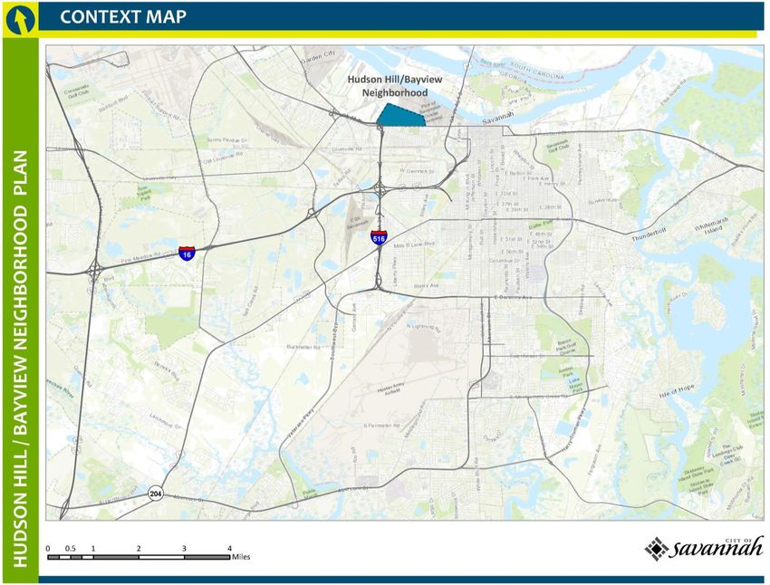
TABLE OF CONTENTS
EXECUTIVE SUMMARY
  Plan Summary............................................................................................................................................................................................................. 1
  Document Overview .................................................................................................................................................................................................. 1
  Neighborhood Vision and Goals ................................................................................................................................................................................ 1
OVERVIEW AND BACKGROUND
 Purpose of the Plan................................................................................................................................................................................................... 3
 Planning Process ....................................................................................................................................................................................................... 3
 Neighborhood Location and Plan Area Context ..................................................................................................................................................... 5
 Historical Overview ................................................................................................................................................................................................... 7
EXISTING CONDITIONS
  Demographic Profile ................................................................................................................................................................................................ 10
  Land Use and Zoning ............................................................................................................................................................................................... 15
  Housing and Property Conditions ...........................................................................................................................................................................22
  Public Safety ............................................................................................................................................................................................................ 26
  Transportation and Mobility................................................................................................................................................................................... 29
  Local Economy ........................................................................................................................................................................................................ 33
  Environment, Health, Recreation and Open Space .............................................................................................................................................. 34
NEIGHBORHOOD ASSETS, CHALLENGES AND OPPORTUNITIES ........................................................................................................................... 38
ACTION PLAN
  Neighborhood Vision, Goals and Objectives ......................................................................................................................................................... 43
IMPLEMENTATION PLAN
  Land Use and Zoning .............................................................................................................................................................................................. 46
  Public Safety ............................................................................................................................................................................................................ 50
  Housing and Property Maintenance ....................................................................................................................................................................... 51
  Economic Development ......................................................................................................................................................................................... 52
  Environment and Health......................................................................................................................................................................................... 54
  Recreation and Open Space ................................................................................................................................................................................... 56
APPENDIX
  Future Land Use Categories.................................................................................................................................................................................... 58
  Current and Proposed Zoning Districts ..................................................................................................................................................................61

                                                                                                                                                                                                                           ii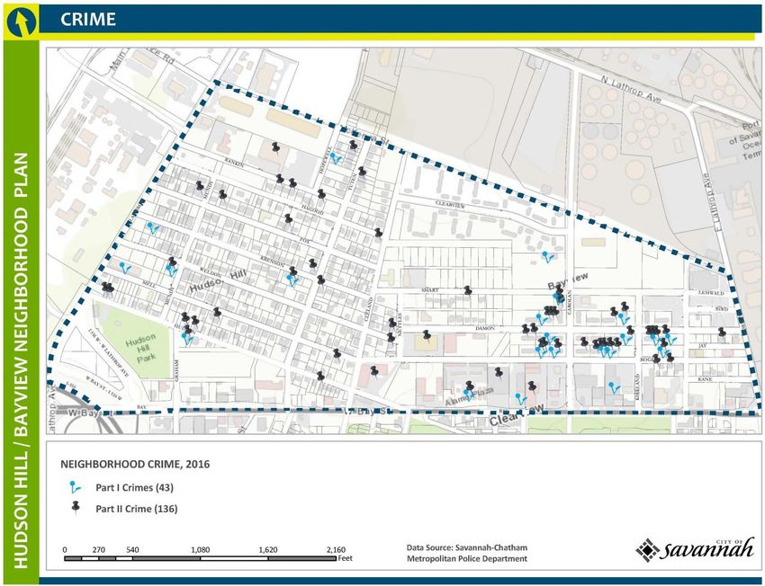
EXECUTIVE SUMMARY
Plan Summary timeframes for implementing the plan upon City Council adoption.
Responsible parties and potential partners listed next to the
Hudson Hill/Bayview is located one mile west of downtown strategies have expressed an interest in assisting with the
Savannah. The Hudson Hill/Bayview Neighborhood Plan area is implementation of this plan and are presumed to be participating
bounded by West Bay Street on the south, Savannah’s municipal as part of their regular work program or in a volunteer capacity.
boundary on the north, East Lathrop Avenue on the east, and West The listed organizations are not presumed to be entities that the
Lathrop Avenue on the west. The plan area boundary encompasses City will contract with to carry out plan implementation activities.
two distinct areas divided generally by Nettles Street and a portion Where needed, cost estimates should be developed as the plan is
of Cleland Street: Hudson Hill, an established single-family implemented to best reflect current conditions. The adoption of
residential neighborhood, occupies the western portion of the this plan does not guarantee or commit future City funds and
community; the Bayview and Clearview multi-family housing other resources, which must be requested during normal
communities along with commercial and light industrial uses budgetary planning and approval cycles and will compete with all
occupy the majority of the eastern portion. other citywide priorities and needs.
The Hudson Hill/Bayview Neighborhood Plan builds on the
significant work undertaken by neighborhood leaders and
Neighborhood Vision and Goals
residents beginning in the early 2000s. The plan provides a The Hudson Hill/Bayview neighborhood envisions a community
framework for addressing neighborhood needs and aspirations in “where families are safe, healthy and prosperous.” Specific goals
the areas of land use, public safety, housing and property supporting this vision are:
maintenance, economic development, environment and health, A neighborhood of traditional residential character that allows
and open space and recreation. neighborhood supported commercial land uses and is buffered
from incompatible industrial uses.
Document Overview A neighborhood free of crime with safe traffic conditions for
The Hudson Hill/Bayview Neighborhood Plan is organized into four all residents.
sections: Overview and Background, Existing Conditions, Action A neighborhood where homes are safe and in good repair, are
Plan and Implementation Plan. The Overview and Background compatible with existing homes, and affordable for families.
describes the neighborhood planning process and the Hudson
A neighborhood that offers economic opportunities for
Hill/Bayview community. The Existing Conditions report looks at
residents of all ages, increases self-sufficiency, builds local
demographic and socio-economic data, property conditions,
wealth, and provides for the commercial needs of residents.
neighborhood crime, current land use and zoning, other data
relevant to the completion of the plan, and a summary of A neighborhood where residents live in a clean, safe, eco-
neighborhood assets, challenges and opportunities. The Action friendly and hazard-free environment.
Plan was resident-driven with input from City staff on developing A neighborhood that offers quality facilities, programs and
achievable goals and objectives. The Implementation Plan outlines outdoor spaces for residents of all ages to participate in active
strategies, responsible parties and potential partners, and and passive recreational activities.
1 HUDSON HILL/BAYVIEW NEIGHBORHOOD PLAN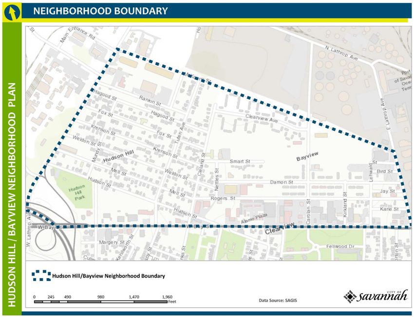
Figure 1:
Context Map

              EXECUTIVE SUMMARY   2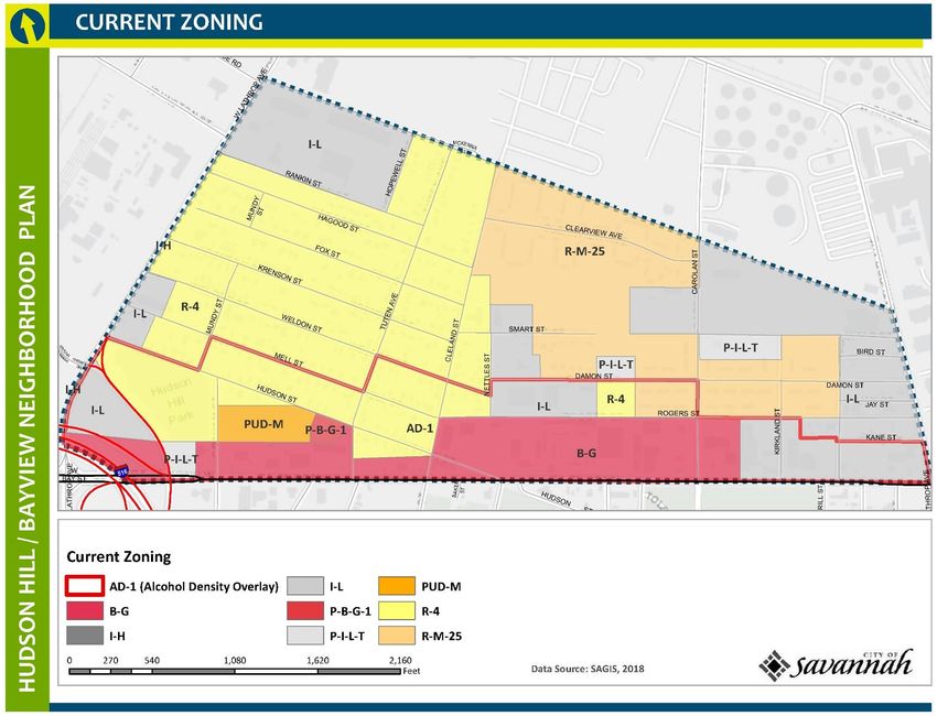
1. OVERVIEW AND BACKGROUND
Purpose of the Plan
The purpose of this plan is to serve as a guide for future                educational trainings, planning charrettes, surveys, and community
development, neighborhood improvements, and capacity building             partnership meetings. The assets, challenges and opportunities
within the Hudson Hill/Bayview community. The plan is rooted in           identified through these various efforts helped to shape the
the community and sets forth an implementation plan that builds           neighborhood’s vision and goals.
upon a shared vision of a neighborhood “where families are safe,
healthy and prosperous.” It provides a framework for addressing           After a five-year break, the Hudson Hill/Bayview neighborhood
neighborhood needs and aspirations in the areas of land use, public       planning process was reinitiated in the spring of 2017. Over a six-
safety, housing and property maintenance, economic and                    month period beginning in April 2017, CPD staff updated the
workforce development, environment and health, and open space             existing conditions analysis and facilitated bi-weekly meetings of a
and recreation.                                                           planning committee established by the community organization.
                                                                          With assistance from various City departments, Metropolitan
It is important to note that this plan is not intended to be a physical   Planning Commission staff, Harambee House, Ivory Bay Community
master plan for the neighborhood, and that more intensive work is         Development Corporation, and Hudson Hill Community Business
needed to help shape future development and preserve and                  Roundtable members, the planning committee revisited and
enhance existing neighborhood assets.                                     finalized the plan goals, objectives and strategies. The resulting
                                                                          action plan establishes measurable objectives to address the needs
Planning Process                                                          identified by the community, and the implementation plan
                                                                          enumerates the strategies that will be carried out to achieve the
The Hudson Hill/Bayview Neighborhood Plan builds on the
                                                                          plan goals and objectives. The plan is intended to be accomplished
significant work undertaken by neighborhood leaders and
                                                                          over a five-year period after plan adoption. Based on the approval
residents beginning in the early 2000’s through their participation
                                                                          of funding and other resources, plan implementation schedules
in the Metropolitan Planning Commission’s West Savannah Land
                                                                          may be adjusted accordingly.
Use and Zoning Study for the Neighborhoods of Hudson Hill, West
Savannah, and Woodville, and the Brickyard Community (2004);
participation in the West Savannah Revitalization Plan (2004-2005);
partnership with The Harambee House, Inc./Citizens for
Environmental Justice in a collaborative effort to build community
capacity, citizen engagement and sustainable environmental
change (2004-present); and engagement with the City of
Savannah’s Community Planning and Development Department
(CPD) in 2010-2011 to capture the earlier body of work and develop
an action plan. Throughout this period, community input was
gained through public dialogue, advisory committee meetings,

 3           HUDSON HILL/BAYVIEW NEIGHBORHOOD PLAN
Visioning
During the planning process, neighborhood residents participated in a charrette where they explored design solutions for
addressing priority issues and developed a clear vision for future development.

                                                                                        OVERVIEW AND BACKGROUND            4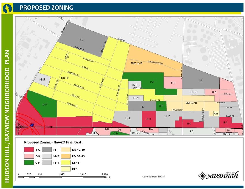
Neighborhood Location and Plan Area Context
Hudson Hill/Bayview is located about a mile west of Savannah’s
historic district. With West Bay Street to the south and industrial
neighbors surrounding it on the east, west and north, this historic
community is easy to overlook. The Savannah River lies just to the
north, and the iconic Talmadge Bridge,1 which carries traffic across
the river into the South Carolina low country, is a short half mile
away.

As shown in Figure 3, the plan area is bounded by West Bay Street
on the south, Savannah’s municipal boundary on the north, East
Lathrop Avenue on the east, and West Lathrop Avenue on the
west. Covering a total of .35 square miles, or 222 acres, the plan
area boundary encompasses two distinct areas: Hudson Hill
occupies the higher ground from West Lathrop Avenue to Nettles
Street and along Smart Street, and is predominantly single-family
residential in nature—with an almost suburban feel based on
population density and development style. The area east of Nettles
                                                                                       Figure 2
Street and a portion of Cleland Street to East Lathrop Avenue is
occupied primarily by the Bayview and Clearview multi-family                           This aerial image shows the close proximity of Hudson Hill/Bayview ( ) to
                                                                                       downtown Savannah, the Savannah River, Hutchinson Island, and the bridge
housing communities as well as numerous commercial and light                           that crosses into South Carolina. It is also a striking reminder of the industrial
industrial uses. West Bay Street, which forms the plan area’s                          envelope that surrounds this residential community and the careful
southern boundary, is a commercial corridor and major gateway                          consideration needed to preserve the community’s heritage and protect its
into downtown Savannah.                                                                residents. (Photo: Google Earth)

1                                                                                   Savannah Bridge, citing that the bridge was named for a 1930s-era segregationist
 In September 2017, the Savannah City Council passed a resolution requesting that
the state legislature change the name of the Talmadge Memorial Bridge to the        governor who is not a “reflection of modern Georgia.”

    5          HUDSON HILL/BAYVIEW NEIGHBORHOOD PLAN
Figure 3:
Neighborhood
Boundary Map

               OVERVIEW AND BACKGROUND   6
Historical Overview2
The lands that the Hudson Hill/Bayview community were built upon Some residents of Jasperville in Hudson Hill established Friendship
once belonged to a Yamacraw Indian village. Tomochichi, the Baptist Church in 1895. Reverend A. Hudson was the first pastor,
village chief, granted land on a high bluff east of the village to serving for thirteen years. He was a major figure in the community,
James Edward Oglethorpe and the British Crown in 1733 to and people named the area “Hudson Hill” in his honor. The church
establish the colony of Savannah. It was not until after has grown and still maintains its presence in the neighborhood.
Tomochichi’s death in 1739, when the local Yamacraw moved off
to other villages, that the colonists gained control of the lowlands In the early decades of the twentieth century, Hudson Hill was still
west of Savannah. Much of these lands became in the 1750s the rural in nature, although developers were beginning to establish
1,000-acre Royal Vale Plantation, which was bounded by the subdivisions. Some housing was provided by companies such as
Savannah River to the north; Fahm Street and what is now West Union Bag and Paper Corporation, which opened a plant in the area
Lathrop Avenue to the east and west respectively; and Augusta in 1936, and the Adeline Sugar Company (Dixie Crystals), which
Avenue to the south. After slavery, this rice plantation was moved to the area from Louisiana in 1916, bringing a large number
replaced with small municipal farms and subsequently became of relocated employees with it, and opened the Savannah Sugar
what is now the Hudson Hill and West Savannah neighborhoods. Refinery in 1917. Workers for these and other companies by-passed
the already-crowded Yamacraw area and settled in Hudson Hill.
In 1890, the Jasperville Land Settlement Company began selling
lots on the western side of Hudson Hill. Many of the streets that
were laid out, including Fox, Krenson, Weldon and Mell, still bear
these names today. The lots were advertised as being on high
ground with good drainage and near riverfront industries and
wharves. Hardworking sharecroppers managed to purchase lots
and build homes, and many descendants of Hudson Hill’s founders
still occupy the neighborhood. By 1916, there was more
development and streets (usually only one block long) on both the
eastern and western portions of Hudson Hill. A central tract of land
owned by William J. Exley remained vacant well into the 1930s. As
a result, this area of Hudson Hill developed much later than the rest
of the neighborhood.
2 Neighborhoods” by Martha L. Keber as well as recollections of community
Historical information about Hudson Hill/Bayview is from “Low Land and the High
Road: Life and Community in the Hudson Hill, West Savannah, and Woodville residents.
7 HUDSON HILL/BAYVIEW NEIGHBORHOOD PLANFollowing annexation by the City of Savannah in 1939, Hudson Hill The Bayview Homes subdivision was laid out in 1942 to provide
expanded as a neighborhood in the 1940s and 1950s. The street housing for World War II era shipyard workers. Twenty-six of these
network was one-story, quadplex homes are clustered between Rogers Street
laid out in a grid and an extension of Smart Street, from Lehwald Street on the east
pattern, and to just west of Carolan Street.
most houses in
Similarly, the 15-
Hudson Hill
acre Clearview
were small and
Homes apartment
one-story. The
complex, located
majority were
between Cleland
shotgun houses
Street and Carolan
(one room wide
Street on the
and one or more
neighborhood’s
rooms deep,
northern edge, was
lined up one
developed in the
behind the other
early 1940s as
with no hallway). Jasperville and adjacent properties, 1940.
housing for war
Craftsman-style homes
workers. Today,
became widespread in both Hudson Hill and West Savannah in the
these multi-family
early 20th century.
housing
developments
1920s shotgun provide affordable
style house on housing for low
Hudson Street. income workers,
many of them Bayview Homes and Clearview Homes,
transient. Sanborn Map Company, 1954
Throughout the century, many of the original small homes in
Hudson Hill were enlarged by additions and newer homes were
built larger than earlier ones. By 2000, Hudson Hill led the west
Savannah area in larger homes, with five to seven rooms per
dwelling. Electricity was common in homes by mid-century, and
OVERVIEW AND BACKGROUND 8gas replaced wood- and/or coal-heat in the 1950s. Modern In addition to the nearby presence of major businesses and
plumbing and sewer access was not as quickly available. Most employers, such as the Port of Savannah, Hudson Hill during most
Hudson Hill homes had indoor plumbing by 1970. of the 20th century had a number of small, neighborhood-based
family-run businesses such as food shops, gas stations, barber
The development of paved roads and sidewalks also proceeded shops, restaurants, beauty shops, and laundromats. There were
slowly. Despite annexation into the City of Savannah in 1939, there both black-owned and white-owned establishments.
were unpaved roads remaining until the early 1980s. The street
network in Hudson Hill is laid out in a grid pattern, with short blocks Over the next decades, the loss of private investment in the
running north to south and longer (in some cases, very long) blocks community coupled with the sporadic spread of municipal services
running east to west. following annexation4 helped to position this low wealth
community for decline. As integration and the Civil Rights
The main commercial corridor in the neighborhood is West Bay Movement progressed and car ownership increased, the number
Street. The neighborhood shares this corridor with the of local businesses decreased. White business owners living in the
neighborhood to the south, West Savannah. The buildings along neighborhood sold or relocated their businesses. Neighborhood
West Bay are older commercial buildings from the latter half of the residents increasingly chose to take their purchasing power
20th Century (although many of these buildings are undergoing elsewhere. Many small businesses stand empty today or have
changes as major road and streetscape improvements are being disappeared altogether.
made to the corridor). A motor inn and heavier commercial
properties are also located along the corridor. At the same time, the number of manufacturing and other jobs
(the port and especially the railroads) that first attracted residents
The character of Hudson Hill remained largely rural well through to Hudson Hill dropped as the economy changed. The number of
the 1950s, where many if not all residents maintained vegetable lesser-paying service jobs rose. Unemployment rose and the
gardens. In the early 20th century, there were some hog pens and neighborhood deteriorated.
chicken coops in the neighborhood. Current residents recall the
gardens that were a staple of residents' yards as well as Still, the neighborhood is anchored by a strong core of longtime
“the surrounding wilds of pecan trees, blackberries and residents—some of whom live in homes that have been in the
scuppernong.”3 The gardens and rural nature slowly faded with same family for generations and some of whom chose to build and
time, although many residents retain separate parcels as side make their homes in the community in which they were raised—
yards, giving the area a suburban feel. who continue to work to preserve and improve their community.
During all this time, Hudson Hill was an integrated neighborhood.
Black residents lived primarily on one side of Tuten Street,
white residents on the other. There was a small but significant
percentage of Native Americans as well.
3 City Talk, Savannah Morning News, Aug 8, 2010 4 Keber, p. 123.
9 HUDSON HILL/BAYVIEW NEIGHBORHOOD PLAN2. EXISTING CONDITIONS
Demographic Profile Table 1: Hudson Hill/Bayview Demographic Summary
Hudson Hill/
The Hudson Hill/Bayview neighborhood encompasses two distinct
Population, 2015 Bayview City of Savannah
areas that, while different in character, share many demographic
similarities. Hudson Hill itself lies in the western half of the Total Population 1,298 142,919
neighborhood and is composed of an almost suburban feel based Population /Acre 5.8
on population density and development style. The Bayview and
Clearview areas in the eastern half of the neighborhood are largely Male 46% 48%
made up of four-unit apartment buildings, with a fairly transient Female 54% 52%
population, and commercial and light industrial uses. Black / African American 77% 54%
5
Hudson Hill/Bayview is home to an estimated 1,298 people, White 11% 40%
showing a 4% decline since 2010. At roughly 3,700 people per Other 12% 7%
square mile, Hudson Hill/Bayview’s population density is
approximately a third of that of many traditional in-town Hispanic (of any race) 20% 5%
neighborhoods such as Cuyler-Brownville and almost half the Median Age 27 31.4
density of the West Savannah neighborhood just to the south. Dominant Age group 17 & Under 25 to 34 Years
Hudson Hill/Bayview is a predominantly African American ACS, 2011 - 2015 Five Year Estimates
community with an estimated 76.8% of residents counted as
Black/African American. Whites make up 11.3% of the population,
and other races account for 11.9%. People with Hispanic origins (of
any race) make up 20% of the neighborhood’s population,
compared with only five percent citywide.
Young people (17 and under) make up the largest age group in Hudson Hill/ Bayview.
5 Alldemographic, educational attainment, income, employment and poverty data Year Estimates. Hudson Hill/Bayview falls within Block Group 2, Census Tract 116,
is from the U.S. Census Bureau, American Community Survey (ACS), 2011-2015 Five Chatham County, Georgia. Percentages may not add up to 100% due to rounding.
EXISTING CONDITIONS 10Age and Gender—Young people represent a promising asset for number indicates there is a potentially strong market for
the neighborhood, and their numbers have grown consistently workforce development and entrepreneurial training efforts and
over the years except for a slight decline in 2010. Hudson hiring locally as jobs are created.
Hill/Bayview has a younger population than the city at large, with a
median age of 27 compared with 31.4 citywide. Also, whereas 25- Compared with the city as a whole, women make up a slightly
34 is the dominant age group in Savannah, youths (17 and under) higher percentage of the neighborhood’s population at 54%,
make up the largest age group in Hudson Hill/Bayview. compared with 52.5% women citywide. Among Hudson Hill/
Bayview’s working age population (25-64), women outnumber
The second major age group in the neighborhood is 25–34, and this men by more than 37%. Women are also more likely to be counted
age group has increased as a percentage of the total population as the householder (the person in whose name the housing unit is
since 2000. Residents considered to be in their prime working owned or rented) in family households than men—accounting for
years (age 25-54) account for 38.3% of the neighborhood’s 75% of householders in the neighborhood.
population, just under the citywide total of 39.4%. This strong
Figure 4: Age Trend, Hudson Hill/Bayview, 2000 – 2015 Table 2: Population by Age and Sex, 2015
Male 598 46.0%
40%
17 & Under 237 18.3%
35% 18-24 75 5.8%
25-34 115 8.9%
30% 2000
35-49 60 4.6%
2010
25% 50-64 41 3.2%
2015 65-74 44 3.4%
20% 75+ 25 1.9%
15% Female 700 54.0%
17 & Under 236 18.2%
10% 18-24 49 3.8%
5% 25-34 156 12.0%
35-49 92 7.1%
0% 50-64 96 7.4%
17 & 18-24 25-34 35-49 50-64 65-74 75+
65-74 31 2.4%
Under
75+ 39 3.0%
U.S. Census Bureau (2000 and 2010); ACS 2011-2015 Five Year Estimates (2015) ACS, 2011-2015 Five Year Estimates
11 HUDSON HILL/BAYVIEW NEIGHBORHOOD PLANEducational Attainment—Hudson Hill/ Bayview lags behind the Figure 6: Educational Attainment by Gender, Hudson Hill/Bayview
city as a whole in educational attainment. Among Hudson Hill/
Bayview residents 25 years and older, 61% are high school
graduates or higher, compared with 86% citywide. Almost 40% have 3%
Female
less than a high school education, compared with 14% citywide. 81% Bachelor's Degree or
Higher
Only two percent of residents hold bachelor’s degrees or higher
High School
(all held by women), compared with 28% for the city. Overall, Male Graduate or Higher
31%
women have significantly higher educational attainment levels
than men. According to longtime community members, many
Hudson Hill residents matriculate through the local school system; 0% 50% 100%
however, in pursuit of better economic conditions, there has been ACS, 2011-2015 Five Year Estimates
a trending exodus of young scholars to areas offering better
opportunities. Table 3: Educational Attainment, Population 25 Years and Older,
Hudson Hill/Bayview and City of Savannah Comparison
Figure 5: Educational Attainment, Population 25 and Older
Hudson Hill/ City of
12th Grade or Less, No diploma Bayview Savannah
(39%) 12th Grade or Less, No diploma 39% 14%
High School Diploma (35%)
High School Graduate or Equivalent 35% 28%
Some college, No degree (14%) Some college, No degree 14% 24%
Associate's Degree (10%) Associate's Degree 10% 6%
Bachelor's Degree 1% 17%
Bachelor's Degree (1%)
Graduate or Professional Degree 1% 11%
Graduate or Professional ACS, 2011-2015 Five Year Estimates
Degree (1%)
ACS, 2011-2015 Five Year Estimates
EXISTING CONDITIONS 12Income and Employment—Economic and social stability are key Low and moderate income households (those at or below 80% of
determinants of health, safety and prosperity in a neighborhood. AMI) make up approximately 74% of households. Figures 7 and 8
Over a third (35%) of Hudson Hill/Bayview residents are living below compare median household income and poverty levels of Hudson
the federal poverty level, compared with 26% citywide. Hill/Bayview with those of the city of Savannah.
Unemployment and unaffordable housing are closely linked to
Figure 7: Low and Moderate Income Households
poverty. One in seven residents age 16 and older is unemployed,
(Households making 80% or less than the Area Median Income)
and almost half of homeowners (46%) and renters (47%) are
housing cost burdened, meaning they spend more than 30% of
their income on housing and may have difficulty affording food,
transportation, medical care and other necessities.6 City of
Households ≤ 80% 54%
Savannah
Table 4: Households and Income AMI (Moderate
Income) 74% Hudson
Hudson Hill/ City of Hill/Bayview
Bayview Savannah
Total Households 427 52,798
Median Household Income 23,289 36,466 0% 50% 100%
Persons in Poverty 35% 26% ACS, 2011-2015 Five Year Estimates
Cost Burdened (30%+ Owners) 46% 26% Figure 8: Percentage of Population below the Poverty Level
Cost Burdened (30%+ Renters) 47% 48%
ACS, 2011-2015 Five Year Estimates
City of Savannah 26%
The 2015 median household income in Hudson Hill/Bayview was
$23,289, compared with $36,466 in Savannah. Low income
households (households earning 50% or below the area median Hudson Hill/Bayview 35%
income, or AMI7) account for more than half (approximately 53%)
of Hudson Hill/Bayview households. 0% 10% 20% 30% 40%
ACS, 2011-2015 Five Year Estimates
6 The U.S. Department of Housing and Urban Development defines cost-burdened 7 Area Median Income (AMI) is based on the Savannah MSA median household
families as those “who pay more than 30 percent of their income for housing” and income of $50,618.
“may have difficulty affording necessities such as food, clothing, transportation,
and medical care.”
13 HUDSON HILL/BAYVIEW NEIGHBORHOOD PLANTwo-thirds of Hudson Hill/Bayview’s population 16 years and older Table 6: Employment by Industry
is in the labor force. Of this population, 86% is employed and 14% is Industry Type % of Population
unemployed.
Transportation and Warehousing, and Utilities 20%
Table 5: Employment Status, Population 16 Years and Over
Professional and Related Services 18%
Hudson Hill/ % of
Bayview Neighborhood Accommodation and Food Services 13%
Population 16 Years and Over 842 Construction 11%
Civilian labor force: 554 66% Education, Health Care and Social Assistance 9%
Employed 477 86%
Retail and Trade 8%
Unemployed 77 14%
ACS, 2011-2015 Five Year Estimates
Armed Forces 0 0%
Not in labor force 289 34%
Figure 9: Occupation for the Civilian Employed
ACS, 2011-2015 Five Year Estimates
Production, transportation, and 29%
Most employed Hudson Hill/Bayview residents work in production material moving occupations 49%
and service occupations, with the highest percentage employed in
Natural resources, construction, 0%
the transportation and warehousing industries. As shown in Figure
and maintenance occupations 21%
9, the top occupations among Hudson Hill/Bayview male residents
are production, transportation and material moving (49%) and 35%
Sales and office occupations
construction (21%). Hudson Hill/Bayview female residents work 4%
primarily in sales and office occupations (35%), production, 29%
Service occupations
transportation and material moving (29%), and service occupations 15%
(29%). An estimated 20% of Hudson Hill/Bayview residents are Management, business, science, 8%
employed in transportation/ warehousing and utilities industries, and arts occupations 10%
while 18% work in professional and related service industries and
13% work in the accommodation and food services industry 0% 10% 20% 30% 40% 50% 60%
(see Table 6). % of Women % of Men
ACS, 2011-2015 Five Year Estimates
EXISTING CONDITIONS 14Land Use and Zoning
Table 7: Land Use by Category
Existing Land Use Patterns
Land Use Count Percent
All general land use categories—commercial, industrial and
Commercial 32 6%
residential—are found in Hudson Hill/Bayview. Single family
residential uses predominate west of Nettles Street and along Industrial 20 4%
Smart Street, and multi-family residential uses occupy much of the Institutional 9 2%
land east of Nettles Street and a portion of Cleland Street, as Residential 328 57%
shown in Figure 10, Existing Land Use. Most of the commercial uses Undeveloped Lot (Including Parks) 176 31%
are found along West Bay Street, which serves as the main Total 566 100%
commercial corridor for Hudson Hill/Bayview and the West SAGIS 2015 Parcels
Savannah neighborhood to the south. Industrial uses are found
Table 8: Land Use by Parcel
along West Lathrop Avenue and Rankin Street, and on scattered
sites east of Nettles Street. Heavy industry surrounds the Land Use (Specific) Count Percent
neighborhood immediately to the west, north and east on lands Commercial: General Business 21 3.7%
located in a constitutionally created “industrial area” within Industrial: Heavy (I2) 4 0.7%
unincorporated Chatham County.8 Industrial: Light (I1) 5 0.9%
By category, residential uses make up the largest percentage of Institutional: Association 1 0.2%
land uses, at 58%. Commercial and industrial uses account for 6% Institutional: Religious 8 1.4%
and 4% of land uses, respectively. In addition to these developed Residential: Duplex 14 2.5%
lands, Hudson Hill/Bayview has numerous undeveloped lots, which Residential: Multi-family 25 4.4%
account for about 30% of the land area in the neighborhood. These Residential: Single-family detached 298 52.7%
lots range from lots used for stormwater management purposes
Undeveloped Lot: Parks/Recreation 2 0.4%
by the City of Savannah to vacant, overgrown lots. Some of the
Undeveloped Lot: Side yard 14 2.5%
undeveloped lots are used as side yards by neighboring residential
properties, and others include FEMA properties, community Undeveloped Lot: Vacant lot 153 28.1%
garden lots, and properties serving utility purposes. 9 Utility/Other 21 3.7%
Total 566 100.0%
SAGIS 2015 Parcels
8 Industrial Areas were created by multiple amendments to the Georgia have been subject to repeated flooding. Partial funding for property acquisition is
Constitution beginning in 1950. provided through the Federal Emergency Management Agency’s Hazard Mitigation
9 FEMA properties are flood-prone properties purchased by local governments Grant Program.
through voluntary buyout programs offered to homeowners in neighborhoods that
15 HUDSON HILL/BAYVIEW NEIGHBORHOOD PLANFigure 10:
Existing
Land Use
EXISTING CONDITIONS 16Long-standing Land Use and Zoning Issues Hudson Hill/Bayview has faced long-standing issues posed by the
adjacency of industrial and heavy commercial uses and zoning
In February 2004, the Savannah City Council requested that the classifications to single and multifamily residential uses (see
Metropolitan Planning Commission conduct a land use and zoning sidebar). A review of existing land use patterns and zoning districts
study for West Savannah, Hudson Hill, Woodville, and the conducted as part of this planning process also reveals pockets of
Brickyard Community. A Westside Neighborhood Advisory incompatible zoning and land uses within the boundaries of the
Committee was appointed by the MPC and held its first meeting plan area. The lack of adequate buffers is a major concern for
on April 19, 2004. Monthly meetings were held to identify issues residents in some of these areas. There is also a desire on the part
and opportunities in the community, to develop land use and of the community to establish boundaries delineating areas where
zoning goals, and to integrate those goals with the city’s commercial growth is desired while appropriately protecting
economic development and housing programs. In September existing residences.
2004, the MPC produced a draft zoning study, West Savannah
Land Use and Zoning Study for the Neighborhoods of Hudson Hill, A review of the neighborhood conducted during the countywide
West Savannah, and Woodville, and the Brickyard Community. zoning assessment associated with the New Zoning Ordinance
(NewZO) resulted in a number of proposed changes to the City’s
Before any action could be taken on the study, City Council zoning map to address concerns stemming from incompatible land
commissioned Goody-Clancy and Associates to produce uses. The intent of the proposed changes is to reduce the impact
a redevelopment plan for the West Savannah Neighborhood. of industrial and commercial uses by rezoning to less intensive
The Westside Rezoning Study was placed on hold categories, and to properly zone residential districts so that they
pending completion of the West Savannah Neighborhood would have the opportunity to be redeveloped while maintaining
Redevelopment Plan. The Plan was completed in 2005, and the desired development pattern.
the rezonings in the West Savannah neighborhood associated
with the Plan were approved by the Savannah City Council in Current Zoning
April 2007. As shown in Figure 11, the current zoning districts in Hudson
Hill/Bayview include R-4 four-family residential, R-M-25 Multifamily
Members of the affected neighborhood associations, including Residential, B-G General-Business, P-B-G-1 Planned General
the Hudson Hill Community Organization, requested that the MPC Business Transition, I-L Light-Industrial, and P-I-L-T Planned-Light-
proceed with the rezoning on a neighborhood by neighborhood Industrial-Transition. The Hudson Hill/Bayview area is also covered
basis in order to correct the most pressing zoning problems. by an Alcohol Density Overlay District, adopted by City Council in
Although some work to address zoning issues in Hudson January 2019 with the intent of limiting the sale and serving of
Hill/Bayview was conducted as part of the City’s zoning ordinance alcoholic beverages in an effort to address the negative impacts of
update (NewZO) and is reflected on the proposed zoning map, these uses at certain locations in the city.
additional action will be needed to fully align zoning districts with
neighborhood land use goals. The overlay establishes use conditions and/or prohibitions for
various uses, including assembly halls, event venues, principal use
17 HUDSON HILL/BAYVIEW NEIGHBORHOOD PLANcocktail lounges, bars, taverns, nightclubs, adult entertainment To address these concerns and ensure that the City’s land use and
establishments, package stores, restaurants, and ancillary retail zoning regulatory framework support neighborhood goals, the
package sales. (See Article O, Section 8-3355 of the City’s Zoning plan sets out recommendations to modify future land use
Ordinance for specific use conditions and prohibitions; similar designations; assess public improvement needs to encourage
language will be included in the NewZO.) neighborhood scale development and connectivity; and align
neighborhood zoning districts with desired land use patterns.
An Alcohol Density (“AD”) District is identified on the City’s official
zoning map as “AD” followed by a designated number). The Land use and zoning recommendations are discussed in detail in
numerical designation identifies the geographic location of the the Implementation Plan section of this document.
overlay district. The Hudson Hill/Bayview area falls under AD-1, as
shown in Figure 12. Single family
homes facing
NewZO poorly screened
A review of the neighborhood conducted during the countywide industrial
zoning assessment associated with the New Zoning Ordinance properties on
Damon Street.
(NewZO) resulted in a number of proposed changes to the City’s
zoning map to address concerns stemming from incompatible land
uses. The intent of the proposed changes is to reduce the impact
of industrial and commercial uses by rezoning to less intensive
categories, and to properly zone residential districts so that they
would have the opportunity to be redeveloped while maintaining
the desired development pattern. Industrial and heavy
commercial uses
The proposed zoning categories in the current NewZO draft are surround the
shown in Figure 13. The most significant changes are the expansion neighborhood’s
single family and
and reduction in intensity of the single family residential district;
multifamily
the shift from General Business to Community Business along West residential areas,
Bay Street; the change to Neighborhood Business in areas and pockets of
currently zoned Light Industrial; the introduction of the Light incompatible zoning
Industrial-Restricted and Light Industrial-Transition categories to and land uses exist
throughout the plan
encourage less intensive uses than allowed under in current Light area.
Industrial districts. Table 16, in the Appendix provides descriptions
and a side-by-side comparison of current and proposed zoning
districts.
EXISTING CONDITIONS 18Figure 11: Current Zoning Zoning District definitions are provided in the Appendix. 19 HUDSON HILL/BAYVIEW NEIGHBORHOOD PLAN
Figure 12:
Alcohol Density
Overlay District
(AD-1)
This district includes
portions of the
Hudson Hill/Bayview,
West Savannah,
Woodville/Bartow,
and Bay Street
Viaduct Area
neighborhoods.

                         EXISTING CONDITIONS   20
Figure 13:
Proposed Zoning --
New ZO Final Draft,
February 2019
Zoning District
definitions are
provided in the
Appendix.
Chatham County-Savannah Metropolitan Planning Commission (http://www.newzo.org/)
21 HUDSON HILL/BAYVIEW NEIGHBORHOOD PLANHousing and Property Conditions
Housing Figure 14: Housing Occupancy, Hudson Hill/Bayview
As discussed earlier, the plan area encompasses two distinct
areas—Hudson Hill, which is predominantly single-family
residential in nature with some duplexes on scattered sites. 21%
Housing east of Nettles Street and a portion of Cleland Street is
predominately multi-family. Overall, the plan area has an estimated
544 housing units, 79% of which are occupied. Vacant Units
Hudson Hill/Bayview’s housing vacancy rate of 21% is almost Occupied Units
5% higher than that of the city. Of the neighborhood’s occupied
housing units, 32% are owner-occupied and 68% are renter- 79%
occupied. This compares with a citywide owner-occupied rate of
44% and renter-occupied rate of 56%. The rate of homeownership
in Hudson Hill Bayview has declined steadily since 2000, as shown
in Figure 15. Along the neighborhood’s western edge blocks alone, ACS, 2011-2015 Five-Year Estimates
fifteen properties are corporately-owned. The median home value
of owned homes is $88,200, almost 40% lower than the median Figure 15: Occupied Housing by Tenure, 2000-2015
value citywide. 80%
Table 9: Housing Occupancy and Tenure 70% 68%
Hudson Hill/ City of 60% 58% 59%
Bayview Savannah
50% Owner
Total Households 427 52,798 42% 41% Occupied
40%
Total Housing Units 544 62,335
30% 32% Renter
Vacancy Rate 21% 15.3%
Occupied
Owner Occupied Units 32% 44% 20%
Renter Occupied Units 68% 56% 10%
Median Value of Owned Homes $88,200 $142,000 0%
ACS, 2011-2015 Five-Year Estimates 2000 2010 2015
U.S. Census Bureau (2000 and 2010); ACS 2011-2015 Five Year Estimates (2015)
EXISTING CONDITIONS 22Two-thirds of the housing units in Hudson Hill/Bayview were built Figure 16: Age of Housing by Year Built
before 1970, with the most active period from 1940-1949. About
half of all renters in Hudson Hill/Bayview live in units that are 1939 or earlier 23
almost 70 years old or older. Older housing, whether owned or 1940-1949 193
rented, requires continual reinvestment to keep it from becoming 1950-1959 58
functionally obsolete or degraded due to deferred maintenance.
1960-1969 82
Older housing stock can also present health and safety hazards to
1970-1979 42
occupants from hazardous materials such as lead-based paint,
asbestos and carbon monoxide. Elderly home owners in older 1980-1989 85
housing stock often have deferred maintenance and obsolete 1990-1999 0
mechanical systems that can burden occupants with high utility 2000-2009 56
bills or health and safety issues. These higher operational costs can 2010 or later 1
also burden households with otherwise affordable rent or
mortgages. 0 50 100 150 200
New housing stock was added between 2000 and 2009, ACS, 2011-2015 Five-Year Estimates
accounting for 10% of the neighborhood’s housing units. Of these
newer units, roughly 60% are owner-occupied—a promising trend.
With the exception of one single family home built in 2016 by
Habitat for Humanity, there has been no new home construction
since 2010. Building permit records indicate a modest amount of
renovation activity in the neighborhood over the past three years,
with seven building permits issued between 2014 and 2017.
Housing trends overall, however, point to a need for both
reinvestment and continued new investment in the neighborhood.
23 HUDSON HILL/BAYVIEW NEIGHBORHOOD PLANProperty Conditions
The condition of properties within Hudson Hill/Bayview varies from Table 10: One- and Two-Unit Residential Housing Quality Based on
good to very poor. Properties in poor condition contribute to Improvement Value of Structure
deteriorated living conditions on some sections of the Property Percent of Physical
neighborhood. Condition Count Total Depreciation
Good 48 17% 15%
A property conditions survey conducted by City staff in 2010
Standard 64 22% 30%
showed that the majority of properties (71%) were in standard
Fair 69 24% 45%
condition or had only minor problems. Almost 20% of properties
had moderate problems, and the remaining 10% were rated as Poor 69 24% 60%
having major problems. Major problems were observed primarily Very Poor 38 13% >75%
in the Bayview Homes and commercial areas, but also on scattered Total Count 288 100% 100%
lots throughout the Hudson Hill single family residential area.10 SAGIS 2015 Parcels
A 2017 update of the survey showed that some properties had
improved while others declined in condition since 2010. Overall, Property Maintenance Complaints—Hudson Hill/Bayview has
however, the percentages of properties with standard, minor, numerous undeveloped lots, which account for 28% of the land
moderate and major problems remained consistent. area in the neighborhood. Open space is an asset and directly
contributes to the community’s suburban feel. Poorly maintained
Existing Conditions—In terms of residential housing quality, an lots and open spaces, however, can become blighted and place a
analysis conducted by City staff in October 2017 shows that almost heavy burden on the neighborhood when they are allowed to be
40% of single family and duplex units are in standard or good overgrown, collect trash and bulk items, or used for unauthorized
condition based on improvement value. Another 37% are in poor or or illegal activities.
very poor condition, while 24% are in fair condition. The wide
spread in the improvement value of structures is likely an In 2016, there were a total of 110 property maintenance complaints
indication of substantial deferred maintenance. (See Table 10.) in Hudson Hill/Bayview, with the highest number (41) in the
occupied property category, followed by derelict vehicle (33) and
vacant lot/building complaints (22). Over the period from 2011-
2016, vacant lot/building violations declined by 51%, while occupied
property violations increased 46%. Derelict vehicle complaints
were back up to the 2011 level after a decline in the intervening
10The property conditions survey considered building conditions and yard/lot chipped/peeling/failing paint, 25%-50% of siding needing replacement,
cleanliness (litter, growth, bulk items, debris, abandoned autos). Standard=No door/window frames deteriorated, eave replacement needed; Major= Conditions
problems; Minor=Conditions such as dirty/mildewed paint, fence or eave repair such as missing steps; 50% of siding needing replacement.
needed, screens needing replacement; Moderate= Conditions such as
EXISTING CONDITIONS 24years. The lowest number of complaints during this period was in
the unsafe/secure/demolition category, followed by housing code
complaints. The total number of complaints across all categories
remained relatively steady except for a brief decline in 2012.
Table 11 (and Figure 17, below): Property Maintenance Complaints, 2011-2016
Vacant Unsafe /
Derelict Lot/ Secure / Occupied Housing
Vehicle Building Demolition Property Code Total
2011 33 45 3 28 2 111
2012 12 41 8 19 3 83
2013 28 29 8 23 14 102
2014 18 37 6 30 12 103
2015 28 28 2 27 19 104
2016 33 22 4 41 10 110
City of Savannah 311 System, Jan.01, 2011 - Dec. 31, 2014; EnerGov, Jan. 2015 - Dec. 2016
Figure 17
50
45
40
Derelict Vehicle
35
30 Vacant Lot/ Building
25 Unsafe / Secure /
20 Demolition
Occupied Property
15
10 Housing Code
5
0
2011 2012 2013 2014 2015 2016
25 HUDSON HILL/BAYVIEW NEIGHBORHOOD PLANPublic Safety Part I crime in 2016 was somewhat scattered throughout the
neighborhood, although there was some concentration of activity
Neighborhood Crime in the Bayview Homes area. The predominant crime reported was
Longtime residents describe Hudson Hill as a traditionally low larceny with 16 incidents, followed by aggravated assault (11) and
crime area. Low employment rates, the presence of vacant and burglary (8).
abandoned properties and neighborhood decline over the years,
however, can open the door to criminal activity. These conditions The number of Part II crimes in Hudson Hill/Bayview dropped
are more evident in the Bayview area, where incidents of Part I dramatically from 2011 to 2016, from 198 to 25 reported incidents.
crime tend to be more prevalent than in the Hudson Hill The highest number of incidents during this period were reported
neighborhood. According to SCMPD officers, crimes in the in 2011 and 2012, with simple assault as the predominant crime,
neighborhood are generally disconnected in nature with no regular followed by property damage. Over half of the simple assault
pattern, and in many cases, serve as evidence of other crimes incidents in 2011 occurred in the Clearview Homes area; in 2012,
committed elsewhere in the city. most of the simple assaults were reported in the Bayview and West
Bay Street areas.
Overall, there has been a downward trend in the total number of
Part I crimes in Hudson Hill/Bayview since 2011 as shown in As with Part I crimes, Part II crimes during 2016 tended to
Figure 18. In 2016, Part I property crimes were down by over a third be scattered with some clustering in the Bayview area.
from the previous year; violent crimes, however, increased The predominant Part II crimes reported in 2016 (as in earlier years)
significantly with 13 violent crimes in 2016 compared with five in were simple assault, with 35 incidents, and property damage, with
2015.11 31 incidents. Other significant Part II crimes in 2016 were disorderly
conduct followed privacy/trespassing.
Figure 18: Part I Crimes, 2011-2016
Figure 19: Part II Crimes, 2011-2016
100
250
Number of Crimes
80
Number of Crimes
200
60 Violent Crimes
150
40 Property Crimes
100 Part II Crimes
20 Total Part I
50
0
2011 2012 2013 2014 2015 2016 0
2011 2012 2013 2014 2015 2016
11 Part
I Crimes include violent and non-violent criminal activity such as assault, crimes such as drug dealing, drug possession, disorderly conduct, driving under the
homicide and burglary. Part II Crimes include offenses of a lesser nature than Part I influence, firing of weapons, and property damage.
EXISTING CONDITIONS 26Figure 20: Part I and Part II Crime, 2016 27 HUDSON HILL/BAYVIEW NEIGHBORHOOD PLAN
Traffic Safety
During the planning process, residents expressed concerns about
speeding and other traffic violations. A study of various types of
crashes conducted by the City’s Traffic Engineering Department
from August 2014 to August 2017 showed that the most common
type of crashes involved parked cars. A total of 35 parked car
crashes were reported over the three-year period. In addition to
speeding incidents, the neighborhood’s narrow streets and
prevalence of on-street parking throughout the neighborhood are
contributing factors to this type of vehicle collisions. Angle crashes
numbered 13, with repeat incidents occurring at two intersections
(Mell/Mundy Streets and Cleland/Weldon Streets). There were
three bicycle crashes and four pedestrian crashes during the study
period.

                                                                         EXISTING CONDITIONS   28
Transportation and Mobility
Street Network
Hudson Hill/Bayview is served by an urban principal arterial, West West Bay Street Improvements —The portion of West Bay Street
Bay Street (State Route 25 Connector), which forms the forming the neighborhood’s southern boundary is undergoing a
neighborhood’s southern boundary, and two major collectors, West transformation designed to improve vehicular and pedestrian
Lathrop Avenue and East Lathrop Avenue, which form the west safety. This Georgia Department of Transportation (GDOT) project,
and east boundaries, respectively. Interstate 516 (I-516) intersects which extends roughly 1.3 miles from just west of West Lathrop
with West Bay Street at the southwestern edge of the Hudson Hill Avenue to the western end of the Bay Street Viaduct, includes
neighborhood, providing quick access to I-16 and Southside upgrades to traffic signals, relocation of sidewalks a safe distance
Savannah. This section of West Bay Street is a designated Hurricane from the edge of pavement, grass buffer strip, crosswalk
Evacuation Route and school bus route. It also serves as an improvements with new striping and pedestrian signals, additional
important through route for trucks traveling from I-516 to transit stops, and enhancements to the visual aspect of the
commercial and industrial facilities adjacent to and north of West corridor with median and streetscape improvements. On the
Bay Street along the Savannah River. downtown side of the viaduct, the City of Savannah is expanding a
street improvement initiative that will carry Bay Street streetscape
The neighborhood’s internal circulation system is made up of local improvements westward to the eastern base of the viaduct. These
streets and one minor collector, Carolan Street, which serves the two projects will create an important link between Hudson Hill and
Bayview and Clearview developments and commercial other west Savannah neighborhoods to downtown.
establishments on the eastern side of the community and connects
to industrial uses along North Lathrop Avenue. The local street
network is laid out in a grid pattern and has changed very little
since the mid-1950s.
Very few improvements have been made to local streets in recent
years, with the most recent resurfacing occurring in 2003 and 2004
and the installation of two ADA curb ramps at Clearview and
Carolan Streets in 2014. According to the City’s Streets
Maintenance Department, many of Hudson Hill/Bayview’s streets
are in need of resurfacing. A total of 33 street segments received a
rating of higher than 20 in an evaluation conducted by Streets
This section shows median, streetscape, and intersection improvements along
Maintenance in 2013 and 2014, which makes them eligible for West Bay Street between East Lathrop Avenue and Carolan Street. (Image: Georgia
resurfacing under GDOT’s Annual Local Maintenance & Department of Transportation)
Improvement Grant.
29 HUDSON HILL/BAYVIEW NEIGHBORHOOD PLANYou can also read