Claremorris Local Area Plan 2013-2019 - Mayo County Council Comhairle Contae Mhaigh Eo Prepared by Forward Planning Section Mayo County Council
←
→
Page content transcription
If your browser does not render page correctly, please read the page content below
Claremorris
Local Area Plan 2013-2019

    (Adopted 13th May 2013)

     Mayo County Council
  Comhairle Contae Mhaigh Eo

         Prepared by
   Forward Planning Section
    Mayo County Council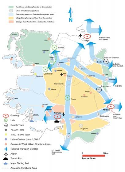
Claremorris Local Area Plan 2013-2019

ii
Claremorris Local Area Plan 2013-2019

Table of Contents

Section 1:       Introduction .................................................................................................... 1
  1.1         Purpose of the Claremorris Local Area Plan 2013-2019....................................... 1
  1.2         Statutory Context ................................................................................................ 1
  1.3         Plan Area ............................................................................................................. 1
  1.4         Public Consultation ............................................................................................ 2
  1.5         Plan Format......................................................................................................... 3
  1.6         Environmental Assessments ............................................................................... 3
      1.6.1      Strategic Environmental Assessment (SEA) .................................................. 3
      1.6.2      Habitats Directive Assessment / Appropriate Assessment (HDA/AA)........ 3
      1.6.3      Flood Risk Assessment (FRA)........................................................................ 3

Section 2:       Policy Context................................................................................................. 4
  2.1         Introduction ........................................................................................................ 4
  2.2         Policy Context ..................................................................................................... 4
  2.3         County Context ................................................................................................... 5

Section 3:       Profile of Claremorris...................................................................................... 8
  3.1      Physical ............................................................................................................... 8
  3.2      Historical ............................................................................................................ 8
  3.3      Claremorris Today .............................................................................................. 8
  3.4      Existing Settlement and Land Use Form ........................................................... 9
  3.5      Urban Form and Townscape-Amenity ............................................................... 9
     3.5.1 Urban Form .................................................................................................... 9
     3.5.2 Townscape-Amenity ......................................................................................10
  3.6      Population and Demographic Profile ................................................................10
  3.7      Employment and Enterprise..............................................................................11
  3.8      Retail and Services .............................................................................................12
  3.9      Housing .............................................................................................................12
  3.10     Education and Community Facilities................................................................12
  3.11     Amenity and Recreation ....................................................................................13
  3.12     Infrastructure and Utilities ................................................................................13
     3.12.1     Transport and Pedestrian Movement........................................................13
     3.12.2     Sewerage Infrastructure.............................................................................14
     3.12.3     Water..........................................................................................................14
     3.12.4     Surface Water.............................................................................................15
     3.12.5     Waste Management ...................................................................................15
     3.12.6     Telecommunications .................................................................................15
     3.12.7     Electricity Supply.......................................................................................15
     3.12.8     Gas Supply .................................................................................................15
  3.13     Natural, Cultural and Built Heritage.................................................................15
     3.13.1     Natural Heritage........................................................................................15
     3.13.2     Cultural Heritage.......................................................................................15
     3.13.3     Built Heritage ............................................................................................16
  3.14     Flooding .............................................................................................................17

Section 4:       Development Strategy for Claremorris ..........................................................18
  4.1     Development Strategy........................................................................................18
  4.2     Approach to Land Use Zoning & Future Land Requirements .........................18
  4.3     Population Targets & Accommodating Population Growth .............................19
     4.3.1 Population Targets ........................................................................................19
     4.3.2 Accommodating Population Growth.............................................................19

                                                                     iii
Claremorris Local Area Plan 2013-2019

     4.3.3 Residential Densities .....................................................................................19
     4.3.4 Phasing Strategy of Residential Development ............................................. 20
  4.4     Land Use Zoning Objectives ............................................................................ 20

Section 5:       Policies and Objectives................................................................................. 23
  5.1        Introduction ...................................................................................................... 23
  5.2        Strategic Role of Claremorris ............................................................................ 23
  5.3        Economic Development ................................................................................... 24
  5.4        Town Centre Area ............................................................................................. 25
  5.5        Residential Development.................................................................................. 25
  5.6        Community, Social, Health, Recreational and Amenity Development ............ 26
  5.7        Transport........................................................................................................... 27
  5.8        Infrastructure and Utility Provision .................................................................. 29
  5.9        Design, Streetscape and Landscape ................................................................. 30
  5.10       Built and Cultural Heritage ...............................................................................31
  5.11       Natural Heritage and Biodiversity.................................................................... 32
  5.12       Environmental Protection................................................................................. 33
  5.13       Land Use ........................................................................................................... 34

Section 6:       Development Management Standards and Guidance.................................. 35
  6.1      Introduction ...................................................................................................... 35
  6.2      General Design and Layout Guidance.............................................................. 35
     6.2.1 Design / Scale .............................................................................................. 35
     6.2.2 Building Lines .............................................................................................. 35
     6.2.3 Building Height and Massing ...................................................................... 35
     6.2.4 Site Coverage ................................................................................................ 36
     6.2.5 Plot Ratio ...................................................................................................... 36
     6.2.6 Infill Development ........................................................................................ 36
     6.2.7 Backland Development................................................................................. 36
     6.2.8 Access for All................................................................................................. 36
     6.2.9 Parking Standards......................................................................................... 36
     6.2.10     Signage and Lighting ............................................................................... 37
     6.2.11     Sewerage ................................................................................................... 38
     6.2.12     Water......................................................................................................... 38
     6.2.13     Surface Water............................................................................................ 38
     6.2.14     Roadside Development ............................................................................ 38
     6.2.15     Public Rights of Way ................................................................................ 39
     6.2.16     Existing Natural and Built Features on Site ............................................ 39
     6.2.17     Seveso II Site – Calor Gas Teo ................................................................. 39
  6.3      Residential Development...................................................................................41
     6.3.1 Layout Requirements ....................................................................................41
     6.3.2 Density ...........................................................................................................41
     6.3.3 Dwelling Type .............................................................................................. 42
     6.3.4 Building Line ................................................................................................ 42
     6.3.5 Public Open Space........................................................................................ 42
     6.3.6 Private Open Space (houses only) ................................................................ 42
     6.3.7 Overlooking .................................................................................................. 43
     6.3.8 Naming of Residential Estates..................................................................... 43
     6.3.9 Phasing within Residential Development .................................................... 43
     6.3.10     Traffic Arrangements within Residential Developments ......................... 43
     6.3.11     Apartments ............................................................................................... 43
  6.4      Community Facilities........................................................................................ 45
     6.4.1 Schools .......................................................................................................... 45
     6.4.2 Childcare Facilities ....................................................................................... 45
     6.4.3 Nursing Homes ............................................................................................ 46

                                                                   iv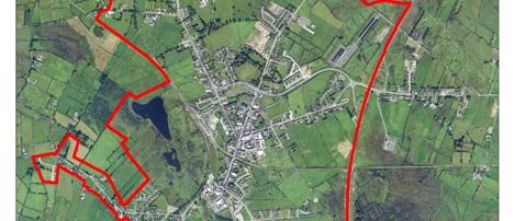
Claremorris Local Area Plan 2013-2019

      6.4.4 Burial Grounds.............................................................................................. 46
      6.4.5 Fire & Emergency Services .......................................................................... 47
   6.5     Retailing............................................................................................................ 48
      6.5.1 General.......................................................................................................... 48
      6.5.2 Location ........................................................................................................ 48
      6.5.3 Design........................................................................................................... 48
      6.5.4 Shopfronts ..................................................................................................... 48
   6.6     Industry, Warehousing and Business Park Development ................................ 50
      6.6.1 General.......................................................................................................... 50
   6.6.2 Site Layout and Building Design Guidelines ................................................... 50
   6.7     Heritage ............................................................................................................ 53
      6.7.1 Archaeology .................................................................................................. 53
      6.7.2 Protected Structures...................................................................................... 53
      6.7.3 Natural Heritage........................................................................................... 54
   6.8     Flooding ............................................................................................................ 56

Land Use Zoning............................................................................................................... 59
Objectives Map.................................................................................................................. 66

Map 1                 Seveso II Site Consequence Zones                                                                      40
Map 2:                Flood Risk                                                                                            56
Map 3:                Land Use Zoning                                                                                       65
Map 4:                Objectives Map                                                                                        68

                                                                    v
Claremorris Local Area Plan 2013-2019
Section 1: Introduction
1.1 Purpose of the Claremorris Local Area Plan 2013-2019
This plan provides a policy framework to guide and manage the future growth and sustainable
development of Claremorris. It sets out objectives for the zoning of land for particular uses and
provides the framework against which planning applications will be assessed. The overall strategy
of the plan has regard to national, regional and county policy and guidance, as well as the
aspirations and views of the local community put forward during the public consultation phase of
the plan preparation process. Claremorris is designated as a Key Town in the County Settlement
Hierarchy (Mayo County Development Plan 2008-2014), therefore a strategic framework is
required to promote the sustainable growth and development of the town in a manner that is
consistent with this designation whilst ensuring that its unique environmental and architectural
characteristics are protected and enhanced.
1.2 Statutory Context
The Claremorris Local Area Plan 2013-2019 has been prepared in accordance with Sections 18-
20 of the Planning and Development Acts 2000-2010. It replaces the Claremorris Local Area
Plan 2006 and will remain in force for a period of 6 years from the date of adoption by Mayo
County Council or such longer period as may be determined by reason of a deferral under
Section 19(1)(d) of the Planning and Development Acts 2000-2010 or until such a time as it is
replaced by an Area Plan for Claremorris incorporated into the Mayo County Development Plan
2014-2022.
A Local Area Plan (LAP) is required to be consistent with the objectives of the County
Development Plan, its Core Strategy, and any regional planning guidelines that may apply to the
area of the plan. Accordingly, this LAP should be read in conjunction with the Mayo County
Development Plan 2008-2014 which sets
out the overarching development Fig 1: Aerial view of Claremorris showing LAP
strategy for the county. Where any Boundary
provision of the LAP conflicts with the
provisions of the County Development
Plan (as varied or a new CDP) the
provisions of the LAP shall cease to have
effect.
As the development strategy set out in
this LAP will shape the future growth
and development of Claremorris it is
therefore an important document, which
will affect all those who live and work in
Claremorris or who have an interest in
its future development.
1.3 Plan Area
The LAP refers to the area located
within Claremorris Town Boundary (See
Fig. 1). The total LAP area extends to
approximately 607Ha (1500acres). The
LAP boundary has been revised from
that established under the Claremorris
Local Area Plan 2006, by excluding lands
that cannot connect by gravity feed to
the existing sewerage network, and is
defined by the following:
location of existing and permitted developments
the role of Claremorris as a Key Town in the County Settlement Strategy
1
Claremorris Local Area Plan 2013-2019
the need to consolidate the overall development of the town by integrating existing
residential, industrial, recreational and community developments on the outskirts of the
town within a defined development boundary
the consideration of the National Climate Change Strategy 2007 – 2012 and Smarter
Travel: A Sustainable Transport Future
the location of strong, physical boundaries such as roads, by-pass, railway line and speed
limits
the location of services
the need to offer locational choice for future development
proximity to community, employment opportunities and commercial facilities
the need to ensure a compact urban form and to maintain a clear definition between
town and surrounding countryside
the need to protect the natural and built heritage
1.4 Public Consultation
The Planning and Development Acts 2000-2010 requires the planning authority to take whatever
steps it considers necessary to consult the public before preparing a Local Area Plan. Mayo
County Council engaged in a wide-ranging public consultation exercise with the general public,
the local community, various service providers and other relevant agencies during the pre-draft
stage of the plan preparation process.
This included notification in three local newspapers and a ‘Public Drop-In Consultation Session’
in the Mayo County Council Area Office in Claremorris. The public were invited to attend the
‘Drop-In Session’ to discuss the process involved in the preparation of the LAP and make their
views known. Written submission was also invited as part of the pre-draft consultation phase.
Issues raised during the pre-draft consultation phase related to:
General Town Centre Traffic, Transportation,
designation of the town for farmers market for town Movement and Access
Foreign Investment Status centre pedestrian linkages in the
and Tourist Designation green mile linking town
maintenance of ‘very clean development between re-examining parking
air environment North and South of town provision in the town
potential of Claremorris to rejuvenation of the town Ballinrobe railway line as a
become Irelands first ‘Eco- centre by targeting future greenway
Town’ brownfield sites railway serving Ireland West
extension of town boundary enhancement of town core Airport Knock
to include Clare lake forest by incentives to residential
greenway and Golf Course living in or within walking
distance of the town
Environmental/Visual Community Facilities Zoning
examination of flooding in creation of pedestrian links re-examine zoning and
line with guidelines within the town rezone lands to current or
visual improvements to the potential of walking routes permitted uses
town, particularly along and greenways provide alternative to the 3
approach roads creating a feature of the bed roomed semi detached
historic well house.
provision of skate park
provision of sufficient lands
for educational facilities and
recreational facilities
The consultation process was integral in shaping the strategy, aims and objectives of the LAP.
Accordingly, it should not be viewed as a regulatory document, but rather as an expression of the
2Claremorris Local Area Plan 2013-2019
Council’s vision, in partnership which the wider public, for the sustainable development of
Claremorris over the next 6 years and the steps needed to achieve this vision.
1.5 Plan Format
This LAP consists of a single document made up of a written statement and associated maps.
Section 1 Introduction to the LAP
Section 2 Sets out the strategic planning context for Claremorris
Section 3 Survey and analysis of the area
Section 4 Sets out the development strategy for Claremorris
Section 5 Sets out the Policies and Objectives for Claremorris
Section 6 Sets out the development management standards and guidelines
1.6 Environmental Assessments
1.6.1 Strategic Environmental Assessment (SEA)
SEA is a formal, systematic evaluation of the likely environmental effects of implementing a
proposed plan, or other strategic action, in order to ensure that these effects are appropriately
addressed at the earliest possible stage of the decision making process on a par with economic
and social considerations.
Claremorris does not come under the mandatory requirements for SEA as set out in the Planning
and Development (SEA) Regulations 2011. As part of the plan preparation process, the planning
authority carried out an assessment (screening) of the proposed LAP in accordance with the
criteria specified in Schedule 2A of the Planning and Development (SEA) Regulations 2004, as
amended. The prescribed environmental authorities were consulted in this regard. Following
this process, the Planning Authority determined under article 14 A (5) of the Regulations, that a
strategic environmental assessment is not required in respect of the proposed Claremorris LAP.
1.6.2 Habitats Directive Assessment / Appropriate Assessment (HDA/AA)
Local Area Plans must comply with the provisions of Article 6(3) and (4) of the Habitats
Directive 92/43/EEC, which requires an Appropriate Assessment of any Plan or Project,
whether it is within or outside a designated ‘Natura 2000’ site, which may impact upon the
conservation objectives of that site. Natura 2000 sites are those identified as sites of Community
Importance under the Habitats Directive (Special Areas of Conservation SAC) or classified as
Special Protection Areas (SPA) under the Birds Directive 79/409/EEC. An Appropriate
Assessment shall be prepared in accordance with Part XAB of the Planning and Development
Acts 2000-2010.
HDA Stage 1 screening of the Claremorris LAP was carried out. There are no Natura 2000 sites
located within the Plan boundary and the Plan includes policies and objectives which ensures that
the town will develop in a sustainable manner; facilitating future development whilst protecting
designated sites and the natural heritage of the town. The planning authority had determined that
the Claremorris LAP will not result in significant adverse effects on the integrity of the Natura
2000 network. Therefore Stage 2 Appropriate Assessment in not required in respect of the
Claremorris LAP.
1.6.3 Flood Risk Assessment (FRA)
A Strategic Flood Risk Assessment was carried out during the preparation of the Claremorris
LAP in accordance with ‘The Planning System and Flood Risk Management Guidelines 2009’
(Department of the Environment, Heritage and Local Government). It provided an appraisal
and assessment of available flood risk data on all land use proposals within the LAP area. The
process identified flood risk indicators in each area and where it was demonstrated that lands may
be at risk of flooding, either, modifications were made to land-use proposals or a more detailed
flood risk assessment would be required.
3Claremorris Local Area Plan 2013-2019
Section 2: Policy Context
2.1 Introduction
The Claremorris Local Area Plan is at the lower level of a hierarchy of plans which include the
National Development Plan 2007 – 2013; the National Spatial Strategy (NSS); the Regional
Planning Guidelines for the West Region 2010 – 2022 (RPG); the Mayo County Development
Plan 2008 - 2014 (MCDP) and the Mayo County Development Board 10 Year Integrated
Strategy. This LAP has been informed by these policy documents and also by other relevant
national planning policies; Government guidelines and documents including (but not limited to)
the following:
Guidelines for Sustainable Residential Development in Urban Areas 2009
Urban Design Manual 2009
Sustainable Urban Housing: Design standards for new apartments 2007
The Planning System & Flood Risk Management 2009
National Climate Change Strategy 2007 – 2012
Smarter Travel: A Sustainable Transport Future
Retail Planning Guidelines 2012 and the Retail Design Manual
The provision of Schools and the Planning System 2008
Spatial Planning and National Roads, Guidelines for Planning Authorities 2012
In addition, various issues were identified during the pre-draft consultation phase which have also
been taken into consideration in drafting this LAP.
2.2 Policy Context
Fig 2: Claremorris in the context of the West
The National Spatial Strategy 2002- Region
2020(NSS)
The National Spatial Strategy outlines an
overall National approach to spatial
planning. Its aim is to facilitate balanced
regional development throughout the
Country. In Mayo, the NNS identifies
the towns of Ballina and Castlebar as a
linked hub, the aim of which is to
complement the nearby gateways of
Galway and Sligo, whilst also providing
services to its associated catchments. It
also emphasises the potential role of
smaller towns (such as Claremorris) in
achieving balanced regional development
through various measures, including
public and private investment in essential
services, appropriate development and
improving attractiveness of the towns.
The NSS identifies Claremorris in an
area of “Village Strengthening and Rural
Area Opportunities”, in which local Source: National Spatial Strategy 2002-2020
authorities should examine closely the
potential for new residential, commercial and local employment related development within the
structure of small towns and villages. This is of central importance to the economic restructuring
of rural areas. Furthermore, the NSS states that local authorities should use their local knowledge,
resources and legal powers under the planning and derelict sites legislation to encourage and
facilitate development, supported at national level by various mechanisms such as the urban and
village renewal schemes.
4Claremorris Local Area Plan 2013-2019
Regional Planning Guidelines for the West Region 2010-2022
The Regional Planning Guidelines for the West Region 2010 – 2022 (RPG’s) sets out a
framework for the long term strategic development of counties Mayo, Galway and Roscommon
(West Region). The Guidelines aim to deliver balanced regional development in the Region with
specific objectives to stimulate social, economic and cultural development.
Claremorris is identified as a Key Town in the RPGs. The overall Settlement Strategy Goal is ‘to
develop the strategic role for the key towns and support sustainable towns through County development Plans and
Local area Plans which take account of employment, community, infrastructure and environmental requirements in
serving the urban and rural hinterland areas.’
The key investment priorities related to Claremorris that are required to support the sustainable
development of the region are as follows:
completion of the N/M/17 and N/M/18 Gort to Claremorris Duel Carriageway
reclassification of the N60/N61 Athlone to Castlebar via Roscommon to a National
Primary Road and upgrade
provision of adequate water and waste water facilities for all areas
completion of the re-opening of the Western Rail Corridor
The RPGs also set out population targets for 2016 and 2022 based on the Regional population
targets issued by the DoEHLG in 2009. The Guidelines set out population targets for the
County as a whole, with growth allocated between the linked hubs and the remainder of the
County.
2.3 County Context
Mayo County Development Plan 2008-2014
The Mayo County Development Plan 2008-2014 was varied in 2011 to incorporate a Core
Strategy. The purpose of the Core Strategy is to set out an evidence based strategy for spatial
development of the County and to demonstrate that the development objectives in the
development plan are consistent, as far as practicable, which national and regional policy set out
in the NSS and RPGs. A central component of the Core Strategy is the County Settlement
Strategy based on a settlement hierarchy which is consistent with the spatial structure, aims and
objectives of the NSS and RPGs. The main elements of the Core Strategy are outlined below:
The Core Strategy
Settlement Hierarchy Population and Housing
Castlebar-Ballina a linked hub sets out population targets for 2016 and 2022
11 Key Towns; 2nd tier in the settlement distributes greatest proportion of future
hierarchy population to the Key Towns
Claremorris designated as a Key town target population for Claremorris is 3488
key towns should develop a strategic role and persons in 2016 and 3845 persons in 2022
support development; enable them to act as 320 housing units requires for 2016 and 534 for
significant providers of services in their own 2022.
areas and generate spill-over effects potential housing stock of 637 units 1
132Ha of undeveloped residential zoned lands;
only 32 required to meet future population
requirements
excess of 100Ha residential zoned lands
options to be considered in addressing surplus
lands; discontinuing the zoning objectives; re-
zoning; designating as a “Strategic Land
reserve”; phasing
1 This is the potential housing stock that could be realised from the completion of unfinished estates, planning permissions for
residential development that has not commenced and estimated vacant residential units in Claremorris
5Claremorris Local Area Plan 2013-2019
The County Settlement Strategy
Guiding Principle Objective
Strengthening the network of Key towns and Overarching objective for all towns including
smaller settlements in the settlement hierarchy in Claremorris is to support and facilitate ongoing
order to encourage more strategically focused and development, renewal and improvement through a
plan-led development throughout the County’s range of measures such as:
small town and village structure thereby avoiding adequate provision of suitable zoned land to
unsustainable commuter driven and car based accommodate population growth and
development. commercial development
provision of water and roads infrastructure
enhancement of the physical and townscape
environment
appropriate infill and back-land development
identification of areas in need of regeneration
and measures to ensure their sustainable
development
sustainable and sympathetic re-use of
brownfield lands and the existing built
environment rather then developing greenfield
lands
provision of a high level of social community
and recreational facilities.
Claremorris: A Key Town in the Mayo County Settlement Strategy
The promotion and development of a number of Key support towns for targeted population
growth is one of the fundamental elements of the Strategy. Claremorris is identified as one of 11
such towns in the settlement hierarchy.
Policy P/CSS 2.1 as set out in the Core Strategy of the Mayo County Development Plan is to
promote and facilitate the growth and sustainable development of the key towns “towards achieving
the population targets set out in the Core Strategy, with an appropriate range of social and physical infrastructure,
facilities and services, including retail and commercial and enterprise development to serve the inhabitants of those
towns and their rural hinterlands.”
The County Settlement Strategy recognises the potential of Claremorris as a transport hub in
view of its location at the intersection of strategic transport infrastructure (road and rail), Policy
P/CSS 2.2 supports and promotes this potential within a framework “which supports the integration of
transport and land use zoning”.
The County Settlement Strategy also recognises and supports the particular potential of
Claremorris due to its location along the Western Rail Corridor. In this regard it is a policy as
expressed in Policy P/CSS 2.3 to “Promote and support the growth and sustainable development of the towns
located along the Western Rail Corridor.”
The LAP must be consistent with the objectives in the County Development Plan and therefore,
the above objectives underpin the development strategy for Claremorris and the detailed policies
and objectives of the LAP.
Other policy documents at the county level which have informed the LAP include:
Mayo County Housing Strategy 2008 Mayo County Retail Strategy 2008
Specific reference to Claremorris in the Strategy is as Claremorris is within the 4th tier of the national
follows: retailing hierarchy and a 2nd tier in the county
the planning authority as a general policy retailing hierarchy
reserve the maximum permissible 20% of the supports retail warehousing in Claremorris due to
land zoned for residential, or for a mix of its strategic potential as a key retailing centre.
residential and other uses in the local towns recognised as having key roles to play in serving
such as Claremorris for Social and affordable the shopping patterns and needs of Mayo
6Claremorris Local Area Plan 2013-2019
housing. a diverse range of comparison and convenience
outlines the details of numbers built and shopping in the town centre. The town is now a
required for the town over the lifetime of the target for many national chains and multiples.
strategy. the environmental appearance and quality of the
town centre has been enhanced in recent years
through County Council investment in the
streetscape and public realm.
Mayo County Development Board 10-year Integrated Strategy
“Maigh Eo Le Cheile le Neart – Mayo County Development Board 10-year Integrated Strategy” sets out a ten
year strategy for economic, social and cultural development of the County. Specific reference to Claremorris in
the strategy is as follows:
the strong urban structure within the County, with the larger towns of Ballina, Castlebar, Westport and
Claremorris provides a strong basis for urban critical mass in the functional zone of Mayo and needs to be
further developed through greater linkages and co-operation.
Claremorris has the potential to become a regional transportation hub were certain transportation
developments to occur
7Claremorris Local Area Plan 2013-2019
Section 3: Profile of Claremorris
3.1 Physical
Claremorris is situated in the undulating plains of southeast Mayo. It is located 28 km southeast
of Castlebar and 61 km North of Galway City. It is strategically located within the county and
the West Region, at the junction of two major National Routes, the N17 (Sligo/Galway) and N60
(Castlebar/Roscommon for Athlone and Dublin). It has direct rail links to Dublin and potential
future rail links along the Western Rail Corridor and is 26 km from Ireland West Airport Knock.
Fig 3: Location of Claremorris Two important regional
Routes, the R331 from
Ballinrobe and the R320
from Kiltimagh also
terminate in the town.
To the south are Clare
and Mayfield Loughs,
which constitute
valuable natural
amenities for the town.
It is the fourth largest
town in the County and
is the established
administrative,
commercial and service
centre for a considerable
hinterland in this part of
the County.
3.2 Historical
Claremorris, translated from the Gaelic ‘Clár Clainne Mhuiris” meaning ‘the plain of the family of
Morris’ takes its name from the famous Norman invader, Maurice de Prendergast who came to
Ireland with Strongbow in 1170 and was later granted a large portion of lands in these parts.
By 1777 the basic linear pattern of the town with its distinctive market square had developed. In
1822 the R.C Chapel was built, this was later demolished and the site now houses the town hall.
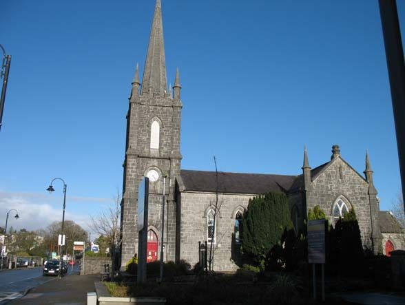
The present R.C Church was built in 1911. Also around the early to mid 1800’s a large
courthouse was built as was St. Johns’ Protestant Church. St. Johns Church in now the town
library.
By 1836 Claremorris had about 300 houses and 1476 inhabitants. Between 1820 and 1880 the
town endured the ravages of the Famine. 1863 saw the opening of the railways to the town.
Claremorris enjoys a rich built heritage as reflected in the number of structures listed in the
Record of Protected Structures (12) and the number on monuments on the Record of
Monuments and Places (26).
3.3 Claremorris Today
Claremorris is the fourth largest town in Mayo and is an established administrative, commercial
and service centre for both the inhabitants of the town and a considerable rural hinterland. The
town has developed over the last few years, with the opening of the Silverbridge Shopping Centre
at the northern end of the town centre, a large retail warehousing park south of the town centre
and the McWilliam Hotel. Chapel Lane has been developed from an almost derelict state to a
commercial street. The public swimming pool was redeveloped into a modern leisure complex in
2009 and a new Garda Station was developed in Mount St in 2008. Although there has been
significant investment in commercial properties in the town a report by GeoDirectory has
highlighted that 18% of commercial property in the town is vacant. (128 premises).
8Claremorris Local Area Plan 2013-2019
A considerable amount of new housing development has been constructed within the LAP area
over the last 6 years; mostly on residential zoned lands to the northern and western side of the
town. Claremorris is also well serviced with a broad range of social and community services and
recreational facilities.
3.4 Existing Settlement and Land Use Form
Claremorris is centrally located within the County at the junction of pivotal transportation routes.
It is bounded by the National Primary Road N17 to the east (Claremorris by-pass), and nearly all
the development in the town has taken place to the west of
this strong physical boundary. The inner relief road acts as Emerging Issues
an internal boundary between the town centre zone and expansion of core retail
(with the exception of the Silverbridge shopping centre) the area without links to town
centre
mainly residential and community type developments
dereliction and vacancy in
Town Centre
Retail development generally centres around the town centre
consolidate residential
area but has expanded beyond with the development of the development
Silverbridge shopping centre. The inner relief road acts as a
barrier separating these two retail areas. Retail warehousing
has developed in the area to the south of the town centre along the old Ballindine road, which
has resulted in some businesses relocating from the town centre. Therefore the core retail
function of Claremorris stretches from the shopping centre in the north through the town centre
area to the retail parks to the south.
Industrial development has mainly occurred in the north part of the town with the development
of an industrial park along the Kiltimagh road. The old Ballindine road has seen some
development of small manufacturing units, but the main industrial area is to the north of the
town.
Housing development has mainly expanded to the north and west of the town centre and has
been restricted to the south due to the location of the Seveso II Site “Calor Gas Teoranta” and
other industrial/commercial uses.
Active sports and recreation facilities comprising GAA training pitches, soccer pitches and a
running track are located in the north of the town and the GAA pitch, new swimming pool
complex and tennis club are located in the town centre. McMahon Park adjacent to Clare Lough
and children’s playground are located to the south.
3.5 Urban Form and Townscape-Amenity
3.5.1 Urban Form
Four distinct areas can be identified within the town boundary:
the town centre area, which is bounded to the north by the inner relief road and to the
south by the old railway line. This consists of the main thoroughfares of Main St.,
Dalton St., James St., and Lower James St., and also includes Market Square and
adjoining streets.
north of the town centre, and the inner relief road, is the newly constructed Silverbridge
shopping centre
south of the town centre, this area is comprised mainly of larger scale commercial/whole
sale type development, such as hardware, sports and other goods normally associated
with this type of development
outlying areas, comprising mainly of residential development, and also the towns main
amenity and open space provision and community facilities. Also to the north along the
Kiltimagh road is an existing industrial park.
9Claremorris Local Area Plan 2013-2019
3.5.2 Townscape-Amenity
Significant improvements to the townscape have been carried out
over the last 6 years, particularly around the Market Square and Emerging Issues
Dalton Street areas. Traditional shopfront design is re-emerging in need to create a sense of
the town as new development proposals are constructed. Off- place for the town centre
street car parking with pedestrian links to the main streets have vacancy, disrepair of
improved pedestrian movements within the town. However, buildings
Mount Street and Lower James Street have not seen any very little residential uses
improvement with many buildings vacant and falling into in the town centre area
disrepair. Other notable changes are the increased number of need for signage to
commercial premises on the upper floors of the town centre promote the Town Centre
buildings which has reduced the residential population of the town area
centre. Signage along the approaches to the town clearly indicates
directions to other nearby town, but there is no direction to the town centre.
The town centre area appears to have lost its sense of importance in the overall context of
Claremorris. It needs regain its role as the hub of commercial/retail activity through measures
which will improve the townscape and overall amenity to enable it become a thriving, vibrant
town attractive to the local community, visitors and investors.
3.6 Population and Demographic Profile
Existing Population Profile
The 2011 Census data is used for population and age cohort. Other data from the 2011 Census
was not published during the preparation of this LAP. The 2006 Census data is used in this LAP
where the 2011 data is not yet published.
Table 1: Population of Claremorris and Mayo 2006 to 2011
2006 2011 Change %
06 to 11 Change
Claremorris 2595 3412 817 +31.5%
Mayo 123839 130638 6799 5.5%
Source: CSO Census of Population 1996; 2002; 2006
The population of Claremorris was 3412 in 2011; it is the fourth largest town in Mayo and has
been growing consistently since 1996. The town has experienced a substantial population growth
of 31.5% between 2006 and 2011, significantly higher than the growth of the County at 5.5%
over the same time period.
Table 2: Age Profile of Population
0-14 15-24 25-44 45-64 65+ Total
Claremorris 721 449 1147 660 435 3412
% 21% 13% 34% 19% 13% 100%
Source: CSO Census of Population 2011
Table 2 above indicates that the working age cohort (15 to 64) represents 66% of the population,
which is two-thirds the population of Claremorris. It also indicates that 34% of the population is
within the dependent age cohort (0-14 and 65+).
Future Population Growth
The Core Strategy in the Mayo County Development Plan sets out population targets for the
County as a whole and for individual towns in the Settlement Hierarchy in accordance with the
Regional Planning Guidelines for the West 2010-2022. It also sets out the associated housing
and residential land requirements necessary to support population growth in individual
settlements.
10Claremorris Local Area Plan 2013-2019
The Core Strategy sets a population target of 3488 persons in 2016 and 3845 persons in 2022.
However, the population of Claremorris grew unexpectedly by 31.5% to 3412 persons between
2006 and 2011 almost reaching the Core Strategy target population for the year 2016. Given the
strategic role of the town of Claremorris within County Mayo and the
wider sub-region at the confluence of important road and rail routes, the Emerging Issues
Planning Authority has taken an evidence based approach in population growth greater
determining the future sustainable growth of the town due to than Core Strategy target
circumstances that have arisen. Therefore, in the opinion of the
Planning Authority the approach remains consistent with relevant policies and objectives as set
out in the Mayo County Development Plan, the National Spatial Strategy and the Regional
planning Guidelines for the West Region. Therefore the population target for Claremorris over
the lifetime of the LAP is 3845 persons, an increase of 433 persons from 2011 to 2018.
3.7 Employment and Enterprise
The number of persons in employment living in Claremorris was 1402 persons in 2011.
Table 3: Persons Ages 15 Years and Over Classified by Economic Status in 2006
for 1st Job
Unemplo
Disabled
yed (lost
At home
Looking
At Work
Student
looking
Retired
family
Sick /
Other
Total
after
job)
Claremorris 1402 31 303 246 214 380 106 9 2691
Source: CSO Census of Population 2011
Table 4 gives an indication of the distances travelled to work, school or college of all individuals
over age of 5 (thus including students going to primary and secondary school). The figures
indicate that Claremorris is a nodal point for commuters, 20% travel a distance of 15 to 49 km
which would possibly include all the smaller towns in the hinterland and Castlebar and Tuam.
8% travel a distance greater than 50km which would include Galway. 50% travel a distance of up
to 4km which indicates that 40% of this cohort live, work or school in Claremorris. These
percentages would significantly alter if school going children where removed from the
calculations.
Table 4: Distance travelled to work/school by persons over 5 in 2006
Distance 0 1 2-4 5-9 10-14 15-24 25-49 50+ Not Total
Travelled Km Km Km Km Km Km Km Km Stated
Claremorris 11 328 487 126 62 143 206 135 196 1694
% 1% 19% 29% 7% 4% 8% 12% 8% 12% 100%
Source: CSO Census of Population 2006
Table 5 gives a breakdown of the employment classification of the active workforce living in
Claremorris. The dominant labour market activity in the town is in Commerce and Trade with
25% of employees. Professional and Other sectors are the next most important activity
accounting for 20% and 18%. 11% of the work force is engaged in the agricultural, forestry ad
fishing sectors.
Table 5: Employed persons aged 15 years and over classified by employment type in 2006
Employment No. %
Agriculture, Forestry, Fishing 158 11%
Manufacturing 121 9%
Building and Construction 68 5%
Public Administration 78 6%
Transport and Communications 79 6%
Commerce and Trade 353 25%
Professional 285 20%
Other 260 18%
Total 1402 100%
Source: CSO Census of Population 2011
11Claremorris Local Area Plan 2013-2019
3.8 Retail and Services
Claremorris is identified as a Tier Two town in the Mayo County Retail Strategy 2008 (see
previous section), and plays a key role in serving the shopping patterns and needs of Mayo.
The town centre provides a diverse range of comparison and convenience shopping and has
attracted large retail chains such as Super-value; Tesco and Aldi. A recent report by
Geodirectory states that 18% of all commercial property in
Claremorris is vacant. Emerging Issues
vacancy of retail units in
Retail warehousing has been provided in Claremorris to the Town Centre
South of the town on the old Ballindine Rd. This includes protect core retail function
hardware, sports goods, a toy shop and other smaller retail
units.
A retail survey of Claremorris indicates that 34% of the retail units of the town are vacant.
3.9 Housing
Claremorris has seen a considerable amount of residential development over the last 6 years.
Approximately 300 housing units have been constructed with a further potential 360 units that
have planning permission and could still be developed within the LAP boundary. In terms of
local authority housing, Mayo County Council constructed a small housing scheme of 10 units on
the Ballyhaunis Rd.
The population target for Claremorris over the lifespan of the LAP is 3845 persons which
equates to a growth of 433 persons from 2011 to 2018. The associated number of housing units
required to accommodate this growth is 174 2 . (population growth divided by average household
size).
The Core Strategy indicates that the potential housing yield from unfinished housing estates is
231 units. There is also a potential yield of 125 residential units from extant planning permission
s. (the Core Strategy indicates 206 units, but permission has expired for a development of 81
units). Therefore there is a potential housing yield of 356 housing units that could be realised in
Claremorris within the planning system.
Emerging Issues
In addition, the 2011 Census indicates that there are 300 vacant oversupply of land zoned
housing units in Claremorris (the Core Strategy which predates the for residential
2011 Census estimated 200 vacant housing units). development
current housing potential
Therefore, taking the above factors into consideration, there is a greater than required over
total potential housing yield of 656 housing units that could be the LAP period
realised in Claremorris. vacancy rate of residential
units
The existing permissions are accommodated on 32 hectares of unfinished housing estates
residentially zoned lands within the LAP area. Therefore, there is
an excess of 100 ha of residential land zoned under the 2006 LAP. The issue of excess zoning of
residential zoning is addressed in the Development Strategy Section of this LAP.
3.10 Education and Community Facilities
Claremorris hosts a range of education and community facilitates such as pre school facilities,
primary and secondary schools, sporting facilities, health centres to name but a few. Even
though Claremorris is a reasonably sized urban area in the context of Mayo, most facilities are
within reasonable distances from residential areas.
2
This figure has been readjusted using the 2011 Census of population date as the Core Strategy Data in
the County Development Plan 2008-2014 was based in the 2006 Census of Population.
12Claremorris Local Area Plan 2013-2019
There are 3 privately owned pre-school after care facilities located in the town. The main issues
relating to childcare in Claremorris is the lack of a community based full day care and afterschool
service.
There are two primary schools in Claremorris (Convent of Mercy N.S. and Claremorris Boys
N.S.) The combined enrolment for these schools has increased by 64 pupils from 2001 to 2010.
It is estimated that 12% 3 of the population at any given time is of primary school going age. The
population increase for the predicted plan could yield a potential
Emerging Issues
additional 78 primary school pupils.
absence of community
based child care facility
Claremorris has two post primary schools (Coláiste Cholmáin and
ensure adequate lands
Mount St. Michael) The combined enrolment for these schools zoned for community uses
has decreased by 30 pupils from 2001 to 2010. It is estimated that
8.5% 4 of the population at any given time is of post primary
school going age. The population increase for the plan period could yield a potential additional
55 post primary school pupils.
It may be possible to cater for these additional pupils within existing facilities, but it is considered
prudent to ensure that land around existing schools is retained for educational purposes in order
to facilitate any future needs.
3.11 Amenity and Recreation
Usable public open space within the town boundary is mainly in small pockets of green areas
within existing housing developments. However a large area of natural amenity is located
around Clare and Mayfield Loughs at the southern end of the town. The development of
McMahon Park has opened up access to Clare Lough and has the only accredited walking trail in
Claremorris. The Clare Lake Loop walk is a 3km route around the lake. Plans are ongoing to
extend this loop to connect with the Golf Club and to re-loop the trail back into Claremorris
using Coilte lands. When developed this facility will offer both walkers and cyclists a dedicated
8km off-road trail with the overall aim of establishing the area as a recreational park. Currently
there is a children’s play ground which the local development groups would like to expand to
include more facilities such as a skateboard park. The recreational amenity of Mayfield Lough
has not yet been realised.
Fig. 3: Road Network
Claremorris has a comprehensive
range of sports facilitates including
GAA and soccer pitches, tennis
courts, handball alley and athletic
track. There are also many clubs and
societies catering for a broad range of
age groups and interests.
3.12 Infrastructure and Utilities
3.12.1 Transport and Pedestrian
Movement
Claremorris is located at the junction
of the N17 (National Primary Road
Galway to Sligo) and the N60
(National Secondary Route Castlebar
to Roscommon). Two important
regional roads, R331 from Ballinrobe
and the R320 from Kiltimagh, terminate in the town. The town centre is bypassed to the east by
the N17 Claremorris by pass and to the north by the N60 inner relief road.
3 Department of Education and Skills
4 Department of Education and Skills
13Claremorris Local Area Plan 2013-2019
At present, there are sufficient car parking facilities in Claremorris with both off-street and on-
street parking. In the town centre, the majority of car parking is pay and display, with a large
public car park located at the railway station which is free of charge.
Bus Eireann operates daily services from Ballina, Westport, Galway, Athlone and Sligo that stop
at Claremorris. The Bus Stop is currently located at Dalton Street.
The Dublin to Westport/Ballina train service currently operates four daily services all of which
stop at Claremorris train station. The proposal to re-open the Western Rail Corridor between
Sligo and Limerick could provide a commuter rail link between Claremorris and Galway.
Ireland West Airport Knock is located approximately 30km north of Claremorris along the N17.
It is the only international airport serving the region (Border,
Midlands, West Region), linking the West and North West Emerging Issues
with the UK and many European destinations. improve pedestrian and
vehicular permeability
Pedestrian permeability throughout the town is not clearly
defined, recent town improvement works along the main street and side streets have improved
the situation but there is no clear link between the residential and commercial development that
surround the centre of Claremorris. Also there is a need to define a strong link between the retail
park to the south and the Silverbridge shopping centre to the north through the town centre.
3.12.2 Sewerage Infrastructure
The Claremorris Sewerage Scheme is designed for a population equivalent (PE) of 8,000. The
current treatment plan is designed to cater for an initial loading of 5,333 PE. The treatment plant
is located in the townland of Coolrue approximately 3km from the town centre and discharges to
the Robe River. The plant is based on an activated sludge process with phosphorus and nitrogen
removal. The system combines both foul and surface water sewers. The existing treatment
plant is near to full capacity and any future development
Emerging Issues
proposal will require to be assessed by the Council to
capacity of waste water
determine if there is sufficient capacity available and the system
treatment plant may need to be upgraded to Stage II (PE
capacity of water supply
8000) to cater for any future development of the town.
3.12.3 Water
The Claremorris water supply is sourced from the Lough Mask Regional Water Supply Scheme.
This regional scheme
provides water to a Fig. 4: Water and Sewer Network
number of the larger
towns of Mayo
including Castlebar and
Ballinrobe. The scheme
is currently at full
capacity supplying
30,000m of water per
3
day. A treatment plant
upgrade is expected to
commence towards the
end of 2012 which will
add an additional
10,000m3 of water per
day to the network.
The Claremorris area
currently consumes
4700m3 of water per
day. Any future development proposal will require to be assessed by the Council and / or the
14You can also read