Dee River Basin District Flood Risk Management Plan 2015 2021 - December 2015
←
→
Page content transcription
If your browser does not render page correctly, please read the page content below
Dee River Basin District
Flood Risk Management Plan
2015 – 2021
December 2015

                             1 of 81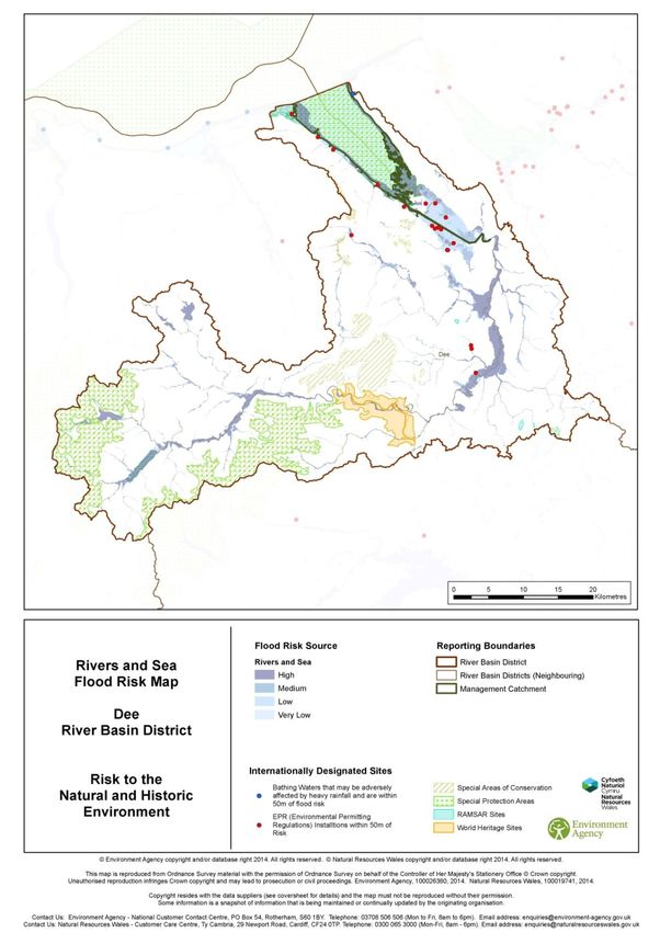
This is a joint draft plan prepared by the Environment Agency and Natural
Resources Wales who protect and improve the environment and make it a
better place for people and wildlife.

Published by:
Natural Resources Wales                       Environment Agency
Cambria house, 29 Newport Road,               Horizon house, Deanery Road,
Cardiff CF24 0TP                              Bristol BS1 5AH
enquiries@naturalresourceswales.gov.uk        enquiries@environment-agency.gov.uk
http://www.naturalresourceswales.gov.uk       www.gov.uk/environment-agency

0300 065 3000 (Mon-Fri, 8am - 6pm)            03708 506506

© Natural Resources Wales                     © Environment Agency 2015
All rights reserved. This document may be     All rights reserved. This document may be
reproduced with prior permission of Natural   reproduced with prior permission of the
Resources Wales.                              Environment Agency.

                                                                                      75 of 81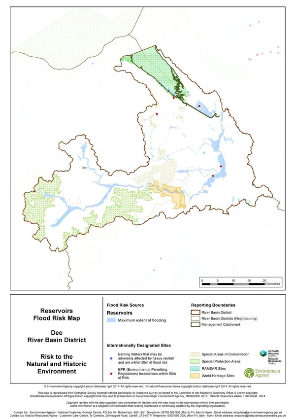
Dee River Basin District
Flood Risk Management Plan
December 2015

                             75 of 81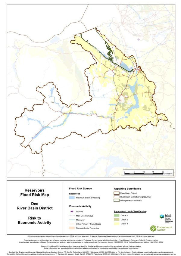
Foreword
The 2013 / 14 winter storms and flooding had significant impacts on many communities,
businesses, infrastructure and the environment within the Dee River Basin District (RBD). In the
future there could be more extremes in the weather with a changing climate leading to more
frequent and more severe flooding.
Investment in flood risk management infrastructure not only reduces the risks of flooding but also
supports growth by helping to create new jobs, bring confidence to areas previously affected by
floods and creating and restoring habitats.
Risk Management Authorities (RMAs) are committed to producing Flood Risk Management Plans
(FRMPs) required by the EU Floods Directive by December 2015. This FRMP is an important part
of meeting that objective and aligns with the guiding principles of the National Flood and Coastal
Erosion Risk Management Strategy.
The FRMP will help promote a greater awareness and understanding of the risks of flooding,
particularly in those communities at high risk, and encourage and enable householders,
businesses and communities to take action to manage the risks. The FRMP will provide the
evidence to support flood and coastal risk management decision making. The highest priority is to
reduce risk to life.
Measures (actions) in FRMPs do not all have secured funding and are not guaranteed to be
implemented. Money is allocated to RMA measures based on current Government policy that
gives the highest priority to the areas at highest risk. The funding for flooding is devolved so RMA
measures are funded by DEFRA in England, in Wales they are funded by Welsh Government.
This document has been produced in consultation with professional partners. The Flood Risk
Management Plan (FRMP) sets out the proposed measures to manage flood risk in the Dee RBD
from 2015 to 2021 and beyond.
In England and Wales, RMAs include Natural Resources Wales, the Environment Agency, Lead
Local Flood Authorities (LLFAs), district councils (where there are no unitary authorities), internal
drainage boards, water companies and highway authorities. These RMAs work in partnership with
communities to reduce the risk of flooding. The Environment Agency and Natural Resources
Wales would like to thank the organisations listed on the previous pages for their contributions and
feedback during consultation.
Flood risk in England and Wales will continue to change as a result of a growing population and a
changing climate. There are many ways to manage flood risk including maintaining and building
new flood defences, building flood resilient homes and working more closely with nature to restore
flood plains. Flood risk management planning is not new and RMAs have been able to draw on the
experience of partners and earlier plans.
The FRMP also sets out how these measures can contribute to improving the environment and
how they support the objectives of River Basin Management Plans (RBMPs) and specifically the
Severn RBMP that Natural Resources Wales and the Environment Agency has produced in
parallel with this FRMP.

Tim Jones                                          Mark Sitton-Kent
Executive Director                                 Director Operations West
Natural Resources Wales                            Environment Agency

                                                                                             75 of 81
Contents
PART A .......................................................................................................................................... 8
Dee Flood Risk Management Plan ............................................................................................... 8
   1. What is flood risk and who manages it?................................................................................... 8
   2. What is a Flood Risk Management Plan? .............................................................................. 12
   3. The layout of this document................................................................................................... 15
   4. How the plan has been developed......................................................................................... 16
   5. How to manage risk ............................................................................................................... 19
PART B ........................................................................................................................................ 22
Managing flood risk in the Dee river basin district ................................................................... 22
   6. Getting to know the Dee river basin district ............................................................................ 22
   7. Key Flood Risk Issues in the Dee river basin district.............................................................. 27
   8. Sub-areas in the Dee river basin district ................................................................................ 38
   9. Conclusions, objectives and measures to manage risk for the Dee river basin district ........... 39
   10. Wales only section............................................................................................................... 47
   11. England only section ........................................................................................................... 59
   12. Implementing the plan ......................................................................................................... 76
Annex 2 - CFMP and SMP policies............................................................................................. 78

                                                                                                                                       75 of 81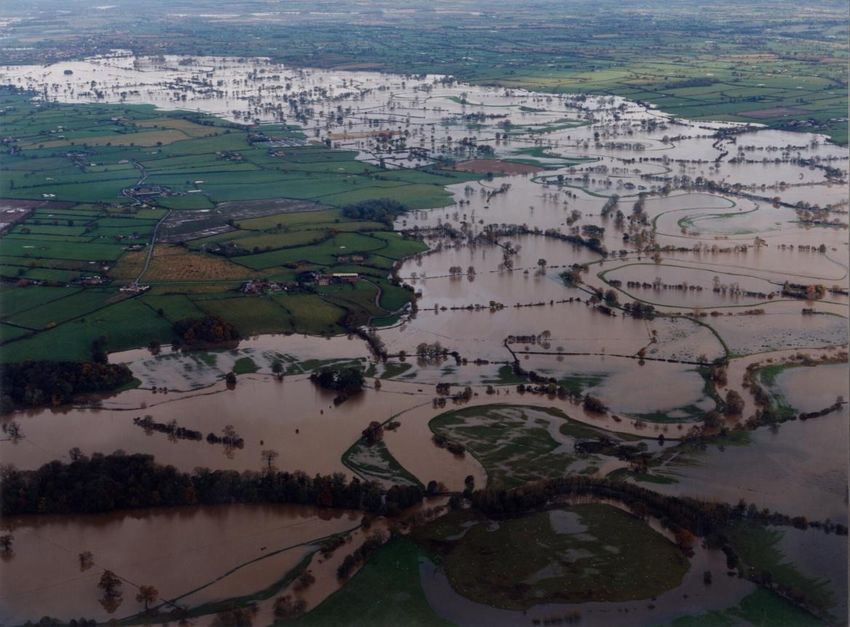
Glossary and abbreviations
Catchment          The watershed of a surface water river system
CaBA               Catchment based approach: an approach to environmental planning that
                   focuses on local engagement and partnerships
CFMP               Catchment Flood Management Plan
Coastal Groups     Voluntary coastal defence groups made up of maritime district authorities
                   and other bodies with coastal defence responsibilities.
Cross Border       Set up under The Flood Risk (Cross Border Areas) Regulations 2012 (SI
Advisory Group     No. 1102). A statutory group made up of representatives from SEPA,
(CBAG)             Environment Agency and local authorities within the cross border areas.
Cross Border       Those areas designated as ‘cross border’ under The Flood Risk (Cross
Areas              Border Areas) Regulations 2012 (SI No. 1102).
Defra              Department for Environment, Food and Rural Affairs
EA                 Environment Agency
EU                 European Union
FCERM              Flood and coastal erosion risk management
Floods Directive   The European Floods Directive (2007/60/EC) on the assessment and
                   management of flood risks.
Flood Risk Area    Areas where the risk of flooding from local flood risks is significant as
(FRA)              designated under the Flood Risk Regulations.
FRMP               Flood Risk Management Plan – plan produced to deliver the requirements of
                   the Regulations.
Government         The term government is used within this report to refer to Defra (the
                   Department for Environment, Flood and Rural Affairs) and Welsh
                   Government.
Groundwater        Occurs when water levels in the ground rise above the natural surface. Low-
flooding           lying areas underlain by permeable strata are particularly susceptible.
HRA                Habitats Regulations Assessment: an assessment undertaken in relation to
                   a site designated under the Habitats and Birds Directives
LLFA               Lead local flood authority
Local FRM          Local flood risk management strategy produced by LLFAs under the Flood
Strategy           and Water Management Act 2010.
Main river         A watercourse shown as such on the main river map, and for which the
                   Environment Agency and Natural Resources Wales has responsibilities and
                   powers
National           National flood and coastal erosion risk management strategy: these are
FCERM              strategies prepared under the Flood and Water Management Act 2010, by
Strategy           the Environment Agency for England and by Welsh Government for Wales.
Natural            The taking care of natural resources such as land, water, air, soil, plants and
Resource           animals with a particular focus on how their management affects the quality
Management         of life for both present and future generations.
NRW                Natural Resources Wales. NRW took over the functions of the Environment
                   Agency in Wales on 1st April 2013.

                                                                                               75 of 81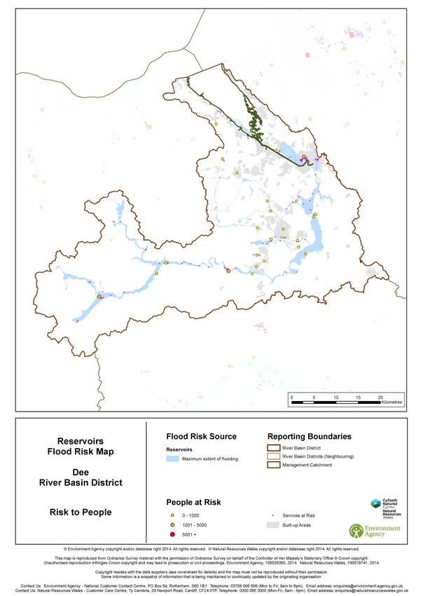
Ordinary         All watercourses that are not designated Main River, and which are the
watercourses     responsibility of Local Authorities or, where they exist, Internal Drainage
(OW)             Boards.
PFRA             Preliminary Flood Risk Assessment – these were required to be published
                 by December 2011 and were the first stage in delivering the Regulations.
Ramsar           Wetlands of international importance designated under the Ramsar
                 Convention
Reservoir        A natural or artificial lake where water is collected and stored until needed.
                 Reservoirs can be used for irrigation, recreation, providing water supply for
                 municipal needs, hydroelectric power or controlling water flow.
Risk             Organisations that have a key role in flood and coastal erosion risk
management       management as defined by the Act. These are the Environment Agency,
authorities      Natural Resources Wales, lead local flood authorities, district councils where
(RMAs)           there is no unitary authority, internal drainage boards, water companies, and
                 highways authorities.
RFCCs            Regional Flood and Coastal Committees
River Basin      These are the reporting units to the European Commission for the Water
District (RBD)   Framework Directive and the Floods Directive.
RBMP             River Basin Management Plan – plan required by the European Water
                 Framework Directive.
River flooding   Occurs when water levels in a channel overwhelms the capacity of the
                 channel.
SAC              Special Area of Conservation
SEA              Strategic environmental assessment
SMP              Shoreline Management Plan
SPA              Special Protection Area
SSSI             Site of Special Scientific Interest
Surface water    Flooding from rainwater (including snow and other precipitation) which has
flooding         not entered a watercourse, drainage system or public sewer.
SWMP             Surface Water Management Plan
Working with     Taking action to manage flood and coastal erosion risk by protecting,
Natural          restoring and emulating the natural regulating function of catchments, rivers,
Processes        floodplains and coasts. An example of this is using land to temporarily store
                 flood water away from high risk areas.
WG               Welsh Government

                                                                                         75 of 81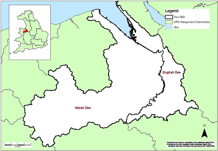
PART A
Dee Flood Risk Management Plan
1. What is flood risk and who manages
it?
The Flood and Water Management Act (2010) defines flooding as any case where land not
normally covered by water becomes covered by water. Flood risk is a combination of
two components: the chance (or probability/ likelihood) that a location will flood from any source or
type of flooding, and the impact (or consequence) that the flooding would cause if it occurred.
Flood risk management is generally concerned with reducing harm which might take the form of
property damage or physical injury to people and wildlife. However, flooding can also have
beneficial effects too, in particular for wetland wildlife as well as some types of agriculture that are
water dependent.
Figure 1: What is flood risk?

   Risk                                    Likelihood                              Impact
                               =                                       x

Risk captures the severity of, or related consequences produced by, a flood event. Impacts can be
social, economic and environmental, for example the number of properties flooded and the level of
associated economic damages. The consequences of a flood depend on the level of exposure
and the vulnerability of those affected.

What is the likelihood of this happening and what does this mean?
Probability (or chance) is a measure of the likelihood that a defined event will occur. The
probability of a flood event is typically defined as the relative frequency of occurrence of that flood
being equalled or exceeded. Probability can be expressed as a fraction, percentage, a decimal or
description, and should always make reference to a time period. For example, the industry refers
to a 1 in 100 chance of flooding in any given year’ or a 1% annual probability of flooding’, which
both refer to the same likelihood.
Assessing impacts of flooding prior to an event usually involves estimating the potential impact of
flooding on people, property and the environment. The theoretical probability of flooding is
illustrated by the Environment Agency and Natural Resources Wales’ Flood Maps which show
flood risk for rivers and the sea, surface water and reservoirs. Flood models which are the basis
for the flood maps use uniform rainfall scenario (the same amount of rainfall falling across the
country), whereas in reality rainfall rates vary greatly from one town to another.
It is not possible to prevent all flooding, but there are a variety of actions which can manage these
risks and their impacts on communities. Flood risk managers must identify all potential options to
manage flood risk and balance the needs of communities, the economy and the environment. Risk
management authorities should work in partnership with each other and communities to manage
flood risk, ensuring that communities are part of the decision making process and understand and
actively prepare for the risks. By working together risk management authorities should actively
seek opportunities to coordinate risk management, encourage partnership funding and deliver
multiple benefits.

                                                                                                75 of 81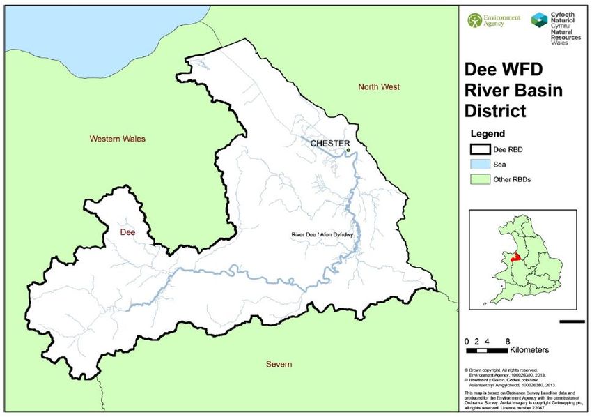
Roles and responsibilities
Table 1 and 2 show the RMAs involved in flood risk management in England and Wales their roles
and responsibilities.
Table 1: Summary of responsibilities for risk management authorities
Flood Source EA / NRW LLFAs District Water Highways Internal
Company Authority Drainage
Boards²
Strategic overview
for all sources of
flooding & coastal
erosion
Main River
The Sea
Surface Water
Surface Water (on
or coming from the
Highway)
Sewer Flooding
Ordinary
Watercourse
Groundwater
Reservoirs * * * * * *
* Please note RMAs have different responsibilities for reservoirs such as regulation, asset management and flood
incident response
² As of 1 April 2015 in Wales the 3 Internal Drainage Districts that were operated by independent boards were
incorporated into NRW in April 2015.
Table 2: Roles and responsibilities of risk management authorities and others involved in
managing flood risk
Organisation Roles and Responsibilities
Environment Agency Permissive powers to manage flood risk from ‘main rivers’, the sea and
reservoirs. Can use enforcement powers to require landowners to take
action to minimise flood risk to others.
Natural Resources Permissive powers to manage flood risk from ‘main rivers’, the sea and
Wales reservoirs. Can use enforcement powers to require landowners to take
action to minimise flood risk to others.
LLFAs Upper tier local council or unitary council. Permissive powers to manage
flood risk from surface water, ‘ordinary watercourses’ (non-main rivers)
and groundwater. Enforcement powers are similar to Environment
Agency and Natural Resources Wales. Upper tier councils also manage
highways.
Water Companies Dee Valley Water and Welsh Water manage the sewerage and water
supply networks and any flood risk arising from them. Also manage
flood risk to any critical infrastructure, such as water treatment plants
and pumping stations.
District Council (only By agreement with the upper tier Lead Local Flood Authority, the District
in England) Council may do some work to manage flood risk. District Councils are
75 of 81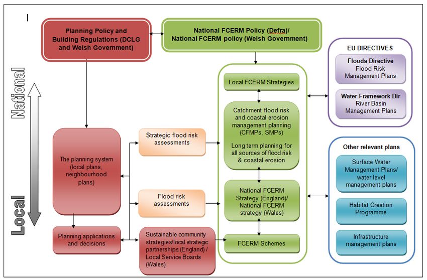
Organisation              Roles and Responsibilities
                          the Local Planning Authority.
Community Council         By agreement with the upper tier Lead Local Flood Authority, the
(only in Wales)           Community Council may do some work to manage flood risk.
Maritime District         As District Councils, but also manage coastal erosion. As many coastal
Council                   defences protect against both erosion and flooding from the sea, these
                          Councils often do both in urban areas.
Riparian Landowner        The owner of land next to a watercourse usually owns the land to the
                          middle of the river (unless property deeds show otherwise). This
                          ‘riparian landowner’ is responsible for maintaining the watercourse to
                          allow free flow.
Communities               Individuals at risk from flooding, or having flooded, are encouraged to
                          form a Flood Action Group or other Community Group as a focus for
                          understanding the issues, considering improvement options and
                          implementing solutions.
Non- RMA owners of        Features and structures that have been designated as a flood defence
flood defences            cannot be altered, removed or replaced without the consent of the
                          responsible authority.
Reservoir owners          In addition to their general duty of care for the public under common law,
                          the owners of reservoirs with an above ground capacity of 25,000 cubic
                          metres or more have a legal duty to have their reservoirs supervised and
                          inspected regularly by experts; in order to prevent dam failures and the
                          dangerous flooding that could result. Reservoir owners could fall into
                          any of the above categories listed in the table.

Flooding from river and the sea
National Flood Risk Assessment (NaFRA) is an assessment of flood risk for England and Wales
produced using local data and expertise. It shows the chance of flooding from rivers and the sea
(both along the open coast and tidal estuaries). The data is presented in flood risk likelihood
categories, which indicate the chance of flooding in any given year.
High - greater than or equal to 1 in 30 (3.3%) chance in any given year
Medium - less than 1 in 30 (3.3%) but greater than or equal to 1 in 100 (1%) chance in any given
year
Low - less than 1 in 100 (1%) but greater than or equal to 1 in 1,000 (0.1%) chance in any given
year
Very Low - these properties may have a greater than 1 in 1,000 chance of flooding in any given
year if defences weren’t present. However, in reality the chance of flooding is reduced below a 1 in
1,000 chance by defences which NaFRA analysis includes.
The computer model used to produce NaFRA results estimates the likelihood of flooding from
rivers and the sea, taking into account defences and the chance that they can fail or be
overtopped. The results, which are presented in maps, databases and excel spreadsheets, can be
used in conjunction with receptor data (number and type of properties and infrastructure) to
estimate the consequences and economic damage associated with flooding from rivers and the
sea.

Flooding from reservoirs
                                                                                            75 of 81
Reservoir flood risk maps show the area that could be flooded if a large reservoir were to fail and
release the water it holds. A large reservoir is one that holds over 25,000 cubic metres. This is a
worst case scenario.
Existing flood management schemes and properties protected
Risk Management Authorities work in partnership with each other and communities to manage
flood risk. The Flood Risk Management Plan sets out the current and proposed measures to
manage flood risk across the Dee RBD. However, RMAs have been undertaking a range of
activities to manage flood risk for many years. Details of these activities can be found in Section 7
Error! Reference source not found.. In some parts of the Dee RBD flood management schemes
are in place to reduce flood risk. The Environment Agency Flood Map for Planning and NRW Flood
Risk Map shows the flood defences that protect against fluvial and tidal floods.
Important flood defences in the Dee catchment include:
• the River Dee flood embankments in Chester
• Sealand main drain flood basin at Clifton Drive, Chester
• Finchetts Gutter outfalls and debris screens at Sealand Road in Chester
75 of 812. What is a Flood Risk Management
Plan?
Flood risk management plans (FRMPs) highlight the hazards and risks from rivers, the sea,
surface water, groundwater and reservoirs and set out how risk management authorities (RMAs)
will work together with communities to manage flood risk.
What is the FRMP for?
Flood Risk Management Plans (FRMPs) are produced every 6 years and describe the sources and
risks of flooding within a river basin district and catchment. They also include information on how
risk management authorities (RMAs) plan to work together with communities and businesses to
manage and reduce flood risk. Over the 6 year planning cycle the FRMP will help promote a
greater awareness and understanding of the risks of flooding, particularly in those communities at
high risk, and encourage and enable householders, businesses and communities to take action to
manage the risks. FRMPs along with River Basin Management Plans (RBMPs) help all those
involved in managing water to make decisions that are best for people and the environment.
Why are FRMPs being prepared?
This is the first cycle of implementing the Flood Risk Regulations 2009. As a result of this
legislation, lead local flood authorities must prepare FRMPs in Flood Risk Areas, where the risk of
flooding from local flood risks is significant (for instance from surface water, groundwater and
ordinary watercourses). The Environment Agency (EA) and Natural Resources Wales (NRW) are
required to prepare FRMPs for all of England and Wales covering flooding from main rivers, the
sea and reservoirs, in line with government guidance.
Flood risk and coastal erosion management activities require careful planning to ensure that
appropriate, sustainable, options are selected and that they are implemented properly. Actions
should be planned effectively, for the long-term, and provide a clear picture of what will be done to
manage risk and provide multiple benefits. This may include, for example, linking with other plans
such as river basin management plans (RBMPs) and supporting biodiversity, habitat creation or
improving water quality. Natural Resources Wales, the Environment Agency and LLFAs are
developing FRMPs by drawing existing information together and building on existing Flood and
Coastal Erosion Risk Management plans such as: Catchment Flood Management Plans (CFMPs),
Shoreline Management Plans (SMPs) and Local Flood Risk Management Strategies (LFRMS)
(see Figure 1).
The Environment Agency, Natural Resources Wales and lead local flood authorities are developing
FRMPs by drawing existing information together, building on and supplementing the existing
planning process (see What types of flood risk are included in the FRMP?
The FRMP covers the flood risks that the Environment Agency and Natural Resources Wales are
responsible for. This is a joint FRMP which the Environment Agency and Natural Resources Wales
have acted jointly to produce.
The FRMP draws from relevant information, in particular, flood hazard and flood risk maps
published under the Flood Risk Regulations. It summarises the risk of flooding from rivers, the sea
and reservoirs.
The FRMP draws relevant conclusions from the flood and hazard risk maps about risks and
opportunities. It sets out and prioritises what needs to be done to manage those risks. The FRMP
shows how flood risk management measures co-ordinate with measures outlined through river
basin management planning under the Water Framework Directive (WFD).
Find out more about flood risk management on the Natural Resources Wales and GOV.UK
websites.
75 of 81).
What the plan does?
This FRMP aims to deliver the aims of the Environment Agency’s National Flood and Coastal
Erosion Risk Management Strategy in England and the Welsh Government’s National Flood and
Coastal Erosion Risk Management Strategy in Wales by setting out the measures to manage flood
risk now and in the future. The FRMP will:
• Help develop and promote a better understanding of flood and coastal erosion risk
• Provide information about the economic and environmental benefits to inform decision
makers
• Identify communities with the highest risk of flooding so that investment can be targeted at
those in most need
Measures in FRMPs do not all have secured funding and are not guaranteed to be implemented.
Money is allocated to all RMA measures in the same way and is based on current Government
policy that gives the highest priority to lives and homes.
What types of flood risk are included in the FRMP?
The FRMP covers the flood risks that the Environment Agency and Natural Resources Wales are
responsible for. This is a joint FRMP which the Environment Agency and Natural Resources Wales
have acted jointly to produce.
The FRMP draws from relevant information, in particular, flood hazard and flood risk maps
published under the Flood Risk Regulations. It summarises the risk of flooding from rivers, the sea
and reservoirs.
The FRMP draws relevant conclusions from the flood and hazard risk maps about risks and
opportunities. It sets out and prioritises what needs to be done to manage those risks. The FRMP
shows how flood risk management measures co-ordinate with measures outlined through river
basin management planning under the Water Framework Directive (WFD).
Find out more about flood risk management on the Natural Resources Wales and GOV.UK
websites.
13 of 82Figure 2: Flood risk management plans and their relationship to other planning initiatives (adapted from the National Flood and Coastal Risk
Management Strategy for England)
14 of 823. The layout of this document
We have divided the plan into two parts:
Part A sets the scene for the FRMPs - what they are, what they are for and how we have
developed them.
Part B goes on to describe the River Basin District (RBD), the flood and coastal erosion risk and
the proposed approach to managing that risk.
How we have developed the plan
Section 4 describes how in partnership the Environment Agency and Natural Resources Wales
have prepared this draft FRMP.
How to manage risk
Section 5 describes some of the terminology we are using, such as ’conclusions’, ’objectives’ and
‘measures’, and how they relate to flood and coastal erosion risk management in this context.
The River Basin District
Section 6 of the plan introduces the Dee RBD. The flood and coastal erosion risks are set out for
the RBD in section 7. We also introduce the ‘sub-areas’ that divide the RBD further.
The sub-areas
Section 8 introduces each of the sub-areas which make up the RBD.
The risk conclusions, management objectives and measures
Sections 9 to 11 set out the risk conclusions, objectives and measures for the RBD and sub-areas.
Implementing the plan, monitoring and reporting
Section 12 sets out the proposals for implementing the plan, including co-ordination with the
implementation of the RBMPs prepared under the WFD.
1 of 814. How the plan has been developed
The approach to developing FRMPs
In 2013 the government agreed that the preferred approach to developing FRMPs would be for the
Environment Agency and Natural Resources Wales to work in partnership with other RMAs, in
particular LLFAs, to pool information to develop an overall plan for managing all sources of flood
risk and coastal erosion. For the first cycle of production of FRMPs, joint FRMPs are not being
pursued in Wales. In preparing this draft FRMP, RMAs have built on relevant information from
existing work (see What types of flood risk are included in the FRMP?
The FRMP covers the flood risks that the Environment Agency and Natural Resources Wales are
responsible for. This is a joint FRMP which the Environment Agency and Natural Resources Wales
have acted jointly to produce.
The FRMP draws from relevant information, in particular, flood hazard and flood risk maps
published under the Flood Risk Regulations. It summarises the risk of flooding from rivers, the sea
and reservoirs.
The FRMP draws relevant conclusions from the flood and hazard risk maps about risks and
opportunities. It sets out and prioritises what needs to be done to manage those risks. The FRMP
shows how flood risk management measures co-ordinate with measures outlined through river
basin management planning under the Water Framework Directive (WFD).
Find out more about flood risk management on the Natural Resources Wales and GOV.UK
websites.
75 of 81and Table ).
The Environment Agency and Natural Resources Wales are co-ordinating the development of this
FRMP with the RBMP so that there is an integrated approach to overall water management for the
benefit of people, the environment and the economy.
Table 3: Sources of FRMP information according to flood risk
Flood risk Existing plans and FRMP information
Flooding from main rivers River Dee Catchment Flood Management Plan
Flooding from the sea North West England and North Wales
Shoreline Management Plan SMP2
Flooding along estuaries Estuary Management Plans
Flooding from reservoirs Reservoir Plans
Consultation and engagement
Consultation and engagement on this FRMP helped improve, inform and shape the plan. By
consulting others we have reached a better final plan.
We consulted on the FRMP from 10 October 2014 to 31 January 2015. As a result of feedback
from the consultation we have improved the information on existing flood risk management and
made clearer links between the FRMP and river basin management plans. We’ve also shown more
clearly how flood management actions help to improve the environment.
We also sought views on the measures within this final plan during the draft FRMP consultation.
These measures are the intention for delivery. However, the majority of these measures are
currently unfunded and each will be subject to assessment and justification to secure funding and if
appropriate, prioritised on a National basis before delivery.
How the Environment Agency and Natural Resources Wales plan
and set objectives
Objectives set out what RMAs want to achieve to manage the risk of flooding. Flood Risk
Management Plans (FRMPs) contain objectives for managing flood risk. Objectives are a common
set of goals agreed by risk management authorities. They state the main ways in which work is
directed to make a difference and reduce flood risk. They cover people, the economy and the
environment. The objectives are split into the 3 categories to help demonstrate the balance of
objectives across the plans but the categories aren’t assigned a weighting in the FRMP. Objectives
are used to plan and prioritise investment programmes to target investment in the most at risk
communities. Prioritisation is then done at an England wide level and Wales wide level. This takes
into account the risk but also considers other factors such as; cost benefits, the level of investment
to date and other aspects such as the potential for external funding opportunities.
This plan covers areas in England where the Environment Agency is the responsible authority for
flood risk management (with regard to main rivers, the sea and reservoirs) and areas in Wales
where Natural Resources Wales is the responsible authority for flood risk management (with
regard to main rivers, sea and reservoirs). Where the draft plan crosses the national boundary,
agreements and arrangements are in place to enable both organisations to develop the draft plan
jointly and ensure that impacts either side of the boundary are understood and agreed by the each
authority.
Management of flood and coastal erosion risk in England and Wales is driven by the National
Strategies for Flood and Coastal Erosion Risk Management for England and Wales, respectively.
These strategies provide the framework for flood and coastal erosion risk management work in the
RBD. The overarching principles of the strategies were used to determine objectives for the RBD
that consider people, the environment and economic activity. Where objectives are specific to only
England or Wales, they are captured in the England or Wales only sections.
1 of 81How each authority delivers against their FRMP objectives differs in England and Wales, as
described in the following sections.
England
Measures to meet the objectives include actions taken forward from the SMP2 (except in the small
number of locations where these now differ following development of more up to date strategies),
incomplete actions from the CFMP where still relevant, and from existing flood risk management
strategies. Over time the aim is to also include actions from more local flood risk management
strategies produced by LLFAs for their areas. This first plan includes a number of ongoing, agreed
and newly proposed actions at the community level. Over time, the Environment Agency shall be
considering further community level actions within the RDB. The aspiration is to add these in future
cycles of the plan.
Funding to RMAs to manage flood risk from watercourses, surface run-off and groundwater is
mainly provided by Defra as flood and coastal erosion risk management grant in aid (FCRM GiA).
Highways authorities and water authorities can apply for GiA funding for projects to reduce flood
risk which wouldn’t ordinarily be within their remit. Regional Flood and Coastal Committees can
also raise local levy to fund local priority projects and works in partnership with others.
Government promotes nationally consistent approaches to assessing and managing flood and
coastal erosion risk and RMAs prioritise public investment in flood and coastal risk management
works according to Treasury and Defra guidance.
The Environment Agency has a role in allocating FCRM GiA and local levy funding to RMAs. Risk
Management Authorities bid for the funding through medium term planning and projects are
selected on the basis of the outcomes delivered, costs and benefits. Taking a risk-based
management approach, resources are targeted to ensure that public money is spent on the works
that provide the greatest benefits to society, and that this money is spent efficiently and effectively.
Under Defra’s partnership funding approach, government funding towards schemes is based on
the numbers of households protected, the damages being prevented and other benefits that would
be delivered. For schemes to proceed where they are not fully funded by government either the
costs would need to be reduced or the remainder of the funding provided through local
contributions. The approach helps achieve the best value for public money and encourages others
to contribute where it is in their interests to do so.
Wales
In order to deliver measures to meet the FRMP objectives, Natural Resources Wales takes a risk
based community approach to prioritise where to best direct investment. This is informed by the
strategic framework provided by CFMPs and SMPs. The strategic framework set by these plans
enable Natural Resources Wales to make short term decisions to manage present day risk whilst
also considering the longer term prediction of risk (for further information on CFMPs and SMPs
please refer to Annex 2).
The risk based community approach of present day risk is done through the Natural Resources
Wales Communities at Risk Register. This is a tool that considers a number of factors to give an
indication of where the most vulnerable communities at risk of flooding from main rivers and the
sea are located across Wales. This is then used to plan and prioritise the Natural Resources
Wales investment programme to target investment in the most at risk communities. Prioritisation is
then done at a Wales-wide level and takes into account the risk calculation from the Communities
at Risk Register but also considers other factors such as the cost-benefit ratio, level of investment
to date and other aspects such as the potential for external funding opportunities. There is also a
facet of Natural Resources Wales work which is reactive to severe weather events, where severe
damage may have occurred, leading to the need for emergency works.
All major flood alleviation schemes in Wales undergo appraisal work to assess options and to
understand the costs and benefits of progressing work; this is done in accordance with Treasury
guidance.
Strategic Environmental Assessment and Habitats Regulations
75 of 81A Strategic Environmental Assessment (SEA) was undertaken to consider the significant
environmental effects of the flood risk management plan. Natural England, Historic England and
the Marine Management Organisation were consulted on the scope of the proposed assessment in
December 2013, and the environmental report sets out the results of the SEA. The report
describes the environmental effects that are significant within the RBD and identifies measures to
mitigate any adverse effects. Opportunities to improve the environment are also considered. . The
SEA took account of the environmental effects of flood risk management measures in the FRMP.
The focus was on the combined effects of the programme of protection measures across a
catchment or flood risk area, rather than individual measures at specific locations.
The scope of the SEA was informed by the consultation with Natural England, Historic England
and the MMO as well as with Natural Resources Wales, Scottish Environment Protection Agency,
Historic Scotland and Scottish Natural Heritage in January 2014. The SEA took account of the
environmental effects of flood risk management measures in the FRMP. The focus was on the
combined effects of the programme of protection measures across a catchment or flood risk area,
rather than individual measures at specific locations.
Using the same assessment approach for both the RBMP and FRMP allows us to compare the
environmental effects directly and consider the interaction between the two plans. The likely
positive impacts of the FRMP are identified in the SEA, as well as mitigation required to manage
the negative effects and opportunities to deliver greater environmental benefits. Indicators are also
set out that indicate the effect of the plan on significant environmental receptors, taking advantage
of existing monitoring that is already carried out by the Environment Agency, Natural Resources
Wales and others.
A Habitats Regulations assessment has been carried out on the FRMP to consider whether the
plan affects designated sites (Special Areas of Conservation, Special Protection Areas and
Ramsar sites). Initial assessment suggests that significant effects are not likely.
How FRMPs have been co-ordinated with river basin management
planning
The Environment Agency and Natural Resources Wales lead on the development of flood risk
management plans and river basin management plans (RBMPs). We aim to co-ordinate work
effectively, and support others to do the same, so that there is an integrated approach to overall
water management for the benefit of people, the environment and the economy.
Each river basin district has a Liaison Panel made up of representatives for the key sectors.
Members bring their experience, knowledge and their sector views acting as a two-way channel
between the panel and their sector. This way of working provides an open forum to discuss and
influence the development of the RBMPs to help us improve water quality.
Find out more about river basin management plans on the Natural Resources Wales and GOV.UK
websites.
Co-ordinating with the RBMP:
Dee RBMP
75 of 815. How to manage risk
Involving communities’ leads to more effective flood and coastal erosion management. RMAs will
continue to work with communities and other stakeholders to manage risk by:
• assessing the sources of flood risk and drawing conclusions about the risks
• setting out what RMAs are trying to achieve and establishing risk management objectives
• determining the best approach to achieving the objectives: by identifying the right measures
and prioritising them
The conclusions, objectives and proposed measures are set out for consultation within this draft
FRMP. Following feedback from the consultation RMAs will work with interested parties to finalise
the FRMP and:
• seek to secure the necessary funding
• implement the measures, with clarity on which organisation is accountable for which
measures
• monitor and review how the plan works
RMAs will monitor, and report annually, on progress in implementing the measures set out in the
final FRMP published in December 2015. As RMAs, we will continue to work in partnership,
ensuring a forward look of prioritised proposals for managing flood risk. The next review of the
FRMP under the Flood Risk Regulations will be completed by 2021.
National flood and coastal erosion risk management strategy for
Wales
The Welsh Government National Flood and Coastal Erosion Risk Management Strategy provides
the framework for flood and coastal erosion risk management in Wales. The framework is centred
around four key objectives and the measures to meet those objectives.
Reducing the consequences for individuals, communities, businesses and the
environment from flooding and coastal erosion;
Raising awareness of and engaging people in the response to flood and coastal erosion
risk;
Providing an effective and sustained response to flood and coastal erosion events;
Prioritising investment in the most at risk communities.
Natural Resources Wales plans and implements flood risk management work for which Natural
Resources Wales are responsible within the framework set by the National Flood and Coastal
Erosion Risk Management Strategy.
In order to deliver the measures from the National FCERM Strategy, Natural Resources Wales
takes a risk based community approach to prioritise where to best direct investment. This is
informed by the strategic framework provided by Catchment Flood Management Plans and
Shoreline Management Plans. The strategic framework set by these plans enable us to make
short term decisions to manage present day risk whilst also considering the longer term projection
of risk.
75 of 81National flood and coastal erosion risk management strategy for
England
The national flood and coastal erosion risk management strategy for England (2011) provides the
overarching framework for future action by all RMAs to tackle flooding and coastal erosion risk in
England. The overall aim of the strategy is to ensure the risk of flooding and coastal erosion is
properly managed by using the full range of options in a co-ordinated way. It encourages more
effective risk management by enabling people, communities, business, infrastructure operators
and the public sector to work together to:
ensure a clear understanding of the risks of flooding and coastal erosion, nationally and
locally, so that investment in risk management can be prioritised more effectively;
set out clear and consistent plans for risk management so that communities
and businesses can make informed decisions about the management of the remaining
risk;
manage flood and coastal erosion risks in an appropriate way, taking account of the
needs of communities and the environment;
ensure that emergency plans and responses to flood incidents are effective and that
communities are able to respond effectively to flood forecasts, warnings and advice;
help communities to recover more quickly and effectively after incidents.
The strategy recognises that difficult decisions have to be taken on where activities can and can’t
be carried out at both national and local levels. As such, six guiding principles have been identified
to help guide these decisions and the processes by which they are taken. These guiding principles
are:
1. Community focus and partnership working
2. A catchment and coastal “cell” based approach
3. Sustainability
4. Proportionate, risk-based approaches
5. Multiple benefits
6. Beneficiaries should be encouraged to invest in risk management.
This FRMP has been developed to meet the legal requirements of the Flood Risk Regulations. In
doing so, the national flood and coastal erosion risk management strategy for England has also
been taken into account, in particular its guiding principles.
Measures for managing risk
There are different approaches to managing flood and coastal erosion risk – these are known as
measures and are described below:
Preventing: by avoiding putting people or the environment at risk of flooding, for example, one
way of preventing risks arising would be by not building homes in areas that can be flooded.
Preparing: by taking actions that prepare people for flooding, for example, by improving
awareness of flood risk, or by providing warning and forecasting for floods so that people can take
precautions to safeguard their valuables.
Protecting: by protecting people from the risk of flooding, For example, by the maintenance or
refurbishment of existing defences or using waterproof boards over doors and airbricks, people
can protect their properties from the damaged caused by flood water.
Recovery and review: by learning from when flooding happens and how to recover from it, for
example, by improving the availability of recovery services such as providing temporary
75 of 81accommodation, after flooding has occurred. RMAs will only use this measure type where flooding
has been experienced and a recovery and review action is being undertaken.
Flood and coastal erosion risk management may require a combination of measures outlined
above. FRMPs bring together measure from existing sources, particularly CFMPs, SMPs, local
flood risk management strategies and the 6 year programme. The development and completion of
these measures is often dependent on partnerships and the provision of funding
The risk management authorities should work in partnership with communities to understand the
community perspective of flooding and coastal erosion. The aim is to help communities
understand and actively prepare for the risks, and encourage them to have direct involvement in
decision-making. Where there are Flood Action Groups or other community groups, these become
a clear focus for the community to bring together all the relevant information its residents and
businesses may have. Where no such group is in existence, all relevant RMAs should endeavour
to engage with communities to impart information and understanding about local flood risk.
Working together to share knowledge, all relevant RMAs can work with communities on managing
local risk. This becomes an opportunity for the RMAs to explain what steps they propose to take,
talk about the likelihood of funding for any construction works, explore any other funding sources
and advise residents and businesses what they can do to help themselves. It also gives the
community the opportunity to shape the proposals.
Partnership working
Managing flood and coastal risks and particularly local flood risks requires many organisations to
work together in partnership.
Partnership working allows organisations to pool expertise and resources to enable what they do
to be as efficient and effective as possible. It encourages the sharing of knowledge, data and
expertise and provides opportunities to manage cross boundary issues, ensure consistent
approaches and develop and test innovative approaches to delivery.
75 of 81PART B
Managing flood risk in the Dee river
basin district
6. Getting to know the Dee river basin
district
Introduction
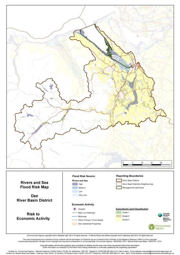
The River Dee RBD (shown in Figure ) covers an area of approximately 2,200km², the majority of
which is situated in north east Wales with the eastern part of the RBD in England. The River Dee is
approximately 110km long from its source in the Snowdonia National Park to where its estuary
discharges into Liverpool Bay.
From its source the River Dee flows eastwards to Llyn Tegid, an integral part of the River Dee
system. Upstream of Llyn Tegid the river is fast flowing in a narrow incised valley, whilst
downstream of the lake the valley bottom and natural floodplain opens out to approximately 1km
wide. The natural river system is modified through flow control at the Bala sluices located where
the River Dee is joined by the River Tryweryn. From Bala, the river flows north eastwards towards
Corwen where the River Alwen joins the Dee. There are two major reservoirs in the upper reaches
of the Alwen catchment, Llyn Brenig and Alwen Reservoir.
The River Dee continues in an easterly direction through Llangollen and downstream to Erbistock,
once again following a narrow incised valley. Between Erbistock and Chester the floodplain is flat
and very wide, with the main tributaries; Rivers Ceiriog, Clyweddog and Alyn, joining the Dee along
this reach.
Downstream of Chester Weir the river was canalised over 200 years ago and flood defences,
which are still maintained today, were constructed to protect land from tidal inundation. The River
Dee is normally tidal up to Chester Weir; however this boundary is exceeded for spring high tides
when tidal influence can affect river levels as far upstream as Shocklach, 15km upstream of
Chester Weir.
The Dee RBD comprises a range of landscapes including mountains, steep sided wooded valleys,
the plains of Cheshire and the mudflats in the estuary. The different topography within the Dee
River Basin District gives rise to different flooding responses. In the west the steep slopes give rise
to more rapid runoff and faster flooding responses, whereas runoff occurs more slowly on the
gently sloping land in the east.
Water
The River Dee is an important source of drinking water for nearly 3 million people in Wales and
North West England. Given the importance of maintaining this supply, opportunities to abstract for
other purposes are very limited and carefully regulated. Reservoirs in the upper part of the RBD
store water and regulate flow in the Dee. They sustain abstractions for public and industrial water
supply and modify flood response in the river. The strategic importance of the Dee for water supply
has led to it becoming one of the most regulated rivers in Europe and in 1999, the lower part of the
Dee was designated as the UK’s first Water Protection Zone.
There are 115 water bodies across the district comprising rivers, lakes, groundwater and the Dee
estuary. In 2009, 28% of the water bodies were at “good” status, this rose to 30% in 2013.
75 of 81Significant water issues identified for the Dee are; physical modifications, pollution from sewage
and waste water, pollution from rural areas and invasive non-native species.
Climate
UKCIP (UK Climate Impacts Programme) predicts that, by the 2050s, temperatures across Wales
could rise by 1.1 to 4.1°C. Annual average rainfall in Wales is predicted to remain roughly the
same as present, but there is likely to be a large difference in the patterns of summer and winter
rainfall. Increased winter rainfall is expected as a result of increased storminess, leading to
intense, but short-lived, rainfall events. Summer rainfall may decrease and short duration droughts
(12-18 months) are likely to become more frequent.
Future sea level rise along Wales’ coast is likely to result in more severe coastal erosion and
inundation events in low-lying coastal areas. The relative sea level rise around Wales is predicted
to be 36cm by the 2080s. These extremes impact on water related issues such as decreased
water availability and an increase in people and properties at risk from the effects of flooding.
Figure 3: The Dee River Basin District
Society and health
The population of the district is generally stable at around 458,000. Chester, Wrexham and
Deeside (the conurbation including Connah’s Quay, Queensferry, Pentre, Sandycroft and
Hawarden Airport) are the main urban areas in the RBD. Other significant towns in the RBD are
Bala, Llangollen, Corwen, Flint, Mold, Buckley, Whitchurch, Neston, Heswall and West Kirby.
There are some health inequalities evidenced by greater social deprivation in urban areas.
Significant housing growth along with creation of jobs and services is proposed in many towns.
Land use
The upland catchment is predominantly rural, with sheep farming on the poorer areas of grassland
and significant areas of commercial forestry. Frequent flooding in the lower Dee between Bangor-
on-Dee and Chester has resulted in very little urban development and the area is extensively used
for agriculture, particularly intensive dairy farming on the fertile land in and around Wrexham and
75 of 81on the Cheshire Plain. Arable farming dominates on the Wirral side of the estuary and around
Deeside and Sealand. Approximately 6% of the catchment is urban with Wrexham, Chester, and
Deeside being the main urban centres accounting for over 60% of the population. Canalisation of
the tidal section of the River Dee downstream of Chester has enabled urban development to take
place on both banks. Changes in land use within the catchment have led to physical changes to
the water environment and pollution from industry and diffuse rural pollution.
There is growing evidence that woodland measures can help to slow down or even reduce flood
flows, particularly within smaller catchments. Strategic tree planting and woodland management
can help reduce flood risk in a number of ways:
greater water use and interception by trees compared to other vegetation types helps to
reduce run-off volumes.
Woodland soils have greater capacity to absorb and store rainwater during flood events
due to their more open structure and the presence of root systems; this also aids
interception of overland flow from adjacent land;
The ‘hydraulic roughness' of trees and other woodland features can help to slow the flow of
overland flood water.
soils under woodland are also generally better protected from erosion risk, thereby reducing
delivery of sediment to watercourses and reducing pollutants in the water.
Therefore, ‘woodland measures’ for flood risk reduction include woodland creation – in the right
place and to the right design – and the installation of woodland features such as large woody
debris dams to both reconnect watercourses with already wooded riparian zones and floodplains
and to slow down flood flows.
The 2011 ‘Woodland for Water’ report detailed the evidence behind these conclusions. As a result
opportunity mapping was produced to help identify where targeted woodland measures could help
to reduce flood risk. Priority locations fall into three categories:
Floodplains – where hydraulic roughness from woodland cover slows the flow and encourages the
deposition of sediment;
Riparian zones – to intercept overland flow, protect river banks from erosion, and help slow
the flow of water;
Wider catchment planting – to protect sensitive soils from erosion, increase infiltration rates,
and intercept sediment in run-off from adjacent land.
While opportunity maps can identify priority catchments where woodland creation and
management can help reduce flood risk, it is important that woodland is located in the right part of
the landscape and then designed and managed appropriately in order to maximise their
contribution to reducing flood risk.
Land drainage for agricultural purposes was historically an important element of operational activity
in flood and coastal erosion risk management. Today the prime driver for investment in water
management for flooding and drainage is one of risk reduction to people and property, and for the
improvement of the environment. RMAs prioritise investment according to government policy, the
respective National Flood and Coastal Erosion Risk Management Strategies for England and
Wales and HM Treasury Green Book on economic appraisal. Government policy gives the highest
priority to lives and homes.
Economic activity
The economy of the River Dee RBD is characterised by:
• Forestry, tourism, cottage industries and hill farming in the upper Dee,
• Mainly agriculture (arable and pasture) in the lower Dee area
• Retail, commercial and industrial activities in and around Chester, Wrexham, Deeside and
tourism in Chester itself
75 of 81• Industrial development (manufacturing and commercial) adjacent to the Dee Estuary, on both
banks
Retail and distribution, health and education, and manufacturing and construction are the three
most significant employment sectors in the Dee RBD. Commerce is important, particularly in
Chester and the other urban areas. Tourism, farming and rural industries, and transport and
communications, although smaller, are key in sustaining rural communities. Fisheries and the Dee
cockle beds are also important to the local economy.
Recreation and tourism
The diversity of the landscape in the River Dee RBD offers a wide range of recreational activities
and opportunities which contribute to people’s quality of life and bring economic benefit from
tourism. The majority of visitors to the River Dee RBD enjoy informal recreation such as: walking,
camping, water sports, angling, horse-riding, mountain biking and rock climbing. Popular areas for
recreation include the Clwydian Mountains, River Dee Valley, and the lakes and reservoirs (Bala,
Celyn, Brenig and Alwen). Tourism is a major part of the local economy, especially within
Snowdonia National Park, Llangollen, Chester and Erddig near Wrexham.
Infrastructure
The RBD contains regionally important infrastructure, including railways (for example the Chester
to Holyhead mainline), primary roads (for example the A55 and A483), energy infrastructure,
canals, the Hawarden Airport, ports (including the Port of Mostyn) and industrial and commercial
development alongside the Dee Estuary. Recently there has been an increasing demand for
hydropower, with a number of sites being investigated.
Landscape
Agriculture and forestry dominate the upper reaches of the district and there are a variety of
landscape and settlement patterns. The upper catchment includes part of the Snowdonia National
Park and is predominantly rural in character. In the mid to lower catchment, the landscape
changes to rolling hills that gradually form the Cheshire Plain. The most tranquil areas of the
district are in the upper reaches with the mid to lower reaches being more disturbed by traffic and
settlements around Wrexham and Chester. In the lower reaches, urban development has had a
significant impact and many river channels and floodplains do not function naturally.
Biodiversity
The Dee RBD is hugely varied, from the mountains of Snowdonia to the internationally important
mudflats of the Dee Estuary. The importance of this habitat is reflected by a variety of international,
national and local nature conservation designations. There are 7 Special Areas of Conservation
(SACs), 3 Special Protection Areas (SPAs) and 3 Ramsar sites. The River Dee itself is a SAC and
Site of Special Scientific Interest (SSSI). The tidal Dee estuary is also a SPA and Ramsar wetland.
Many of the SSSIs (approximately 70) have close links with the water environment. Water bodies
and wetland areas within the district support a number of protected species (for example otter,
water vole) and priority species listed in the UK Biodiversity Action Plan (for example White-clawed
Crayfish and Freshwater Pearl Mussel). The highly modified nature of the Dee has lead to there
being 45 barriers to fish migration in the district. Invasive species in the RBD include Japanese
Knotweed, Himalayan Balsam and North American Signal Crayfish.
Many of the sites with environmental designations are affected by flooding and may be dependent
on periodic flooding to maintain their habitats and species. Fisheries are important in all the rivers
within the River Dee RBD and there are a significant number of stretches of river that are
designated under the Freshwater Fish Directive and are important for salmon and other species.
Cultural heritage
The River Dee RBD area has a diverse historic environment resulting from over 6000 years of
human settlement, including remnants of Neolithic and Bronze Age settlements in the River Dee
75 of 81You can also read