Town of Cambridge
Perry Lakes Management Plan
         2021-2031
←
→
Page content transcription
If your browser does not render page correctly, please read the page content below

Town of Cambridge
Perry Lakes Management Plan
2021-2031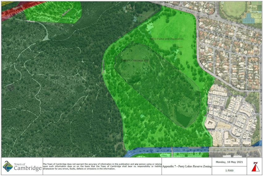
Perry Lakes Management Plan 2021 - 2031

Executive Summary

Situated between Perry Lakes Estate, Oceanic Drive, Bold Park and Underwood Avenue,
Perry Lakes Reserve in Floreat Western Australia is an iconic regional park with a rich history.
The land now occupied by Perry Lakes Estate was home of the Athletic Stadium used during
the Empire Games (Commonwealth Games) which were held in Perth in 1962.

Over the last thirty years the water levels in both the east and west lake have declined to the
point that both lakes are dry for many of the warmer months of the year. Perry Lakes water
levels are directly influenced by groundwater levels in the superficial (Gnangara Mound)
aquifer and directly impacted by changes in the water cycle. Significant impacts have been
observed through increased water abstraction for irrigation and public drinking water and
compounded by reduction in annual rainfall which is anticipated to further decline over the
coming decades due to climate change.

The Town is preparing to re-direct freshwater which is currently flowing out to sea north of
Floreat Beach through a Water Corporation stormwater drain (Herdsman Main Drain) to both
water bodies at Perry Lakes, this will provide localised groundwater recharge and increase
levels in both lakes during the warmer and drier months of the year. As a result of this
significant urban water management project there are a number of opportunities to
reinvigorate the site through increased use and improved biodiversity values by implementing
strategic management actions in this regional open space and conservation category wetland.

This Management Plan aims to assist the Town of Cambridge in managing and improving the
site over the next ten years to achieve the desired outcomes of the strategic community plan
which include activating major public places to generate the most value from the Towns
community facilities, education, access and management to enhance experience of the
natural environment while also increasing climate change resilience all achieved with a locals
first approach.

The Town of Cambridge acknowledges the Traditional Owners (Whadjuk Noongar) of the land
(Boodja) upon which we live and work and pay our respects to their Elders, past, present and
emerging.

                                                                             P a g e 2 | 66
Perry Lakes Management Plan 2021 - 2031

Table of Contents

1     Introduction ................................................................................................................................... 5
    1.1      Background ............................................................................................................................. 5

2     Management Plan Objectives ...................................................................................................... 6
    2.1      Site History .............................................................................................................................. 6
    2.2      Biophysical Environment ......................................................................................................... 6
    2.3      Environmental Threats ............................................................................................................ 6
    2.4      Management Recommendations ............................................................................................ 6
    2.5      Implementation Program ......................................................................................................... 6
    2.6      Strategic Direction ................................................................................................................... 6
    2.7      Community Stewardship ......................................................................................................... 6
    2.8      Educational Resource ............................................................................................................. 6

3     Environmental Issues ................................................................................................................... 7
    3.1      Water Levels ........................................................................................................................... 7
    3.2      Loss of Biodiversity ................................................................................................................. 7
    3.3      Conservation ........................................................................................................................... 7
    3.4      Water Quality........................................................................................................................... 7
    3.5      Weeds ..................................................................................................................................... 7
    3.6      Fauna ...................................................................................................................................... 7
    3.7      Trees ....................................................................................................................................... 7
    3.8      Education ................................................................................................................................ 7

4     Recreational Issues ...................................................................................................................... 8
    4.1      User Conflict ............................................................................................................................ 8
    4.2      Accessibility ............................................................................................................................. 8
    4.3      Public Safety ........................................................................................................................... 8
    4.4      Activation ................................................................................................................................. 8

5     Strategic Context .......................................................................................................................... 8
    5.1      Tenure and Zoning .................................................................................................................. 8
    5.2      Town of Cambridge Strategic Framework .............................................................................. 8
    5.3      Legal Framework .................................................................................................................... 9

6     Site History .................................................................................................................................. 10
    6.1      Indigenous Land Use ............................................................................................................ 10
    6.2      Post-European Land Use ...................................................................................................... 11

7     Regional Setting .......................................................................................................................... 13
    7.1      Location and General Description ......................................................................................... 13

                                                                                                                             P a g e 3 | 66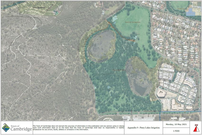
Perry Lakes Management Plan 2021 - 2031

    7.2      Regional Characteristics ....................................................................................................... 13
    7.3      Surrounding Land Use .......................................................................................................... 14

8     Existing Biophysical Environment ............................................................................................ 15
    8.1      Climate .................................................................................................................................. 15
    8.2      Rainfall .................................................................................................................................. 15
    8.3      Temperature .......................................................................................................................... 16
    8.4      Changing Climate .................................................................................................................. 16
    8.5      Wind ...................................................................................................................................... 16
    8.6      Fire season............................................................................................................................ 17
    8.7      Geology and Geomorphology ............................................................................................... 17

9     Water Resources ......................................................................................................................... 19
    9.1      Hydrogeology ........................................................................................................................ 19
    9.2      Hydrology .............................................................................................................................. 19

10    Flora .............................................................................................................................................. 25
    10.1     Original Vegetation ................................................................................................................ 25
    10.2     Existing Vegetation Condition ............................................................................................... 25
    10.3     Vegetation Types .................................................................................................................. 27
    10.4     Conservation Significant Ecological Communities ................................................................ 28
    10.5     Flora Diversity ....................................................................................................................... 28
    10.6     Introduced Flora .................................................................................................................... 28

11    Fauna ............................................................................................................................................ 29
    11.1     Fauna Diversity ..................................................................................................................... 29
    11.2     Conservation significant fauna .............................................................................................. 29
    11.3     Birds and other water dependent species ............................................................................. 29
    11.4     Aquatic Invertebrates ............................................................................................................ 30

12    Management Strategies .............................................................................................................. 31
    12.1     Water Management ............................................................................................................... 31
    12.2     Flora Management ................................................................................................................ 32
    12.3     Fauna Management .............................................................................................................. 34
    12.4     Cultural and Recreational Facility Management ................................................................... 36

13    Implementation Program ............................................................................................................ 38

14    Appendices .................................................................................................................................. 49

15    References ................................................................................................................................... 66

                                                                                                                              P a g e 4 | 66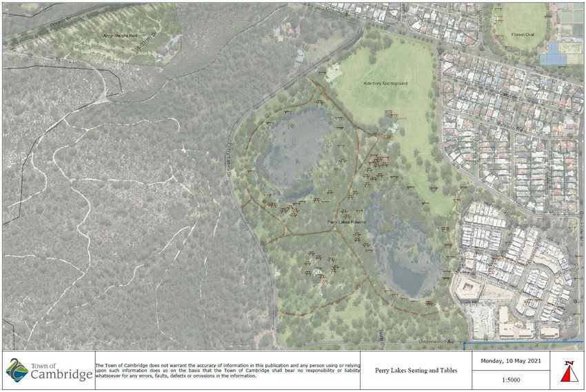
Perry Lakes Management Plan 2021 - 2031

1 Introduction
1.1   Background

Perry Lakes Reserve is located approximately seven kilometres west of Perth CBD and covers
a total of approximately eighty hectares. The Reserve is bounded by Oceanic Drive, Alderbury
Street, Meagher Drive, Underwood Avenue and Perry Lakes Drive (see Appendix 1). The site
encompasses two lakes covering approximately 12.6 hectares and surrounding parkland. The
Reserve offers a range of passive recreation facilities including shaded picnic areas, paths,
playgrounds, exercise facilities, barbecues and public toilets (see Appendices 2 – 5).
Alderbury Reserve sits in the northern section of the site and includes playing fields, used for
cricket and hockey, a dog exercise area and a skate park (see Appendix 6).

The lake environment consists of a range of vegetation types including Closed to Open
Sedgeland, submerged Eucalyptus Woodland featuring Eucalyptus rudis (flooded gum) and
Melaleuca rhaphiophylla and clumps of Melaleuca species on lake banks. There are stands
of open and closed Eucalyptus Forest dominated by Eucalyptus rudis, Agonis flexuosa and
Melaleuca rhaphiophylla. The area surrounding the lakes is parkland and predominantly
consists of open woodland with Eucalyptus gomphocephala (Tuart), Eucalyptus rudis
(Flooded Gum), Agonis flexuosa (WA Peppermint), a number of Melaleuca species
(Paperbarks) and introduced Pinus species (Pines).

The vegetation within and surrounding the lakes has become highly modified due to a wide
range of land uses since European settlement. The lakes have become isolated with
increasing development and associated loss of vegetation. Clearing and development has
resulted in changed lake hydrology and subsequent terrestrialisation of the lakes, altered
vegetation composition and structure, and increased weed invasion.

This Management Plan updates the original Management Plan developed for Perry Lakes and
Alderbury Reserves in 2001. The plan describes the existing physical and biophysical
environment and identifies and assesses the impacts of current land uses of the Reserves.
This plan helps inform the management objectives, strategies, monitoring and reporting
required for effective environmental management of the Reserves encompassing the two
lakes and surrounding parkland.

                                                                             P a g e 5 | 66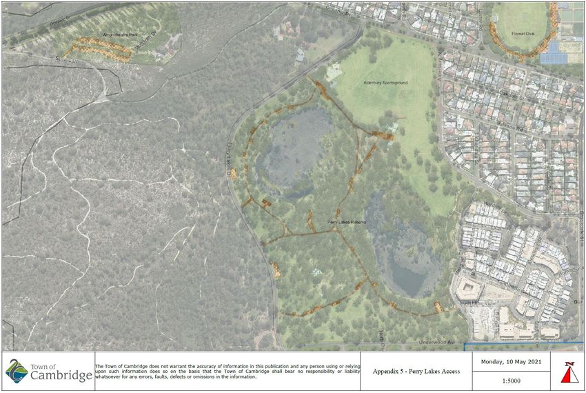
Perry Lakes Management Plan 2021 - 2031

2 Management Plan Objectives
Taking into consideration the goals, strategies identified in the Community Strategic Plan,
there is a need to align the management plan objectives desired over the next ten years.

The objectives of the Perry Lakes Reserve Management 2021-2031 include:

2.1   Site History
Provide background to Perry Lakes Reserve including the indigenous and European history;

2.2   Biophysical Environment
Describe the biophysical environment, flora and fauna of the reserve and provide baseline
data to inform future environmental planning;

2.3   Environmental Threats
Describe the key environmental threats to the reserve and their impact on biodiversity and
recreational values;

2.4   Management Recommendations
Provide management recommendations to address environmental threats and improve the
biodiversity and recreational values of the reserve

2.5   Implementation Program
Present an implementation program which incorporates the management recommendations
over a five year period;

2.6   Strategic Direction
Provide strategic direction for future works through the development of a Masterplan;

2.7   Community Stewardship
Encourage community stewardship of the site through the Adopt a Park program and the
establishment of a Friends of Perry Lakes group; and

2.8   Educational Resource
Promote Perry Lakes Reserve as a key environmental destination and educational resource
within the Town.

                                                                           P a g e 6 | 66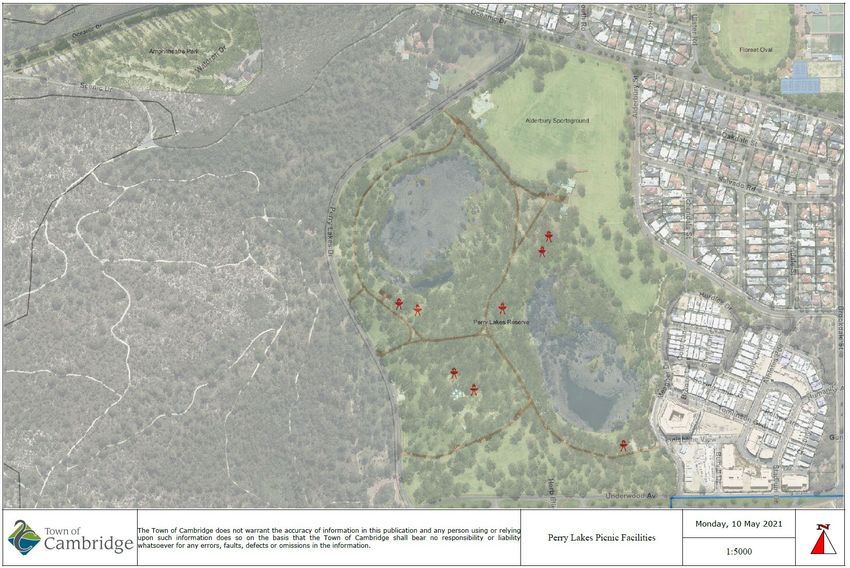
Perry Lakes Management Plan 2021 - 2031

3 Environmental Issues
The major environmental issues identified at Perry Lakes and Alderbury Reserves are
summarised below.

3.1   Water Levels
The drop in water levels in both lakes resulting from the decline in groundwater levels of the
Superficial Aquifer (Gnangara Mound);

3.2   Loss of Biodiversity
The impact of dry lakes on the aesthetics of the site (Reduction in biodiversity of the flora and
fauna);

3.3   Conservation
Conservation of lake ecology and biological diversity in the area;

3.4   Water Quality
Water quality issues related to inputs of nutrients, contaminants and the potential high
bacterial levels associated with the large waterbird population on the lakes;

3.5   Weeds
Invasive weeds impacts on both lakes, fringing vegetation and associated natural areas;

3.6   Fauna
Conservation of fauna including birds, turtles, frogs and invertebrates;

3.7   Trees
Tree management; and

3.8   Education
School and community environmental education and awareness.

                                                                              P a g e 7 | 66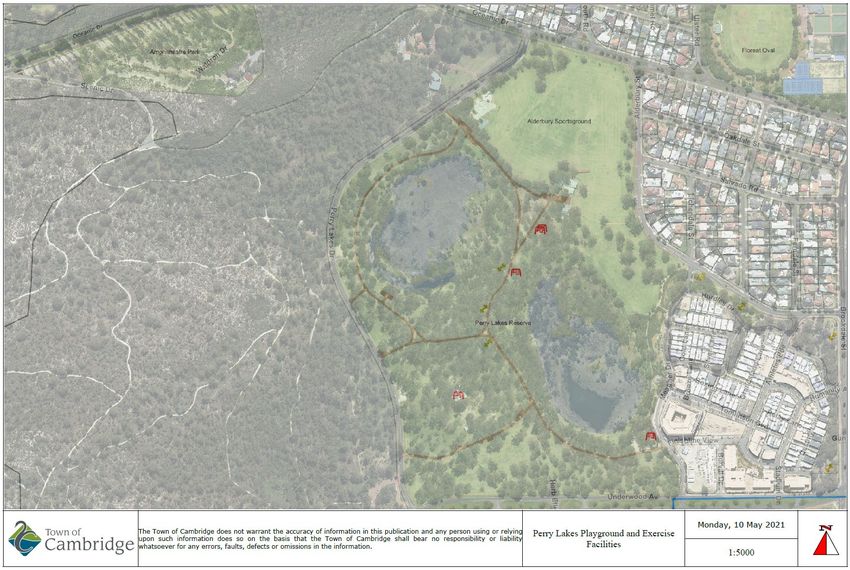
Perry Lakes Management Plan 2021 - 2031

4 Recreational Issues
4.1   User Conflict
Reducing the conflict between vehicles, pedestrians, cyclists and other park users;

4.2   Accessibility
Ensuring accessibility compliance of paths and facilities for users of all ages and abilities
(multigenerational) including wheelchairs, scooters, prams, skateboards, bikes and walking
frames;

4.3   Public Safety
The general safety and security of the users of the site and consideration of Crime Prevention
Through Environmental Design (CPTED) principals; and

4.4   Activation
Increased activation of the site for other user groups as determined through public consultation
and stakeholder engagement.

5 Strategic Context
5.1   Tenure and Zoning

The Town of Cambridge is the registered title holder of the fee simple estate of Perry Lakes
Reserve. It consists of Lot 720 within the Town Planning Precinct P2 – Reabold. The legal
description is, Lot 720, parcel 21069, Volume 2138 and Folio 16. The site covers an area of
584,752m2 (58.84ha). Perry Lakes Reserve is zoned Parks and Recreation in the Metropolitan
Region Scheme (MRS) (see Appendix 7).

It is also part of Bush Forever Site No 312 which covers 361.7ha of land primarily including
Bold Park and Perry Lakes, stretching from The Boulevard in the north, Elphin Drive, Oceanic
Drive, Alderbury and Brookdale Streets to the east, Underwood Avenue, Stephenson Avenue
and Rochdale Road to the south and West Coast Highway, Oceanic Drive and Kalinda Drive
to the west.

Bold Park is located to the west of the site and is 437 hectares of Class A reserve. The eastern
side of the reserve is bounded by the Perry Lakes Estate (Former 1962 Empire Games
Stadium) which is zoned residential. Alderbury Reserve is located to the north and is zoned
Parks and Recreation in the MRS. The suburb of Floreat is located north of Alderbury Reserve
and is zoned residential. The Bendat Basketball Centre and WA Athletics Stadium are located
on the southern side of Underwood Avenue and also zoned Parks and Recreation in the MRS.

5.2   Town of Cambridge Strategic Framework

The following goals and strategies of the Town’s Strategic Community Plan 2018-2028 align
with the objectives of the Perry Lakes Management Plan.

Goal 1: A sense of community, pride and belonging

       1.1     Encourage and support participation in a range of public activities and events
       where residents can gather and interact.
       1.2     Promote our strong community identity and focus our responses on the needs
       of local residents, businesses and ratepayers.

                                                                             P a g e 8 | 66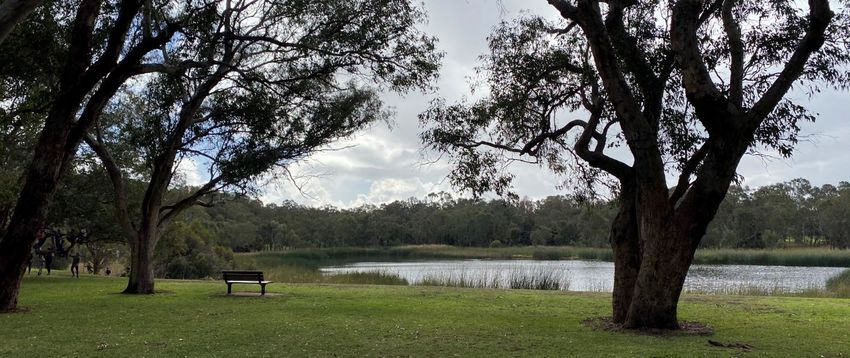
Perry Lakes Management Plan 2021 - 2031

Goal 2: Quality local parks and open spaces for the community to enjoy

       2.1      Adopt a more strategic and coordinated approach to the planning of our parks
       and greenspaces recognising their diverse roles and local community preferences.
       2.2      Improve the maintenance and provision of amenities in our local parks and
       district open spaces reflecting local values and priorities and the broader regional
       demand on facilities.

Goal 3: An active, safe and inclusive community

       3.1     Focus on improving and expanding those places where community groups
       interact to encourage greater participation.
       3.3     Encourage a range of activities that better align with the diverse needs of
       ratepayers of all ages, cultures and abilities.
       3.4     Act to create and maintain safe, friendly and open environments that residents
       can access and enjoy.

Goal 7: The Town is environmentally responsible and leads by example

       7.1     Manage our bushland areas to enhance and protect conservation values and
       protect our native animals and plant species
       7.2     Optimise our use of ground water and improve the efficiency of our clean water
       consumption
       7.5     Promote our environmental assets and opportunities and recognise the
       impacts of climate change in our strategies.

Goal 8 A community that embraces environmentally responsible practices

       8.1    Encourage the community to self-manage minimising energy consumption,
       water use, emissions and waste.

5.3   Legal Framework

Perry Lakes is managed within a statutory and policy framework. The applicable legislation,
policies and guidelines are summarised in Appendix 8.

                                                                          P a g e 9 | 66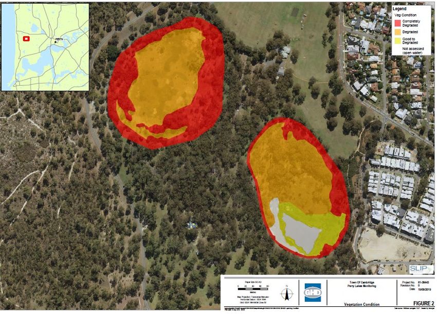
Perry Lakes Management Plan 2021 - 2031

6 Site History
6.1   Indigenous Land Use

Like all wetlands across the Swan Coastal Plain, Perry Lakes is believed to be an important
place to the Whadjuk Noongar people. “The area now defined as Perry Lakes has been
identified by the Department of Aboriginal Affairs, Aboriginal Heritage Inquiry System as
Heritage Place 3735 as a former camp and hunting place. As a wetland it is logical this place
was used by the Whadjuk Noongar peoples for a range of functions prior to and following
establishment of the Swan River colony in 1829.” (see Appendix 7).

The Noongar believed that the Swan River (Derbal Yerrigan) and wetlands such as Perry
Lakes were created in the Cold Times (Nytting) by the Rainbow Serpent (Wagyl) as it entered
and exited the country (Boodja). The water flowed from one water course to another
connecting water across the landscape.

Perry Lakes would have been an important meeting and camping place where the Whadjuk
Noongar people would stop to eat and rest if they were travelling. It was a very rich place with
plentiful vegetation and animals. It didn’t belong to any one group. It was a shared place. The
lakes were a significant hunting ground for ducks, swans, cockatoos and long necked turtles.
Kangaroo and emu were also hunted in the surrounding woodland using spears made from
Kunzea ericafolia or glabrescens (Spearwood). Melalueca and Eucalyptus were used to build
mia-mias while reeds were useful snorkels and provided edible tender shoots

The Noongar People recognise six distinct seasons in South Western Australia which reflect
the times of certain foods or locations for hunting. These six seasons are shown below in
figure 1.

Figure 1 – Noongar six seasons, source - https://www.australiassouthwest.com/south-west-
inspo/six-seasons-south-west

                                                                            P a g e 10 | 66
Perry Lakes Management Plan 2021 - 2031
6.2 Post-European Land Use
Perry Lakes is a registered heritage place (No 9008) with the State Heritage Council.
“Henry Trigg, a carpenter and master builder from Gloucester, England arrived in the new
colony of Western Australia in 1829. In I834, Trigg was granted 500 acres of land, which lay
south of modern day Grantham Street, stretching from Floreat to the coastal sand hills. The
western boundary of Trigg's land ran along the top of a limestone ridge. As a builder, Trigg
recognised the value of this limestone outcropping and set up a quarrying and lime burning
business. Trigg's business which became known as the 'Limekilns' prospered.
In 1839, Trigg purchased neighbouring land to the south, including what is now Perry Lakes
and One Tree Hill, (now known as Reabold Hill). In the same year, Trigg was appointed
Superintendent of Public Works, and in this role was responsible for overseeing the erection
of many early government buildings in Perth.
In 1844, Walter Padbury, a pastoralist, acquired 426 acres of land adjacent to Trigg's property
and later purchased Trigg's land including the Limekilns business for 2350, forming a 1,234
acre landholding which became known as the 'Limekilns Estate'. For the next 20 years
Padbury built the Estate into a successful property, including the retention of the quarrying
operations. At the height of operations, more than 50 men were employed at the quarry and
lime kiln site.
In 1869, brothers Henry and Somers Birch purchased the Limekilns Estate from Walter
Padbury for £1,000. On 1 November 1875, during their ownership of the property, the explorer
Ernest Giles arrived in Perth after his 2,500 mile journey from Port Augusta. His camels were
rested at the Limekilns Estate and later in the 1890s, the Limekilns Estate served as a
temporary quarantine station for camels imported to Western Australia to provide transport to
the goldfields, with a lake now within Bold Park becoming known as Camel Lake.
The Estate remained in the Birch's ownership until, 1880 when it was purchased by Joseph
Perry for the sum of £1300. During his ownership, Perry kept the Quarry and limekilns in
operation. Many of Perth's early public buildings, including the foundations of the Perth Town
Hall (1870) were constructed using limestone from the quarry and kilns.
In 1880, a portion of the Limekilns property was rented to Charles Ball who offered to supply
lime which was described as the most superior in the colony, from lime kilns of 30 years
standing. Private quarrying ceased operation in 1906 and the Limekilns Quarry (Quarry
Amphitheatre) remained disused for many years.
Changes to the rural nature of the area came about with the subdivision of land owned by the
Catholic Church in 1911. This subdivision was called the Church Lands Estate, and the first
house was constructed in 1912.
In 1917, the Perth City Council purchased the 1290-acre Limekilns Estate from Perry for
£18,000 and it linked to the Endowment Lands bestowed on the Perth City Council by the
State Government in 1902. In January 1918, the Limekilns Estate was included within the
boundaries of the City of Perth, and adjoined a further 2281 acres of Endowment Lands. The
City envisioned opening out the quarries and using the limestone in the construction of city
roads but also setting a portion of the land aside for a public park on the site of
Perry's couch paddock and One Tree Hill (Reabold Hill).
P a g e 11 | 66Perry Lakes Management Plan 2021 - 2031
The exact date that the municipal Quarry ceased operation is not known, but it is likely that
operations ceased in the 1920s with the beginning of the development of the area for housing.
During the middle decades of the 20th century the quarry was unused and largely
inaccessible.
In 1919, One Tree Hill was renamed Reabold Hill after F. R Rea, the Mayor of Perth at the
time the property was acquired by the City of Perth and W. E. Bold, the town clerk. By this
time the lone Tuart tree that had previously sat atop the 286 ft. high hill, and given the place
its name had disappeared.
In 1925, an area of land of approximately 1000 acres was set aside as a place of recreation
and was named Bold Park in honour of William Ernest Bold (1873-1953), the retiring town
clerk. Other sources have designated that the naming occurred in 1936. Perry Lakes was
included in the original boundaries of Bold Park when it was established by the City of Perth.
Perry Lakes in its current form dates from 1962 when the area was landscaped in association
with the construction of Perry Lakes Stadium and associated sporting tracks and facilities for
the 1962 Empire Games. The Perry Lakes Stadium was demolished from 2010 to 2012 and
is now being developed for residential occupancy.
The Perry Lakes Reserve has been redeveloped as part of the Perry Lakes redevelopment
project. New facilities for passive and formal recreation have been built on the site included a
skate park and a nature playground.
Long term visitors to the Perry Lakes reserve have been groups of scouts and guides. The
current Cambridge Scout and Guide Hall was built c2005 however prior to that fire pit has
been located at the site for many years. Aerial photographs indicate the fire pit was present at
the current location from the 1970s although further information is required to determine its
date of construction.
A commemorative sculpture is located within the grounds that honours 75 years of Scouting
which occurred in 1982. The sculpture also acknowledges the 1979 world wide jamboree
which saw 12000 scouts camp at the site. The Australian Scout Jamboree was again held on
the site in 1994/95. The Town of Cambridge have instigated a management plan for the
reserve with a particular focus on maintaining water levels which have been observed as
declining in recent decades.” (InHerit 2021)
P a g e 12 | 66Perry Lakes Management Plan 2021 - 2031
7 Regional Setting
7.1 Location and General Description
Perry Lakes Reserve and Alderbury Reserve are located approximately 7 km to the west of
Perth and cover a total area of approximately 80 hectares. Close to 12.6 hectares of this area
is covered by the two lakes, West Lake being 5.9ha and East Lake being 6.7ha. The Reserves
constitute a moderately developed, recreational parkland in the suburb of Floreat. The
Reserves are bounded by Oceanic Drive to the north, Meagher Drive and Alderbury Street to
the east, Perry Lakes Drive and Bold Park to the west and Underwood Avenue to the south.
The landscape has parkland character dominated by the two lakes and surrounded by trees
with no understorey. Recreational facilities within the Reserves include picnic areas,
barbecues, playgrounds and fitness equipment and a sports ground. The site is serviced by
numerous roads and car parking facilities to provide easy access for vehicles. The park
provides many benefits to the surrounding urban environment including:
• Visual Relief – by breaking up the uniform areas of suburbia;
• Recreation – by enabling large numbers of people to pursue many kinds of recreational
pursuits such as walking, jogging, cycling, nature studies, picnics;
• Conservation – the lakes and overall structure of the parkland provide a valuable habitat
for an abundance of wildlife and plants; and
• Education – the landscape character provides a biological laboratory accessible to
schools, universities and the general public.
7.2 Regional Characteristics
The wetlands of the Perry Lakes area were originally ephemeral like most wetlands of the
Swan Coastal Plain. However during the era of tree clearing for firewood, construction and
agricultural land, the groundwater levels increased around the wetlands. In 1962 landscaping,
dredging and drainage works associated with the construction of Perry Lakes Stadium for the
1962 Commonwealth Games resulted in permanent water in the lakes.
Since the 1970’s over abstraction of groundwater from the Gnangara Mound (shallow aquifer)
for irrigation and drinking water has resulted in a drying wetland. Extensive weed invasion and
a drying climate has displaced native species and contributed to further environmental decline.
The East and West Lakes form the central feature of Perry Lakes Reserve. These lakes are
semi-permanent, freshwater lakes which are located on the Swan Coastal Plain and are
surface expressions of the shallow aquifer. Seasonal fluctuations in the height of the water
table result in corresponding changes in the water levels of the lakes. In order to provide a
range of water levels and depths in the lakes, West Lake has previously been allowed to dry
out naturally during summer. Groundwater has been pumped into East Lake to maintain a
year round water supply for local fauna. The diversion of water from the Herdsman Main drain
will provide water in both lakes well into summer.
Historical data suggests that the Reserve was originally part of a natural wetland system. The
current landscape consists of a mixture of vegetation including benthic algae, aquatic and
semi-aquatic plant life including, sedges, reeds, trees and grasses. The fauna of the lakes
includes a wide range of water birds (both indigenous and non-indigenous species), turtles,
frogs, fish and aquatic invertebrates.
P a g e 13 | 66Perry Lakes Management Plan 2021 - 2031
Perry Lakes Reserve provides an environment for numerous recreational pursuits, many
people visit the park each year, utilising the existing facilities available. Some of these activities
include walking, running, cycling, bird watching, picnics, barbeques, parties and events which
have included the Scouting Jamboree and Garden Week.
Organised sporting activities including cricket, hockey, skateboarding, dog exercise and both
formal and informal fitness classes, are held on the active space known as Alderbury
sportsground to the north of the site.
7.3 Surrounding Land Use
Major surrounding land uses include a residential area to the north and east of the Reserve,
Bold Park which is an A Class reserve located to the west of Perry Lakes (Perry Lakes Drive
separates the Reserve from Bold Park), and CSIRO, the State Basketball Stadium and HBF
Stadium south of the reserve.
P a g e 14 | 66Perry Lakes Management Plan 2021 - 2031
8 Existing Biophysical Environment
8.1 Climate
Perth has a Mediterranean climate characterised by hot dry summers and mild, wet winters.
Mean temperature and rainfall data for the period between 1994 and 2020 is provided below.
Jan Feb Mar Apr May Jun Jul Aug Sep Oct Nov Dec Annual
Mean 19.1 13.4 19.7 35.2 87.7 127.8 144.5 125.5 82.8 38.8 21.7 10.6 733.2
Rainfall
(mm)
Mean Max 31.2 31.6 29.6 25.9 22.3 19.5 18.4 19.1 20.4 23.4 26.8 29.3 24.8
Temp (oC)
Mean Min 18.1 18.4 16.8 13.8 10.4 8.6 7.9 8.3 9.5 11.6 14.4 16.4 12.8
Temp (oC)
Figure 2. Mean Rainfall and Temperature Data for the Perth Area (1994 – 2020)
Source: Bureau of Meteorology.
8.2 Rainfall
The pattern of rainfall is strongly seasonal with most rainfall occurring between May and
October and the highest levels recorded in June and July. The average annual rainfall is 733.2
mm and has steadily declined since last century.
160
140
120
Rainfall (mm)
100
80
60
40
20
0
Jan Feb Mar Apr May Jun Jul Aug Sep Oct Nov Dec
Month
Figure 3. Mean Monthly Rainfall for Perth: 1994 – 2020
Source: Bureau of Meteorology
P a g e 15 | 66Perry Lakes Management Plan 2021 - 2031
8.3 Temperature
Maximum temperatures in summer average 30.7oC while the minimum temperatures average
17.6oC. The maximum temperatures for winter average 19oC while the minimum
temperatures average 8.3oC. Temperatures have gradually increased over the last century.
35
30
25
Temperature oC
20
15
10
5
0
Jan Feb Mar Apr May Jun Jul Aug Sep Oct Nov Dec
Month
Figure 4. Mean Monthly Maximum Temperature for Perth: 1994 – 2020
Source: Bureau of Meteorology, 2020
8.4 Changing Climate
Between 1910 and 2013 the average annual temperature in the south west of Western
Australia has increased by 1.1oC (Department of Primary Industries and Regional
Development, 2020). There has also been an increase in the number of hot spells (heatwaves)
which the Bureau of Meteorology define as three or more consecutive days where the
maximum and minimum temperatures are unusually high for the location (Department of
Primary Industries and Regional Development, 2020). In Perth the frequency of heatwaves
has generally increased. Between 1981 and 2011 the annual average intensity of hot spells
increased by 1.5oC and the annual average number of heatwave days increased by three
(Department of Primary Industries and Regional Development, 2020).
Since 1970 there has been 20% decline in May to July rainfall in the southwest of Australia
(CSIRO, 2020). This is also consistent with the 20% reduction in annual rainfall totals during
the same period. The resulting outcome has been reductions of up to 80% in both streamflow
and groundwater recharge of the superficial aquifer.
Reduced water availability associated with the hotter and drier climate in the south west of
Western Australia is placing greater stress on native flora and fauna. Several of the
management actions in this plan aim to address declining water availability and improve
ecosystem resilience.
8.5 Wind
The winds are strongest during summer with 51% of winds in December exceeding 20km/hr
at 1500 hours compared with only 20% in May and 25% in June, July and August (Bureau of
P a g e 16 | 66Perry Lakes Management Plan 2021 - 2031
Meteorology, 2020). The typical summer pattern is strong easterly winds in the morning
swinging to a strong south-westerly wind or sea breeze in the afternoon.
In February the ocean and land temperatures are closer resulting in a weaker sea breeze or
no sea breeze at all. In late summer, dissipating tropical cyclones may also pass through Perth
bringing rain and strong winds. During winter winds are generally lighter, the stronger westerly
and north-westerly winds are associated with rain bearing depressions.
8.6 Fire season
The fire season typically extends from September to early May. High to extreme fire danger
periods occur from April to October. Lightening associated with summer thunderstorms can
be an ignition source of bush fires. The combination of hot, dry, windy and lightening prone
weather can result in severe fire risk in the region.
Perry Lakes is not considered a designated Bushfire Prone Area by the Department of
Planning, Lands and Heritage due to the understory of irrigated grasslands within the site.
However the extreme western edge is impacted by Bold Park which is a designated Bushfire
Prone Area.
8.7 Geology and Geomorphology
Perry Lakes is located on the Swan Coastal Plain which lies on the eastern, onshore edge of
the Perth Basin. The basin contains approximately 13,000m of Permian to Quarternary aged
sedimentary rock. The uppermost plain formations are late Tertiary and Quarternary,
comprising sand, limestone and interbedded silt and clay, up to 100m thick.
The Swan Coastal Plain is characterised topographically by a series of distinct dunal systems
aligned approximately north-south and extending from the coast to the Darling Scarp. The
Quindalup and Spearwood Dune Systems lie closest to the coast, with the Bassendean Dune
System further to the east. Wetlands occur in the intertidal depressions within and between
these systems. Perry Lakes and Alderbury Reserves lie in an interdunal depression on the
Spearwood Dune System.
Churchwood and McArthur (1980) identified the following soil types in the area:
1. Karrakatta – undulating landscape with deep yellow sands over limestone
2. Cottesloe – low hilly landscape with shallow brown sands over limestone, much exposed
limestone.
Department of Agriculture and Food (DAFWA 2008) identified three soil subsystems at the
site:
1. Peaty clay – dark grey and black, soft, variable organic content, some quartz sand in
places or lacustrine origin.
2. Sand – pale and olive yellow, medium to coarse-grained, quartz, traces of feldspar,
moderately sorted and of residual origin.
3. Lake – Spearwood wet, lake phase.
The superficial sediments of the Spearwood Dune System comprise aeolian calcernite
(reverted Tamala Limestone) and are underlain be leached yellow sands of the Tamala
Limestone. These sediments are typically pale brown to yellow calcernite, becoming more
calcareous at depth. The sediments may yield large quantities of high quality groundwater and
often have a capacity to absorb some contaminants, particularly phosphorus.
P a g e 17 | 66Perry Lakes Management Plan 2021 - 2031
The Reserves lie at an altitude of approximately 6m AHD with a ground surface that is gently
undulating with slopes of mostly less than 1o.
Figure 5. Soils of the Swan Coastal Plain
Source: Department of Agriculture and Food WA 2015
P a g e 18 | 66Perry Lakes Management Plan 2021 - 2031
9 Water Resources
9.1 Hydrogeology
The Quaternary sediments of the Swan Coastal Plain form a heterogeneous, unconfined
aquifer which varies in composition both vertically and laterally. The aquifer is recharged from
rainfall and drains laterally to the ocean and the Swan/Canning River System, and vertically
to the underlying deep Leederville aquifer. Groundwater also leaves the shallow aquifer by
evapotranspiration and extraction via irrigation bores. The combination of topography,
sediment thickness and drainage has resulted in the formation of two superficial groundwater
mounds, the Gnangara Mound and the Jandakot Mound within the Perth urban area. Both
mounds have contributed to Perth’s water supply.
Perry Lakes Reserve lies on the southern boundary of the Gnangara Mound. Regional
groundwater flow is to the southwest at an average rate of 50-100m per year. Seasonal water
table fluctuations in the vicinity of Perry Lakes occur over the range of approximately 2.5m
AHD and 4.0m AHD.
When the water table is higher than the water level of the lakes due to significant rainfall
events, groundwater percolates into the lakes along their perimeters and through the lake
bottom sediments. When the water level in the lakes is higher than the water table, water
discharges from the lakes to the ground water system. The magnitude and direction of this
flux depends upon the relative elevations of the lake surface and the local water table, the
permeability of the lake bed and adjoining formations and the presence of low permeability
layers in the superficial aquifer.
Ground water levels as expressed in this groundwater dependant wetland have decreased
over time with pressure from increased extraction and a drying climate.
9.2 Hydrology
Lake Hydrogeology
The Perry Lakes are shallow semi-permanent, freshwater lakes located in a topographical
depression within grey and yellow quartz sands of the Swan Coastal Plain. The lakes are
surface expressions of the shallow groundwater table. East Lake has a surface area of
approximately 67,500m2 (6.75Ha) while West Lake has an area of approximately 59,375m2
(5.94Ha).
The lakes are a modified remnant of a wetland which existed prior to European settlement and
originally consisted of four distinct wetlands. Aerial photographs taken in 1953 indicate that
the lakes contained abundant emergent vegetation and experienced a regular seasonal cycle
of drying and filling (Townley et al., 1995).
During very wet years West Lake expanded to cover the flats which now form Alderbury
Reserve and East Lake flooded to an area now occupied by the Perry Lakes Estate.
Permanent water only existed in the lakes after 1962 when dredging was conducted during
the construction of the Perry Lakes Stadium (Townley et al., 1995). In the last 30 years the
impact of a drying climate has resulted in seasonal drying of West Lake. The permanent water
in East Lake is maintained using bore water.
P a g e 19 | 66Perry Lakes Management Plan 2021 - 2031
Perry Lakes are considered to be flow-through lakes (groundwater dependant) and represent
the most common form of wetland found on the Swan Coastal Plain. The ground water of a
flow-through lake flows towards the lake on the up gradient side, generally discharging from
the aquifer through the lake bed, close to the up gradient shore. On the down gradient side of
the lake, water is recharged to the aquifer through the lake bed, again close to the down
gradient shore. The groundwater in this area moves in a south westerly direction.
The Swan River intercepts the Indian Ocean at an oblique angle. Groundwater entering the
Perry Lakes sector of the superficial aquifer does so across an extremely small aquifer section
between Herdsman Lake and Lake Monger. This water ultimately leaves the aquifer across a
much larger section represented by the constant head boundary comprising the Indian Ocean
and Swan River estuary. The Perry Lakes sector is therefore a zone of relatively low
groundwater flow velocity and low water table gradients (Turner and Rich, 1999).
Water levels in the lakes reflect the groundwater level in the aquifer close to the lakes. In the
past when the lakes contained water throughout the year they appear to have functioned as
permanent flow-through lakes. Recent declines in ground water levels with increased
extraction and a drying climate have resulted in the lakes drying in late spring until
replenishment from winter rains.
The level in East Lake is currently maintained between 2.87 and 2.9m AHD through bore water
input, however the future Herdsman Drain diversion will reduce the need for this reliance and
result in a managed AHD of up to 3.8m in both lakes through an average input of approximately
5GL/day (except during periods of low flow in summer). This depth is regarded as ideal for
managing water quality impacts. It will also ensure that the island (AHD 4.0m) in each lake is
not inundated and can be used as by local fauna as a refuge.
Surface Catchments and Drainage
The lakes drain a surface catchment covering a total of 459.2ha. Six drains discharge storm
water in to the lakes from the surrounding catchment area. The catchment of East Lake
generates some surface runoff. Four stormwater outlets carry runoff from sealed areas in the
carparks of CSIRO and some suburban streets of Floreat. The majority of paved surfaces in
the East Lake catchment including Stephenson Ave, Brockway Road and Underwood Ave are
drained by the Water Corporation Subiaco Main Drain which runs to the south of Stephenson
Avenue and do not contribute runoff to the lakes (Dames and Moore, 1992).
The West Lake catchment contains a greater area of paved surfaces than that of East Lake
including Oceanic Drive and suburban streets in Floreat. The stormwater from these areas
enters the lake via a stormwater drain at the northern end. Another smaller drain carries runoff
from Perry Lakes Drive into the lake at its western side.
P a g e 20 | 66Perry Lakes Management Plan 2021 - 2031
Figure 6. Catchment areas for Perry Lakes
Source: Town of Cambridge
Historical Water Levels
Significant hydrogeological modification of the lakes commenced in the 1950s when open
storm water drains were dug into the lakes from new housing estates in Floreat and Wembley.
This was followed by the construction of the sports stadium for the 1962 Commonwealth
Games. As part of the development the lakes were extensively modified which included
dredging and bank reclamation. Extensive grassed areas were established around both lakes
and the first bores were established in 1962 for lawn irrigation (Turner and Rich, 1999).
The modifications were carried out at a time of very high groundwater levels. Aerial images
taken in 1962 show two oval sheets of water with distinct banks and no emergent vegetation.
The lack of safe nesting areas for water birds prompted further modifications which included
construction of an island in East Lake around 1984 and deepening and construction of an
island in West Lake in the early 1980s.
Drought during the 1970s contributed to a widespread decrease in groundwater levels
throughout Perth. Portions of the lake beds became exposed over summer. A drying climate
has contributed to an ongoing decline in groundwater and lake levels. Perth City Council
resorted to pumping bore water into East Lake to maintain the lake level over summer. This is
not a long-term sustainable solution however as it results in a greater head difference between
the lake and the aquifer which accelerates seepage from the lake.
P a g e 21 | 66Perry Lakes Management Plan 2021 - 2031
Diversion of stormwater from the Herdsman Main Drain to Perry Lakes via gravity drainage
was considered in 1984 however the plan was rejected due to unacceptably high stormwater
nutrient levels. Diversion of stormwater from the Herdsman Main Drain was considered again
in 2019. Recent options propose managing nutrient levels by diverting water through a nutrient
stripping vegetated bund and ongoing water quality monitoring to enable responsive
management.
Current Water Levels
East Lake water levels are maintained through pumping of bore water into the lake. Pumping
typically occurs between November and April. Over the summer 2019-20 around 75,000kL of
water was pumped into East Lake. The level in East Lake is maintained at 2.87 – 2.9 AHD.
West Lake is generally dry for half of the year, from mid-November to May/June and has
become severely degraded from weed invasion.
Location of Existing Recharge and Irrigation Bores
There is currently eight production bores surrounding the lakes (see Appendix 9). Four bores
service Perry Lakes Reserve, one of which is used to maintain the water level in East Lake
during summer. This may not be required once the planned Herdsman Drain stormwater
diversion is in place. Three bores service Alderbury Reserve and one bore services Perry
Lakes Estate.
Water Quality
Water quality monitoring was undertaken immediately after first flush rainfall events in June
2019 and again at the end of May 2020. Ongoing water quality monitoring is critical for
managing water quality and avoiding issues such as algal blooms. The results of the most
recent sampling are summarised in the following sections. Surface water quality is compared
to the ANZECC 95% trigger levels for toxicants in fresh water ANZECC (2018).
Given the imminent diversion of the stormwater from the Herdsman Main Drain ongoing
monitoring of water quality will be required to ensure long term water quality health.
The pH of West Lake ranged from 7.8 – 8.07 indicating neutral to alkaline conditions. The pH
of East Lake ranged from 5.9 - 5.97 indicating acidic conditions mostly likely the result of
tannins (humic acid) from surrounding vegetation.
The pH of the lakes has a significant impact on the availability and uptake of algal nutrients
particularly phosphorous. High pH (above 8 or 9) is associated with high rates of release of
phosphorus from lake bed sediments and correlated algal blooms.
Total Dissolved Solids (TDS) provides an indication of the salinity of the water. TDS ranged
between 500mg/L and 520mg/L in East Lake and 110mg/L and 330mg/L in the West Lake
indicating fresh water conditions. Factors which can influence the salinity of the lakes includes
inflow of stormwater, recharge from bores, groundwater quality, evapo-concentration during
summer and ingress of seawater.
Eutrophication is a common problem associated with wetlands on the Swan Coastal Plain. It
refers to the process of excessive algal production and declining water quality associated with
nutrient enrichment. Most Swan Coastal wetlands are vulnerable to eutrophication as they do
not have outflows which results in nutrient accumulation.
P a g e 22 | 66Perry Lakes Management Plan 2021 - 2031
Since European settlement there has been significant anthropogenic inputs of nutrients to
wetlands through sewage, surface runoff, leaching of nutrients to groundwater from fertilisers
applied in agriculture and domestic gardens and leachate from industry and landfill. The
porous nature of soils of the Swan Coastal Plain has resulted in many wetlands in the region
becoming enriched with nitrogen and phosphorus.
The nutrient of greatest concern is phosphorus. It is the limiting nutrient in algal growth and
high levels typically fuel algal blooms. As such it has the greatest capacity to contribute to
eutrophication. Phosphorus enters the lakes in winter and becomes quickly bound to
sediments. During summer microbiological activity in the sediments increases with warmer
temperatures. This creates anaerobic conditions which result in phosphorus release from
sediments into the water column where it can fuel algal blooms. Problems associated with
algal blooms include deoxygenation which results in fish kills, algal odour, loss of aesthetic
appeal, production of toxins, midge swarms, bird deaths through algal toxicity or botulism and
potential health risks associated with people or animals coming into contact with water
containing toxic algae
Comparison of phosphorus levels with trophic state concentrations indicates that the lakes are
mesotrophic. Greater inputs of phosphorus could increase the risk of the eutrophication
therefore careful water quality management is essential to maintain healthy water bodies.
The main sources of nutrients to Perry Lakes include storm water runoff, discharge from
groundwater through the lake beds, inputs of bore water and direct run off from the immediate
surroundings including nutrients from domestic gardens such as fertilisers, compost, manures,
animal faeces, leaf litter and other organic materials.
It is important for natural drying of the wetland to occur in order enable nutrients to settle and
bind to the sediments. This will reduce the risk of algal blooms. With diversion of storm water
from the Herdsman Main Drain water may persist in the lakes preventing drying and binding
of nutrients in the sediments. The Town will need to monitor water levels and be aware of the
increased risk of algal blooms and eutrophication if drying of the lakes does not occur.
Heavy metals may enter the wetland through stormwater discharge or through groundwater
inputs. Generally water bodies with high pH will not release heavy metals into the water
column as they bind to the sediment layer. Recent sampling revealed that heavy metals levels
generally do not exceed ANZECC guidelines.
The majority of Iron will oxidise to form precipitates becoming available to vegetation through
the lake bed sediment layer. This assists with consumption of nitrates and organic carbon
which in turn increases plant growth. Iron levels in East Lake exceeded the limit of reporting
in the last two rounds of testing (2018 & 2019) however this may be attributed to bore water
inputs from the shallow aquifer and may lower over the next few years due to planned
increased inputs from stormwater diversion, cessation of bore water inputs and wetland
revegetation programs.
The primary vehicle for hydrocarbons entry to the lakes is stormwater run-off from the
surrounding road and drain network. The level of total recoverable hydrocarbons (TRH)
exceeded the level of reporting in West Lake. TRH has not been detected in samples taken
from the Herdsman Drain which will help reduce concentrations of TRH in both lakes once
diverted.
Groundwater contamination is a potential source of pesticide traces. Adverse impacts of
pesticides include environmental contamination, long-term persistence, bioaccumulation and
biomagnification within food chains and impacts on the ecological balance. Trace levels of
pesticides have not been detected in either lake.
P a g e 23 | 66Perry Lakes Management Plan 2021 - 2031
Bacterial levels from recent sampling vary widely between the two lakes. Faecal coliform levels
in both lakes exceeded the ANZECC (2000) guideline for secondary contact fresh and marine
waters. The level in West Lake was particularly high and may be related to dry conditions prior
to sampling resulting in high concentrations of bird faeces in first flush rains. The levels in
West Lake pose a threat to wildlife and human health however with increased input of water
from the Herdsman Drain concentrations will lower as plant diversity and revegetation
programs are undertaken.
The sediments of the lakes consist of sand, silt, peat and clay in various compositions and
range in thickness from approximately .05m – 1.5m. The rate of accumulation of sediments
appears to be low.
It should be noted that diversion of storm water from the Herdsman Main Drain may prevent
drying of the lakes in summer and subsequent binding of nutrients in the sediment. Nutrients
will remain in the water column which may potentially fuel algal growth and contribute to poor
water quality.
P a g e 24 | 66Perry Lakes Management Plan 2021 - 2031
10 Flora
10.1 Original Vegetation
Historical aerial images and other records confirm that Perry Lakes were originally part of a
natural wetland system. The lake surrounds were partly cleared with European settlement
however complete clearing is believed to occur from 1962. Aerial images prior to 1962 suggest
that the lakes supported fringing vegetation which included paperbarks, sedges and reeds as
well as semi-aquatic and terrestrial species within the lakes (Dames and Moore, 1992).
10.2 Existing Vegetation Condition
Perry Lakes Reserve is located within Bush Forever Site 312. A flora survey was conducted
at Perry Lakes in June 2019. The results are summarised in the sections below.
Vegetation condition was assessed in accordance with the vegetation condition rating scale
for the South West and Interzone Botanical Provinces (EPA 2016). The scale consists of six
rating levels which relate to the intactness of vegetation as shown in figure 7 below.
Condition South West and Interzone Botanical Provinces Description
Pristine Pristine or nearly so, no obvious signs of damage caused by human
activities since European settlement
Excellent Vegetation structure intact, disturbance affecting individual species and
weeds are non-aggressive species. Damage to trees caused by fire, the
presence of non-aggressive weeds and occasional vehicle tracks
Very Good Vegetation structure altered, obvious signs of disturbance. Disturbance
to vegetation structure caused by repeated fires, the presence of some
more aggressive weeds, dieback, logging and grazing
Good Vegetation structure significantly altered by very obvious signs of
multiple disturbances. Retains basic vegetation structure or ability to
regenerate it. Disturbance to vegetation structure caused by very
frequent fires, the presence of very aggressive weeds, partial clearing,
dieback and grazing
Degraded Basic vegetation structure severely impacted by disturbance, Scope for
regeneration but not to a state approaching good condition without
intensive management. Disturbance to vegetation structure caused by
very frequent fires, the presence of very aggressive weeds at high
density, partial clearing, dieback and grazing.
Completely The structure of vegetation is no longer intact and the area is completely
Degraded or almost completely without native species. These areas are often
describes as ‘parkland cleared’ with the flora comprising weed or crop
species with isolated native trees or shrubs.
Figure 7: Vegetation condition rating scale for the South West and Interzone Botanical
Provinces
Source: GHD- Perry Lakes Monitoring Flora and Fauna Baseline Assessment –
September 2019
The lakes and surrounding area have been highly modified as a result of historical uses of the
lakes, clearing, urban development and changes to the natural hydrology. Vegetation mapping
revealed that the site is in a Degraded to Completely Degraded condition due to the extent of
weed invasion and the absence of understorey species. Dominant weed species include
Cynodon dactylon (couch grass) and Cenchrus clandestinus (kikuyu grass) which dominate
the lake bed in both lakes. The presence of Typha orientalis and Typha domingensis, both
P a g e 25 | 66You can also read