National Recovery Plan for the Clay pans of the Swan Coastal Plain Ecological Community 2019
←
→
Page content transcription
If your browser does not render page correctly, please read the page content below
National Recovery Plan for the
Clay pans of the Swan Coastal Plain
Ecological Community
2019

                                      1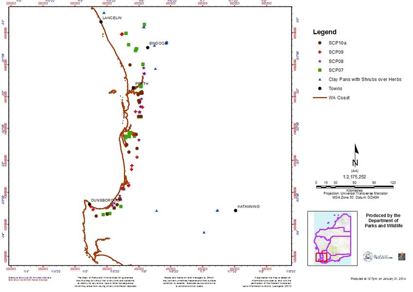
Foreword
This document constitutes the national recovery plan for the Clay pans of the Swan Coastal Plain ecological
community and, as such, considers the requirements of the entity across its known range. It identifies the actions
to be taken to ensure the long-term viability of the entity in nature, and the parties who will undertake these
actions.

This plan has been adopted from Interim Recovery Plan 2015-2020 for Clay pans of the Swan Coastal Plain (Swan
Coastal Plain community types 7, 8, 9 and 10a) and Clay pans with mid dense shrublands of Melaleuca lateritia
over herbs (Interim Recovery Plan No. 354) prepared by the Western Australian Department of Parks and Wildlife.
Interim Recovery Plans (IRPs) are developed within the framework laid down in Department of Parks and Wildlife
Policy Statements Nos. 44 and 50.

IRPs outline the recovery actions that are required to urgently address those threatening processes most
affecting the ongoing survival of threatened taxa or ecological communities, and begin the recovery process.

The Australian Government Department of the Environment and Energy ensures that threatened ecological
communities are protected through the preparation of Conservation Advices or Recovery Plans. The Western
Australia Department of Parks and Wildlife are committed to ensuring that threatened ecological communities
are conserved through the preparation and implementation of Recovery Plans or Interim Recovery Plans. The
Department of Parks and Wildlife ensures that conservation action commences as soon as possible and always
within one year of endorsement of that rank by the department’s Director of Science and Conservation.

The IRP operated in Western Australia from October 2015 but will remain in force until withdrawn or replaced. It
is intended that, if the ecological communities are still ranked Vulnerable or Endangered after five years, the IRP
will be replaced or updated.

The IRP was approved by the Department of Parks and Wildlife’s Director of Science and Conservation on 14
October 2015. The provision of funds identified in the IRP is dependent on budgetary and other constraints
affecting the department, as well as the need to address other priorities. Information in this IRP was accurate as
at September 2015.

The national plan will remain in force until withdrawn or replaced. It is intended that, if the ecological community
is still listed as threatened nationally after five years, the need for further recovery actions and the need for an
updated recovery plan will be evaluated.

                                                                                                                     2
ACKNOWLEDGEMENTS
The IRP was prepared by Valerie English.
The National Recovery Plan was revised from the IRP by the Department of the Environment and Energy and
Department of Biodiversity, Conservation and Attractions.
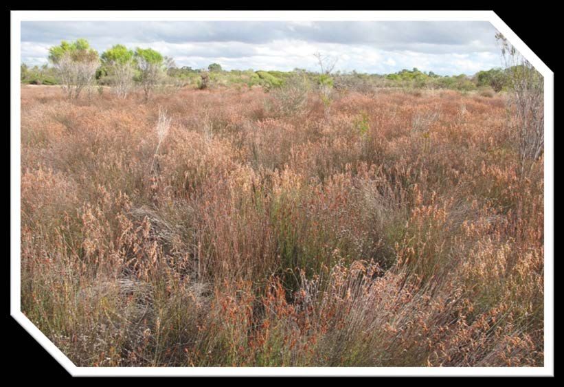
Cover photograph by Valerie English.
The following people provided valuable advice and assistance in the preparation of the Interim Recovery Plan:
Kate Brown Parks and Wildlife, Swan Region
Andrew Webb Parks and Wildlife, South West Region
Anne Harris Parks and Wildlife, Swan Coastal District
Ben Lullfitz Parks and Wildlife, Busselton District
Marie Edgley Parks and Wildlife, Wheatbelt Region
Adam Turnbull Parks and Wildlife, Species and Communities Branch
Cathy Bourke Parks and Wildlife, Perth Hills District
Ken Atkins Parks and Wildlife, Kensington
Jason Wiktotwicz Curtin University student
Brett Beecham Parks and Wildlife, Wheatbelt Region
Bob Huston Parks and Wildlife, Perth Hills District
Deanna Rasmussen Parks and Wildlife, Moora District
CITATION
This National Recovery Plan should be cited as:
Department of Biodiversity, Conservation and Attractions (2019). National Recovery Plan for the Clay pans of the
Swan Coastal Plain Ecological Community. Department of Biodiversity, Conservation and Attractions, Perth,
Western Australia.
It has been adapted from the Western Australian Interim Recovery Plan (2015) which should be cited as:
Department of Parks and Wildlife (2015). Interim Recovery Plan 2015-2020 for Clay pans of the Swan Coastal
Plain (Swan Coastal Plain community types 7, 8, 9 and 10a) and Clay pans with mid dense shrublands of
Melaleuca lateritia over herbs. Interim Recovery Plan No. 354. Perth.
Disclaimer: The State of Western Australia and its employees do not guarantee that this publication is without flaw
of any kind or is wholly appropriate for your particular purposes and therefore disclaims all liability for any error,
loss or other consequence that may arise from you relying on any information in this publication.
The Commonwealth of Australia has made all reasonable efforts to identify content supplied by third parties.
The views and opinions expressed in this publication are those of the original authors and do not necessarily
reflect those of the Australian Government or the Minister for the Environment.
While reasonable efforts have been made to ensure that the contents of this publication are factually correct, the
Commonwealth does not accept responsibility for the accuracy or completeness of the contents, and shall not be
liable for any loss or damage that may be occasioned directly or indirectly through the use of, or reliance on, the
contents of this publication.
© State of Western Australia Government, Department of Biodiversity, Conservation and Attractions 2019
3SUMMARY
Name: This plan encompasses the ‘Clay pans of the Swan Coastal Plain ecological community’ that is listed as
critically endangered under the Commonwealth Environment Protection and Biodiversity Conservation Act 1999
(EPBC Act). This nationally listed ecological community is synonymous with the following four Western Australia
listed threatened ecological communities (TECs) and one priority ecological community (PEC):
• Herb rich saline shrublands in clay pans (Swan Coastal Plain community type 7 as identified in Gibson et
al. 1994 (SCP07))
• Herb rich shrublands in clay pans (SCP08 – Swan Coastal Plain community type 8)
• Dense shrublands on clay flats (SCP09 – Swan Coastal Plain Community type 9)
• Shrublands on dry clay flats (SCP10a – Swan Coastal Plain Community type 10a); and
• the PEC ‘Clay pans with mid dense shrublands of Melaleuca lateritia over herbs’ (hereafter termed the ‘Clay
pans with shrubs over herbs’) that is ranked Priority 1 in Western Australia.
There are 114 occurrences of the clay pan community that covers a total of about 909 ha.
Description: The clay pan communities occur where clay substrate is low in the landscape and forms an
impermeable layer close to the surface. These wetlands that rely on rainfall and local surface drainage to fill are
considered unlikely to be connected to groundwater. The clay pans then dry out to form a relatively impervious
substrate in summer. A suite of perennial plants that propagate by underground bulbs, tubers or corms
(geophytes), and annual herbs flower sequentially as the clay pans dry out. The clay pans are the most diverse of
the Swan Coastal Plain wetlands and contain a number of local endemic flora.
Department of Parks and Wildlife Regions: Swan, South West, Midwest and Wheatbelt
Department of Parks and Wildlife Districts: Swan Coastal, Perth Hills, Wellington, Blackwood, and Moora
Districts.
Local Government Authorities: Serpentine–Jarrahdale, Harvey, Murray, Armadale, Gosnells, Swan, Waroona,
Gingin, Beverley, Bunbury, Busselton, Capel, Dardanup, Kalamunda, Boyup Brook, Toodyay and Kojonup.
Conservation status: Community types 7, 8 and 9 were endorsed by the WA Minister for Environment in
November 2001 as Vulnerable, and community type 10a as Endangered. Clay pans with mid dense shrublands of
Melaleuca lateritia over herbs was ranked Priority 1 in Western Australia in May 2006. The umbrella type ‘Clay pans
of the Swan Coastal Plain’ was listed as Endangered under the EPBC Act in March 2012.
Habitat requirements: These communities typically occur on clay soils in low lying flats that are seasonally wet or
inundated.
Habitat critical to survival: The critical habitat for this community is the clay soils on which the community occurs,
and the fresh surface water that helps to sustain key species in this community, and the catchment for this surface
water.
The habitat critical to survival is: The area of occupancy of known occurrences; similar habitat adjacent to important
occurrences (i.e. within approximately 200m), i.e. poorly drained flats, depressions or winter wet clay flats; remnant
vegetation that surrounds or links several occurrences (this is to provide habitat for pollinators or to allow them
to move between occurrences); and the local catchment for the surface and potentially groundwater that maintains
4the winter-wet habitat of the communities (these clay pan communities would be dependent on maintenance of
the local hydrological conditions).
Important occurrences: Occurrences that provide for representation of the community across its geographic
range and that can be managed for conservation and/or with conservation included in their purpose are
considered important occurrences of this community. Occurrences within conservation reserves and Bush
Forever sites, and occurrences with comparatively large intact areas of the community that are in relatively good
condition outside of Bush Forever, are considered important occurrences.
Affected interests: Land owners and managers of all occurrences may be affected by actions in this plan, in
particular on those lands not managed by Parks and Wildlife or intended to be transferred to the department’s
management. Occurrences are within the Shires of Armadale, Busselton, Boyup Brook, Capel, Gosnells, Murray,
Serpentine-Jarrahdale, Swan, Waroona, Gingin, Bunbury, Capel, Dardanup, Kalamunda, Toodyay and Kojonup.
They occur on land managed by Main Roads WA, Parks and Wildlife, Water Corporation, University of WA, WA
Planning Commission, local governments, and on private land.
Indigenous interests: An Aboriginal Sites Register is kept by the Department of Indigenous Affairs, and lists one
Artifact/Scatter site and a Ceremonial and Morphological site within the vicinity of the occurrences. The South
West Aboriginal Land and Sea Council (SWALSC), an umbrella group, covers the areas considered in this plan.
Appendix 1 identifies areas of the ecological community that contain sites that are known to have particular
aboriginal significance. Actions identify the intention to continue liaison with relevant groups, including
indigenous groups.
Social and economic impacts and benefits: The implementation of this recovery plan has the potential to have
some social and economic impact, where occurrences are located on lands not specifically managed for
conservation, such as road reserves and private property. Recovery actions refer to continued liaison between
stakeholders with regard to these areas. Negotiations will continue with land managers with respect to the future
management of occurrences not in conservation estate.
Related biodiversity impacts and benefits: Thirteen other TECs co-occur within remnant vegetation that
contains the clay pan communities, and will benefit from their management.
Twelve declared rare flora (DRF) are known from the clay pan communities: Calytrix breviseta subsp. breviseta,
Verticordia plumosa var. vassensis, Verticordia densiflora var. pedunculata, Chamelaucium sp. S Coastal Plain
(previously Chamelaucium roycei ms), Diuris purdiei, Grevillea curviloba subsp. incurva, Lepidosperma rostratum,
Ptilotus pyramidatus, Synaphea stenoloba, Trithuria occidentalis, Eleocharis keigheryi and Synaphea sp. Fairbridge
Farm; and 42 priority flora taxa also occur in the communities. Recovery actions implemented to improve the
quality or security of the community are also likely to improve the status of component species.
There are three critically endangered fauna known to be dependent on clay pans and the surrounding communities
for a portion of their life/breeding cycle. These are Pseudemydura umbrina (Western Swamp Tortoise) and two
native bees: Leioproctus douglasiellus and Neopasiphae simplicior.
Term of plan: The plan will remain in force until withdrawn or replaced. It is intended that, if the ecological
community is still listed as threatened nationally after five years, the need for further recovery actions and the need
for an updated recovery plan will be evaluated. The outcomes of the plan will be evaluated by the Midwest, Swan,
Wheatbelt and South West region threatened flora and communities recovery teams.
5IRP Objective(s): To maintain or improve the overall condition of the clay pan communities and reduce the level
of threat.
Criteria for success:
• 90% or more of the aerial extent of occurrences of each clay pan type covered by this recovery plan
maintained at the same condition rank, or improved (Bush Forever condition scales) over the life of the
plan, excluding effects of drying climate that are outside the scope of this plan.
• An increase in the number of occurrences of the clay pan types managed for conservation and/or with
conservation included in the purpose.
• Representative areas of the clay pan types across their geographical range maintained in the same or
improved condition (Bush Forever condition scales).
Criteria for failure:
• Decline in condition rank to a lower category (Bush Forever condition scales) of 10% or more of the total
aerial extent of the sub-communities covered by this plan, excluding effects of drying climate that are
outside the scope of this plan.
• Failure to achieve an increase in the area managed for conservation for the communities covered by this
plan.
Summary of Recovery Actions:
Liaise with stakeholders to implement recovery Identify potential new occurrences
Monitor extent and boundaries of occurrences Map habitat critical to survival
Encompass monitoring in an adaptive management Seek to minimise direct clearing and hydrological
framework change
Develop and implement fire management strategy Implement disease hygiene procedures
Implement weed control Seek long term protection for conservation
Investigate, monitor and manage water quality and Ensure best practice land management in areas of
hydrology competing interests
Implement and monitor control of feral and grazing Develop management guidelines
animals
Protect clay pans from physical damage Report on recovery plan implementation
61. BACKGROUND
1.1 History, defining characteristics and conservation significance
The clay pan basins and clay flats of south western Australia are collectively termed clay pans, and occur where
clay soils form an impermeable layer close to the surface. Wetlands in clay pans rely on rainfall and surface runoff
to fill and are probably not connected to groundwater. These wetlands contain a rich suite of geophytes and annual
species that flower at different times as the clay pans dry towards summer. The clay pans are the most diverse of
the Swan Coastal Plain wetlands and contain high numbers of local endemics. There are no specific suites of flora
that characterise all the clay pans, but they share general characteristics of substrate, landform, hydrology and
vegetation structure. They also all meet Keeley and Zedler’s (1998) definition of vernal pools; ‘precipitation-filled
seasonal wetlands inundated during periods when temperature is sufficient for plant growth, followed by a brief
waterlogged-terrestrial stage and culminating in extreme desiccating soil conditions of extended duration.’
The clay pans are comprised of reasonably productive agricultural soils and many were cleared and drained soon
after European settlement. Other areas were mined for clay for brick and tile manufacture. Remnant vegetation in
clay pans was largely on the Swan Coastal Plain close to metropolitan Perth including in some areas that have
been cleared more recently for urban development.
Gibson et al. (1994) defined a series of floristic community types across the southern Swan Coastal Plain based on
analysis of 509 quadrats. This included four units that occurred on clay substrates, and that varied in floristic
composition due to a suite of factors including substrate and rainfall. These are:
• Herb rich saline shrublands in clay pans (Swan Coastal Plain community type 7 as identified in Gibson et
al. 1994 (SCP07))
• Herb rich shrublands in clay pans (SCP08 – Swan Coastal Plain community type 8)
• Dense shrublands on clay flats (SCP09 – Swan Coastal Plain Community type 9)
• Shrublands on dry clay flats (SCP10a – Swan Coastal Plain Community type 10a)
All of these clay pan types were listed as threatened ecological communities (TECs) in Western Australia in the
1990s.
Data for the vegetation of the seasonal clay-based wetlands across the extent of south western Australia were
analysed by Gibson et al. (2005) and vegetation units were identified based on floristic patterning. An additional
clay pan type named ‘Clay pans with mid dense shrublands of Melaleuca lateritia over herbs’ was identified through
the analysis, and was included on the Priority ecological community list for Western Australia in 2006. In 2012 the
four clay pan types identified by Gibson et al. (1994) and the ‘Clay pans with mid dense shrublands of Melaleuca
lateritia over herbs’ were listed as a critically endangered community under the EPBC Act, under the umbrella title
‘Clay pans of the Swan Coastal Plain ecological community’. This nationally listed ecological community is
synonymous with (and has an identical footprint) to the five state listed clay pan communities.
There are 114 occurrences of the clay pan communities in 50 separate locations that occupy a total of about 909
ha. The communities are highly fragmented, with about 60% of occurrences under 10 ha in size. The clay pan
communities occur in significant bushland including Ellenbrook, Forrestdale Lake, Moore River, Byrd Swamp, Austin
Bay, Drummond and Kooljerrenup Nature Reserves; Wandoo National Park, the Greater Brixton Street Wetlands,
Anstey-Keane damplands, Jandakot Regional Park, and Brickwood Reserve (See Appendix 1, 3).
7A summary of total areas in land management categories for the clay pan types occurs in Table 1.
Table 1: Land management categories for clay pan communities
Community Conservation Other state, local C’mwealth Private Bush Total (ha)
reserves (ha) government lands (ha) lands (ha) Forever
reserves (e.g. (ha)
road, rail,
recreation etc.)
(ha)
SCP 07 124.6 70 7.1 14.4 35.9 216.1
SCP08 116.6 168.5 0.1 12.9 127.3 298.1
SCP09 195.4 23.1 0 0 3.4 218.5
SCP10a 24.8 62.9 0 5 35.4 92.7
Clay pans with 82.9 1.2 0 0 0 84.1
shrubs over
herbs
Total (ha) 544.3 325.7 7.2 32.3 202 909.5
Areas of the clay pans are listed as Wetlands of National Significance, including Brixton Street Wetlands, Ellen
Brook swamp systems, and Forrestdale Lake Nature Reserve which is also a Ramsar site (Environment Australia,
2001). The threatened and priority flora that occur in the clay pan communities are listed in Table 2. Some of the
clay pan sites were identified through surveys completed for Bush Forever, and some also occur in Bush Forever
sites (Keighery et al. 2012; Government of Western Australia 2000; see Appendix 1). The aim of Bush Forever is to
seek to protect listed sites through a specified planning process.
A suite of fauna depend on the vegetation and surface water habitat, and seasonal changes in the clay pans
communities. Three species listed under the EPBC Act are dependent on clay pans and adjacent areas. These are
the critically endangered western swamp tortoise (Pseudemydura umbrina), and two species of native bee;
Leioproctus douglasiellus (endangered) and Neopasiphae simplicior (critically endangered).
Appendix 1 provides a summary of information about the occurrences including land tenure, extent, soils and
condition.
1.2 Biological and ecological characteristics
Seasonal wetlands occur on the clay flats as the clay impedes water movement horizontally and vertically.
Rainfall therefore collects on the surface and soils become waterlogged. These wetlands tend to dry soon after
the rain stops in the late spring and early summer.
The hydrology is the main driver of the ecological functions of the assemblages that occur in clay pans.
Variations in depth and timing of inundation have a major influence over the suites of flora that occur in a
particular location and this explains some of the variation in the community’s composition across its extent.
Changes in hydrological status will significantly alter the assemblages in the communities. More than 90% of the
clay pan communities have been lost through clearing and drainage of their habitat since European settlement.
Much of the high species richness arises from geophytes and annual flora that flower sequentially as the clay pans
dry. Perennial shrubs and herbs contribute less to total species richness (Gibson et al. 2005). The shrubs in clay
8pans may appear stressed or dead over summer with leaves yellowing, but can recover when water is again added
to the system.
The clay pans contain a rich and variable flora including a series of wetland genera that are widespread such as
Isoetes, Myriophyllum, Cotula and Eryngium and a suite that are characteristic of southern Australia including
Stylidium, Tribonanthes, Drosera and Centrolepis. The clay pans also include a series of terrestrial taxa (Gibson et
al. 2005).
There is a high variability in composition in the clay pan wetlands and this may be related to their naturally highly
fragmented distribution, and a highly randomised recruitment of flora taxa (Gibson et al. 2005).
Gibson et al. (1994) defined four clay pan and clay flat communities based on different species composition, with
a significant increase in species richness with rainfall, and higher species richness in flat clay pans as compared to
clay basins. This probably relates to a shorter period of inundation and longer time when soils are wet but when
there is no surface water present (‘wet terrestrial phase’). Both clay pan types are typically completely dry by mid-
summer (Gibson et al. 2005).
Habitat and Floristics
The clay substrate that occurs in these communities is a fine-grained material that combines one or more clay
minerals with traces of metal oxides and organic matter. Clays are plastic due to their water content and become
hard, brittle and non–plastic when dry. The clays that occur in this community can appear in various colors, from
dull grey to brown.
Clays are distinguished from other fine-grained soils by differences in size and mineralogy. Silts, which are fine-
grained soils that do not include clay minerals, tend to have larger particle sizes than clays. There is some overlap
between clays and silts in particle size and other physical properties, and many naturally occurring deposits include
both silts and clay. The proportion of silt and clay will influence the properties of the substrate, and both light clays
with a higher proportion of silt, and heavy clay substrates with low levels of silt can occur in the clay pan
communities. The composition, properties and consistency of the substrate can also vary within any one occurrence
of the community.
The five clay pan communities that are considered in this plan are described below (see Appendix 2 for lists and
characteristics of common taxa):
Herb rich saline shrublands in clay pans (Community Type 7 (SCP07))
The community occurs on heavy clay soils that are generally wet, and may have surface water present, from winter
to mid-summer. Many locations hold water up to 30cm deep in early spring, and early flowering aquatic species
are common. A succession of species including Centrolepis spp. and Stylidium spp. flower as the clay pans dry over
a period of up to three months.
The community can occur under a shrub layer comprising Melaleuca viminea, M. osullivanii, M. cuticularis or
Casuarina obesa or other shrubs but can also occur as woodlands or herblands. Some areas such as where
Melaleuca cuticularis or Casuarina obesa occur as an overstorey may be saline for part of the year due to
evaporation resulting in increased salinity.
A suite of herbs such as Philydrella pygmaea, Brachyscome bellidioides, Centrolepis aristata, Centrolepis polygyna,
Pogonolepis stricta and Cotula coronopifolia; frequently occur in the community. Species such as Angianthus
9drummondii, Eryngium pinnatifidum subsp. Palustre (G.J. Keighery 13459) and Blennospora drummondii occur in
low frequency and were not recorded in community types 8 to 10 (Gibson et al. 1994).
Two Department of Water (DoW) bores occur within about 50m of this clay pan community and groundwater
level data are available over extended periods (Yoongarillup and Bambun reserves (Occurrences 1, 5 – see
Appendix 1) (DoW 2014)). For Bambun reserve, the groundwater has varied seasonally from 4-2.5m below
ground surface since 2012. The Yongarillup bore level varied from two metres below ground to the ground
surface between 2008 and 2013. The soils in the latter occurrence have a higher proportion of sand and a lower
clay component than most other locations. This may result in greater interaction of groundwater and surface
water at this location.
Herb rich shrublands in clay pans (Community Type 8 (SCP08))
The surface pools in this community do not generally contain water to the same depth or for as long as in
community type 7, but aquatic annuals are still common. In the most recent analysis of a more comprehensive
dataset of clay pan data by Gibson et al. (2005) that included areas outside of the Swan Coastal Plain, however,
sites in these deeper basin clay pans grouped separately into the community ‘Clay pans with shrubs over herbs’,
described below. This includes clay pans in the Brixton St wetlands (occurrences 35, 53), Bandicoot Brook
(occurrence 37), Pursers (occurrences 102, 103, 106, 107), Julimar (occurrence 101), and Drummond (occurrences
99, 100).
Viminaria juncea, Melaleuca viminea, M. lateritia or M. osullivanii and occasionally Eucalyptus wandoo generally
dominate this community. Hypocalymma angustifolium, Acacia lasiocarpa var. bracteolata (long peduncle form P1)
and Verticordia huegelii can also occur. Typical herbs include Centrolepis aristata, Chorizandra enodis, Drosera
menziesii subsp. menziesii, Drosera rosulata and Hyalosperma cotula. This community included a relatively high
proportion of weeds due to historical disturbance (Gibson et al. 1994).
A DoW bore occurs in Hay Park in Bunbury bushland in this clay pan type (occurrence 48 – see Appendix 1), and
is screened in the superficial aquifer. Water levels at this location varied seasonally in a range from 1.7 and 5.8m
below ground between 2009 and 2014 (DoW 2014). A private bore occurs in this community in Kenwick, and had
a static water level of 3.5m below ground when drilled in November 2011.
Dense shrublands on clay flats (Community Type 9 (SCP09))
The shrublands or open woodlands of this community are inundated for longer periods and have lower species
richness and numbers of weed taxa than the other clay pan types. Sedges including Chorizandra enodis,
Cyathochaeta avenacea, Lepidosperma longitudinale and Leptocarpus coangustatus (formerly Meeboldina
coangustata) are more common in this community. Shrubs including Hakea varia, Melaleuca viminea and Eutaxia
virgata are common.
There are no high quality bore data available for locations near this clay pan type. Only one bore had publicly
available data, near Wellard Nature Reserve (occurrence 69 – see Appendix 1). The readings were taken during
winter 1962 and summer 1974, with the level varying from about 1.9m to 2.1m below the surface.
Shrublands on dry clay flats (Community Type 10a (SCP10a))
The community occurs on skeletal soils that have shallow microtopography and the habitat is the most rapidly
drying of the four clay pans identified in Gibson et al. (1994). Shrubs in the community include Hakea sulcata,
10Hakea varia, Pericalymma ellipticum and Verticordia densiflora. Herbs and sedges that are also common include
Schoenus rigens, Aphelia cyperoides, Centrolepis aristata, Schoenolaena juncea, Drosera gigantea subsp. gigantea,
and Drosera menziesii subsp. menziesii.
There are three bores which occur within 20m of the community. These are railway reserves Capel (BY25B, BY25A
occurrence 95) and a private bore in Capel (occurrence 87). The range of the static water level is between 2.01m
to 9.35m from top of casing with the recording taken at the end of autumn (27/05/2009); with one recording
showing levels dropping to 1.22 m from ground level but with no date provided.
Clay pans with shrubs over herbs (See also Appendix 3 for list of common taxa)
These clay pans are usually dominated by a shrubland of Melaleuca lateritia (robin red breast bush) with dense
herbs. This community is known from the Swan Coastal Plain and Jarrah Forest IBRA regions.
The clay pans are characterised by taxa that are adapted to presence of surface water such as Hydrocotyle
lemnoides or to a combination of terrestrial and wet phases such as Glossostigma diandrum, Liparophyllum
capitatum (formerly Villarsia capitate), and Eleocharis keigheryi (Gibson et al. 2005).
Forbes and Vogwill (2012) studied water relations in a clay pan of this type in Drummond Nature Reserve. They
found evidence that there is little connection between the surface and groundwater systems. There is one private
bore within or in the 20m buffer zone of the community (SWAMP 117).
Hydrology
There are few data available on surface water characteristics of the clay pan communities, however V & C
Semeniuk Research Group (2001) completed detailed hydrological studies of the Brixton Street wetlands in
Kenwick that are dominated by clay pans (including occurrences 35, 53-56, 92). They noted that discharge of
ponded water can occur through slow infiltration or evapo-transpiration, with slow rainfall runoff from former
natural channels and constructed tracks occurring at 0.002-0.006 m3/second for several days to weeks after rain.
Sumplands (primarily clay pans) are inundated at the Brixton Street site for three to five months a year and reach
a maximum depth of 40-50cm, with tracks holding water for longer periods (V & C Semeniuk Research Group
2001).
V & C Semeniuk Research Group (2001) note that groundwater in the muds (clays) and muddy sands was
hyposaline and increased with depth. Water in adjacent drains that were probably mainly collecting surface water
was fresh. Moisture contents were highest during maximum rainfall with wetlands that contained muds (clays)
retaining moisture for longest in the Brixton St wetlands (V & C Semeniuk Research Group 2001). The amount of
moisture in the top 15cm of soil was low across the site, but greatest in muds (clays), then muddy sands, then
sands. The sands therefore had the lowest moisture retention rate and highest porosity. Differences in soil
moisture retention have implications for drought tolerance of the associated vegetation, with greater impacts of
drought occurring in vegetation on sandy clay soils than on clays due to high porosity and lower moisture
retention. Lower rainfall periods can cause reduced flowering seasons and stunted growth, decreased
recruitment of less drought tolerant taxa such as some annuals and increases in more drought tolerant flora, and
death of more drought susceptible taxa (V & C Semeniuk Research Group 2001).
The hydrographs for a drain adjacent to the Brixton St wetlands during below average rainfall were below
groundwater level, so this drain primarily affects surface water (V & C Semeniuk Research Group 2001). In
periods of below average rainfall, regional groundwater therefore has minor influence on the Brixton St wetlands
11with the major influences being direct rainfall, ponding, infiltration and sub-surface perching. In wetter periods,
groundwater levels may reach the drains. The effect of drains is, however, to shorten periods of inundation and
waterlogging of surface sediments and the potential for infiltration.
Studies of linkages between groundwater and surface water in the south west Australian clay pans are very
limited, but where completed generally indicate a lack of connection between the two systems. For example
Forbes and Vogwill (2012) studied two clay pans in Drummond Nature Reserve, including an occurrence of the
Clay pans with shrubs over herbs. They found evidence that there is little connection between the surface and
groundwater systems. V & C Semeniuk Research Group (2001) also concluded that there is no relationship
between groundwater and wetlands at some of the Greater Brixton Street sites, that includes several clay pan
types.
In addition there are data for a few bores that occur close to or within the clay pan communities, and the bore
data for these have been extracted from Department of Water (2014) Water INformation (WIN) database. The
figures below provide data about changes in groundwater depth over time beneath examples of the clay pan
communities. In each case, zero metres represents ground surface. The figures indicate the seasonal nature of
the superficial watertable, and the lack of connection of groundwater to surface in each case.
Figure 1: Bore data from 2003 to 2014 for occurrences 99, 100 of clay pans with shrubs over herbs in Drummond
Nature Reserve. Water depth below ground, adapted from Forbes and Vogwill 2011 and Department of Parks and
Wildlife unpublished data. The base of the bore is at 5.4m, and the bore is dry when level is -5.4m.
Time
0
-1
-2
-3 Water level depth (m)
-4
-5
-6
Figure 2: Bore data 2012-2013 for a clay pan type SCP07 in Bambun reserve (depth below ground, occurrence 5;
data from DoW 2014)
12Time
0
0 200 400 600 800 1000 1200 1400 1600 1800
-1
Depth (m)
-2
-3
-4
-5
Figure 3: Bore data for Hay Park SCP08 clay pan for 2009-2014 (depth below ground; occurrence 48; data from
DoW 2014)
Time
0
0 1000 2000 3000 4000 5000 6000
-1
-2
-3
-4
-5
-6
-7
Figure 4: Bore data for 2009-2013 for Yoongarillup clay pan community type SCP07 (occurrence 1; WIN site
reference 23023199, depth below ground; data from DoW 2014)
Time
1
0
-1
Water Level
-2
-3
-4
Indirect evidence suggests that evaporation of surface waters can result in increases in salinity in clay pan
substrates. For example, samphires and Casuarina obesa, that are adapted to saline soils, are recorded from a
13suite of locations, in particular, of the Herb rich saline shrublands in clay pans. Locations that have samphires in
the clay pans include Bullsbrook Nature Reserve (occurrence 8) and Brixton St wetlands (occurrences 35, 53).
Related biodiversity impacts and benefits
Other TECs, declared rare and priority flora, and threatened fauna, either occur in the remnant vegetation
containing the clay pan communities or within the communities themselves, and will benefit from recovery
actions implemented to improve the quality or security of the community.
Other TECs co-occurring within remnant vegetation that contains the clay pan communities are:
• Southern wet shrublands, Swan Coastal Plain (community type 2 endangered)
• Shrublands on southern Swan Coastal Plain Ironstones (Busselton area) (community type 10b, critically
endangered)
• Corymbia calophylla woodlands on heavy soils of the southern Swan Coastal Plain (community type 1b,
vulnerable)
• Corymbia calophylla - Kingia australis woodlands on heavy soils, Swan Coastal Plain (community type 3a
critically endangered)
• Corymbia calophylla – Xanthorrhoea preissii woodlands and shrublands (community type 3c, critically
endangered)
• Corymbia calophylla - Eucalyptus marginata woodlands on sandy clay soils of the southern Swan Coastal
Plain (community type 3b vulnerable)
• Forests and woodlands of deep seasonal wetlands of the Swan Coastal Plain (Plain (community type 15
vulnerable)
• Shrublands on calcareous silts of the Swan Coastal Plain (community type 18 vulnerable)
• Banksia attenuata woodlands over species rich dense shrublands (community type 20a, endangered)
• Eastern Banksia attenuata and/or Eucalyptus marginata woodlands (community type 20b, endangered)
• Shrublands and woodlands on Muchea Limestone (endangered)
• Whicher Scarp Paluslope wetlands (priority 1)
• Wandoo woodland over dense low sedges of Mesomelaena preissii on clay flats (priority 2)
A list of the 12 declared rare flora and 42 priority taxa that occur with the clay pan communities is presented in
Table 2.
Table 2: Threatened and priority flora that occur in the clay pan TEC
Species name Conservation status (WA) Conservation status
(EPBC Act 1999)
Acacia flagelliformis P4
Acacia inops P3
Amperea micrantha P2
Angianthus drummondii P3
Aponogeton hexatepalus P4
Banksia meisneri subsp. P4
ascendens
Blennospora doliiformis P3
Boronia anceps P3
14Boronia tetragona P3
Calytrix breviseta subsp. DRF (CR) EN
breviseta
Centrolepis caespitosa P4 EN
Chamaescilla gibsonii P3
Chamelaucium sp. S coastal DRF (VU) VU
plain (R.D.Royce 4872)
Chordifex gracilior P3
Diuris purdiei DRF (EN) EN
Eleocharis keigheryi DRF (VU) VU
Eryngium pinnatifidum subsp. P3
Palustre
Eryngium sp. Ferox P3
Eryngium sp. Subdecumbens P3
(G.J. Keighery 5390)
Gastrolobium sp. Yoongarillup P1
Grevillea brachystylis subsp. P3
brachystylis
Grevillea curviloba subsp. DRF (EN) EN
incurva
Grevillea thelemanniana P2
subsp. thelemanniana
Hakea oldfieldii P3
Hydrocotyle lemnoides P4
Hemigenia microphylla P3
Isotropis cuneifolia subsp. P2
glabra
Isopogon formosus subsp. P3
dasylepis
Laxmannia jamesii P4
Lepidosperma rostratum DRF (EN) EN
Lepyrodia heleocharoides P3
Loxocarya magna P3
Montia australasica P2
Meionectes tenuifolia (formerly P3
Haloragis tenuifolia)
Myriophyllum echinatum P3
Ornduffia submersa P4
Schoenus benthamii P3
Schoenus capillifolius P3
Schoenus natans P4
Schoenus sp. Waroona P3
Ptilotus pyramidatus DRF (CR) CR
15Stylidium longitubum P3
Stylidium roseonanum P3
Synaphea hians P3
Synaphea sp. Fairbridge Farm DRF (CR) CR
Synaphea petiolaris subsp. P2
simplex
Synaphea stenoloba DRF (CR) EN
Tribulus minutus P1
Trichocline spathulata P2
(formerly T. sp. Treeton)
Trithuria occidentalis DRF (CR) EN
Verticordia densiflora var. DRF (EN) EN
pedunculata
Verticordia lehmannii P4
Verticordia lindleyi subsp. P4
lindleyi
Verticordia plumosa var. DRF (EN) EN
vassensis
There are three critically endangered fauna known to be dependent on clay pans and the surrounding communities
for a portion of their life/breeding cycle. These are Pseudemydura umbrina (Western Swamp Tortoise) and two
native bees: Leioproctus douglasiellus and Neopasiphae simplicior.
Leioproctus muelleri is a recently discovered native bee that is only known from Keane Rd (Occurrences 88 and 89)
but is not listed as threatened fauna.
Habitat critical to survival, and important occurrences
Habitat critical to survival includes the area of occupancy of known occurrences; similar habitat adjacent to
important occurrences (i.e. within approximately 200m), i.e. poorly drained flats, depressions or winter wet flats
with shallow sands and loams; remnant vegetation that surrounds or links several occurrences (this is to provide
habitat for pollinators or to allow them to move between occurrences); and the local catchment for the surface,
and potentially groundwater, that maintains the winter-wet habitat of the community. The plant assemblages are
dependent on maintenance of the local hydrological conditions.
Occurrences that provide for representation of one of the clay pan communities across its geographic range and
that can be managed for conservation and/or with conservation included in their purpose are considered critical
to the survival of the clay pan communities and are therefore important occurrences. Occurrences within
conservation reserves and Bush Forever sites (eg Brixton St wetlands occurrences 4, 35, 53-56; Forrestdale Nature
Reserve occurrences 34, 51; Moore River Nature Reserve occurrence 22; Byrd Swamp occurrence 70; Drummond
Nature Reserve occurrences 99, 100; Lake Wannamal Nature Reserve occurrences 102, 103, 106, 107; Wandoo
National Park occurrence 111, Fish Road Nature Reserve occurrences 2, 76, and Tuart Forest eastern wetlands
occurrences 113, 114); and occurrences with comparatively large intact areas of the community that are in relatively
good condition outside of Bush Forever, are considered important occurrences (eg Austin Cove occurrences 26-
29; Vasse-Yallingup rail reserve occurrence 74; Waroona occurrence 81).
161.5 International Obligations
This plan is fully consistent with the aims and recommendations of the Convention on Biological Diversity, ratified
by Australia in June 1993, and will assist in implementing Australia’s responsibilities under that convention. This
community is not listed under any specific international treaty, however, and therefore this IRP does not affect
Australia’s obligations under any other international agreements.
1.6 Indigenous interests
An Aboriginal Sites Register is kept by the Department of Aboriginal Affairs, and lists Artifact/Scatter and
Ceremonial and Morphological sites in the vicinity of occurrences. The South West Aboriginal Land and Sea
Council (SWALSC), an umbrella group, covers the areas considered in this plan. Appendix 1 identifies areas of the
ecological community that contain sites that are known to have particular aboriginal significance. Actions identify
the intention to continue liaison with relevant groups, including indigenous groups.
1.7 Social and economic impacts and benefits
The implementation of this recovery plan has the potential to have some social and economic impact, where
occurrences are located on lands not specifically managed for conservation, such as road reserves and private
property. Recovery actions refer to continued liaison between stakeholders with regard to these areas.
Negotiations will continue with land managers with respect to the future management of occurrences not in
conservation estate.
Where specific active recreational pursuits such as four wheel driving and motorbike riding are prevented
through access control, this may be perceived as a social impact, however, such access control also helps to
prevent the continued degradation of the community and maintain other social benefits.
Occurrences may be threatened by proposals to clear for various developments or from hydrological change
following clearing and development of adjacent land. Implementation of actions such as seeking to protect the
hydrological processes in the areas adjacent to the community may result in a perceived impact on
development.
1.8 Affected interests
Occurrences occur within the Shires of Armadale, Busselton, Carpel, Gosnells, Murray, Serpentine- Jarrahdale,
Waroona, Gingin, Bunbury, Beverley, Capel, Dardanup, Kalamunda, Toodyay and Kojonup. They occur on land
managed by local governments, administrators of railways, Public Transport Authority of Western Australia,
Western Australian Planning Commission/ Department of Regional Development and Lands, Main Roads WA,
Parks and Wildlife, Perth Airports Corporation, Conservation Commission, Water Corporation, University of WA,
WA Planning Commission, and on private property.
1.9 Term of plan
The plan will remain in force until withdrawn or replaced. It is intended that, if the ecological community is still
listed as threatened nationally after five years, the need for further recovery actions and the need for an updated
recovery plan will be evaluated. The outcomes of the plan will be evaluated by the Midwest, Swan, Wheatbelt and
South West region threatened flora and communities recovery teams.
171.10 Strategies for recovery
To identify, and influence the management of the areas in which the community occurs, so maintaining natural
biological and non-biological attributes of the sites and the current area covered by the community.
To conduct appropriate research into the ecological characteristics of the community to develop further
understanding about the management actions required to maintain or improve its condition.
2. THREATENING PROCESSES
Clearing
The seasonal clay-based wetland communities of the south west are amongst the most threatened assemblages
in Western Australia. It is estimated that >90% of the original extent of these wetlands has been cleared for
agricultural use (Gibson et al. 2005). Clay pans in the Perth area have also historically been cleared and quarried
for clay for use in manufacturing bricks and tiles.
Hydrological changes
Altered hydrology due to anthropogenic causes, in urbanised areas in particular, is likely to be an increasing
threat to the clay pans. Drainage to lower watertables, clearing resulting in a decline in evapotranspiration and
increased surface runoff, and water quality declines are likely to increasingly impact the hydrologic regimes of
the clay pan communities. Altered periods of ponding may affect the timing of growth of herbs in the
understorey, and may also affect the species composition of the community by favoring different taxa. Any
changes to the natural hydrology of the clay pans can affect composition as they are dependent on the timing of
filling and drying at appropriate times of the year.
Increased nutrient levels in surface water in occurrences adjacent to areas such as farm lands and residential
areas is likely to favour weeds as weeds are adapted to higher nutrient levels than native flora.
Hydrological changes such as increased depth or period of inundation may cause salt accumulation near the
surface. This has been noted in areas of the southern Swan Coastal Plain since around the 1950s as a result of
clearing (Smith and Ladd 1994). Due to the widespread clearance of native perennial vegetation and its
replacement with urban areas and farmlands, rising groundwater in the surrounding region may result in
increased surface water into clay-based wetlands (Gibson et al. 2005). Salinity risk mapping indicates that many
clay pans are in susceptible areas (National Land and Water Resources Audit 2001).
Salinisation may increase as a result of evaporation of surface water. If increased ponding occurs in the
community due to urbanisation or clearing in the catchment, evaporation of a greater volume of water may
result in larger amounts of residual salt. This is especially true for clay soils, which inhibit rainfall infiltration and
result in high evaporation rates and concentration of salts (Davidson 1995).
18Salinisation and increased nutrients have been observed at a clay pan in Drummond Nature Reserve (Chow et al.,
2010). There is currently no hydrological connection between the surface water in the clay pan and groundwater
at this site, however evidence suggests increased volumes of nutrient enriched water in the clay pan as a result of
regional clearing.
In some other areas groundwater is very close to the surface. At clay pans in Brixton Street, groundwater is 0–3
metres below the surface at the end of spring (Davidson, 1995). Surface waters may link to groundwater in winter
and may influence the quantity and quality of water on the surface of the sites.
The levels of salinity in the community will need to be monitored to determine if salinisation poses a major
threat to the communities, and the sources determined.
Weed invasion
Weeds change the natural diversity and balance of ecological communities and are a major threat to the clay
pans. About 16% of the flora for the clay pans are weeds (Gibson et al., 2005) and some are particularly
aggressive.
Weeds displace native plants, particularly following disturbances such as too frequent fire, grazing or partial
clearing, and compete with them for light, nutrients and water. They can also prevent recruitment, cause changes
to soil nutrients, and affect abundance of native fauna. They can also impact on other conservation values by
harbouring pests and diseases, and increasing the fire risk.
Introduced South African bulbous plants are a particularly serious group of weeds in clay pans. As the taxa occur
in similar habitat in South Africa, many have the ability to invade relatively undisturbed clay pan habitat and
displace the rich herbaceous flora. Watsonia meriana, Sparaxis bulbifera (harlequin flower), Moraea flaccida (one
leafed cape tulip), Hesperantha falcata and Freesia alba x leichtlinii (freesia) are of particular concern. Seed and
cormels are spread into undisturbed areas in sheet waterflow across wetlands (Brown and Brooks 2003b, Brown
et. al., 2008). South African perennial grasses are another serious group of weeds that also occur in similar
habitat in South Africa and have the ability to invade clay pans in good condition following disturbance events
such as fire. Tribolium uniolae (haas grass), Eragrostis curvula (lovegrass) and Hyparrhenia hirta (tambookie grass)
are of particular concern and are a priority for control. The impacts of annual weeds are less well known but
many move into intact vegetation following a disturbance event and appear to displace the native annual flora.
These include Isolepis hystrix, Parentucellia viscosa (bartsia) and Hypochaeris glabra (flat weed) (see also
Appendix 2).
Sources of weed invasion include adjoining areas of urban and agricultural use, drains, and tracks within and
near the clay pans. All these sources increase vulnerability to weed invasion following any type of disturbance.
The clay pans appear reasonably resistant to weed invasions due to seasonal inundation and hardness of soils in
the summer and changes to these elements may alter their ability to resist weed invasion (Keighery 1996).
Grazing
Grazing of native vegetation causes alterations to species composition through selective removal of edible
species, the introduction and enhancement of weeds by the addition of dung, and through trampling and
general disturbance. The presence of feral animals such as rabbits (Oryctolagus cuniculus) and pigs (Sus scrofa) is
a concern as they disturb the vegetation by grazing and burrowing.
19Occurrences at Fish Road (Occurrence 2, 76), Forrestdale Lake (Occurrences 33, 34, 46, 47, 80, 86), Nicholson
Road (Occurrences 43, 44, 82), Karnup Road (Occurrence 45), Plantation Road (Occurrence 87), Keane Road
(Occurrences 88 and 89), Brixton St (rabbits, occurrences 35, 50, 53), Ellen Brook (rabbits are fenced in, foxes are
fenced out, occurrence 31), Bullsbrook (occurrence 8), Austin Bay (occurrence 12) have all been threatened by
grazing to some degree, namely by rabbits, horses and kangaroos. The significance of the impact, however, has
not been quantified through monitoring. Pigs have been recorded at Goonaping, and Moore River and
Drummond Nature Reserves (occurrences 22, 111, 99 and 100).
Altered fire regimes
Inappropriate fire regimes are a significant threat to the clay pan communities. Historically, fire within the clay
pans was probably only very occasional. It is likely that some of the clay pan types such as the Shrublands on dry
clay flats may be adapted to occasional fire as they contain species that will easily carry fire when vegetation is
dry, and some component shrubs would reproduce from seed following fire. The fire response of the major types
of clay pan vegetation needs to be determined however.
The risk of fire is generally increased by the presence of urban areas nearby. In addition, grassy weeds in the
understorey are often more flammable than many of the original native species in the herb layer. Many of the
occurrences have been burnt recently, including the occurrences on Fish Road (Occurrence 2, 76) and Nicholson
Road (Occurrences 43, 44, 82). The fire responses of the typical and common vascular plants in the clay pan types
(from Gibson et al. 1994) occur in Appendices 2 and 3.
Anecdotal evidence indicates that fire may exacerbate the impact of drying climate in clay pan communities. For
example, following fire in Ambergate reserve (encompasses occurrence 21) community structure altered and
reduced rainfall is believed to be a contributing factor. Shrub species such as Pericalymma ellipticum and
Verticordia plumosa var. ananeotes have not recovered well post-fire and there has been a notable increase in
sedge cover ( 1B. Lullfitz personal communication).
Disease
Soil types have a clear correlation with the occurrence of dieback disease caused by the water moulds
Phytophthora species around the Perth metropolitan area. Davison and Tay (1986) state ‘Increased sporulation
and growth of P. cinnamomi will not occur in waterlogged soil because aeration is inadequate’. The clay pan
communities occur on heavier soils that are thus probably a less susceptible habitat, resulting in a reduced
susceptibility of the communities to the disease, although the disease has been recorded at Bullsbrook Nature
Reserve (contains occurrence 8). In order for the disease to take hold within the occurrences a combination of
factors such as temperature and rainfall need to be optimal for the spread of dieback. Regardless the risk of
disease introduction should be minimized by ensuring good hygiene procedures. This includes adequately
washing down any equipment used on or adjacent to the community and restricting access by vehicles and
machinery to dry soil conditions.
Phytophthora dieback disease particularly affects Proteaceae and Myrtaceae families that are floristically and
structurally dominant in some areas of the clay pan communities.
Plant species growth form may influence susceptibility to Phytophthora dieback disease, with the herbaceous
perennials, annuals and geophytes that are common in these clay pans being apparently unaffected. Woody
1
Ben Lullfitz, Department of Parks and Wildlife, Busselton
20perennials are generally found to be the most susceptible. Monocotyledons generally have low susceptibility to
the disease, as their density increases in sites with historical infections as compared with healthy uninfected
areas. As the clay pan communities generally have a high proportion of their diversity associated with the annual
herb and sedge layers, these particular communities may be less affected than other sites that are dominated by
other structural formations such as woodlands and forests.
The disease Myrtle Rust (Puccinia psidii sens. lat) also has potential to impact the clay pans if it becomes
established in Western Australia, as it may affect some of the dominant myrtaceous shrubs in the community
(Australian Network for Plant Conservation 2012).
Loss of overstorey including taller shrubs caused by either Phytophthora species or Myrtle Rust may lead to a
change in the herb layers as a result of increased sun penetration and decreased shading.
Disturbance from recreational activities
Inappropriate recreational uses such as four wheel drive vehicles and dirt bikes pose a risk to the clay pan
communities. Rubbish dumping also occurs in clay pans that are close to urban areas such as Brixton St
Wetlands. These activities cause direct damage to vegetation, and can lead to weed, or disease introductions
such as Phytophthora species.
Drying climate
The clay pans are at risk from a drying climate with effects such as reduced surface water due to significantly less
rainfall. As winter rainfall declines over the Swan Coastal Plain there may be a significant impact to the clay pans
and component species that are dependent on particular water regimes. The drying trend in the south-west of
Australia is forecast to significantly worsen (Western Australia Climate Science Centre, 2010). It is noted, however,
that a drying climate as a threatening process is outside the scope of this recovery plan.
3. GUIDE FOR DECISION-MAKERS
Any on-ground works (significant clearing, burns, proposals with potential to alter drainage or water quality) within
or in the immediate vicinity of the clay pans should be assessed. Proponents should demonstrate that on-ground
works will not have a significant impact on the clay pan communities, or on their habitat or potential habitat. This
includes avoiding or mitigating:
• land clearing leading to loss of locations defined as ‘core areas’ of the clay pans
• clearing leading to significant increase in fragmentation of the communities
• a significant increase in opportunity for introduction or increase in density of weeds or
introduced /feral animals known to damage the communities
• proposals that will result in a significant increase in fire frequency
• proposals that will modify the hydrological regime of the clay pans.
4. CONSERVATION STATUS
Four components of the community are listed as threatened ecological communities (TECs) endorsed by the WA
Minister for the Environment. They are:
• Herb rich saline shrublands in clay pans (Community Type 7 (SCP07)) – Vulnerable
21• Herb rich shrublands in clay pans (Community Type 8 (SCP08)) – Vulnerable
• Dense shrublands on clay pans (Community Type 9 (SCP09)) – Vulnerable
• Shrublands on dry clay flats (Community Type 10a (SCP10a)) – Endangered.
The fifth component of the community, ‘Clay pans with shrubs over herbs’, is listed as Priority 1 by Department
of Parks and Wildlife.
The umbrella type ‘Clay pans of the Swan Coastal Plain’ ecological community is listed as critically endangered
under the EPBC Act.
Components of the clay pan communities are in Wetlands of National Significance, including Brixton Street
Wetlands, the Ellen Brook Swamps Systems; and Ramsar sites, including Forrestdale Lake Nature Reserve and the
Peel-Yalgorup System (Environment Australia, 2001).
5. RECOVERY OBJECTIVES AND CRITERIA
5.1. Objectives
To conserve the ecological and conservation values of the clay pan communities of the Swan Coastal Plain by:
• Maintaining or improving the overall condition of each of the clay pan communities.
• Reducing the level of threat to each of clay pan communities.
5.2 Criteria for success:
• 90% or more of the aerial extent of occurrences of each clay pan type covered by this recovery plan,
maintained at the same condition rank, or improved (Bush Forever condition scales) over the life of the
plan, excluding effects of drying climate that are outside the scope of this plan.
• An increase in the number of occurrences of the clay pan types managed for conservation and/or with
conservation included in the purpose.
• Representative areas of the clay pan types across their geographical range maintained in the same or
improved condition (Bush Forever condition scales).
5.3 Criteria for failure:
• Decline in condition rank to a lower category (Bush Forever condition scales) of 10% or more of the total
aerial extent of the communities covered by this plan, excluding effects of drying climate that are
outside the scope of this plan.
• Failure to achieve an increase in the area managed for conservation for the communities covered by this
plan.
6. RECOVERY ACTIONS
The responsible authority is frequently listed as the relevant Parks and Wildlife District. This refers largely to
initiating and guiding actions. However, in general the relevant Parks and Wildlife District, in liaison with the Species
and Communities Branch and the relevant Recovery Team share the primary responsibility for securing funds for,
and/or coordinating the implementation of, recovery actions.
22You can also read