Five Rivers Reserve FF - Tasmanian Land Conservancy
←
→
Page content transcription
If your browser does not render page correctly, please read the page content below
FIVE RIVERS RESERVE

               FF
Five Rivers Reserve

                      Five Rivers Reserve - Andy Townshend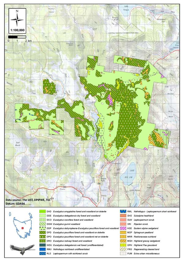
Five Rivers Reserve
Management Plan 2014 - 2019

Tasmanian Land Conservancy (2014). Five Rivers Reserve Management Plan 2014 – 2019. Tasmanian Land
Conservancy, 827 Sandy Bay Road, Tasmania Australia 7005.

Copyright ©Tasmanian Land Conservancy

The views expressed in this report are those of the Tasmanian Land Conservancy and not the Federal or State
Governments, or BHP Billiton. This work is copyright. It may be reproduced for study, research or training purposes
subject to an acknowledgment of the sources and no commercial usage or sale. Requests and enquires concerning
reproduction and rights should be addressed to the Tasmanian Land Conservancy.

Front Image: The Five Rivers Reserve landscape © Andy Townsend

Contact Address

Tasmanian Land Conservancy

PO Box 2112, Lower Sandy Bay,

827 Sandy Bay Road, Sandy Bay TAS 7005

| p: 03 6225 1399 | www.tasland.org.au
CONTENTS
Acknowledgments                                     2
Acronyms and Abbreviations                          3
INTRODUCTION                                        4
The Tasmanian Land Conservancy                      4
The Five Rivers Project                             4
Five Rivers Reserve                                 5
Location and Tenure                                 6
Access                                              6
Bioregional and Landscape Context                   6
RESERVE STATUS                                      9
IUCN Protected Area Management Category             9
Legal Status and Compliance                         9
NATURAL VALUES                                      11
Vegetation Communities                              11
Flora Species of Conservation Significance          11
Fauna Species of Conservation Significance          16
Geo-conservation Values                             20
Invasive Pest Species                               20
Scientific Studies                                  21
CULTURAL VALUES                                     22
Past and Current Management                         22
RESERVE MANAGEMENT FRAMEWORK                        23
Management Plan Vision                              23
Adaptive Management                                 23
Conservation Action Planning                        23
Implementation of Management Strategies             24
Monitoring and Evaluation                           24
Reporting                                           24
MANAGEMENT PLAN OVERVIEW                            25
CONSERVATION TARGETS                                26
Highland Marshes                                    26
Streams and Wetlands                                28
Highland Forest and Woodland                        30
Carnivorous Marsupials                              32
SOCIAL TARGETS                                      34
Community Connection with the Landscape             34
Cultural Heritage Values                            36
Regional Capacity                                   36
MANAGEMENT STRATEGIES                               37
Build Resilience to Climate Change                  37
Access Management                                   38
Fire Management                                     39
Clarence Galaxias Protection                        40
Threatened Species Protection                       41
Carnivorous Marsupial Management                    42
Feral and Domestic Animal Management                43
Weed Management                                     44
Neighbour Relations                                 45
Enhanced Regional Capacity and Ecosystem Services   46
Visitor Management                                  47
Protect Cultural Heritage Sites                     48
Community Engagement                                49
MANAGEMENT PLAN PROCESS                             50
Management Plan Status                              50
Management Responsibilities                         50
Stakeholder Involvement                             50
Management Plan Review                              50
REFERENCES                                          51

Five Rivers Management Plan 2014 - 2019                  Page 1
Acknowledgements

The Five Rivers Reserve is owned by the Tasmanian Land Conservancy and managed as a permanent reserve for its
conservation values. Skullbone Plains, which is part of the Five River Reserve, was purchased through a
combination of generous donations, specifically the philanthropy of Rob and Sandy Purves, Graham Wood, the
Australian Government's National Reserve System and many other individuals and companies. The Bronte
properties were purchased with the generous assistance of Jan Cameron through the Elsie Cameron Foundation.
Since their acquisition, a very significant financial partnership has been established with BHP Billiton and their
global partner Conservation International, to ensure the conservation values of this area are managed and
protected in perpetuity.

The development of a separate Skullbone Plains Reserve Management Plan was administered by a Steering
Committee comprising representatives from the Australian Government, Tasmanian Parks and Wildlife Service and
TLC. The TLC would like to particularly acknowledge the guidance from this steering committee (Nadia Babicka,
Damian Wrigley, Leanne Wilks, Don Thompson and Barry Batchelor). This management plan has been prepared by
TLC staff with input from our project partners Conservation International, and assistance from the Aboriginal Land
Council of Tasmania, Michael Johnston, Forestry Tasmania, Hydro Tasmania, DPIPWE and other scientific experts
and interest groups. This management plan was peer reviewed by the TLCs Conservation Science and Planning
Advisory Council and a final version approved by the TLC Board in 2013.

The TLC would also like to acknowledge the generous support given by a range of stakeholders such as the
Tasmanian Parks and Wildlife Service Lake St Clair District, David Hean, Kathy Van Dullemen, members of the
Bronte Deer Stalkers especially Wayne Turale and the Bronte Park general store owner Shane Hedger.

The TLC acknowledges the data provided by Land Information System Tasmania (theList) and DPIPWE Natural
Values Atlas, and infrastructure, natural, cultural and production data from Gunns Ltd, all of which has been used
to prepare boundary maps and maps of special values.

The TLC greatly appreciates the assistance of its many supporters and volunteers who continue to contribute time
and labour towards management and in particular the Purves Environmental Fund, Purryburry Trust, BHP Billiton
and Conservation International who have supported on-ground research, monitoring and management of this area
since its acquisition.

Five Rivers Management Plan 2014 - 2019                                                                       Page 2
Acronyms and Abbreviations
Bush Blitz    A partnership between the Australian Government, BHP Billiton Sustainable Communities and
              Earthwatch Australia that aims to fill gaps in biological knowledge in Australia’s national reserves.

CI            Conservation International. CI is a nonprofit environmental organization headquartered in the USA
              whose mission is to protect nature and its biodiversity for the benefit of humanity.

DFTD          Tasmanian devil facial tumour disease

DPIPWE        Tasmanian Government’s Department of Primary Industries, Parks, Water and Environment

DSEWPC        Commonwealth Government’s Department of the Sustainability, Environment, Water, Population
              and Community

EA            Environment Australia

EPBC Act      Australian Environment Protection and Biodiversity Conservation Act 1999

Five Rivers   The Five Rivers Reserve comprises Skullbone Plains and the Bronte properties previously known as
              Viormy, Pine Tier Lagoon, Roscarborough and Serpentine. The Five Rivers are the Nive, Serpentine,
              Pine, Little and Little Pine rivers.

FPA           Forest Practices Authority

IBRA          Interim Biogeographic Regionalisation for Australia. A planning framework for the systematic
              development of a comprehensive, adequate and representative ‘CAR’ National Reserve System.

IFS           Inland Fisheries Service, Tasmania

IUCN          International Union for Conservation of Nature

NC Act        Tasmania’s Nature Conservation Act 2002

NRM           Natural Resource Management

NRS           National Reserve System

NVA           Natural Values Atlas database, DPIPWE

PWS           Parks and Wildlife Service, Tasmania

STTDP         Save The Tasmanian Devil Program, DPIPWE

TLC           Tasmanian Land Conservancy

TSP Act       Tasmania’s Threatened Species Protection Act 1995

TSS           Threatened Species and Marine Section, DPIPWE

UNESCO        The United Nations Educational, Scientific and Cultural Organization (WHA nominations and listings)

UTAS          University of Tasmania

WHA           World Heritage Area

Five Rivers Management Plan 2014 - 2019                                                                         Page 3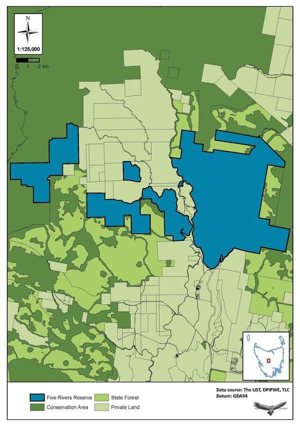
INTRODUCTION
The Tasmanian Land Conservancy
The Tasmanian Land Conservancy (TLC) is a non-profit, non‐political, private organisation that works towards
achieving sustainability and biodiversity conservation in Tasmania.

The TLC 2050 Mission

In partnership with other organisations, communities, individuals and governments, the TLC will:

    1        Take a lead role in building a landscape scale approach to conservation including a world‐class system
             of reserves complemented by sustainable development.
    2        Demonstrate excellence in management for biodiversity conservation.
    3        Contribute to Tasmania becoming a centre for knowledge and expertise for nature conservation and
             planning.
    4        Develop and implement innovative mechanisms for achieving sustainability and biodiversity
             conservation.
    5        Provide opportunities and mechanisms for communities and individuals to achieve conservation.
    6        Demonstrate organisational leadership through exceptional governance, a positive working
             environment and financial sustainability.
This management plan and the implementation of the strategies and actions within it, including monitoring and
reporting, contribute to the TLC achieving its mission.

The Five Rivers Project
In October 2010 the TLC purchased Skullbone Plains and 34 additional properties comprising over 28,000 hectares
of the Gunns Ltd native forest estate, in the largest private conservation purchase in Australia’s history - the New
Leaf Project. This purchase was made possible with the help of private philanthropists Jan Cameron, Rob and
Sandy Purves, Graeme Wood, the federal government’s National Reserve System (NRS) program and donations
from over 1,000 TLC supporters. These properties are now being managed for conservation through a variety of
mechanisms including permanent reservation and perpetual covenant.

The Five Rivers Project was established in 2012 as a partnership between the TLC, BHP Billiton and its global
alliance partner Conservation International, for the sustained conservation and management of a cluster of New
Leaf properties located in the Bronte region. The properties consist of Skullbone Plains, Viormy, Roscarborough,
Serpentine and Pine Tier Lagoon, which collectively span over 11,113 ha and embrace the tributaries of five river
systems: the Nive, Serpentine, Pine, Little and Little Pine rivers. This very important landscape, now called the Five
Rivers Reserve, contains open grassland valleys, old-growth forests and woodlands, native grasslands, cushion
plants, endangered sphagnum moss beds and habitat for threatened wildlife and important endemic species.

Skullbone Plains has now been included in the NRS and a conservation covenant was registered on the land title in
February 2013 under Tasmania’s Nature Conservation Act 2002. In 2013 Skullbone Plains was given World Heritage
Area status as an extension to the Tasmanian Wilderness World Heritage Area. A separate management plan was
prepared for Skullbone Plains in accordance with the NRS requirements and adopted in 2013. This plan has now
been incorporated into the Five Rivers Reserve Management Plan to ensure a coordinated conservation focus
across the entire region.

Five Rivers Management Plan 2014 - 2019                                                                         Page 4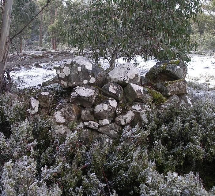
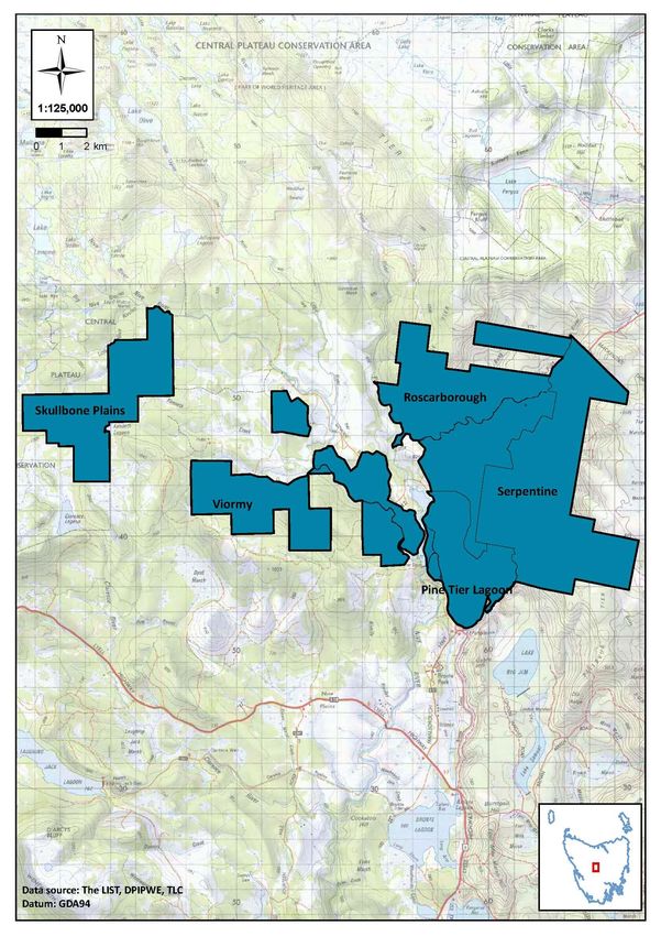
Five Rivers Reserve
The Five Rivers Reserve spans 11,113 ha of predominantly eucalypt forest and woodland interspersed with a rich
and diverse range of other alpine and sub-alpine vegetation communities and habitats of high conservation value.
The area embraces a network of natural and artificial freshwater systems and is the first location where water
enters private land from Australia’s only natural upland glacial lakes district. The Five Rivers Reserve has been
subject to various intensities of commercial timber harvesting in the past but still retains substantial areas of un-
logged and regenerating forest plus other priority forest types, grasslands, wetlands and non-forested areas such
as moorland, all in varying size and condition. These large and structurally intact forest patches contain functioning
ecosystems and vegetation communities expressed at a landscape scale.

Prior to the TLC taking ownership in 2010, the reserve comprised a total of 24 separate land titles all of which had
a range of property names (Table 1, Figure 1).

Table 1 Properties comprising the Five Rivers Reserve prior to TLC ownership in 2010.

Previous Property        Size       No of     Location and general description
Name                     ha         Titles

Skullbone Plains (also   1618.2     1         Skullbone Plains is included in Tasmania’s Wilderness World Heritage Area
known as Forbes)                              and adjoins the Central Plateau Conservation Area to the west and to the east
                                              is adjoined by State forest land and the Viormy property.
Viormy                   2265.5     8         This property includes parcels of land known as Viormy, Viormy Peninsula and
[includes Viormy                              Viormy Pine Tier Lagoon and is accessed off the Gowan Brae Road. They are a
Peninsula and Viormy                          cluster of almost fully forested blocks, close to Bronte Park, some adjoining
Pine Tier Lagoon]                             the Nive River and Pine Tier Lagoon. Surrounding land includes State forest
                                              and a significant boundary with the private ‘Pine Tier’ pastoral estate.
Roscarborough            2581.7     8         Large block accessed via the Marlborough Highway and traversed by the Little
                                              Pine River and Serpentine River. Gentle to medium to steep gradient with
                                              excellent views of valley and wide scenic vistas. Good access points to
                                              marshland and grassland and with diverse vegetation. Surrounding land
                                              includes State forest, Central Plateau Protected Area, and the privately owned
                                              ‘Gowan Brae’ and ‘Pine Tier’ estates.
Serpentine               3535.5     6         Large block accessed via the Marlborough Highway and traversed by the Little
                                              Pine River and Serpentine River. Gentle to medium to steep gradient with
                                              excellent views of valley and wide scenic vistas. Good access points to
                                              marshland and grassland and with diverse vegetation. Surrounding land
                                              includes State Forest, Top Marshes Conservation Area and the private
                                              ‘Highland Waters’ pastoral estate.
Pine Tier Lagoon         1113       1         Commences 2km north of Bronte Park township and is a topographically
                                              varying title, including extensive marshes and the forested, steep slopes and
                                              plateau of Great Pine Tier. The property is bounded to the west by Pine Tier
                                              Lagoon and to the south and east by the Serpentine Rivulet. The title
                                              encompasses Bawley’s Peak in the south, and a large section of Great Pine
                                              Tier. The Marlborough Highway dissects the property in the east. Smaller
                                              public roads pass through the property near the western boundary, providing
                                              public access to Pine Tier Lagoon and the adjacent private ‘Pine Tier’ estate.

Total                    11,113.9   24        Five Rivers Reserve

Five Rivers Management Plan 2014 - 2019                                                                                Page 5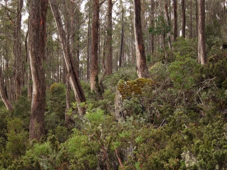
Location and tenure
The Five Rivers Reserve is located in Tasmania’s Central Highlands approximately 10 km east of Lake St Clair and 15
km northwest of Bronte Park, at latitude 42 02 28.21 S and longitude 146 20 23.79 E (Figure 1). The reserve
boundary extends from approximately 2 km north of the Bronte Park township and continues north along the
Marlborough Highway and to the west via the Gowan Brae Road. The reserve is situated at elevations ranging from
600 m to over 1,100 m and receives on average over 2,500 mm of rainfall per year, together with prolonged frost
and heavy snowfalls in winter.

The Five Rivers Reserve is owned by the TLC as private freehold land. Part of it is included within, and the
remainder adjoins, the Tasmanian Wilderness World Heritage Area. It has a range of other neighbouring land
tenures including State and private conservation reserves, State and privately managed forests, pastoral land,
private shacks, and hydro-electricity impoundments/lagoons (Figure 2). The reserve is within close proximity to
many well-known fishing and boating lakes and major access routes to the wider Central Highlands area.

Access
The main approach to the area is via the township of Bronte Park which is approximately 13.6 km northeast of
Derwent Bridge, 188 km north of Hobart or 188 km south of Launceston. There are multiple entry points to the
reserve off the Marlborough Highway or Gowan Brae Road via well roaded major arterial routes affording in most
cases 2WD access. Access crosses a range of land tenures and is gained via a network of roads and locked gates
which are managed by the TLC.

Bioregional and Landscape Context
IBRA
The Five Rivers Reserve occurs in the Tasmanian Central Highlands IBRA region.

Catchment values
The Five Rivers Reserve falls within the upper catchments of the River Derwent, which flows through to Hobart,
Tasmania’s capital city, and is one of the primary sources of water downstream for many agriculture, hydro power,
industry and domestic water supply purposes. Maintaining or enhancing the condition of these upper catchments
through conservation management will contribute to ecosystem function and help provide ecosystem services.

Regional values
The Five Rivers Reserve has excellent context with surrounding protected areas, which include shared boundaries
with the Walls of Jerusalem National Park and the Central Plateau Conservation Area and Protected Area, both of
which are contained within the Tasmanian Wilderness World Heritage Area. Other neighbouring properties include
State forest, which are managed for their forestry values, Top Marshes Conservation Area, and several private
titles including ‘Gowan Brae’ owned by the Tasmanian Aboriginal community.

Skullbone Plains forms the heart of a focal landscape as identified by a bio-regional planning process for Tasmania
carried out by the NRS’s Protected Areas on Private Land Program in 2009. Under this process, more than half of
Skullbone Plains Reserve (~950 ha) falls within the top 10% of the highest rated conservation areas in the State and
about 250 ha is in the top 1% of the State. The protection of Skullbone Plains Reserve secured over 70% of the
private land in this focal landscape.

Five Rivers Management Plan 2014 - 2019                                                                       Page 6
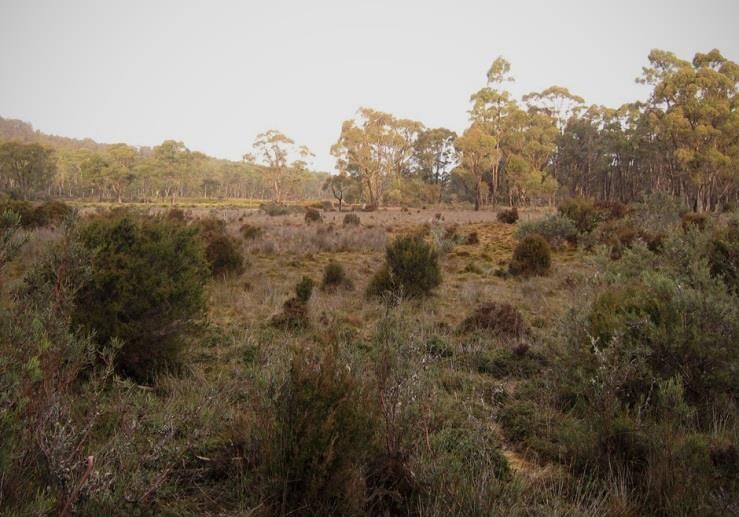
Figure 1 Location and property composition of the Five Rivers Reserve in Tasmania’s Central Highlands.

Five Rivers Management Plan 2014 - 2019                                                                  Page 7
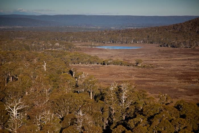
Figure 2 Range of land tenures surrounding the Five Rivers Reserve.

Five Rivers Management Plan 2014 - 2019                               Page 8
RESERVE STATUS IUCN Protected Area Management Category The Five Rivers Reserve meets the criteria for protected area management at two differing levels based on the quality and extent of natural values (Dudley 2008). Due to its outstanding natural values and landscape context the Skullbone Plains Reserve has World Heritage status and meets IUCN Protected Area Category IV. The Bronte properties meet IUCN Protected Area Category V. Skullbone Plains Reserve - Category IV - Habitat/Species Management Area Primary objective: To maintain, conserve and restore species and habitats. Other objectives: To protect vegetation patterns or other biological features through traditional management approaches; To protect fragments of habitats as components of landscape or seascape‐scale conservation strategies; To develop public education and appreciation of the species and/or habitats concerned; To provide a means by which the urban residents may obtain regular contact with nature. Bronte Properties - Category V - Protected Landscape Primary objective: To protect and sustain important landscapes/seascapes and the associated nature conservation and other values created by interactions with humans through traditional management practices. Other objectives: To conserve the composition, structure, function and evolutionary potential of biodiversity; Contribute to regional conservation strategies (as core reserves, buffer zones, corridors, steppingstones for migratory species etc.); Maintain diversity of landscape or habitat and of associated species and ecosystems; Be of sufficient size to ensure the integrity and long-term maintenance of the specified conservation targets or be capable of being increased to achieve this end; Maintain the values for which it was assigned in perpetuity; Be operating under the guidance of a management plan, and a monitoring and evaluation programme that supports adaptive management; Possess a clear and equitable governance system. Management of the Five Rivers Reserve will be in accord with these IUCN categories. Legal Status and Compliance In February 2013 a conservation covenant was registered on the property title of Skullbone Plains under Tasmania’s Nature Conservation Act 2002 (NC Act). This covenant has the force of a statutory document that binds the TLC to its provisions in perpetuity. A conservation covenant is now being prepared for the Bronte properties. In addition to the conservation covenant, the TLC could apply to the Tasmanian Government to have these areas declared a Private Nature Reserve under the NC Act. This will assist in ensuring that conservation management is consistent across the multiple tenures that exist in the area. In 2013 Skullbone Plains was added to the Tasmanian Wilderness World Heritage Area by UNESCO. Five Rivers Management Plan 2014 - 2019 Page 9
The Central Highlands Planning Scheme 1998 is the local government planning instrument covering this area and
any proposed developments may need to meet the requirements of this scheme and be assessed by the Central
Highlands Council.

Constraints may apply to activities which could adversely affect species and vegetation communities listed as
threatened under Australian and Tasmanian legislation, and special permits for works or research are required.
The Environment Protection and Biodiversity Conservation Act 1999 (EPBC Act) is the Federal Government’s
primary legislation which protects threatened species and ecological communities. Tasmania’s Threatened Species
Protection Act 1995 (TSP Act) lists species threatened in Tasmania and it is an offence to knowingly disturb or
destroy a listed species without a permit. Schedule 3A of the NC Act lists threatened native vegetation
communities and any disturbance to listed communities is regulated through revisions to Tasmania’s Forest
Practices Act 1985.

Five Rivers Management Plan 2014 - 2019                                                                  Page 10
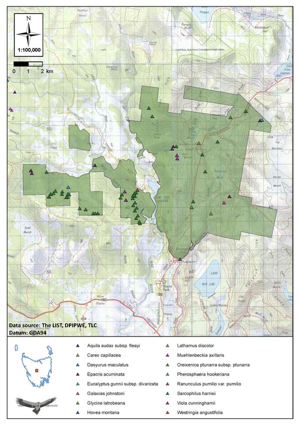
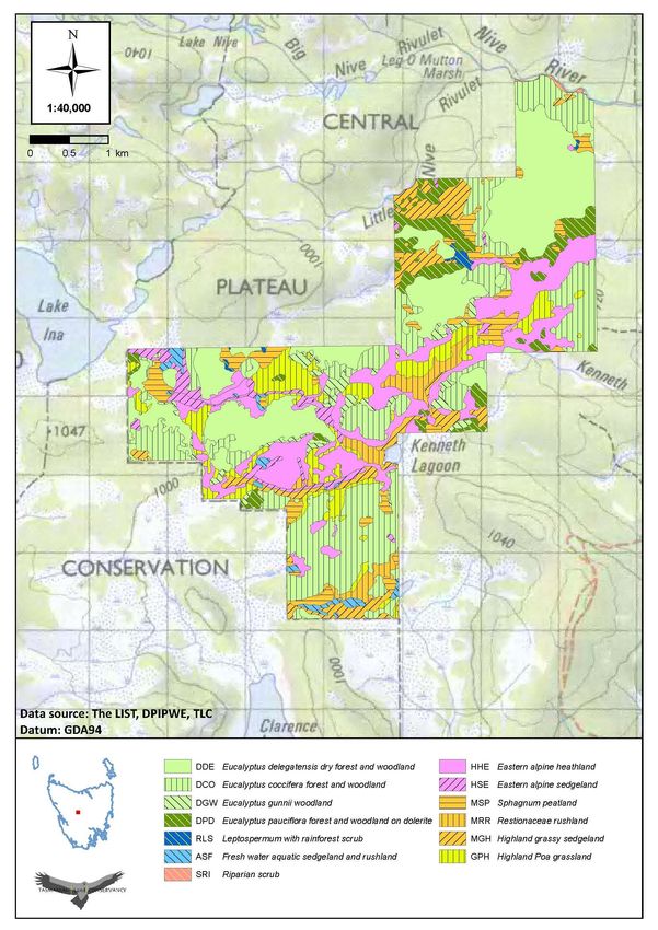
NATURAL VALUES

Vegetation Communities
The Five Rivers Reserve is predominantly a contiguous highland eucalypt forest ecosystem that is regenerating
after low intensity forest harvesting over the past 40 years. In addition to highland eucalypt forest there are a
number of non-forest vegetation communities of conservation significance, including threatened highland
grasslands and marshlands (Table 2, Figure 3, Figure 4). These are scattered across the reserve in low lying areas or
where poor drainage and heavy winter frosts inhibit the growth of forest vegetation. The distribution of vegetation
communities on Skullbone Plains is slightly different and largely controlled by drainage and frost. In areas where
neither drainage nor frost prevent establishment and survival then eucalypts dominate the vegetation to form
forests or woodlands. Where frost prevents trees from surviving, grasslands, moorlands and heathlands occur, and
where drainage is very poor, wetlands and aquatic systems dominate. Fire is an additional controlling factor to the
distribution of vegetation across the reserve, with the frequency and intensity of past fires limiting the re-
establishment of fire-sensitive vegetation. Highland Poa grasslands (listed as rare and endangered in Tasmania)
form a part of this native ecosystem.

Alpine sphagnum peat bogs are endangered nationally and these vegetation communities have been declining
across their entire range (Commonwealth of Australia 2009). Sphagnum bogs are extensive on Skullbone Plains in
areas where fire has been either absent or present with very low frequency and intensity. With the adjoining areas
that span Clarence Lagoon to Lake Ina, the Skullbone Plains region comprises one of the most extensive areas of
sphagnum bogs in Tasmania, including areas containing some scientifically unique ‘standing wave’ structures
unknown elsewhere in the world (Morgan et al. 2010). Smaller patches of Sphagnum occur in localised areas on
other parts of the Bronte properties.

Flora species of conservation significance
Preliminary surveys to date have identified a number of flora species of high conservation significance on the
reserve (Table 3). These predominantly occur in non-forest vegetation, especially grasslands (Figure 5, Figure 6).
The endemic nationally endangered Miena cider gum Eucalyptus gunnii subsp. divaricata, is restricted to
Tasmania’s Central Plateau and surveys undertaken in 2011 identified a stand of this species at McKenzies Tier
(TLC 2012). The population is in good condition with recruitment of seedlings and saplings occurring along with
healthy mature adult trees. Claspleaf heath Epacris acuminata occurs on the eastern edge of the Central Plateau in
subalpine heathy woodland exclusively on Jurassic dolerite (Threatened Species Section 2010). A small patch of
this nationally vulnerable heath was identified on a rocky escarpment below the Little Pine River in 2013, close to
the confirmed locality for the rare mountain purplepea Hovea montana. The nationally vulnerable clover glycine
Glycine latrobeana has been recorded along the Marlborough Highway and the state vulnerable drooping pine
Pherosphaera hookeriana occurs at several locations along the edges of the Nive River near Skullbone Plains. A
small population of the rare yellow leaf sedge Carex capillacea occurs on the wetter southern parts of Thompsons
Marsh and the upper reaches of Serpentine Rivulet (P. Collier survey 2013).

Five Rivers Management Plan 2014 - 2019                                                                       Page 11
Table 2 Vegetation communities on the Five Rivers Reserve (TasVeg mapping units).

Community (TasVeg code )                                                            Area     NCA      EPBCA
                                                                                     ha      status   status
Freshwater aquatic sedgeland and rushland (ASF)                                     15.48      e
Eucalyptus amygdalina forest and woodland on dolerite (DAD)                          7.56
Eucalyptus coccifera forest and woodland (DCO)                                      555.88
Eucalyptus dalrympleana – Eucalyptus pauciflora forest and                          530.91
woodland (DDP)
Eucalyptus delegatensis dry forest and woodland (DDE)                           4455.98
Eucalyptus delegatensis wet forest (WDU)                                             2.97
Eucalyptus gunnii woodland (DGW)                                                    62.05
Eucalyptus pauciflora forest and woodland on dolerite (DPD)                     2091.38
Eucalyptus pauciflora forest and woodland not on dolerite (DPO)                 1279.42
Eucalyptus rodwayi forest and woodland (DRO)                                        577.49
Highland Poa grassland (GPH)                                                        407.43    r, e
Eastern alpine heathland (HHE)                                                      139.11
Eastern alpine sedgeland (HSE)                                                      257.41
Highland grassy sedgeland (MGH)                                                     474.79     r
Restionaceae rushland (MRR)                                                         57.03
Sphagnum peatland (MSP) (TasVeg analog of Alpine Sphagnum Bogs)                     107.12     r       EN
Nothofagus – Leptospermum short rainforest (RML)                                     1.57
Nothofagus – Atherosperma rainforest (RMT)                                           3.71
Subalpine heathland (SHS)                                                           10.48
Water, sea (OAQ)                                                                     3.09
Leptospermum with rainforest scrub (RLS)                                             7.26
Riparian scrub (SRI)                                                                37.49      v
Leptospermum scrub (SLW)                                                            31.11
Extra-urban miscellaneous (FUM)                                                     10.69
Regenerating cleared land (FRG)                                                     37.09
TOTAL                                                                          11,137.55
EPBC EN, Listed as endangered under the Commonwealth EPBC Act 1999
NCA e, v, r Listed as endangered, vulnerable or rare under Tasmania’s NC Act 2002

Five Rivers Management Plan 2014 - 2019                                                                        Page 12
Figure 3 Vegetation communities on the Bronte properties of the Five Rivers Reserve (TASVEG). Five Rivers Management Plan 2014 - 2019 Page 13
Figure 4 Vegetation communities on Skullbone Plains in the Five Rivers Reserve (TASVEG).

Five Rivers Management Plan 2014 - 2019                                                    Page 14
Table 3 Flora species of conservation significance on the Five Rivers Reserve.

Species                            Scientific name                       Confirmed #   EPBCA   TSPA   Endemic
Miena cider gum                    Eucalyptus gunnii subsp.              Yes           EN      e      Yes
                                   divaricata
Claspleaf heath                    Epacris acuminata                     Yes           VU      -      Yes
Clover glycine                     Glycine latrobeana                    Yes           VU      v
Yellow leaf sedge                  Carex capilliacea                     Yes           -       r
Small alpine leek orchid           Prasophyllum tadgellianum                           -       r
Rayless starwort                   Stellaria multiflora                                -       r
Mountain purplepea                 Hovea montana                         Yes           -       r
Drooping pine                      Pherosphaera hookeriana               Yes           -       v      Yes
Narrowleaf westringia              Westringia angustifolia               Yes           -       r      Yes
Ferny buttercup                    Ranunculus pumilio subsp. pumilo      Yes           -       r
Grassland cupflower                Colabanthus curtisiae                 Yes           VU      r      Yes
Mount Mawson pine                  Pherosphaera hookeriana               Yes           -       v
Matted lignum                      Muehlenbeckia axillaris               Yes           -       r
Alpine violet                      Viola cunninghamii                    Yes           -       r
Fine frillyheath                   Pentachondra ericifolia               Yes           -       r      Yes
Handsome hooksedge                 Ucinia elegans                        Yes           -       r
Small star plantain                Plantago glacialis                    Yes           -       r
# confirmed: Yes sighted since acquisition, otherwise species recorded in the NVA
EPBCA: Listed as endangered EN or vulnerable VU under the Commonwealth EPBC Act 1999
TSPA: Listed as endangered e, vulnerable v or rare r under Tasmania’s TSP Act 1995

Small populations of the alpine violet Viola cunninghamii occur on the Viormy property and clover glycine Glycine
latrobeana and matted lignum Muehlenbeckia axillaris have been recorded at Bens Marsh. The ferny buttercup
Ranunculus pumilio subsp. pumilo – a rare herb species, has been confirmed across the reserve and the narrowleaf
westringia Westringia angustifolia has been identified near the Nive River on the boundary of Viormy.

In 2012 a comprehensive flora survey was undertaken on Skullbone Plains as part of the national Bush Blitz
program (http://www.bushblitz.org.au/, Bush Blitz 2014) and during this survey the tufted perennial sedge Uncinia
elegans and perennial herb Plantago glacialis were recorded there. In 2014 a second Bush Blitz survey was
undertaken across the Bronte properties, during which fine frillyheath Pentachondra ericifolia was identified on
Roscarborough and grassland cupflower Colabanthus curtisiae was identified near Thompsons Marsh, on
Serpentine. Information collected during the 2014 Bush Blitz survey is still being processed and will be available in
the future.

The small alpine leek orchid Prasophyllum tadgellianum has yet to be identified and NVA records dating from the
1980s need to be reconfirmed for rayless starwort Stellaria multiflora.

Five Rivers Management Plan 2014 - 2019                                                                         Page 15
Fauna species of conservation significance The Five Rivers Reserve supports populations of several conservation significant fauna species (Table 4, Figure 5, Figure 6). A total of 239 faunal species have been recorded on the reserve, which includes 15 species of mammal, 44 bird species, 8 reptile and 3 amphibian species. Skullbone Plains is key habitat for the nationally endangered Clarence galaxias Galaxias johnstoni, an endemic freshwater fish that occurs in several lagoons, marshes and streams in the Clarence, Nive and Little River sub-catchments. The Bronte region is a long-term monitoring site for the nationally endangered Tasmanian devil Sarcophilus harrisii. Regular trapping and spotlight transects by the STDP have monitored the movement of Tasmanian devils across this landscape and mapped the rate of spread of the lethal Tasmanian devil facial tumour disease (DFTD). Tasmanian devils are regularly recorded on the reserve, as are the nationally vulnerable spotted-tail quoll Dasyurus maculatus and the eastern quoll Dasyurus viverrinus. These three carnivorous marsupial species have been detected on roads, tracks and by using motion sensor cameras. The Tasmanian bettong Bettongia gaimardia has been identified on Skullbone Plains and its preferred habitat occurs more widely across the reserve. Historical records indicate that the nationally threatened eastern- barred bandicoot Perameles gunnii once occurred in the area but no recent sightings are known. The white-footed dunnart Sminthopsis leucopus is an IUCN Red List species that occurs in a variety of habitats from rainforest, open forest to dry coastal heath. This species has been recorded nearby at Liaweenie and potentially occurs in the reserve. The IUCN Red Listed and nationally vulnerable green and gold frog Litoria raniformis is predominantly a lowland species in Tasmania and while it is unlikely to occur on the reserve due to the high altitude, extension surveys are needed to confirm this. A number of bat species have been recorded on Skullbone Plains by Lisa Cawthen (pers. com) and possibly occur more widely across the reserve: Eastern falsistrelle Falsistrellus tasmaniensis, long-eared bat Nycotohphilus sp., Gould's wattled bat Chalinolobus gouldii and a forest bat Vespadelus sp. The extensive highland eucalypt forests support large hollow bearing trees which provide nesting habitat for threatened bird species such as the masked owl Tyto novaehollandiae and a number of other hollow dependent bird and mammal species. Five nests of the nationally endangered wedge-tailed eagle Aquila audax fleayi are known on the reserve. Two nests are now dilapidated and 3 nests are monitored on an annual basis including one nest that was newly discovered in 2013. The State threatened white-bellied sea-eagle Haliaeetus leucogaster regularly forages over water bodies a few kilometres to the south of the reserve and areas such as adjacent to Pine Tier Lagoon are suitable for breeding. Nesting habitat for the grey goshawk Accipiter novaehollandiae is abundant along rivers and riparian zones across the reserve and this species is occasionally seen foraging in the wetter forest margins. The nationally endangered swift parrot Lathamus discolor utilises forests across the reserve during its northward migration before crossing Bass Strait to overwinter on mainland Australia. More recently, a flock of six swift parrots were observed foraging on Viormy in April 2014. While the invertebrate fauna is less well known, the ptunarra brown butterfly Oreixenica ptunarra has been recorded in the past in several grasslands containing Poa tussocks near Bronte. In 2013 the endangered Miena jewel beetle Castiarina insculpta was identified in Ozothamnus hookeri habitat near Liawenee, so it is likely that future surveys may detect this species in suitable habitat on the reserve. During the national Bushblitz survey in 2012 a range of key invertebrate taxa were collected on Skullbone Plains. A total of 17 species of land snails, 30 species of chrysomelid beetles, 48 species of geometrid moths, 5 species of butterflies, 11 species of Odonata, 9 species of caddis flies, and 66 species of spiders were found. At least four new species of Tasmanian spiders were collected however this information was still being processed at the time of writing (http://www.bushblitz.org.au/). Five Rivers Management Plan 2014 - 2019 Page 16
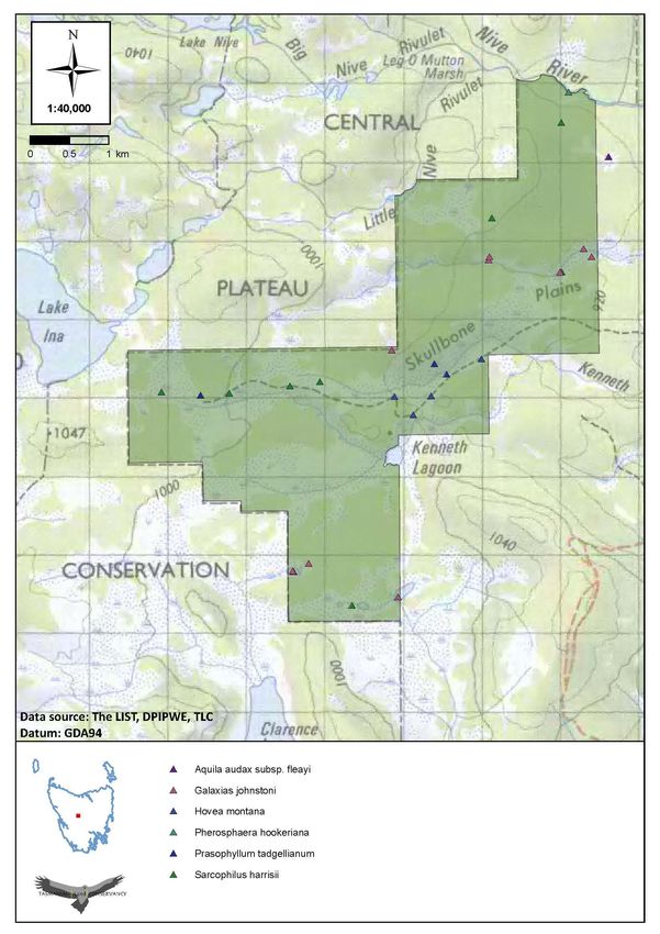
Table 4 Fauna species of conservation significance on the Five Rivers Reserve.

Species                         Scientific name                          Confirmed #   EPBCA   TSPA    IUCN
Tasmanian devil                 Sarcophilus harrisii                     Yes           EN      e
Spotted-tailed quoll            Dasyurus maculatus                       Yes           VU      r
Eastern quoll                   Dasyurus viverrinus                      Yes           -       -
White-footed dunnart            Sminthopsis leucopus                                   -       -       C2a(i)b
Eastern-barred bandicoot        Perameles gunnii                                       VU      -
Tasmanian bettong               Bettongia gaimardi                       Yes           -       -
Green and gold frog             Litoria raniformis                                     VU      v       A2ae
Clarence galaxias               Galaxias johnstoni                       Yes           EN      e
Wedge-tailed eagle              Aquila audax fleayi                      Yes           EN      e
Grey goshawk                    Accipiter novaehollandiae                              -       e
Masked owl                      Tyto novaehollandiae castanops                         VU      e
Swift parrot                    Lathamus discolor                        Yes           EN      e
White-bellied sea-eagle         Haliaeetus leucogaster                                 -       v
Ptunarra brown butterfly        Oreixenica ptunarra ptunarra                           EN      v
# confirmed: Yes sighted since acquisition, otherwise species recorded in the NVA
EPBCA: Listed as endangered EN or vulnerable VU under the Commonwealth EPBC Act 1999
TSPA: Listed as endangered e, vulnerable v or rare r under Tasmania’s TSP Act 1995
IUCN Red List

Figure 5 and Figure 6 show the current location of a range of threatened fauna and flora species known from the
Five Rivers Reserve. This information will change as more surveys are conducted. Some species, such as the
Tasmanian devil, are wider ranging than indicated by the map symbols.

Five Rivers Management Plan 2014 - 2019                                                                   Page 17
Figure 5 Threatened species records on the Bronte properties in the Five Rivers Reserve (includes 2013 NVA data). Some
species are more wide ranging than indicated by the symbols.

Five Rivers Management Plan 2014 - 2019                                                                            Page 18
Figure 6 Threatened species records on Skullbone Plains in the Five Rivers Reserve (includes 2013 NVA data).

Five Rivers Management Plan 2014 - 2019                                                                        Page 19
Geo-conservation values
The Five Rivers Reserve contains several features identified on the Tasmanian Geo-conservation Database
(http://www.dpiw.tas.gov.au) which are of geo-conservation significance. Parts of the reserve occur on the Central
Plateau Terrain or have sites containing Western Tasmania Blanket Bogs, both of which are of world significance.
The reserve is located within the Central Highlands Cainozoic glacial area, a geo-conservation site of Australian
significance and areas on the Serpentine property contain regionally significant sites of Great Pine Tier Tertiary
Fault Trace. Many of these geo features are easily degraded by activities such as inappropriate vehicle use, gravel
extraction, excavation or construction or other activities that lead to impeding water runoff and erosion.

The presence of three moraines at Skullbone Plains forms part of the Central Highlands Cainozoic Glacial Area,
which is listed as a nationally significant geo-conservation feature in the Tasmanian Geo-conservation Database.
These moraines are the Central Plateau Terrain, Clarence Lagoon String Bogs and the Western Tasmania Blanket
Bogs (DPIPWE Natural Values Atlas), all of which were significant during the last glaciation which peaked between
18,000 and 22,000 years BP (Forest Practices News 2006).

The Serpentine Rivulet is an example of an incised meandering stream.

Invasive Pest Species
There are a number of invasive weeds and feral fauna on the reserve. Weeds particularly scotch thistle
Onopordum acanthium, ragwort Senecio jacobaea, great mullein Verbascum thapsus and Californian thistle
Cirsium arvense are a legacy of stock grazing, soil disturbance and the movement of heavy machinery and vehicles
along roads and during commercial timber harvesting. Small localised outbreaks of gorse Ulex europaeus and
Californian stinkweed Navarretia squarrosa occur on the Reserve and canary broom Genista monspessulana is
known from neighbouring properties with a high probability of future invasion. Other small infestations of
Yorkshire fog Holcus lanatus, spear thistle Cirsium vulgare and the aquatic sedge Juncus articularis, have been
noted on roadsides and the Serpentine Rivulet.

Fallow deer Dama dama and European rabbit Oryctolagus cuniculus are widespread across the Central Highlands
including the Five Rivers Reserve and threaten the diversity of the grasslands and the regeneration of the
woodlands (Locke 2002). Fallow deer damage young and emergent vegetation and are also responsible for over-
browsing of grasslands and succulent grasses and herbs in marshland and wetlands. This invasive species is partly
protected in Tasmania and can only be destroyed under permit either during the recreational hunting season or
for crop protection purposes (crop can also include conservation assets).

Feral cats Felis catus occur on the reserve and are widespread in the region and regularly trapped by land
managers or shot by recreational hunters. A fox skull and several alleged sightings of the European red fox Vulpes
vulpes have been made in the Central Highlands near Interlaken (http://www.abc.net.au/news/2010-02-10/fox-
skull-found-in-central-highlands/326836) by members of the public and fox baiting has been undertaken by the
Tasmanian Government’s Fox-Free Task Force (DPIPWE). These two predators impact upon critical-weight range
mammals and birds and data is needed to determine their presence, density and most effective means of control.

Brown trout Salmo trutta are common in most of the waterways and larger water bodies on the reserve, many of
which are regularly stocked by the Inland Fisheries Service for recreational fishing. Brown trout Salmo trutta are
the primary threat to the endangered Clarence galaxias Galaxias johnstoni and have the potential to exterminate
local populations of this endemic fish species. There are several streams in which brown trout do not occur,
possibly due to surrounding moraine barriers and the marshy, braided nature of the wetland areas. It is critical to
ensure that brown trout do not expand their range in the Skullbone Plains area.

Five Rivers Management Plan 2014 - 2019                                                                      Page 20
While little is known of invasive invertebrate pests, the bumblebee Bombus terrestris and European wasp Vespula
germanica both occur on the reserve and are known to compete for nectar resources and can potentially impact
on threatened species. Information is lacking on these species.
Scientific Studies
There have been a number of scientific studies, surveys and monitoring activities undertaken on the Five Rivers
Reserve, or in the surrounding area, in recent times. These are:
National BushBlitz Survey 2014 Five Rivers Reserve (http://www.bushblitz.org.au/)
National BushBlitz Survey 2012 Skullbone Plains (Bush Blitz 2014)
Miena Cider Gum survey (TLC 2012)
Long-term monitoring of eagle nest sites (in collaboration with FPA and Gunns Ltd)
Skullbone Plains montane conifer monitoring (Fitzgerald 2012)
Aging of the sphagnum peat profile (Hope et al. 2013)
Wind-controlled linear patterning and cyclic succession in Tasmanian Sphagnum mires (Morgan et al. 2010)
Tasmanian Devil Facial Tumour Disease monitoring in the Bronte region (conducted by the STDP)
Endangered Clarence Galaxias annual monitoring program (IFS and Threatened Species Section 2006)
Fallow Deer Monitoring (Locke 2002)
Endangered Miena Jewel Beetle surveys (surveys by Tasmanian Field Naturalists in 2013,
www.threatenedspecieslink.tas.gov.au/miena-jewel-beetle-discovery)
Microbial diversity in Australian soils (Bioplatforms Australia, CSIRO Plant Industry, Canberra)
Macro-invertebrate sampling in the waterways (NRM North supported program)
Preliminary acoustic survey of bats (L. Cawthen UTAS School of Zoology)
References are provided in this plan and more information on these studies is available from the TLC.
Five Rivers Management Plan 2014 - 2019 Page 21CULTURAL VALUES The traditional aboriginal owners of the area around the Five Rivers Reserve were the Big River nation, with the Trowutta and the Larmairrermener clans most closely associated with it. The families and clans were resident in this area during the warmer months of the year, travelling down to the lowlands of the Derwent River valley in the cooler months. Aboriginal heritage surveys have yet to be undertaken on the reserve. However, evidence of aboriginal occupation including artefact scatters has been found at several sites. With European settlement, farms were established and traditionally stock was driven up to the central highlands to rest the lowland paddocks during the summer months. A series of accommodation paddocks were provided on- route where the sheep were held overnight. Some of the paddocks are still used today when sheep are driven from farms near Ouse and Bothwell to highland locations surrounding the reserve like Liawenee Moor for the summer. Several homesteads, sheds, shack and hut sites are known throughout the reserve, as well as evidence of outbuildings, camp-grounds and disused tracks. The Roscarborough homestead was a well-known historic landmark which was destroyed by fire a decade or so ago. Stone chimneys, stone and wooden fences, shepherd and trappers huts persist in various states of decay reflecting past uses of the area. Protecting these cultural sites is an important component of managing this reserve for the Tasmanian community. The neighbouring land to the west and north of Skullbone Plains was gazetted as the Central Plateau Conservation Area in 2001, and forms part of the Tasmanian Wilderness World Heritage Area. Lake Ina, which is contained within the World Heritage Area and managed by the Tasmanian Parks and Wildlife Service, is a key focal point for public recreation, with the primary activities including bushwalking, camping and trout fishing. Past and Current Management The properties of Skullbone Plains, Serpentine and Roscarborough properties were purchased by Tasmanian Board Mills Ltd in the 1950s for timber extraction then changed ownership to Forest Resources, Boral Timber and then Gunns Ltd. In the late 1980s Forest Resources purchased the Viormy property from the Viormy family and the Pine Tier property in lieu of forest operations on London Marshes. Except for a small area of about 50 ha that was clear- felled on the Serpentine property, the typical extraction method used was selective logging, originally sourcing timber for saw logs but from the 1970s onwards also for woodchip. The TLC acquired the Five Rivers Reserve in 2010 from Gunns Ltd and now manages the area specifically for biodiversity conservation, carbon sequestration and the maintenance of ecosystems services. There are a number of user groups who retain a strong desire to access the area and therefore facilitating visitation remains a priority. Recreational Use Recreational access to Lake Ina has been via the Lake Ina Track, a rough 4WD track that traverses through the middle of Skullbone Plains. The challenging nature of this track, and the previously unrestricted access, has resulted in track degradation and numerous additional side tracks being created in an ad-hoc fashion. Several huts are known in the region, and these have mainly been developed by avid bushwalkers and fishers. Members of the Bronte Deer Stalkers use parts of the reserve on a seasonal basis for the recreational shooting of fallow deer. Prior to TLC taking ownership of the reserve the group also shot native wallaby and possum but this is no longer permitted. The group have constructed a small shack on Roscarborough for member use and are permitted to gather small quantities of firewood for use at the site. The Five Rivers region is a central point for recreational fishers and bushwalkers to access the Central Plateau Protected Area and the many walks and fishing lakes within the local region. Various four-wheel drive clubs of Tasmania and ‘Tas Trail’ have also sought to cross the reserve to access destinations such as Lake Olive and Circle Marsh. Five Rivers Management Plan 2014 - 2019 Page 22
RESERVE MANAGEMENT FRAMEWORK
Management Plan Vision: The Five Rivers Reserve should be managed for the biodiversity values that most
depend on it for their survival.

Adaptive Management
The TLC protects important natural areas as permanent reserves. A mission of the TLC is to demonstrate
excellence in management for biodiversity conservation. To achieve this mission the TLC has adopted the Open
Standards for the Practice of Conservation, which is an international system of adaptive management developed
by the Conservation Measures Partnership for use in conservation projects
(http://www.conservationmeasures.org). The Open Standards provide a guide to planning and implementing
conservation actions. The model of adaptive management used by the Open Standards is shown in Figure 7.

The TLC uses Miradi project management software for reserve management planning, monitoring, evaluation and
reporting. The software was developed by the Conservation Measures Partnership for use in conservation and land
management. Miradi provides the TLC with a tool to prioritize threats, develop objectives and actions, and select
monitoring indicators to assess the effectiveness of our management strategies. Miradi also provides a toolkit for
storing and using monitoring data and links monitoring data to specific reserve management objectives. The
integration of a planning process and a monitoring database makes Miradi a powerful adaptive management tool.

Figure 7 Open Standards adaptive management model, developed by the Conservation Measures Partnership (CMP).

Conservation Action Planning
This management plan represents the outcomes of the first and second stages of Conservation Action Planning,
using the Open Standards adaptive management model. Conservation targets have been selected that describe
broad ecosystem classes or habitat types, often with nested targets that are dependent upon the protection of the
primary target (e.g. critical populations of a grassland dependent species are notable as a target, yet are wholly
dependent upon the primary target and so are not selected as an independent target). Consistent ecological
indicators are selected for each target to monitor changes in the condition of the targets. Threats to each of the
targets are then identified, along with the factors that contribute to the threats, and these are prioritised
depending on the extent, likelihood and severity of the impact of these threats to the conservation targets.

Five Rivers Management Plan 2014 - 2019                                                                        Page 23
Strategies to manage these threats are developed, with consideration given to their environmental, social and economic feasibility of each strategy. Implementation of Management Strategies Strategies to mitigate the threats to conservation targets are assessed for their feasibility and prioritised based on a combination of factors. These include likelihood and extent of mitigating the threat, the resources required and the resources available to implement the strategy. Five‐year work plans are subsequently developed for each property to implement the management strategies. These work plans identify specific activities to be undertaken, the timing of these and the resources required. Work plans also allocate budgets, allowing the TLC to plan ahead to ensure appropriate capacity to deliver reserve management activities. Ecological parameters are also considered when scheduling works, to ensure that projects are undertaken when they are most likely to succeed. Progress against activities in the work plan is reviewed annually. Monitoring and Evaluation The TLC implements a monitoring and evaluation strategy across all of its permanent reserves. Monitoring of specific ecological indicators enables the collection of scientifically robust information on the status and trends of the conservation targets. Measuring the success of management actions is also critical for ensuring successful long-term management of the targets. A monitoring and evaluation plan is prepared for each reserve, and describes how each of these monitoring streams is delivered at the reserve. The TLC Monitoring and Evaluation Framework has four types of monitoring conducted at intervals ranging from 1 to 5 years: Long-term ecological monitoring will establish baseline measures of ecological indicators and subsequently provide early warning of deleterious changes in the conservation targets. The results of this monitoring allow reserve managers to develop mitigation measures and reduce future costs of remedial management. Annual reserve assessments are undertaken by TLC reserve management staff across all permanent reserves to identify any new or emerging threatening processes that have the potential to reduce the viability of the targets. Early identification of threats allows early management interventions to mitigate a threat. Management effectiveness evaluation provides land managers with information that is essential to determine the adequacy of management efforts. Data are collected on management inputs and biodiversity outputs, with indicators selected that are specific to measuring the success of management strategies. This information is then used by TLC reserve managers to make better-informed decisions on land management, measure progress towards performance objectives and determine the effectiveness of management strategies. Change detection analysis of remote sensing data using GIS, is undertaken to assess the impact of management strategies on vegetation cover. The surrounding region is also assessed to identify changes in land cover that could indicate threatening processes that have the potential to impact on a reserve. This wider analysis provides an indication of any ‘leakage’ – shifting of threatening process from a reserve to surrounding areas. Where this is identified, the TLC works with neighbouring landholders to develop local or regional mitigation strategies. Reporting The results obtained from the monitoring program are used to adapt and direct on-ground works programs and update annual work plans and reserve management plans. The status of conservation targets, trends in ecological indicators and outcomes of reserve management activities are communicated to the TLC Board and TLCs Science Council, stakeholders and the community through a range of regular communication channels including an annual report. Five Rivers Management Plan 2014 - 2019 Page 24
MANAGEMENT PLAN STRATEGY

CONSERVATION TARGETS                      GOALS
Highland Marshes                          Maintain or improve the floristic diversity of Highland Marshes
                                          Maintain or improve the structural complexity of Highland Marshes
                                          Maintain recruitment of Miena cider gum
                                          Maintain the extent of Sphagnum Peatland
                                          Maintain or improve the vertebrate fauna diversity of Highland Marshes
Streams and Wetlands                      Maintain the diversity of aquatic biota
                                          Maintain or improve floristic diversity of streams and wetlands
                                          Maintain or improve structural complexity of streams and wetlands
                                          Maintain or improve vertebrate fauna diversity in streams and wetlands
                                          Maintain populations of drooping pine Pherosphaera hookeriana
                                          Maintain or increase populations of Clarence galaxias
Highland Forest and Woodland              Maintain or improve floristic diversity of Highland Forests and Woodlands
                                          Maintain or improve structural complexity of Highland Forests and Woodlands
                                          Maintain or improve recruitment of canopy sp. of Highland Forests and Woodlands
                                          Maintain of Highland Forests and Woodland forest cover within 2% of 2010 baseline
                                          Maintain or improve vertebrate fauna diversity of Highland Forests and Woodlands
Carnivorous Marsupials                    Maintain wild, free ranging populations of carnivorous marsupials
Ecosystem Services                        Maintain or enhance all ecosystem services

SOCIAL TARGETS                            GOALS
Community Connection with the             Provide ways for people to achieve and enjoy the benefits of conservation
Landscape                                 Harness knowledge of the Bronte landscape to enhance management and support
                                          healthy communities
Cultural Heritage Values                  Protect, enhance and rediscover the cultural heritage values of the reserve
Regional Capacity                         Find ways to generate revenue and to enhance regional capacity
STRATEGIES                                OBJECTIVES
Build Resilience to Climate Change        Ecological monitoring ensures new management actions are implemented
Access Management                         Unauthorised access is reduced by 80% by 2020
Fire Management                           No unauthorised fires start on the reserve by 2020.
                                          All reasonable measures are taken to prevent the spread of any fires originating on
                                          the reserve
Clarence Galaxias Protection              No introductions or expansion of brown trout on the reserve
Threatened Species Protection             Improved conservation outcomes for threatened species by 2016
Carnivorous Marsupial Management          Improved management of native carnivorous marsupials
Feral and Domestic Animal Management      By 2016 distributions of key feral species are mapped and management strategies
                                          identified
Weed Management                           Existing infestations of weeds are eradicated from the reserve by 2017
Visitor Management                        People are encouraged to visit the reserve every year and are complying with TLC
                                          policies
Enhance Regional Capacity and Ecosystem   Ecosystem service derived income supplements reserve costs by 10% annually and
Services                                  contributing to the local Bronte community
Neighbour Relations                       Regular communications are maintained with all neighbours
Protect Cultural Heritage Sites           By 2016, cultural heritage sites are documented and a protection strategy planned
Community Engagement                      Increasing number of people accessing the reserve are engaged in TLC activities

Five Rivers Management Plan 2014 - 2019                                                                             Page 25
CONSERVATION TARGETS Highland Marshes Conservation priority: High Description Highland marshes typically occur in valleys where impeded drainage and severe frosts restrict the growth of most tree species. Seven TASVEG communities are grouped under this conservation target – Eucalyptus gunnii woodland (DGW), Eucalyptus rodwayi woodland (DRO), Highland Poa grassland (GPH), Eastern alpine heath (HHE), Eastern alpine sedgeland (HSE), Highland grassy sedgeland (MGH), Restionaceae rushland (MRR), Sphagnum peatland (MSP), Subalpine heathland (SHS) and Leptospermum scrub (SLW). GPH, MGH and MSP are listed as threatened communities under the NCA 2002, and MSP is also listed as threatened under the EPBCA 1999. Highland marshes are floristically diverse, and perform important ecological functions related to water cycling and carbon sequestration. They act as natural filters to water runoff, and by absorbing rainfall and slowly releasing it they reduce erosion and the severity of flooding events. The diverse shrubs that occur in these areas flower for an extended period over summer and provide an important food resource for migratory and resident bird species, and insectivorous species in particular. Wetter areas provide habitat for frogs and provide breeding habitat for many invertebrate species. Nested targets Highland Grassland Highland grassland occurs in areas with better drainage and soils derived from dolerite. The diversity of herbaceous taxa in this vegetation type is of particular conservation significance and several threatened plant species occur in grassland areas. The highland grasslands provide potential habitat for the Ptunarra brown butterfly and support a high abundance of marsupial herbivores and carnivores. Sphagnum Peatland Sphagnum peatland occurs in small scattered areas across the Five Rivers Reserve, with a significant wave patterned community occurring on Skullbone Plains. Sphagnum peatland occur in areas with impeded drainage, or where springs bring water to the surface, and perform important functions in water and carbon cycles. The dense soils and vegetation regulate stream flows by storing and slowly releasing water into the headwaters of river systems. Significant amounts of carbon are stored in the deep organic soils ansd vegetation which can accumulate over thousands of years. Miena Cider Gum The Miena Cider Gum (Eucalyptus gunnii subsp. divaricata) is an endangered eucalypt species that is endemic to the central plateau of Tasmania. It occurs in frost-hollows and is regarded as the most cold tolerant of all eucalypts. The past 20 years has seen a significant decline in the species due to a combination of drought and grazing by stock and other browsers. A population of Miena Cider Gum on Mackenzie’s Tier was assessed in 2011 and found to be in good condition. The population contained large mature trees, saplings and many seedlings, which indicates it has been reproducing successfully over a long time period (TLC 2012). Five Rivers Management Plan 2014 - 2019 Page 26
You can also read