2018-2021 MUNICIPAL FIRE MANAGEMENT PLAN - Wodonga Council
←
→
Page content transcription
If your browser does not render page correctly, please read the page content below
MUNICIPAL FIRE
MANAGEMENT PLAN

2018-2021
Wodonga Municipal Fire Management
Plan 2018-2021 is a sub-plan of
the Wodonga Municipal Emergency
Management Plan 2018-2021
The Wodonga Council Municipal Fire Management Committee (MFMPC) is responsible for providing a
strategic and integrated approach to fire management within the Wodonga municipality. This task
forms part of a broader state and regional framework established under the Emergency Management
Act (1986) and is supported by the State Fire Management Planning Committee and the Hume
Regional Strategic Fire Management Planning Committee (Hume RSFMPC). On behalf of my fellow c
Wodonga
a draft Municipalcommunity, Iw
A key responsibility of the Wodonga MFMPC is the development of
On behalf of my fellow
Fire Management
co
the firefighters
Plan (MFMP) on behalf of the Wodonga Council Municipal Emergency Management Planning
and sup
Committee for considered endorsement by Wodonga Council. This On behalf
Wodonga
plan, of my
community,
which aligns with fellow
the Icou
wo
Hume Regional Strategic Fire Management Plan 2011-2021, describes Victoria Police,
how regional SES, Dep
authorities,
local government, fire agencies and other relevant organizations Wodonga
thecan work community,
firefighters
together and suppo
to effectively I wo
and
anticipate, respond to and recover from bushfire events affecting Wodonga. Primary Industries,
the firefighters
Victoria Police, and SES,suppo
Depa
Services, North East Wa
Victoria
and Primary Police, SES,
Industries,
While the management of all types of fires is important, this plan has focused on bushfire in the
Depa D
involved in that
battling
first instance. The life of this plan is for three years and it is envisaged that future updates of this
and Primary Industries,
theDe
plan will include planning for other types for fire. Furthermore it Services,
is important North
to note East
this plan Wate
recognises, but does not duplicate, the extensive work already being this week.
undertaken
Services,
involved in
in fire
North
management
battlingEastthe WateW
across the municipality. This document is essentially a plan for improving integration of this existing
work and developing improved methods for working together.
involved
this
I wouldweek. in
alsobattling
like tothe W
ackn
I join with the members of the Wodonga MFMPC in commendingthis week.
the development and implementation of this plan as importantIstep
who
would ably
this document
also
in the ongoing
supported
to you. We see
liketoto ackno
journey
eme
securing a safer, more resilient community, healthier environmentresources
Iwho
and a prosperous and
would ablyalso like expertise
economy
supported
for our
to acknow
emer
municipality.
Mark Verbaken
who
Their ably
resources supported
and expertise.
forethought, emerg
their
Chairperson resources
determination and expertise.
and their
Wodonga Municipal Fire Management Planning Committee Their forethought, their p
ensured
Their the best
forethought,
determination possib
andtheirtheirpli
of one of
determination
ensured the thebestmost immi
andpossible
their im
ofcommunity
ensured
one ofthe has
thebest
most faced
possible
immin fo
ofAone
big of
community thank thehasmost
youfacedtoimmine
for
those
community hasto faced for
Aup bigtheir
thank time you toprotect
those v
A
upto
bigour
theirthanklocal
time media
youto to whoov
those
protect h
up
tomessages.
theirlocal
our timemediato protectwho he ou
to our local media who he
messages.
And thank you to our res
messages.
understanding
And thank you toand ourco-o
resi
time.
And thank you to
understanding and our resid
co-ope
understanding
time. and co-ope
We would like to take th
Inside cover images: Mark Slater CFA time.
We wouldtolike
people visittoemergen
take this
We
people
how wouldtotobe like
visit toemergency
fire take this
ready
Wodonga Municipal Fire Management Plan
this
people
how to to bevisit emergency
fire ready this s
A sub-plan of the Wodonga Municipal Emergency Management Plan 2018-2021

Version Control

Version Number      Date of Issue   Author(s)          Brief Description of Change

Version 1.0                         S.Hugenin          Draft MFMP initiated for comment
Version 2- Draft    Sept 2012       MFPC               Draft input from MFPC
Version 3 - Draft   Jan 2013        MFMPC              Draft following public comment
Version 4           April 2013      MFMPC              Final Version
Version 5 - Draft   May 2018        MFMPC              Draft Review/Rewrite of MFMP
FINAL DRAFT         August 2018     P. Leddy           Final Draft

Summary of revisions (Version 5 May 2018)

Section 1           Summarised current fire management planning arrangements and process.
Section 2           Updated stakeholder list and consultation process.
Section 3           Revised environmental scan, added maps.

                    Deleted strategic implications section (information included as part of VFRR).
Section 4           Updated fire management objectives consistent with state, regional and
                    local plans.
Section 5           Updated risk assessment process to detail VFRR–B.

                    Added a summary of all key stakeholder fire management activities.
Section 6           Revised the monitoring and evaluation, review, reporting and continuous
                    improvement to reflect current process.
Appendix A          Added VFRR-B risk criteria matrices.
Appendix B          Added VFRR-B tables and maps for human settlement, economic, cultural
                    heritage and environmental assets.
Appendix C          Added reference to electrical line clearance plan.
Appendix D          Remove list of roads managed for fire, refer to road management plan.
Appendix E          Updated glossary and acronyms.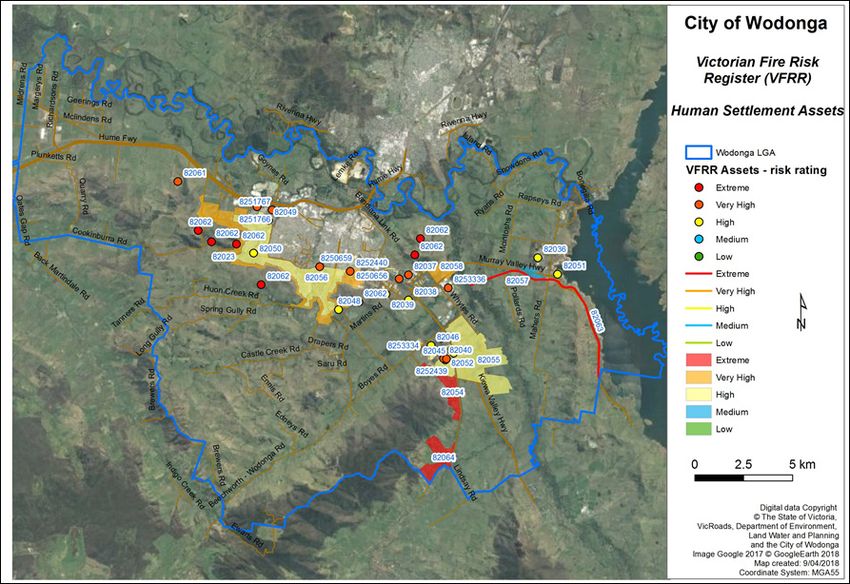
This integrated Municipal Fire Management Plan (MFMP) was adopted as the first iteration of the
Wodonga MFMP. This plan was endorsed through a formal motion by the Wodonga Municipal Fire
Management Planning Committee (MFMPC) at their meeting on August 13, 2018, for which the
chairperson of the committee will sign for and on behalf of all members of the Wodonga MFMPC.

Signed:
Date:
Mark Verbaken
Chairperson
Wodonga Municipal Fire Management Planning Committee

This MFMP was endorsed as a sub plan to the Wodonga Municipal Emergency Management Plan
through a formal motion by the Wodonga Municipal Emergency Management Planning Committee
(MEMPC) at their meeting on August 14, 2018, for which the chairperson of the committee will sign
for and on behalf of the members of the Wodonga MEMPC.

Signed:
Date:
Mark Verbaken
Chairperson
Wodonga Municipal Emergency Management Committee

This MFMP was adopted through a formal motion by Wodonga Council as the MFMP for Wodonga, at
their meeting on October 15, 2018, for which the Chief Executive Officer will sign for and on behalf of
Wodonga City Council.

Signed:
Date:
Patience Harrington
Chief Executive Officer
Wodonga Council

                                                          Wodonga Municipal Fire Management Plan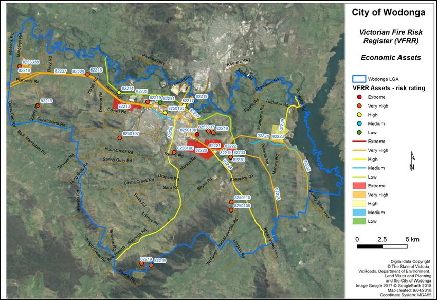
The responsibilities and accountabilities attributed to the organisations represented at the Wodonga
MFMPC are endorsed by:

Signed:                                            Signed:
Date:                                              Date:
Adrian Gutsche                                     Kevin Haggerty
District 24 Operations Manager                     Base Support Officer
Country Fire Authority                             Department of Defence

Signed:                                            Signed:
Date:                                              Date:
Jarrod Hayse                                       Ant Packer
Ovens Fire District Manager                        Community Ranger
Department of Environment, Land, Water             Parklands Albury Wodonga Ltd
and Planning
1   INTRODUCTION.............................................................................................................................................3
    1.1 Authority for the plan..........................................................................................................................4
    1.2 Period of plan........................................................................................................................................ 4
    1.3 Planning process ..................................................................................................................................4
2   ENGAGEMENT AND COMMUNICATIONS..................................................................................................6
    2.1 Stakeholder analysis...........................................................................................................................8
3   ENVIRONMENTAL SCAN .......................................................................................................................... 13
    3.1 Municipal Profile ............................................................................................................................... 13
          3.1.1 Land tenure .............................................................................................................................. 13
          3.1.2 Population and Demographics ........................................................................................... 14
          3.1.3 Land Use, Economy and Infrastructure ............................................................................ 15
          3.1.4 Natural Environment.............................................................................................................. 15
          3.1.5 Cultural heritage .................................................................................................................... 17
          3.1.6 Climate ..................................................................................................................................... 17
          3.1.7 Fire weather ............................................................................................................................ 17
          3.1.8 Fire History .............................................................................................................................. 20
4   MUNICIPAL FIRE MANAGEMENT OBJECTIVE ...................................................................................... 21
    4.1 Municipal Objective .......................................................................................................................... 21
    4.2 Strategic Direction ........................................................................................................................... 21
    4.3 Alignment of Regional and Municipal Objective ....................................................................... 21
5   FIRE MANAGEMENT RISK STRATEGIES ................................................................................................ 23
    5.1 Risk identification ............................................................................................................................ 24
    5.2 Risk analysis ...................................................................................................................................... 24
    5.3 Risk evaluation .................................................................................................................................. 25
    5.4 Risk Management Strategy ........................................................................................................... 25
          5.4.1 Municipal wide treatments ................................................................................................. 25
          5.4.2 Asset specific treatments ................................................................................................... 26
    5.5 Agency specific risk mitigation programming ......................................................................... 27
          5.5.1 Wodonga Council .................................................................................................................... 27
          5.5.2 Country Fire Authority .......................................................................................................... 31
          5.5.3 Department of Environment, Land, Water and Planning .............................................. 32
          5.5.4 Parks Victoria .......................................................................................................................... 36
          5.5.5 Parklands Albury Wodonga (PAW) ...................................................................................... 36
          5.5.6 Victoria Police ......................................................................................................................... 36
          5.5.7 VicRoads ................................................................................................................................... 37
          5.5.8 North East Water .................................................................................................................... 37
          5.5.9 Goulburn Murray Water ......................................................................................................... 37
          5.5.10 North East Catchment Management Authority ........................................................... 38

                                                                                         Wodonga Municipal Fire Management Plan                                    1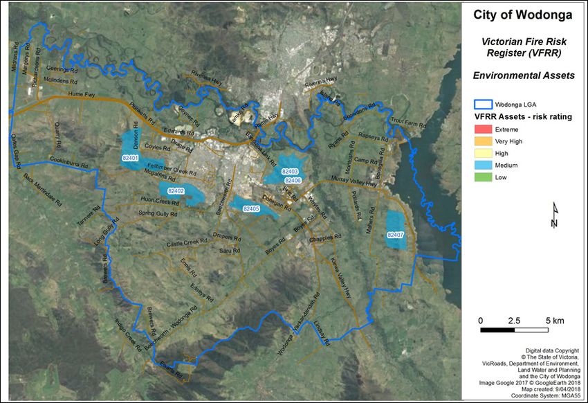
5.5.11 AusNet Services .................................................................................................................. 38
6 IMPROVEMENT AND PLAN REPORTING AND REVIEW PROCESS .................................................... 39
6.1 Monitoring and evaluation ............................................................................................................. 39
6.2 Review ................................................................................................................................................. 39
6.3 Reporting ............................................................................................................................................ 39
6.4 Continuous improvement ............................................................................................................... 39
APPENDIX A VFRR MATRICES ................................................................................................................................ 40
APPENDIX B WODONGA BUSHFIRE RISK REGISTER ......................................................................................... 41
AB.1 Human Settlement assets .......................................................................................................... 41
AB.2 Economic assets ............................................................................................................................ 43
AB.3 Cultural Heritage assets .............................................................................................................. 45
AB.1 Environmental assets ................................................................................................................... 47
APPENDIX C HAZARD TREES - IDENTIFICATION AND NOTIFICATION PROCEDURES ................................ 49
APPENDIX D FUEL REDUCED CORRIDORS AND PRIORITY ACCESS ROADS ................................................. 54
AD.1 General ............................................................................................................................................. 54
AD.2 Fuel Reduced Corridors ................................................................................................................. 54
APPENDIX E ATTACHMENT 6 : GLOSSARY & ACRONYMS ................................................................................ 54
AE.1 Glossary ............................................................................................................................................ 56
AE.2 Acronyms .......................................................................................................................................... 59
Table of Figures
Figure 1: Overview of Victoria’s emergency management planning committee structure (EMV, 2011..................3
Figure 2: Emergency management planning process (EMV, 2011)....................................................................................5
Figure 3: City of Wodonga municipality................................................................................................................................ 13
Figure 4: Age groups of the Wodonga population, 2016 Census (ABS, 2017)............................................................. 14
Figure 5: City of Wodonga Ecological Vegetation Classes............................................................................................... 16
Figure 6 : Bushfires in the Wodonga municipality 1940 - 2017 (DELWP, 2018)........................................................... 20
Figure 7: Alignment of MFMP & RSFMP Objectives............................................................................................................ 22
Figure 8: AS/NZS ISO 31 000-2009 risk management process. Source (CFA, 2017)................................................. 23
Figure 9: Asset classes and subclasses. Source (CFA, 2017).......................................................................................... 24
Figure 10: VFRR-B Risk and Priority Ratings. Source (CFA, 2017)................................................................................... 25
Figure 11: Community Information Guides and Neighbourhood Safer Places............................................................ 30
Figure 12: Location of CFA Fire Stations within Wodonga................................................................................................ 31
Figure 13: DELWP Fire Management Zones........................................................................................................................... 33
Figure 14: History of planned burns (1972 - 2018)............................................................................................................. 34
Figure 15: Designated Bushfire Prone Area and Bushfire Management Overlay........................................................ 35
Figure 16: Victorian Fire Risk Register - Human Settlement Assets............................................................................. 42
Figure 17: Victorian Fire Risk Register - Economic Assets............................................................................................... 44
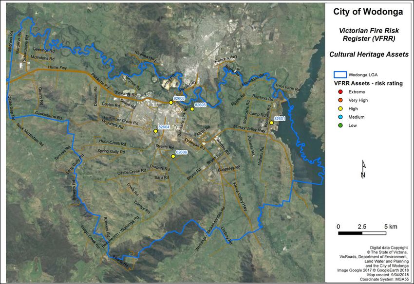
Figure 18: Victorian Fire Risk Register - Cultural Heritage Assets................................................................................. 46
Figure 19: Victorian Fire Risk Register - Environmental Assets...................................................................................... 48
2
Fire management planning in Victoria is undertaken to ensure adequate management of all aspects
of fires from prevention through to response and recovery. It brings together a range of agencies
and organisations to discuss, plan and manage fire with the community. It aims to provide quality
outcomes for communities at risk.
The Wodonga Municipal Fire Management Committee (MFMPC) is responsible for providing a strategic
and integrated approach to fire management within the Wodonga municipality. This task forms
part of a broader state and regional framework established under the Emergency Management Act
(1986) and is supported by the State Fire Management Planning Committee and the Hume Regional
Strategic Fire Management Planning Committee (Hume RSFMPC). MFMPCs are a sub-committee of
        Emergency Management
their respective   MunicipalManual Victoria Management Planning Committee. Part 6A: Guidelines for
                             Emergency
Municipal Fire Management Planning, of the Emergency Management Manual of Victoria, outlines the
terms of reference for these committees, identifies their minimum core membership and requires the
development of a Municipal Fire Management Plan (MFMP).
An overview of theGovernance
                   state’s emergency
                             & Planning management planning structure is provided in Figure 1, below.
                                                        Advisory

                       Security and Emergencies
                         Committee of Cabinet

                                State Crisis and                       Ministerial Advisory        Volunteer     Municipal Emergency
                                                                         Committee on             Consultative      Management
                               Resilience Council                                                                Enhancement Group
                                                                       Emergency Services           Forum

              Risk and           Capability and        Relief and          Emergency
              Resilience           Response            Recovery             Services
                                                                           Leadership
            Sub-committee        Sub-committee       Sub-committee
                                                                             Group

              State Fire             Committees / working groups
             Management           supporting SCRC Sub-committees to
               Planning             achieve key policy and strategic                                                  State level
              Committee             objectives (may be time limited)

          Regional strategic             Regional emergency                              Regional Municipal
          fire management                management planning                                Emergency
                                          committees / sub-                                Management                 Regional level
               planning
              committees                     committees                                 Enhancement Groups

            Municipal fire               Municipal emergency
            management                   management planning                                                          Municipal level
             planning                     committees / sub-
            committees                       committees

             under review

Figure 1:Figure 5.1 Principal
          Overview            Emergency
                    of Victoria’s        Management
                                  emergency         Governance,
                                            management          Planning and
                                                       planning committee    Advisory
                                                                           structure
(EMV, 2011).                               Committees

       5.3 State Crisis and Resilience Council
                                     The State Crisis and Resilience Council (SCRC) is Victoria’s peak body to
                                     develop and coordinate policy and strategy across the emergency
                                     management spectrum and to oversee its implementation.

                                     The SCRC is required to develop a three-year rolling Strategic Action
                                     Plan (SAP) with a medium to long-term outlook for emergency
                                     management reform. It identifies priority areas for action and specific
                                     implementation plans to be undertaken   withinMunicipal
                                                                        Wodonga     agreed timeframes.
                                                                                              Fire Management Plan                      3

                                     The SCRC oversees the work of its standing sub-committees (Risk and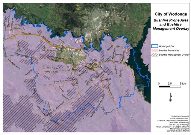
The MFMPC provides a municipal level forum for building and sustaining organisational partnerships
with regards to fire management; and to ensure that plans of individual agencies are linked
effectively so as to complement each other. This is facilitated by the MFMPC having a membership
consisting of representatives from key stakeholder organisations with respect to fire management
within the municipality. Members of the MFMPC are:
•   Wodonga Council (CoW);
•   Country Fire Authority (CFA);
•   Department of Environment, Land, Water and Planning (DELWP);
•   Department of Defence (DoD); and,
•   Parklands Albury Wodonga (PAW).
This MFMP describes how regional authorities, local government, fire agencies and other relevant
organizations can work together to effectively anticipate, respond to and recover from bushfire
events affecting Wodonga. The plan reflects the shared responsibilities of government, fire agencies
and communities and demonstrates a collaborative approach between responsible agencies and
covers both public and private lands.
Fire risks outside the scope of this plan (structure fire – industrial, commercial, health care, public
accommodation and, public assembly and special risks) are addressed in the Municipal Emergency
Management Plan.

1.1    Authority for the plan
The Wodonga FMP has been produced pursuant to Section 20 of the Emergency Management Act
1986 and will be deemed to fulfil Section 55A of the Country Fire Authority Act 1958.

1.2    Period of plan
This plan has been endorsed by the Wodonga MFMPC for a period of three years commencing as of
the date of adoption by Wodonga Council.

1.3    Planning process
This MFMP has been developed in accordance with Part 6A of the Emergency Management Manual of
Victoria.
The municipal fire management planning process is currently under review by EMV. It is anticipated
the review will include substantial changes to the MFMP reporting requirements. In anticipation of
these changes, a full revision of the MFMP was not completed for this version. Instead, this MFMP
was updated from the previous (2012) MFMP to reflect the current fire risk in the municipality; the
risk assessment process employed by the MFMPC (VFRR-B); and an update of the fire management
activities undertaken in the Shire. A total revision of the MFMP is likely to occur once review process
by EMV has be finalised.
The MFMP planning process, illustrated in Figure 2, involves a series of steps that result in the
development, maintenance and continual refinement of plan. Each of the stages guide the planning
process that Wodonga follows, and will continue to do so into the future.
The Wodonga MFMP is not designed to be a duplication of existing plans, rather it aims to
consolidate the significant range of fire related plans that relate to fire.

4
development, maintenance and refinement of an emergency
                    management plan. The diagram at figure 2 illustrates the continuous
                    nature of the planning process and identifies its main steps.

                        Figure 2. Emergency
Figure 2: Emergency management              management
                                  planning process     planning
                                                   (EMV, 2011) process

 January 2011                                   Emergency Management Planning at the Municipal Level
                                                                                           Page 6-3

                                                        Wodonga Municipal Fire Management Plan         5
Stakeholder engagement and participation is an essential element of fire management planning.
Stakeholders are required to participate for a range of reason, including (but not limited to):
• Legislative responsibilities in relation to fire management;
• Leadership;
• Provision of hazard expertise and technical advice;
• Subject to hazard impact – directly and/or indirectly;
• Land tenure and management arrangements;
• Expressed expectation; and,
• Influenced and/or support mitigation.
Stakeholder engagement is required during all seven stages in the EMV planning cycle, the aim being
for them to participate together in the collaborative development, delivery and monitoring of the
MFMP.
Engaging with stakeholders in the development and implementation of the MFMP is an essential tool
for drawing on existing knowledge and experience and to build support for and involvement in this
plan. Table 1 lists the key stakeholders for fire management in Wodonga, and a summary of their fire
management responsibilities.
Table 1: Summary of stakeholder fire management responsibilities in the City of Wodonga.
Agency Responsibilities
CoW Wodonga Council
The council is responsible for providing a strategic and integrated approach to
fire management within the municipality. A key responsibility is the formation
of the Municipal Fire Management Planning Committee and the development of
their Municipal Fire Management Plan.
CFA Country Fire Authority
The Country Fire Authority (CFA) is charged under the CFA Act with the
responsibility for fire safety planning and fire suppression in the Country Area of
Victoria. As part of this responsibility the Act requires that the CFA oversee the
implementation and operation of Municipal Fire Prevention Strategies.
DELWP Department of Environment, Land, Water and Planning
Responsible for the care and management of the majority of public land within
the municipality, including fire prevention and the conservation of native species
and acts in accordance with the Code of Practice for Fire Management on Public
Land.
PV Parks Victoria
Responsible for managing Victoria’s parks network.
6Agency Responsibilities
PAW Parkland Albury Wodonga
Parklands Albury Wodonga is the Committee of Management for large areas
(approximately 2300ha) of Crown Land, much of which is bordering urban
Wodonga. This includes some developed parkland, bushland and agisted grazed
areas.
They are responsible for maintaining the areas under its control in a fire safe
state.
VicRoads VicRoads and its contractors have the direct responsibility for the care and
maintenance of the highways within the municipality. This responsibility
includes fire prevention work.
VicTrack There is one major rail line traversing the municipality. As with the highways this
can be both a control line and a source of ignition.
Electricity Origin Energy is generally responsible for the distribution of electricity within
Distribution the Municipality (66 kV lines and less). The majority of the distribution network
Companies is via overhead power lines. The responsibility for fire prevention is set out in the
Electrical Safety Act 1998.
AusNet AusNet Services is responsible for the distribution of high voltage electricity
Services within the Municipality (220 kV and above). The responsibility for fire prevention
is set out in the Electrical Safety Act 1998.
Envestra Envestra Gas Network
Responsible for the distribution of reticulated gas (515 kPa and less) throughout
the municipality.
AGN Australian Gas Network is responsible for the high-pressure transmission gas
mains that traverse the municipality.
NEW North East Water
The North-East Region Water Authority is responsible for all reticulated water
supplies within the municipality.
GMW Goulburn Murray Water
Responsible for the operation of dams, lakes etc and stock and domestic water
diversion from streams.
NECMA North East Catchment Management Authority
The North East Catchment Management Authority (NECMA) is responsible for
service delivery for waterways (rivers and streams) and floodplain management.
Department of The Department of Defence has significant landholding within the municipality.
Defence Much of this land is covered with native bush whilst other areas contain
extensive buildings and facilities. Defence maintains its own independent and
self-contained fire service for all the land under its control.
Wodonga Municipal Fire Management Plan 7Agency Responsibilities
Commonwealth Commonwealth Department of Finance (formerly Albury Wodonga Corporation)
Department of still own large tracts and parcels of land (and also some smaller allotments
Finance awaiting sale). These are the remains of Albury Wodonga Corporation land,
that was not sold or transferred, prior to the winding up of AWC in 2015. Their
subdivisional layouts and release of certain lands can greatly impact on likely
fire risks into the future. Council staff meet regularly to ensure suitable planning
occurs.
Landcare Wodonga Urban Landcare Network comprises 15 member groups, which include
Friends Groups and Landcare Groups (Baranduda Landcare, Huon Creek Landcare
and Leneva Landcare Groups).
One of the functions of Landcare and Friends Groups is the planting of trees.
It is acknowledged that trees play a vital part in the preservation of a healthy
environment. However, the location and type of trees can also be critical in the
spread of wild fire and the safety of buildings
In the long term it is critical that a good relationship and understanding
is maintained between the Landcare groups, public land managers and
the fire brigades. These community groups can also play role in increasing
community awareness of local bushfire risk and balancing risk mitigation with
environmental restoration objectives.
Local reserves There are 2300 hectares of Crown reserves throughout the municipality, which
Committees of are under the management of Parklands Albury Wodonga as Committees
Management of Management. This committee is responsible for fire prevention on those
reserves. The extent of fire prevention work is undertaken on those reserve
should be determine after consultation with the local CFA brigade.
VICPOL Victoria Police
VICPOL provides a 24-hour police service to the Victorian community. VICPOL
is also responsible for the effective coordination of resources or services in
response to emergencies and for relocation/evacuation; registration of evacuees
in conjunction with the Australian Red Cross; and provision of media co-
ordination.
VIC SES State Emergency Service
Prepares and responds to floods, severe storms, earthquakes, road crash and
rescue and conducts search and rescue operations in bush and Alpine areas.
2.1 Stakeholder analysis
In accordance with the EMV MFMP requirements, the Wodonga MFMPC undertook a stakeholder
analysis and used this as a basis for the development of a Communications and Engagement Plan
concerning the MFMP.
The stakeholder analysis consisted of a two part process; first identifying the key stakeholders who
needed to be engaged in the MFMP’s development and secondly determining the nature and level of
their interest in fire management planning. This second step involved considering each stakeholder
in relation to eight different fire management roles (see Table 2) and four different stakeholder types
(see Table 3).
Once a stakeholder had been categorised, the appropriate level of participation in the process
and the different types of engagement activities required were determined. The results of this
stakeholder analyses is shown in Table 4 and the Communication and Engagement Plan in Table 5.
8These communication and engagement tasks have been built in accordance with the Wodonga
Council Community Engagement Policy (CoW, 2013). It is used as the basis for communication and
engagement planning during the development and subsequent implementation phases.
Table 2: Fire management roles (IFMP, 2010)
Role Description
Bringing together of fire management agencies and elements to ensure
effective response to an incident or emergency. CFA has legislated responsibility
under the CFA Act 1958 for the prevention and suppression of fires and for the
Fire
protection of life and property in the Country Area of Victoria. In accordance
Co-ordination
with provisions in the CFA Act 1958 and the Forest Act 1958, DELWP has fire
management and fire suppression responsibilities for state forests and national,
state and regional parks.
Landholder/managers are heavily involved in fire prevention and fire suppression
on land under their control. They have legislated responsibilities to extinguish
Land Owner/
a fire burning on their land and to prevent fires from starting from the use of
Manager
equipment and vehicles (CFA Act 1958, Crimes Act 1958). They are also required
Responsibilities
to comply with relevant local government laws, relevant planning or building
permit conditions and conditions associated with permits to burn.
Actions taken in anticipation of, during and immediately after a fire incident to
Response
minimise the impact of the fire.
A co-ordinated process of supporting emergency affected communities in the
Recovery reconstruction of physical infrastructure and restoration of emotional, social,
economic and physical wellbeing.
Community education is learning and social development, working with
Community
individuals and groups in their communities using a range of formal and informal
Education
methods
Community Community care is about identifying and catering for groups or individuals with
Care specific needs, before during and after fire.
Asset protection involves protecting key community infrastructure such as
Asset power, water supplies, roads, gas pipes and protecting community assets such
Protection as parks and the environment. Asset protection can also involve the protection
of private assets such as housing, plantations, crops and fences.
The issuing of permits for lighting fires. The development of and compliance
with planning controls and permits for developments and building that take into
Regulatory
account fire risk/management. The regulation and issuing of permits involving
vegetation removal or fuel reduction activities for fire management purposes.
Wodonga Municipal Fire Management Plan 9Table 3: Stakeholder Type and Engagement Level (IFMP, 2010)
Stakeholder Type Description Participation Level
Formal responsibilities for IFMP process
Internal Collaborate
and outcomes
MFMPC membership, responsibility
for development of the plan,
Primary communication and engagement across Collaborate
and within organisations rest with these
organisations
RSFMPC membership or fire
management role within municipality,
may be requested to provide specific
Secondary Involve and Consult
inputs, dependent upon outputs, or
requested to be involved in specific
tasks,
Strong interest in outcomes and may
Tertiary have valuable information/viewpoints to Inform and Consult
share
10Table 4: Stakeholder analysis
City of Wodonga MFMPC Stakeholder Analysis
Type Fire management within Hume region
Fire coordination
RSFMPC member
Community care
Land manager
Asset protect
Stakeholder
information
Community
Secondary
Response
Recovery
Regulate
Tertiary
Internal
Primary
Other
Hume RSFMPC X X
MEMPC X X X
MFMPC X X X
Wodonga Council X X X X X X
Parklands Albury/Wodonga X X
Dept of Defence X
CFA X X X X X
DELWP X X
Parks Victoria X X X
DHHS X
Vic Pol X X X X X
SES X X X X
Vic Roads X X X
AusNet Services X
VLine X X
NE water X X X X X
GMW X X X X
Telstra X X X X
Optus X X X X
NECMA/GBCMA X X X X X
HVP X
DET X
Ambulance Vic X X X X X
Media X X X X
Local community/industry groups X X X
AlburyCity Council X X X
Wodonga Municipal Fire Management Plan 11Table 5: City of Wodonga MFMPC Communication and Engagement Plan.
Wodonga Council MFMPC Communication and Engagement Plan
Engagement Activity
Draft consultation
reports & agendas
Meeting minutes,
Special meetings
Wodonga Council
1:1 consultation
Media articles
Email updates
Individual org
3 year review
Engagement
Stakeholder
Level
networks
website
Internal Stakeholders
Hume RSFMPC
MEMPC Collaborate X X X X X X
MFMPC
Primary – answerable for activity/decision
Wodonga Council
CFA
DELWP Collaborate X X X X X X X
Parklands Albury Wodonga
Dept. of Defence
Secondary – Contributory responsibility
Parks Victoria
DHHS
DPCD
DPI
Vic Pol
SES Involve and
consult
X X X X X X X
Vic Roads
AusNet Services
VLine
GMW
Relevant water authority
Telstra
Tertiary - Interested
Optus
NECMA/GBCMA
HVP X X X X X X X
DET Inform and
Ambulance Vic consult
Media X X X
Local community/industry groups X X
General public X X X X
12Environmental scanning involves identifying key themes, issues, trends and gaps that may affect or
influence fire management. It establishes the base level of knowledge and understanding required
for supporting risk identification, risk assessment and risk treatment within a fire management
context. Furthermore, it provides the basis for identifying fire management objectives and decision
making with regard to selecting strategies to achieve these objectives.
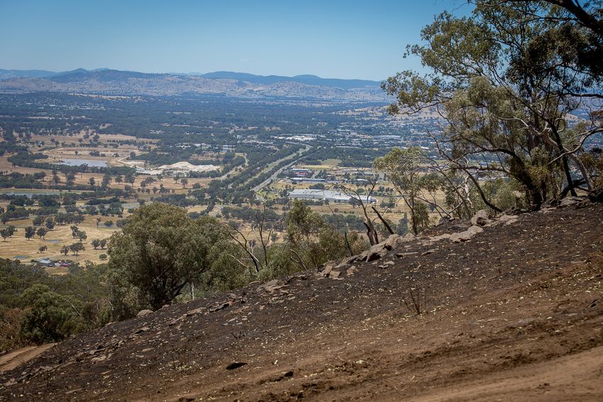
Figure 3: Wodonga Council municipality
3.1 Municipal Profile
Wodonga is located approximately 300 kilometres north-east of Melbourne, on the southern side of
the Murray River. The municipality covers an area of 430 square kilometres. Wodonga is the main
city within the municipality and is also the largest city in North East Victoria.
The community of Albury-Wodonga encompasses about 80,000 persons and with Albury being a
large regional city on the boundary, an agreement (MOU) was signed on August 15, 2016 to ensure
resources and equipment could be shared between either as necessary. A similar MOU is in place
with all Victorian councils.
3.1.1 Land tenure
More than 70 per cent of the land within the municipality is private land. Outside the main urban
area, the predominant land use is agriculture. There are also large areas of bushland reserves,
managed by the council, DELWP, Parks Victoria and Committee of Management. The municipality also
contains two large military areas, one at Bandiana and Bonegilla.
Wodonga Municipal Fire Management Plan 13per cent total land
Land Manager Hectares
in Wodonga LGA
Committee of Management - CoW 86.7 0.2 per cent
Committee of Management - Local 1.9 0.0 per cent
Committee of Management - OTHER 1676.7 3.9 per cent
Commonwealth – Dept. of Defence 747.0 1.7 per cent
DELWP 475.7 1.1 per cent
Parks Victoria 3952.7 9.1 per cent
Other Gov Dept* 10.6 0.0 per cent
Water Authority 18.4 0.0 per cent
Statutory Authority 1261.9 2.9 per cent
*Includes Department of Justice and Regulation, Department of Economic Development, Jobs Transport, and Resources (DEDJTR) (transport),
Department of Health and Human Services (DHHS), Department of Education and Training (DET).
#Includes utilities, water production, and transport.
3.1.2 Population and Demographics
The population of the municipality at the 2016 Census was 39,351 (ABS, 2017), of which the majority
live within the Wodonga urban area. Other smaller centres include Leneva, Killara Village, Ebden
Village, Baranduda Development Area, Valley Views Estate and Patrice Vale Estate, as well as the two
military sites at Bandiana and Bonegilla. The municipality has an average growth rate of 2 per cent
per cent per year (id Consulting, 2017), with the population expected to reach 54,728 by 2031 (CoW
and Walker Geospatial and Data Analysis, 2015).
The breakdown of the population of Wodonga LGA by age is shown in Figure 4.
Figure 4: Age groups of the Wodonga population, 2016 Census (ABS, 2017).
Elderly aged (85 and over) 745
Seniors (70 to 84) 3,142
Empty nesters and retirees (60 to 69) 4,235
Older workers and pre-retirees (50 to 59) 4,932
Parents and homebuilders (35 to 49) 7,392
Young workforce (25 to 34) 5,417
Tertiary education and independence (18 to 24) 3,806
Secondary schoolers (12 to 17) 3,061
Primary schoolers (5 to 11) 3,798
Babies and pre-schoolers (0 to 4) 2,828
0 1,000 2,000 3,000 4,000 5,000 6,000 7,000 8,000
14The vast majority of people in the Wodonga LGA were born in Australia (32,683 people, 83.1 per cent),
with 1.8 per cent (705 people) born in England, 0.8 per cent (313 people) born in New Zealand, 0.7
per cent (294 people) in India, and 0.7 per cent (291 people) in Germany. 975 people stated they are
Aboriginal and/or Torres Strait Islander. 87.6 per cent (34,578 people) stated they speak English only
at home. Other languages spoken include Indo-Aryan languages (Bengali, Hindi, Punjabi, Sinhalese,
Urdu, other), Chinese languages (Cantonese, Mandarin, other), Southeast Asian Austronesian
languages (Filipino, Indonesian, Tagolog, other), German, Croatian and Italian.
Within the Wodonga municipal there are several groups who may be more vulnerable to impacts of
bushfire (including smoke). These include the following.
• Lower socio-economic groups
• Senior Citizens and residential care facilities. 15 per cent of the population is 65 and over. There
are five residential aged cared facilities, four supported residential service facilities, and a
number older person independent living complexes and retirement villages within Wodonga.
• Hospitals. There is one public (AWH Wodonga Campus) and one private (Murray Valley Private)
hospital in Wodonga.
• Children and young people. There are more than 8100 children under the age of 15 in Wodonga.
There are 20 primary and secondary schools, both public and private, a special development
school; the Wodonga Institute of TAFE; and a regional campus for La Trobe University.
• Special assistance. In the 2016 Census, 2298 people identified as needing assistance in
their day to day lives with any or all of the following activities; self-care, body movements or
communication.
3.1.3 Land Use, Economy and Infrastructure
Wodonga is home to approximately 2700 businesses, with the top five industry sectors being public
administration and safety; manufacturing; rental, hiring and real estate services; health care and
social assistance; and education and training (CoW, 2017). The two military areas and the Logic
Centre provide a significant contribution to the local economy. Cross-border economic links are
strong with a large number of people commuting into and out of the municipality to work. Outside
the urban area the land use is predominantly mixed farming such as dairying, wool production and
cattle. The gross regional product of Wodonga is estimated to be $2.68 billion annually, with an
annual growth rate of 1.7 per cent in the 2015-2016 financial year.
The median weekly wage for a household in Wodonga was $1075.00 (2011 Census) and the average
unemployment rate in 2016 was 6.2 per cent in 2016 (CoW, 2017). Wodonga has a score of 963 on
the Relative Socio-economic Index of Advantage and Disadvantage 2011, meaning the level is just
below (more disadvantaged) the national average.
The municipality is well serviced by roads with two crossings of the Murray River. The Hume Freeway,
Murray Valley Highway, Kiewa Valley Highway and main Melbourne-Sydney rail link traverse the
municipality.
3.1.4 Natural Environment
The city supports a variety of geologies, soil types and landscape settings and this natural variability
gives rise to a diverse range of vegetation types and habitats. The topography varies from river flats
to steep hill country.
The western quarter of the municipality contains some steep terrain and a number of valleys
terminating in steep slopes into the Indigo valley. The Baranduda range and Patrice Vale lie at the
southern boundary of the municipality with Indigo Shire. Most of this area is forest reserve and
contains some steep slopes. This range terminates at the Baranduda Range subdivision from where
the land slopes gently down to the Kiewa River. The Kiewa and Murray rivers (including Lake Hume)
Wodonga Municipal Fire Management Plan 15provide major physical barriers across and along the boundary of the municipality. The city straddles two bioregions - Victorian Riverina and Northern Inland Slopes – both of which are considered moderately to highly cleared. Dominant vegetation types within the area include box-gum grassy woodland, wet sclerophyll forest and river red-gum woodland and forest. More specifically, there are 19 different Ecological Vegetation Classes (EVCs) within the city (see Figure 5). The conservation status of most of the EVCs is either endangered or vulnerable. Figure 5: City of Wodonga Ecological Vegetation Classes Much of the vegetation that remains may also meet the definition of the threatened vegetation community ‘White Box – Yellow Box – Blakely’s Red Gum Grassy Woodland and Derived Native Grassland’, listed under the Commonwealth’s Environment Protection and Biodiversity Conservation Act 1999. Unique to the region are the extensive areas of tree plantings. A program known as Forward Tree Planting was undertaken by the erstwhile Albury Wodonga Development Corporation (AWDC) and sought to improve environmental values in response to increasing urbanisation, establishing more than three million trees on more than 2000 hectares of land across Albury and Wodonga between 1976 and 1996. Over time these plantings have been found to provide habitat and landscape linkages for many species including woodland birds and threatened species such as the Regent Honeyeater and Squirrel Glider. Nineteen terrestrial fauna species and four flora species listed under the Flora and Fauna Guarantee Act 1988 have been recorded within Wodonga. Five of these are also listed under the EPBC Act, including several considered critically endangered. There is a relatively large network of reserves in the municipality that are managed for environmental outcomes. The 98 separate reserves that make up this ‘environmental estate’ can be divided into 16
four categories.

•   Wodonga Retained Environmental Network (WREN) – land subject to a Native Vegetation Precinct
    Plan throughout the Leneva and Baranduda. Total reserve is approx. 700ha.

•   Hilltop Reserves - Huon, Maher’s, Hunchback, and Federation Hill. These reserves are located
    around the outskirts of the Wodonga urban area and total approx. 2300ha.

•   Vegetation offsite sites - several are within larger hilltop reserves and some are separate
    reserves within White Box Rise, Alpine Views and Silky Oaks residential estates, and at the
    Logic industrial hub. Total area approx. 260ha.

•   Crown reserves managed by Parklands Albury Wodonga (PAW), including hilltop and WREN reserves
    and Murray and Kiewa river frontage totalling approx. 2000ha.

3.1.5 Cultural heritage
There are a number of significant cultural heritage sites within Wodonga. This includes the Bonegilla
Migrant Experience, Bandiana Army Museum and a number of Aboriginal cultural sites. In terms of
Aboriginal cultural heritage, there is no Representative Aboriginal Party (RAP) in place for the area
and no RAP applicant exists; however, there are three interested parties: including the Dhudhuroa
Waywurru Nations Aboriginal Corporation, Duduroa Local Custodians Incorporated, and Yaitmathang
Indigenous Lands Council. Places of Aboriginal cultural heritage are frequently detected across
the municipality and unidentified places are likely to exist. Cultural heritage sensitivity mapping
indicates the areas most likely to contain Aboriginal places of significance.

3.1.6 Climate
Wodonga is in the temperate zone, which is characterised by having four seasons - summer, autumn,
winter and spring. The average maximum temperatures for January and February are in the low 30s.
Individual days here may be very hot, the highest temperatures on record generally being in the mid-
40s. Annual rainfall is variable with the long term average being about 700mm, and the majority of
rain falling in the winter and spring months.

Elevated fire weather in the Wodonga region is more likely during summer (December to February),
although may also occur in late spring or early autumn.

Climate change projections for the North East (DSE, 2008) show an increase in average annual
temperatures and a reduction in rainfall. Conditions will become drier, with increased potential
evaporation and reduced relative humidity. The impact of these changes is expected to be an
increase in bushfire risk, due to the combination of an increased number of elevated bushfire
weather days and an increased fuel availability (due to fuel moisture loss). Climate predictions are
that by 2030 the average annual temperature will be about 0.9 degrees warmer, and the number of
days over 30 degrees to increase. There is little change in expected average wind speeds.

3.1.7 Fire weather
In South-eastern Australia, the McArthur (Mark 5) Forest Fire Danger Index (FFDI) and the CSIRO
Grassland Fire Danger Index (GFDI) are typically used to represent both the level of bushfire threat
and difficulty of suppression on a given day, based on a set of fuel and weather conditions. They are
critical inputs in determining key fire behaviour parameters such as forward rate of spread, fireline
intensity, flame length and spotting distance. The bushfire season is generally considered to have
begun when high or very high fire dangers are forecast on consecutive days and extends through the
summer months (Long, 2005).

The FFDI and GFDI are also important inputs in treatment planning, and the conditions under
which fire management controls are expected to be effective. The choice of weather conditions
determines both the potential severity of a bushfire event and the return interval (likelihood) of
those weather conditions occurring. The higher the FFDI/GFDI, the less likely those conditions are

                                                          Wodonga Municipal Fire Management Plan       17
to occur; however, if they were to occur, the more severe a bushfire would be on that day (all other
things being equal).
The Fire Danger Rating (FDR) is forecast for four days in advance for districts across the state. Hume
is within the Central District. The FDRs range from Low-Moderate to Code Red, and area based on the
forecast maximum FFDI or GFDI for that general geographic area. A Total Fire Ban (TFB) is declared for
a district when fires are likely to spread rapidly and be out of control (generally at an FDR of Severe or
above). Refer to Table 7 for an explanation of the FDRs and the corresponding index ranges and fire
behaviour.
Table 7: Fire Danger Ratings (AFAC, 2012; CFA, 2016)
Total Fire
FFDI Range GFDI Range FDR Potential Fire Behaviour
Ban
These are the worst
conditions for a bush or
grass fire.
Homes are not constructed
100+ 150+ Code Red Yes to withstand fires in these
conditions.
The safest place to be is
away from high risk bushfire
areas.
Expect extremely hot, dry
and windy conditions.
If a fire starts and takes
75-99 100-149 Extreme Yes hold it will be uncontrollable,
unpredictable and fast
moving. Spot fires will start,
move quickly and come from
many directions.
Expect hot, dry and possibly
windy conditions.
50-74 50-99 Severe Yes If a fire starts and
takes hold, it may be
uncontrollable.
May be
declared
If a fire starts, it can most
25-49 25-49 Very High a TFB at
likely be controlled in these
discretion of
conditions and homes can
CFA
provide safety.
12-24 12-24 High No Controlled burning may occur
in these conditions if safe.
0-11 0-11 Low – Moderate No
18The appropriate weather inputs for treatment planning may vary depending on the scenario for which
the treatment is to apply. For example, the width of a firebreak may be determined using a lower
FFDI than the location and size of APZs, due to it being unlikely a firebreak is effective in extreme fire
weather conditions.
An analysis of the Albury Automatic Weather Station (AWS) data was performed to understand the
occurrence of elevated fire weather days in Wodonga (Terramatrix, 2016).
Table 8: Modelled FFDI’s at various return intervals (Terramatrix, 2016).
FFDI Recurrence
12 0.2
25 0.3
50 1.3
75 5.0
100 19.0
120 55.0
Table 9: Modelled GFDI’s at various return intervals (Terramatrix, 2016)
GFDI Recurrence
12 0.7
25 1.0
50 2.1
75 4.3
100 8.9
130 21.0
Climate change projections for the Hume region shows an increase in average annual temperatures
and a reduction in rainfall. Conditions will become drier, with increased potential evaporation and
reduced relative humidity. Climate predictions are that by 2030 the average annual temperature will
be about 0.6 degrees to 1.3 degrees above the climate of 1968-2005. By 2070, the projected range
of warming is 1.2 to 3.3 degrees, depending on the emissions scenario. The temperature reached on
hot days is likely to substantially increase, as are the number of hots days (greater than 35 degrees)
and hot spells anticipated to last longer. There is little change in expected average wind speeds.
The impact of these changes is expected to be an increase in bushfire risk, due to the combination of
an increased number of elevated bushfire weather days and an increased fuel availability (due to fuel
moisture loss). Climate change projects indicate that Victoria is likely to have up to 70 per cent more
Severe, Extreme and Code Red days by 2050 (DELWP, 2015c).
Wodonga Municipal Fire Management Plan 193.1.8 Fire History The municipality has an annual fire season and averages 48 bushfires per year (see figure 13) with the main sources of ignition being classed as either “suspicious” or “unknown” (see fig 12, CFA FIRS). The fire history for Wodonga is shown as listed in the Wodonga Municipal Emergency Management Plan 2018 part 4.3 History of emergencies Date Fire – threat from Eldorado February 2003 Fire February 2006 Fire – threat from Baranduda February 2009 Fire – BUPA nursing home smoke in air conditioning system July 2009 Fire – Klings Hill - Plunkett Road and surrounds December 2014 Fire- Barnawartha/Indigo Valley Creek December 2015 The Wodonga area has on average five bushfires per year with the main source of ignition being “misuse of heat” ignition (FIRS Fire history 10/11). Figure 6: Bushfires in the Wodonga municipality 1940 - 2017 (DELWP, 2018). 20
The Municipal Fire Management Objective provides a framework for considering, selecting and
evaluating fire management activities. This objective was developed using the information examined
during the environmental scanning process, as well as being informed by the Hume Regional Fire
Management Plan and relevant issues and priorities from regional stakeholders and adjoining
municipalities.

4.1 Municipal Objective
The Wodonga municipality working together to effectively anticipate, respond to and recover from
significant fire – to secure a safer municipality, more resilient community, healthier environment
and a prosperous economy.

4.2 Strategic Direction
In developing strategic directions for this plan the MFMPC was mindful of the planning context
within which they were undertaking this task. As illustrated in Figure 1, the MFMP forms a critical
component in Victoria’s Fire Management Planning hierarchy and therefore must not be developed in
isolation from state and regional level fire management plans.

The State Fire Management Strategy 2014 states that “the objective of all bushfire management
activities in Victoria is to reduce the impact and consequences of bushfire on human life,
communities, essential and community infrastructure, the economy and the environment”. The
Ssate strategy identifies the following principles to guide bushfire management activities.

•   Leadership

•   Protection of human life

•   Responsibility for building resilience

•   Community involvement

•   A seamless approach

•   Risk driven

•   Learning and knowledge

4.3 Alignment of Regional and Municipal Objective
The Wodonga municipal fire management
objective aligns closely with the Hume RSFMP
objectives and vision for fire management.
The development and implementation of this        Hume Regional Fire Management Vision
plan will therefore contribute significantly to
                                                  The Hume Region working together to
the realisation of the Hume Regional Strategic
                                                  effectively anticipate, respond to and recover
Fire Management Plan’s vision. The MFMP
                                                  from major bushfire – to secure a safer
contribution to the RSFMP is summarised in
                                                  region, more resilient community, healthier
figure 7.
                                                  environment and a prosperous economy.

                                                        Wodonga Municipal Fire Management Plan     21
You can also read