GIPPSLAND REGIONAL COASTAL PLAN 2015-2020 - Marine and coasts
←
→
Page content transcription
If your browser does not render page correctly, please read the page content below
GIPPSLAND REGIONAL
COA S TA L P L A N 2015–2020
Gippsland Coastal Board                         Authorised and published by the Victorian
71 Hotham Street, Traralgon VIC 3844            Government, Department of Environment,
Phone: (03) 5172 2543                           Land, Water and Planning, 8 Nicholson
                                                Street, East Melbourne, September 2015
Electronic copies of the plan are available
online at www.gcb.vic.gov.au.                   © The State of Victoria Department of
If you would like printed copies or have any    Environment, Land, Water and Planning
questions about the plan, please contact us     Melbourne 2015
using the details above.
Members of the Gippsland Coastal Board at
the time of preparing this Regional Coastal
Plan were:                                      This work is licensed under a Creative
                                                Commons Attribution 3.0 Australia licence.
Cr Richard Ellis (Chair)
                                                You are free to re-use the work under that
Mr Ian Needham
                                                licence, on the condition that you credit the
Mr Peter Jennings
                                                State of Victoria as author. The licence does
Mr Paul Smith
                                                not apply to any images, photographs or
Mr Michael (Des) Sinnott OAM
                                                branding, including the Victorian Coat of
Mr Rod Thomas
                                                Arms and the Victorian Government logo.
The Gippsland Coastal Board proudly             To view a copy of this licence, visit http://
acknowledges Victorian Aboriginal               creativecommons.org/licenses/by/3.0/au/
communities and their rich culture; and pays    deed.en
its respects to the Traditional Owners in the
                                                ISBN 978-1-74146-784-0 (Print)
Gippsland Coastal Region. The Board also
                                                ISBN 978-1-74146-785-7 (pdf )
recognises the intrinsic connection of
Traditional Owners to Country and               Disclaimer
acknowledges their contribution in the
                                                This publication may be of assistance to you
management of land, water and resources
                                                but the State of Victoria and its employees
management.
                                                do not guarantee that the publication is
                                                without flaw of any kind or is wholly
                                                appropriate for your particular purposes and
                                                therefore disclaims all liability for any error,
                                                loss or other consequence which may arise
                                                from you relying on any information in this
                                                publication.
                                                Unless stated, images sourced from the
                                                Department of Environment, Land, Water
                                                and Planning.

Front Cover Top: Cape Conran rocks. Bottom
from left: Lakes Entrance. Sailboats at Lakes
Entrance. Fishermans Landing, Lake Tyers.
Photos: Destination Gippsland.
Bottom right: Lakes Entrance, Victoria.
c1920-1954 Photo: Rose Stereograph Co.
GIPPSLAND REGIONAL
                                                                                                                                   COA STA L PLA N
                                                                                                                                                                    I

CONTENTS
Minister’s Foreword                                           II   Balanced Decision Making                          18   List of Figures
Chair’s Foreword                                              II   4	Managing regional population and tourism            Figure 1: The three levels of
1   Introduction                                              1       pressures                                      18   planning for coastal management      1

    1.1   The role of the Gippsland Coastal Board              1       4.1   Background                              18   Figure 2: The Gippsland coastal
                                                                       4.2	The Boating Coastal Action Plan          19   region                               3
    1.2   What is the Regional Coastal Plan?                   1
                                                                       4.3   Activity and recreation nodes           20   Figure 3: Indicative map of the
    1.3   How the Regional Coastal Plan will be used           4                                                          key regional social, economic and
    1.4   Who we work with on land and water                   4       4.4   Key challenges and actions              21   environmental values of the
                                                                   5   A regional approach to foreshore management   22   Gippsland coastal region             8
    1.5   Priority actions for the Gippsland coastal region    5
                                                                       5.1	Background                               22   Figure 4: Managing visitor
Valuing and Understanding the Coast                           7
                                                                                                                          satisfaction with their coastal
2   Coastal values                                            7        5.2   Integrated coastal management           24
                                                                                                                          experience – key amenity values     10
    2.1   Environmental values                                 7       5.3   Key challenges and actions              25
                                                                                                                          Figure 5: Community coastal
    2.2   Social values                                        9   6	Adapting to climate change and increased            values guide decisions in the
                                                                      coastal hazards                                26   Gippsland coastal region            13
    2.3   Economic values                                     11
                                                                       6.1   Background                              26   Figure 6: Indicative map of current
    2.4   Protecting coastal values                           12                                                          boating hierarchy of facilities from
                                                                       6.2	Adaptation planning to manage flooding
3   The dynamics of the coast                                 14            and erosion                              26   the Gippsland Boating Coastal
                                                                                                                          Action Plan 2013                     19
    3.1   Coastal processes                                   14       6.3   Key challenges and actions              29
                                                                                                                          Figure 7: Indicative map of
    3.2   Climate change                                      14   Implementation                                    30   foreshore and waterway managers 23
    3.3   Connections to catchments                           16   7   Supporting communities caring for the coast   30   Figure 8: Map indicating areas for
    3.4   Demographic trends                                  16       7.1   Background                              30   hazard assessment and adaptation
    3.5   Visitation trends                                   16                                                          planning (based on coastal
                                                                       7.2   Actions                                 31
                                                                                                                          instability and low lying areas)   28
    3.6   Industrial processes                                17   8   Monitoring, Evaluation and Reporting          32
                                                                                                                          List of Tables
                                                                   9   References                                    34
                                                                                                                          Table 1: Gippsland region priorities
                                                                   Appendices                                        35   for actions                          5

Cowrie Bay
Photo: Destination
Gippsland
II         GIPPSLAND REGIONAL
           COA S TA L P L A N

MINISTER’S FOREWORD                                                                     CHAIR’S FOREWORD
The coast is close to the hearts of the      This Plan will support government          Gippsland is a uniquely spectacular part     organisations that gave feedback about
many Victorians who live near it, or visit   agencies, community and industry           of Victoria, with its unspoilt wilderness,   the draft plan. These actions will help
it, and enjoy all that it has to offer.      groups to work more collaboratively in     pristine beaches and rich array of           to:
Communities along the coastline are          managing the coast. It will help coastal   wildlife on land and underwater.             –	make sure the coast continues to be
deeply connected to their local              managers and communities tackle            Alongside our coast’s pure white sandy          the place we love, while planning
landscape and care about the future of       challenges on the coast in their region    beaches, headlands and peaks are the            for more people wanting to visit and
the coast.                                   more effectively, and with greater         significant oil, gas and coal resources         settle here;
Our coastal environment is complex           coordination. It will enable us to be      that supply much of Australia’s energy.
                                             more responsive and adaptable as                                                        –	improve the way communities plan
and constantly changing, and there are                                                  For Gippsland’s residents, our coast is a       for coastal flooding so that it makes
many pressures that need to be               pressures change over time, and our
                                             understanding of climate change            source of well-being and relaxation, an         sense to them but doesn’t leave
understood and managed better. As                                                       attractive expanse to enjoy with family         future generations with a debt they
Minister and a Local Member of a             implications improves.
                                                                                        and friends.                                    can’t pay;
coastal area, I appreciate how               The local knowledge, passion and
important it is to understand, protect       enthusiasm of Victoria’s coastal           Whether it’s on a boat exploring the         –	simplify foreshore management and
and care for the things we love about        managers and communities is                Lakes network of waterways, camping             make more out of the available
the coast.                                   invaluable, and I look forward to          down the Prom or Cape Conran, surfing           resources and our joint efforts; and
                                             working together to ensure that the        on the Bass Coast or walking along the       –	continue to support and encourage
Victoria has a strong coastal planning                                                  Ninety Mile Beach, we recognise that
and management framework, based on           diverse natural, social, cultural and                                                      more community involvement in
                                             economic values of the coast that we       Gippsland is a paradise for all.                protecting those coastal values we
the Victorian Coastal Strategy (2014).
The Gippsland Coastal Board has              enjoy today remain for future              This plan acknowledges all the good             love.
developed this Regional Coastal Plan to      generations.                               work going on to identify, understand        I would like to thank the Board for their
build on that framework and outline                                                     and protect the local, regional and          work in developing the Plan. As well, I
how the Strategy should be put into                                                     statewide values of the coast and to         want to thank everyone who
                                             The Hon Lisa Neville MP                    support that work on the big issues at a
practice.                                    Minister for Environment, Climate                                                       contributed to the Plan by coming to
                                                                                        regional level.                              meetings, writing a submission and
                                             Change and Water
                                                                                        The actions outlined in this Plan are        discussing these important issues.
                                                                                        aimed at addressing the regional             These efforts mean the Plan will make a
                                                                                        priorities identified by the Board with      difference to the way we look after our
                                                                                        the help of the many people and              coast over the next five years.

                                                                                                                                     Councillor Richard A Ellis
                                                                                                                                     Chair, Gippsland Coastal Board

                                                                                                                                                          Metung
                                                                                                                                                          Photo: Roberto Seba,
                                                                                                                                                          Tourism Victoria
GIPPSLAND REGIONAL
COA STA L PLA N
1
1 INTRODUCTION
1.1 The role of the
Gippsland Coastal Victorian Coastal Developed by the Sets statewide direction
for coastal planners
Board Strategy
Victorian Coastal
Council and managers
The Gippsland Lakes and Coast Regional
Coastal Board (commonly known as the
Gippsland Coastal Board) is a statutory
planning and advisory body with
extensive experience and expertise in
coastal matters. The Board provides Developed by Translates state-wide
strategic guidance for coastal Regional Regional Coastal direction by identifying
Coastal Plans Boards regional values, initiatives
management of Victoria’s Gippsland and management gaps
coast. It has specific functions under
the Coastal Management Act 1995.
These are to:
– Develop coastal action plans
Clinton Rocks,
(including this overarching Regional Developed by coastal
Croajingolong National Coastal Sets local direction and
Coastal Plan); Park, East Gippsland. 1.2 What is the Regional Management
public land managers
(eg. local municipalities develops sub-regional or issues
based operational plans
– Provide advice to the Minister, the Coastal Plan? Plans & committees of
management)
Victorian Coastal Council and
– Liaise with, and encourage the The Regional Coastal Plan for the
government on coastal development
cooperation of, government Gippsland coastal region is a statutory
and other matters in the region;
departments, councils, public Coastal Action Plan endorsed under Figure 1: The three levels of planning for coastal management
– Prepare and publish guidelines for authorities, industry, community Part 3 of the Coastal Management Act
coastal planning and management groups and those involved in the 1995. Its contents meet the requirements
in the region; planning and management of the of section 23 of that Act.
– Facilitate the implementation of the region in developing and
The Victorian Coastal Strategy 2014 sets The Victorian Coastal Strategy 2014 identifies that the term ‘coast’ means:
Victorian Coastal Strategy, coastal implementing strategic solutions to
matters affecting the conservation the broad framework for managing the – The marine environment – nearshore marine environment, the seabed,
action plans and coastal guidelines coast and the basis for developing
for the region; and use of the region’s coast. and waters out to the State limit of three nautical miles
regional coastal plans and coastal
– Facilitate public awareness, More broadly, the Board seeks to be an management plans (Figure 1). The – Foreshores – or coastal Crown land up to 200 m from the high water mark
consultation and involvement in the advocate for coastal issues. It aims to Gippsland Coastal Board has focussed – Coastal hinterland – land directly influenced by the sea or directly
development and implementation work with agencies, local councils and this overarching Plan on identifying and influencing the coastline, and with critical impacts on the foreshore and
of the Victorian Coastal Strategy, communities in the Gippsland coastal prioritising those management actions nearshore environment
coastal action plans and coastal region to shape future expectations that cannot be achieved more effectively
about how the coast and use of the – Catchments – rivers and drainage systems that affect the coastal zone,
guidelines in the region; and at either the local or state level.
coast will change over time, how we including estuaries and coastal wetlands
should respond to those changes, and The Regional Coastal Plan provides a
– Atmosphere – near, around and over the coast as defined above.
how we should use and manage the regional framework for planning and
coast to protect its values. decision-making on both public and2 GIPPSLAND REGIONAL
COA S TA L P L A N
freehold land at the local level. It also The principle of ‘Integrated Coastal Zone
provides a focus for all agencies with Management’ (ICZM) underpins the
responsibility for coastal management Gippsland Regional Coastal Plan. ICZM
to act together to plan and manage the is about working across a geographic
coast by: area (land to sea), across different land
– Interpreting and implementing the tenures (public and private), and across
Victorian Coastal Strategy 2014 and organisations and jurisdictions
its hierarchy of principles at a (national, State, regional and local).
regional scale; ICZM is achieved through both formal
and informal collaboration and
– Facilitating integration across coordination between the various
jurisdictions to increase efficiency groups using and managing the coast.
and effectiveness;
This plan has three parts:
– Identifying regional coastal values
and strategic priorities to be – Chapters 2 and 3 give an overview
accounted for; and of the values of the Gippsland
coastal region and the key issues
– Identifying solutions that address affecting them;
systemic gaps in coastal management. Tidal River, Wilsons
Promontory As a statutory document, the Regional – Chapters 4, 5, 6 and 7 set out the
The Plan will provide the framework for Photo: Peter Jennings strategic objectives for the region
Coastal Plan has important links with
agencies, community and industry (as regional priorities); and
other statutory instruments. In
groups working and engaging with
particular, as outlined in the Victorian – Chapters 7 and 8 explain how the
decision makers on emerging strategic
Coastal Strategy 2014, the broader land Board intends to work with its partner
regional priorities for the Gippsland
use planning system is important for agencies and other stakeholders,
coastal region. The Plan will also guide
the implementation of the Strategy, and summarises how the plan will
the development of coastal
Regional Coastal Plans and coastal be implemented, including the
management plans.
management plans (see Appendix 1). process of monitoring and reporting.
The Plan’s primary audiences are local The relationship between these policies
councils, committees of management, and plans is through:
state government agencies and peak
– The State Planning Policy Framework
bodies with coastal management
which requires coastal planning to
responsibilities. It also aims to provide Sea urchin be consistent with the Strategy and
landowners, volunteer groups and
relevant coastal action plans
coastal communities with an
(including the Regional Coastal Plan)
understanding of the framework for
and regional growth plans; and
managing and protecting coastal
Pelicans at Metung – Sections of local planning schemes
values in the region and how they can Photo: Destination
contribute to that. Gippsland through Municipal Strategic
Statements and Local Planning
Policy Frameworks.GIPPSLAND REGIONAL
COA STA L PLA N
3
O
ray
Riv
er
Hierarchy of Principles
me
r
oH
Mu
i ve
r
The Victorian Coastal Strategy 2014
wy
R
supports the hierarchy of principles
wy
N
Sno
R i ve r
Falls Creek
introduced in previous Strategies and
M itta
Lake
also recognises that the foundation
tta
Omeo
er
Mi
Riv
of coastal planning and management
ate
leg
EAST GIPPSLAND is a healthy coastal and marine
De
Cobungra Omeo
Wa n n a n Catchment Management Authority
g at
ta environment. These principles give
o n a r o H wy
Riv
r
effect to the directions in the Coastal
u ch a n R i v e
er
Litt l e R i v e r
ipy Rd
0 20 40 Bonang
Swifts
Creek
B
Management Act 1995 and are
M
Gelant
kilometers Gr
included in the State Planning Policy
r
EAST GIPPSLAND
a R i ve
y
ea
Hw
s
tA
Framework and in planning
Ca ledoni
lpine Rd
e
Rd
nc
Pri
Ge
ang
Dargo
schemes throughout Victoria.
no
aR
B on
i ve
r
Mallacoota
The principles are:
Nic
Ta m b
Snow
Boggy
Inlet
hol
B ro d r
Riv r Lake
Ma
son
o
yR
Darg e Cann River Barracoota
cal
Licola
– Ensure the protection of
iver
Cre e k
Riv
is te
i b b R i ve r
WELLINGTON oR
Gabo Island
er
r R i ve r
Wi n g a
Bemm
d Mallacoota significant environmental and
Can n R i v e r
T h u r a R i ve r
Bruthen
L i c o l a Rd
Orbost
n R i ve r
cultural values;
Rive
Nowa Nowa
r
Mitchel l R Lake Lake
i ve r Curlip
r
Pe r Corringle Swan
ry Bairnsdale Lake
– Undertake integrated planning
Avo
I I I I I I Wingan
R iv
y I
n Rive
I
WEST GIPPSLAND w I I
Lake I I Sydenham Tamboon
ces H Cap
I I
Ewing Marsh Marlo Inlet
er
e Conran
I
Glenmaggie I
Prin Lake
and provide clear direction for the
I
I I
I Lake Inlet Inlet
Catchment Management Authority I
I King Lakes Tyres
r
I
Maffra I
I
Paynesville Entrance
future; and
I
I
Heyfield I
I
Stratford Lake
Thom Gippland Lakes
I I I I I I
Victoria
BAW BAW
s on Coastal Park
Princes Fwy R Meerlieu
Clydebank
– Ensure the sustainable use of
i ve
I I Morass
I I I I I
Lake Loch Sport
r
I I I
I
Sale
I I I I
natural coastal resources.
I I I I I
Wellington
I
I I I
I I I Warragul I
I
L a Tr o b e R i v e
I I I
Moe Traralgon I
I
r Lake h
ac
I
Drouin
I I I
I I I
I I I
I
Reeve
I I
The Heart
Be
I I I I I
I I I Rosedale
Only when the above principles have
I I I I
Lake
I
I I Morass
an g L a n g R i v e r
I I
I I I
Morwell I I I
I
I
I
I I
I I
rri ma n C r e e Coleman Paradise Beach
Me k
L
I I
y
I
Trafalgar
been considered and addressed:
d Hw
Golden Beach
Churchhill SETTLEMENT ROLE AND GROWTH
n
e
psla
il
R i ve
r
Mirboo North M – Ensure development on the coast
Gip
ass Korumburra
LATROBE Regional city (Latrobe City)
Brut h e n C re e
B
is located within existing modified
uth
Seaspray
Ta r Jack Smith
So
ra R
Leongatha i ve Lake
ty Sub regional network and resilient environments where
ne
SOUTH GIPPSLAND
Alb
er t
k
r
Woodside
the demand for development is
Ni
Riv
er Regional centre
A gne
tt Rive r
Po w l e Yarram
evident and any impacts can be
s R iv
Inverloch
Waterbody Town
iver
Foster
managed sustainably.
er
Toora
nR
Venus
Port
Tar
wi
Bay Port
Parks & Reserves Small town
Waratah
Welshpool Albert
The actions in this Regional Coastal
Bay
Softwood Plantation & State Forest Promote growth Plan support these principles and
Sandy
a p e iptrap
Point work to make sure that decision
L Council boundary Support growth
C
Darby
Swamp
making on the coast is guided by,
Sealers
Tidal Swamp
Catchment Management Authority boundary Sustainable growth and consistent with, the Victorian
River Coastal Strategy 2014.
Highway Source: Regional Growth Plans
Figure 2 The Gippsland coastal region.4 GIPPSLAND REGIONAL
COA S TA L P L A N
1.3 H
ow the Regional There are two types of statutory waterway
managers in Victoria. Waterway managers
Coastal Plan will are appointed under the Marine Safety
be used Act 2010 to manage vessel activities and
associated issues (along with Marine
In line with the hierarchy of principles in Safety Victoria). In Gippsland, catchment
the Victorian Coastal Council 2014, the management authorities have statutory
Regional Coastal Plan outlines key responsibilities under the Water Act
regional issues and priorities and identifies 1989 to protect and enhance waterway
actions and outcomes to be achieved. health.
The Plan will build the evidence base to A number of other organisations have
guide future planning and establish responsibilities in identifying and
foundations to progressively improve protecting the Gippsland coastal region’s
management decisions. This will help community values: these include the
to better target investment, improve former Gippsland Lakes Ministerial
coordination and promote best Advisory Committee, Regional
practice. Importantly, the Board will use Development Victoria, Fisheries Victoria,
the Plan to work with other managers Progress Jetty, Paynesville Fairy terns water corporations, regional tourism
and stakeholders to increase the Photo: Destination Gippsland Photo: Annette Hatten boards and Vic Roads.
understanding and appreciation of the
coast, protect its values and further Many of these organisations have
coast. This is a state-wide issue raised in planning processes for their coastal
improve management arrangements 1.4 Who we work with management responsibilities. For
and outcomes. the Victorian Coastal Strategy 2014.
The budgets of coastal management
on land and water example, local councils have statutory
Where existing Coastal Action Plans are planning processes and contribute to
still relevant, local managers may agencies at state, regional and local Just as people use the coast for a range regional growth plans, and catchment
continue to use these plans. It is levels are expected to remain highly of reasons, there are a number of management authorities have regional
expected that over time these constrained over the next few years managers on land and water responsible catchment and waterway strategies.
sub-regional Coastal Action Plans given the current economic conditions. for different areas and issues. These The Board aims to use this Plan to work
would transition into Coastal Therefore this Plan has been designed managers cover from the catchment to with these organisations to achieve the
Management Plans where needed. to set realistic expectations about what the sea. Foreshores are managed by a best outcomes for the Gippsland coast.
can be delivered and by when. The range of organisations. Parks Victoria is
The Regional Coastal Plan will also This plan helps clarify the roles and
Board anticipates that most of the key responsible for managing national
support investment planning and responsibilities for several specific
actions can be delivered within existing parks and other conservation areas.
decisions. Ongoing funding arrangements issues particularly for managing and
budgets of management agencies. Others with significant responsibilities
are essential in enabling coastal managers adapting to climate change (Chapter 6).
However additional funding will be Principle in the Gippsland coastal region include
to meet their responsibilities and to It also identifies actions to clarify
needed to carry out some further The Gippsland Coastal Board will committees of management, Traditional
better understand, protect and manage responsibilities for other issues which
planning and management steps such participate in a review of funding Owners, catchment management
coastal values and assets. Current will help to improve coordination and
as detailed coastal hazard studies and arrangements for coastal authorities, Gippsland Ports and local
revenue streams, such as income from collaboration between managers.
adaptation plans. Over the next five years management by the Victorian councils.
camping areas and caravan parks on
the Plan provides the framework for Coastal Council and the
Crown land, are important. However,
state, regional and local agencies and Department of Environment, Land,
during the consultation for this plan
the private sector to work together on Water and Planning, as outlined in
many organisations and individuals
attracting funding to carry out these the Victorian Coastal Strategy 2014.
expressed their concerns that funding
additional pieces of work.
was a limiting factor for managing theGIPPSLAND REGIONAL
COA STA L PLA N
5
1.5 Priority actions for These regional priorities reflect:
the Gippsland – Key issues identified in the Victorian
Coastal Strategy 2014 which are
coastal region relevant for specific attention in the
Gippsland coastal region (see Table 1
1.5.1 Regional priorities and Appendix 2);
The Gippsland Coastal Board identified – Issues identified as important by
five regional priorities: stakeholders during the consultation
– Managing and protecting coastal process; and
values; – Areas where the Board can provide
– Managing impacts of residential and leadership and influence.
tourism growth to balance access The actions in this plan will contribute
and protect natural, social, cultural to these priorities by:
and economic values;
– Supporting the work of a range of
– Integrating coastal planning and organisations and groups
management on the foreshore; responsible for understanding, Mobile Marlo sandbanks
– Adapting to climate change and managing and protecting the broad
increased coastal hazards; and values of the Gippsland coast;
– Supporting communities to – Building the evidence base for VCS 2014 Key Issues Gippsland Regional Priorities
contribute to protection and ongoing management, particularly Managing for population Chapter 4 – Managing regional population and tourism
management of the coast. for the way we use the coast; growth pressures
– Improving the integration and Adapting to a changing climate Chapter 6 – Adapting to climate change and increased
coordination of management; and coastal hazards
– Developing approaches to Managing coastal land and Chapter 5 – A regional approach to foreshore
encourage sustainable development infrastructure management
including better consideration of Valuing the natural environment Chapter 2 – Coastal values
coastal hazards and impacts from Integrating marine planning Contribute to proposed: review of the Coastal
climate change. Management Act 1995, new Marine and Coastal Act, and
new management arrangements and oversight of
The actions apply across both public marine parks, coasts and bays
and private land tenures. None of the
regional priorities can be considered in Integration of key issues Chapter 3 – The dynamics of the coast
isolation. Each action is linked; Chapter 7 – Supporting communities caring for the
recognising these linkages will lead to coast
better outcomes from the implementation
of the Regional Coastal Plan. Table 1: Gippsland regional priorities
Bancroft Bay at dusk.
Photo: Destination
Gippsland6 GIPPSLAND REGIONAL
COA S TA L P L A N
V ISION
A healthy coast appreciated by all, now and in the future
1.5.2 T
he Plan at a glance
K E Y STATE WIDE COASTAL ISSUES (as identified in the Victorian Coastal Strategy 2014)
Managing for Adapting to a Managing coastal land Valuing the natural Integrating marine
population growth changing climate and infrastructure environment planning
P RIO RIT Y G IP P S L A ND COA S TA L IS S UES
Managing and protecting Managing regional population A regional approach to Adapting to climate change and Communities supported to
coastal values and tourism pressures foreshore management increased coastal hazards care for the coast
THE G IP P S L A ND REG IO NA L COA S TA L P L A N AC TION S
CHAPTERS 2 AND 3 CHAPTER 4 CHAPTER 5 CHAPTER 6 CHAPTER 7
The Gippsland Regional 1. Work with partner organisations to implement actions in 1. Prepare guidelines for the 1. Develop a systematic approach to 1. Work with partner organisations to
Coastal Board will work the Gippsland Boating Coastal Action Plan. development of coastal management prioritise areas for detailed coastal improve understanding of coastal values
with relevant organisations 2. Work with public land managers and waterway plans. hazard assessments and adaptation and processes by organising:
to improve the managers to: 2. Develop a process that brings local planning. a. a biennial regional coastal
understanding and a. map and categorise visitation infrastructure managers to work together where it is 2. Refine methodologies for conducting conference; and
appreciation of coastal throughout the region; sensible for a coastal management detailed coastal hazard assessments b. regular information sharing events
values and processes. plan to be developed across multiple to identify high risk areas, and clarify – such as the Corner Inlet
b. develop a service-level hierarchy for visitation
infrastructure; and land managers. From this, local public the role of flood studies in the hazard Connections Partner Group and
land managers can put together assessment process. Gippsland coastal inter-agency
c. document and analyse effectiveness of existing
precinct or master plans. 3. Refine methodologies for local forums.
approaches to demand management (including
parking fees, entrance fees, camping fees, leasing 3. Work with Traditional Owners adaptation planning, including 2. Work with statewide community
arrangements, licensing arrangements and the preparing multi park plans that addressing barriers to practical local groups and programs to:
use of smart-phone apps). include coastal areas. adaptation actions. a. support all community coastal
3. Identify priority areas for visitation demand 4. Ensure there are current coastal 4. Continue, or undertake new, detailed volunteers to collect data about the
management. In particular: management plans (including coastal hazard assessments and coast to inform local decision-making;
foreshore management plans) in place adaptation planning, particularly for b. support community groups to
a. resilient parts of the landscape where visitation
in the Gippsland coastal region where the priority areas identified in 1. better link with Traditional Owners
can be encouraged;
needed. 5. Implement identified adaptation to work on joint coastal projects;
b. vulnerable parts of the landscape where demand
responses through local decisions, for and
might be reduced by encouraging visitors towards
example updating local planning c. attract volunteers from a broad
alternative sites; and
schemes, coastal management plans range of age groups, particularly
c. vulnerable parts of the landscape with unique and emergency plans, and prioritising
visitor experiences and limited scope to reduce young people.
future works.
demand. 3. Promote and support the work done
4. Using the data from actions 1, 2 and 3, develop a by local coastal and marine community
Visitation Demand Framework to guide local groups including, but not limited to,
decisions, support investment and communicate Reefwatch, Seasearch and
with users. EstuaryWatch.VALUING AND UNDERSTANDING THE COAST GIPPSLAND REGIONAL
COA STA L PLA N
7
2 COASTAL VALUES
The Gippsland coastal region provides in the Croajingolong National Park and to a growing population. The Gippsland
significant environmental, cultural, at Wilsons Promontory, extensive dune Lakes Ramsar site covers an area of
social, and economic values for all barriers, estuary and wetland systems in 58,824 hectares and includes Lake
Victorians (see Figure 3). The region’s the Gippsland Lakes and the Ninety Wellington, Lake Victoria, Lake King,
sandy lagoons, numerous sheltered Mile Beach area, coastal embayments Lake Bunga, Lake Tyers, Macleod Morass
inlets and spectacular stretches of such as Corner Inlet, Shallow Inlet and and Lake Reeve. The Corner Inlet
beach are unlike any other coastal Andersons Inlet in South Gippsland and Ramsar site covers 67,192 hectares
region. Understanding these values is the drowned river valley of Mallacoota including a unique system of barrier
essential for effective decision-making. Inlet.1,2 The region’s estuaries link islands and tidal mudflats. It is a
This broad range of values is managed catchments to the coast and the feeding, nesting and breeding area for
and monitored by different organisations marine environment. This creates a thousands of waterbirds and one of the
including catchment management diverse mix of highly productive most important areas in Victoria for
authorities, Parks Victoria, local councils, ecosystems that support a rich and resident and migratory shorebirds. It
committees of management, VicRoads, diverse range of wildlife, vegetation also has the world’s most southerly
water corporations, Gippsland Ports, communities and nursery areas for population of white mangrove5. The
Traditional Owners, the Environment many animals. Croajingolong National Park has been
Protection Authority, regional bodies Coastal vegetation and sediments internationally recognised as a
and the Department of Environment, provide ecosystem services by Biosphere Reserve since 1977; it is one
The Burrunan dolphin, Tursiops
of only 15 in Australia.6
Land, Water and Planning. 2.1 Environmental australis, resembles the bottlenose
dolphin but also show numerous
sequestering carbon (known as ‘blue
carbon’) in mangroves, seagrass 2.1.1 Marine Ecosystems
values distinctions
Photo courtesy of the Gippsland meadows and coastal saltmarshes.
Lakes Ministerial Advisory
Australia’s southern coast is unique.
Principle The Gippsland coast features extensive
Committee
The Gippsland coastal region supports There is no other east-west expanse of
The Gippsland Regional Coastal and diverse natural environments, as many species listed in migratory bird temperate shoreline in the southern
Board will support and work with noted in The Gippsland Coastal and agreements with Japan (JAMBA), China hemisphere. Some of Victoria’s marine
all coastal managers to improve Marine Asset Framework (2011). Its aggregation areas for blue, southern (CAMBA) and the Republic of Korea species, such as the eastern blue groper,
the understanding, appreciation environmental values are of national right and humpback whales, and (ROKAMBA) as well as threatened species, occur nowhere else in the world.
and protection of the Gippsland and international significance. With its breeding colonies for Australian and such as the little tern, Lathams snipe
overlapping cool and warm temperate and hooded plover. Places like Shallow Gippsland is home to marine habitats
coast’s values. New Zealand fur seals. Inter-tidal
zones, the region supports over 3000 Inlet and Nooramunga Marine and of state significance, such as the Corner
habitats, such as sand flats, rocky shores
plant species, 500 terrestrial vertebrate Coastal Park – Victoria’s largest marine Inlet Marine and Coastal Park which has
and rock pools, support diverse marine
species, several hundred fish species and protected area – have long been the largest area of broad-leafed
life and seabirds. Other significant
a vast number of invertebrate fauna1,2. identified for their state significant seagrass in Victoria.5
coastal and marine habitats include
Numerous species and ecological seagrass meadows along parts of the coastal habitat for waterbirds.3 The Burrunan dolphin, only recently
communities are listed as vulnerable, Gippsland coast and the southern most Parts of the Gippsland Lakes and Corner classified as a new dolphin species, is
threatened or endangered, including global extent of mangroves in Corner Inlet are wetlands listed under the endemic to southern Australian waters
the nationally vulnerable subtropical Inlet. Over 60 per cent of important international Ramsar Convention.4 The and is most commonly seen in two
and temperate coastal saltmarsh bird areas (defined by Birds Australia) Gippsland Lakes are one of Victoria’s resident populations in coastal Victoria:
community. Some significant habitats within the state occur in the region. most important environmental assets the Gippsland Lakes and Port Phillip.
for vulnerable fauna include nesting and a local, national and international The Gippsland Lakes Environment Fund
The natural environments vary
and roosting sites for fairy terns and icon. The Lakes are a major tourist supported research into the dolphin
dramatically. They include large areas of
hooded plovers, migration paths and destination, recreation area and home and its habitat requirements.7
relatively untouched rugged coastline8 GIPPSLAND REGIONAL
COA S TA L P L A N
VALUING AND UNDERSTANDING THE COAST
O
Mt Gibbo i ve r
ay R
m
rr
eo
Mu
H
Mt Cooper i ve r
wy
Mt Bogong yR
w
Mt Misery no
Falls Creek er
S
Mt Cobberas No1 Riv
Mt Tambo ALPINE g ate
Mt Cope NATIONAL PARK Mt Taylor ele NSW Mo
D
Wo n n a n Omeo Mt Seldom Seen Mt Delegate na
gatta Cobungra Gre Mt Gelantipy Mt Bowen ro
wy
at A
R i ve Mt Phipps
e
H
lp
n g
Ge
r
Hw
Mt Nugong Mt Canterbury
ces
Mt Howitt Bonang
lan
SNOWY RIVER
y
in
a VIC
Prin
eR
tipy
Mt Darling
R NATIONAL PARK COOPRACAMBRA Mt Wakefield
d
Swifts Creek
Rd
Mt Baldhead g Mt Ellery NATIONAL PARK
i n
Mt Reynard Mt Ewen Rd Mt Kaye
i d Geno
ang
aR
Dargo
v Mt Mcleod
Ca n n R i
D i Ryan
ing ive Mallacoota
Mac
Mt Elizabeth
W
Bon
er an r
r e a t
Mt Tambontha R iv Inlet
alis
Mt Wellington Peak e
Riv
N ic B ro Genoa Peak
Bog
GMt Blomford Mt Drummer
ver
Thu rr
hol S no
ter
AVON
o
r
s on w
gy Cre e k
Bem
Ta m b
ve Mt Murrungowar
dri
Ri
r WILDERNESS PARK MITCHELL RIVER Mt Tara Mallacoota
a R
Mt Buck
bR
Cann River
yR
Gabo Island
m
Pretty Sally er
Riv
NATIONAL PARK
iv
i ve r
Licola Mt Hump
ive r
Da Bruthen Mt Raymond
er
Orbost e r Mt Cann Swan
Riv
Mt Useful Nowa Nowa
rg
Ben Cruachan Dock Lake
oR
M i tc h e l l R i ve
L ico
r Bairnsdale Inlet CROAJINGOLONG NATIONAL PARK
d
la
d Av o Cape BEWARE REEF CAPE HOWE
nR
R
Lake iv ces H
wy Marlo Co n ra n MARINE SANCTUARY MARINE NATIONAL PARK
Glenmaggie Prin
Lakes Entrance
er
Baines
BAW BAW SHIRE Maffra Stratford Paynesville Swamp Ewing Marsh
Heyfield T h o m s o POINT HICKS
n R i ve
r MARINE NATIONAL PARK
Meerlieu
Princes Fwy Lake Lake Loch Sport
Wellington Victoria
Rosedale L a Tr o b e R i v e r Sale Lake
Warragul Moe Reeve GIPPSLAND LAKES
LATROBE CITY HOLEY PLAINS COASTAL PARK
Traralgon an C re e kNATIONAL PARK
La n g L a n g R i v e r r r im
Morwell Me
h
ac
s
Be
ge
Seaspray
an
er Mirboo North R
R iv i
ass Korumburra
ck
NINETY MILE BEACH
le MARINE NATIONAL PARK
B
le
e
trz
Mi
Leongatha Woodside
S
ve r
P ow l e t t R i wy
Alber
t R i ve
Yarram
Macalister Longford
ty
sH r
Bas
ne
Port Irrigation District gas plant
Ni
Foster Barry
Toora
Beach Welshpool Port Albert
Ramsar
Venus Bay
site
CAPE LIPTRAP Coal-fired
COASTAL PARK CORNER INLET NOORAMUNGA MARINE power stations
MARINE & Aboriginal site
& COASTAL PARK
COASTAL PARK of significance
SHALLOW
INLET WILSONS
ap
C a p e L i p t r MARINE & Darby
PROMONTORY Angling Parks
COASTAL PARK Swamp NATIONAL club Victoria
IT
STRA
PARK
BASS Offshore oil
Tidal River Port
& gas
WILSONS PROMONTORY Shipwrecks Lamb & wool
MARINE NATIONAL PARK
Life saving club Beef & dairy
Caravan park Tree plantation
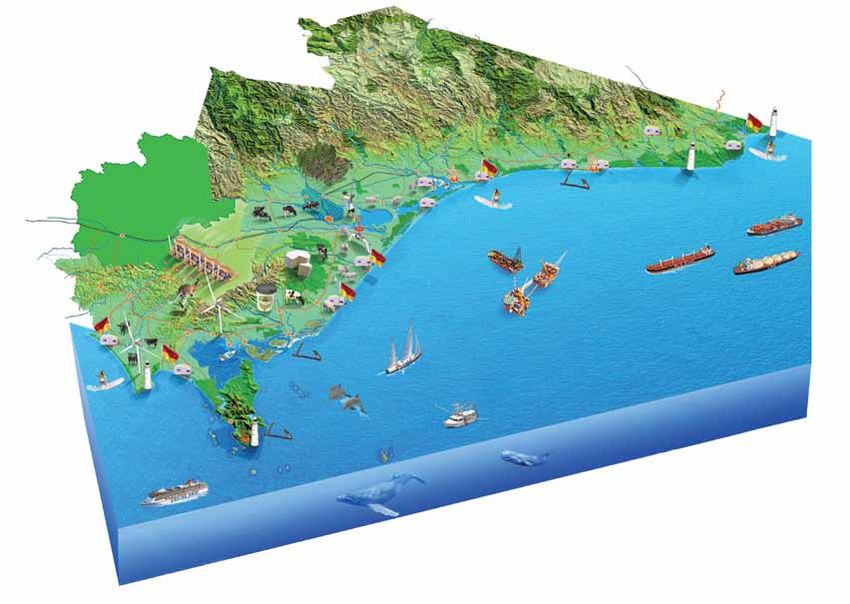
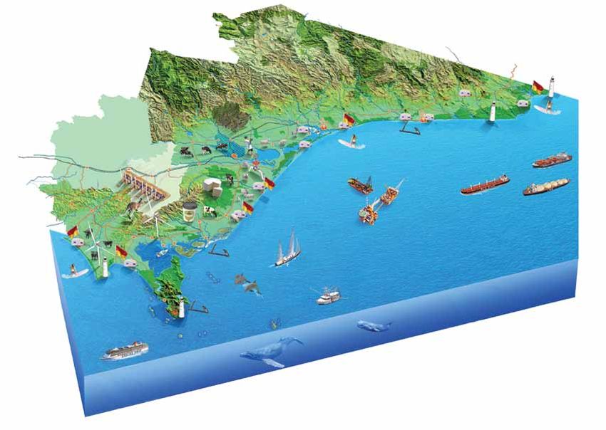
Figure 3 Indicative map of the key regional social, economic and environmental values of the Gippsland coastal region (not to scale).VALUING AND UNDERSTANDING THE COAST GIPPSLAND REGIONAL
COA STA L PLA N
9
The Board notes the work of the with high levels of salt and reduce their 2.2 Social values
Victorian Environment Assessment water needs.
Council in documenting Gippsland’s The Gippsland coastal region has a
Foreshore ecosystems bridge people’s
marine values and making wealth of social resources. The larger
movements between land and water.
recommendations for managing those towns of Warragul, Traralgon, Sale and
People enjoy swimming, surfing, diving,
values in its Marine Investigation Final Bairnsdale have social networks
fishing and boating through foreshore
report.3 The report identifies many associated with employment, training
access. People also enjoy relaxing and
different types of marine habitat in the institutions, sporting and artistic life.
walking on the foreshore. In some
Gippsland coastal region. These include Smaller coastal settlements like Venus
places, infrastructure such as pipelines
pelagic habitats (the water column Bay, Port Albert, Loch Sport and Marlo
for gas and oil need to go across
within the ocean), deep rocky reefs, have strong links to neighbourhood,
foreshore areas.
sub-tidal rocky reefs, intertidal family and place. Many locations along
shorelines, including rock platforms and 2.1.3 Hinterland Ecosystems the Gippsland coastline like Lakes
sandy beaches. Entrance, Paynesville and Mallacoota
Behind the foreshore, the region has a are major tourist towns that represent
The Victorian Government has number of nationally significant strong long-standing connections for
committed to reviewing the Coastal estuaries and coastal wetlands, as well the families and friends who share
Management Act 1995 and as ecologically significant habitats such these places.8
management arrangements for marine as the Gippsland Plains, coastal forests Port Albert, low tide
parks, coasts and bays. These initiatives and coastal heath. People are attracted to life on the Photo: Peter Jennings
will be the primary mechanism to Gippsland coast by its scenic beauty,
These habitats are represented in the recreational amenity and housing
improve the integration of marine and
parks system, good examples being affordability. Coastal settlements in
coastal planning – a key issue in the
Wilsons Promontory, Croajingolong and Gippsland range from towns such as
Victorian Coastal Strategy 2014.
the Lakes National Park. Rivers and Lakes Entrance to villages and hamlets
2.1.2 Foreshore Ecosystems estuaries of state significance occur on such as Bemm River, Gipsy Point, Sandy
both public and private land. The Point and Seaspray. Around 40 per cent
Foreshore ecosystems are particularly Mitchell, Snowy and Bemm Rivers are
important: they form the link between of Gippsland’s population is located in
all Heritage Rivers with significant villages and settlements of less than
marine, estuarine, freshwater and estuaries that are part of the engine
terrestrial areas. Foreshore habitats 500 people.
room for the carbon and nutrient cycles
include the beach, dune system, that support coastal plants and animals. The importance of the coast to the
headland scrub, mangroves and community is evidenced by the high
saltmarshes. In southern and central Gippsland, level of volunteerism. People willingly Paynesville foreshore
towns and farms have now replaced give their time to be involved in has multiple uses
Unstable low-nutrient soils, made original habitat in some ecosystems, so Photo: Destination
largely of sands that hold little water, monitoring, managing, protecting and Gippsland
not all species are fully protected in restoring coastal values.
interact with wind and salt to provide parks and reserves. Further changes in Squeaky Beach track in
the critical influences on coastal land use have the potential to affect
Wilsons Promontory
vegetation. Plant communities growing National Park
those species. Therefore it is important Photo: Garry Moore,
in these areas have evolved to cope to think through the best way to Tourism Victoria
with this challenging environment. safeguard them.
Examples include the native spinifex
that binds shifting sand dunes, as well
as moonah and sheoak trees whose
narrow leaves enable them to cope10 GIPPSLAND REGIONAL
COA S TA L P L A N
VALUING AND UNDERSTANDING THE COAST
2.2.1 Amenity values 2.2.2 Cultural heritage values 2.2.3 Aboriginal cultural
Many factors affect people’s enjoyment The Gippsland coastal region is endowed Facilities Sensory Access Vegetation heritage
of the coast and contribute to their well with significant coastal cultural heritage. Availability of clear visitor The ability to see and Abundant and healthy The Gippsland coastal region has cultural
being by providing amenity values. Some of these values are embodied in information and well hear waves, feel sand, looking vegetation (including heritage significance to its Traditional
designed and maintained taste salt and smell mangroves and sea grass
Figure 4 describes how different tangible objects, such as buildings, seaweed will increase beds) that supports animals Owners, including the Gunaikurnai.
facilities (chairs, playgrounds,
attributes of the coast can contribute to landscapes, shipwrecks, places of benches, tables, toilets, bins) satisfaction with (like birds, reptiles and fish) is Aboriginal people of the area have
the way people appreciate and value it. significance and artefacts. Some cultural amenity. This relates the most important factor in
for general use will increase
increasing satisfaction with
strong connections with the region:
satisfaction with amenity. to the naturalness at
Some aspects of amenity are tangible, values, though, are intangible: they the beach including amenity. The exact type of their stories of place, and the tens of
Note the facilities must not
such as paths and natural vegetation. include the connections to traditions detract from the ‘naturalness’ open space free vegetation that improves thousands of years of physical evidence
from obtrusive amenity differs for individual
Others are intangible, such as open many people feel, including Aboriginal, of the place. Proximity of
locations and needs to be of their presence, remind us of these
paths and access along the development.
space, views, links to places or people, maritime and agricultural history. Other beach, as well as proximity to understood at each location. links. The region contains many
or the knowledge that wildlife is forms of cultural value arise from cafes and shops. The type of Indigenous vegetation is archaeological sites, such as midden
preferable as this has benefits
present.9 holidaying and recreational customs. facilities expected at different
for other values also. sites, artefact scatters, scar trees and
locations will vary.
The sense of wellbeing people derive Connections to natural heritage, camping places. The ancestors of these
from the coast is intrinsically linked to including culturally significant landscapes groups managed traditional areas now
our ability to maintain or enhance the and biodiversity, are also meaningful. inundated; groups moved as the coast
quality and extent of natural views, The Gippsland coast has other abundant Natural line changed over thousands of years.
native vegetation and natural heritage values as well. Its rich maritime Safety SATISFACTION
Physical Form Aboriginal people have an ongoing and
landscapes. The built environment also history is a prime example. The wreck of The ability to use the
WITH
Beaches with a intimate relationship with coastal and
THE COAST
contributes to people’s enjoyment of the Sydney Cove longboat in 1797 was coast safely is an more natural physical marine environments, with continuing
the coast: it provides us with physical the first recorded wreck of a European attractive feature for a form (including sand, social, spiritual or traditional connection.
particular beach and rock pools, dune
and visual access to the natural vessel along Victoria’s coastline; it also can be enhanced by system, cliffs) and Land and sea country is a term for the
environment and its associated resulted in the first European exploration signage about hazards, without concrete whole environment, integrating land,
intangible values. of Bass Strait. the presence of a will increase
life-saving club and satisfaction with
intertidal areas and sea, and including
For example, the tracks, paths and Port Albert, established in 1841, is other facilities. amenity. natural, heritage, material and spiritual
boardwalks that allow people to move noteworthy as Gippsland’s first port. components. This connection is the basis
to, from or along the beach help Several buildings and sites in Port Albert for maintaining cultural traditions and
Water Quality Clean Beaches passing on knowledge across generations.
improve amenity. At the same time are listed in the Victorian Heritage Register.
they provide people with access to the Other sites listed on the register include: Pollution is identified as No litter or little litter in In 2010, the Gunaikurnai were recognised
an important part of the sea or around the
sights and sounds of the ocean. – the area associated with construction satisfaction with the beach will increase under the Native Title Act 1993 as Traditional
Similarly, picnic facilities enable people of the artificial entrance to the beach and can affect satisfaction with amenity. Owners of approximately 1.3 million
to enjoy the time they spend beside Gippsland Lakes at Lakes Entrance;
use such as swimming, This is based on the hectares in Gippsland extending from
boating, as well as relationship between
the coast. commercial and presence of litter and near Warragul to the Snowy River, north
– the light stations at Gabo Island, Point recreational fishing. satisfaction with to the Great Dividing Range, and
High amenity values also create health Hicks and Wilsons Promontory; and Water that is free of oils, the beach.
benefits by encouraging people to be including 200 metres of offshore sea
colours, litter and smells
more active by involving themselves in – the Paynesville government slip and will increase satisfaction territory. This area includes the coastline
bushwalking, boating, cycling, winch shed. with amenity. between Corner Inlet and the Snowy
canoeing, surfing, snorkelling, diving, River. The Gunaikurnai have a close
The wilderness values of the Gippsland
fishing and a range of other activities. relationship with, and traditional
coast are important to Victoria. There is
responsibility for, the land (Wurruk), waters
Amenity values are diminished by the nowhere else like it. Its wildness provides Figure 4 Managing visitor satisfaction with their coastal experience – key amenity values
(derived from Melbourne Water) (Yarnda) and air (Watpootjan) as a
presence of inappropriate or intrusive insights into the natural connections
connected whole that forms the basis
development, degraded environments, between land and water. It also holds
of their cultural practices.
odour, litter and noise. cultural significance for many.VALUING AND UNDERSTANDING THE COAST GIPPSLAND REGIONAL
COA STA L PLA N
11
The Gunaikurnai are also the Registered communities and protect cultural
Aboriginal Party for this area with heritage and the condition of the
statutory roles under the Aboriginal natural environment. They are also
Heritage Act 2006. interested in establishing marine ranger
The Gunaikurnai also have joint teams to achieve this.
management responsibilities for
significant areas. In their recognition
2.3 Economic values
and settlement agreement with the The commercial uses of the Gippsland
state government, several parks and coastal region include recreation, coastal
reserves were transferred to them tourism, agriculture, commercial and
under the Traditional Owner Settlement recreational fishing, shipping, renewable
Act 2010 to be jointly managed with the energy and petroleum extraction. Each
State. This includes several areas around of these has direct and indirect benefits
Gippsland Lakes (Gippsland Lakes to local and regional economies.
Coastal Park, Lakes National Park,
Gippsland’s coastal economy is based
Gippsland Lakes Reserve on Raymond
largely on natural resources. Coastal
Island), Lake Tyers State Park, Corringle
dependent economic sectors include
Foreshore Reserve, Mitchell River Captains Cove, Metung
oil and gas in Bass Strait, fisheries,
National Park, Buchan Caves Reserve, Photo: Roberto Seba,
commercial ports, shipping, commercial Tourism Victoria
New Guinea Cave (in Snowy River
boating and services supported by
National Park) and Tarra-Bulga National
coastal settlements and tourism.
Park. The agreement also includes
three per cent of output. Recreational
rights to access and use Crown land for The Gippsland coastal region is an
boating in Gippsland Lakes for example
traditional purposes including fishing, important centre for commercial and
adds $163 m to the regional economy.
hunting, camping and gathering in recreational fisheries with large
Key tourism assets in the coastal zone
accordance with existing laws. commercial fishing fleets operating out
include the Gippsland Lakes, Wilsons
of Lakes Entrance, Corner Inlet and Port
There are significant cultural values, Promontory and Mallacoota Inlet.8
Franklin. Together with the eastern zone
interests and aspirations throughout Tourism, recreation and economic
abalone fishery based at Mallacoota,
the complex of marine, coastal and development are all supported by the
Gippsland’s estimated annual commercial
national parks on and around Wilsons road network managed by Vic Roads.
catch contributes over $20 million to
Promontory.
the Victorian economy.8 The economic Non-commercial economic values
Left: Fishing nets at Fishing at Lake
Traditional Owners in the region have a contribution of recreational fishing will Lakes Entrance Tyers estuary include storm and flood protection,
strong interest in being more effectively be boosted by the Victorian Government’s Photo: Destination Photo: Tim Ellis erosion buffers and nutrient cycling.
involved in coastal management. Target One Million plan to improve fishing Gippsland These ecosystem services provide
Protecting cultural heritage is a major opportunities and increase participation. significant benefit to the community.
concern, as is sharing the responsibility For example, mangroves protect
The coastal towns of Mallacoota, Lakes settlements such as Lakes Entrance,
for caring for country. Traditional Owners against wave erosion, sea grass beds
Entrance, Port Albert, Port Welshpool, Port Welshpool and Port Franklin.
bring together natural and cultural values act as nurseries for important fish
Port Franklin and Walkerville have
by working on country. The Gunaikurnai Agriculture, forestry and fishing are species (such as bream and whiting)
long-standing ties to the commercial
seek to contribute their skills and collectively the biggest employers. They and coastal vegetation including
fishing industry, which in some cases is
knowledge in managing country as a provide 26 per cent of jobs and 13 per saltmarshes, mangroves and seagrasses
still a major economic driver for the
partner in land and sea management to cent of total regional output. Tourism fix nutrients and carbon.
settlements. Commercial fishing is still a
improve the well-being of their generates five per cent of jobs and
major source of employment for12 GIPPSLAND REGIONAL
COA S TA L P L A N
VALUING AND UNDERSTANDING THE COAST
2.4 Protecting coastal potential work. Another example is the The following chapters outline actions to
Gippsland Lakes Natural Assets Report address priority regional issues including
values Card; it identifies key environmental population changes, coordination of
The diverse and highly valued indicators such as water quality, wetlands management, and the implications of
environmental, social, cultural and and seagrass, as well as a methodology climate change, particularly the effects
economic values of the coast are for monitoring the overall health of this of flooding and erosion.
affected by a range of pressures and important area.
threats, such as increasing use, coastal
development, invasive pest plants and
animals, pollution, litter (particularly
Case study – Ninety Mile Beach
plastics) and climate change.
The management of development at Ninety Mile Beach highlights the
Under the Coastal Management Act 1995, importance of having appropriate well considered planning in place to
regional and local decision-makers must protect coastal values.
have regard for the coastal values
described above when working with The beach between Bass Strait and Lake Reeve is the longest stretch of
their communities on coastal planning uninterrupted beach in the country. Between 1955 and 1969, areas along the
and management. beach were subdivided into about 11,800 lots which were sold. It later became
Diver with Brown apparent that the physical characteristics of the land made these areas
The Victorian Coastal Strategy 2014 Leatherjacket, Corner Inlet social and economic values of the unsuitable for development. These characteristics included easily erodible
identifies a hierarchy of principles to Marine National Park
Photo: Museum of Victoria Lakes. The Strategy set the direction for coastal soils, poor conditions for effluent disposal and high quality vegetation
guide planning and decision making. future investment, coordination, and landscape.
The Board uses this as the basis for research and monitoring of the health
developing policies and actions to the Board notes the work by catchment Various planning and management programs were applied from the mid-
of the Lakes, particularly the processes
manage the factors that contribute to management authorities in estuaries 1970s with limited success. Wellington Shire Council’s Ninety Mile Beach Plan
affecting, and implications from, water
coastal values. Appendix 3 lists coastal and wetlands in response to statewide was developed to resolve the long running planning and management issue,
quality issues. It is built on working with
plans in the region. directives in the Victorian Coastal Strategy and comprises planning controls to restrict further inappropriate development
a broad range of partner organisations
2014 and the Victorian Waterway and a program to assist the transfer of private lots into public ownership.
The hierarchy of principles helps us to and groups. The Strategy was
be explicit and consistent about how Management Strategy 2013. The supported by the 2001 Gippsland Lakes The development of the Ninety Mile Beach Plan followed several years of
we refer to the different types of values, catchment management authorities’ Environmental Study10 commissioned extensive collaboration between local and state governments. The Council’s
and how we prioritise actions and regional catchment strategies and by the Board and subsequent work long-term strategy for the area was backed by a detailed Land Capability
investment. Regionally, this helps us waterway strategies identify significant about salinity issues, environmental Assessment which supported the finding that further development should be
identify where these values are most natural values to prioritise investment. watering, algal blooms and other water prohibited. This culminated in approval of a four year funding agreement with
concentrated, and, in particular, helps us Similarly, the Board notes work by local quality issues. The 2015 Corner Inlet the Victorian Government in June 2011 for $6 million for the Council’s
recognise where they may be at risk due councils in planning and managing Water Quality Improvement Plan is Voluntary Assistance Scheme.
to coastal processes or human activities. community coastal values within their another key planning document Interim planning controls were applied from June 2011 until permanent
planning schemes and urban design. addressing water quality issues. planning controls were finalised under Amendment C71 of the Wellington
Figure 5 provides a regional snapshot of
some of the values within the Gippsland They work with land holders, developers Much work has been achieved, and Planning Scheme in May 2013. This amendment applies to a 10.8 kilometre
coastal region and how these guide and public land managers to make sure continues, in identifying and monitoring section of the Ninety Mile Beach area between the settlements of Paradise
decisions by coastal planners and impacts of increasing urbanisation and the condition of the Gippsland coast, and Beach/Golden Beach and The Honeysuckles, up to Glomar Beach. It affects
managers. use of the coast are managed to meet in protecting its values. One example is more than 3,700 inappropriately subdivided lots.
community expectations. the Gippsland State of the Coast Update This amendment also ensured that inappropriate development outside
It also identifies key plans and work
The Board also notes the importance of report,11 which summarises planning, identified settlement boundaries is addressed through local policy and
done by those agencies with significant
the Gippsland Lakes Environmental management and research about the appropriate land use planning responses.
responsibilities on the coast. In particular,
Strategy7 in protecting the environmental, region’s coast and identifies futureYou can also read


