Mullaloo Foreshore Reserve Management Plan - joondalup.wa.gov.au - City of ...
←
→
Page content transcription
If your browser does not render page correctly, please read the page content below
Mullaloo Foreshore Reserve
Management Plan

joondalup.wa.gov.au
City of Joondalup Mullaloo Foreshore Reserve Management Plan

    Disclaimer
    Natural Area Holdings Pty Ltd, trading as Natural Area Consulting Management Services (Natural Area), has
    prepared this report for the sole use of the City of Joondalup and for the purposes as stated in the
    agreement between the Client and Natural Area under which this work was completed. This report may not
    be relied upon by any other party without the express written agreement of Natural Area.
    Natural Area has exercised due and customary care in the preparation of this document and has not, unless
    specifically stated, independently verified information provided by others. No other warranty, expressed or
    implied, is made in relation to the contents of this report. Therefore, Natural Area assumes no liability for any
    loss resulting from errors, omission or misrepresentations made by others. This document has been made at
    the request of the Client. The use of this document by unauthorised third parties without written permission
    from Natural Area shall be at their own risk, and we accept no duty of care to any such third party.
    Any recommendations, opinions or findings stated in this report are based on circumstances and facts as
    they existed at the time Natural Area performed the work. Any changes in such circumstances and facts
    upon which this document is based may adversely affect any recommendations, opinions or findings
    contained in this document.
    No part of this document may be copied, duplicated or disclosed without the express written permission of
    the Client and Natural Area.
City of Joondalup Mullaloo Foreshore Reserve Management Plan   1

Contents
Acknowledgements                                  2     3.3 Plant Diseases                                     30
Abbreviations and Acronyms                        3           3.3.1 Current Management Approach                 31
                                                              3.3.2 Recommended Management Action               31
Executive Summary                                 5
                                                        3.4 Fauna                                              32
1.0 Introduction                                  7
                                                              3.4.1 Fauna Survey Methodology                    32
1.1 Background                                    7           3.4.2 Fauna Habitat                               32
1.2 Natural Area Management Plans                 7           3.4.3 Native Fauna                                32
                                                              3.4.4 Non-native Fauna                            34
1.3 Study Area                                    7
                                                              3.4.5 Ecological Corridors                        34
    1.3.1 Tenure                                  7
                                                              3.4.6 Current Management Approach                 35
    1.3.2 Land Use                                7
                                                              3.4.7 Recommended Management Actions              35
1.4 Purpose                                       10
                                                        3.5 Social and Built Environment                       37
1.5 Aims and Objectives                           10          3.5.1 History and Heritage                        37
1.6 Strategic Context                             10          3.5.2 Social Value                                37
    1.6.1 Local Government                        10          3.5.3 Access and Infrastructure                   37
    1.6.2 State Government                        11          3.5.4 Anti-social Behaviour                       41
    1.6.3 Federal Government                      12          3.5.5 Recommended Management Actions              42
    1.6.4 International Conventions or Listings   13    3.6 Fire Management                                    45
2.0 Description of Physical Environment           15          3.6.1 Recommended Management Actions              47
2.1 Geology, Soils and Landforms                  15    3.7 Education and Training                             47
    2.1.1 Soils of the Swan Coastal Plain         15          3.7.1 Recommended Education and Training
    2.1.2 Acid Sulphate Soils                     17          Management Actions                                48
    2.1.3 Erosion                                 17    4.0 Implementation Plan                                49
    2.1.4 Recommended Management Actions          18    4.1 Auditing and Inspection                            49
2.2 Hydrology                                     19    4.2 Key Performance Indicators                         49
    2.2.1 Groundwater                             19
                                                        4.3 Management Plan Review                             49
    2.2.2 Drainage                                19
2.3 Climate                                       20    4.4 Recommended Management Actions                     50
    2.3.1 Climate Change                          20    5.0 References                                         52
2.4 Vegetation                                    20    Appendix 1: Bush Forever Vegetation
    2.4.1 Vegetation Complexes                    20    Structural Classes                                     55
    2.4.2 Floristic Community Types               21    Appendix 2: Vegetation Condition
    2.4.3 Vegetation Communities                  23    Rating Scale                                           56
    2.4.4 Vegetation Condition                    25    Appendix 3: Flora Species List for Mullaloo
3.0 Biodiversity Management                       27    Foreshore                                              57
3.1 Flora                                         27    Appendix 4: Fauna List for Mullaloo
    3.1.1 Flora Survey Methodology                27    Foreshore                                              60
    3.1.2 Native Flora                            27    Appendix 5: Key Weed Species in Mullaloo
    3.1.3 Weeds                                   28    Foreshore Reserve                                      63
    3.1.4 Revegetation                            28    Appendix 6: Weed Management                            66
    3.1.5 Current Management Approach             29
                                                        Appendix 7: Restoration and Regeneration               70
    3.1.6 Recommended Management Actions          29
3.2 Fungi                                         30
    3.2.1 Fungi Field Survey                      30
    3.2.2 Current Management Approach             30
    3.2.3 Recommended Management Action           30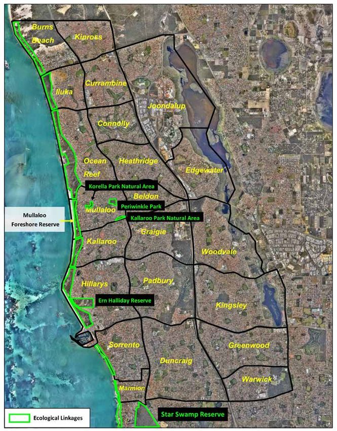
2   City of Joondalup Mullaloo Foreshore Reserve Management Plan

    Acknowledgements
    Natural Area Consulting Management Services (Natural Area) wish to acknowledge and thank the following for
    assistance and input into the plan during its development:
    •   City of Joondalup staff
    •   Mullaloo Beach Community Group Inc.
City of Joondalup Mullaloo Foreshore Reserve Management Plan   3

Abbreviations and Acronyms
Abbreviation   Description                                 Abbreviation     Description

AHD            Australian Height Datum                     EDOWA            Environmental Defenders Office of WA
                                                                            (Inc)
BAM Act        Biosecurity and Agriculture Management
               Act 2007 (WA)                               EPBC Act         Environment Protection and Biodiversity
                                                                            Conservation Act 1999 (Cwlth)
BoM            Bureau of Meteorology
                                                           GIS              Geographical information system
the City       City of Joondalup
                                                           GPS              Global positioning system
CoJ            City of Joondalup
                                                           ha               Hectare
Cwlth          Commonwealth
                                                           IUCN             International Union for Conservation of
DAFWA          Department of Agriculture and
                                                                            Nature
               Food WA
                                                           km               Kilometre
DBCA           Department of Biodiversity, Conservation
               and Attractions (previously Department      km/h             Kilometres per hour
               of Parks and Wildlife)
                                                           m                Metre
DEC            Department of Environment and
                                                           m 2
                                                                            Square metres
               Conservation (now Department of Parks
               and Wildlife)                               MBCG             Mullaloo Beach Community Group Inc.
DER            Department of Environment Regulation        Natural Area     Natural Area Consulting Management
               (WA)                                                         Services
DEE            Department of Environment and Energy        NIASA            Nursery Industry Accreditation Scheme
               (Cwlth)                                                      Australia
DPaW           Department of Parks and Wildlife (WA)       PMST             Protected Matters Search Tool
DPIRD          Department of Primary Industries and        NR Info          NR Info portal
               Regional Development (previously
                                                           WA               Western Australia
               Department of Agriculture and Food WA)
                                                           WALGA            Western Australian Local Government
DRF            Declared rare flora
                                                                            Association
DWER           Department of Water and Environmental
                                                           WAH              Western Australian Herbarium
               Regulation (previously Department of
               Environment Regulation)                     WONS             Weeds of National Significance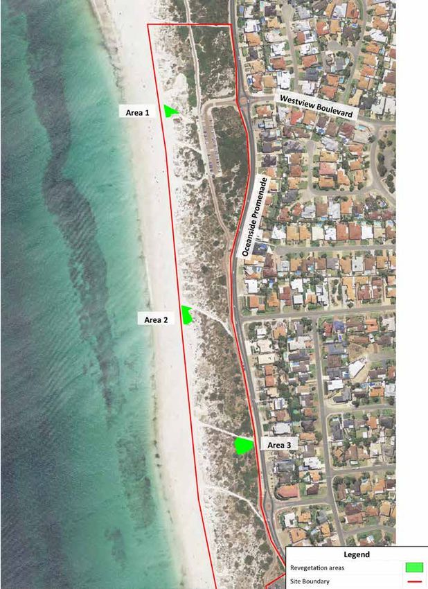
4 City of Joondalup Mullaloo Foreshore Reserve Management Plan
City of Joondalup Mullaloo Foreshore Reserve Management Plan   5

Executive Summary
                                        The site is located approximately 23km north of the Perth
Natural Area Consulting                 Central Business District in the suburb of Mullaloo. The
Management Services (Natural            site extends for 1.5km from Merrifield Place in the south
                                        to the footpath just north of the West View carpark on the
Area) was contracted by the City        boundary of Ocean Reef Foreshore Reserve in the north.
                                        It is bounded by Oceanside Promenade to the east and
of Joondalup to prepare a               the Indian Ocean to the west. The Reserve is recognised
                                        for its regional environmental significance by the City and
Management Plan for the                 by its inclusion as a portion of Bush Forever Site 325.

Mullaloo Foreshore Reserve.             The Mullaloo Coastal Foreshore Reserve is characterised
                                        by wide sandy beaches with low vegetated dunes that
This Plan identifies management         vary in width between 100m – 150m. Infrastructure
                                        includes car parks, shaded and non-shaded seating and
strategies that will assist the City    picnicking areas, barbeques, playgrounds, grassed and
                                        non-grassed recreational areas, the Mullaloo Surf
with ongoing management of              Lifesaving Club, a kiosk, and access ways to the beach.
the site over the next five years,      The majority of the native vegetation at Mullaloo
                                        Foreshore Reserve is in very good condition (Natural Area
with a focus on maintaining both        Consulting Management Services, 2017) and is part of
                                        the regional ecological linkage chain that extends along
the environmental and                   the coast from Burns Beach in the north to North Beach
recreational values of the area.        in the south. A total of 80 flora species comprising one
                                        conifer, one moss, 19 monocotyledons and 59
This Management Plan is                 dicotyledons were recorded during the 2016 Spring flora
                                        survey; none were declared rare or priority listed species
consistent with the overarching         under the Wildlife Conservation Act 1950 (WA) and/or the
                                        Environment Protection and Biodiversity Conservation Act
Coastal Foreshore Natural Areas         1999 (Cwlth). A range of mammal (four), bird (23), reptile
                                        (nine) and invertebrate (28) species were observed within
Management Plan whilst                  the reserve during the fauna surveys undertaken by
providing site-specific                 Natural Area in Spring 2016 and Autumn 2017, including
                                        the priority four listed Southern Brown Bandicoot
recommendations for                     (Isoodon obesulus fusciventer). The range and diversity of
                                        species recorded within the Reserve indicates a healthy
management of the Mullaloo              ecological community.

Foreshore Reserve.                      A number of management actions are outlined within this
                                        Plan to address key environmental threats at Mullaloo
                                        Foreshore Reserve. Management actions are to be
                                        implemented over a five-year period and include the
                                        implementation of the City’s Pathogen Management Plan,
                                        erosion control, weed control, revegetation, fire
                                        management, environmental education, and regular
                                        surveys for flora, fauna and fungi. Management actions
                                        will be implemented by the City of Joondalup in
                                        partnership with key stakeholders and community
                                        groups, where relevant.
6 City of Joondalup Mullaloo Foreshore Reserve Management Plan
City of Joondalup Mullaloo Foreshore Reserve Management Plan   7

1.0 Introduction
1.1 Background                                                  1.3 Study Area
The City of Joondalup (the City) is situated on the Swan        The study area for the Mullaloo Foreshore Reserve
Coastal Plain, approximately 30km north of the Perth            Management Plan is the Mullaloo Foreshore Reserve in
Central Business District. The City covers an area of           the suburb of Mullaloo (Figure 2). The reserve is located
96.5 kilometres that encompasses a diverse range of             approximately 23km north-west of the Perth Central
natural areas including 17 kilometres of coastal foreshore,     Business District, and covers an area of approximately
a chain of wetlands and a variety of bushland ecosystems        14.8ha which includes native vegetation, carparks, tracks
(Figure 1). The City’s southern boundary is approximately       and part of the sandy beach. The site extends south from
16 kilometres from the Perth Central Business District,         Ocean Reef Foreshore Reserve to Merrifield Place in the
and is bounded by the City of Wanneroo to the east and          south, and is bounded by Oceanside Promenade and
north, the City of Stirling to the south, and the Indian        Merrifield Place to the east, and the Indian Ocean to the
Ocean to the west.                                              west. An additional portion south of the surf club adjacent
                                                                to Merrifield Place was added to this Plan and surveyed
There are a number of regionally, nationally and
                                                                during the Autumn 2017 site assessments undertaken by
internationally significant natural areas located within the
                                                                Natural Area. This portion was not previously included in
City including Yellagonga Regional Park and a number of
                                                                the 2016 flora, fauna and fungi survey.
Bush Forever sites that contain species of high
conservation value. Significant natural areas adjacent to       1.3.1 Tenure
the City include Marmion Marine Park and Neerabup               The Mullaloo Foreshore Reserve is Crown Land with
National Park.                                                  management orders assigned to the City of Joondalup; it
The City of Joondalup is committed to conserving and            is reserved for Parks and Recreation under the
enhancing the City’s natural assets to ensure the long-         Metropolitan Region Scheme (MRS)1. The site is zoned
term protection of the environment for future generations.      Parks and Recreation under the City of Joondalup District
                                                                Planning Scheme No. 22.
1.2 Natural Area Management                                     1.3.2 Land Use
Plans                                                           The main use of the Mullaloo Foreshore Reserve is for
                                                                passive recreational purposes, including walking, dog
The City is developing Natural Areas Management Plans
                                                                exercise, photography, nature watching, and passing
and associated Action Plans to provide strategic and
                                                                through the site to access the beach area and for
operational management of the City’s natural areas to
                                                                swimming.
protect native vegetation and ecosystems. Natural Areas
Management Plans describe the potential environmental
impacts and risks of activities and environmental threats
in natural areas, and the associated management
strategies that are implemented to minimise potential
impacts.
Environmental threats have the potential to degrade
natural areas and reduce biodiversity values.
Environmental threats addressed in this Plan include
weeds, plant disease, fire, non-native fauna species,
human impacts, access and infrastructure.

1
    Department of Planning, Lands and Heritage, (2017)
2
    City of Joondalup, (2016)
8   City of Joondalup Mullaloo Foreshore Reserve Management Plan

                                                                                    Parks managed by
                                                                                    the City of Joondalup
                                                                                    Natural Areas managed by
                                                                                    the City of Joondalup
                                                                                    Mullaloo Foreshore Reserve
                                                                                    Natural Areas not managed
                                                                                    by the City of Joondalup

    Figure 1: Location of Mullaloo Foreshore Reserve within the City of Joondalup
City of Joondalup Mullaloo Foreshore Reserve Management Plan 9 Figure 2: Site location – Mullaloo Foreshore, Mullaloo
10   City of Joondalup Mullaloo Foreshore Reserve Management Plan

     1.4 Purpose                                                    1.6 Strategic Context
     The purpose of the Mullaloo Foreshore Reserve                  In order to ensure the Mullaloo Foreshore Management
     Management Plan is to:                                         Plan complements other management initiatives within
                                                                    the City, along with relevant legislation, policies, guidelines
     •    Provide information to assist the City of Joondalup in
                                                                    and documents were reviewed and are summarised in
          prioritising maintenance schedules;
                                                                    this Section.
     •    Guide the future development of the City’s
          Conservation Capital Works Program;                       1.6.1 Local Government
     •    Increase opportunities for grant funding by having a      Strategic Community Plan
          detailed schedule of projects; and                        The City of Joondalup’s Strategic Community Plan
     •    Provide guidance to City employees, contractors and       2012 – 2022 is the long-term strategic planning
          Friends Groups operating within the Mullaloo              document, which outlines the commitment of the City
          Foreshore Reserve.                                        to achieve its commitment to achieving the visions and
                                                                    aspirations of its community and stakeholders.
     1.5 Aims and Objectives                                        Environmental Plan
     The aim of the Mullaloo Foreshore Reserve Management
     Plan is to provide a framework to protect and enhance          The City of Joondalup’s Environmental Plan 2014 – 2019
     biodiversity values whilst maintaining appropriate             was developed to guide the City’s strategic response to
     community access and awareness of the natural area.            local environmental pressures.

     The objectives of the Mullaloo Foreshore Reserve               Biodiversity Action Plan
     Management Plan are to:                                        The City of Joondalup Biodiversity Action Plan
     •    Establish a baseline description of the environment to    2009 – 2019 was prepared to provide direction for
          guide future environmental planning and                   biodiversity management activities within the City, with
          recommended management actions;                           retention and enhancement of biodiversity a key priority.
                                                                    Development of individual Natural Area Management
     •    Outline key environmental threats and the impact they
                                                                    Plans was included as a management action.
          have on conservation and recreational values; and
     •    Outline management actions to address key threats,
          including monitoring and reporting.

                                    Strategic Community Plan 2012-2022

                                           Environment Plan 2014-2019

                                 Yellagonga
                                                                                 Climate Change               Waste
         City Water Plan          Integrated          Biodiversity Action
                                                                                     Strategy            Management Plan
            2012-2015            Catchment             Plan 2009-2019
                                                                                    2014-2019               2014-2017
                               Management Plan

            Pathogen                                      Bushfire Risk
                               Weed Management                                    Natural Area
         Management Plan                                Management Plan
                                  Plan 2016                                     Management Plans
           2013-2016                                         2017

     Figure 3: City of Joondalup Strategic Environmental Framework
City of Joondalup Mullaloo Foreshore Reserve Management Plan 11
Local Biodiversity Program (formerly Perth 1.6.2 State Government
Biodiversity Project) Relevant Legislation, Policies and Documents
The City of Joondalup was one of 32 local governments Aboriginal Heritage Act 1972
participating in the Western Australian Local Government
Association’s (WALGA’s) Perth Biodiversity Project, which The Act makes provision for the preservation on behalf of
documented the local biodiversity within its boundaries. the community of places and objects customarily used by
The aim of the program was to support local or traditional to the original inhabitants of Australia or their
governments to effectively integrate biodiversity descendants. The Mullaloo Foreshore Reserve is not
conservation into land use planning to protect and listed on any State or Federal Aboriginal heritage
manage local natural areas. inventory or register. However, there is an Aboriginal
heritage site north of the Reserve boundary; this is Site
As part of the Program, the City of Joondalup assessed 3673 Mullaloo Desert North.
all natural areas in 2004 and at later times using the
ecological criteria of the Natural Area Initial Assessment, Biosecurity and Agriculture Management Act 2007
resulting in a priority ranking of natural areas. The Natural The Act provides for the control of declared flora and
Area Initial Assessments include a desktop assessment fauna species (declared organisms) that are known to be
and field survey and document information such as: a significant environmental threat and makes provision for
• Vegetation complexes the management, control and prevention of these
declared plants and animals. The *One-leaf Cape Tulip
• Threatened or significant flora or ecological
(Moraea flaccida) was recorded within the Foreshore
communities
Reserve, which is listed as a category C3 declared pest
• Structural plant communities under the BAM Act 2007 (WA), which requires the
• Weed species species to be managed by the land owner to reduce the
• Vegetation condition assessment impact and spread.
• Ecological criteria ranking Bushfires Act 1954
• A viability estimate The Act makes provision for diminishing the dangers
• Fauna species observed resulting from bush fires and for the prevention, control
While funding for the program ceased in 2014, the and extinguishment of bush fires.
assessment template continues to provide a useful Cat Act 2011
assessment tool.
The Act makes provision for the control and management
Pest Plant Local Law 2012 of cats, and promotes and encourages the responsible
The purpose of the Pest Plant Local Law 2012 is to ownership of cats. Cats may be seized where they are
prescribe pest plants within the City of Joondalup that are found wandering in public areas, such as Mullaloo
likely to adversely affect the value of the property in the Foreshore Reserve, in accordance with the Cat Act 2011
district or the health, comfort or convenience of the (WA).
inhabitants of the district. Dog Act 1976
Pest plants are generally highly adaptable and will The Act makes provisions for the control of dogs in public
establish quickly after a disturbance event such as fire, or and private spaces and promotes the responsible
through unrestricted access. If pest plants are allowed to ownership of dogs. The Act requires dog owners to
establish they have the potential to out-compete the register their dogs and encompasses the ownership and
City’s unique floral biodiversity. The Pest Plant Local Law keeping of dogs and the obligations and rights of dog
2012 requires the owner or occupier of private land within owners. Local governments are responsible for
the City of Joondalup district to destroy, eradicate or administering, monitor compliance and enforcing the Act
otherwise control scheduled pest plants on notice by the within their respective districts.
City. Currently one weed species is scheduled under the
Tom Simpson Park within the Mullaloo Foreshore Reserve
Local Law – Caltrop (Tribulus terrestris). Caltrop was not
is designated as a place where dogs are not permitted
identified in the Mullaloo Foreshore Reserve.
and dogs must be on a lead at all times on the coastal
dual path by Council resolution in accordance with the
Dog Act 1976 (WA).12 City of Joondalup Mullaloo Foreshore Reserve Management Plan
Environmental Protection Act 1986 DPaW Weed Prioritisation Process 2013
The Act provides authority to the Environmental The Department of Parks and Wildlife, now the
Protection Authority (EPA) for the prevention, control and Department of Biodiversity, Conservation and Attractions,
abatement of pollution and environmental harm, for the prepared the weed prioritisation process to assist with
conservation, preservation, protection, enhancement and the on-ground management of weeds in a particular
management of the environment in Western Australia. location, considering their ecological impact, rate of
dispersal and population trend.
Heritage of Western Australia Act 1990
Wildlife Conservation Act 1950
The Act provides for and encourages the conservation of
places that have significance to the cultural heritage in the The Act provides the statute relating to conservation and
State. The Mullaloo Foreshore Reserve is not listed on legal protection of flora and fauna. Four fauna species
any State or Federal cultural heritage inventory or register. listed under the Wildlife Conservation Act 1950 are
considered to either use or possibly use Mullaloo
State Planning Policy 2.6 – State Coastal Planning
Foreshore Reserve, these being:
Policy 2013
• Australian Sealion (Neophoca cinerea) (mammal) –
The purpose of the policy is to provide guidance for
Specially Protected Fauna
decision making in the coastal zone throughout Western
Australia, with objectives including: • Black-striped Snake (Neelaps calonotos) (snake) –
Priority 3
• Considering coastal processes during development;
• Quenda (Isoodon obesulus fusciventer) (mammal) –
• Identifying appropriate and sustainable land use; Priority 5
• Providing for public use and access of coastal areas; • Graceful Sun Moth (Synemon gratiosa) (insect) –
and Priority 4
• The development of coastal reserves to protect, Quenda tracks were observed during the November –
conserve and enhance coastal biodiversity, December 2016 fauna survey undertaken by Natural
ecosystem functioning, and indigenous and Area3.
non-indigenous cultural significance.
1.6.3 Federal Government
State Planning Policy 2.8 – Bushland Policy for the
Perth Metropolitan Region Environment Protection and Biodiversity
Conservation Act 1999
This policy aims to provide direction and an
implementation framework that will ensure bushland The Act provides for the protection of the environment
protection and management issues in the Perth and the conservation of biodiversity, and for related
Metropolitan Region are appropriately addressed, purposes. Nine Environment Protection and Biodiversity
and integrated with broader land use planning and Conservation (EPBC) Act 1999 listed species have been
decision-making. recorded as occurring or potentially occurring within
Mullaloo Foreshore Reserve1, these being:
State Planning Policy 3.7 – Planning in Bushfire
Prone Areas • Australian Fairy Tern (Sternula nereis nereis) –
Vulnerable
This policy aims to implement effective risk-based land • Australian Lesser Noddy (Anous tenuirostris
use planning and development to protect life and reduce melanops) – Vulnerable
the impact of bushfire on property and infrastructure, by
identifying bushfire prone areas to be addressed in regard • Australian Painted Snipe (Rostratula australis) –
to bushfire risk management within strategic planning Endangered
documents, strategic planning proposals, and subdivision • Australian Sealion (Neophoca cinerea) – Vulnerable
and development applications. • Bar-tailed Godwit (Limosa lapponica baueri) –
Government of Western Australia ‘Bush Forever’ Vulnerable
Strategy 2000 • Bar-tailed Godwit (Limosa lapponica menzbieri) –
Vulnerable
The Strategy identifies regionally significant bushland in
the Perth Metropolitan Region to be retained, managed • Carnaby’s Cockatoo (Calyptorhynchus latirostris) –
and protected forever. The Mullaloo Foreshore Reserve Endangered
forms part of Bush Forever Site 325, which extends from • Chuditch (Dasyurus geoffroii) – Vulnerable
Burns Beach south to Hillarys. • Forest red-tailed Black Cockatoos (Calyptorhynchus
banksii naso) – Vulnerable
1
Department of Planning, Lands and Heritage, (2017)
3
Natural Area Consulting Management Services, (2017)City of Joondalup Mullaloo Foreshore Reserve Management Plan 13
While none of the above were observed by Natural Area1 Threatened Species Strategy 2015
during the November to December 2016 fauna surveys,
The Threatened Species Strategy 2015 outlines the
the Carnaby’s Cockatoo has been previously observed
Federal Government’s approach to threatened flora
on site by the Mullaloo Beach Community Group
and fauna species recovery through reversing
(MBCG).
population declines.
Australia’s Biodiversity Conservation Strategy
2010 – 2030
1.6.4 International Conventions or Listings
International Union for Conservation of Nature (ICUN)
The Strategy aims to protect biological diversity and Red List of Threatened Species
maintain ecological processes and systems.
The ICUN Red List of Threatened SpeciesTM provides
National Weeds Strategy 1997 taxonomic, conservation status and distribution
The National Weeds Strategy 1997 provides a strategic information on plants and animals that have been globally
framework for managing weeds at a national level. As evaluated using the ICUN Red List Categories and
part of the implementation of the National Weeds Criteria. The Carnaby’s Cockatoo (Calyptorhynchus
Strategy, 32 Weeds of national significance are identified latirostris) is an ICUN Red List species that has been
as nationally agreed priority plant species for control and recorded within the Mullaloo area by the MBCG
management based on the criteria of invasiveness and members.
impact characteristics, potential and current area of
spread and economic, environmental and social impacts.
The Mullaloo Foreshore Reserve contains no known
weeds of national significance.14 City of Joondalup Mullaloo Foreshore Reserve Management Plan
City of Joondalup Mullaloo Foreshore Reserve Management Plan 15
2.0 Description of Physical
Environment
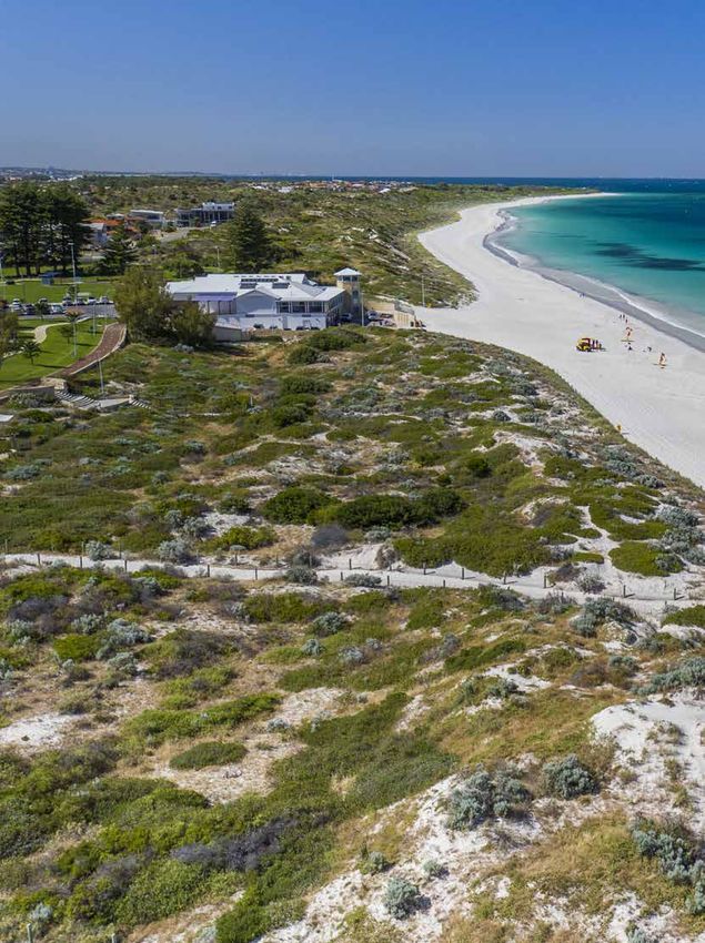
The Mullaloo Foreshore Reserve is located on the
2.1 Geology, Soils and Landforms youngest formation, the Quindalup Dune System, which
2.1.1 Soils of the Swan Coastal Plain are still being actively formed. The NR Info portal indicates
The Mullaloo Foreshore Reserve is situated within the one soil type occurs within the site boundary, namely the
City of Joondalup, which is located within the Swan Quindalup Dunes soil with one soil phase6. This is the
Coastal Plain. The Swan Coastal Plain comprises of two Quindalup South unstable sand phase which is described
major divisions, namely Swan Coastal Plain 1 – as presently unstable calcareous sand.
Dandaragan Plateau, and Swan Coastal Plain 2 – Perth The Reserve is a wide sandy beach associated with a
Coastal Plain. The Mullaloo Foreshore Reserve is located wider vegetated zone that ranges from 100m to 150m
within the Perth subregion, which is broadly characterised wide, and ranges in height from 1m – 10m Australian
as including areas of Jarrah and Banksia woodlands on Height Datum (AHD), with the highest points occurring on
sandy soils in a series of sand dunes, along with wetland the large secondary dunes, west of the vegetated zone7
areas, often within the interdunal swales4. The majority of (Figure 4).
the soils of the Swan Coastal Plain were formed by
material deposited by rivers and wind. A series of dune
systems has been formed with the youngest dunes being
the Quindalup Dunes nearest the coast, followed by the
Spearwood Dunes and the oldest Bassendean Dunes are
the farthest inland5 (Figure 5).
Figure 4: Topography at Mullaloo Foreshore Reserve - wide beach and low vegetated dunes
4
Mitchell, Williams and Desmond, (2002)
5
Government of Western Australia (2000)
6
Department of Agriculture and Food (WA) (2017b)
7
Ibid.16 City of Joondalup Mullaloo Foreshore Reserve Management Plan
Figure 5: Soils of the Swan Coastal Plain (Department of Agriculture, 2002)City of Joondalup Mullaloo Foreshore Reserve Management Plan 17
2.1.2 Acid Sulphate Soils extent of erosion via activities such as people and pets
Acid sulphate soils are naturally occurring soils that walking on the dunes instead of keeping to nominated
contain iron sulphides, primarily in the form of pyrite pathways, or the installation of infrastructure in dune
materials, formed under water logged conditions in fresh areas. Over time, projected climate change impacts are
and saline wetlands around Western Australia. If left and expected to include10:
not exposed to the air, acid sulphate soils do not pose a • Stronger winds during storm events
significant risk to humans or the environment. Exposure • Increased storm surge potential
to air causes the formation of sulphuric acid, which can
lead to the heavy metals being released into the • Lower rainfall, potentially leading to water stress on
surrounding environment8. plants and impacts to flora and fauna habitat
• Sea level rise and associated coastal inundation.
Acid sulphate soils are categorised as potential acid
sulphate soils or actual acid sulphate soils. Potential acid Accordingly, erosion is likely to be an ongoing issue that
sulphate soils have not been oxidised by exposure to air will impact on rehabilitation and ongoing maintenance
whilst actual acid sulphate soils have been disturbed or requirements. Climate change risks with the City of
exposed to oxygen and become acidic9. The risk of acid Joondalup are outlined in the Climate Change Strategy
sulphate soils is based on their likelihood of occurring 2014 – 201911, as are proposed mitigation and
within soil profiles and has been mapped by the then adaptation strategies.
Department of Environment Conservation (DEC), now the The Mullaloo Foreshore Reserve was observed to be in
Department of Water and Environmental Regulation good condition during the 2016 and 2017 site
(DWER), using available desktop information and limited assessments. The only erosion recorded occurring along
ground-truthing within areas where intensive on-ground the foredunes in the area south of the surf club (Figure 6),
mapping and soil analysis work has been undertaken. where a reduction in vegetation cover was noted and
Review of this mapping indicated that no potential acid fences were being destabilised and buried, particularly
sulphate soils are known or likely in the Mullaloo on the high foredunes in the south west. This was
Foreshore Reserve on the basis of origin of the geological exacerbated where informal pedestrian tracks lead down
units present, depth to groundwater and partial ‘ground to the beach through the dunes. Erosion causing the
truthing’ or onsite investigation. western fence line to be buried is associated with the
2.1.3 Erosion natural accretion of sand on Mullaloo Beach, with a
loader and grader likely to be required to remove excess
The major function of vegetation within coastal dune
sand in front of the fence line on a regular basis. However,
systems is stabilising sand within dunes, with erosion
the machinery and equipment can sometimes get caught
occurring where vegetative cover is absent or reduced.
on the fence resulting in damage to the fence line with
Erosion is a naturally occurring process on the coast,
some of the chain link wire being detached from the posts.
particularly during Winter months when rainfall and wind
speed increase. Human factors can increase the rate and
Figure 6: Erosion at the end of a concrete path and on higher foredunes in the south-west of the Reserve
8
Department of Environment Regulation (2016)
9
Department of Environment and Conservation, n.d.
10
City of Joondalup (2014b)
11
City of Joondalup (2014)18 City of Joondalup Mullaloo Foreshore Reserve Management Plan
While the majority of the site is currently showing minimal The Coastal Monitoring Program includes: photo
signs of erosion, ongoing monitoring is recommended to monitoring at identified sites (every six months), shoreline
prevent or mitigate any threatening processes that could mapping from aerial photography (annually), beach profile
result in future erosion. Considerations for management surveys (biennially) and analysis and report (biennially).
of erosion will include:
Erosion from both natural and human causes can largely
• Areas affected be managed through sand stabilisation and access
• Causes control. Revegetation and rehabilitation activities are often
the most effective means of stabilising sand dune areas.
• Natural, conservation and human values of the
These can include:
affected area
• Priorities for action in terms of feasibility of success in • Applying appropriate revegetation techniques that
the medium to longer term will allow plants to become established and stabilise
the soil;
• Techniques used to restore or stabilise affected areas.
• Erecting sand trap fencing that allows wind-borne
The City has undertaken a coastal hazard assessment12, sand to collect and create incipient dunes over time;
with the objective to update previous assessments and
• Applying stabilising materials such as biodegradable
provide consistent assessment across the whole City.
jute or coir matting, brushing or mulch to exposed
The City’s Coastal Monitoring Program was established in
areas to provide a stable surface that will allow
2015/16 to monitor shoreline movements over time. The
seedlings to become established and grow;
Program aims to:
• Use of signage to provide information about erosion
• Provide valuable information that can be used to and the need to keep off the dunes; and
inform planning decisions in the coastal zone;
• Establishing barriers to deter human (and their pets)
• Inform maintenance and asset replacement access to vegetated areas, and allowing bare areas
schedules of coastal infrastructure; to regenerate.
• Provide early warning of any increased vulnerability
of assets;
• Guide the timing and need for coastal adaptation
works
• Identify the requirement for updates to hazard and
vulnerability assessments; and
• Improve the City’s understanding of coastal
processes and monitor actual shoreline erosion
compared to modelled erosion.
2.1.4 Recommended Management Actions
Action Detail
Holistic Erosion issues to be considered holistically, with the most appropriate management options
consideration of determined on a case by case basis and recognising that all exposed sand does not need to
erosion be covered by vegetation, reflecting what would occur within a natural environment.
Brushing Brushing materials will be of suitable species that do not contain seed pods or other materials
that can propagate and result in the presence of weeds at the site.
Early consideration Address erosion issues as early as possible to avoid larger areas to be rehabilitated later.
of erosion
Wider context Consider erosion in the wider context of climate change impacts that could occur over time.
12
MP Rogers & Associates P/L, 2016City of Joondalup Mullaloo Foreshore Reserve Management Plan 19
2.2 Hydrology Groundwater levels in the superficial aquifer have been
declining over recent years due to pressure from
2.2.1 Groundwater extraction and the impacts of climate change.
The City of Joondalup is located on Perth’s largest source
of groundwater, the Gnangara Groundwater System, 2.2.2 Drainage
comprising four main aquifers: superficial (shallow, Mullaloo Foreshore Reserve has no natural or man-made
unconfined), Mirrabooka (deeper, semi confined), water bodies present. Depth to groundwater in the site
Leederville (deep, mostly confined) and the Yarragadee ranges from 0m – 9m below ground level14, which is
(deep, mostly confined). The Gnangara Mound extends consistent with a site located on the coast, where
across most of the superficial aquifer and refers to the groundwater enters the ocean (Figure 8).
water table creating a mound shape (Figure 7).
Figure 7: Gnangara Groundwater System13
Natural surface contours
depth to water
Watertable contours
0 metres = Sea level
depth of water
Base of superficial aquifer
Figure 8: Groundwater Depth Explanation15
13
Department of Water (n.d.)
14
Department of Water (2017)
15
Department of Environment (2004)20 City of Joondalup Mullaloo Foreshore Reserve Management Plan
180 35
160
30
140
25
120
Temperature oC
Rainfall (mm)
100 20
Rainfall (mm)
80 15 Max Temp
60 Min Temp
10
40
5
20
0 0
Jan Feb Mar Apr May Jun Jul Aug Sep Oct Nov Dec
Month
Figure 9: Climate data for Perth, Station ID 009021, (1994 – 2017)
2.3 Climate 2.4 Vegetation
The City of Joondalup experiences a Mediterranean Flora surveys were undertaken by Natural Area in
climate of hot dry Summers with an average temperature September 2016 and additional areas in April 2017, with
of 30.9oC during the day and mild wet Winters with an outcomes provided in this section.
average daytime temperature of 18.5oC. The average
annual rainfall from 1944 to 2017 was 766.1mm, with
2.4.1 Vegetation Complexes
approximately 80% of the annual rainfall occurring Vegetation complexes are classified by the soil and
between the months of May and September (Figure 9)16. landforms contained in medium to large areas along the
Swan Coastal Plain. Regional scale mapping indicates
2.3.1 Climate Change that the Mullaloo Coastal Foreshore Reserve occurs
The City of Joondalup is located in the south-west of within the ‘Quindalup Complex on Quindalup Dunes’
Western Australia, and which is experiencing impacts (Figure 10). The Quindalup Complex is a coastal dune
associated with climate change such as rising complex consisting mainly of two alliances – the strand
temperatures, decreased rainfall and sea level rise. and foredune alliance and the mobile and stable dune
According to the Climate Commission, Western alliance. Local variations include the low closed forest of
Australia’s temperature has been increasing steadily since Melaleuca lanceolata – Callitris preissii and the closed
the 1950s, with an overall rise of approximately 0.8oC17. scrub of Acacia rostellifera19.
The City has developed the draft Climate Change The pre-European extent remaining within the Swan
Strategy 2014 – 201918 to guide climate change activities, Coastal Plain IBRA region for the Quindalup Complex is
both in terms of mitigation and adaptation, in coming 55.38%20. The pre-European extent remaining within the
years. Strategies to be adopted include: City of Joondalup is 12.55%21.
• Reduce greenhouse gas emissions
• Offset carbon emissions
• Improve understanding of future climate scenarios
• Identify risks and how they can be managed
• Support the community to prepare and adapt to
climate change.
16
Bureau of Meteorology (2017) Climate Commission, (2011) 19
WALGA (2013)
17
City of Joondalup, (2014b) 20
WALGA (2010)
18
Heddle et al. (1980) 21
WALGA (2010)City of Joondalup Mullaloo Foreshore Reserve Management Plan 21
2.4.2 Floristic Community Types According to Natural Area (2017), one FCT had a 22%
Seven Floristic Community Types (FCTs) have either been similarity to the Mullaloo quadrats recorded on site during
sampled within or inferred to occur within Bush Forever 2016 site assessments, which was FCT 19 – Sedgelands
Site 325 according to Bush Forever Vol. 2, with five likely in Holocene dune swales. This community is listed as
to occur on site due to soil and landforms present22. threatened under the Wildlife Conservation Act 1950 (WA)
These include: and as endangered under the Environmental Protection
and Biodiversity Conservation Act 1999 (Cwlth)23. The
• 29a Coastal shrublands on shallow sands (sampled low similarity is not considered to be significant and a
within Bush forever Site 325) closer look at the common species found by Gibson et al.
• 29b Acacia shrublands on taller dunes (inferred) (1994) in this community type showed the only flora
• S11 Northern Acacia rostellifera — Melaleuca species consistent with the Mullaloo data were the weed
acerosa shrublands (inferred) species. Therefore, this community type is unlikely to be
present.
• S13 Northern Olearia axillaris — Scaevola crassifolia
shrublands (inferred)
• S14 Spinifex longifolius grasslands and low
shrublands (inferred).
22
Government of Western Australia (2000)
23
Natural Area Consulting Management Services (2017)22 City of Joondalup Mullaloo Foreshore Reserve Management Plan
Figure 10: City of Joondalup Vegetation ComplexesCity of Joondalup Mullaloo Foreshore Reserve Management Plan 23
2.4.3 Vegetation Communities
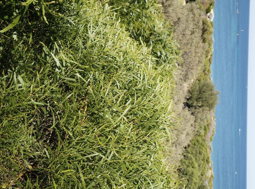
Three vegetation types were recorded during the 2016 Spring flora survey undertaken by Natural Area, these have
been described in Table 1 and illustrated in Figure 11. The dominant vegetation type on site is Olearia axillaris and
Scaevola crassifolia Shrubland. No threatened or priority ecological communities were identified within the site. The
structural classes used to describe vegetation type are provided in Appendix 1. The portion of the reserve south of the
surf club adjacent Merrifield Place was surveyed during the 2017 site assessments and an additional vegetation type
Acacia cyclops Shrubland was recorded (Table 1– Figure 11).
Vegetation Description Photo
Type
Acacia Shrubland over mixed shrubland; Scaevola
rostellifera crassifolia, Rhagodia baccata and Spyridium
globulosum and a weedy grass understory; *Bromus
diandrus. This vegetation type occurs on the tertiary
dunes at the eastern edge of the site.
Acacia Tall Shrubland over mixed shrubland of Olearia
cyclops axillaris, Rhagodia baccata and Scaevola crassifolia,
and an understory of Lepidosperma gladiatum and
mixed herbs and grasses. This vegetation type
occurs in the tertiary dunes south of the surf club,
adjacent Merrifield Place.
Spinifex Open Grassland with sparse patches of Olearia
hirsutus and axillaris. This vegetation type occurs along the
*Thinopyrum foredunes on the western edge of the site.
distichum
Olearia Open Shrubland over a grassy herb under storey;
axillaris and *Lagurus ovatus, Ficinia nodosa and weedy herb;
Scaevola *Trachyandra divaricata. This vegetation type occurs
crassifolia on the secondary dunes in between the other two
vegetation types along the entire length of the site.
*Denotes introduced species
Table 1: Vegetation types within the Mullaloo Foreshore24 City of Joondalup Mullaloo Foreshore Reserve Management Plan
Figure 11: Vegetation types Mullaloo Foreshore, MullalooCity of Joondalup Mullaloo Foreshore Reserve Management Plan 25
2.4.4 Vegetation Condition vegetation condition were primarily found in the foredunes
Vegetation condition assessments were undertaken by and primary dunes closest to the beach. These areas had
Natural Area in 2012, with improvements in vegetation less vegetation cover and more weed species, with
condition noted during the on-ground site assessments in pockets of degraded areas where weed species were the
2016, and additional areas south of the surf club in 2017. dominant vegetation present (Figure 13). Patches of
Vegetation condition assessments include observations degraded and completely degraded vegetation were
regarding the numbers of native species, weed cover, recorded in previously cleared areas around the periphery
species diversity, amount of understorey, health condition of the vegetated dunes, in the foredunes and higher
of populations and physical disturbance. secondary dune and in the sump/drainage area
(Figure 12). The secondary and tertiary dunes were
Vegetation condition ranged from completely degraded to mostly in very good condition with higher levels of
very good within the Mullaloo Foreshore Reserve, with the vegetation cover and species diversity. Revegetation
majority of the site classified as Very Good; none was noted across the dunes in 2016 has improved vegetation
considered to be in excellent or pristine condition condition and increased vegetation cover in previously
(Table 2 – Figures 13, 14 and 15). The areas with reduced open areas.
Vegetation Completed Degraded Good Very Good Excellent Pristine Total
Condition Degraded
Area (ha) 0.21 0.32 3.54 8.57 0 0 12.64
Area (%) 1.7 2.5 28 67.8 0 0 100
Table 2: Vegetation Condition at Mullaloo Foreshore Reserve26 City of Joondalup Mullaloo Foreshore Reserve Management Plan
Figure 12: Vegetation condition Mullaloo Foreshore, MullalooCity of Joondalup Mullaloo Foreshore Reserve Management Plan 27
3.0 Biodiversity Management
Mullaloo Foreshore Reserve supports a range of flora and the occurrence and distribution of flora species and
fauna species, and provides an important ecological vegetation communities. Information obtained from flora
linkage to adjacent coastal reserves. The long-term surveys is used as a baseline to monitor the ecological
protection of biodiversity values within the reserve is health of flora populations and vegetation communities.
critical to ensure the conservation of this habitat. The Natural Area was engaged to undertake a desktop and
protection and enhancement of biodiversity within the field flora survey of the Mullaloo Foreshore Reserve in
reserve also benefits the community through the provision September 2016. A total of 80 plant species were
of ecological services, including: recorded within the Reserve, including 37 native (46%)
and 43 (54%) introduced species26.
• The production of oxygen and capture of carbon
dioxide; 3.1.1 Flora Survey Methodology
• Noise and air quality regulation; Desktop and on-ground flora survey methodology for the
• Cooling of urban environments; Mullaloo Foreshore Reserve was undertaken by Natural
• Supporting seed dispersal and pollination; and Area in September 2016 in accordance with EPA
Technical Guide – Flora and Vegetation Surveys for
• A number of recreational and cultural experiences24. Environmental Impact Assessment (December 2016). The
Flora, fauna and fungi surveys are undertaken as part of survey methodology undertaken included Natural Area
the management plan review every five years within the botanists setting up a series of quadrats in each
Mullaloo Foreshore Reserve. vegetation type and documenting27:
A number of environmental threats pose a risk to the • The landscape characteristics including soil type, soil
biodiversity of the Mullaloo Foreshore Reserve. The key colour, aspect, slope, and topography;
environmental threats include: • Leaf litter depth;
• Weeds • Percentage vegetative cover and percentage bare
• Pathogens and disease ground;
• Non-native fauna species • Recording vegetation type and condition;
• Human impacts • Presence of native and non-native flora species
present, including significant flora, along with habit,
• Access and infrastructure
life form, percentage cover and height; and
• Fire
• Walking the site to record incidental sightings of
Management strategies to mitigate the effects of key species not present in quadrats.
environmental threats have been established and are
3.1.2 Native Flora
discussed in the following sections. There are other
additional environmental threats that are out of the scope Native flora is an important part of the Mullaloo Foreshore
of this Plan and thus not addressed, such as climate Reserve ecosystem, providing habitat and resources for
change and groundwater decline. fauna present. Reduction in flora species or vegetation
cover can lead to a loss of fauna that depend on it for
resources and shelter. A total of 37 native plant species,
3.1 Flora of which none were threatened or priority species, were
The Mullaloo Foreshore Reserve is located in the recorded within the Reserve28.
Southwest Australian biodiversity hotspot, which is one of
the world’s 35 biodiversity hotspots. It extends from
Shark Bay in the North to Israelite Bay in the south, with
over 2,900 endemic plant species occurring within the
region. Approximately 30% of the original vegetation
extent of this area remains, with habitat loss primarily due
to agricultural expansion25.
Flora surveys enable collection of scientific data related to
24
City of Joondalup (2014a)
25
Conservation International (2017)
26
Natural Area Consulting Management Services (2017)
27
Natural Area Consulting Management Services (2017)
28
Ibid.28 City of Joondalup Mullaloo Foreshore Reserve Management Plan
3.1.3 Weeds A total of 43 weed species were recorded within the
Weeds can be native or introduced species that have Mullaloo Foreshore Reserve by Natural Area during the
colonised an area where they did not originally exist. An September 2016 surveys. No weeds of national
environmental weed generally reproduces quickly, and significance (WoNS) were recorded, although one
requires action to reduce its negative impact on category C3 declared pest, the One-leaf Cape Tulip
economic, social and environmental values of the area. (Moraea flaccida) listed on the WAOL under the
Weeds are commonly introduced and distributed within Biosecurity and Agriculture Management Act 2007 (WA)
bushland areas through seed dispersal by water, wind, (BAM Act), was recorded within the Reserve. Three
animals such as birds, fire, the dumping of garden waste, species are listed on the City of Joondalup’s priority weed
and human or vehicle movement in natural areas. Weeds list, namely Geraldton Carnation Weed (Euphorbia
can have major economic, environmental and social terracina), Gazania (Gazania linearis) and Rose
impacts in Australia and can: Pelargonium (Pelargonium capitatum).
• Displace native plant species; 3.1.4 Revegetation
• Alter nutrient cycling and soil quality within The City of Joondalup encourages natural bushland
ecosystems; regeneration through weed management and
conservation fencing to allow the vegetation to
• Harbour pests and diseases;
re-establish itself and maintain species diversity and
• Increase fire fuel loads; populations. Revegetation is undertaken on an as
• Impact negatively on native flora and fauna and required basis in degraded, completely degraded, or
their habitats; and good areas where further planting is considered to be
• Compete with native species for resources29. beneficial using local provenance species.
Over 28,000 known alien plant species have been Weed control and revegetation has occurred within the
introduced to Australia with approximately 10% now Mullaloo Foreshore Reserve, which has increased
being established in the environment30. Garden plants are biodiversity and reduced weed abundance. Areas of
the main source of Australia’s weeds, accounting for 66% degraded (Figure 13) and good vegetation condition that
of recognised weed species31. would benefit from planting along with a proposed
planting list is provided in Appendix 7, including species
that are not present or under-represented on site.
Figure 13: Area of Degraded vegetation condition suitable for revegetation activities
29
Department of the Environment (2015)
30
Groves, Bowden and Lonsdale (2005)
31
DSEWPC (2013)City of Joondalup Mullaloo Foreshore Reserve Management Plan 29
3.1.5 Current Management Approach • High priority weed according to the Swan Regional
The City undertakes an integrated approach to weed Ranking;
management, including: • Pest plant under Local Government Act 1995 (WA);
• Prevention of weed introduction through hygiene • Major threat to vegetation;
measures; • Major threat to the structure of vegetation
• Regular monitoring and reporting of weed communities; and
populations; • Contribute to a high fuel load, for example dry
• On ground weed control, including prioritisation of grasses.
natural areas and priority weeds to target; A list of weeds and their priority rating according to the
• Community education initiatives; DBCA Swan Regional Ranking is provided in Appendix 5,
• Fire prevention measures; and with the recommended weed treatment methodology for
high priority weed species detailed in Appendix 6.
• Hand weeding by bushland friends group volunteers
and contractors. The City of Joondalup Weed Management Plan has been
adopted and provides an ongoing strategic approach to
Weed monitoring is conducted by the City every six
the management of natural areas and parks in order to
months at the Mullaloo Foreshore Reserve to establish
reduce the incidence of weeds. A number of education
the extent and distribution of weeds species and to
initiatives are undertaken to raise the awareness of weeds
identify priority weeds.
with the community, these include:
In accordance with Annual Maintenance Schedules and
• Delivery of gardening workshops;
Weekly Maintenance Schedules, on ground weed
management occurs through weed spraying and hand • Development and distribution of two weed brochures –
weeding methods. In addition to this, contractors are Environmental Weeds and Garden Escapees
engaged to spray weeds and hand weed. City of (available in hard copy and on the City’s website); and
Joondalup personnel act in accordance with internal • Weed education workshops for local Friends Groups.
spraying procedures and conduct trials periodically to
3.1.6 Recommended Management Actions
evaluate the most effective management methods.
Resources, such as the DBCA FloraBase website or To monitor, conserve and protect native flora in the
Southern Weeds and their Control (DAFWA Bulletin Mullaloo Foreshore Reserve, the following management
4744), are also consulted in regard to weed control. actions are proposed.
Environmental weeds are classified as priority by the City
if they meet any of the following criteria:
• Weed of national significance (WoNS);
• Declared plant listed under the Biodiversity and
Agriculture Management Act 2007 (WA);
Action Detail
Weed monitoring Continue to undertake weed monitoring every six months.
Targeted weed control Continue to undertake a targeted weed control program, as described in Appendix 6.
Ongoing weed control Continue to undertake coordinated approach to regular weed control by implementing
the Annual Maintenance Schedule.
Weed Management Plan Implement the City of Joondalup Weed Management Plan when it is finalised to provide
an ongoing strategic approach to the management of natural areas in order to reduce
the incidence of weeds.
Restoration Conduct restoration as outlined in the Revegetation Strategy in Appendix 7.
Friends Group Continue to support the activities of the MBCG.30 City of Joondalup Mullaloo Foreshore Reserve Management Plan
3.2 Fungi 3.3 Plant Diseases
It is estimated that there are 10 times more species of Vegetation can be subject to diseases that result in plant
fungi than plants in the world, equating to approximately health decline and potentially death in the longer term.
140,000 fungi and 14,000 plant species in Western pathogens are the organisms such as fungi, bacteria and
Australia. The amount of species of fungi present in viruses that cause plant diseases; with many introduced
bushland can be an indicator of ecosystem health. Fungi into new areas through movement of infected plant
are strongly interconnected with plants and animals as material or soils, whilst some are naturally occurring in the
fungi are recyclers that break down litter and debris to soil. Some pathogens will result in rapid plant death while
provide nutrients for plants. Native plants such as others will lead to the slow decline in plant health over
eucalypts, wattles and orchids have beneficial time34.
partnerships with fungi. Fungi also provide food and/or
Phytophthora dieback is a water-borne fungus and the
habitat for fauna such as bandicoots and other fauna
most common plant disease encountered on the Swan
including invertebrates32.
Coastal Plain, with the most common species
Fungi surveys are important to provide baseline encountered being Phytophthora cinnamomi. While
information, and to highlight changes in fungi occurrence Phytophthora cinnamomi is considered the most
over time. Undertaking surveys also enables comparison destructive, other varieties are being described which
of ecological data with other City of Joondalup natural may have similar impacts, such as Phytophthora
areas. The most common time to see the fruiting bodies multivora which is known to attack a variety of species
of fungi is after Autumn and Winter rains. including Eucalyptus gomphocephala, E. marginata and
Agonis flexuosa and a range of Banksia species35. The
3.2.1 Fungi Field Survey nature of the vegetation combined with the presence of
No fungi species were identified within the Mullaloo limestone based soils within the foreshore reserve mean
Foreshore Reserve during the September 2016 that Phytophthora cinnamomi is unlikely. However,
opportunistic field survey conducted by Natural Area33. Phytophthora multivora is known to be tolerant of alkaline
This was most likely due to the timing of survey activities, conditions as it has been found in Tuart forests underlain
which was not the optimum time to see fruiting bodies as by limestone soils south of Mandurah and as far as Cape
it was too late in the year and the weather warm and dry. Naturaliste, where it has been associated with individual
Fungi species likely to occur are expected to be similar to spot deaths and areas of tree decline36. Phytophthora
those observed within the Marmion Coastal Foreshore multivora has been recorded in urban areas of Perth,
Reserve and other City of Joondalup bushland areas. including inland dune systems and within the City’s parks.
3.2.2 Current Management Approach If suspected within the foreshore reserve or other natural
areas, it should be treated in the same manner as
The City of Joondalup currently monitors fungi in the Phytophthora cinnamomi.
Reserve through surveying for incidental sightings of fungi
species every five years as part of the flora, fauna and Armillaria luteobubalina has been previously identified
fungi survey. within a number of the City’s parks. Armillaria is a
soil-borne fungus that causes root rot of a wide variety of
3.2.3 Recommended Management Action plants including many species of native flora. The fungus
To monitor fungi health in the Mullaloo Foreshore is native to Australia and can cause major damage to
Reserve, the following management action is proposed: natural ecosystems. Armillaria luteobubalina is commonly
known as the ‘Honey Fungus’ due to the colour of the
Action Detail fruiting body seen above the ground during certain times
of the year (Figure 14). Fruiting bodies (mushrooms) are
Opportunistic Continue to undertake opportunistic not evident at all infected sites and their presence is
fungi survey fungi sightings during other site usually a sign that the fungus is well established in that
activities. area37.
At present, there is no reliable mechanism for the
complete eradication of Phytophthora species and the
control of Armillaria luteobubalina is both expensive and
labour intensive.
32
Bougher (2009)
33
Natural Area Consulting Management Services (2017)
34
City of Joondalup (2012)
35
Scott et al, (2009)
36
Ibid.
37
Smith and Smith, (2003)You can also read


