Severn River Basin District Flood Risk Management Plan 2015-2021 PART A - Background and River Basin District wide information - December 2015
←
→
Page content transcription
If your browser does not render page correctly, please read the page content below
Severn River Basin District
Flood Risk Management Plan
2015-2021

PART A - Background and River Basin
District wide information
December 2015
Published by:

Environment Agency                            Natural Resources Wales
Horizon house, Deanery Road,                  Cambria house, 29 Newport Road,
Bristol BS1 5AH                               Cardiff CF24 0TP
Email: enquiries@environment-agency.gov.uk    Email: enquiries@naturalresourceswales.gov.uk
www.gov.uk/environment-agency                 http://www.naturalresourceswales.gov.uk

Further copies of this report are available   Further copies of this report are available
from our publications catalogue:              from our website:
www.gov.uk/government/publications            http://www.naturalresourceswales.gov.uk

or our National Customer Contact Centre:      or our Customer Contact Centre:
T: 03708 506506                               T: 0300 065 3000 (Mon-Fri, 8am - 6pm)

Email: enquiries@environment-agency.gov.uk.   Email: enquiries@naturalresourceswales.gov.uk

© Environment Agency 2015                     © Natural Resources Wales

All rights reserved. This document may be     All rights reserved. This document may be
reproduced with prior permission of the       reproduced with prior permission of Natural
Environment Agency.                           Resources Wales.

                                              ii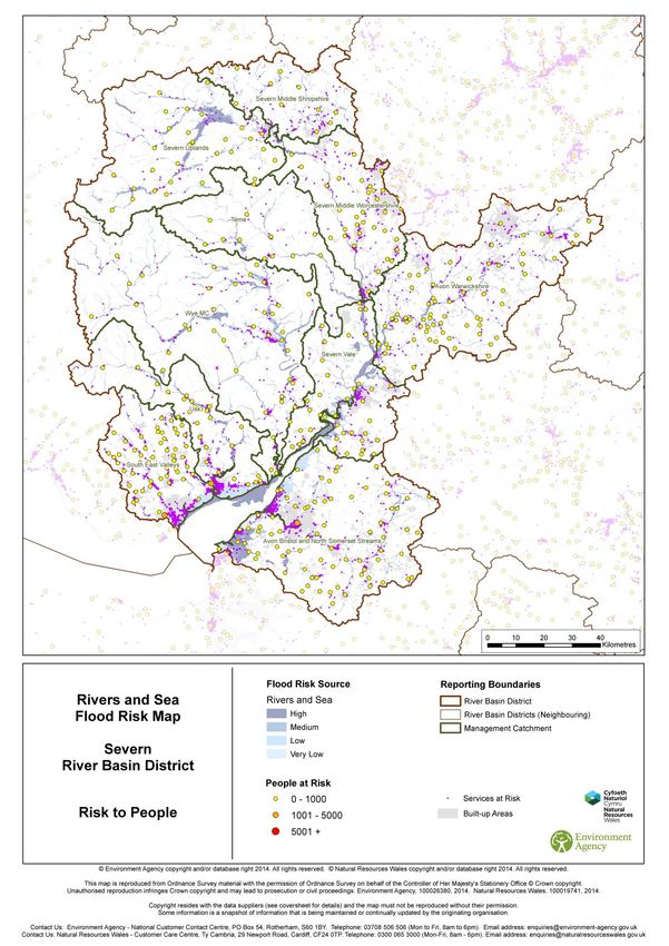
Severn River Basin District
Flood Risk Management Plan
December 2015

Ironbridge, 2010. Copyright John Foulds

                                          iii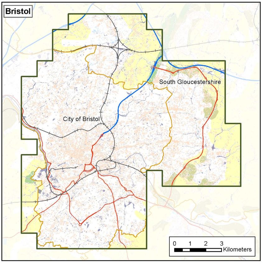
This is a joint plan prepared by the following Risk Management Authorities:

                                                iv
Foreword
The 2013 / 14 winter storms and flooding had significant impacts on many communities,
businesses, infrastructure and the environment within the Severn River Basin District (RBD). In
the future there could be more extremes in the weather with a changing climate leading to more
frequent and more severe flooding.
Investment in flood risk management infrastructure not only reduces the risks of flooding but also
supports growth by helping to create new jobs, bring confidence to areas previously affected by
floods and creating and restoring habitats.
Risk Management Authorities (RMAs) are committed to producing Flood Risk Management Plans
(FRMPs) required by the EU Floods Directive by December 2015. This FRMP is an important part
of meeting that objective and aligns with the guiding principles of the National Flood and Coastal
Erosion Risk Management Strategy.
The FRMP will help promote a greater awareness and understanding of the risks of flooding,
particularly in those communities at high risk, and encourage and enable householders,
businesses and communities to take action to manage the risks. The FRMP will provide the
evidence to support flood and coastal risk management decision making. The highest priority is to
reduce risk to life.
Measures (actions) in FRMPs do not all have secured funding and are not guaranteed to be
implemented. Money is allocated to RMA measures based on current Government policy that gives
the highest priority to the areas at highest risk. The funding for flooding is devolved so RMA
measures are funded by DEFRA in England, in Wales they are funded by Welsh Government.
This document has been produced in consultation with professional partners. The Flood Risk
Management Plan (FRMP) sets out the proposed measures to manage flood risk in the Severn
RBD from 2015 to 2021 and beyond.
This plan should be read in conjunction with the following:
Welsh lead local flood authority flood risk management plans, including Blaenau Gwent
County Borough Council, Cardiff City Council, Caerphilly County Borough Council,
Rhondda Cynon Taff County Borough Council, Merthyr Tydfil County Borough Council
and Torfaen County Borough Council;
Lead Local Flood Authority Local Strategies listed in Part B.
In England and Wales, RMAs include Natural Resources Wales, the Environment Agency, Lead
Local Flood Authorities (LLFAs), district councils (where there are no unitary authorities), internal
drainage boards, water companies and highway authorities. These RMAs work in partnership with
communities to reduce the risk of flooding. The Environment Agency and Natural Resources Wales
would like to thank the organisations listed on the previous pages for their contributions and
feedback during consultation.
Flood risk in England and Wales will continue to change as a result of a growing population and a
changing climate. There are many ways to manage flood risk including maintaining and building
new flood defences, building flood resilient homes and working more closely with nature to restore
flood plains. Flood risk management planning is not new and RMAs have been able to draw on the
experience of partners and earlier plans.
The FRMP also sets out how these measures can contribute to improving the environment and
how they support the objectives of River Basin Management Plans (RBMPs) and specifically the
Severn RBMP that Natural Resources Wales and the Environment Agency has produced in
parallel with this FRMP.
Gareth O’Shea Mark Sitton Kent
Executive Director for Operations South Director of Operations, West
Natural Resources Wales Environment Agency
v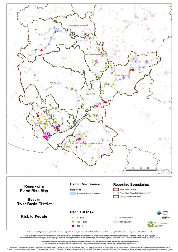
Format of the flood risk management
plan
Flood Risk Management Plans have been divided into four sections to help readers identify and
access information relevant to them. This is Part A. The plan is divided into the following four
parts:
Name                                         Audience
Summary Document                             For those who want a high level overview of
                                             the plan

Part A: Background and river basin           For those who need some legislative
district wide information                    background and RBD wide, high level
                                             information
Part B: Catchment Summaries                  For those who want the detail of the sub-
                                             areas and flooding statistics. This section
                                             includes the catchments based on Water
                                             Framework Directive (WFD) management
                                             catchments, Flood Risk Areas (identified
                                             through the Preliminary Flood Risk
                                             Assessment) and other strategic areas
                                             across the RBD
Part C: Appendices                           For those who want to see the detailed
                                             program of work for individual communities
                                             in England

The measures (actions) that relate to Wales only are found in the Welsh Strategic Area. The
measures tables for all Welsh catchments are reported in Part B and not in the Part C:
Appendices, as the Welsh measures relate to the highest risk communities by catchment. The
Welsh measures are continually updated and the measures in this plan are indicative although
correct at the time of publication. The RBD-wide measures that affect Welsh Catchments are found
in the Appendices.

The measures that relate to the River Basin District, the English Strategic Area and English
catchments are contained in the appendices.

The other parts of the flood risk management plan are located on gov.uk
(https://www.gov.uk/government/publications/severn-river-basin-district-flood-risk-
management-plan)

                                                 vi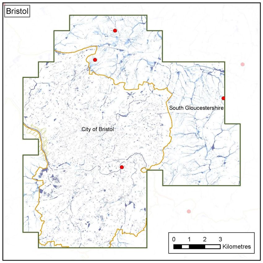
The layout of this document
This is Part A, Background and river basin district wide information – this explains what
FRMPs are and how the Environment Agency and Natural Resources Wales have developed them
and then describes the Severn RBD.

Section 1: What is flood risk and who manages it
This explains what flood risk is, who is responsible for managing the risk and what their roles are.

Section 2: What is a Flood Risk Management Plan
What a FRMP is, why the Environment Agency and Natural Resources Wales are producing a
FRMP and describes the kind of information that is included in the FRMP.

Section 3: how has the plan been developed?
Section 3 describes how in partnership the Environment Agency, Natural Resources Wales, LLFAs
and other RMAs have prepared this FRMP.

Section 4: how to manage risk
Section 4 describes some of the terminology used, such as ’conclusions’, ’objectives’ and
‘measures’, and how they relate to flood and coastal erosion risk management.

Section 5: getting to know the river basin district
Section 5 of the plan introduces the Severn RBD. The ‘sub-areas’ are also introduced which divide
the RBD further.

Section 6: key flood risk issues in the river basin district
The flood and coastal erosion risks are set out for the RBD in section 6.

Section 7: the sub-areas
Section 7 introduces each of the sub-areas in turn. This section outlines the catchments based on
Water Framework Directive (WFD) management catchments, which make up the RBD, then the
FRAs (identified through the Preliminary Flood Risk Assessment) across the RBD.

Section 8: conclusions, objectives and measures for the Severn
RBD
Section 8 sets out the risk conclusions, objectives and measures for the RBD.

Section 9: implementing the plan, monitoring and reporting
Section 9 sets out the proposals for implementing the plan, including co-ordination with the
implementation of the RBMPs prepared under the WFD. Section 9 concludes with how the
measures will be monitored and reported.

Find out more
Throughout this document you will be directed via hyperlink to more detailed sources of information
using 'find out more’ boxes.

                                                 vii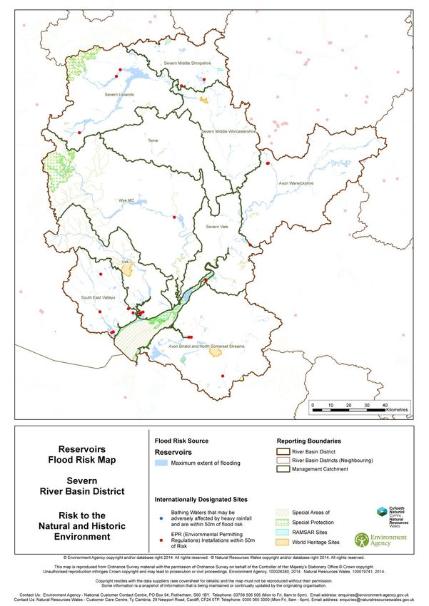
Contents
   Foreword .......................................................................................................................... v
   Format of the flood risk management plan ...................................................................... vi
   Contents ........................................................................................................................ viii
   Glossary and Abbreviations ............................................................................................ ix
Part A ................................................................................................................................... 1
   1.       What is flood risk and who manages it? ................................................................. 1
   2.       What is a Flood Risk Management Plan? ............................................................... 6
   3.       How has the plan been developed?...................................................................... 11
   4.       How to manage risk .............................................................................................. 16
   5.       Getting to know the Severn river basin district ...................................................... 20
   6.       Key flood risk issues in the Severn River Basin District ........................................ 29
   7.       Sub-areas in the Severn RBD .............................................................................. 51
   8.       Conclusions, objectives and measures to manage risk for the Severn RBD ........ 53
   9.       Implementing the plan .......................................................................................... 65

                                                                    viii
Glossary and Abbreviations
AONB               Area of Outstanding Natural Beauty
BAP                Biodiversity Action Plan
Catchment          The watershed of a surface water river system
CaBA               Catchment based approach: an approach to environmental planning that focuses
                   on local engagement and partnerships
CFMP               Catchment Flood Management Plan
Coastal Groups     Voluntary coastal defence groups made up of maritime district authorities and
                   other bodies with coastal defence responsibilities.
Cross Border       Set up under The Flood Risk (Cross Border Areas) Regulations 2012 (SI No.
Advisory Group     1102). A statutory group made up of representatives from SEPA, Environment
(CBAG)             Agency and local authorities within the cross border areas.
Cross Border       Those areas designated as ‘cross border’ under The Flood Risk (Cross Border
Areas              Areas) Regulations 2012 (SI No. 1102).
CWS                County Wildlife Site
DCLG               Department for Communities and Local Government
Defra              Department for Environment, Food and Rural Affairs
EA                 Environment Agency
EIA                Environmental Impact Assessment
EPR                Environmental Protection Regulations
EU                 European Union
FCERM              Flood and coastal erosion risk management
Floods Directive   The European Floods Directive (2007/60/EC) on the assessment and
                   management of flood risks.
Flood Risk Area    Areas where the risk of flooding from local flood risks is significant as designated
(FRA)              under the Flood Risk Regulations.
FRM                Flood Risk Management
FRMP               Flood Risk Management Plan – plan produced to deliver the requirements of the
                   Flood Risk Regulations.
Government         The term government is used within this report to refer to Defra (the Department
                   for Environment, Flood and Rural Affairs) and Welsh Government.
Groundwater        Occurs when water levels in the ground rise above the natural surface. Low-lying
flooding           areas underlain by permeable strata are particularly susceptible.
Ha                 Hectares
HLS                Higher Level (Environmental) Stewardship
HRA                Habitats Regulations Assessment: an assessment undertaken in relation to a site
                   designated under the Habitats and Birds Directives
Km                 Kilometres
LDF                Local Development Framework
LLFA               Lead Local Flood Authority
Local FRM          Local flood risk management strategy produced by LLFAs under the Flood and
Strategy           Water Management Act 2010.
Main river         A watercourse shown as such on the main river map, and for which the
                   Environment Agency and Natural Resources Wales has responsibilities and
                   powers
MSFW               Making Space for Water

National FCERM     National flood and coastal erosion risk management strategy: these are strategies
Strategy           prepared under the Flood and Water Management Act 2010, by the Environment
                   Agency for England and by Welsh Government for Wales.
Natural Resource   The taking care of (or management of) natural resources such as land, water, air,
Management         soil, plants and animals with a particular focus on how their management affects
                   the quality of life for both present and future generations.
NNR                National Nature Reserve

                                                ix
NRW                 Natural Resources Wales. The NRW took over the functions of the Environment
                    Agency in Wales on 1st April 2013.
Ordinary            All watercourses that are not designated Main River, and which are the
watercourses        responsibility of Local Authorities or, where they exist, Internal Drainage Boards.
(OW)

PFRA                Preliminary Flood Risk Assessment – these were required to be published by
                    December 2011 and were the first stage in delivering the Regulations.
PU                  Policy Unit

Ramsar              Wetlands of international importance designated under the Ramsar Convention

Reservoir           A natural or artificial lake where water is collected and stored until needed.
                    Reservoirs can be used for irrigation, recreation, providing water supply for
                    municipal needs, hydroelectric power or controlling water flow.
Risk management     Organisations that have a key role in flood and coastal erosion risk management
authorities         as defined by the Act. These are the Environment Agency, Natural Resources
(RMAs)              Wales, lead local flood authorities, district councils where there is no unitary
                    authority, internal drainage boards, water companies, and highways authorities.
RFCCs               Regional Flood and Coastal Committees
River Basin         These are the reporting units to the European Commission for the Water
District (RBD)      Framework Directive and the Floods Directive.

RBMP                River Basin Management Plan – plan required by the European Water
                    Framework Directive.
River flooding      Occurs when water levels in a channel overwhelms the capacity of the channel.

SAC                 Special Area of Conservation
SAM                 Scheduled Ancient Monument
SAMP                System Asset Management Plan
SEA                 Strategic Environmental Assessment
SFRA                Strategic Flood Risk Assessment
SMP                 Shoreline Management Plan
SPA                 Special Protection Area
SSSI                Site of Special Scientific Interest
SuDS                Sustainable Drainage Systems
Sewer flooding      Flooding caused by overloaded sewers or blockages or defects within the
                    sewerage network
Surface water       Flooding from rainwater (including snow and other precipitation) which has not
flooding            entered a watercourse, drainage system or public sewer.
SWMP                Surface Water Management Plan
UKCIP               United Kingdom Climate Impact Projections
Working with        Taking action to manage flood and coastal erosion risk by protecting, restoring
natural processes   and emulating the natural regulating function of catchments, rivers, floodplains
                    and coasts. An example of this is using land to temporarily store flood water away
                    from high risk areas.

                                                  x
Part A
1. What is flood risk and who
manages it?
The Flood and Water Management Act (2010) defines flooding as any case where land not
normally covered by water becomes covered by water. Flood risk is a combination of
two components: the chance (or probability/ likelihood) that a location will flood from any source or
type of flooding, and the associated impacts (or consequences) of the flooding. Flood risk
management is generally concerned with reducing harm which might take the form of property
damage or physical injury to people and wildlife. However, flooding can also have beneficial effects
too, in particular for wetland wildlife as well as some types of agriculture that are water dependent.
Figure 1.1: What is flood risk?
Risk Likelihood Impact
= x
Risk captures the severity of, or related consequences produced by, a flood event. Impacts can be
social, economic and environmental, for example the number of properties flooded and the level of
associated economic damages. The consequences of a flood depend on the level of exposure
and the vulnerability of those affected.
What is the likelihood of this happening and what does this mean?
Probability (or chance) is a measure of the likelihood that a defined event will occur. The probability
of a flood event is typically defined as the relative frequency of occurrence of that flood being
equalled or exceeded. Probability can be expressed as a fraction, percentage, a decimal or
description, and should always make reference to a time period. For example, flood risk
terminology may refer to ‘a 1 in 100 chance of flooding in any given year’ or ‘a 1% annual
probability of flooding’. Both of these expressions refer to the same likelihood of flooding.
Assessing impacts of flooding prior to an event usually involves estimating the potential impact of
flooding on people, property and the environment. The theoretical probability of flooding is
illustrated by the Environment Agency and Natural Resources Wales Flood Maps which show flood
risk from rivers and the sea, surface water and reservoirs. Flood models which are the basis for
the flood maps use uniform rainfall scenarios (the same amount of rainfall falling across the
country at the same time), whereas in reality rainfall rates vary greatly from one area to another.
It is not possible to prevent all flooding, but there are a variety of actions that can be taken to
manage flood risk and the impacts of flooding on communities. Flood risk managers must identify
all potential options to manage flood risk and balance the needs of communities, the economy and
the environment. Risk management authorities should work in partnership with each other and
communities to manage flood risk, ensuring that communities understand these risks, are involved
in the decision making process, and can actively prepare for the risks. By working together risk
management authorities should actively seek opportunities to coordinate risk management,
encourage partnership funding and deliver multiple benefits.
1 of 67Roles and responsibilities
Tables 1.1 and 1.2 show the RMAs involved in flood risk management in England and Wales and
their roles and responsibilities.
Table 1.1: Summary of responsibilities for risk management authorities
Flood Source EA / NRW LLFAs District Water Highways Internal
Company Authority Drainage
Boards²
Strategic overview
for all sources of
flooding & coastal
erosion
Main River
The Sea
Surface Water
Surface Water (on
or coming from
the Highway)
Sewer Flooding
Ordinary
Watercourse
Groundwater
Reservoirs * * * * * *
*For reservoirs with a capacity of 25,000 cubic metres or more
²As of 1 April 2015 in Wales the 3 Internal Drainage Districts that were operated by independent boards were
incorporated into NRW in April 2015.
Table 1.2: Roles and responsibilities of risk management authorities and others involved in
managing flood risk
Organisation Roles and Responsibilities
Environment Agency The Environment Agency has a strategic overview of all sources of flooding
and coastal erosion (rivers, the sea, groundwater, reservoirs and surface
water). It has permissive powers to manage flood risk from ‘main rivers’, the
sea and reservoirs. The Environment Agency can use enforcement powers
to require landowners to take action to minimise flood risk to others.
Natural Resources Permissive powers to manage flood risk from ‘main rivers’, the sea and
Wales reservoirs. Can use enforcement powers to require landowners to take
action to minimise flood risk to others.
LLFAs Upper tier local council or unitary council. Permissive powers to manage
flood risk from surface water, ‘ordinary watercourses’ (non-main rivers) and
groundwater. Enforcement powers are similar to Environment Agency and
Natural Resources Wales. Upper tier councils also manage highways.
Water Companies Water companies manage the sewerage and water supply networks and
any flood risk arising from them. Also manage flood risk to any critical
infrastructure, such as water treatment plants and pumping stations.
District Council (only in By agreement with the upper tier Lead Local Flood Authority, the District
England) Council may do some work to manage flood risk. District Councils are the
Local Planning Authority.
Community Council By agreement with the upper tier Lead Local Flood Authority, the
(only in Wales) Community Council may do some work to manage flood risk.
2 of 67Organisation Roles and Responsibilities
Internal Drainage Each Internal Drainage Board is a local public authority established in areas
Boards of special drainage need in England and Wales. They have permissive
powers to manage water levels within respective drainage districts. Internal
Drainage Boards undertake works to reduce flood risk to people and
property and manage water levels to meet local needs. In Wales the 3
Internal Drainage Districts that were operated by independent Boards were
incorporated into NRW in April 2015.
Maritime District Council As District Councils, but also manage coastal erosion. As many coastal
defences protect against both erosion and flooding from the sea, these
Councils often do both in urban areas.
Navigation Authorities The navigation network throughout the RBD is managed by a number of
agencies, including Environment Agency, NRW, Canal and River Trust
(CRT), the Avon Navigation Trust, Bristol Port Company and Bristol City
Council. Although not a designated RMA, CRT manages its network in a
way that minimises risk of flooding.
Highways England, Highways England, NWTRA & SWTRA look after the motorways and major
South Wales Trunk A roads focussing on the most important national routes, while councils
Road Agency manage the roads serving local communities. Having information about the
(SWTRA), condition of drainage assets they hold a Drainage Data Management
North Wales Trunk System (also known as HADDMS) to identify flooding issues and places at
Road Agency (NWTRA) particular risk, including private property, supporting a risk based
programme of drainage renewal works.
Riparian Landowner The owner of land next to a watercourse usually owns the land to the
middle of the river (unless property deeds show otherwise). This ‘riparian
landowner’ is responsible for maintaining the watercourse to allow free flow.
Individual property Individual owners have primary responsibility for safeguarding their land
owners and property from flooding. There is no legal right to be provided with
protection from flooding or the effects of flooding.
Communities Individuals at risk from flooding, or having flooded, are encouraged to form
a Flood Action Group or other Community Group as a focus for
understanding the issues, considering improvement options and
implementing solutions.
Non- RMA owners of Features and structures that have been designated as a flood defence
flood defences cannot be altered, removed or replaced without the consent of the
responsible authority.
Reservoir owners In addition to their general duty of care for the public under common law,
the owners of reservoirs with an above ground capacity of 25,000 cubic
metres or more have a legal duty to have their reservoirs supervised and
inspected regularly by experts; in order to prevent dam failures and the
dangerous flooding that could result. Reservoir owners could fall into any of
the above categories listed in the table.
Existing flood management schemes and properties protected
Risk Management Authorities work in partnership with each other and communities to manage
flood risk. The Flood Risk Management Plan sets out the current and proposed measures to
manage flood risk across the Severn RBD. However, RMAs have been undertaking a range of
activities to manage flood risk for many years. Details of these activities can be found in Section 6.
In some parts of the Severn RBD flood risk management schemes are in place to reduce flood risk.
The Environment Agency Flood Map for Planning and NRW Flood Risk Map shows the flood
defences that protect against fluvial and tidal floods. This information was used to produce an
overview of the flood defences within the Severn RBD. The Severn RBD contains a total of 3600
structures. The raised defences have a combined length of 390 km.
Some of the communities recently benefitting from flood management schemes are listed below;
3 of 67• Riverside, Newport, Gwent – sheet piling and masonry wall, completed 2011. Protects
appropriately 400 properties
• Maes-Y-Felin, Rhondda Cynon Taf – earth embankment and masonry wall, completed
2008. Protects approximately 80 properties.
• Rhymney Bridge, Cardiff – improvements to flood wall, completed 2014. Protects
approximately 30 industrial and retail units.
• Coleham Head, Shrewsbury – masonry wall and demountable defence, completed 2011.
Protects approximately 80 properties.
• Broom, River Arrow, Warwickshire – flood walls and earth embankments, completed
2012. Protects approximately 70 properties.
• Marcliff, River Avon, Warwickshire – flood walls, earth embankments, culvert
improvement & watercourse realignment, completed 2012. Protects approximately 20
properties.
• Hereford – River Wye, masonry wall and demountable defences, completed 2008. Protects
approximately 200 properties.
• Upton on Severn, Worcestershire – earth embankment and masonry wall, completed
2011. Protects approximately 65 properties.
• Kempsey, Worcestershire – earth embankment and pumping station, completed 2011.
Protects approximately 70 properties.
• Uckinghall, Worcestershire – earth embankment and masonry wall, completed 2010.
Protects approximately 30 properties.
• Pershore, Worcestershire – earth embankment and masonry wall, completed 2010.
Protects approximately 60 properties.
• Horsbere Brook, Gloucestershire – flood storage area, completed 2011. Protects
approximately 350 properties.
• Daniels Brook, Gloucestershire – channel works, completed 2011. Protects
approximately 200 properties.
• Lydney, Gloucestershire – masonry wall, completed 2012. Protects approximately 60
properties.
• Weston-super-Mare – Seafront Enhancement Scheme completed 2010. Protects
approximately 4,500 properties. North Somerset Council lead.
• Bristol, City Centre – Floating Harbour Tidal Flood Gate Refurbishment completed 2010.
Protects approximately 400 properties. Bristol City Council lead.
• Pill, Bristol – Tidal Defence Scheme completed 2010. Protects approximately 100
properties.
Flood risk information
The Severn Flood Risk Management Plan covers flood risk from rivers and the sea, reservoirs and
selected areas of surface water flood risk (Bristol Flood Risk Area only – as identified in
Preliminary Flood Risk Assessment (PFRA)). The following section outlines flood risk
classifications for the various sources.
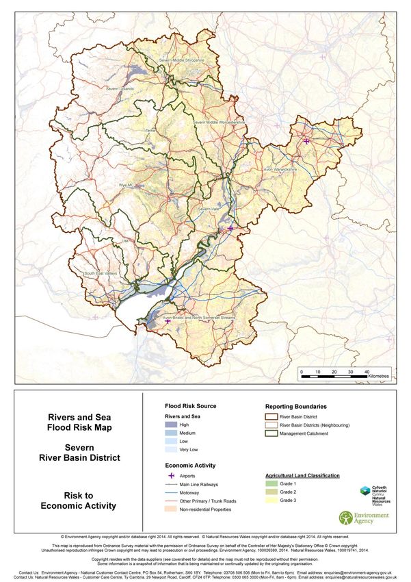
Flooding from river and the sea
National Flood Risk Assessment (NaFRA) is an assessment of flood risk for England and Wales
produced using local data and expertise. It shows the chance of flooding from rivers and the sea
(both along the open coast and tidal estuaries). The data is presented in flood risk likelihood
categories, which indicate the chance of flooding in any given year.
High - greater than or equal to 1 in 30 (3.3%) chance in any given year
Medium - less than 1 in 30 (3.3%) but greater than or equal to 1 in 100 (1%) chance in any given
year
4 of 67Low - less than 1 in 100 (1%) but greater than or equal to 1 in 1,000 (0.1%) chance in any given
year
Very Low - these properties may have a greater than 1 in 1,000 chance of flooding in any given
year if defences weren’t present. However, in reality the chance of flooding is reduced below a 1 in
1,000 chance by defences, which NaFRA analysis includes.
The computer model used to produce NaFRA results estimates the likelihood of flooding from
rivers and the sea, taking into account defences and the chance that they can fail or be
overtopped. The results, which are presented in maps, databases and excel spreadsheets, can be
used in conjunction with receptor data (number and type of properties and infrastructure) to
estimate the consequences and economic damage associated with flooding from rivers and the
sea.
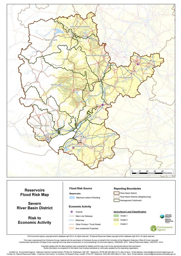
Flooding from reservoirs
Reservoir flood risk maps show the area that could be flooded if a large reservoir were to fail and
release the water it holds. This is a worst case scenario. A large reservoir is one that holds over
25,000 cubic metres.
Flooding from surface water
The maps and statistics contained in this plan are based on the Updated Flood Map for Surface
Water (uFMfSW) published in December 2013.The uFMfSW assesses a range of flooding
scenarios (annual probability of flooding is shown in brackets):
High -1 in 30 (3.3%)
Medium - 1 in 100 (1%)
Low - 1 in 1000 (0.1%)
The uFMfSW replaced the ‘Areas Susceptible to Surface Water Flooding’ maps produced in 2010
by the Environment Agency. For further information about how the statistics relating to surface
water are generated please see Annex 4.
5 of 672. What is a Flood Risk Management
Plan?
Flood risk management plans highlight the hazards and risks from rivers, the sea, surface water,
groundwater and reservoirs and set out how RMAs will work together with communities to manage
flood risk. Some water companies have provided measures related to sewer flooding, and it is
anticipated that future cycles of the FRMP will include more information on sewer flooding.
What is the FRMP for?
Flood Risk Management Plans (FRMPs) are produced every 6 years and describe the sources and
risks of flooding within a river basin district and catchment. They also include information on how
risk management authorities (RMAs) plan to work together with communities and businesses to
manage and reduce flood risk. Over the 6 year planning cycle the FRMP will help promote a
greater awareness and understanding of the risks of flooding, particularly in those communities at
high risk, and encourage and enable householders, businesses and communities to take action to
manage the risks. FRMPs along with River Basin Management Plans (RBMPs) help all those
involved in managing water to make decisions that are best for people and the environment.
Why are FRMPs being prepared?
This is the first cycle of implementing the Flood Risk Regulations 2009. As a result of this
legislation, LLFAs must prepare FRMPs in Flood Risk Areas, where the risk of flooding from local
flood risks is significant (as identified in Preliminary Flood Risk Assessments (PFRAs)) for instance
from surface water, groundwater and ordinary watercourses. Natural Resources Wales and the
Environment Agency are required to prepare FRMPs for all of Wales and England covering
flooding from main rivers, the sea and reservoirs. Further information on what is a flood risk
management plan can be found on the GOV.UK website.
Flood risk and coastal erosion management activities require careful planning to ensure that
appropriate, sustainable options are selected and that they are implemented properly. Actions
should be planned effectively, for the long-term, and provide a clear picture of what will be done to
manage risk and provide multiple benefits. This may include, for example, linking with other plans
such as river basin management plans (RBMPs) and supporting biodiversity, habitat creation or
improving water quality. Natural Resources Wales, the Environment Agency and contributing
LLFAs are developing FRMPs by drawing existing information together and building on existing
Flood and Coastal Erosion Risk Management plans such as: Catchment Flood Management
Plans (CFMPs), Shoreline Management Plans (SMPs) and Local Flood Risk Management
Strategies (LFRMS) (see Figure 2.1).
6 of 67Figure 2.1: FRMPs and their relationship to other planning initiatives (taken from the National FCERM Strategies for England and Wales)
7 of 67What the plan does
The FRMP will help deliver the requirements of the National Flood and Coastal Erosion Risk
Management Strategy in England and the Welsh Government’s National Flood and Coastal
Erosion Risk Management Strategy in Wales by setting out the measures to manage flood risk now
and in the future. The FRMP will:
- Help develop and promote a better understanding of flood and coastal erosion risk
- Provide information about the economic and environmental benefits to inform decision
makers
- Identify communities with the highest risk of flooding so that investment can be targeted at
those in most need.
Measures in FRMPs do not all have secured funding and are not guaranteed to be implemented.
Money is allocated to RMA measures based on current Government policy that gives the highest
priority to the areas at highest risk. The funding for flooding is devolved so RMA measures are
funded by DEFRA in England, in Wales they are funded by Welsh Government.
What types of flood risk are included in the FRMP?
The FRMP covers the flood risks that the RMAs are responsible for (see table 1.2 for roles and
responsibilities).
The Environment Agency and Natural Resources Wales have worked in partnership with other
RMAs to pool the information needed to develop the FRMP. Some RMAs have a statutory duty to
produce a FRMP as they have areas designated as Flood Risk Areas (see table 2.1: LLFAs
contributing to this FRMP and table 2.3: LLFAs and Flood Risk Areas in separate FRMPs). Other
LLFAs have included information on a voluntarily basis. All lead local flood authorities were invited
to contribute to this plan, with those listed below in table 2.2 choosing to do so. It is hoped that
other RMAs will contribute to future cycles of the FRMP, which will allow all sources of flooding to
be more comprehensively captured.
Some water companies have provided measures relating to sewer flooding in this FRMP and the
intention is to include more information relating to sewer flooding in future cycles of the FRMP.
Areas of significant ‘local flood risk’ were identified from historic flood records and analysis of
potential future flooding from surface water, groundwater and ordinary watercourses. In England
‘Flood Risk Areas’ were designated on the basis of there being at least 30,000 people in properties
at risk of flooding, or 150 critical services (for example - schools, hospitals, nursing homes, power
and water services). In Wales, the threshold agreed by Ministers for ‘Flood Risk Areas’ is 5,000
people at risk of flooding. A lower threshold was selected in Wales to reflect the nature of risks in
Wales including the smaller size settlements and the risks in the South Wales valleys.
The Flood Risk Areas were determined by locally agreed surface water flood maps produced in
2010 by the Environment Agency and supplemented with data from Lead Local Flood Authorities
where available.
In the Welsh part of the RBD there were six local authorities that have Flood Risk Areas and are
required to produce FRMPs. For this cycle of the FRMP production it was decided that the local
authorities would produce their FRMP separately. The remaining local authorities in Wales are
voluntarily producing their own separate FRMPs.
8 of 67Table 2.1: LLFAs contributing to this FRMP
Flood Risk Area and Voluntary Information Lead Local Flood Authorities
Bristol Flood Risk Area Bristol City Council
North Somerset Council
Includes voluntary information from outside
Bath and North East Somerset
Flood Risk Area from all councils
South Gloucestershire Council
West Midlands The following LLFA’s within the Severn RBD bordering
the Severn FRMP have fed into the Humber FRMP:
Wolverhampton City Council
Dudley Metropolitan Borough Council
Sandwell Metropolitan Borough Council
Table 2.2: Additional RMAs who have voluntarily provided information for the Severn FRMP
Flood Risk Area and Voluntary Information Lead Local Flood Authorities
Lead Local Flood Authorities Somerset County Council
Table 2.3: LLFAs and Flood Risk Areas in separate FRMPs
Flood Risk Area and Voluntary Information Lead Local Flood Authorities
South Wales Flood Risk Areas Blaenau Gwent County Borough Council (statutory)
Cardiff City Council (statutory)
Caerphilly County Borough Council (statutory)
Rhondda Cynon Taff County Borough Council
(statutory)
Merthyr Tydfil County Borough Council (statutory)
Torfaen County Borough Council (statutory)
Voluntary Newport County Borough Council (voluntary)
Monmouth County Council (voluntary)
Powys County Council (voluntary)
Vale of Glamorgan County Borough Council (voluntary)
Find out more about flood risk management:
Link to FRMP guidance in England
National Flood and Coastal Erosion Risk Management Strategy for England
National Flood and Coastal Erosion Risk Management Strategy for Wales
Flood and Coastal Change
Interactive flood maps
9 of 67Figure 2.2: Sources of flood risk information included in this FRMP
10 of 673. How has the plan been developed?
The approach to developing FRMPs
In 2013 the Government agreed that the preferred approach to developing FRMPs would be for the
Environment Agency and Natural Resources Wales to work in partnership with other RMAs, in
particular LLFAs, to pool information to develop an overall plan for managing all sources of flood
risk and coastal erosion. In preparing this FRMP, RMAs have built on relevant information from
existing work (see Figure 2.1 and Table 3.1). Of particular importance are the Local Flood Risk
Management Strategies developed by all LLFAs. In drawing measures together, RMAs have
revisited priorities and ensured that there is a shared understanding of the risks and how best they
can be managed.
The Environment Agency and Natural Resources Wales are co-ordinating the development of this
FRMP with the RBMP so that there is an integrated approach to overall water management for the
benefit of people, the environment and the economy.
Table 3.1 shows the sources of FRMP information. These plans remain active. In England the
future need for Catchment Flood Management Plans (CFMPs) as the strategic plan for river and
estuary flooding is being reviewed in 2015 and 2016. As with all of the plans listed in Table 3.1, all
relevant actions have been brought together in FRMPs. Irrespective of the review, the actions will
be being taken forward by the FRMP. The CFMP long term policies have not been carried forward
in England but relevant CFMP objectives have been brought into the FRMP.
Find out more:
Interactive flood maps
River Basin District Maps
Table 3.1: Sources of FRMP information according to flood risk
Flood risk Existing plans and FRMP information
Flooding from main rivers Catchment Flood Management Plans (CFMPs):
Eastern Valleys, Wye and Usk, Severn Tidal
Tributaries, River Severn, Bristol Avon, Taff & Ely,
North & Mid Somerset
Fluvial Severn Flood Risk Management Strategy
Flooding from the sea and along estuaries, Shoreline Management Plans (SMPs):
coastal erosion Anchor Head to Lavernock Point
Estuary Management Plans:
Severn Estuary Flood Risk Management Strategy
Flooding from reservoirs Reservoir Plans and Reservoir Flood Risk Maps:
Severn River Basin District
Flooding from surface water, groundwater Local Flood Risk Management Strategies
and ordinary watercourses (LFRMSs):
Bristol City Council, North Somerset Council, Bath &
North East Somerset, South Gloucestershire Council
Surface Water Management Plans (SWMPs):
Bristol City Council
11 of 67Consultation and engagement
Consultation and engagement on this FRMP helped improve, inform and shape the plan. National
public consultation took place between October 2014 and January 2015.
Blaenau Gwent County Borough Council, Cardiff City Council, Caerphilly County Borough Council,
Rhondda Cynon Taff County Borough Council, Merthyr Tydfil County Borough Council and Torfaen
County Borough Council also have a legal responsibility to consult on the FRMP they are
producing and have done so separately.
Environment Agency consultation document 12i –
https://www.gov.uk/government/consultations/update-to-the-draft-river-basin-management-plans
NRW consultation document – http://naturalresources.wales/media/674720/dfrmp-consultation-
response-update.pdf
Objective setting
This plan covers areas in England where the Environment Agency is the responsible authority for
flood risk management (with regard to main rivers, the sea and reservoirs) and areas in Wales
where Natural Resources Wales is the responsible authority for flood risk management (with
regard to main rivers, sea and reservoirs). Where the plan crosses the national boundary,
agreements and arrangements are in place to enable both organisations to develop the plan jointly
and ensure that impacts either side of the boundary are understood and agreed by each authority.
FRMPs contain objectives for managing flood risk. These objectives are a common set of goals
agreed by risk management authorities and they state the main ways in which work is directed to
make a difference and reduce flood risk. They cover people, the economy and the environment.
The objectives are split into the 3 categories to help demonstrate the balance of objectives across
the plans but the categories aren’t assigned a weighting in the FRMP. Objectives are used to plan
and prioritise investment programmes to target investment in the most at risk communities.
Objectives are prioritised at an England-wide level and Wales-wide level. This takes into account
the risk, but also considers other factors such as cost benefits, the level of investment to date and
other aspects such as the potential for external funding opportunities.
The Severn FRMP contains an overarching set of objectives for the river basin district as a whole.
Below this are separate sets of objectives for the Welsh part of the Severn and English part of the
Severn. In Wales there are a set of objectives, listed in part B, that apply to all the catchments in
Wales. These objectives ensure a consistency of approach in Wales and link to both the National
FCERM Strategy and the measures as indicated in the tables at the catchment level. In England
there is a set of objectives that relate to the whole of the English Severn and there are also
separate English catchment objectives, which can differ from one area to the next and allow RMAs
to focus on locally important improvements. All levels of objectives are linked. The English
measures tables in the appendices show which category of objective relates to each measure.
12 of 67Figure 3.1: Levels of objectives within the Severn flood risk management plan.
Management of flood and coastal erosion risk in England and Wales is driven by the National
Strategies for Flood and Coastal Erosion Risk Management for England and Wales, respectively.
These strategies provide the framework for flood and coastal erosion risk management work in the
RBD. The overarching principles of the strategies were used to determine objectives for the RBD
that consider people, the environment and economic activity.
The Severn RBD FRMP catchment objectives are based on those set in the Catchment Flood
Management Plans (CFMPs) and the Shoreline Management Plans (SMP2s) previously developed
for the whole of England and Wales in partnership with other RMAs, and Local Flood Risk
Management Strategies prepared by contributing LLFAs to meet the requirements of the Flood &
Water Management Act 2010.
Where objectives are specific to only England or Wales, they are captured in the England or Wales
only sections.
How each authority delivers against their FRMP objectives differs in England and Wales.
Wales
In order to deliver measures to meet the FRMP objectives, Natural Resources Wales takes a risk
based community approach to prioritise where to best direct investment. This is informed by the
strategic framework provided by CFMPs and SMPs. The strategic framework set by these plans
enable Natural Resources Wales to make short term decisions to manage present day risk whilst
also considering the longer term prediction of risk (for further information on CFMPs and SMPs
please refer to Annex 3). The risk based community approach of present day risk is done through
the Natural Resources Wales Communities at Risk Register. This is a tool that considers a number
of factors to give an indication of where the most vulnerable communities at risk of flooding from
main rivers and the sea are located across Wales. This is then used to plan and prioritise the
Natural Resources Wales investment programme to target investment in the most at risk
13 of 67communities. Prioritisation is then done at a Wales-wide level and takes into account the risk
calculation from the Communities at Risk Register but also considers other factors such as the
Benefit: Cost appraisal, level of investment to date and other aspects such as the potential for
external funding opportunities. There is also a facet of Natural Resources Wales work which is
reactive to severe weather events, where severe damage may have occurred, leading to the need
for emergency works.
All major flood alleviation schemes in Wales undergo appraisal work to assess options and to
understand the costs and benefits of progressing work. This is done in accordance with Treasury
guidance.
England
Measures to meet the objectives include actions taken forward from the SMP2 (except in the small
number of locations where these now differ following development of more up to date strategies),
incomplete actions from the CFMP where still relevant, from existing flood risk management
strategies and the 6 year capital investment plan. Over time the aim is to also include actions from
more local flood risk management strategies produced by LLFAs for their areas. This first plan
includes a number of ongoing, agreed and newly proposed actions at the community level. Over
time, the Environment Agency shall be considering further community level actions within the RDB.
The aspiration is to add these in future cycles of the plan.
Funding to RMAs to manage flood risk from watercourses, surface run-off and groundwater is
mainly provided by Defra as flood and coastal erosion risk management grant in aid (FCRM GiA).
Highways authorities and water authorities can apply for GiA funding for projects to reduce flood
risk which wouldn’t ordinarily be within their remit. Regional Flood and Coastal Committees can
also raise local levy funding for local priority projects in partnership with others.
Government promotes nationally consistent approaches to assessing and managing flood and
coastal erosion risk and RMAs prioritise public investment in flood and coastal risk management
works according to Defra policy and Environment Agency guidance.
The Environment Agency has a role in allocating FCRM GiA and local levy funding to RMAs. Risk
Management Authorities bid for the funding through medium term planning and projects are
selected on the basis of the outcomes delivered, costs and benefits. Taking a risk-based
management approach, resources are targeted to ensure that public money is spent on the works
that provide the greatest benefits to society, and that this money is spent efficiently and effectively.
Under Defra’s partnership funding approach, government funding towards schemes is based on
the numbers of households protected, the damages being prevented and other benefits that would
be delivered. For schemes to proceed where they are not fully funded by government either the
costs would need to be reduced or the remainder of the funding provided through local
contributions. The approach helps achieve the best value for public money and encourages others
to contribute where it is in their interests to do so.
Strategic Environmental Assessment and Habitats Regulations
A Strategic Environmental Assessment (SEA) was undertaken to consider the significant
environmental effects of the FRMP. Natural England, Historic England, Natural Resources Wales,
Cadw and the Marine Management Organisation were consulted on the scope of the proposed
assessment in December 2013, and the environmental report sets out the results of the SEA. The
report describes the environmental effects that are significant within the RBD and identifies
measures to mitigate any adverse effects. Opportunities to improve the environment are also
considered in order to deliver greater environmental benefits where possible. The SEA identified
the potential environmental effects of flood risk management measures in the FRMP. The focus
was on the combined effects of the programme of protection measures across a catchment or
flood risk area, rather than individual measures at specific locations.
A similar approach has been used for the RBMP and FRMP which allows us to compare the
environmental effects directly and consider the interaction between the two plans. Indicators are
14 of 67also set out that will be used to monitor the effect of the plan on significant environmental
receptors, taking advantage of existing monitoring that is already carried out by the Environment
Agency, Natural Resources Wales and others.
A Habitats Regulations assessment has been carried out on the FRMP to consider whether the
plan affects designated sites (Special Areas of Conservation, Special Protection Areas and
Ramsar sites). The assessment concluded that the plan is not likely to have a significant effect on
European Designated Sites.
For information on the Severn FRMP contribution to broader benefits and links with the Severn
River Basin Management Plan see Section 8.
How FRMPs have been co-ordinated with river basin management
planning
The Environment Agency and Natural Resources Wales lead on the development of FRMPs and
RBMPs. The aims are to co-ordinate work effectively, and support others to do the same, so that
more can be done for the environment when flooding is managed. Information on how consultation
has shaped the plans was published jointly with RBMPs. The FRMP measures of the plans are
linked to RBMP and Water Framework Directive objectives, so that the Environment Agency and
Natural Resources Wales know where flood risk projects contribute to environment outcomes.
How the FRMP contributes to wider benefits is covered in Section 8 of this plan.
Co-ordinating with the RBMP:
Severn RBMP
15 of 674. How to manage risk
Involving communities leads to more effective flood and coastal erosion risk management. RMAs
will continue to work with communities and other stakeholders to manage risk by:
assessing the sources of flood risk and drawing conclusions about the risks;
setting out what RMAs are trying to achieve and establishing risk management objectives;
determining the best approach to achieving the objectives by identifying the right measures
and prioritising them.
The conclusions, objectives and proposed measures are set out within this FRMP. During the 6
year planning cycle set out in the Flood Risk Regulations (2009) RMAs will work with partners and
interested parties to:
seek to secure the necessary funding, including from partners;
implement the measures, with clarity on what each organisation is accountable for;
monitor and review how the plan works.
RMAs will monitor, and report annually, on progress in implementing the measures set out in the
FRMP. RMAs will continue to work in partnership, ensuring that they can maintain a forward look of
prioritised proposals for managing flood risk. The next review of the FRMP under the Flood Risk
Regulations will be completed by 2021.
National flood and coastal erosion risk management strategy for
Wales
The Welsh Government National Flood and Coastal Erosion Risk Management Strategy provides
the framework for flood and coastal erosion risk management in Wales. The framework is centred
around four key objectives and the measures to meet those objectives.
Reducing the consequences for individuals, communities, businesses and the environment
from flooding and coastal erosion;
Raising awareness of and engaging people in the response to flood and coastal erosion
risk;
Providing an effective and sustained response to flood and coastal erosion events;
Prioritising investment in the most at risk communities.
Natural Resources Wales plans and implements flood risk management work for which Natural
Resources Wales are responsible within the framework set by the National Flood and Coastal
Erosion Risk Management Strategy.
In order to deliver the measures from the National FCERM Strategy, Natural Resources Wales
takes a risk based community approach to prioritise where to best direct investment. This is
informed by the strategic framework provided by Catchment Flood Management Plans and
Shoreline Management Plans. The strategic framework set by these plans enable us to make
short term decisions to manage present day risk whilst also considering the longer term projection
of risk.
National flood and coastal erosion risk management strategy for
England
The national flood and coastal erosion risk management strategy for England (2011) provides the
overarching framework for future action by all RMAs to tackle flooding and coastal erosion risk in
England. The overall aim of the strategy is to ensure the risk of flooding and coastal erosion is
16 of 67properly managed by using the full range of options in a co-ordinated way. It encourages more
effective risk management by enabling people, communities, business, infrastructure operators
and the public sector to work together to:
ensure a clear understanding of the risks of flooding and coastal erosion, nationally and
locally, so that investment in risk management can be prioritised more effectively;
set out clear and consistent plans for risk management so that communities and
businesses can make informed decisions about the management of the remaining risk;
manage flood and coastal erosion risks in an appropriate way, taking account of the needs
of communities and the environment;
ensure that emergency plans and responses to flood incidents are effective and that
communities are able to respond effectively to flood forecasts, warnings and advice;
help communities to recover more quickly and effectively after incidents.
The strategy recognises that difficult decisions have to be taken on where activities can and can’t
be carried out at both national and local levels. As such, six guiding principles have been identified
to help guide these decisions and the processes by which they are taken. These guiding principles
are:
1. Community focus and partnership working
2. A catchment and coastal “cell” based approach
3. Sustainability
4. Proportionate, risk-based approaches
5. Multiple benefits
6. Beneficiaries should be encouraged to invest in risk management.
In support of the guiding principles for delivering multiple benefits the national strategy advocates:
Flood risk management solutions should enhance the environment;
FCRM should avoid damaging the environment, including the historic environment;
FCRM should wherever possible seek to work with natural processes;
FCRM should always seek to provide environmental benefit as required by the Habitats,
Birds and Water Framework Directives.
This FRMP has been developed to meet the legal requirements of the Flood Risk Regulations. In
doing so, the national flood and coastal erosion risk management strategy for England has also
been taken into account, in particular its guiding principles.
Measures for managing risk
There are different approaches to managing flood and coastal erosion risk – these are known as
measures and are described below:
The text below sets out how measures are displayed in this document.
Preventing: by avoiding putting people or the environment at risk of flooding, for example, one
way of preventing risks arising would be by not building homes in areas that can be flooded.
Preparing: by taking actions that prepare people for flooding, for example, by improving
awareness of flood risk, or by providing warning and forecasting for floods so that people can take
precautions to safeguard their valuables.
Protecting: by protecting people from the risk of flooding. For example, by the maintenance or
refurbishment of existing defences, building new defences or incorporating property resilience
measures such as using waterproof boards over doors and airbricks to reduce the damaged
caused by flood water.
Recovery and review: by learning from when flooding happens and how to recover from it, for
example, by improving the availability of recovery services such as providing temporary
accommodation, after flooding has occurred. There will be a disproportionately low amount of
actions in this category as recovery and review can only occur in the aftermath of floods.
17 of 67You can also read