Coastal Assets Activity Management Plan 2018 - Tasman District ...
←
→
Page content transcription
If your browser does not render page correctly, please read the page content below
Coastal Assets
Activity Management Plan
2018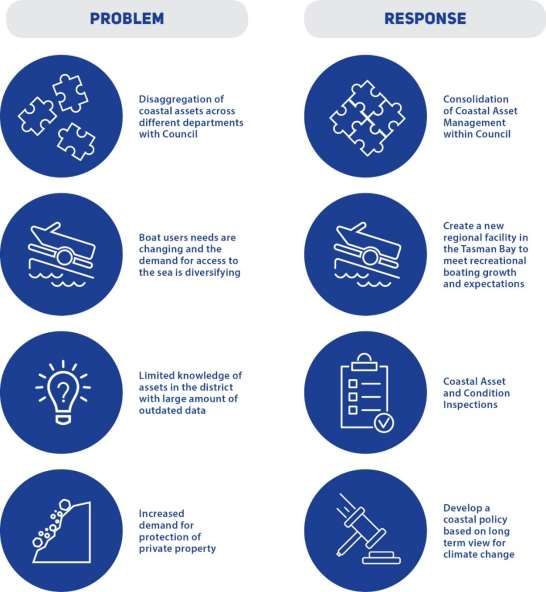
Quality Assurance Statement
                               Version:                           1July 2018

 Tasman District Council       Status:                            Final

 189 Queen Street
 Private Bag 4                 Project Manager:                   Jenna Neame

 Richmond 7050
 Telephone: (03) 543 8400      Prepared by:
 Fax: (03) 5439524             AMP Author                         Drew Bryant

                               Approved for issue by:
                               Engineering Manager                Richard Kirby

PAGE 2                                                  COASTAL ASSETS ACTIVITY MANAGEMENT PLAN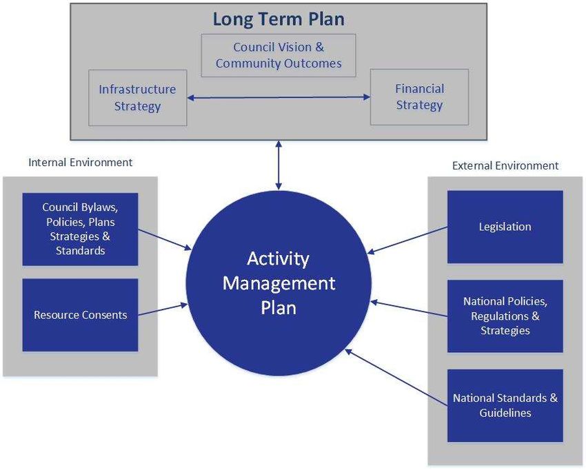
Contents
1      Executive Summary ....................................................................................................................... 4
2      Introduction ..................................................................................................................................... 7
3      Strategic Direction ........................................................................................................................ 23
4      Key Linkages ................................................................................................................................ 27
5      Levels of Service .......................................................................................................................... 30
6      Our Customers and Stakeholders ................................................................................................ 33
7      Current and Future Demand ........................................................................................................ 35
8      Lifecycle Management ................................................................................................................. 38
9      Financials ..................................................................................................................................... 46
10     Sustainability ................................................................................................................................ 56
11     Risk Management and Assumptions............................................................................................ 60
12     Asset Management Processes and Practices ............................................................................. 65
13     Improvement Planning ................................................................................................................. 72
Appendix A: Detailed Operating Budgets .............................................................................................. 77
Appendix B: Detailed Capital Budgets .................................................................................................. 79

PAGE 3                                                                                 COASTAL ASSETS ACTIVITY MANAGEMENT PLAN
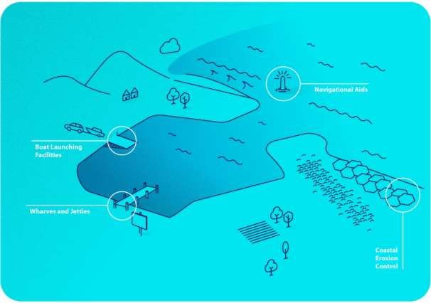
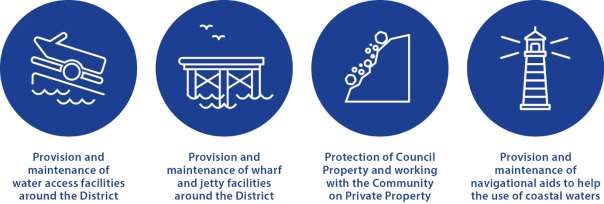
1        Executive Summary
The sea and people using it has shaped the District in the past and will continue to do so well into the
future. The coastal environment, is a major attraction for residents and visitors alike, and generates
significant benefits for the District.

1.1      What We Do
The following graphics provide an overview of this activity.

PAGE 4                                                         COASTAL ASSETS ACTIVITY MANAGEMENT PLAN
1.2      Why We Do It
    Council aims to ensure access to the sea can be enjoyed by all whilst managing the effects of the sea on
                                                  property.

1.3      Levels of Service
                                                                                  “Our coastal assets are
 “Our communities are protected          “Our structures are safe for the       maintained to an appropriate
   from natural hazard events.”                   public to use.”                  level that satisfies the
                                                                                community’s expectations.”

A new levels of service measures have been added to ensure that the safety of public using the assets are
considered. The levels of service are not changing, but added the new level of service may improve the overall
condition of the assets.
1.4      Key Issues

PAGE 5                                                          COASTAL ASSETS ACTIVITY MANAGEMENT PLAN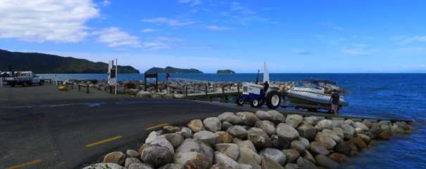
1.5 Operational Programme The operational programme has been developed to maintain a good level of service to meet targets. Addition funds will be spent on asset condition inspections. 1.6 Capital Programme Council has developed a capital programme of works that shows the key programmes of capital improvements expenditure. 1.7 Key Changes Key changes for the management of this activity since the 2015 Activity Management Plan are summarised below. 1.8 Key Risks and Assumptions There are factors outside of Council’s control that can change having an impact on Council’s ability to do what it planned. Sometimes the impact can be significant. There is always uncertainty in any planning process but the key to good quality planning is to make clear assumptions to help address this uncertainty. This section sets out the key risks and assumptions that relate to this activity: Sea level rise or climate change have significant impact on this activity. This AMP assumes there will not significantly step change in natural hazard events or sea level over the next three years. Improvements in the coastal assets knowledge will not require significant investment in renewal and maintenance outside of the normal historic budgets. PAGE 6 COASTAL ASSETS ACTIVITY MANAGEMENT PLAN
2 Introduction The purpose of this activity management plan (AMP) is to outline and to summarise in one place, Council’s strategic management and long term approach for the provision and maintenance of its this activity. 2.1 Rationale for Council Involvement Coastal assets provide many public benefits including provision of access to the coastal environment and coastal protection structures. Council is responsible as a regional authority to manage the coastal assets that it owns or that have no other identifiable owner. It is therefore necessary that Council undertakes the planning, implementation and maintenance of coastal assets within the District in accordance with its respective legislation requirements and responsibilities. 2.2 Description of Assets & Services Key coastal assets are: wharves; jetties; coastal protection; boat ramps; aids to navigation (structures). The coastal assets activity comprises the provision and maintenance of wharves, jetties and associated buildings, as well as navigation aids, boat ramps, road access and parking that provide safe access to significant parts of the District’s coastal facilities for recreation and commercial users. The provision of some of the structures for coastal protection also forms part of this activity. Some previously Council-owned structures have been transferred to other parties such as the wharf at Motueka to the Talley’s Group and other minor structures such as wharves/jetties at Collingwood, Milnthorpe, Waitapu and Mangarakau which currently belong to the Department of Conservation (DoC). To date the collection and recording of coastal asset data has been poor with most data being outdated. Some work has been done to identify Council-owned assets and this information has been updated in the Confirm database. It is also shown as a GIS layer in Explore Tasman. Further work is being undertaken to improve the data in Confirm and collect data which is yet to be captured, specifically coastal protection assets. There are a number of wharves/jetties which are not owned or maintained by Council, and are no longer used commercially. In some instances, these assets are in derelict condition and have no clear owner. As these assets pose a threat to public safety, Council has to decide on how they will be managed. This AMP includes coastal assets from Community Development and Corporate Services. This is done to ensure all coastal assets are recorded in one place. Engineering Services has now taken over Corporate Services coastal assets, whilst Community Development will continue to manage the small number of coastal assets. Assets that Engineering Services have taken responsibility from Corporate Services are: The two lane boat ramp and timber jetty in Collingwood adjacent to the camps ground The rock revetment surrounding most of the campground and other property The Murchison boat ramp into the Buller River on road reserve near the camp ground The dinghy boat ramp in the Motueka channel The coastal retaining wall adjacent to the Talley’s factory The Motueka fishing platform The only exception is the assets that make up Port Tarakohe which have been explicitly excluded as they constitute the commercial operation itself. PAGE 7 COASTAL ASSETS ACTIVITY MANAGEMENT PLAN
Table 1: Assets Overview

                                                                       Replacemen   Depreciated
 Coastal Assets
                                                                       t Value      Value

                                                       2 Wharfs

                                                       4 Jetties

                                                                        $1.624M      $0.728M

                                                       20 water
                                                       access
                                                       Ramps

                                                       40 individual    $4.498M      $4.487M
                                                       permanent
                                                       coastal
                                                       protection
                                                       sites
                                                       protecting 27
                                                       km of
                                                       coastline

                                                       Navigational     $0.151M      $0.080M
                                                       Aids

  TOTAL VALUE OF COASTAL ASSETS AS AT 1 APRIL 2017                      $6.273M      $5.295M

PAGE 8                                               COASTAL ASSETS ACTIVITY MANAGEMENT PLAN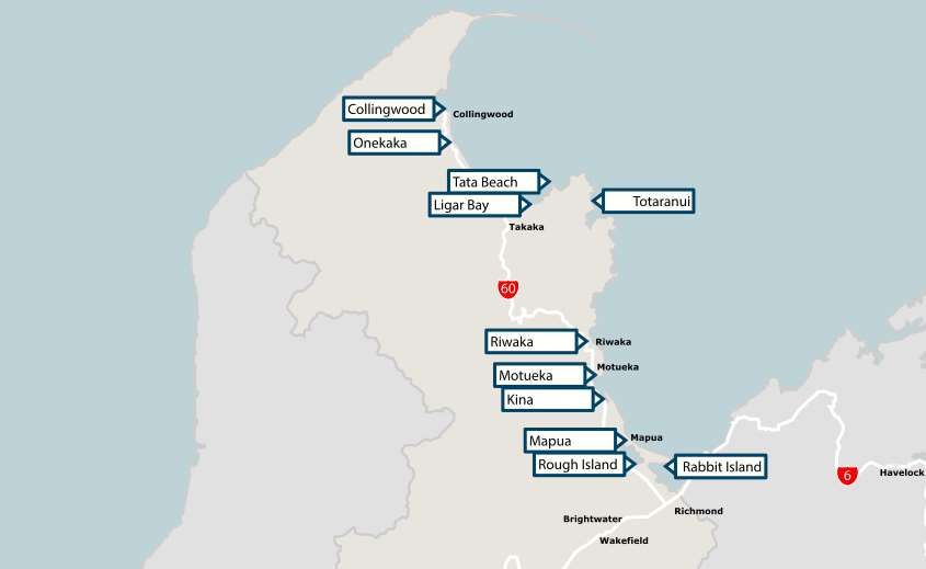
2.3      Ports
2.3.1    Port Motueka
Port Motueka (Location shown in Figure 1), first started operating in the early 1900s from the old wharf on
Motueka Quay. The wharf was moved to its existing location to the main Moutere inlet in 1916.
The original port authority was the Motueka Harbour Board which was constituted in 1905 and was endowed in
lands surrounding the area. They handed their authority and lands to the Waimea County Council in 1968, but the
Nelson Harbour Board fought the decision and was empowered to act as Harbour Authority (though Waimea
County Council retained control over the endowment land). The Nelson Harbour Board invested very little in the
Motueka Wharf during their period of authority from 1968 to 1989 and it was in poor condition when it was handed
over to Tasman District Council in 1989.
The Talley’s Group has been the major operator in Port Motueka since the early 1970s. They own part of the port
area south of Everett Street (where their office and processing factory is located) and lease further land for staff
car parking.
In 1994, Council embarked on the Port Motueka Improvement Project aimed to improve access through the
harbour to the port. A groyne was constructed to protect the main channel and dredging of the channel
completed. The groyne was removed in 2012.
The Motueka Yacht Club constructed a jetty in the estuary in 1994 and in 1997 the Motueka Power Boat Club
received resource consent to reclaim land for development of a boat ramp/car parking area. Council holds further
consents for the jetty and other area development works.
These recent developments caused concern that the port area was being developed in a piecemeal fashion and a
Task Force of Councillors and Council staff was set up to determine a future development concept and improve
port management. The Task Force prepared a 10-year development plan which described in more detail the
history, current land uses/zonings and set out a future development plan for the port area.
Council has transferred the ownership of the wharf and its facilities to the Talleys Group. Council is no longer
responsible for the maintenance of this asset. Sections of the Navigation Safety Bylaw relating to navigational
safety are managed by Council’s Harbourmaster. Endowment land is managed through Council’s Property
Services Manager.
As part of the ownership agreement a fishing platform was constructed by the Talleys Group next to the main
wharf for public use. This structure was divested to Council and Council is responsible for its maintenance.
The primary issue at the port is the lack of draught that is affected by the build up from the littoral drift process.
Talley’s, as owners of the wharf and primary operators through the port, are continuing attempts to manage these
processes. For Council the issue is the need to ensure navigational aids are properly located and adequately
maintained so recreational users have the appropriate notice and guidance.
Council will continue to manage the navigation aids, moorings, fishing platform and general safety by the port
users through its Harbour Bylaw and the Tasman Resource Management Plan for specific activities and
structures.

2.3.2    Port Mapua
Port Mapua (Location shown in Figure 1), first started operating in the early 1900s in line with many of the other
ports around Tasman Bay and Golden Bay. It was first established as the primary route for transporting goods
(predominately apples) for export or distribution. The goods were commonly shipped straight to Wellington, but
there was some movement around the regions. By 1912, the first cool store was built and growth in fruit export
from the port continued until 1950, when transportation and export through Port Nelson became the norm.
The port was then used by predominately recreational craft, but the channel and wharf were left to deteriorate.
Community intervention stepped in from 1980’s to repair the wharf and ensure its survival. In 1989, Council took
over the former Apple and Pear Board chemical factory site and measures were put in place to prevent
contaminated soil leaching into the adjoining Waimea inlet. Since 1990’s the area has steadily improved with a
number of restaurant, commercial and retail operations establishing to make the area an attractive destination for
holiday makers and residents alike.
In 1999, Council started remediation of the former chemical factory site which was completed in 2007. The land
is now a recreational area and additional carparking.
In recent years the establishment of Tasman’s Great Taste Trail through the Mapua Port has established a small
ferry to create a link between Mapua and Rabbit Island.

PAGE 9                                                             COASTAL ASSETS ACTIVITY MANAGEMENT PLAN
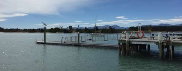
2.3.3     Port Tarakohe
Port Tarakohe (Location shown in Figure 1), is a port and marina owned and operated by Council as a
commercial operation. Due to its nature as a commercial operation, the asset is administered by Corporate
Services and as such included in the Commercial Activity Management Plan.

Figure 1: Location of Ports in Tasman

2.4       Wharfs
2.4.1     Riwaka Wharf
The wharf at the end of Wharf Road consists of an earth-filled concrete retaining wall which now has a solely
recreational value. The west wall was reconstructed in 1995. The walls are in relatively poor condition.
The structure is very rarely used by the public as a wharf and is typically used as a vehicle parking area for
recreational use and access to the coastal area. Considering the use of this structure, maintenance is more for
the benefit of the road and less to do with water access.

2.4.2     Mapua Wharf
The wharf (which is part of Port Mapua) consists of a timber structure with a timber deck. The wharf has ‘cool
store’ buildings that have been developed into community and commercial facilities. The buildings on the wharf
are administered by Corporate Services and included in the Commercial Activity Management Plan.
The wharf has a plastic floating jetty at the eastern end connected with an aluminum truss gangway.

PAGE 10                                                          COASTAL ASSETS ACTIVITY MANAGEMENT PLAN
Figure 2: Mapua Wharf

2.4.3     Other Wharves
Some previously Council-owned structures have been transferred to other parties such as wharves/jetties at
Collingwood, Milnethorpe and Mangarakau, which currently belong to DOC. These structures are in very poor
condition and pose a risk to public safety. Although Council is not the owner of these assets they have an interest
to ensure the assets are safe as they are in the public arena.
Table 2: Council Administered Wharves

 Wharf                    Location                Length                Materials             Condition

  Mapua                     Main Wharf             44.0 m                Timber                Moderate

  Riwaka                    Wharf Road             16.0 m                Concrete              Poor

PAGE 11                                                          COASTAL ASSETS ACTIVITY MANAGEMENT PLAN
Figure 3: Location of Wharves

2.5       Jetties
A summary of Council-owned jetties is listed in Table 3 and locations shown in Figure 4 below.
Table 3: Council Administered Jetties

 Jetty                 Location                Length                Materials               Condition

  Best Island            South eastern          12.5 m                 Timber                    Moderate
                         corner by Best
                         Island

  Marahau                Main Beach             19.0 m                 Timber                    Very Good

  Mapua                  Eastern end of         20.1 m                 Plastic/Aluminum          Good
                         wharf

  Motueka                Moutere Inlet          15.0 m                 Timber                    Good

The Marahau jetty is maintained by Council and the Torrent Bay jetty is maintained and funded by the local
residents with some financial support from Council.

PAGE 12                                                         COASTAL ASSETS ACTIVITY MANAGEMENT PLAN
Figure 4: Location of Jetties 2.6 Coastal Protection There are significant lengths of coastal protection works in Tasman. Some of these are private works constructed with or without the appropriate consents, usually with the intent to protect built environments such as housing. Others are protecting the adjoining road asset that provides necessary access along the coast and are therefore included in the Transportation activity. A substantial portion of these works are above Mean High Water Spring (MHWS) and not in the Tasman Coastal Marine Area. Between 2003 and 2007, Council, in conjunction with the local community, completed substantial coastal protection at Marahau and Ruby Bay (Broadsea Avenue and Old Mill Walkway). These have been constructed to protect existing urban development and built to a higher standard than earlier works. Earlier constructed protection works have little to no design details and therefore maintenance to the design standard is challenging. There are also rock revetments that are known but are yet to be included in the Confirm database. Coastal protection asset data has been poorly captured until now. Council plans to address this issue by identifying all coastal protection assets and recording them in the Confirm database. PAGE 13 COASTAL ASSETS ACTIVITY MANAGEMENT PLAN
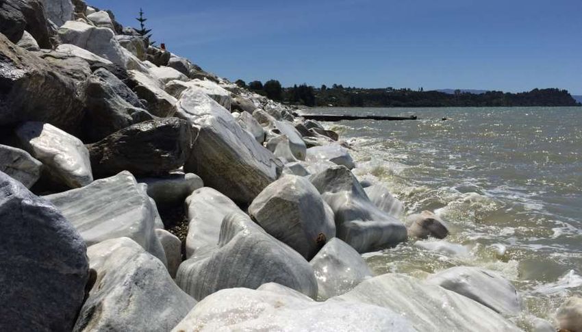
Figure 5: Marahau Sea Wall
A list of Council’s coastal protection assets is in Table 4 and approximate locations are shown in Figure 6 below.
Table 4: Council Administered Coastal Protection

 Location                                    Length                  Materials               Condition

  Mapua – In front of Waterfront Park          62.0 m                  Rock / Concrete        Good

  Marahau – Road frontage                      65.0 m                  Rock                   Good

  Torrent Bay – West of Torrent Bay            22.0 m                  Timber                 NA
  Jetty

  Collingwood – Puponga Main Road,             227.0 m                 Rock                   Good
  south of Manuka Creek

  Collingwood – North of Taupata               132.0 m                 Rock                   Poor
  Stream Bridge on Collingwood-
  Puponga Main Road

  Collingwood – 200m South of                  163.0 m                 Rock                   Moderate
  Taupata Stream Bridge on
  Collingwood-Puponga Main Road

  Collingwood – 1735 Collingwood               145.0 m                 Rock                   Moderate
  Puponga Main Road

  Collingwood - 500m north of 1653             314.0 m                 Rock                   Very Poor
  Collingwood-Puponga Main Road

  Collingwood - 100m north of Onetaua          43.0 m                  Rock                   Good
  Bridge

PAGE 14                                                          COASTAL ASSETS ACTIVITY MANAGEMENT PLAN
Location                               Length         Materials         Condition

  Collingwood – 1004 to North of 911     760.0 m        Rock              Good
  Collingwood-Puponga Main Road

  Collingwood – 1312 Collingwood-        84.0 m         Rock              Moderate
  Puponga Main Road

  Collingwood - 1312 Collingwood-        112.0 m        Rock              Good
  Puponga Main Road

  Collingwood - 1224 - 1228              160.0 m        Rock              Moderate
  Collingwood-Puponga Main Road

  Collingwood - Opposite 1215            11.0 m         Rock              Moderate
  Collingwood-Puponga Main Road

  Collingwood - 3 to 65 Totara Avenue    1,180 0m       Rock              Good

  Collingwood - 553 to near 758          45.0 m         Rock              Moderate
  Collingwood-Puponga Main Road

  Collingwood - 300m North of Mt         37.0 m         Rock              Moderate
  Burnett Road on Collingwood-
  Bainham Main Road

  Collingwood – Puponga Main Road,       58.0 m         Rock              Moderate
  opposite Mt Burnett Road

  Collingwood - 130m South of Mt         75.0 m         Rock              Moderate
  Burnett Road on Collingwood-
  Bainham Main Road

  Collingwood - Collingwood-Bainham      27.0 m         Rock              Poor
  Main Road at Marble Creek

  Collingwood - Gorge Creek Bridge on    15.0 m         Rock              Poor
  Collingwood-Bainham Main Road

  Collingwood - Haven Road / Tasman      61.0 m         Rock              Moderate
  Street / Boat Park - Boat Park

  Collingwood - From boat ramp           250.0 m        Rock              Moderate
  following Aorere River on N side of
  Collingwood motor camp

  Pohara - 823 - 866 Abel Tasman         280.0 m        Rock              Good
  Drive

  Takaka - West side of causeway on      360.0 m        Rock              Very Poor
  Waitapu Wharf Road at entrance to
  Waitapu Wharf

  Takaka - East side of causeway on      310.0 m        Rock              Poor
  Waitapu Wharf Road at entrance to
  Waitapu Wharf

PAGE 15                                             COASTAL ASSETS ACTIVITY MANAGEMENT PLAN
Location                                 Length          Materials         Condition

  Ruby Bay – Old Mill Seawall Stage 1      778.0 m         Rock              Very Good

  Ruby Bay – Old Mill Seawall Stage 2      505.0 m         Rock              Very Good

  Ruby Bay – Ruby Bay Seawall              416.0 m         Rock              Very Good

  Motueka - beach in front of 93           10.0 m                            NA
  Trewavas Street

  Mapua - near wharf, close to where       15.0 m          Concrete          Good
  Fairy picks up passengers

  Mapua – Leisure park south facing        94.0 m          Rock              Moderate

  Mapua – Leisure park southern point      205.0 m         Rock              Moderate
  to under the cafe

  Mapua – Leisure park inlet mouth to      1,050.0 m       Rock              Very Good
  concrete seawall

  Riwaka - Eastern side of Green Tree      107.0 m         Concrete/Rock     Moderate
  Lane

  Puponga - Main Road Puponga              410.0 m         Rock              Good

  Collingwood - Starts opposite 1397       30.0 m          Rocks             Very Poor
  Collingwood-Puponga Road

  Pohara - Beach front of Pohara top 10    611.0 m         Rocks             Good
  holiday park

  Collingwood - Beach Road Northeast       516.0 m         Rocks             Moderate
  end. Starting western side of 49
  Beach Road

  Milninthorpe - West of derelict wharf    25.0 m          Rocks             Moderate

PAGE 16                                                COASTAL ASSETS ACTIVITY MANAGEMENT PLAN
Figure 6: Location of Coastal Protection Assets

2.7       Boat Ramps
Boat ramps include concrete and gravel constructions and vary considerably in user demand. A summary of the
boat ramps is below in Table 5. This summary has been compiled from information from the Confirm database,
the Coastal Structures Inspections Report completed in September 2009, and the Harbourmaster.
Nine boat ramps are concreted, the balance are gravel/unformed. There are other boat ramps within the District,
however these are privately owned and operated. This includes the Kaiteriteri Beach boat ramp which is under
management of the Kaiteriteri Domain Board, and the Port Motueka boat ramp which is under management of the
Motueka Power Boat Club.

Figure 7: Marahau Boat Ramp

PAGE 17                                                        COASTAL ASSETS ACTIVITY MANAGEMENT PLAN
Table 5: Council Administered Boat Ramps

 Location                   Length         Lanes            Surface           Condition

  Best Island –              16.0 m         1                Concrete          Poor
  Adjacent to jetty on
  eastern side of island

  Mapua – Adjacent to        20.0 m         1                Concrete          Moderate
  wharf

  Mapua – Grossi Point       Undefined      Undefined        Unformed          Moderate

  Marahau - Waterfront       27.0 m         2                Concrete          Very Good

  Marahau - Estuary          8.0 m          1                Concrete          Moderate

  Murchison – at             10.0 m         1                Concrete          NA
  Riverview Holiday
  Park

  Rakopi - Dry Road          5.0 m          1                Sand & Gravel     Very Poor
  Westhaven Inlet

  Motueka – In front of      9.0 m          1                Timber /          Poor
  111 Trewavas Street                                        Concrete

  Mapua - leisure camp       20.0 m         1                Concrete          Moderate
  inlet in front of cafe.

  Ruby Bay – Chaytor         30.0 m         1                Concrete          Good
  Reserve, Broadsea
  Avenue

  Motueka - South of         25.0 m         1                Unformed          Poor
  Motueka bridge off
  Main Road Riwaka

  Motueka - north of         20.0 m         1                Unformed          Poor
  Motueka Bridge

  Motueka - 100 metres       50.0 m         1                Unformed          Moderate
  north of Motueka
  bridge

  Riwaka - West of two       20.0 m         Pedestrian       Concrete          Poor
  boat sheds on Wharf
  Road

  Riwaka - 20 metres         10.0 m         1                Concrete          Moderate
  East of Wharf

  Riwaka – End of            16.0 m         1                Concrete          Good
  Green Tree Road

  Ligar Bay - 200            20.0 m         1                Concrete          Poor
  metres North from the
  road

PAGE 18                                                  COASTAL ASSETS ACTIVITY MANAGEMENT PLAN
Location                 Length     Lanes      Surface           Condition

  Collingwood - Easter     50.0 m     2          Concrete          Good
  boat ramp at William
  Street southern
  carpark

  Collingwood - 50         5.0 m      1          Unformed          Moderate
  metres West from 49
  Beach Road

  Patrons Rock –           20.0 m     1          Sand              Moderate
  Opposite 216 Patons
  Rock Road

  Patrons Rock –           50.0 m     1          Unformed          Moderate
  Battery Road

  Rangihaeata Head -       100.0 m    1          Unformed          Moderate
  Keoghan Road end

  Takaka - Takaka          30.0 m     1          Gravel            Good
  River freedom
  camping space
  adjacent to SH60
  Bridge

Figure 8: Location of Boat Ramps

PAGE 19                                      COASTAL ASSETS ACTIVITY MANAGEMENT PLAN
2.8        Aids to Navigation
As a Harbour Authority, Council is responsible for navigational safety and the provision of navigational aids for
access into local ports. The Maritime Safety Authority provides navigational aids marking significant geographical
features for coastal navigation and to mark more significant dangers to regional navigation.
There are formal lease arrangements for some navigational aids located on private property. There have been
some minor issues to date with access to those navigational aids on properties where no formal easement or
agreement of entry has been negotiated.
Council owns and maintains a number of lead lights and marker buoys. Recently, Council has undertaken work
to develop an asset register which is held in the Confirm database. The information has been updated and is
summarised in Table 6 and shown in Figure 9 below.
Table 6: Council Administered Navigational Aids

 Area               Feature        Type               Number     Location            Description

  Rough               Post          Transit            4           Hunter             Black and faded
  Island                                                           Brown -            orange bands
                                                                   North end
                                                                   (Mapua
                                                                   end)

  Kina                Post          Reservation        4           Kina -             Black and white
                                                                   South and          bands
                                                                   North end

  St Arnaud           Post          Ski Lane           2           Lake Rotoiti       Orange and black
                                                                                      bands

  Motueka             Post          Beacon             2           Marking the        Green and red
                                                                   channel and        reflective tape
                                                                   training wall      band

  Motueka             Buoy          Marker             1

  Motueka             Post          Sign               8           On marina          Combination of
                                                                                      railway irons and
                                                                                      piles with signs
                                                                                      and cones

  Onekaka             Mark          Cardinal           1           End of             EC top mark on
                                                                   derelict           white post
                                                                   wharf

  Rabbit              Post          Transit            3           Marking ski        Black & White
  Island                                                           lane limits        bands

  Riwaka              Buoy          Fairway            1           Marks              Green
                                                                   landfall to        retroreflective tape
                                                                   tidal flats

  Tata Beach          Post          Transit            2           North and          Orange and black
                                                                   South end          bars with sign
                                                                   of transit
                                                                   lane

  Totaranui           Post          Transit            2           North and          Orange and black
                                                                   South end          bars with sign
                                                                   of transit
                                                                   lane

PAGE 20                                                         COASTAL ASSETS ACTIVITY MANAGEMENT PLAN
Area Feature Type Number Location Description
Collingwood Buoy Lateral 5 Entrance to Green and Red
Collingwood Spar Shape
and Aorere
River
Collingwood Buoy Special 2 Entrance to ‘5 knot sign’
Collingwood
/ Aorere
River
Riwaka Buoy Lateral 1 Riwaka TDC sticker and
Fairway engraved "03 543
Buoy 8400" and "179".
2800m from Green tape strips
Riwaka vertical around
Jetty top.
Motueka Buoy Lateral 1 Motueka Green Spar Shape
River
Fairway
Beacon
Mapua Buoy Lateral 2 Mapua TDC sticker and
Fairway engraved "03 543
Buoy 8400" and "178".
Green tape strips
vertical around
top.
Mapua Post Lateral 2 Mapua 700m high panel
Outer of reflective tape.
Starboard 4.5m ladder. Pole
Pile unpainted. No top
mark.
Collingwood Buoy Fairway 1 Entrance to Black Mussel
Collingwood Float
/ Aorere
River
Ligar Bay Post Lateral 2 Golden Bay Steel pole
Ligar Bay
PAGE 21 COASTAL ASSETS ACTIVITY MANAGEMENT PLANFigure 9: Location of Aids to Navigation PAGE 22 COASTAL ASSETS ACTIVITY MANAGEMENT PLAN
3         Strategic Direction
Strategic direction provides overall guidance to Council and involves specifying the organisation's
objectives, developing policies and plans designed to achieve these objectives, and then allocating
resources to implement the plans.

3.1       Our Goal
 Council aims to ensure access to the sea can be enjoyed by all whilst managing the effects of the sea on property.

3.2       Contribution to Community Outcomes
Council operates, maintains and improves the coastal assets on behalf of its ratepayers. Council undertakes the
activity to meet the level of service that is required to enhance community well-being by improving access to the
sea and managing the interaction of the coast on property.
The coastal activity contributes to the community outcomes as detailed in Table 7 below.
Table 7: Community Outcomes

                               Does Our Activity
                               Contribute to the
 Community Outcomes                                      Discussion
                               Community
                               Outcome

  Our unique natural                                      We manage our assets so that they do not impact the
  environment is healthy,                                 health and cleanliness of the receiving environment.
                                 Yes
  protected and
  sustainably managed.

  Our urban and rural                                     We ensure our coastal structures are operated without
  environments are                                        causing public health hazards and by providing
  people-friendly, well-                                  attractive recreational and commercial facilities.
                                 Yes
  planned, accessible
  and sustainably
  managed.

  Our infrastructure is                                   We provide access for commercial and recreational
  efficient, cost effective                               activities that meets the community needs at an
                                 Yes
  and meets current and                                   affordable level.
  future needs.

                                                          Coastal assets provide recreational opportunities to
  Our communities are
                                                          improve health and wellbeing. Coastal protection
  healthy, safe, inclusive       Yes
                                                          assets and services improve our community’s
  and resilient.
                                                          resilience to storm events and climate change.

                                                          Seafaring and marine transportation are a large part of
  Our communities have
                                                          the history of the district. Many of the remaining
  opportunities to
                                                          coastal assets have a connection with our history of
  celebrate and explore          Yes
                                                          moving people and goods between the sea and land.
  their heritage, identity
                                                          This activity preserves many of these historical
  and creativity.
                                                          structures.

  Our communities have                                    Coastal protection seeks to preserve reserves and
  access to a range of                                    other reactional activities from erosion for the benefit of
  social, cultural,                                       the whole community.
                                 Yes
  educational and
  recreational facilities
  and activities.

PAGE 23                                                            COASTAL ASSETS ACTIVITY MANAGEMENT PLAN
Does Our Activity
Contribute to the
Community Outcomes Discussion
Community
Outcome
Our Council provides
leadership and fosters
partnerships, a
No
regional perspective,
and community
engagement
Our region is Tourism is and will continue to play a large part in the
supported by an district. Access to the water for recreational and
Yes
innovative and commercial activities will be key to its continued
sustainable economy. growth.
3.3 Infrastructure Strategy
Council’s Infrastructure Strategy covers the assets needed to support Council’s water supplies, stormwater,
wastewater, rivers and flood control, and transportation activities.
The purpose of the Strategy is to identify the significant infrastructure issues for Tasman over the next 30 years,
and to identify the principal options for managing those issues and the implications of those options.
When setting out how Council intends to manage the District’s infrastructure assets and services, it must consider
how:
to respond to growth or decline in demand;
to manage the renewal or replacement of existing assets over their lifetime;
planned increases or decreases in levels of service will be allowed for;
public health and environmental outcomes will be maintained or improved; and
natural hazard risks will be addressed in terms of infrastructure resilience and financial planning.
There are three parts to the Strategy; the Executive Summary, the Strategic Direction, and the Activity
Summaries. The Strategic Direction section sets the direction for infrastructure management and outlines the key
priorities that Council will focus on when planning and managing its infrastructure. The Activity Summaries
section provides an overview of each activity and is largely a summary of the relevant activity management plan.
The four key infrastructure priorities included in the Strategy are:
Providing infrastructure services that meet the needs of our changing population
Planning, developing and maintaining resilient communities
Providing safe and secure infrastructure and services
Prudent management of our existing assets and environment
These priorities have been used to determine and prioritise what is required to be included in the programmes of
work for each activity management plan.
3.4 Financial Strategy
The Financial Strategy outlines Council’s financial vision for the next 10–20 years and the impacts on rates, debt,
levels of service and investments. It will guide Council’s future funding decisions and, along with the
Infrastructure Strategy, informs the capital and operational spending for the Long Term Plan 2018-2028.
Three key financial limits are established in the Financial Strategy that set Council’s overall financial boundaries
for its activities. These include:
Rates Income - limited to $65 million per annum and targeted rates to $60 million per annum.
Rates Increases - limited to a maximum of 3% per annum, plus an allowance for annual growth in rateable
properties.
Debt - net external debt limited to a maximum of $200 million
Infrastructure expenditure forms a large proportion of Council’s spending being 39% of operational expenditure
and 80% of capital expenditure over the next 10 years. Because of this, the Infrastructure Strategy and Financial
Strategy are closely linked to ensure the right balance is struck between providing the agreed levels of service
within the agreed financial limits. Often these financial limits will influence how Council manages and develops
existing and new assets. This is especially so for the next 10 years.
PAGE 24 COASTAL ASSETS ACTIVITY MANAGEMENT PLANOver the next 10 years, forecast rate income increases and debt levels are projected to be near Council’s limits. Council has had to work hard to prioritise and plan a work programme which addresses key issues while staying within these limits. Given Council’s debt is projected to peak at $199.6m in Year 2020/21 there is very little scope to add further work programmes in the next five years. 3.5 Key Issues 3.5.1 Disaggregated Management Coastal Assets are spread amongst different departments and teams within Council. Additionally, there is a number of coastal assets that ownership is unclear with many believing that Council has ultimate responsibility. This has meant that management of these assets has varied. The departments that have coastal assets are: Transportation (Engineering Services) – Looks after council and community coastal protection structures, jetties, boat ramps markers and signs; Commercial (Corporate Services) – Managers Port Tarakohe and a number of smaller coastal assets that are on the property of commercial facilities; Reserves and Facilities (Community Development) – Managers parks and reserves with the associated facilities which includes, seawall and beach access points. In addition, there are a number of coastal assets to which ownership is ambiguous. In some cases, this is due to a third party building it and now they no longer exist or an assumption of Council management by the community. 3.5.2 Boat Ramps The connection to the sea is one of the features that defines Tasman District. Beaches, estuaries and islands are enjoyed by almost everyone. Access to the water has been difficult, in part due to the high tidal range (3.5 – 4.0 metres) and in part due to the relatively shallow bays that define the majority of the coast. There are over 67 boat access locations along the coast. Of these 50% are unformed, 50% are beach access only, 75% are suitable for dinghy and small boats only. No ramps have additional supporting facilities such as wash down facilities or toilets. In recent years recreational boating has changed in the Tasman District. There has been an increase in the size of new boats making the unformed ramps difficult to use for a growing portion of boats. Good launching facilities at Nelson, Motueka and Kaiteriteri are busy and have car parking issues. This is predominately due to fine weather and availability for recreational activities coinciding for many users of the facilities. Queuing time for boat ramp use in Nelson can be up to an hour long and people can have to walk up to 1km after finding a car park. Likewise, parking is an issue in Kaiteriteri, but to a lesser extent. 3.5.3 Asset Knowledge Not enough is known about the coastal assets in the District. There are a number of assets that are not recognised in Council records. This has led to lack of maintenance and in some cases premature failure. Many of the assets that are recognised by Council have incomplete records and a lack of accurate condition rating. This means that the only way of scheduling maintenance is reactive, to Customer Service Requests and Council staff observed problems. There are a number of derelict structures around the region that have been abandoned, most have not been identified. Legal advice is that Department of Conservation should have responsibility for the structures. The structures are still highly valued by the public, either as a vessel mooring or due to aesthetic or photographic opportunities. Over the years, the timber structures have deteriorated to a point that they pose a navigational or safety hazard to the public. 3.5.4 Coastal Protection Urban development along coastal margins, coastal erosion and potential sea level inundation associated with climate change all increase the demand for coastal protection works. Council is planning to maintain existing Council-owned coastal protection works and recreational assets, but will not provide any increased levels of protection to properties or new recreational assets. Council is also developing resource management policies to manage growth in coastal hazard areas to reduce the likelihood of further areas being developed that could be at risk from inundation from the sea and the need for coastal protection work for these areas. Modelling of the Tasman coastline is occurring and a full review of coastal polices is expected in the next three years. In the meantime, an interim coastal policy has been developed explaining Council’s priorities for maintenance of existing coastal structures. PAGE 25 COASTAL ASSETS ACTIVITY MANAGEMENT PLAN
3.6 Prioritisation Council cannot afford to undertake all work at once due to financial and resource constraints. This means that Council needs to prioritise what work it undertakes first, and what work can wait until later. There are multiple factors that affect the priority of individual works. These include: The need to protect public health & safety Statutory compliance Meeting the needs of tomorrow’s population Readiness to implement works Co-funding opportunities Enabling pleasant community environments Benefits and risks District distribution Strategic fit Council has taken all of the above into consideration when planning its programme of work. Generally, mandatory requirements such as statutory compliance take priority, and discretionary activities have been programmed second to this. 3.7 Interim Coastal Position An increasing number of storm events in the district have caused considerable damage and erosion along parts of the Tasman coastline. Community expectations for the Council to protect private property is unaffordable, so an interim position statement was developed while further modelling and investigation work into the effects of climate change and sea level rise on the Tasman district are assessed. The interim position statement is: The Council will maintain or repair only existing Council-owned coastal protection structures (subject to a review of economic benefit and affordability and compliance with NZCPS and TRMP) The Council will consider new investment in coastal protection works only where there are substantial Council- owned capital works, assets or infrastructure at risk and it is impracticable to relocate Council assets (subject to compliance with the NZCPS and the TRMP) The Council will not invest in or maintain any new Council-owned coastal structures or works to protect private property, nor will it accept responsibility for repair or maintenance of existing private coastal works The Council will only give consideration to allow any privately funded construction of shoreline protection structures on Council-owned land, for the purposes of protecting Council-owned land or private property, where a proposal is substantially compliant with the objectives and policies of the NZCPS and objectives, policies and rules of the TRMP, and Council’s Reserves General Policies document. In any event the Council retains complete discretion regarding authorisation of private structures on Council-owned land. PAGE 26 COASTAL ASSETS ACTIVITY MANAGEMENT PLAN
4 Key Linkages There are multiple factors that influence how Council manages this activity. They can be internal or external and include legislation, policies, regulations, strategies and standards. This section summarises these key linkages. Figure 10: Coastal Assets AMP and Relationship with other Documents In preparing this AMP the project team has taken account of: National Drivers – for example the drivers for improving Asset Management through the Local Government Act 2002 Local Drivers – community desire for increased level of service balanced against the affordability Industry Guidelines and Standards Linkages – the need to ensure this AMP is consistent with all other relevant plans and policies Constraints – the legal constraints and obligations Council has to comply with in undertaking this activity. The main drivers, linkages and constraints are described in the following sections. 4.1 Key Legislation The Acts below are listed by their original title for simplicity however all Amendment Acts shall be considered in conjunction with the original Act, these have not been detailed in this document. For the latest Act information refer to http://www.legislation.govt.nz/. PAGE 27 COASTAL ASSETS ACTIVITY MANAGEMENT PLAN
Figure 11: Summary of Key Legislation that Relates to this Activity

 Legislation                                            Effect on this Activity

  The Local Government Act 2002                          The Local Government Act requires local authorities
                                                         to prepare a ten-year Long Term Plan and 30-year
                                                         Infrastructure Strategy, which are to be reviewed
                                                         every three years. The Act requires local authorities
                                                         to be rigorous in their decision-making by identifying
                                                         all practicable options and assessing those options
                                                         by considering the benefits and costs in terms of the
                                                         present and future well-being of the community.
                                                         This activity management plan provides information
                                                         to support the decisions considered in the Long
                                                         Term Plan.

  The Biosecurity Act 1993                               This act defines, pest surveillance, prevention and
                                                         management.

  The Civil Defence Emergency Management Act             This Act promotes the management of hazards.
  2002 (Lifelines)                                       This includes mitigating flood risk which includes
                                                         planning for emergencies, response and recovery
                                                         from an event.

  The Resource Management Act 1991                       This Act sets out obligations to protect New
                                                         Zealand’s natural resources such as land, air,
                                                         water, plants, ecology, and stream health. Resource
                                                         consents draw their legal authority from the
                                                         Resource Management Act 1991.

  The Maritime Transport Act 1994                        This Act sets our Councils obligations as a unitary
                                                         authority for ports, harbours and waters where
                                                         marine related activities are undertaken.

4.2       Key Planning, Policies and Strategies
4.2.1     National Policies, Regulations and Strategies
Table 8: Summary of National Documents that Relates to this Activity

 Documentation                                          Effect on this Activity

  The New Zealand Coastal Policy Statement 2010          The policy statement informs the Tasman Regional
                                                         Management Plan and Council must give
                                                         consideration the policy statement during consent
                                                         consideration on anything around the coast.

  NAMS Manuals and Guidelines                            International best practice guideline to asset
                                                         management practice; covering a wide range of
                                                         asset and infrastructure related topics, including
                                                         detailed advice on how to improve asset
                                                         management.

  Maritime Rules, Part 91 – Navigational Safety Rules    This rule describes the requirements around
                                                         marking of on water access lanes.

4.2.2     New Zealand Standards
Table 9: Summary of Standards that Relates to this Activity

 Standard                                               Effect on this Activity

PAGE 28                                                       COASTAL ASSETS ACTIVITY MANAGEMENT PLAN
AS 3962 2001 Guideline for design of marinas Provides guidance on marine facilities for vessels
up to 50m in length.
4.2.3 Local Policies, Regulations, Standards and Strategies
Table 10: Summary of Local Documents that Relates to this Activity
Documentation Effect on this Activity
Tasman District Council District Plan – Tasman The plan is the guiding document for all activities
Resource Management Plan (TRMP) undertaken in the district. This dictates and shapes
the forward works and capital programmes but also
influence the consent and permissions required
when undertaking any construction.
Tasman Regional Policy Statement (TRPS) An overview of significant resource management
issues with general policies and methods to address
these. Part 9 Coastal Environment outlines the
occupation and use of the coastal marine area as
well as water borne navigation and safety.
Tasman District Council Procurement Strategy The procurement strategy dictates the process for
all procurement at Council. The strategy does cater
for scale and size of the acquisition.
PAGE 29 COASTAL ASSETS ACTIVITY MANAGEMENT PLAN5 Levels of Service A key objective of this plan is to match the levels of service provided by this activity with the agreed expectations of our customers and their willingness to pay for that level of service. These levels of service provide the basis for the life cycle management strategies and works programmes identified in this plan. Levels of service can be strategic, tactical, operational or implementational and should reflect the current industry standards and be based on. Customer Research and Expectations: Information gained from stakeholders on expected types and quality of service provided. Statutory Requirements: Legislation, regulations, environmental standards and Council bylaws that impact on the way assets are managed (ie. resource consents, building regulations, health and safety legislation). These requirements set the minimum level of service to be provided. Strategic and Corporate Goals: Provide guidelines for the scope of current and future services offered and manner of service delivery, and define specific levels of service, which the organisation wishes to achieve. Best Practices and Standards: Specify the design and construction requirements to meet the levels of service and needs of stakeholders. 5.1 Our Levels of Service Table 11 summarises the levels of service and performance measures for this activity. The light blue shaded rows show those that are included in the Long Term Plan and reported in the Annual Plan. Unshaded white rows are technical measures that are only included in the activity management plan. PAGE 30 COASTAL ASSETS ACTIVITY MANAGEMENT PLAN
Table 11: Levels of Service

                           Performance Measure                                                      Future Performance Targets
Levels of Service
                           (we will know we are meeting the level of service if Current Performance Year 1        Year 2         Year 3    Year 10
(we provide)
                           …)                                                                       2018/19       2019/20        2020/21   2028/29

 Protection                   Council owned coastal protection is maintained to its    Actual = New   100%        100%            100%      100%
                              original constructed standard.                           measure
 Our communities are
 protected from natural       Council has a detailed inventory of coastal assets and
 hazard events                condition
                              As measured by routine inspections after storm
                              events.

 Safety                       Council structures are maintained to a safe level to     Actual = New   100%        100%            100%      100%
                              allow general public to use.                             measure
 Our structures are safe
 for the public to use        Measure percentage of structures deemed ‘safe’
                              through annual safety audit.

 Amenity                      Residents are satisfied with Council’s coastal assets    Actual = New   ≥ 70%       ≥ 70%           ≥ 70%     ≥ 70%
                              in the district.                                         measure
 The coastal assets are
 maintained to an             As measured through the annual Communitrak
 appropriate level and        survey.
 satisfies the
 community’s
 expectations

PAGE 31                                                                                                       COASTAL ASSETS ACTIVITY MANAGEMENT PLAN
5.2 Level of Service Changes
Council reviews its levels of service every three years, as part of the Long Term Plan development. Table 12
below summaries the key changes Council has made during development of the Long Term Plan 2018 – 2028.
Table 12: Summary of areas where we made changes to our levels of service
Performance Measure Summary of change
Structures Safety Added new performance measure to ensure that coastal assets are fit for
public use.
Structures Safety Removed council response performance measure which will be reported on
my Support Services
Amenity New performance measure added to measure residents satisfaction with the
coastal assets.
5.3 Levels of Service Analysis and Performance
5.3.1 Protection
There are a small number of coastal protection works that have good design intent information, they are also the
largest protection structures and therefore important to maintain. All other coastal structures have little or no
design information, but this shows that they are not critical assets. If any of the protection structures do become
critical assets, a higher degree of scrutiny will be undertaken with retrospective engineering design review.
The level of service measure requiring compliance with resource consents has been removed. Compliance with
the consents should be implied, and not used as a measure of performance for this activity.
5.3.2 Safety
The public safety level of service measure is new. It is to ensure that coastal assets are suitable for public use
and maintained in a condition that would not provide undue risk to those using them. This is particularly important
given the number of poor or derelict structures within the District.
This level of service also ties into the additional asset condition inspections that will be undertaken as part of this
AMP. Previously, the safety level of service focussed on the response of Council to customer service requests.
This previous measure has been removed from this activity, is still applied to Council through the Support
Services performance measures.
5.3.3 Amenity
A new amenity performance measure has been added to ensure this activity has a customer focus. This uses the
Communitrak survey to measure resident’s satisfaction with coastal assets. This measurement of resident’s
satisfaction has not been measured consistently in the past with the question asked sporadically over the last 20
years. However, there has been a question that asks whether residents think more, about the same or less
should be spent of different asset categories. Coastal assets is commonly high for the assets that residents want
more money spent on. This measure will track Council’s progress with customer expectations.
PAGE 32 COASTAL ASSETS ACTIVITY MANAGEMENT PLAN6 Our Customers and Stakeholders Council consults with the public to gain an understanding of customer expectations and preferences. This enables Council to provide a level of service that better meets the community’s needs. 6.1 Stakeholders There are many individuals and organisations that have an interest in the management and/or operation of Council’s assets. Council has a Stakeholder and Engagement Policy which is designed to guide the expectations with the relationship between Council and the Tasman community. Council has made a promise to seek out opportunities to ensure the communities and people it represents and provides services to have the opportunity to: be fully informed; provide reasonable time for those participating to come to a view; listen to what they have to say with an open mind; acknowledge what we have been told; inform contributors how their input influenced the decision that Council made or is contemplating. Engagement or consultation: is about providing more than information or meeting a legal requirement; aids decision-making; is about reaching a common understanding of issues; is about the quality of contact not the amount; is an opportunity for a fully informed community to contribute to decision-making. The key stakeholders Council consults with about the Coastal Structures activity are: Elected members (Community Board members); Iwi (Council’s Treaty Partners); Regulatory (Consent compliance); Fisheries organisations; Heritage New Zealand; Service providers / suppliers; Civil Contractors (Nelson-Marlborough); Affected or interested parties (when applying for resource consents); Neighbours. 6.2 Consultation 6.2.1 Purpose and Types of Consultation Council consults with the public to gain an understanding of customer expectations and preferences. This enables Council to provide a level of service that meets the community’s needs. Council’s knowledge of customer expectations and preferences is based on: feedback from residents’ surveys; other customer/user surveys, such as Yardstick visitor measures; levels of service consultation on specific issues; feedback from staff customer contact; ongoing staff liaison with community organisations, user groups and individuals; public meetings; feedback from elected members, advisory groups and working parties; analysis of customer service requests and complaints; consultation via the Annual Plan and Long Term Plan processes; and PAGE 33 COASTAL ASSETS ACTIVITY MANAGEMENT PLAN
consultation on Strategies and Reserve Management Plans.
Council commissions residents’ surveys on a regular basis (the National Research Bureau Ltd has provided this
service since 2008). These NRB CommunitrakTM surveys assess the levels of satisfaction with key services,
including provision of community facilities, and the willingness across the community to pay to improve services.
Other informal consultation is undertaken with community and stakeholder groups on an issue by issue basis, as
required.
6.2.2 Consultation Outcomes
The most recent NRB Communitrak™ survey was undertaken in May 2017. This asked whether residents were
satisfied with the District’s recreational facilities, multi-purpose public halls and community buildings and public
toilets.
Council consults with the public to gain an understanding of customer expectations and preferences. This enables
Council to provide a level of service that better meets the community’s needs.
public meetings;
feedback from elected members, advisory groups and working parties;
analysis of customer service requests and complaints;
consultation via the Annual Plan and Long-Term Plan (LTP) process.
Council commission’s customer surveys on a regular basis (since 2008) from the National Research Bureau Ltd.
These Communitrak surveys assess the levels of satisfaction with key services and the willingness across the
community to pay to improve services.
From time to time Council undertakes focused surveys to get information on specific subjects or projects. The
most recent NRB Communitrak survey was undertaken in May 2015. This asked whether residents were satisfied
with the management of Coastal Structures. The results from this survey are summarised in Figure 12.
Don't Know
21% Very Satisfied
23%
Not Very
Satisfied
13%
Fairly Satisfied
43%
Figure 12: Satisfaction with Management of Coastal Structures
The survey showed that 65% of residents are satisfied with Council’s management of coastal structures. The
main reasons residents are not very satisfied with Council’s management of coastal structures are:
coastal protection/foreshore/sea frontages/rock walls,
needs improvement/not enough being done/take too long,
financial issues,
erosion issues,
need to listen/communicate.
Of the 13% showing dissatisfaction, 31% resided in Golden Bay and 24% in Motueka.
Twenty one percent of residents surveyed were unable to comment on their satisfaction with Council’s coastal
structures. This is probably owing to the distance they live from the coast like Lakes-Murchison which 51% that
didn’t know.
PAGE 34 COASTAL ASSETS ACTIVITY MANAGEMENT PLAN7 Current and Future Demand The ability to predict future demand for services enables Council to plan ahead and identify the best way of meeting that demand. That may be through a combination of demand management and investing in improvements. This section provides and overview of key drivers of demand and what demand management measures Council has planned to implement. 7.1 Demand Drivers The future demand for coastal assets will change over time in response to a wide range of influences, including: Population Growth; Tourism Growth; Community Expectations; Climate Change and sea level rise. Council has not previously quantified actual usage of assets to determine actual changes in demand. Council will establish a process to assess boat ramp usage as an indicator for use of other coastal assets and establish trends. 7.2 Assessing Demand 7.2.1 Population Growth The link between population growth and the demand for coastal assets is not direct. Population growth does lead to the intensification of the use of existing facilities for recreation and demand for further housing development close to the coast. The potential effects of this on this activity are: increased use of port, wharf, mooring, marina and boat ramp facilities for recreation; increased community expectation to provide coastal protection. Council has encouraged the use of the coastal wharves and boat ramp facilities together with the opportunity to lease buildings for associated activities (boat clubs) and commercial users. Council will continue to allow the use of the assets for coastal related activities and other compatible uses in a manner that minimises conflict with the local community and the coastal environment, serves the needs of the District and is self-supporting. Nelson, Motueka and Golden Bay ramps and marine facilities have reported significant growth in the number of recreational boats using their ramps. This demand isn’t even but relates to hours of work, weather and marine events (such as pre-snapper spawning and oyster cycles) creating peaks in demand. Queuing, waiting to launch, parking significant distances from the boat ramp and illegal parking have become more common. All Nelson, Motueka and Tarakohe marina operators have indicated that they have waiting lists for securing a berth in their marinas, with waiting lists of 80, 50 and 15 respectively. Operators have also indicted that they turn away 5 - 6 new enquiries for berths per week. Currently there is no new coastal protection programmed. No further work will be programmed until the modelling of the Tasman coastline has been completed and a formal policy on coastal hazard protection has been developed. The overall population of Tasman is expected to increase by 4,420 residents between 2018 and 2028, to reach 55,690. The District will experience ongoing population growth over the next 30 years, but the rate of growth will slow over time. The median age in the Tasman District in 2013 was 44. This is expected to increase to 53 (high projection) /54.1(medium projection) by 2043. The proportion of the population aged 65 years and over is expected to increase from 18% in 2013 to 36% (high projection)/ 37% (medium projection) by 2043. PAGE 35 COASTAL ASSETS ACTIVITY MANAGEMENT PLAN
You can also read