COMMUNITY WILDFIRE PROTECTION PLAN - City of West Kelowna Davies Wildfire Management Inc.
←
→
Page content transcription
If your browser does not render page correctly, please read the page content below
COMMUNITY WILDFIRE
   PROTECTION PLAN
           City of West Kelowna

                CWPP Update September 2018

       Davies Wildfire Management Inc.
City of West Kelowna

Community Wildfire Protection Plan – Update 2018
                     Prepared for:

                     Brent Watson
                  Assistant Fire Chief
               West Kelowna Fire Rescue
                City of West Kelowna
                 2760 Cameron Road
               West Kelowna, BC V1Z 2T6
                     Prepared by:
            Davies Wildfire Management Inc.
              11510 Upper Summit Drive
                Coldstream, BC V1B 2B4

                                     26 October 2018

                           i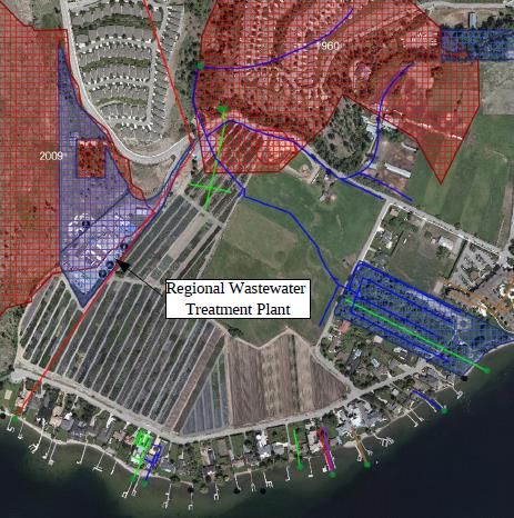
ii
Executive Summary

The Community Wildfire Protection Plan (CWPP) has been a foundational element of the
Strategic Wildfire Prevention Initiative (SWPI), and now the Community Resiliency Investment
(CRI) program and serves to paint the complete wildfire picture for communities in British
Columbia. Since completion of their first CWPP in 2009, the City of West Kelowna has
experienced continued community growth and expansion. Flowing from the original CWPP have
been numerous fuel hazard mitigation treatments, as well as the continued occurrence of
wildfires. To reframe the wildfire issues faced by the community, and to position the municipality
to make continued use of mitigation funding under CRI, the City retained Davies Wildfire
Management Inc. to undertake an updated CWPP.

As a partial indicator of potential future wildfire activity, a fire history analysis was completed.
Although the occurrence rate of wildfires within the West Kelowna area of interest (AOI) has
shown a steady decline over the past few decades, the annual area burned indicates an opposite
trend. In other words, fewer wildfires are occurring in the AOI, but those that do occur are
generally burning more area.

Geospatial analysis of provincial fuel type layers and the provincial strategic threat analysis (PSTA)
outputs further characterize the wildfire threats that West Kelowna continues to face. Ongoing
fuel management efforts on public land is warranted, however continued emphasis needs to be
placed on the responsibilities of private property holders to manage their fuel hazards. This
includes residential property owners and the steps they can take to manage their landscaping
and structure characteristics to make their homes less ignitable during a wildfire.

On the response side of the wildland urban interface (WUI) fire equation, West Kelowna Fire
Rescue (WKFR) could be provided with augmented capabilities, in the form of an investment in a
‘side-by-side’, wildland fire-specific high-pressure pumps, tactical water tenders, a slip tank unit
and a Type 2 structure protection unit (SPU). Although enhanced response capabilities will
certainly help, they by no means decrease or absolve the responsibility that private property
owners have in taking proactive measures to improve WUI fire outcomes.

                                                  iii
West Kelowna will continue to face wildfire pressures, and these should be expected to increase
in a changing climate. By maintaining a proactive focus on wildfire mitigation and response
efforts, and through continued advocacy at the local and provincial levels, the community can
continue to find ways to grow and thrive in an active wildfire environment.

                                               iv
Summary of CWPP Recommendations
Table 1 Summary of CWPP recommendations. Note: CRI = Community Resiliency Investment program; CWK = City of West
Kelowna; BCWS = BC Wildfire Service; FLNRORD = Ministry of Forests, Lands, Natural Resource Operations & Rural Dev.

                                                           v
vi
vii
viii
Contents
Executive Summary.........................................................................................................................iii
Summary of CWPP Recommendations ............................................................................................v
List of Tables ................................................................................................................................... xi
List of Figures ................................................................................................................................. xii
1      Introduction ............................................................................................................................. 1
     1.1      Purpose............................................................................................................................. 1
     1.2      CWPP Planning Process .................................................................................................... 2
2.     Local Area Description ............................................................................................................. 2
     2.1      CWPP Area of Interest ...................................................................................................... 3
     2.2      Community Description ................................................................................................... 3
       2.2.1         Governance and Administration ............................................................................... 3
       2.2.2         Infrastructure and Services ....................................................................................... 4
       2.2.3         Economic Drivers ...................................................................................................... 4
       2.2.4         Land Ownership ........................................................................................................ 6
       2.2.5         Firefighting Jurisdiction ............................................................................................. 6
       2.2.6         Existing Evacuation and Egress Routes ..................................................................... 6
     2.3      Past Wildfires, Evacuations and Impacts ......................................................................... 7
     2.4      Current Community Engagement .................................................................................... 8
     2.5      Linkages to Other Plans and Polices................................................................................. 8
       2.5.1         Local Authority Emergency Plan ............................................................................... 8
       2.5.2         Affiliated CWPPs ....................................................................................................... 8
       2.5.3         Local Government and First Nation Plans and Policies ............................................ 8
       2.5.4         Higher Level Plans and Relevant Legislation............................................................. 9
       2.5.5         Ministry or Industry Plans ....................................................................................... 10
3.     Values at Risk ......................................................................................................................... 12
     3.1      Human Life and Safety ................................................................................................... 12
     3.2      Critical Infrastructure ..................................................................................................... 12
                                                                         ix
3.2.1 Electrical Power ...................................................................................................... 15
3.2.2 Communications, Pipelines and Municipal Buildings ............................................. 17
3.2.3 Water and Sewage .................................................................................................. 18
3.3 High Environmental and Cultural Values ....................................................................... 19
3.3.1 Drinking Water Supply Area and Community Watersheds .................................... 19
3.3.2 Cultural Values ........................................................................................................ 20
3.3.3 High Environmental Values ..................................................................................... 20
3.4 Other Resource Values ................................................................................................... 21
3.5 Hazardous Values ........................................................................................................... 22
4. Wildfire Threat and Risk ........................................................................................................ 22
4.1 Fire Regime, Fire Danger Days and Climate Change ...................................................... 22
4.1.1 Fire Regime ............................................................................................................. 22
4.1.2 Fire Weather Rating ................................................................................................ 24
4.1.3 Climate Change ....................................................................................................... 30
4.2 Provincial Strategic Threat Analysis (PSTA) .................................................................... 34
4.2.1 PSTA Final Wildfire Threat Rating ........................................................................... 34
4.2.2 Spotting Impact ....................................................................................................... 34
4.2.3 Head Fire Intensity .................................................................................................. 35
4.2.4 Fire History .............................................................................................................. 36
4.3 Local Wildfire Threat Assessment .................................................................................. 40
Fuel Type Verification ............................................................................................. 40
Proximity of Fuel to the Community....................................................................... 43
Fire Spread Patterns................................................................................................ 44
Topography ............................................................................................................. 45
4.4 Summary of Section 4 Recommendations ..................................................................... 47
5. Risk Management and Mitigation Factors ............................................................................ 47
5.1 Fuel Management .......................................................................................................... 48
5.2 FireSmart Planning and Activities .................................................................................. 52
xFireSmart Goals and Objectives .............................................................................. 52
Key Aspects of FireSmart for Local Governments .................................................. 53
Priority Areas within the Area of Interest for FireSmart ........................................ 55
5.3 Community Communication and Education .................................................................. 57
5.4 Summary of Section 5 Recommendations ..................................................................... 57
6. Wildfire Response Resources ................................................................................................ 59
6.1 Local Government and First Nation Firefighting Resources .......................................... 59
Fire Department and Equipment ............................................................................ 60
Operational Preparedness Plan .............................................................................. 62
Water Availability for Wildfire Suppression ........................................................... 64
Access and Evacuation ............................................................................................ 65
Training ................................................................................................................... 66
6.2 Structure Protection ....................................................................................................... 66
6.3 Summary of Section 6 Recommendations ..................................................................... 67
7. References ............................................................................................................................. 70
APPENDIX 1: Wildfire Threat Assessment – FBP Fuel Type Change Rationale ............................. 76
APPENDIX 2: Wildfire Threat Assessment Worksheets and Photos ............................................. 77
APPENDIX 3: Maps ........................................................................................................................ 78
APPENDIX 4: GIS Methodology ..................................................................................................... 79
List of Tables
Table 1 Summary of CWPP recommendations.. ..............................................................................v
Table 2 Land ownership types within the West Kelowna area of interest (AOI). .......................... 6
Table 3 Significant wildland urban interface fires in West Kelowna since 1992 ............................ 7
Table 4 Wildfire references in the Okanagan Shuswap Land and Resource Management Plan . 10
Table 5 Key municipal buildings in West Kelowna ....................................................................... 18
Table 6 Primary water systems in West Kelowna ......................................................................... 19
xiTable 7 Community watersheds in relation to the West Kelowna AOI ........................................ 20
Table 8 Red and Blue listed species and ecosystem communities in the West Kelowna AOI ..... 21
Table 9 Natural disturbance type classification in British Columbia ............................................ 23
Table 10 Summary of Fire Danger Class IV and V days for regional fire weather stations.. ........ 30
Table 11 Head fire intensity classes and associated fire behaviour ............................................. 36
Table 12 Distribution of CFFDRS fuel types in the West Kelowna AOI ......................................... 42
Table 13 Fuel type categories and crown fire spotting potential ................................................. 42
Table 14 Proximity to the Interface .............................................................................................. 43
Table 15 Suggested primary fuel breaks, as identified on Map 8 (Appendix 3) ........................... 50
Table 16 Fuel treatment summary table, as identified in Map 8 (Appendix 3) ........................... 51
Table 17 FireSmart practices and activities .................................................................................. 55
Table 18 Summary of completed and recommended FireSmart projects. .................................. 56
Table 19 West Kelowna Fire Rescue apparatus complement ...................................................... 61
Table 20 Possible operational preparedness scheme whereby Preparedness Level is influenced
by Fire Danger Class at the West Kelowna fire weather station. ................................................. 63
Table 21 Preparedness Conditions related to each proposed Preparedness Level.. ................... 64
List of Figures
Figure 1 Employed labour force in West Kelowna ......................................................................... 5
Figure 2 Powers Creek Water Treatment Plant in relation to historical wildfires ....................... 13
Figure 3 Regional Wastewater Treatment Plant in relation to historical wildfires ...................... 14
Figure 4 Rose Valley reservoir and location of future water treatment plant ............................. 15
Figure 5 Westbank Substation and IL244 transmission line in relation to historical wildfires .... 17
Figure 6 BC Wildfire Service fire weather stations in the West Kelowna region ......................... 25
Figure 7 Fire Danger Class methodology ...................................................................................... 26
Figure 8 Brenda Mines Fire Danger Class IV and V report ............................................................ 28
Figure 9 Fintry Fire Danger Class IV and V report ......................................................................... 28
Figure 10 Penticton Fire Danger Class IV and V report................................................................. 29
xiiFigure 11 West Kelowna Fire Danger Class IV and V report for 2017 .......................................... 29
Figure 12 Range of projected Summer (June, July, August) temperature change ....................... 32
Figure 13 Range of projected Summer (June, July, August) precipitation change ....................... 33
Figure 14 Annual wildfire occurrence and annual area burned in AOI, 1950 to 2017 ................. 38
Figure 15 Annual area burned in the West Kelowna AOI since 1922 ........................................... 39
Figure 16 Total distribution of wildfire occurrence by month, 1950 to 2017 .............................. 39
Figure 17 Wind rose for the West Kelowna area.......................................................................... 45
Figure 18 Relative slope position of values .................................................................................. 46
xiiiWEST KELOWNA COMMUNITY WILDFIRE PROTECTION PLAN – 2018 UPDATE
1 Introduction
The Community Wildfire Protection Plan (CWPP) program was initiated by the Province of British
Columbia as a response to key recommendations contained in the Firestorm 2003 Provincial
Review (Filmon, 2004). The CWPP program has been administered by the Union of BC
Municipalities (UBCM) as a foundational component of the overarching Strategic Wildfire
Prevention Initiative (SWPI) suite of funding programs since 2004 (Union of BC Municipalities,
2018). Recently, the provincial government announced that SWPI programs and funding would
be rolled into the Community Resiliency Investment (CRI) program (BC Government News, 2018).
The CWPP program continues to be available to all local governments and First Nations in BC
(Union of BC Municipalities, 2018).
Most preexisting CWPPs in the province are going through their first update since the beginning
of the initiative. The City of West Kelowna (West Kelowna) completed its first CWPP in March
2009. To refresh the wildfire perspective and be able to continue accessing mitigation funding,
West Kelowna retained the consulting services of Davies Wildfire Management Inc. to conduct a
comprehensive update to the CWPP.
1.1 Purpose
A CWPP is intended to provide the basis for all future wildfire mitigation actions in a community.
As such, the content of a CWPP provides a clear description of the wildfire environment, wildfire
risks to the community, as well as strategic and operational recommendations to reduce risk and
increase the community’s resilience to wildfire threats.
A comprehensive awareness of the factors of the wildfire environment is the foundation upon
which future hazard identification and mitigation efforts can proceed. In the intervening years
since the adoption of the most recent CWPP, the regional and provincial wildfire picture has come
into greater focus. Several high-profile wildland urban interface (WUI) fires have since impacted
the community and surrounding area. Further afield, significant wildfire disasters have occurred
in other parts of Western Canada.
1WEST KELOWNA COMMUNITY WILDFIRE PROTECTION PLAN – 2018 UPDATE
With these persistent factors in mind, the CWPP remains a cornerstone of wildfire mitigation for
communities. The intended outcome of the CWPP planning process is to provide the community
with a detailed framework to further efforts that will:
• Reduce the likelihood of a wildfire entering the community;
• Reduce the impacts and/or losses to property and critical infrastructure;
• Reduce negative economic and social wildfire impacts to the community.
1.2 CWPP Planning Process
The CWPP planning process for West Kelowna has been simplified by the pre-existing interest
and prior work undertaken by the city in the areas of wildfire mitigation, education and advocacy.
West Kelowna is in the advantageous position of having gone through the CWPP process roughly
10 years ago, and has since diligently undertaken several SWPI projects, public education and
FireSmart initiatives. As a proactive and forward-thinking community, West Kelowna has
emerged as a leading organization among local governments in the field of wildland urban
interface firefighting operations and hazard mitigation. These characteristics serve to facilitate
and simplify the CWPP update process.
Davies Wildfire Management Inc. (DWM) was retained as the consulting firm to conduct the
CWPP update. Andrew Low, RPF, and John Davies, RPF, supervised the field assessments, analysis
and report compilation as forest professionals qualified in all aspects of wildland fire
management.
DWM worked closely with key staff from West Kelowna, including West Kelowna Fire Rescue
Assistant Chief Brent Watson, who manages the fire prevention program for the city.
2. Local Area Description
West Kelowna is a growing municipality, with a relatively recent history, in the heart of the
Okanagan Valley. The Syilx thrived in the region for thousands of years. Following European
settlement in the mid to late 1800s, the Westside area of Okanagan Lake existed mainly as an
unincorporated community. Much of the area was governed under the Regional District of
2WEST KELOWNA COMMUNITY WILDFIRE PROTECTION PLAN – 2018 UPDATE
Central Okanagan from 1967 to 2007. Following several governance adjustments, studies and
referenda, in 2007, the most densely populated areas of the community incorporated to become
what is now known as the City of West Kelowna.
West Kelowna enjoys a close partnership with the Westbank First Nation (WFN). Westbank First
Nation is comprised of five reserves, with Tsinstikeptum Reserves 9 and 10 bordering Okanagan
Lake and West Kelowna. Westbank First Nation is unique from most First Nations across Canada,
as WFN Lands are not governed under the Indian Act. Rather, WFN Lands are governed under a
comprehensive set of community laws, with full jurisdictional control over its resources and
lands, as defined under the WFN Self Government Agreement.
2.1 CWPP Area of Interest
The area of interest (AOI), as used in CWPP terminology, essentially describes the study area. The
UBCM guidance for defining the AOI is rather flexible, ranging from simply the extent of wildland
urban interface (WUI) as the minimum, to taking a wider view consisting of the local
government’s legal boundary, with an added 2 km buffer beyond.
West Kelowna has a relatively substantial proportion of Crown land within its legal boundary,
therefore, for the purpose of the CWPP, the AOI has been defined as the legal boundary, plus a
2-km buffer. The proportions of land ownership (Crown, municipal, private etc.) will be different
than what is published in West Kelowna corporate information, owing to the inclusion of the 2-
km buffer in the AOI delineation.
2.2 Community Description
2.2.1 Governance and Administration
West Kelowna has gone through several governance adjustments in the past few decades. Prior
to 2007, the community was part of a rural electoral area governed by the Regional District of
Central Okanagan (RDCO), before being incorporated as Westside District Municipality on
December 6, 2007. The municipality’s name was changed in 2008 to the District of West Kelowna.
This name remained until June 26, 2015 when the district municipality was reclassified to a city,
3WEST KELOWNA COMMUNITY WILDFIRE PROTECTION PLAN – 2018 UPDATE
under the name, City of West Kelowna. Governance of West Kelowna is under a Mayor and
Council, consisting of six councilors (City of West Kelowna, 2018).
The Syilx people have inhabited the Okanagan Valley for thousands of years. Currently, the
Westbank First Nation (WFN) is one of eight communities within the Okanagan Nation. West
Kelowna neighbours two of the five WFN reserves, Tsinstikeptum Reserves 9 and 10, respectively.
Owing to their proximity and mutual benefit, West Kelowna provides fire protection service to
WFN, via West Kelowna Fire Rescue.
2.2.2 Infrastructure and Services
Electricity service for West Kelowna is provided by BC Hydro via the 1L244 (138 kV) transmission
line between the Nicola and Westbank substations (BC Hydro, 2016). The West Kelowna
Transmission Project (WKTP) is a multi-year BC Hydro project to build a secondary transmission
line to the Westbank Substation (BC Hydro, 2018). Currently, BC Hydro has identified one of three
alternative routes (Alternative 2: to Nicola Substation) as the leading alternative. The intended
route would not parallel the existing route; rather, it would follow a different route to limit the
probability of a wildfire or landslide from impacting both transmission lines, thus achieving a
redundant supply (BC Hydro, 2018).
West Kelowna is in the Okanagan health service area of the Interior Health Authority (IHA). West
Kelowna is served by the Kelowna General Hospital (KGH), which provides high-level, specialty
medical care, including 24-hour emergency and trauma services, as well as specialized services,
including cardiac surgery (Interior Health, 2018). The West Kelowna Health Centre provides the
community with urgent and outpatient ambulatory care, as well as basic laboratory and radiology
services (Interior Health, 2018).
2.2.3 Economic Drivers
The 2016 Census employment data provide an indication of the economic drivers in West
Kelowna. As illustrated in Figure 1, the top four sectors (retail; healthcare; construction; and
accommodation/food services) account for nearly half (46.2%) of the employed labour force in
West Kelowna (Government of Canada, 2016).
4WEST KELOWNA COMMUNITY WILDFIRE PROTECTION PLAN – 2018 UPDATE
These top sectors can be particularly sensitive to the impacts of wildfire on the region. For
example, evacuations and smoke impacts, whether they are affecting the community directly or
the indirect effect of negative perception among potential visitors regarding fires elsewhere in
the province can all lead to a decrease in visitation and tourist spending (Deacon, 2017). Wildfire
smoke also contributes to increased health concerns among susceptible populations, resulting in
increased strain on health care facilities (HealthLinkBC, 2017).
Employed labour force aged 15 and over by industry sectors, West
Kelowna, 2016
Retail trade
Health care and social assistance
Construction
Accommodation and food services
Professional, scientific and technical services
Manufacturing
Educational services
Other services (except public administration)
Administrative and support, waste management and…
Public administration
Transportation and warehousing
Finance and insurance
Wholesale trade
Real estate and rental and leasing
Arts, entertainment and recreation
Agriculture, forestry, fishing and hunting
Information and cultural industries
Mining, quarrying, and oil and gas extraction
Utilities
Management of companies and enterprises
0 2 4 6 8 10 12 14 16
Distribution (%)
Figure 1 Employed labour force in West Kelowna.
5WEST KELOWNA COMMUNITY WILDFIRE PROTECTION PLAN – 2018 UPDATE
2.2.4 Land Ownership
The West Kelowna AOI is comprised of 67% Crown land and 24% private property. The remainder
is First Nation reserve and other land, regional and municipal parks and municipal land.
Table 2 Land ownership types within the West Kelowna area of interest (AOI).
Type Area (ha) %
Crown (Provincial or Crown Agency) 16568 66.6%
Private 6000 24.1%
First Nation or Indian Reserve 1062 4.3%
Park (Municipal or Regional) 791 3.2%
None or Unknown 436 1.8%
Municipal 29 0.1%
24885 100.0%
2.2.5 Firefighting Jurisdiction
Fire protection for West Kelowna and Westbank First Nation is carried out by West Kelowna Fire
Rescue – a fire department composed of both professional fulltime and paid-on-call volunteers
(City of West Kelowna, 2014). An operational profile of WKFR is provided in Section 6.
2.2.6 Existing Evacuation and Egress Routes
West Kelowna has identified an alternate evacuation route for the Glenrosa neighbourhood, via
the Jackpine and Bear Creek Forest Service Roads (FSR) to Westside Road, or to Highway 97C via
the Sunset Main FSR. The total distance from the Glenrosa Road/HWY 97 junction along the
6WEST KELOWNA COMMUNITY WILDFIRE PROTECTION PLAN – 2018 UPDATE
alternate evacuation route to Westside Road is approximately 49-km (City of West Kelowna,
2016).
2.3 Past Wildfires, Evacuations and Impacts
Wildfires have been a regular and natural disturbance agent in the Okanagan for millennia. The
recent past has seen the occurrence of several disruptive WUI fires in West Kelowna, that have
resulted in evacuations, damage to property and economic effects. A detailed fire history
analysis, including fire occurrence and annual area burned within the AOI is provided in Section
3. The most recently significant WUI fires in the AOI are summarized in Table 3.
Table 3 Significant wildland urban interface fires in West Kelowna since 1992.
7WEST KELOWNA COMMUNITY WILDFIRE PROTECTION PLAN – 2018 UPDATE
2.4 Current Community Engagement
West Kelowna Fire Rescue has an active public education program and holds regular education
and outreach events on topics ranging from chimney fire safety, fire extinguishers, car seat
safety, smoke alarms, and WUI safety, among others. In 2016, WKFR and WFN held their first
Family FireSmart Day and had over 1,000 people in attendance. The WKFR prevention program
has a dedicated Fire and Life Safety Educator that works to further the department’s public
education goals (City of West Kelowna, 2014 ).
2.5 Linkages to Other Plans and Polices
2.5.1 Local Authority Emergency Plan
West Kelowna is party to the Regional District of Central Okanagan Emergency Plan, which is
coordinated by the City of Kelowna on behalf of the regional district, the District of Lake Country,
the District of Peachland, Westbank First Nation, Kelowna and West Kelowna (City of Kelowna,
2016). The emergency plan is intended to:
• assist emergency personnel to respond to disasters and major emergencies, such as
floods, wildfires, major spills, plane crashes etc.;
• establish a centralized assessment and decision-making organization to share regional
resources or request assistance from the provincial or federal governments;
• guide post-emergency recovery operations.
2.5.2 Affiliated CWPPs
Adjacent jurisdictions with CWPPs are the District of Peachland (Davies, et al., 2012), the City of
Kelowna (Pashkowski & Blackwell, 2016) and the Regional District of Central Okanagan
(Blackwell, 2010). Both the District of Peachland and the Regional District of Central Okanagan
will have AOIs that overlap with the West Kelowna AOI. Joint projects are certainly possible,
especially in Regional Parks or areas of overlap with Peachland.
2.5.3 Local Government and First Nation Plans and Policies
8WEST KELOWNA COMMUNITY WILDFIRE PROTECTION PLAN – 2018 UPDATE
Wildfire planning and mitigation requirements figure prominently in the West Kelowna Official
Community Plan. West Kelowna has established seven development permit areas (DPAs),
including DPA 7 – Wildfire Interface, which is intended to:
• regulate development to protect life and property from wildfire hazard;
• reduce the susceptibility to wildfire of new construction or large additions near the
provincial forest interface, or the interface with large forested parks;
• encourage wildfire hazard reduction methods that support the restoration of the natural
environment, such as thinning and spacing trees and vegetation, removal of debris and
dead material from the ground, removal of lower tree branches and using fire as a fuel
management tool, and;
• support measures designed to improve forest health on Crown lands (e.g. tree spacing,
control of pine beetle) and encourage complementary measures on rural lands adjacent
to provincial forests (City of West Kelowna, 2011).
Westbank First Nation does not have their own dedicated CWPP but have received funding to
carry out fuel management prescriptions and treatments, as well as a recent FireSmart project.
The wildfire management work that the WFN undertakes has an inherent benefit to the City of
West Kelowna, and vice versa. To this end, the WKFR continues to provide in-kind support for
ongoing WFN mitigation projects, above and beyond the formal provision of fire protection
services.
2.5.4 Higher Level Plans and Relevant Legislation
The Okanagan Shuswap Land and Resource Management Plan (LRMP) was completed in 2001
and relates to Crown land throughout the Okanagan Shuswap Natural Resource District (Province
of British Columbia, 2001). The LRMP makes several references to wildfire management and
hazard reduction (Table 4), none of which impinge on the ability of local governments to
undertake mitigation work. Flowing from the LRMP are orders pertaining to the establishment of
resource management zones and old growth management objectives (Province of British
Columbia, 2007) and none of these orders impede West Kelowna from pursuing strategic wildfire
mitigation efforts.
9WEST KELOWNA COMMUNITY WILDFIRE PROTECTION PLAN – 2018 UPDATE
Table 4 Wildfire references in the Okanagan Shuswap Land and Resource Management Plan (Province of British Columbia,
2001).
2.5.5 Ministry or Industry Plans
10WEST KELOWNA COMMUNITY WILDFIRE PROTECTION PLAN – 2018 UPDATE
The Ministry of Forests, Lands, Natural Resource Operations and Rural Development (FLNRORD)
has prepared fire management plans for each Natural Resource District in the province, as
required by ministry policy. Fire management plans are intended to address all wildfire-related
issues within the natural resource district, particularly the desired interaction between resource
management concerns and fire suppression requirements. It is important to note that district fire
management plans are currently not public documents. For the purposes of this CWPP update,
the authors were afforded the opportunity to view the plan.
The current fire management plan for the Okanagan Shuswap Natural Resource District dates
from 2015 and carries forward the 2014 wording with updates to spatial data only. The district
fire management plan is a brief 15-page document that also includes high-level district mapping
according to four broad “priority themes”. The mapping themes are as follows:
• Theme 1 – Human Life and Safety
o WUI areas (high, moderate and low structure density)
o Evacuation routes and marshalling points
• Theme 2 – Critical Infrastructure and Property (that relates to maintaining Theme 1)
o Energy generation and transmission, healthcare, first responder facilities,
transportation, wildland structures etc.
• Theme 3 – High Environmental Cultural
o Water resources, species at risk, cultural values
• Theme 4 – Resource Values
o Ungulate winter range, old-growth management areas, timber, silviculture
investments, range management, and visual quality areas
The Westbank First Nation has a Community Forest Agreement (K1P) that includes Crown land
area within the West Kelowna municipal boundary. The current Forest Stewardship Plan (FSP)
guides the forestry practices on the community forest and replaceable forest license, and
identifies the application of the fire management stocking standards (Chief Forester, 2016) within
2-km of the WUI (Gill, 2017). The existence of a long-term area-based tenure within and adjacent
11WEST KELOWNA COMMUNITY WILDFIRE PROTECTION PLAN – 2018 UPDATE
to the West Kelowna AOI will continue to provide opportunities to undertake mutually beneficial
wildfire hazard mitigation for both the WFN and West Kelowna.
3. Values at Risk
3.1 Human Life and Safety
The most recent census data from the Government of Canada indicates an enumerated
population for West Kelowna of 32,655 – up 5.7% from the 2011 census. The 2016 census also
indicates 12,437 occupied private dwellings in West Kelowna, an increase of 5.3% from 2011.
With a land area of 123.53 square kilometers, the population density of West Kelowna is 264.4
people per square kilometer (Government of Canada, 2016).
Bear Creek Provincial Park is outside the municipal boundary but inside the AOI. West Kelowna
Fire Rescue has been involved in several wildfire incidents that have impacted Bear Creek Park,
including the evacuation of campers (see Table 3). Bear Creek Park is a popular location for
camping, day-use and boating, bringing 221,265 person-days of attendance in fiscal year 2015-
16 (Ministry of Environment, 2016). Established in 1981, Bear Creek Park is 178 ha with 122
campsites available during the camping season that runs from April to October (Ministry of
Environment, 2018).
3.2 Critical Infrastructure
The Powers Creek Water Treatment Plant (WTP) was commissioned in 2007 by the Westbank
Irrigation District, which was later dissolved, and operations transferred to the West Kelowna
municipality in 2011 (City of West Kelowna, 2016). The 2014 Smith Creek Fire burned near of the
water treatment plant, as did a historical wildfire that occurred in 1935 (Figure 2). The
implications of a wildfire impacting the Powers Creek WTP are significant: The Westbank System
serves over 4,350 residential, commercial and industrial connections, representing a total
population served of approximately 13,000 people. These users consume approximately 5,300
mega liters of water annually (City of West Kelowna, 2011).
12WEST KELOWNA COMMUNITY WILDFIRE PROTECTION PLAN – 2018 UPDATE
Figure 2 Powers Creek Water Treatment Plant in relation to historical wildfires.
The Westside Regional Wastewater Treatment Plant is located on Gellatly Road and serves the
communities of West Kelowna, Peachland and WFN Reserves 9 and 10 (RDCO, 2010). The original
treatment plant was commissioned in 1989, with the current plant beginning operation in 2012.
The facility treats an average of 10 million litres of wastewater daily and is currently undergoing
a project to expand the outfall into Okanagan Lake (RDCO, 2018). The 2009 Glenrosa Fire burned
right up to the treatment plant (Figure 3) and damaged several wood power poles. The
implications of service interruption of the plant are significant, as the plant treats wastewater for
approximately 47,111 people, as enumerated in the 2016 census (Government of Canada, 2016).
13WEST KELOWNA COMMUNITY WILDFIRE PROTECTION PLAN – 2018 UPDATE
Figure 3 Regional Wastewater Treatment Plant in relation to historical wildfires.
The Rose Valley Reservoir is the primary water source for the Lakeview Water System (City of
West Kelowna, 2011). A major project to construct the Rose Valley Water Treatment Plant is
planned, with a target date of construction for 2021 (City of West Kelowna, 2017). The new plant
would continue to serve the Lakeview System, with future expansion to supply the entire north
half of the city. The 2009 Rose Valley Fire burned down to the shoreline on the southwest portion
of the reservoir (Figure 4). The planned Rose Valley plant is slated to be wildfire and earthquake
resistant (City of West Kelowna, 2017).
14WEST KELOWNA COMMUNITY WILDFIRE PROTECTION PLAN – 2018 UPDATE
Figure 4 Rose Valley reservoir and location of future water treatment plant in relation to historical wildfire.
3.2.1 Electrical Power
Electricity is supplied to West Kelowna via the BC Hydro 1L244 transmission line (130kV), from
Nicola to Westbank Substations (BC Hydro, 2016). The Westbank Substation is located within
West Kelowna on Shannon Lake Road, adjacent to Tsinstikeptum Reserve 9. The 2014 Smith
Creek Fire burned up to a portion of the 1L244 right-of-way opening (Figure 5). The West Kelowna
Transmission Project (WKTP) is intended to supply a redundant transmission system to the
Westbank Substation (BC Hydro, 2018). At present, the leading alternative route for the WKPT is
Transmission Alternative 2: to Nicola Substation.
A wildfire risk assessment has been completed for BC Hydro. This assessment examined three
alternative transmission routes for the WKTP and found Alternative 2 as having a lower fire
15WEST KELOWNA COMMUNITY WILDFIRE PROTECTION PLAN – 2018 UPDATE
probability and associated risk (Blackwell, 2016). Although not entirely within the scope of this
CWPP update, the author would be remiss not to offer comment on the potential implications of
Alternative 2 in relation to West Kelowna.
One factor is the creation of additional infrastructure that would require a firefighting response
in the event of a threatening wildfire occurrence. Conceivably, as the separation between the
Alternative 2 route and the existing 1L244 circuit decreases with increasing proximity to the
Westbank Substation, the redundancy of the second transmission line would hinge on the
successful suppression and containment of a wildfire. This situation may result in added
pressures on the WKFR as they operate in an already active wildfire environment.
Although the WKTP concept is to maintain enough separation between 1L244 and Alternative 2
to minimize the chance of a wildfire simultaneously impacting both lines, the possibility of such
an occurrence cannot be completely discounted, as stated by Blackwell (2016). Similarly, the
possibility of multiple ignitions in the 1L244/Alternative 2 area (during a dry-lightning event, for
example) leading to coincident wildfires impacting both lines cannot be discounted. Whichever
alternative route is selected, consideration must be given to the operational impacts that may
placed on the firefighting capacity of WKFR.
16WEST KELOWNA COMMUNITY WILDFIRE PROTECTION PLAN – 2018 UPDATE
Figure 5 Westbank Substation and 1L244 transmission line in relation to historical wildfires.
3.2.2 Communications, Pipelines and Municipal Buildings
The following infrastructure are noted:
• West Kelowna has several TELUS Mobility and Rogers Communications cellular towers
serving the area (Nikkel, 2018).
• Transmission pipeline for natural gas, runs through West Kelowna and across Okanagan
Lake to Kelowna (FortisBC, 2009). FortisBC has a corporate emergency response plan for
pipeline and electrical emergencies (FortisBC, 2016).
• Key municipal buildings in West Kelowna are summarized below (City of West Kelowna,
2016).
17WEST KELOWNA COMMUNITY WILDFIRE PROTECTION PLAN – 2018 UPDATE
Table 5 Key municipal buildings in West Kelowna.
3.2.3 Water and Sewage
West Kelowna has five main water systems serving most city residents (Table 6). The Lakeview
System is primarily fed by the Rose Valley Reservoir, while the Pritchard, Sunnyside and West
Kelowna Estates Systems draw water from Okanagan Lake. The Westbank System is supplied by
the Powers Creek Water Treatment Plant (City of West Kelowna, 2016). Community watersheds
that feed the various water systems are listed in section 3.3.1.
18WEST KELOWNA COMMUNITY WILDFIRE PROTECTION PLAN – 2018 UPDATE
Sewage treatment for West Kelowna is handled by the Westside Regional Wastewater Treatment
Plant, operated by the Regional District of Central Okanagan, as detailed in section 3.2.
Table 6 Primary water systems in West Kelowna.
3.3 High Environmental and Cultural Values
3.3.1 Drinking Water Supply Area and Community Watersheds
Two community watersheds are located within the West Kelowna municipal boundary and two
additional watersheds are located within the AOI. The Rose Valley community watershed is
entirely within the West Kelowna municipal boundary and feeds the Rose Valley Reservoir, in
turn supplying the Lakeview Water System. The Lambly community watershed is also tied to the
Rose Valley Reservoir, with a portion of the watershed lying within the AOI. Most water drawn
by the Westbank Water System is from the Powers community watershed, which occupies a
portion of the West Kelowna municipal area. Minor amounts of water are also drawn from the
Lambly and Nicola community watersheds (City of West Kelowna, 2016). A portion of the
Trepanier community watershed lies within the AOI but does not feed into the West Kelowna
19WEST KELOWNA COMMUNITY WILDFIRE PROTECTION PLAN – 2018 UPDATE
water system. The community watersheds pertaining to the West Kelowna AOI are summarized
in Table 7.
Table 7 Community watersheds in relation to the West Kelowna AOI.
3.3.2 Cultural Values
Due to an extensive and ongoing First Nation presence, wildfire suppression operations have the
potential to seriously impact or destroy cultural heritage resources. It can be challenging to
navigate the requirements of the Heritage Conservation Act (HCA) during the critical initial attack
phase of a wildfire response, but a basic awareness on what to look for can help to ensure that
cultural heritage resources aren’t impacted by suppression actions. For good reason, the exact
locations of known resources are often privileged information, but through agreement and trust,
general information regarding areas could be shared. From there, it is incumbent on personnel
who are actively working in the field to be able to identify resources so that suppression actions
can be planned or altered in such a way as to not to contravene the HCA.
3.3.3 High Environmental Values
The BC Conservation Data Centre identifies Blue and Red listed vertebrate animals and ecosystem
communities within the West Kelowna AOI, as summarized in Table 8 (BC Conservation Data
Centre, 2018). A review of DataBC layers indicates that no fisheries-sensitive watersheds are
within the AOI.
20WEST KELOWNA COMMUNITY WILDFIRE PROTECTION PLAN – 2018 UPDATE
Table 8 Red and Blue listed species and ecosystem communities within the West Kelowna AOI.
3.4 Other Resource Values
The Westbank First Nation entered into a five-year Community Forest Pilot Agreement in 2004,
which was solidified into a 25-year (replaceable every 10-years) Community Forest Agreement
(CFA) in 2009 (NTITYIX Resources, 2004). The CFA is composed of two blocks; one directly west
of West Kelowna and the other to the northwest of Big White. The entire CFA is over 46,000-ha
and the 2015/16 harvest level was 74,264 m3 on a net area of 330.5-ha (NTITYIX Resources, 2016).
21WEST KELOWNA COMMUNITY WILDFIRE PROTECTION PLAN – 2018 UPDATE
3.5 Hazardous Values
West Kelowna is not characterized by extensive heavy industry and the potentially hazardous
materials associated with such. The extent of the hazardous materials found within the municipal
boundaries are characteristic of many other communities. These include gas stations, natural gas
utilities, water treatment chemicals, arena refrigeration systems and agricultural inputs.
4. Wildfire Threat and Risk
4.1 Fire Regime, Fire Danger Days and Climate Change
The Okanagan Valley is an active fire environment where conditions often exist during the
summer months where there is potential for losses to the public. When assessing the wildfire
situation of the region, past conditions offer an indication of potential future conditions in the
near term, and climate change scenarios must be incorporated to increase future resilience.
4.1.1 Fire Regime
The ecology of the West Kelowna AOI has been shaped by the frequent occurrence of frequent
low-intensity, stand-maintaining natural and historical anthropogenic fires. The majority of the
AOI is classified as Natural Disturbance Type 4 (NDT4), while a small portion (approximately 5%)
is classified as NDT3. The NDT classification (Table 9) of an area provides an illustration of the
magnitude and frequency of natural disturbance (wildfires and windstorms, predominantly)
across the land base.
22WEST KELOWNA COMMUNITY WILDFIRE PROTECTION PLAN – 2018 UPDATE
Table 9 Natural disturbance type classification in British Columbia.
In terms of natural disturbance, a distinction is drawn between stand-initiating and stand-
maintaining events. Stand-initiating events typically terminate the existing forest and induce
secondary succession to produce a new forest. Stand-maintaining events serve to keep
successional processes stable (Province of British Columbia, 1995). In wildfire terms, high
intensity fire behaviour, such as intermittent or continuous crown fire, would be considered a
stand-initiating event. Conversely, a low intensity fire surface fire consuming understory fuels
while retaining a mature overstory is considered a stand-maintaining event.
These distinctions are important when assessing the wildfire history of an area. The absence of
frequent stand-maintaining processes can result in a cascading series of ecological responses,
including forest health, habitat and fuel loading issues. In the NDT4, low-intensity (i.e. surface
fire) fire return intervals historically ranged from 4 to 50 years (Province of British Columbia,
1995). Forest protection policies centered around aggressive fire suppression have resulted in a
drastically reduced frequency (or absence) of fire in ecosystems that are dependant (i.e.
maintained) by frequent, low-intensity surface fires.
Stand-initiating fires (i.e. crown fires) in Ponderosa pine dominated stands were historically rare,
with return intervals of at least 150 to 250+ years (Province of British Columbia, 1995). The longer
a fire-maintained stand goes without fire maintenance, the greater the likelihood that a future
fire occurrence will be a stand-initiating disturbance. From a firefighting standpoint this
23WEST KELOWNA COMMUNITY WILDFIRE PROTECTION PLAN – 2018 UPDATE
increasingly deteriorating condition can result in wildfires that require significantly more
suppression effort and cost to control.
4.1.2 Fire Weather Rating
Four BCWS fire weather stations were reviewed for the West Kelowna CWPP update, including
the new West Kelowna station installed in late 2016. The West Kelowna station provides the most
representative weather observations and data, however there is only one complete fire season
(2017) of data to analyze. The Penticton, Brenda Mines and Fintry fire weather stations were also
analyzed to provide a regional history of fire weather (Figure 6). As the West Kelowna station
continues to operate, a clearer representation of persistent and ongoing fire weather conditions
will emerge. The immediate benefits of the West Kelowna fire weather station include increased
situational awareness for wildfire preparedness for WKFR and BCWS firefighting resources and
better planning information for operational fuel management treatments.
24WEST KELOWNA COMMUNITY WILDFIRE PROTECTION PLAN – 2018 UPDATE
Figure 6 BC Wildfire Service fire weather stations in the West Kelowna region.
For the purposes of CWPPs in BC, fire weather conditions are described in terms of the Fire
Danger Class. Fire Danger Class is defined in the Wildfire Regulation and is a rating derived from
outputs of the Canadian Forest Fire Weather Index (FWI) System. Although the sole intent of the
Fire Danger Class rating scheme is to restrict high risk activities (primarily industrial) occurring on
or about forest and grassland areas, the use of Fire Danger Class has been extended to the CWPP
field as a straightforward means of characterizing fire weather conditions in an area represented
by a weather station.
Fire Danger Class is determined by comparing the Buildup Index (BUI) to the Fire Weather Index
(FWI) in one of three tables presented in the Wildfire Regulation. Each table is specific to one of
three broad Danger Regions in BC; West Kelowna is situated in Danger Region 3, along with the
Penticton, Brenda Mines and Fintry fire weather stations that were included in this analysis. The
25WEST KELOWNA COMMUNITY WILDFIRE PROTECTION PLAN – 2018 UPDATE
actual Fire Danger Classes are numerical ratings 1-5, in ascending order of severity. An illustration
of the various inputs and components from which Fire Danger Class is derived is presented in
Figure 7.
Figure 7 Fire Danger Class methodology.
A Fire Danger Class report for each of the four fire weather stations analysed has been prepared
(see Figures 8-11). The Fire Danger Class reports illustrate the number of days per year when the
Fire Danger Class was rated IV or V. In Danger Region 3 (where each of the stations are located),
Fire Danger Class IV and V occur within the following BUI and FWI ranges:
• BUI: 51 – 201+
• FWI: 17 – 47+
26WEST KELOWNA COMMUNITY WILDFIRE PROTECTION PLAN – 2018 UPDATE
For each of the stations, the average number of Fire Danger Class IV and V days in each dataset
is presented (see Table 10), as well as the median, maximum and year of maximum. As the West
Kelowna station is limited to one year of fire season data, the information is presented as a total
count of Fire Danger Class IV and V days. With the exception of the Penticton station (discussed
below), 2017 was the year of maximum number of Fire Danger Class IV and V days.
One peculiarity in the Penticton station data is the relatively frequent occurrence of Fire Danger
Class V days in the 1970s, when compared to more recent years. Although the entire Penticton
station dataset dates from 1970, the installation date for the station is listed as August 16, 1988
(Data BC, 2018 and PCIC, 2018). It is unknown (and unimportant for this particular purpose) as to
what specific location from which pre-1988 Penticton station data was obtained, but is important
to note in order to caution the reader as to the validity of this early portion of the dataset. Fire
weather data from the Penticton station have been analyzed for the period of 1988 to 2018,
although the entire dataset is presented in Figure 10.
Of interest is the increasing linear trend for Fire Danger Class IV and V days for the Brenda Mines
station. Although the Brenda Mines station is roughly 30-km away from the West Kelowna station
(Figure 6), and at an elevation of nearly 1,500-m, as opposed to the station elevation of 650-m
for West Kelowna, Brenda Mines is somewhat representative of the higher elevation western
portions of the West Kelowna AOI. For this reason, it will be important for West Kelowna to
include the Brenda Mines station in their operational fire weather situational awareness as an
indicator of the potential for high-elevation timber fires that could impact the community.
Similarly, the Fintry station shows an increasing linear trend for both classes, particularly Fire
Danger Class IV. Given the similar station elevations (Fintry is at 670-m in elevation), it would be
reasonable to assume that, had the West Kelowna station been in operation for a similar time
period, a comparable increasing trend would likely be evident. It would be possible to conduct a
retrospective analysis by interpolating between regional fire weather stations to create a
hypothetical dataset of past fire weather values to further characterize recent conditions.
Regardless, the instalation of the West Kelowna station is a timely addition to the provincial fire
weather network and it’s continued operation should be supported.
27WEST KELOWNA COMMUNITY WILDFIRE PROTECTION PLAN – 2018 UPDATE
Brenda Mines Danger Class IV and V Report
70
60
50
40
Days
30
20
10
0
1989
1977
1979
1981
1983
1985
1987
1991
1993
1995
1997
1999
2001
2003
2005
2007
2009
2011
2013
2015
2017
Year
Danger Class 4 Danger Class 5
Figure 8 Brenda Mines Fire Danger Class IV and V report.
Fintry Danger Class IV and V Report
100
90
80
70
60
Days
50
40
30
20
10
0
1991
2004
2017
1989
1990
1992
1993
1994
1995
1996
1997
1998
1999
2000
2001
2002
2003
2005
2006
2007
2008
2009
2010
2011
2012
2013
2014
2015
2016
2018
Year
Danger Class 4 Danger Class 5
Figure 9 Fintry Fire Danger Class IV and V report.
28You can also read