Planning Proposal Site specific amendment to Hurstville Local Environmental Plan 2012 - NSW Government
←
→
Page content transcription
If your browser does not render page correctly, please read the page content below

Repo

Planning Proposal
Site specific amendment to
Hurstville Local Environmental Plan 2012
Hurstville Civic Precinct
Hurstville NSW 2220
Submitted to Georges River Council
On Behalf of Georges River Council (Properties)

                                                                                                  July 2018 | 18-141
CITY PLAN STRATEGY & DEVELOPMENT P/L - PLANNING PROPOSAL: HURSTVILLE CIVIC PRECINCT - JULY 2018              1/100
Report Revision History
 Revision        Date Issued          Prepared by                Reviewed by                 Verified by
 01              16/07/18             Sonny Embleton             Helen Deegan
                                      Senior Associate           Director
                                      B Env Des UWA              Grad Dip, Urban             Helen Deegan
                                      Grad Dip Urb Des           Estate                      Director
                                      Curtin University          Management, UTS
                                                                                             Grad Dip, Urban
                                                                 B Town Planning,            Estate
                                                                 (Hons1) UNSW                Management, UTS
                                                                                             B Town Planning,
 02              30/07/18             Sonny Embleton             Helen Deegan                (Hons1) UNSW

                                      Senior Associate           Director
                                      B Env Des UWA              Grad Dip, Urban
                                      Grad Dip Urb Des           Estate
                                      Curtin University          Management, UTS
                                                                 B Town Planning,
                                                                 (Hons1) UNSW

This document is preliminary unless approved by a Director of City Plan Strategy & Development

CERTIFICATION
This report has been authorised by City Plan Strategy & Development, with input from a number of other expert
consultants, on behalf of the Client. The accuracy of the information contained herein is to the best of our knowledge
not false or misleading. The comments have been based upon information and facts that were correct at the time of
writing this report.

Copyright © City Plan Strategy & Development P/L
ABN 58 133 501 774

All Rights Reserved. No material may be reproduced without prior permission. While we have tried to ensure the
accuracy of the information in this publication, the Publisher accepts no responsibility or liability for any errors,
omissions or resultant consequences including any loss or damage arising from resilience in information in this
publication

CITY PLAN STRATEGY & DEVELOPMENT P/L - PLANNING PROPOSAL: HURSTVILLE CIVIC PRECINCT - JULY 2018                 2/100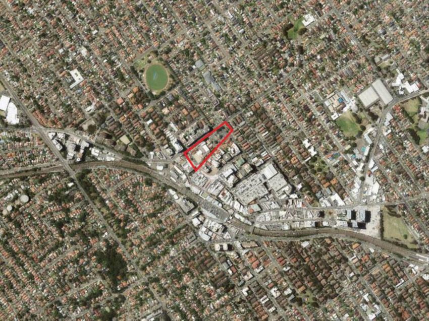
Table of Contents
Introduction .......................................................................................................... 7
1. [Part 1] Objectives and Intended Outcomes ................................................. 9
2. [Part 2] Explanation of Provisions ............................................................... 13
     2.1    The Planning Proposal ................................................................................. 13
            2.1.1       Proposed amendments to HLEP 2012 ............................................ 13
            2.1.2       Intended outcomes to be enabled by the PP .................................... 9
3. [Part 3] Justification ..................................................................................... 15
     3.1    Section A – Need for the Planning Proposal ................................................ 15
            3.1.1       Is the planning proposal a result of any strategic study or report? .. 15
            3.1.2 Is the planning proposal the best means of achieving the objectives or
            intended outcomes, or is there a better way? .............................................. 23
     3.2    Section B – Relationship to Strategic Planning Framework ......................... 24
            3.2.1 Is the planning proposal consistent with the objectives and actions
            contained within the applicable regional or sub-regional strategy (including
            exhibited draft strategies)? ........................................................................... 24
            3.2.2 Is the planning proposal consistent with the local council’s Community
            Strategic Plan, or other local strategic plan? ................................................ 32
            3.2.3 Is the planning proposal consistent with applicable State Environmental
            Planning Policies? ........................................................................................ 39
            3.2.4 Is the planning proposal consistent with applicable Ministerial Directions
            (s.9.1 directions)? ......................................................................................... 43
     3.3    Section C – Environmental, Social and Economic Impact ........................... 57
            3.3.1 Is there any likelihood that critical habitat or threatened species,
            populations or ecological communities, or their habitats, will be adversely affected
            as a result of the proposal? .......................................................................... 57
            3.3.2 Are there any other likely environmental effects as a result of the planning
            proposal and how are they proposed to be managed? ................................ 57
            3.3.3 How has the planning proposal adequately addressed any social and
            economic effects?......................................................................................... 60
     3.4    Section D – State and Commonwealth Interests ......................................... 62
            3.4.1       Is there adequate public infrastructure for the planning proposal? . 62
            3.4.2 What are the views of State and Commonwealth public authorities
            consulted in accordance with the gateway determination? .......................... 63
4. [Part 4] Mapping ........................................................................................... 64
     4.1    The Site ........................................................................................................ 64
            4.1.1       Site Description................................................................................ 64
            4.1.2       Legal Description ............................................................................. 64

CITY PLAN STRATEGY & DEVELOPMENT P/L - PLANNING PROPOSAL: HURSTVILLE CIVIC PRECINCT - JULY 2018                                    3/100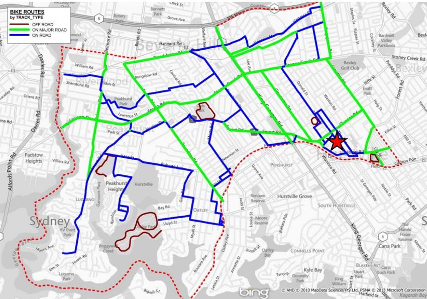
4.1.3       Site Features and Existing Development ........................................ 66
               4.1.4       Historical use of the site .................................................................. 70
               4.1.5       Surrounding Land Use Context ....................................................... 71
               4.1.6       Transport and Accessibility .............................................................. 76
      4.2      Current Planning Provisions ......................................................................... 77
               4.2.1       Current Land Classification ............................................................. 77
               4.2.2       Hurstville Local Environmental Plan 1994 ....................................... 77
               4.2.3       Hurstville Local Environmental Plan 2012 ....................................... 80
      4.3      Proposed Planning Provisions...................................................................... 82
               4.3.1       Proposed Land Classification .......................................................... 82
               4.3.2       Proposed Land Use Zoning ............................................................. 82
               4.3.3       Proposed Height of Buildings .......................................................... 83
               4.3.4       Proposed Floor Space Ratio ........................................................... 84
               4.3.5       Heritage ........................................................................................... 85
5. [Part 5] Community Consultation ................................................................ 86
6. [Part 6] Project Timeline ............................................................................... 87
7. Conclusion .................................................................................................... 88

Figures
Figure 1 Subject site .............................................................................................................. 7
Figure 2 Indicative impression of proposed Civic Plaza (DWP) .......................................... 10
Figure 3 Indicative impression of proposed Patrick Street Pocket Park (DWP) .................. 11
Figure 4 Proposed heights adjoining the Civic Precinct (source SJB/ GRC ....................... 17
Figure 5 Civic Precinct Case Study (source SJB/ GRC) ..................................................... 18
Figure 6 Recommended heights (Source: Dickson Rothschild) .......................................... 19
Figure 7 Civic Precinct Master Plan 2004 ............................................................................ 20
Figure 8 Civic Centre Diagram - Strategic Intent ................................................................. 22
Figure 9 Metropolis of 3 Cities Vision to 2056 (Source: Greater Sydney Region Plan 2018)
............................................................................................................................................. 25
Figure 10 South District Plan (source GSC) ........................................................................ 27
Figure 11 Housing targets by LGA in the South District (source GSC) ............................... 29
Figure 12 Green Grid connections in the South District (source GSC) ............................... 32
Figure 13 Sydney Airport OLS Map (Source SAMP 2033) .................................................. 50
Figure 14 Sydney Airport PANS-OPS Map (Source SAMP 2033) ...................................... 51
Figure 15 Bankstown Airport OLS Map (Source BAMP 2014) ............................................ 52
Figure 16 Bankstown Airport OLS Map with height limitations (Source Sydney Metro Airports/
Rehbein 2013) ..................................................................................................................... 53

CITY PLAN STRATEGY & DEVELOPMENT P/L - PLANNING PROPOSAL: HURSTVILLE CIVIC PRECINCT - JULY 2018                                          4/100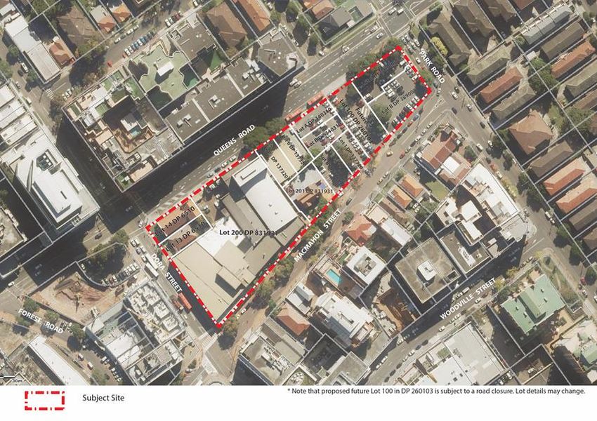
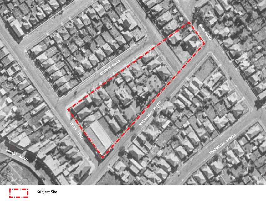
Figure 17 Bankstown Airport PANS-OPS Map (Source BAMP 2014) ................................ 54
Figure 18 Site location (source DWP) ................................................................................. 64
Figure 19 Cadastral setting of the site (source SIX Maps) Note: Lot 100 in DP 260103
(Patrick Street) is subject to road closure process and is subject to change ...................... 66
Figure 20 Georges River Council’s civic offices located at the corner of MacMahon Street
and Dora Streets .................................................................................................................. 67
Figure 21 The Marana Auditorium provides an entertainment destination on the site ........ 68
Figure 22 Hurstville Senior Citizens and community centre ................................................ 68
Figure 23 Hurstville Museum and Gallery is heritage listed ................................................ 69
Figure 24 Existing at-grade car park for Council worker and public at the Park Road end of
the site.................................................................................................................................. 69
Figure 25 Former Baptist Church on Dora Street and neighbouring dwelling house are
contained within the site. These are not heritage listed and have DA approval for demolition
............................................................................................................................................. 70
Figure 26 1943 Aerial imagery (source SIX Maps) .............................................................. 71
Figure 27 Surrounding land use context (source DWP) ...................................................... 72
Figure 28 High density development on the southern side of MacMahon Street incorporating
heritage items....................................................................................................................... 72
Figure 29 Church building at the corner of MacMahon Street and Park Road .................... 73
Figure 30 Bungalows on MacMahon Street opposite the site ............................................. 73
Figure 31 Six (6) storey mixed use development at the corner of MacMahon Street and Dora
Street .................................................................................................................................... 74
Figure 32 Existing Hurstville Library on the corner of Queens Road and Dora Street with
residential apartments above ............................................................................................... 74
Figure 33 Waratah Private Hospital on the corner of Queens Road and Dora Street opposite
the site.................................................................................................................................. 75
Figure 34 Three (3) storey walk up flat buildings along Park Road opposite the site. ........ 75
Figure 35 Traffic queues at the Queens Road Park Road intersection. .............................. 76
Figure 36 Surrounding Cycling Routes (source GTA) Subject site denoted by red star ..... 77
Figure 37 HLEP 1994 Land use map (source GRC) ........................................................... 78
Figure 38 HLEP 2012 Land use zoning (Source NSW Legislation) .................................... 80
Figure 39 HLEP 2012 Height of Building (Source NSW Legislation) .................................. 81
Figure 40 HLEP 2012 Maximum FSR mapping (Source NSW Legislation) ........................ 81
Figure 41 HLEP 2012 Proposed land use zoning (Source NSW Legislation) ..................... 83
Figure 42 HLEP 2012 Proposed Maximum Height of Building mapping (Source NSW
Legislation) ........................................................................................................................... 84
Figure 43 HLEP 2012 Proposed Maximum Floor Space Ratio mapping (Source NSW
Legislation) ........................................................................................................................... 85

CITY PLAN STRATEGY & DEVELOPMENT P/L - PLANNING PROPOSAL: HURSTVILLE CIVIC PRECINCT - JULY 2018                                         5/100

Tables
Table 1 Subject site lot details ............................................................................................... 7
Table 2 Land Use Indicative Floor Space ............................................................................ 12
Table 3 Indicative Floor Space Yields ................................................................................. 20
Table 4 Priority 9 Actions ..................................................................................................... 30
Table 5 Consideration of Council's Six Pillars ..................................................................... 33
Table 6 Nearby heritage items ............................................................................................. 46
Table 7 Land parcels forming the subject site ..................................................................... 64
Table 8 Existing land uses ................................................................................................... 66

Appendices

  Appendix              Document                                               Prepared by

  Appendix A            Concept Design Report                                  DWP

  Appendix B            Draft Site Specific DCP                                City Plan/ SPA/ DWP

  Appendix C            Transport Impact Statement                             GTA

  Appendix D            Preliminary Site Survey                                Harrison Friedmann and Associates

                        Plan of part of Patrick Street - creating              Stephen James Davey
                        (Proposed) Lot 100

  Appendix E            Table of SEPPs                                         City Plan

  Appendix F            Table of Section 9.1 Directions                        City Plan

  Appendix G            Community          Consultation       Outcomes         JBA/ Ethos
                        (2016)

  Appendix H            Mapping Amendments                                     City Plan

CITY PLAN STRATEGY & DEVELOPMENT P/L - PLANNING PROPOSAL: HURSTVILLE CIVIC PRECINCT - JULY 2018                             6/100
Introduction
This Planning Proposal (PP) has been prepared by City Plan Strategy & Development
(CPSD) on behalf of the Georges River Council to seek an amendment to the Hurstville Local
Environmental Plan 2012 (HLEP 2012) as it applies the Georges River Council owned site
bound by Queens Road, Dora Street, MacMahon Street and Park Road (subject site). The
subject site is known as the Hurstville Civic Precinct. The subject site is comprised of 12 land
parcels and a road reserve owned freehold by Georges River Council. These land parcels
are represented in Figure 1 and listed in Table 1.

Figure 1 Subject site

Table 1 Subject site lot details

  Lot         DP                     Address

  13          6510                   4-6 Dora Street, Hurstville

  14          6510                   4-6 Dora Street, Hurstville

  200         831931                 16-32 MacMahon Street, Hurstville

  5           137320                 91 Queens Road, Hurstville

  6           137320                 91 Queens Road, Hurstville

  201         831931                 14 MacMahon Street, Hurstville

  B           321590                 14A MacMahon Street, Hurstville

  A           340310                 3 Patrick Street, Hurstville

  B           340310                 1 Patrick Street, Hurstville

  1           137320                 6 MacMahon Street, Hurstville

CITY PLAN STRATEGY & DEVELOPMENT P/L - PLANNING PROPOSAL: HURSTVILLE CIVIC PRECINCT - JULY 2018   7/100
Lot         DP                     Address

  A           389008                 2 Patrick Street, Hurstville

  B           389008                 2 Patrick Street, Hurstville

  100         260103                 Patrick Street Road Reserve (Subject to road closure process)

It is noted that the majority of the site is classified as ‘operational’ under the Local
Government Act 1993, with the exception of land at the corner of Dora Street and Queens
Road known as 4-6 Dora Street (Lots 13 and 14 in DP 6510), which is currently classified as
‘community’ land.
The subject site currently accommodates the following development:
    ▪ Hurstville City Council’s Administration Building;
    ▪ Civic and Entertainment Centre;
    ▪ Baptist Church (recently acquired by Council and approved for demolition);
    ▪ Hurstville Museum and Gallery (heritage listed);
    ▪ Hurstville Senior Citizens Centre; and
    ▪ a car park for the use of Council officers and the public.
This PP seeks to amend the Hurstville Local Environmental Plan 2012 (HLEP 2012) to enable
the future development of a civic, cultural, community and residential destination on the
subject site within the Hurstville City Centre.
The Hurstville City Centre continues to undergo significant urban renewal that has led to its
rejuvenation and transformation as a vibrant strategic metropolitan centre. The rapid
transformation of Hurstville City Centre as a high density residential and mixed use urban
hub is particularly visible in areas close to the Hurstville train station and the shopping strip
along Forest Road in the heart of the City Centre. As the residential and employment
population of Hurstville City Centre and its surrounds increases, so does the need for
community facilities, cultural destinations, entertainment facilities and open space
opportunities to ensure the local community and visitors to Hurstville City Centre have
sufficient access to a variety place making amenities.
This Planning Proposal (PP) will enable Council to establish a new civic and cultural heart
for the Hurstville City Centre which will include a range of public benefits including new public
plazas, library, gallery, auditorium and theatre space, council chambers and parking for 1,200
cars including over 500 public car parking spaces (subject to a future car parking study). This
key community and civic and community destination will be complemented by new mixed use
residential opportunities that will further enhance the vibrancy and vitality of the locality.
The intent is to provide for the existing Georges River community and provide a high-quality
community asset that will provide for the existing and emerging population of residents and
visitors to the Hurstville City Centre.

CITY PLAN STRATEGY & DEVELOPMENT P/L - PLANNING PROPOSAL: HURSTVILLE CIVIC PRECINCT - JULY 2018      8/100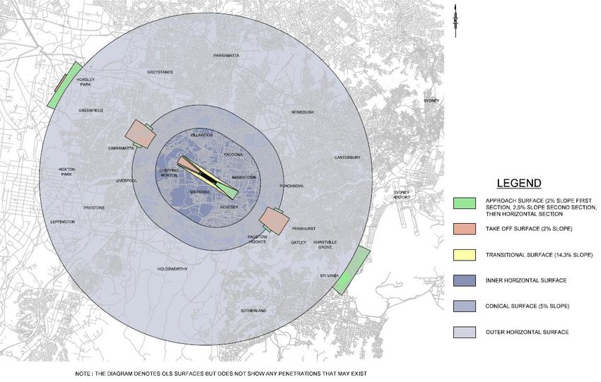
1.        [Part 1] Objectives and Intended Outcomes
This PP seeks an amendment to the Hurstville Local Environmental Plan 2012 to achieve
the necessary land classification, land use zoning, building height and floor space ratio to
enable the future redevelopment of the existing Hurstville Civic Precinct for a mixed use civic,
cultural, commercial and residential destination consisting of the following activities referred
to in the attached Concept Design Report prepared by DWP in Appendix A:
     ▪ Community space including library, museum and gallery display areas.
     ▪ Customer service centre, Council offices/chambers.
     ▪ Flexible auditorium/function space for a range of performance presentation activities
       (500 seats).
     ▪ Residential floor and commercial uses.
     ▪ Cafés and a range of recreation, relaxation or study areas.
     ▪ Basement car parking including underground parking for 1,200 vehicles including 500
       potential public car parking spaces.
The PP is supported by a Concept Design Report (Refer Appendix A) and draft site-specific
Development Control Plan (refer Appendix B) that seeks to guide detailed design and staging
matters to ensure the future development of the Hurstville Civic Precinct reflects design
excellence and embodies the intended place making qualities set out in the design concept.

1.1.1     Intended outcomes to be enabled by the PP
DWP’s Concept Design Report at Appendix A is the result of significant context analysis and
investigation of various design options for the site. The following summary outlines specific
outcomes that the PP seeks to enable through amendment of the subject site’s land use
zoning and maximum building height and floor space ratio controls.
The Planning Proposal provides the necessary building height, floor space ratio and land use
classification enable Georges River Council to deliver a new Civic Hub in the Hurstville City
Centre this will comprise the following key elements:
A vibrant civic, community and cultural destination
The PP will enable Georges River Council to provide new civic and cultural facilities on the
site, including:
     ▪ Georges River Council’s Administration Building and Council Chambers;
     ▪ Civic and Entertainment Centre, including multipurpose auditorium;
     ▪ Hurstville Library;
     ▪ Hurstville Museum; and
     ▪ Senior Citizens Centre.

CITY PLAN STRATEGY & DEVELOPMENT P/L - PLANNING PROPOSAL: HURSTVILLE CIVIC PRECINCT - JULY 2018   9/100
A New Civic Plaza

Figure 2 Indicative impression of proposed Civic Plaza (DWP)

A key feature of the proposal is a new and inclusive, active and enjoyable Civic Plaza space
that will form a new heart for the Hurstville City Centre, which is illustrated in Figure 2. The
plaza will be landscaped to include both hard and soft landscaping treatments which will
enable the space to perform variety of place making roles. This will allow for passive
recreation opportunities catering for a broad range of intergeneration needs. Its design will
enable both incidental use and programmed activities to occur. In particular, as a place for:
    ▪ community interaction and gathering for local residents, parents and children;
    ▪ rest and refreshment for visitors and shoppers;
    ▪ relaxation space for local workers to enjoy lunch and catch up with friends and
      colleagues;
    ▪ cultural events such as performances and busking;
    ▪ weekend farmers markets and food fairs showcasing local produce and foster
      grassroots business opportunities; and
    ▪ fun and play for kids where parents can enjoy the local food and café culture in close
      proximity to play space.
Hurstville’s new Civic Plaza will be positioned adjacent to MacMahon Street where it is best
connected to the wider Hurstville City Centre in a location that is protected from the high-
volume traffic routes of Park Road and Queen Street. The relationship between the Civic
Pla¬-za and existing heritage buildings on MacMahon Street will create a unique and ambient
atmosphere that showcases and celebrates Hurstville’s present and past.
Built form massing has been carefully considered to ensure that the majority of the Civic
Plaza receives a minimum of 2 hours sunlight in mid-winter, and particularly during the
lunchtime period when the usage of the plaza is expected to peak.
The place making qualities of the precinct will be further augmented by the rethinking of the
MacMahon Street design and its relationship to the plaza. While MacMahon Street is
intended to remain accessible to vehicle traffic, as a slow traffic its paving treatments will
encourage the slow moving of traffic with the feel of a pedestrian mall. This will facilitate the
occasional closing of the street to accommodate community events (e.g markets and
community fairs).

CITY PLAN STRATEGY & DEVELOPMENT P/L - PLANNING PROPOSAL: HURSTVILLE CIVIC PRECINCT - JULY 2018   10/100
Patrick Street Pocket Park Figure 3 Indicative impression of proposed Patrick Street Pocket Park (DWP) The Patrick Street pocket park will be situated between Buildings A and B and will align with Patrick Street. It provides a dual role as a public amenity for adjacent residents as well as maintaining the Patrick Street view corridor, which provides direct line access to Hurstville Oval. The Patrick Street Pocket Park is oriented towards the north, which, in conjunction with the careful design of adjacent buildings, allows for significant solar access to be archived throughout the year. Retail, office and eats street opportunities The PP will enable GRC to build upon on Hurstville City Centre’s role as an employment hub as well as its growing reputation as a key destination for shopping and eating out. It will enable new restaurants to interact with and activate the new Civic Plaza and thus provide for activity beyond regular 9-5 hours and enhance opportunities for ‘eyes on the street’ to increase the safety and enjoyment of the public realm. High quality office space is indented to be used by the Council administrative staff as well as enabling any commercial space surplus to Council’s needs to be taken up by private enterprise. Office space is intended to be located above the Council Chambers, which will ensure that the local government/ civic presence is retained in the westernmost portion of the site. New residential opportunities Hurstville is undergoing constant transformation as a residential lifestyle hub for apartment dwellers seeking to take advantage of the many city centre amenities as well as proximity to high frequency rail and road based public transport services. The PP will enable the development of two residential buildings with approximately 298 residential units. New apartments at the north eastern end of the site will assist in enhancing the vitality of local businesses. New apartments in this location will also assist in establishing an appropriate transition of land use towards the adjacent residential context. Vehicular access and car parking A new public car park will be provided in conjunction with the redevelopment of the site. This has potential to provide for some 500+ public car parking spaces on top of the required parking for individual land use components of the development. The exact number of public car parking spaces to be accommodated on the site will be subject to further detailed study and the outcomes of a car parking strategy currently being prepared by Council. This will enhance accessibility to both future activities in the new civic and cultural hub as well as enabling better access to other businesses and services within the Hurstville City Centre. CITY PLAN STRATEGY & DEVELOPMENT P/L - PLANNING PROPOSAL: HURSTVILLE CIVIC PRECINCT - JULY 2018 11/100
Site planning
The concept outlined in the DWP Concept Design Report at Appendix A and supporting draft
DCP at Appendix B are based on careful consideration for achieving design excellence,
staged delivery and establishing potential funding streams for the delivery of the community
cultural and civic facilities.
Site planning allows for the north eastern residential component of the site be developed or
disposed of separately. This would enable the generation of funds to be directed towards the
delivery of the community-oriented facilities on the southern portion of the site.
Proposed height of building and floor space ratio mapping provides sufficient articulation to
enable a variety of development staging opportunities to be realised.
Estimated floor space and apartment yields
Table outlines indicative floor space and apartment yield for the site that would be achievable
under this PP as reflected in the Concept Design Report at Appendix A:

Table 2 Land Use Indicative Floor Space

  Land Use                          Gross Floor Area (m2)                   Apartment Yield (units)

 Commercial                         7,500                                   -

 Council Chambers                   6,000                                   -

 Community                          8,410                                   -

 Retail                             3,160                                   -

 Residential                        25,975                                  298

  Total                             51,045                                  298

The intended outcome to be enabled by this PP is described in greater detail in the DWP
Concept Design Report provided as Appendix A.

CITY PLAN STRATEGY & DEVELOPMENT P/L - PLANNING PROPOSAL: HURSTVILLE CIVIC PRECINCT - JULY 2018       12/100
2.        [Part 2] Explanation of Provisions
2.1       The Planning Proposal
This PP has been prepared to address the guidelines set out in ‘A guide to preparing planning
proposals’ DPE 2016.
The PP has been prepared with the purpose of amending the HLEP 2012 to the extent to
which it identifies the subject site as a ‘Deferred Matter’ and is submitted to the Hurstville City
Council for assessment under Part 3 of the Environmental Planning and Assessment Act
1979 (EP&A Act).
Whilst the provisions of the Hurstville Local Environmental Plan 1994 (HLEP 1994) are
currently applicable to the subject site, this PP seeks amendment to the Hurstville Local
Environmental Plan (HLEP 2012), under which the subject site is identified as a ‘Deferred
Matter’ to establish an appropriate land use zoning, height and floor space ratio controls as
well as the necessary land classification to achieve the intended outcomes of this PP under
the current instrument.
This PP is underpinned by the following investigations and supporting documentation, which
form part of the strategic context and support the proposed amendments to the HLEP 2012:
     ▪ Hurstville Civic Precinct Concept Design Report - DWP (Appendix A).
     ▪ Draft Site Specific Development Control Plan (Appendix B).
     ▪ Traffic Impacts Assessment - GTA (Appendix C).
     ▪ Preliminary Site Survey/ Plan of part of Patrick Street - creating (Proposed) Lot 100
       (Appendix D).
     ▪ Table of Consistency with SEPPs (Appendix E).
     ▪ Table of Consistency with s9.1 Ministerial Directions (Appendix F).
     ▪ Community Consultation Outcomes Report (JBA 2016) (Appendix G).
     ▪ Proposed Mapping Amendments (Appendix H).

2.1.1     Proposed amendments to HLEP 2012
In particular, this PP seeks the following amendments to the HLEP 2012:

                                       Existing                           Proposed

  Land Use Zoning (LZN), Height of Buildings (HOB), Floor Space Ratio (FSR)

  LZN - Land use zone                  Deferred Matter                    B4 Mixed use

  HOB - Height of Buildings            No HOB Designation                 ‘X1’(48m), ‘P1’(17m) and ‘AA’(60m)

  FSR – Floor Space Ratio              No FSR Designation                 V’ (3.0:1) ‘AB’ (7.0:1) and ‘Z’ (5.0:1)

  Reclassification of Lot 13 in DP 6510 and Lot 14 in DP 6510 (known as 4-6 Dora Street)

  Land Classification                  Community                          Operational (all trusts discharged)

The majority of the site is site is classified as ‘operational’ under the Local Government Act
1993, which allows for its future development in accordance with the objectives and
permissible land uses within the B4 mixed use zone.
Lot 13 in DP 6510 and Lot 14 in DP 6510 (i.e. Baptist Church and adjoining land) were
acquired by Council on 31 March 2017. Land acquired under the Land Acquisition (Just
Terms Compensation) Act 1991 is transferred to Council with a default ‘community’
classification, including associated trusts. As such, these lots are currently classified as

CITY PLAN STRATEGY & DEVELOPMENT P/L - PLANNING PROPOSAL: HURSTVILLE CIVIC PRECINCT - JULY 2018             13/100
‘community’ land. This Planning Proposal seeks to reclassify these land parcels from ‘community’ to ‘operational’ land, and to discharge all trusts as necessary. This PP does not seek to amend the listing of heritage item (item I157) in Schedule 2 of the Hurstville 1994 LEP, noting that additional amendments to HLEP 2012 may be required by Council to include this item under the heritage provisions of HLEP 2012 as this heritage item is presently listed under the Hurstville Local Environmental Plan 1994. CITY PLAN STRATEGY & DEVELOPMENT P/L - PLANNING PROPOSAL: HURSTVILLE CIVIC PRECINCT - JULY 2018 14/100
3.        [Part 3] Justification
3.1       Section A – Need for the Planning Proposal

3.1.1     Is the planning proposal a result of any strategic study or report?
a) Does the proposal have strategic merit? Is it:
     ▪ Consistent with the relevant regional plan outside of the Greater Sydney Region,
       the relevant district plan within the Greater Sydney Region, or corridor/precinct
       plans applying to the site, including any draft regional, district or
       corridor/precinct plans released for public comment; or
     ▪ Consistent with a relevant local council strategy that has been endorsed by the
       Department; or
     ▪ Responding to a change in circumstances, such as the investment in new
       infrastructure or changing demographic trends that have not been recognised
       by existing planning controls.
This PP is underpinned by the Concept Design Report prepared for the Hurstville Civic
Precinct by DWP provided in Appendix A.
The need for a review of built form design controls in the Hurstville City Centre, including
height and FSR have been under consideration by the Hurstville City Council for some time
with numerous urban design studies being developed by Council to identify an appropriate
scale for the Centre.
The following documents culminate these considerations and represent the adopted position
of the Hurstville City Council with respect to the scale, density and character of future
development within the city centre and some that apply specifically to the subject site:
     ▪ Hurstville Civic Centre Master Plan (DWP 2018) (Refer Appendix A).
     ▪ Draft Hurstville City Centre Plan (SJB 2017).
     ▪ Hurstvillle City Centre Concept Master Plan (Government Architects Office 2004).
     ▪ Hurstville City Centre Urban Form Study (Dickson Rothschild 2007).
     ▪ Hurstville Public Domain Plan (Hurstville City Council 2007).
     ▪ Open Space, Recreation, Community and Library Facilities Strategy (Hurstville City
       Council 2010).
The precinct surrounding the subject site has been the focus of significant redevelopment
resulting in a major contextual transformation of the locality in recent years with development
on nearby sites in the order of 14 storeys. Further discussion demonstrating the consistency
of the PP with relevant strategic plans are provided in the following sections.

b) Does the proposal have site-specific merit, having regard to the following:
     ▪ the natural environment (including known significant environmental values,
       resources or hazards); and
     ▪ the existing uses, approved uses, and likely future uses of land in the vicinity of
       the proposal; and
     ▪ the services and infrastructure that are or will be available to meet the demands
       arising from the proposal and any proposed financial arrangements for
       infrastructure provision.
The PP is for an inner urban precinct and therefore environment significant of the site is
minimal.

CITY PLAN STRATEGY & DEVELOPMENT P/L - PLANNING PROPOSAL: HURSTVILLE CIVIC PRECINCT - JULY 2018   15/100
In the preparation of the Draft Hurstville City Centre Plan (SJB 2017), Georges River Council
undertook a review of development controls throughout the Hurstville City Centre to establish
an urban design vision that will underpin the scale of development in the Hurstville City
Centre into the future. This City Centre Plan represents an evolution and culmination of
previous city centre planning and underpins ongoing Council’s strategic intent for the
Hurstville City Centre. This plan envisages significant increase in scale and density across
the Hurstville City Centre in order to facilitate its growth as a key metropolitan strategic centre.
The PP will enable Council to utilise proceeds from residential development of the site to fund
key civic, community and recreational (i.e. open space) infrastructure to be accommodated
on the site as outlined in the Concept Design Report at Appendix A.
With respect to the various city centre planning initiatives preceding and current at the time
of preparing this PP as well as the DWP Concept Design Report provided at Appendix A, the
following common elements have been taken into consideration in the preparation of this PP:
▪ Role of the Hurstville Civic Precinct: previous strategic visions for the subject site
include a combination of land uses including civic, entertainment, commercial,
residential and public open space.
▪ Distribution of Building Bulk: The location of taller elements of built form of up to 18
storeys has generally been focused towards north eastern end of the site adjacent to
Park Street. The intent is to frame with civic plaza with taller buildings whilst enabling
solar access to the Civic plaza with reduced height in the centre of the site.
▪ Location of Civic Plaza: The proposed Civic Plaza is consistently proposed towards
the centre and south western end of the site with easy access to Dora Street, where
the relationship between the main activity areas of the Hurstville City Centre (e.g.
Forest Road, Westfield Shopping Centre) is strongest. This location also takes
advantage of a low traffic location and heritage and character built form elements of
MacMahon Street to frame the plaza in the most ambient part of the site with good
solar access in mid-winter.
Strategic merit of the proposal is further demonstrated in the response to the following
strategic documents below.
Hurstville Civic Centre Master Plan (GRC/ DWP 2018)
Georges River Council and DWP have prepared a Concept Design Report for the Civic
Centre Precinct, which is provided as Appendix A. The Concept Design Report aims to
revitalise and transform the Civic Centre Precinct into a vibrant, culturally significant and
inviting destination where people can live, work and interact. The vision of the Concept
Design Report is to:
▪ Showcase Hurstville as a vibrant place to work, shop and live;
▪ Set a new future direction for the Hurstville Civic Precinct;
▪ Reinforce Hurstville’s status as a Strategic Centre for Sydney; and
▪ Create a series of civic open spaces, community facilities, parks, commercial and
residential infrastructure.
The Concept Design Report aims to rationalise the civic facilities while improving the civic
focus through the creation of community facilities and public open space. It proposes a range
of different land uses including community facilities and outdoor space, Council Chambers
and Council offices, commercial, retail, residential and car parking.
The Concept Design Report has been prepared in conjunction with significant concept
options analysis as provided for in Appendix A.
Draft Hurstville City Centre Urban Design Strategy (GRC/SJB 2017)
The Draft Hurstville City Centre Urban Design Strategy (DHCCUDS) was prepared by SJB
on behalf of Georges River Council. The key objectives for the Urban Design Strategy are
to:
CITY PLAN STRATEGY & DEVELOPMENT P/L - PLANNING PROPOSAL: HURSTVILLE CIVIC PRECINCT - JULY 2018 16/100▪ reinforce the role Hurstville as the gateway to southern Sydney;
▪ strengthen the use of public and active transport to and within the centre:
▪ enhance and strengthen the identity of the Centre;
▪ promote pedestrian connectivity and movement; and
▪ provide block by block planning controls for the Centre.
The DHCCUDS does not make specific height and floor space ratio recommendations for
the Civic Precinct as the site is a ‘deferred matter’ under the HLEP 2012 and subject to this
separate site-specific planning proposal process. It is noted that the UDS does recommend
considerable uplift for sites throughout the Hurstville City Centre.
Building heights proposed by this PP have been considered in terms of establishing an
appropriate future relationship and transition between the subject site and neighbouring
lands. As the future development of the site will include a significant area of public open
space, the design approach is to focus taller buildings to the north and southern extents of
the site.
Figure 4 highlights the intended context in which the building heights proposed by the PP will
be located.
Figure 4 Proposed heights adjoining the Civic Precinct (source SJB/ GRC
The DHCCUDS includes a case study of the Civic Precinct Plaza, which notes the opportunity
to create a new civic urban space within the Civic Precinct and the high-level landscaping
elements and place making features and function of the space. The study recognises the
opportunity for a combination and hard and soft landscaping surfaces to facilitate passive
recreation performances, public gatherings, and public art installations. The Study notes the
opportunity for Council to consider the temporary closure of MacMahon Street to support
special events, which has been incorporated into the Concept Design Report at Appendix A.
The Study supports the location of this civic space to address MacMahon Street where it is
sheltered from the noise and traffic on Queens Road. Providing for adequate solar access
and opportunity is also a key consideration outlined in this Study.
Figure 5 notes a number of design elements outlined in the Study to be considered as detail
of the plaza is progressed. These have been addressed both with the Concept Design
Report at Appendix A and the draft site specific DCP provided as Appendix B.
CITY PLAN STRATEGY & DEVELOPMENT P/L - PLANNING PROPOSAL: HURSTVILLE CIVIC PRECINCT - JULY 2018 17/100Figure 5 Civic Precinct Case Study (source SJB/ GRC) The PP, DWP Concept Design Report at Appendix A and draft DCP at Appendix B are consistent with the above considerations. Hurstville City Centre Urban Form Study (Dickson Rothschild 2007) The Hurstville City Centre Urban Form Study, prepared on behalf of Council by Dickson Rothschild, is an examination of the potential built form and recommended development yield across the Hurstville City Centre. The Urban Form Study sought to complement the Hurstville City Centre Concept Master Plan (2004) and provide certainty for urban form controls. It aimed to optimise development potential within the Hurstville City Centre, whilst ensuring that development is consistent with best practice urban design. The Urban Form Study identifies the site as being located within the Civic Centre Precinct. The study reaffirms the potential for the site to accommodate an element of public par parking to be integrated within a future redevelopment. It also acknowledges that FSR and building height incentives will be required to achieve this outcome. The Urban Form Study identifies the site as appropriate for 16 storeys (53 metres) and ‘potential tower location’ at the north eastern end of the site as illustrated in Figure 6. CITY PLAN STRATEGY & DEVELOPMENT P/L - PLANNING PROPOSAL: HURSTVILLE CIVIC PRECINCT - JULY 2018 18/100
Figure 6 Recommended heights (Source: Dickson Rothschild)

The study was adopted in 2007. Since then, significant changes have occurred in the
planning system. The introduction of a new metropolitan strategy, The Greater Sydney
Region Plan became effective in 2018 and supports further intensification in established
railway-based centres, particularly strategic City Centres such as Hurstville.
The PP and Concept Design Report at Appendix A build upon the outcomes envisaged by
the Dickson Rothschild Urban Form Study. Reflecting the recommendations outlined in the
Urban Form Study, the PP will establish an appropriate building envelope through height and
FSR controls for the subject site that can be readily implemented in conjunction with the
requirements of SEPP 65 and the Apartment Design Guide (ADG), which is evident in the
Concept Design Report.
Hurstville City Centre Concept Master Plan (Government Architects Office 2004)
The Hurstville City Centre Concept Master Plan 2004 was adopted by Hurstville City Council
in 2004. It sets a number of key directions for the future of the centre of Hurstville with a focus
on setting out implementable outcomes rather than setting out broad development principles.
The Master Plan acknowledges Hurstville’s role as southern Sydney’s regional centre due to
its geographic, social and economic role along with Hurstville increasing importance through
population growth and economic development. The key objectives include:
    ▪ Consolidating Hurstville’s regional role.
    ▪ Creating a civic identity.
    ▪ Accommodating and strengthening the civic focus of the city centre.
    ▪ Providing efficient, well designed and accessible public transport.
    ▪ Improving pedestrian movement.
    ▪ Providing a framework by which improvements to infrastructure may be facilitated.
    ▪ Reinforcing retail activity along Forest Road.
    ▪ • Introducing a balanced approach to height and density.

CITY PLAN STRATEGY & DEVELOPMENT P/L - PLANNING PROPOSAL: HURSTVILLE CIVIC PRECINCT - JULY 2018   19/100
The Master Plan specifically identifies the subject site as an opportunity site for a revitalised mixed use civic precinct including a ‘sequence of open spaces’ and new/ increased public parking opportunities. The Master Plan identifies a new public open space in the form of a civic plaza at the southern end of the site at the corner of Dora and MacMahon Streets. It also envisages a strong link between MacMahon Street and Queens Road. Refer Figure 7. Figure 7 Civic Precinct Master Plan 2004 The Master Plan includes a vision for the Civic precinct as a consolidated precinct with community, entertainment and new Council offices with buildings of up to 12 storeys at the north eastern (Park Street) end of the site, with the Civic Plaza location towards the south west/ Dora Street end of the site. It is noted that the new arcade proposed by the Master Plan on the site on the south western side of Dora Street did not occur as a result of a more recent development of that site and as such that desire line has not been achieved as an approach to the site from Forest Road. The Master Plan envisaged the following floor space areas for identified land uses throughout the precinct. Table 3 Indicative Floor Space Yields Uses Floor space: Commercial space 27,000 m2 Council/ Civic space 4,300 m2 Entertainment space 3,000 m2 Community space 2,000 m2 The Master Plan also envisaged two (2) levels of below ground car parking including provision for public car parking spaces. A draft update to the Master Plan was undertaken by Hassell in May 2010, but was not adopted by Council. This PP and Concept Design Report prepared by DWP in Appendix A presents an evolution of the concept outlined in the Master Plan noting that significant population growth has CITY PLAN STRATEGY & DEVELOPMENT P/L - PLANNING PROPOSAL: HURSTVILLE CIVIC PRECINCT - JULY 2018 20/100
occurred since the preparation of this plan leading to a range of pressure points in the
metropolitan areas requiring the need for more opportunities for housing, open space,
amenity and enjoyment.
The PP will assist in delivering the outcomes envisaged by the Master Plan in that it proposes
a high density mixed use civic, community and commercial development of the site, which is
intended to facilitate increased provision of public car parking in the Hurstville City Centre.
As demonstrated in the DWP Concept Design Report at Appendix A, well located plaza
spaces and strong pedestrian interconnection is a key element of the intended outcomes
proposed by this PP, which is consistent with the overarching principles of the 2004 Master
Plan.
Open Space, Recreation, Community and Library Facilities Strategy (2010)
In 2010, the then Hurstville City Council commissioned the preparation of an Open Space,
Recreation, Community Facility and Library Strategy. It was intended as a strategic review of
the City’s broad open space, recreation, community facility and library current needs and
development of strategies for the future upgrade, and improvement of existing facilities and
provision of new facilities where necessary.
The Strategy was intended to provide Council with a framework for the planning and provision
of open space, recreation, community facilities and libraries to the year 2031 in order to be
able to respond to the increase in population expected in the (then) Hurstville Local
Government Area (LGA).
The Strategy recommended that:

       “the existing Civic Centre site on McMahon Street be utilised to provide an
       enhanced level of district level community and library facilities. These facilities will
       serve both the existing and future populations of Hurstville suburb (City Centre
       and Hurstville Suburb) and the wider district level needs of the Hurstville LGA.
       These could be incorporated into a large and high quality mixed use development
       that houses civic and community spaces, indoor and outdoor spaces,
       commercial/retail and residential development.”

The Strategy was undertaken to inform the preparation of the Hurstville Development
Contributions Plan to accommodate the needs of a growing population. Public facilities and
open spaces recommended for the Hurstville Civic Centre within the strategy are summarised
as follows:
    ▪ Larger library facility including informal community spaces, exhibition and gallery
      space.
    ▪ Multipurpose community centre including meeting rooms, flexible activity and youth-
      oriented spaces.
    ▪ Entertainment centre including a flexible auditorium/ function space.
    ▪ Office space for community organisations.
    ▪ Council offices and chambers.
    ▪ Town square/ civic plaza integrated with adjacent uses.
Figure 8 outlines the strategic intent for the Hurstville Civic Precinct and land uses to be
accommodated within the as envisaged within the Strategy.

CITY PLAN STRATEGY & DEVELOPMENT P/L - PLANNING PROPOSAL: HURSTVILLE CIVIC PRECINCT - JULY 2018   21/100
Figure 8 Civic Centre Diagram - Strategic Intent This PP will facilitate the delivery of the Strategy by providing the necessary floor space to achieve community facilities required to provide for a growing population in and around the Hurstville City Centre. It is also noted that since the preparation of this study, Council amalgamations have resulted in the merger of Hurstville and Kogarah LGAs placing greater pressure on the existing Council offices at the Hurstville Civic Centre. Hurstville s94 [s7.11] Development Contributions Plan 2012 (Amendment No. 2) The Hurstville Section 94 [s7.11] Development Contributions Plan 2012 (Amendment No.2) came into effect on 19 July 2017 and was been prepared to address anticipated demand for public amenities and public services generated by new development up to 2031. The s94 plan identifies the following as key reasons instigating the upgrade of the Civic Precinct: CITY PLAN STRATEGY & DEVELOPMENT P/L - PLANNING PROPOSAL: HURSTVILLE CIVIC PRECINCT - JULY 2018 22/100
▪ A substantial proportion of the Hurstville population increase, over 30 percent will live
      in the Hurstville City Centre.
    ▪ If current trends continue, that incoming population is likely to be primarily new
      migrants, primarily from Asian countries and will therefore require additional
      community support.
    ▪ Hurstville City Centre is identified as a Major Centre in the Metro Strategy and
      therefore should provide appropriate scale facilities for the broader, LGA-wide,
      catchment.
    ▪ Council has substantial land-holdings in the centre at the Civic Precinct, which would
      cater for an integrated community centre and administration building.
    ▪ As indicated in the guiding principles, a quality facility, at an appropriate size and scale,
      collocating services and facilities, as well as open space (plaza) and car-parking,
      creating a sense of place and helping build community cohesion would all point to the
      provision of a community hub at the Civic Precinct.
The s94 plan makes the following allocations for the Civic Precinct:
    ▪ $14,877,050 as a priority 1 project to upgrade links to the central library and museum
      complex/multi-purpose community centre.
    ▪ $28,186,947 towards the development of a new 6,477m 2 Central Library and Museum
      complex (district level facility).
    ▪ $10,164,714 towards the development of a 2,335m 2 multipurpose community centre
      including a senior citizens' centre and entertainment centre (district level facility).
This PP seeks to establish the necessary framework to enable Council to implement its
strategic vision for the Civic Precinct.

3.1.2     Is the planning proposal the best means of achieving the objectives or
          intended outcomes, or is there a better way?
In this circumstance, where there is a suitable large-scale site under single ownership, that
is located within an intensifying transit-oriented city centre within 200m of the Hurstville Train
Station and 100 metres from the Woodville Street Transport (Bus) Interchange, then a PP
that precedes a longer-term review of planning controls is considered warranted, particularly
where it is seeking to resolve a ‘Deferred Matter’.
A comparison between HLEP 1994 and the HLEP 2012, illustrates that land surrounding the
subject site was previously zoned 3(b) Business Centre zone (HELP 1994), which throughout
the City Centre has since been zoned under the HLEP 2012 as B4 Mixed Use. This is
considered a like-for-like transition between land uses from the 1994 instrument to the 2012
instrument.
Given the B4 Mixed Use and R3 Medium Density context of surrounding lands in proximity
to the subject site, a B4 Mixed use zone would be considered the most appropriate and
consistent with the surrounding context under the HLEP 2012 instrument. Key objectives and
permissible uses within the B4 zone permit development of the nature envisaged by this PP.
A PP is appropriate given Hurstville City Council had previously gazetted amendments to its
HLEP 2012 on 24 July 2015. This brought into line height and FSR controls into the
instrument, which had previously only been provided for in the HDCP 2. The subject site is
deferred under HLEP 2012 so the proposed PP will bring the site into line with surrounding
development and apply height and FSR controls.
Whilst the PP will result in a like-for-like transition from its current zoning under the HLEP, it
is appropriate to introduce height and FSR controls that are consistent with the intended
outcomes of the PP as well as providing an appropriate response to the surrounding and
emerging local context as reflected in this PP.
The PP seeks to rezone the site to an existing zone and include height and FSR standards
of HLEP 2012.

CITY PLAN STRATEGY & DEVELOPMENT P/L - PLANNING PROPOSAL: HURSTVILLE CIVIC PRECINCT - JULY 2018   23/100
The Concept Design Report at Appendix A prepared by DWP is underpinned by significant
consideration for a number of concepts that explored alternative approaches to massing
distribution, site planning outcomes. Concept options analysis undertaken considered:
▪ Staging of the delivery to enable the future sale of residential lots at the north eastern
end of the site and therefore establish the necessary funding stream to deliver the
community-oriented facilities and public benefits; and
▪ Impacts of the proposed massing and site planning configurations in terms of their
solar impacts on the new civic plaza and nearby built form and land uses and transition
of building bulk.
Concept options analysis also considered the accessibility and sense of connectivity between
the proposed civic plaza, the Forest Road shopping strip, Westfield Shopping Centre and the
wider Hurstville CBD. This analysis considered various alternative potential locations for the
Civic Plaza. It considered its central/ south west location as well as potential to locate the
civic at the northern end of the site. However, it was considered that locating the park to the
northern end of the site would diminish the plaza’s civic role by locating it on the periphery of
the City Centre in a location that was overrun by vehicle traffic and lacking in ambience.
The potential for the Civic Plaza to be framed by adjacent built form, which is a defining
characteristic of a Civic Plaza is strengthened by its central location. The location of the plaza
as provided for in the DWP Concept Design Report at Appendix A enables the creation of a
park in a location where it has appropriate levels of solar access, relates to the various
heritage buildings on MacMahon Street and has a direct relationship along the Barnett Street/
Dora Street desire line to the retail heart of the centre and nearby road and rail based public
transport facilities.
It is recognised that the articulation of maximum building height and FSR controls are limited
in their ability to guide the specific outcome intended by this PP. Therefore, a draft site
specific DCP has been prepared to guide the detailed design, land use distribution, place
making qualities and interrelationships with the precinct. The DCP will assist Council is
assessing and guiding the intended outcomes, while allowing for an appropriate level of
flexibility to address particular matters at the detailed design stage.
It is therefore considered that amending the HLEP 2012 and introducing a site specific DCP
as proposed is the most appropriate, efficient and effective means of achieving the intended
outcomes. This PP is the only way to achieve the intended high density mixed use
development outcomes on the subject site.
3.2 Section B – Relationship to Strategic Planning Framework
3.2.1 Is the planning proposal consistent with the objectives and actions contained
within the applicable regional or sub-regional strategy (including exhibited
draft strategies)?
Greater Sydney Region Plan - A Metropolis of Three Cities 2018
The Greater Sydney Region Plan - A Metropolis of Three Cities has been prepared by the
GSC and was adopted in March 2018. It is 20-year plan to manage growth and change and
is built on a 40-year vision where the people of Greater Sydney live within 30 minutes of their
jobs, education and health facilities, services and great places. This vision is consistent with
the 10 Directions established in the Directions for a Greater Sydney that are a set of common
guiding principles that will assist in navigating Greater Sydney’s future as follows:
1. A city supported by infrastructure.
2. A collaborative city.
3. A city for people.
4. Housing the city.
5. A city of great places.
CITY PLAN STRATEGY & DEVELOPMENT P/L - PLANNING PROPOSAL: HURSTVILLE CIVIC PRECINCT - JULY 2018 24/100You can also read