NON-TECHNICAL SUMMARY - MORDEN WHARF - REGENERATION RETHOUGHT
←
→
Page content transcription
If your browser does not render page correctly, please read the page content below
MORDEN
         WHARF.

NON-TECHNICAL
  SUMMARY

    REGENERATION RETHOUGHT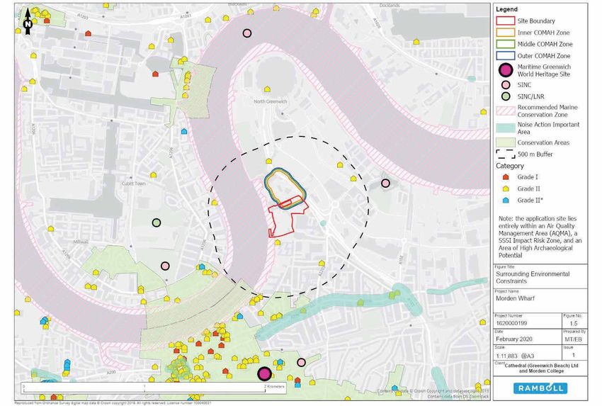
On behalf of                                         MORDEN WHARF
Cathedral (Greenwich Beach) Ltd and Morden College
                                                     NON-TECHNICAL SUMMARY
Date
May 2020

Project Number
1620000199

                                                     Project No.   1620000199
                                                     Issue No.     2
                                                     Date          14/05/2020
                                                     Made by       Rebecca Raby Smith
                                                     Checked by    Ben Weldin
                                                     Approved by   Michelle Wheeler

MORDEN WHARF
ENVIRONMENTAL
                                                      Made by:

                                                      Checked/Approved by:

STATEMENT
NON-TECHNICAL                                        This report is produced by Ramboll at the request of the client for the purposes detailed herein.

SUMMARY                                              This report and accompanying documents are intended solely for the use and benefit of the client
                                                     for this purpose only and may not be used by or disclosed to, in whole or in part, any other
                                                     person without the express written consent of Ramboll. Ramboll neither owes nor accepts any
                                                     duty to any third party and shall not be liable for any loss, damage or expense of whatsoever
                                                     nature which is caused by their reliance on the information contained in this report.

                                                     Version Control Log

                                                      Revision     Date         Made by    Checked by   Approved by   Description

                                                      1            11/05/2020   RRS        BW           MW            First Issue for Client Review

                                                      2            14/05/2020   RRS        BW           MW            Final Issue for Planning

                                                     Ramboll
                                                     240 Blackfriars Road
                                                     London
                                                     SE1 8NW
                                                     United Kingdom
                                                     T +44 20 7808 1420
                                                     www.ramboll.co.uk
NON-TECHNICAL SUMMARY                                                        NON-TECHNICAL SUMMARY
MORDEN WHARF                                                                 MORDEN WHARF

CONTENTS                                                                     8.8             Wind                                                                                           51
                                                                             8.9             Townscape, Heritage and Visual                                                                 52
                                                                             9.              CUMULATIVE EFFECTS                                                                             57
                                                                             9.1             Intra-Project Cumulative Effects                                                               57
1.           INTRODUCTION                                                1   9.2             Demolition and Construction                                                                    57
1.1          Purpose of Non-Technical Summary                            1   9.3             Completed Development                                                                          57
1.2          Viewing of ES and Application                               1   9.4             Inter-Project Effects                                                                          57
1.3          Commenting on Application                                   2   10.             SUMMARY                                                                                        59
2.           ENVIRONMENTAL IMPACT ASSESSMENT                             3
2.1          EIA Process and Methodology                                 3   LIST OF TABLES
2.2          EIA Scoping                                                 3
2.3          Topics Included in EIA                                      4   Table   6.1:   Proposed    Development       Area Schedule..................................................... 30
2.4          Topics Excluded from EIA                                    4   Table   6.2:   Proposed    Development       Unit and Tenure Mix by Percentage........................ 31
2.5          Assessment Approach                                         4   Table   6.3:   Proposed    Development       Building Heights .................................................. 31
3.           EXISTING SITE AND SURROUNDING CONTEXT                       6   Table   6.4:   Proposed    Development       Public Realm and Open Space Provisions ................ 34
3.1          Application Site Location                                   6   Table   6.5:   Proposed    Development       Play Space Provision ............................................ 34
3.2          Application Site Description                                7
3.3          Environmental Sensitivity                                  10   LIST OF FIGURES
4.           PLANNING CONSIDERATIONS                                    15
4.1          Policy Context                                             15   Figure   3.1:   Application Site Location ........................................................................ 6
4.2          Planning History                                           15   Figure   3.2:   Application Site Redline Boundary ........................................................... 8
5.           DESIGN EVOLUTION AND ALTERNATIVES                          16   Figure   3.3:   Application Site Photographs ................................................................. 10
5.1          ‘Do Nothing’ Alternative                                   16   Figure   3.4:   Surrounding Environmental Constraints ................................................. 14
5.2          Alternative Sites                                          16   Figure   5.1:   2018 Early Design Options.................................................................... 18
5.3          Alternative Land Uses                                      16   Figure   6.1:   Proposed Development Site Arrangement Plan ........................................ 21
5.4          Alternative Designs and Design Evolution                   17   Figure   6.2:   Gloriana Boathouse Site Plan ................................................................ 23
6.           PROPOSED DEVELOPMENT                                       20   Figure   6.3:   Proposed Basement Extent Parameter Plan ............................................. 26
6.1          Proposed Development Layout                                20   Figure   6.4:   Proposed Ground and First Floor Uses Parameter Plan .............................. 27
6.2          Proposed Development Land Use                              30   Figure   6.5:   Proposed Upper Level Floor Uses Parameter Plan..................................... 28
6.3          Proposed Development Built Form, Height and Massing        31   Figure   6.6:   Proposed Roof Parameter Plan .............................................................. 29
6.4          Proposed Development Material Palette and Façade Detailing 32   Figure   6.7:   Proposed Southern Warehouse Façade Alterations ................................... 33
6.5          Proposed Development Public Realm and Open Space Network   34   Figure   6.8:   Proposed Ground Level Landscape and Open Space Parameter Plan ........... 36
6.6          Proposed Development Biodiversity Enhancements             38   Figure   6.9:   Detailed Component Landscape General Arrangement.............................. 37
6.7          Proposed Development Lighting Strategy                     38   Figure   8.1:   Proposed Development Wind Tunnel Model ............................................. 51
6.8          Proposed Development Access                                38   Figure   8.2:   Greenwich Park General Wolf Statue View .............................................. 55
6.9          Proposed Development Deliveries and Servicing              40   Figure   8.3:   Royal Navy College View ...................................................................... 55
6.10         Proposed Development Plant and Ventilation                 40   Figure   8.4:   Blackwall Entrance Pier View ................................................................. 56
6.11         Proposed Development Climate Change Resilience Measures    41   Figure   8.5:   Chrischurch Way, East Greenwich Conservation Area View ....................... 56
6.12         Proposed Development Health and Wellbeing Measures         41   Figure   9.1:   Location of Cumulative Schemes ........................................................... 58
6.13         Proposed Development Operational Management Controls       42
7.           DEMOLITION AND CONSTRUCTION WORKS                          43
7.1          Overview                                                   43
7.2          Construction Environmental Management Plan                 43
7.3          Community Liaison                                          43
7.4          Working Hours                                              43
7.5          Potential Construction Environmental Effects               43
8.           WHAT ARE THE LIKELY SIGNIFICANT ENVIRONMENTAL EFFECTS OF
             THE PROPOSED DEVELOPMENT                                   44
8.1          Socio-Economics                                            44
8.2          Archaeology                                                44
8.3          Marine Ecology                                             45
8.4          Transport and Accessibility                                46
8.5          Air Quality                                                47
8.6          Noise and Vibration                                        48
8.7          Daylight, Sunlight, Overshadowing and Solar Glare          49

R1620000199_2_Morden Wharf Non Technical Summary                             R1620000199_2_Morden Wharf Non Technical Summary
NON-TECHNICAL SUMMARY                                                                                                         1   NON-TECHNICAL SUMMARY                                                                               2

MORDEN WHARF                                                                                                                      MORDEN WHARF

1. INTRODUCTION                                                                                                                         x   Non-Technical Summary (this document).

                                                                                                                                         This NTS and the full ES, together with the application and other supporting documents are
1.1    Purpose of Non-Technical Summary                                                                                                 available for viewing on the RBG’s website: https://planning.royalgreenwich.gov.uk/online-
        This is the Non-Technical Summary (NTS) of the Environmental Statement (ES) which has been                                       applications/
        prepared by Ramboll UK Limited (Ramboll) and a team of technical specialists in accordance with                                  CD versions of the ES are available for purchase from Ramboll at:
        the statutory procedures set out in the Town and Country Planning (Environmental Impact
        Assessment) (England) Regulations 2017 (hereafter referred to as the ‘EIA Regulations’)1.                                             240 Blackfriars Road
                                                                                                                                              London, SE1 8NW
        The ES has principally been prepared to accompany a planning application for hybrid planning
        permission (hereafter referred to as the ‘application’) made to the Royal Borough of Greenwich                                        Tel: 0207 808 1499
        (RBG) by Cathedral (Greenwich Beach) Ltd and Morden College (hereafter referred to as 'the
                                                                                                                                  1.3   Commenting on Application
        Applicant') for the intended residential-led, mixed-use redevelopment (hereafter referred to as
        ‘the proposed development’) of the Morden Wharf site, North Greenwich (hereafter referred to as                                  Comments on the application should be forwarded to the RBG at:
        'the application site').                                                                                                              Royal Borough of Greenwich
        The ES will also accompany a concurrent marine licence application to be submitted to the Marine                                      Planning Department
        Management Organisation (MMO) for permission to undertake works below the mean high water                                             The Woolwich Centre
        spring tide mark and therefore the ES has also had regard of the Marine Works (Environmental
                                                                                                                                              35 Wellington Street
        Impact Assessment) Regulations 20172 where relevant.
                                                                                                                                              London, SE18 6HQ
        The proposed development would comprise the demolition of all existing buildings, with the
                                                                                                                                              Email: planningapps@royalgreenwich.gov.uk
        exception of the Southern Warehouse which is proposed to be refurbished; excavation for a
        basement; construction of up to 18 new buildings up to approximately 130 metres above
        ordnance datum (mAOD; an indicative storey height of 36); delivery of residential, industrial/
        employment, retail, community and leisure floorspace; delivery of open space, public realm,
        landscaping; construction of a new river wall; refurbishment of the existing jetty and installation
        of the Gloriana boathouse; and improvements to the Thames Path, including the construction of a
        bridge link.

        This NTS presents a summary of the main findings of the environmental impact assessment (EIA)
        that has been undertaken of the proposed development and that has been reported in the ES.
        The NTS provides:

        x   a description of the application site and surrounding context;
        x   an outline of the reasonable development alternatives considered by the Applicant and an
             indication of the main reasons for their choice, taking into account the potential
             environmental impacts;
        x   a description of the proposed development; and
        x   a summary of the likely significant environmental effects predicted and key mitigation
             measures (as relevant).

        The aim of the NTS is to summarise the main findings of the ES in a clear and concise manner to
        assist the public in understanding what the significant environmental effects of the proposed
        development are likely to be.

1.2    Viewing of ES and Application

        The full ES comprises:

        x   Volume 1: Environmental Statement Main Report;
        x   Volume 2: Townscape, Heritage and Visual Impact Assessment;
        x   Volume 3: Technical Appendices; and

1 Secretary of State, 2017. The Town and Country Planning (Environmental Impact Assessment) Regulations 2017, London, HMSO.
2 Secretary of State, 2017. The Marine Works (Environmental Impact Assessment) Regulations 2017. London, HMSO.

R1620000199_2_Morden Wharf Non Technical Summary                                                                                  R1620000199_2_Morden Wharf Non Technical Summary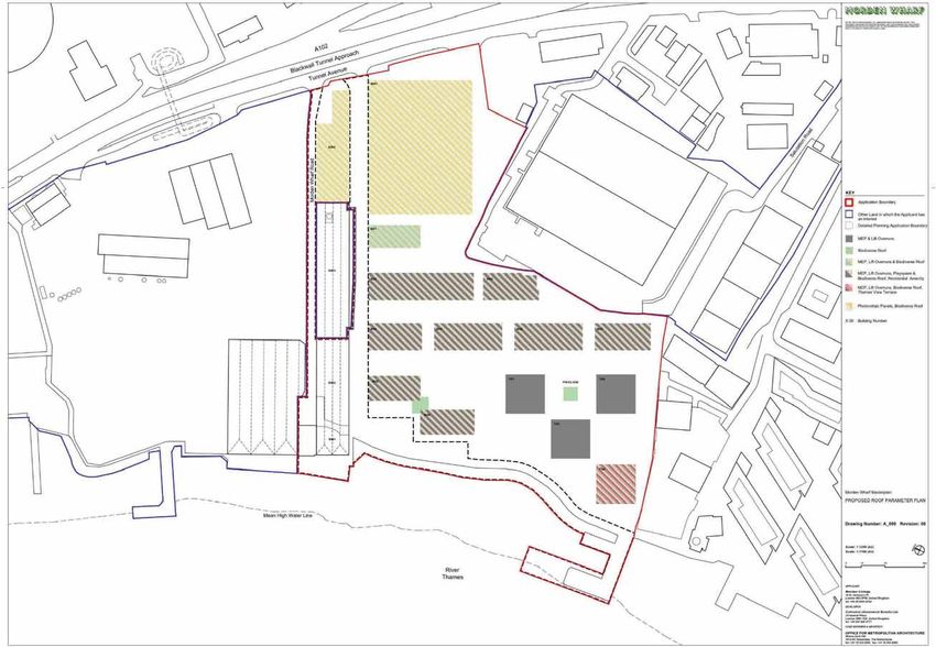
NON-TECHNICAL SUMMARY                                                                                                              3    NON-TECHNICAL SUMMARY                                                                                     4

MORDEN WHARF                                                                                                                            MORDEN WHARF

                                                                                                                                        2.3   Topics Included in EIA
2. ENVIRONMENTAL IMPACT ASSESSMENT
                                                                                                                                               The following topics were scoped into the EIA, as confirmed with the RBG during the EIA Scoping
2.1   EIA Process and Methodology                                                                                                             process, and their assessments are presented within ES chapters:
       EIA is a process that identifies the likely significant effects on the environment (both beneficial                                     x   Socio-Economics;
       and adverse) of a proposed development and proposes mitigation to avoid or reduce any likely
                                                                                                                                               x   Archaeology;
       significant adverse environmental effects. It is an iterative process which proactively seeks to
       integrate mitigation within the development proposals so as to avoid significant effects from                                           x   Marine Ecology;

       arising.                                                                                                                                x   Transport and Accessibility;

       The EIA process adopted for the proposed development has followed best practice guidelines, as                                          x   Air Quality;

       set out by the Institute of Environmental Management and Assessment (IEMA) Quality Mark                                                 x   Noise and Vibration;
       scheme. The process involved the following key steps:                                                                                   x   Daylight, Sunlight, Overshadowing and Solar Glare;

       x   Consultation was undertaken with key stakeholders such as the RBG, MMO, Greater London                                             x   Wind Microclimate; and
            Authority (GLA), EA, Transport for London (TfL) and Port of London Authority (PLA) on the                                          x   Townscape, Heritage and Visual.
            issues to be considered within the EIA;
                                                                                                                                               Significant environmental effects were considered unlikely to arise in respect of Ground
       x   Collection, use and assessment of the most up-to-date information on the baseline scenario
                                                                                                                                               Conditions, Water Resources and Flood Risk; Light Spillage, Telecommunication Interference,
            and likely evolution of that baseline without the development or in the future;
                                                                                                                                               Aviation, as well as Terrestrial Ecology and therefore scoped out of the EIA. However, these
       x   Interpretation of the development plans, schedule, parameters and commitments presented                                            topics were assessed to inform the design process. The conclusions of these assessments are
            in the design code, as well as the formulation of assumptions in the absence of information,                                       presented in technical reports which are included within the ES as the following technical
            as the basis for the individual technical assessments;                                                                             appendices:
       x   Use of relevant guidance and good practice methods to predict the potential nature, scale and
                                                                                                                                               x   Ground Conditions Preliminary Risk Assessment;
            significance of any environmental change; and
                                                                                                                                               x   Flood Risk Assessment and Drainage Strategy;
       x   Reporting of the results of the EIA process in the ES in a transparent way, to provide the
                                                                                                                                               x   Television and Radio Interference Report;
            information required to inform the decision-making process.
                                                                                                                                               x   Lighting Strategy and Light Impact Assessment Report;
2.2   EIA Scoping                                                                                                                             x   London City Airport Physical Safeguarding Assessment; and
       The EIA Scoping Report was formally submitted to the RBG on 9 October 2018 and accompanied           3
                                                                                                                                               x   Updated Preliminary Ecological Assessment.
       a request for formal EIA Scoping Opinion pursuant to Regulation 15(1) of the Town and Country
       Planning EIA Regulations. The EIA Scoping Report set out a description of the emerging proposed                                  2.4   Topics Excluded from EIA
       development; the potential key environmental impacts and likely effects to be considered as part                                        The following topics were scoped out of the EIA as confirmed during the EIA Scoping process:
       of the EIA; as well as the proposed approach that would be adopted for the EIA including the
                                                                                                                                               x   Climate Change;
       proposed scopes and assessment methodologies to predict the scale of effects and to assess the
       significance in each case.                                                                                                              x   Major Accidents and Disasters;
                                                                                                                                               x   Health and Wellbeing;
       A formal Scoping Opinion was issued by the RBG on 12 December 20184. The Applicant formally
       responded to the RBG to seek clarification on some of the EIA Scoping Opinion comments and a                                            x   Light Spillage;
       meeting was held with the RBG on 18 January 2019 to discuss the comments.                                                               x   Telecommunication Interference; and

       Given the passing of time, ongoing design evolution and subsequent amendments to the                                                    x   Aviation.
       proposed development application format, an informal re-scoping exercise was undertaken with
                                                                                                                                        2.5   Assessment Approach
       the RBG in January/February 2020 to confirm the validity of the scoping process and to identify
       updates to the EIA methodology, where required. The RBG confirmed in March 2020 that the                                                The ES provides assessments of potential significant environmental effects during demolition and
       amendments to the proposed development are not significant and that the proposed                                                        construction and once the proposed development is complete and operational. Each technical
       development remains materially consistent with that described in the 2018 EIA Scoping Report.                                           assessment considers different types of effects including direct effects and any indirect,
                                                                                                                                               secondary, cumulative, short, medium and long-term, permanent and temporary, beneficial and
                                                                                                                                               adverse effects. Where there is flexibility built in within the proposed development in terms of the
                                                                                                                                               land use areas (e.g. residential, commercial or community uses), the relevant topic areas within
                                                                                                                                               the EIA have assessed a scenario which reflects a worst-case scenario so as not to overinflate
                                                                                                                                               potential beneficial effects or underestimate potential adverse effects.
       3The EIA Scoping Report was submitted to the MMO on 5 November 2018 and accompanied a request for a formal EIA Scoping Opinion

       pursuant to Regulation 13 of the Marine Works EIA Regulations.
       4 MMO Scoping Opinion issued on 22 February 2019.

R1620000199_2_Morden Wharf Non Technical Summary                                                                                        R1620000199_2_Morden Wharf Non Technical Summary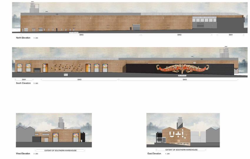
NON-TECHNICAL SUMMARY                                                                                        5   NON-TECHNICAL SUMMARY                                                                                    6

MORDEN WHARF                                                                                                     MORDEN WHARF

       Of particular note, the transport and accessibility, air quality and noise and vibration assessments      3. EXISTING SITE AND SURROUNDING CONTEXT
       have assessed a worst-case scenario for the proposed safeguarded wharf site (currently operated
       by Sivyer), where it is in use as a 24/7 concrete batching plant.                                         3.1   Application Site Location

       Each of the above issues are addressed in a separate technical assessment chapter in ES                          The application site is located in North Greenwich, immediately to the east of the River Thames
       Volumes 1 and 2. In each chapter, a description of the assessment methodology is given                           and immediately to the west of the A102, as shown in Figure 3.1.
       together with current application site conditions. This is followed by an assessment of the likely
       effects of the proposed development (beneficial, neutral and adverse) taking into account
       mitigation measures that are embedded in the development proposals; the consideration of the
       need for additional mitigation or any recommendations for enhancement measures to reduce or
       offset any significant adverse effects identified during the assessment; and a concluding
       assessment on the residual effects that would remain after these measures have been
       implemented, as well as the cumulative effects of the proposed development. The likely
       significant environmental effects attributed to the proposed development are then confirmed.

       Mitigation is the term used to refer to the process of avoiding where possible and, if not,
       minimising, controlling and/or off-setting potentially significant adverse impacts and effects of a
       development. As part of the iterative process, mitigation measures have been integrated
       (embedded) into the design stage; the demolition and construction stage; or the activities
       associated with the operation of the completed proposed development.

       ES Volumes 1 and 2 report upon the likely nature and scale of effect (whether it be Negligible,
       Minor/Slight, Moderate or Major), in order to determine what the likely significant effects of the
       proposed development would be. The results of this have been summarised in this document.

       In addition to the above, the following two types of cumulative effects have been assessed:

       x   Intra-Project effects of different types of impacts from the proposed development that could
            interact to jointly affect a particular receptor at the application site. Potential impact
            interactions could include the combined effects of noise and dust during demolition and
            construction activities on a particular sensitive receptor; and
       x   Inter-Project effects which are combined effects generated from the proposed development
            with other ‘approved or existing projects’ (‘cumulative schemes’). These ‘cumulative schemes’
            may generate their own individually insignificant effects but when considered together could
            amount to a significant cumulative effect, for example, combined landscape and visual
            impacts from two or more (proposed) developments.

       The list of cumulative schemes agreed during the RBG EIA Scoping process for the purpose of the
       inter-project cumulative impact assessment is discussed in Section 9.
                                                                                                                        Figure 3.1: Application Site Location

                                                                                                                        Geographically, the application site is located approximately:

                                                                                                                        x   1 km north of the north-east boundary of the Maritime Greenwich World Heritage Site (WHS);
                                                                                                                        x   0 m east of the River Thames and 680 m east of Mudchute Park and Farm;
                                                                                                                        x   700 m south of North Greenwich Underground Station and O2 Arena; and
                                                                                                                        x   400 m west of the Greenwich Peninsula Ecology Park.

                                                                                                                        The application site’s surrounding context is of a mixed nature with:

                                                                                                                        x   existing industrial and emerging residential-led mixed-use development to the north and east
                                                                                                                             as part of the Greenwich Peninsula Masterplan; and
                                                                                                                        x   existing industrial and existing and emerging residential uses to the north and south
                                                                                                                             respectively.

R1620000199_2_Morden Wharf Non Technical Summary                                                                 R1620000199_2_Morden Wharf Non Technical Summary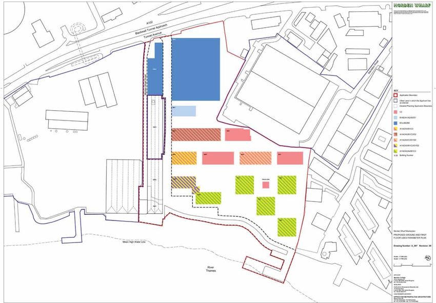
NON-TECHNICAL SUMMARY                                                                                                                7

MORDEN WHARF

3.2   Application Site Description

       The application site boundaries are defined to the:

       x     north by Go Ahead London Bus Garage, the Sivyer aggregates import and recycling facility at
              Tunnel Wharf (hereafter referred to as ‘Sivyer’) and the Brenntag UK chemical storage facility
              beyond;
       x     east by Tunnel Avenue and the A102 Blackwall Tunnel Southern Approach, with the
              Greenwich Peninsula Low Carbon District Energy Centre and associated sculpture, ‘The Optic
              Cloak’, beyond;
       x     south-east by City Cross Business Park (including Spicers Ltd, Glass Designs Ltd and Romax),
              with Tunnel Avenue and the A102 Blackwall Tunnel Southern Approach beyond;
       x     south by emerging mixed-use, residential-led Enderby Wharf development and The River
              Gardens Development beyond; and
       x     west by the River Thames, with the Isle of Dogs beyond.

       The Applicant is in control of Tunnel Wharf which is proposed as a Safeguarded Wharf (‘the
       proposed safeguarded wharf site’) under the Mayor of London Safeguarded Wharf Review 20195
       and has secured Siyver as the wharf operator.

       As shown in Figure 3.2, the application site is an irregularly shaped parcel of land which covers
       an area of approximately 5.6 hectares (ha). The part of the application site for which outline
       permission is being sought covers an area of 43,475 m2 (4.4 ha) and the detailed part covers an
       area of 12,992 m2 (1.2 ha).

       The application site lies at an elevation of between approximately 2.5 and 6 m AOD.

       5
           Greater London Authority, 2019. Safeguarded Wharves Review 2018 – draft Statement of Consultation. Summary of Round One
       Consultation August 2019.

R1620000199_2_Morden Wharf Non Technical Summary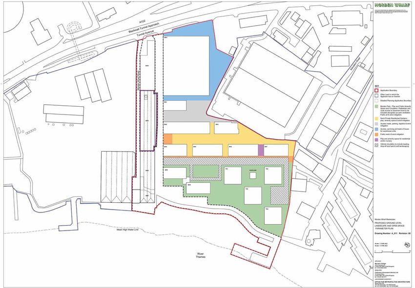
NON-TECHNICAL SUMMARY                           8
       MORDEN WHARF

       Figure 3.2: Application Site Redline Boundary

R1620000199_2_Morden Wharf Non Technical Summary
NON-TECHNICAL SUMMARY                                                                                         9   NON-TECHNICAL SUMMARY                                                                                       10
MORDEN WHARF                                                                                                      MORDEN WHARF

       The application site currently comprises:

       x   predominantly open yard space which is leased by several tenants on a short-term basis for
            storage use, including temporary closed storage and pre-fabricated office units in the centre
            and east of the application site, a storage shed (a one-storey, corrugated steel building) in
            the south, and shipping containers in the west. The yard space comprises hardstanding also
            in use as a surfaced car park in the centre of the application site and internal through roads;
       x   Thames Bank House, a three storey brick building, in the north-east of the application site.
            This building is mostly unoccupied, with the ground floor currently in office and light industrial
            use;
       x   Southern Warehouse, which is a one storey brick building (approximately 12 m high) in the
            north of the application site. The building comprises SW1, SW2 and SW3 and is currently in                   Aerial view of jetty, Thames Path and container            Southern Warehouse facing north-west
            manufacturing and storage use. Whilst SW1 and SW2 form part of the application, only the                     storage yard facing north-east

            façade of SW3 is included within the application boundary;
       x   a concrete jetty in the south-western extent of the application site, comprising two leg
            sections which extend from the main section;
       x   river wall along the western boundary which comprises two distinct lengths of wall running
            parallel to the river; the north and south walls. The north wall is located around the Southern
            Warehouse and is constructed from tied sheet piles with a reinforced concrete capping beam.
            The south wall exists in two different sections with the southern portion understood to be
            comprised of a small mass concrete wall varying in height and condition. The southern extent
            is a much larger wall which is understood to be comprised of bricks, concrete and rendering;
       x   the Olympian Way river path (the Thames Path) which is a single walkway ranging from 1.5
            m to 2 m in width comprising blockwork paving stones;                                                        Car parking facing north-east                              Storage yard and corrugated barn facing south

       x   the revetment which runs alongside the river path and slopes down from the path to the
            foreshore area of the River Thames comprising a rubble mass of masonry with cementitious
            screed topping;
       x   an area of the River Thames to the north of the jetty and along the river wall; and
       x   Morden Wharf Road along the northern edge of the application site, used for access to the
            rear of the Southern Warehouse, the Go Ahead London Bus Garage and proposed
            safeguarded wharf site, as well as providing a secondary entrance for Brenntag UK.

       There are no existing basements on the application site.

       In total, 12 individual trees and one group of trees are present on the application site along with
       several small areas of introduced shrub, none of which are protected by Tree Preservation Orders
       (TPOs).
                                                                                                                         Yard space with Enderby Wharf in background                Thames Path adjacent to jetty facing south
       Representative photographs of the application site are shown in Figure 3.3.                                       facing south
                                                                                                                         Figure 3.3: Application Site Photographs

                                                                                                                  3.3   Environmental Sensitivity

                                                                                                                  3.3.1 Ground Conditions
                                                                                                                         x   The geological sequence beneath the application site comprises ‘made ground’ (e.g. soil and
                                                                                                                              other materials used to build up site levels in the past), overlying geologically recent
                                                                                                                              superficial deposits of clay, peat and gravel), underlain by impermeable clay. The clay is in
                                                                                                                              turn underlain by clay and sands, with the undelaying bedrock being chalk. The shallow
                                                                                                                              superficial deposits and deeper sand and chalk are classified as aquifers.

R1620000199_2_Morden Wharf Non Technical Summary                                                                  R1620000199_2_Morden Wharf Non Technical Summary
NON-TECHNICAL SUMMARY                                                                                                                    11    NON-TECHNICAL SUMMARY                                                                                       12
MORDEN WHARF                                                                                                                                   MORDEN WHARF

3.3.2 Water Resources                                                                                                                                     Street found prehistoric land surfaces containing Neolithic and Bronze Age flint and pottery,
       x     The River Thames runs adjacent to the western boundary of the application site and is the                                                    the remains of a 12th century tide mill and evidence of the development of the foreshore from
              nearest surface water body. The application site is located entirely within Flood Zone 3 (High                                               the 17th - 20th centuries.
              Probability) associated with tidal flooding from the River Thames; however, the designation of                                          x   A preliminary assessment of the application site indicates that it is located within an area
              Flood Zone 3 specifically ignores the presence of any flood defences or structures in the                                                    formerly known as Greenwich Marsh, which in prehistoric times (approximately 800,000 BC –
              floodplain. The application site is afforded flood protection by the Thames Tidal Defences                                                   AD 43) formed a low-lying floodplain. On-site archaeological horizons exist within the
              (TTD) which are designed to offer at least a 1 in 1,000 Standard of Protection, i.e. the                                                     floodplain gravels and floodplain alluvium, which mainly date from the prehistoric period, and
              defences afford protection against events with a 0.1 % annual probability.                                                                   in some locations, from the medieval and early post-medieval periods.

3.3.3 Ecology                                                                                                                                        x   There are no statutorily designated heritage assets, such as scheduled monuments or
                                                                                                                                                           registered parks and gardens, within the application site. The following six Grade II listed
       x     No statutory designated nature conservation sites are located within the boundaries of the
                                                                                                                                                           buildings are located within approximately 500 m of the application site boundary:
              application site. Moreover, the application site is not located within 2 km of any national or
              European designated sites including any associated with the marine or water environment. A                                                      Enderby House;
              section of the Thames Estuary is recommended as a Marine Conservation Zone (rMCZ), the                                                          Millwall Wharf Riverside Range of Warehouse (Isle of Dogs);
              Swanscombe rMCZ, which is approximately 20 km downstream of the application site. The                                                           Southern Gatehouse to the Blackwall Runnel;
              Thames Estuary and Marshes Site of Special Scientific Interest (SSSI), Special Protection
                                                                                                                                                              70-84 River Way;
              Area (SPA) and Ramsar site are located approximately 30 km downstream of the application
                                                                                                                                                              Rothbury Hall; and
              site. Thames Estuary and Marshes site is an internationally important wetland habitat and
              supports important numbers of wintering wildfowl and wading birds and migrating birds.                                                          The Plot.

       x     Mudchute Park and Farm is also a local nature reserve (LNR). In addition, A small LNR, Bow                                              x   The Maritime Greenwich WHS is located 1 km to the south-west and includes the Grade II
              Creek Ecology Park, is located approximately 1.5 km to the north-east of the application site                                                Registered Greenwich Park.
              on a peninsula created by a meander in Bow Creek.                                                                                       x   The application site is not located within a conservation area. The following three
       x     Seven Sites of Importance for Nature Conversation (SINC) are located within approximately 1                                                  conservation areas are located within approximately 1 km of the application site boundary:
              km of the application site boundary, including the River Thames and Tidal Tributaries                                                           East Greenwich;
              immediately west, designated at the metropolitan level and Mudchute Park and Farm.                                                              Island Gardens (on the Isle of Dogs); and
       x     Terrestrial ecological surveys of the application site were undertaken in 2015, 2018 and                                                        Coldharbour (on the Isle of Dogs).
              2020. These surveys confirm that the terrestrial habitats comprising hardstanding; buildings
              and other structures; ephemeral short perennial vegetation; bare ground; introduced shrub;                                       3.3.5 Townscape and Views
              and scattered trees are of low ecological value. No evidence of black redstarts or roosting                                             x   The prevailing townscape character predominantly comprises a number of lower-rise
              bats were identified on the application site.                                                                                                warehouse structures and open areas to the north and east of the application site associated

       x     Aquatic surveys of the application site were undertaken in 2019, comprising the River                                                        with industrial uses and vacant sites for redevelopment; as well as early to mid-19th century

              Thames, a tidal estuary; an area of foreshore including Biodiversity Action Plan (BAP) Priority                                              houses to the south. The emerging Enderby Wharf development to the south has introduced

              Habitat of intertidal mudflats; the River Thames concrete river wall running along the western                                               several residential buildings up to approximately 50 m AOD in height. Upon completion of

              extent of the application site; and the jetty located to the southern end of the foreshore area                                              Enderby North (Enderby Place) it is expected to introduce residential towers up to 32 storeys

              in the southwest corner of the application site. The survey confirmed that the intertidal                                                    high, indicatively up to 100 m AOD in height. The emerging new townscape further north on

              habitat is largely barren, generally characterised by mud, sand and shingle beds with very                                                   the Greenwich Peninsula includes residential led mixed-use buildings up to approximately 36

              low diversity and few individuals present.                                                                                                   storeys high, indicatively 112.5 m AOD.

       x     The River Thames provides a migration route for many aquatic species including salmonids                                                x   The gasholder located approximately 150 m north-east of the application site, forms a

              and eels. The River Thames is also a valuable nursery for many commercially fished species                                                   prominent townscape feature in the local townscape. However, the gas holder has a Prior

              in the North Sea. Marine mammals have been recorded in the River Thames including                                                            Approval for demolition and has been partly demolished.
              dolphins, porpoises and seals some species of which are legally protected as European                                            3.3.6 Transport and Accessibility
              Protected Species (Habitats Directive, 92/43/EEC)6.
                                                                                                                                                      x   The application site is accessed off Tunnel Avenue which is located parallel to the A102
3.3.4 Below and Above Ground Heritage                                                                                                                     Blackwall Tunnel Approach. The Silvertown Tunnel, linking the Greenwich Peninsula to
       x     The application site is located within the Greenwich Peninsula and Foreshore Archaeological                                                  Silvertown, is anticipated to open in 2025 and is aimed at reducing congestion at the
              Priority Area (APA).                                                                                                                         Blackwall Tunnel.

       x     Archaeological investigations adjacent to the application site revealed mainly 19th - 20th                                              x   The application site is situated in a location with low public transport accessibility with a
              century remains. In addition, an archaeological investigation 350 m to the south at Banning                                                  public transport accessibility level (PTAL) rating of 1a/1b.
                                                                                                                                                      x   The North Greenwich London Underground (LU) Station (serviced by the Jubilee Line) is
       6                                                                                                                                                   located to the north within approximately 1.4 km walking distance of the application site.
           The Council of the European Communities, 1992. Council Directive 92/43/EEC of 21 May 1992 on the conservation of natural habitats
       and of wild fauna and flora. Available at: https://eur-lex.europa.eu/legal-content/EN/TXT/?uri=CELEX%3A31992L0043

R1620000199_2_Morden Wharf Non Technical Summary                                                                                               R1620000199_2_Morden Wharf Non Technical Summary
NON-TECHNICAL SUMMARY 13
MORDEN WHARF
x Maze Hill and Westcombe Park national rail stations (serviced by Thameslink and
Southeastern) are located to the south and south-east respectively at approximately 1.6 km
walking distance from the application site.
x The nearest bus stops are located on Tunnel Avenue/Dreadnought Street via a footbridge
over the A102, from which the 108 service between Lewisham and Stratford can be accessed.
There are also bus stops on Blackwall Lane, providing additional bus service options.
x Cycle routes are limited to the centre and east side of the peninsula. National Cycle Route
number 1 passes through the peninsula.
x Pedestrian facilities are limited to footways and the Thames Path, again with segregated
footpaths generally in the centre and east side of the peninsula. The A102 is a key source of
severance for local walk and cycle routes across the peninsula.
3.3.7 Noise and Air Quality
x Due to the application site's urban location, the main existing noise sources comprise road
traffic noise from the A102 and noise from surrounding industrial and river activity (e.g.
Thames Clippers, barges, etc.). Future noise sources are anticipated to be from the fully
operational proposed safeguarded wharf site. A Noise Action Important Area (areas identified
for local management of noise levels) is located approximately 600 m south of the application
site, encompassing the Woolwich Road (A102) flyover.
x The whole of the borough has been declared an Air Quality Management Area (AQMA) for
both exceedances in NO2 and PM10 levels. Existing air quality at the application site is affected
by road traffic emissions on the main road network to the east and by existing industrial uses
to the north and south-east, including Brenntag UK and City Cross Business Park respectively.
3.3.8 Major Accidents and Disasters
x Brenntag UK warehouse, a chemical distributor, is situated north of the application site and
undertakes activities which are regulated under the Control of Major Accident Hazards
(COMAH) Regulations 20157. Brenntag UK is designated as a ‘Lower Tier’ COMAH site, holding
lower quantities of dangerous substances than a ‘High Tier’ COMAH site. The north-eastern
corner of the application site lies within the Inner, Middle and Outer Zones of the Consultation
Distance (CD) of the Brenntag lower-tier COMAH site. Each zone within the CD is subject to
specific HSE development guidance, which sets out criteria to be met for different
development types to ensure the development is safe in the event of an accident or
emergency.
3.3.9 Aviation
x London City Airport lies approximately 2.7 km north-east of the application site, north of the
River Thames. The physical safeguarding zone extends to 10 km from the airport in a circle
centred on the midpoint of the runway. The most limiting restrictions apply along the runway
axis, but elsewhere a horizontal limit of approximately 155 m AOD applies out to the 10 km
radius from the airport. The application site lies in the transition area between the more
limiting runway-aligned restrictions and the 155 m AOD outer horizontal surface.
3.3.10Telecommunications
x A telecommunications mast operated by Arqiva is located within the application site on
Thames Bank House.
Figure 3.4 shows some of the key environmental constraints within and surrounding the
application site.
7 Health and Safety Excecutive, 2015. The Control of Major Accident Hazards Regulations 2015.
R1620000199_2_Morden Wharf Non Technical SummaryNON-TECHNICAL SUMMARY 14
MORDEN WHARF
Figure 3.4: Surrounding Environmental Constraints
R1620000199_2_Morden Wharf Non Technical SummaryNON-TECHNICAL SUMMARY 15 NON-TECHNICAL SUMMARY 16
MORDEN WHARF MORDEN WHARF
4. PLANNING CONSIDERATIONS 5. DESIGN EVOLUTION AND ALTERNATIVES
4.1 Policy Context The EIA Regulations require the ES to report on the reasonable alternatives (for example in terms
In respect of the application for hybrid planning permission, it is necessary to consider the of development design, location, size and scale) studied by the Applicant, which are relevant to
proposed development against relevant policies and guidance at national, regional and local the proposed project and its specific characteristics, and an indication of the main reasons for
levels. At the national level, planning policy is contained within the National Policy Planning selecting the chosen option, including a comparison of environmental effects.
Framework (NPPF)8,9. The ES considers the following alternatives:
The relevant statutory development plan for the application site comprises the: x The ‘Do Nothing’ alternative;
x London Plan (2016)10; and x Alternative sites;
x Royal Greenwich Local Plan11. x Alternative land uses;
Within the London Plan, the application site is located within the Greenwich Peninsula Opportunity x Alternative layouts and massing;
Area and partly located within the Thames Policy Area. x Alternative façades; and
In addition, the northern and eastern extent of the application site is designated as a Strategic x Alternative landscaping.
Industrial Location (SIL) (Preferred Industrial Location) and part of the application site is
5.1 ‘Do Nothing’ Alternative
designated as a Safeguarded Wharf. The Greater London Authority’s (GLA’s) Safeguarded Wharfs
Review (2018-2019) recommends that the safeguarded wharf designation is ‘flipped’ from the The ‘Do Nothing’ scenario is a hypothetical alternative conventionally considered, albeit briefly, in
‘Southern Site’, which includes an area of the application site, to the ‘Northern Site’, located to the EIA as a basis for comparing the development proposal under consideration.
the north of the application site (also known as the ‘proposed safeguarded wharf site’). The In the ‘Do Nothing’ alternative, the application site could be left in its current underutilised state
Mayor of London’s formal recommendations were submitted to the Secretary of State (SoS) in resulting in the following:
January 2020, which include the recommendation to flip the safeguarded wharf designation. A
decision from the SoS on the wharves review is awaited. x No delivery of increased employment opportunities in accordance with planning policy
objectives and the SIL designation;
Within the Royal Greenwich Local Plan, the London Plan SIL, Safeguarded Wharf and Thames
x No intensification of industrial floor space;
Policy Area designations are carried through from the London Plan. The application site is also
identified as falling within the Greenwich Peninsula West Strategic Development Location and is x No delivery of housing, including affordable homes, retail and community space contrary to
identified as a location where tall buildings ‘may be appropriate’. Part of the river frontage of the planning policy objectives;
application site is designated as part of the River Thames SINC and, in recognition for the need x No improvement in neighbourhood connectivity and permeability;
for the Thames Path to be improved, the existing path is identified as a ‘Riverside Walk: New x No improvement in public realm or creation of open space (including the delivery of a new
Improved’ route. The Tunnel Avenue frontage is also identified as falling within the River Crossing riverside park);
Safeguarding designation associated with Tunnel Avenue, identified for a new improved route.
x No improvement in biodiversity;
The Mayor of London issued his ‘Intending to Publish’ version of the Draft New London Plan 12 to x No improvement to Flood Defences;
the SoS in December 2019. The RBG has also consulted on the Site Allocations Local Plan since
x No improvement to the Thames Path, which is currently as narrow as 1.5 m and is identified
2016, within which the application site is proposed to form part of the ‘GP2 Former Tunnel
as being in need of improvement; and
Glucose Wharf (West)’, a strategic site allocation for mixed-use development on the Greenwich
x No improvement works to the jetty, which includes a lost opportunity to provide a new
peninsula.
permanent home for the Queen’s rowbarge, Gloriana.
A range of regional and local supplementary guidance documents are also relevant to the
Consequently, the Applicant ruled out the ‘Do Nothing’ alternative.
determination of the application and have been considered in undertaking the EIA.
4.2 Planning History 5.2 Alternative Sites
The application site has been in operation for light industrial use across the 21st century and has The Applicant owns the application site. No alternative sites were therefore considered.
been occupied by several tenants. The last application submitted in relation to the application site It is recognised that the application site is located within the designated Greenwich Peninsula
was for the installation of a temporary café and other associated works for a period of three Opportunity Area, as designated in the London Plan, which aims to create mixed-use areas and
years, which was permitted in October 2015. Further information on the planning history of the deliver a substantial amount of the new homes and jobs. The application site is therefore
application site is contained in the Planning Statement which accompanies the application. considered appropriate for the proposed development.
8 Secretary of State for Housing, Communities and Local Government, 2019. The National Planning Policy Framework. London. HMSO. 5.3 Alternative Land Uses
9 In respect of the application for marine licence permission, the 2011 UK Marine Policy Statement (prepared and adopted for the
The northern and eastern extent of the application site is designated as SIL and therefore the
purposes of section 44 of the Marine and Coastal Access Act 2009) and the South East Inshore Marine Plan are relevant.
10 Greater London Authority, 2016 (Updated 2017). The London Plan: The Spatial Development Strategy for London Consolidation with land uses within this section of the application site are limited to industrial uses and ancillary
Alterations since 2011. London. GLA uses. Furthermore, the north-eastern extent of the application site lies with within the Brenntag
11 RBG, 2014 (Updated 2016). Royal Greenwich Local Plan: Core Strategy with Detailed Policies. London. RBG.
12 Greater London Authority, 2019. The London Plan Intend to Publish: Spatial Development Strategy for Greater London. London. GLA. COMAH Zones, which limits potential development options.
R1620000199_2_Morden Wharf Non Technical Summary R1620000199_2_Morden Wharf Non Technical SummaryNON-TECHNICAL SUMMARY 17 NON-TECHNICAL SUMMARY 18
MORDEN WHARF MORDEN WHARF
Appropriate land uses for the redevelopment of the application site have also been informed by
the London Plan Opportunity Area policy, Greenwich West Masterplan Supplementary Planning
Document13, emerging Site Allocations Local Plan, as well as pre-application feedback from the
RBG and the GLA which have identified the potential for a mixed-use development comprising
industrial, residential, commercial and retail uses.
Accordingly, no alternative land uses were considered in the design evolution process.
5.4 Alternative Designs and Design Evolution
A long and iterative design evolution process has been undertaken since 2013 that has been
informed by the following key environmental factors:
x Townscape character, visual and heritage impacts to designated heritage resources and
views;
x Noise, air quality and microclimate (wind, daylight and sunlight) impacts;
x Flood risk;
x Application site designations (SIL and Safeguarded Wharf) and site suitability in relation to
industrial activities;
Figure 5.1: 2018 Early Design Options
x Socio-economics and the creation of employment opportunities;
x Public, communal and play space provisioning; Option 1, comprising the typological mixture, was selected as the preferred option based on the
following environmental comparison of the three options:
x Permeability and accessibility;
x Archaeology; x Townscape: compared to options 2 and 3, Option 1 mirrors the existing and emerging mixed
typologies surrounding the application site, with the higher-rise elements of the scheme
x Ground contamination;
positioned adjacent to the emerging high-rise Enderby Place development, with other new
x Marine ecology;
buildings stepping progressively down in height to the low-rise industrial buildings at the
x Major accidents and disasters; north and eastern edges of the application site. Furthermore, the provision of high-rise
x Telecommunications; and buildings associated with Option 1 would enable a large public realm offering to be delivered
x Aviation. via a large riverfront park.
x Daylight, Sunlight and Overshadowing: Similar to townscape, Option 1 mirrors the
Early design concepts, intended as a radical, ‘blue-sky’ design exercise, focused on a row of high-
existing and emerging mixed typologies surrounding the application site. As such the extent
rise buildings along the riverfront, a new pier, and the provision of Dutch-style housing around
of overshadowing impacts from the proposed high-rise buildings on surrounding residential
new water features on the landward side. There were a number of environmental issues with this
properties would be reduced as a result of the high-rise cluster with the emerging Enderby
design, including the overshadowing impacts resulting from the positioning of the proposed
Place scheme. In comparison to Options 2 and 3, the site arrangement of Option 1 opens up
buildings and the introduction of a new and substantial pier structure and the associated impacts
the scheme, allowing for greater light penetration across the application site. Option 1 also
on marine ecology. Furthermore, existing site constraints, namely the Brenntag COMAH Zones,
minimises the number of north facing, single aspect units.
meant that the design process was halted while the COMAH Zones were reviewed.
x Wind Conditions: A mixed typology was considered most favourable in respect of wind
The COMAH Zones were subsequently reduced in size and the scheme design was reviewed in conditions. Given the application site’s exposure to prevailing wind conditions along the River
2018. The following three massing and built form design options were explored, as illustrated in Thames, linear/formulaic building blocks perpendicular to the River Thames, such as those
Figure 5.1: proposed for Options 2 and 3, raised concerns with regard to tunnelling/canyoning effects and
x Option 1: Typological mixture, consisting of three distinct areas comprising lower-rise high wind speeds.
(linear), mid-rise and high-rise buildings; x Site Suitability: Given the proposed industrial uses at the north of the application site
x Option 2: Terraced massing, consisting of smaller, organised housing units stepping up associated with the SIL, as well as the proposed safeguarded wharf site, a site layout that
gently in height towards the south-east of the application site; and separates industrial uses from residential uses was considered more suitable. Option 1
maximises the number of residential units away from the industrial uses through the
x Option 3: Blades, consisting of organised larger housing units stepping up in height towards
provision of towers at the south of the application site.
the south of the application site.
x Accessibility: The uniform nature of Options 2 and 3 would create a less permeable site
compared with Option 1, restricting throughflow to the rest of Greenwich Peninsula. The
creation of three distinctive typologies provided by Option 1 enables the application site to be
broken up into separate ‘character areas’ which can be connected by a series of access routes
within and through the application site that connect with existing surrounding routes (e.g.
along the River Thames and through Enderby Place.
13 Royal Borough of Greenwich, 2012. Greenwich Peninsula West Masterplan Supplementary Planning Document.
R1620000199_2_Morden Wharf Non Technical Summary R1620000199_2_Morden Wharf Non Technical SummaryNON-TECHNICAL SUMMARY 19 NON-TECHNICAL SUMMARY 20
MORDEN WHARF MORDEN WHARF
Throughout the course of 2018 to 2020, the above environmental factors continued to shape and 6. PROPOSED DEVELOPMENT
refine Option 1, resulting in the developed illustrative scheme proposals.
In addition to considering alternative layouts, heights and massing, alternative façade treatments The proposed development would deliver the comprehensive redevelopment of the application
were also considered for the illustrative scheme, with particular regard to noise associated with site. The description of the proposed development as stated on the application form is:
the proposed safeguarded wharf site and the A102. Various landscaping options were explored “Hybrid planning application for:
that focused on providing connectivity and accessibility throughout the application site, as well as
Outline planning permission with all matters reserved, for the demolition of existing on-site
suitable microclimate conditions in respect of wind.
buildings and structures (except the Southern Warehouse) and phased mixed-use redevelopment
The illustrative scheme proposals evolved through extensive consultation with the RBG, GLA, Port comprising:
of London Authority (PLA), Environment Agency (EA) and a wide range of other stakeholders.
x up to 1,500 residential dwellings;
Multiple rounds of independent design scrutiny were also undertaken with the Greenwich Design
Review Panel and have been informed by a number of environmental assessments and specialist x up to 17,311 (sqm GIA) of commercial floorspace (Class A1/A2/A3/A4/B1/B1c/B2/B8/D1/D2);
advice in respect of daylight, sunlight and overshadowing, wind, townscape and views, and noise and
and vibration. x associated car and cycle parking; public realm and open space; hard and soft landscaping;
highway and transport works; and associated ancillary works.
The design evolution focused on the illustrative scheme and was used over time to inform the
detailed plans of the detailed component and development parameters of the outline component. Detailed planning permission for: change of use of part of the Southern Warehouse from Class
This has led to the floorplans and site layouts for the detailed component of the proposed B1c/B2/B8 to B1c/B2/B8/A3/A4; refurbishment (including mezzanines) and external alterations
development and the design guidelines and parameter plans for the outline component. to part of the Southern Warehouse; change of use of the Jetty to public realm and installation on
the Jetty of Gloriana Boathouse (use class D1/D2); access; landscaping and public realm works
including new river wall and upgraded Thames Path.”
The detailed component of the proposed development comprises the following:
x Southern Warehouse 1 (SW1): Internal and external alterations and change of use to existing
building;
x Southern Warehouse 2 (SW2): Internal and external alterations to existing building;
x Southern Warehouse 3 (SW3): Façade alterations only to existing building;
x Morden Wharf Road (as existing);
x New east-west access road from Tunnel Avenue (Sea Witch Lane);
x Replacement river wall and new intertidal planting;
x Upgraded Thames Path;
x New bridge link;
x New public realm and landscaping along the riverfront, including part of the new riverside
park (Morden Park) and public square (Morden Park Square); and
x Jetty: Change of use to public realm and installation of Gloriana boathouse.
The outline component of the proposed development comprises the following:
x Three new buildings within the SIL (Southern Warehouse 4 (SW4), New Warehouse (W01)
and Building 1 (B01));
x 12 new commercial, retail and residential buildings B02-B09 and T01-T04, plus ancillary
residential buildings (the pavilion and B08/B09 link building) underlain by a basement;
x Two new north-south internal roads (Marsh Lane and Soames Street); and
x New landscaped areas including the majority of Morden Park and Residential Gardens
providing public and private amenity spaces and play space.
6.1 Proposed Development Layout
The proposed development site arrangement is illustrated in Figure 6.1.
R1620000199_2_Morden Wharf Non Technical Summary R1620000199_2_Morden Wharf Non Technical SummaryNON-TECHNICAL SUMMARY 21
MORDEN WHARF
Figure 6.1: Proposed Development Site Arrangement Plan
R1620000199_2_Morden Wharf Non Technical SummaryNON-TECHNICAL SUMMARY 22
MORDEN WHARF
The industrial buildings would be delivered in the north and north-east of the application site,
within the SIL, and the residential/commercial buildings would be delivered in the centre and
south of the application site.
The buildings would be set back from the River Thames to enable a large open space to be
delivered as public realm along the western boundary of the application site. In addition, the river
wall and the revetment in the west, would be replaced and removed, respectively. The Thames
Path would be upgraded and a bridge link provided in the north-west.
Access from Tunnel Avenue would be provided by means of the existing Morden Wharf Road and
new Sea Witch Lane, to the north and south of the Southern Warehouse respectively. The new
roads, Marsh Lane and Soames Street, would lead off from Sea Witch Lane.
The proposed buildings and key elements shown in Figure 6.1 are discussed below.
6.1.1 Southern Warehouse
The Southern Warehouse would be subdivided to allow the continuing operation of existing
businesses whilst providing additional space and optimizing the building for new employment
spaces. The external massing of SW1 and SW2 would remain unchanged.
Pedestrian access to SW1 and SW2 would be provided through the existing closed-off Thames
Path route through the Southern Warehouse, which intersects SW1 and SW2. Pedestrian access
to SW1 would also be provided via the outside seating area proposed along the Thames Path to
the west of SW1.
SW1 would comprise industrial and non-industrial uses to allow for the potential provision of a
pub/restaurant ‘the Sea Witch Pub’ and additional internal floorspace would be provided through
the creation of a new mezzanine and new fenestration provided on the southern façade.
SW2 would offer a flexible industrial unit to accommodate a wide range of industrial uses. A small
area of the existing mezzanine would be removed to create a larger, more flexible space. New
fenestration is proposed to be inserted onto the southern façade of SW2 as well as artwork to
create activity at street level. The roof for SW1 and SW2 would also be repaired/replaced.
While the SW3 building is not included within the planning application site boundary, the SW3
façade is included and the southern façade would be altered with large scale art installations to
create activity and interest to the building façade at street level.
6.1.2 Jetty and Gloriana Boathouse
The existing jetty, located in the south-west corner of the application site, would be upgraded
and would become public realm, accessible from the Thames Path. As shown in Figure 6.2, a new
Gloriana Boathouse would be installed on the western end of the jetty to store the Gloriana (the
‘Royal Rowbarge’, 27 m in length) and would offer community uses. The boathouse footprint
would be set back from the outer edge of the jetty to allow for a public walkway and maintenance
zone around the building.
The footprint of the existing jetty would be enlarged on the western leg to include a mobile crane
and track mechanism, to load/unload the Gloriana into/off the River Thames. The steel track
would be installed on four new concrete piles in line with western arm of the jetty, rather than
extending out into the river, to avoid creating a navigational risk to boat traffic within the River
Thames and also enable safe loading/unloading of the boat in line with the tide movements. A
fifth pile beyond the tracks would act as a guiding pile. When not in use, the mobile crane would
be stored at the end of the building.
A floating pontoon would be located parallel to the boathouse and would provide a safe means of
access for the crew to board and disembark the Gloriana. A dory or rib boat would be
permanently stored on the pontoon.
R1620000199_2_Morden Wharf Non Technical SummaryYou can also read