OPPORTUNITES FOR ECOLOGICAL RESTORATION IN THE TAKAKA CATCHMENT
←
→
Page content transcription
If your browser does not render page correctly, please read the page content below
OPPORTUNITES FOR ECOLOGICAL RESTORATION IN THE
              TAKAKA CATCHMENT

                   Philip Simpson
                Uruwhenua Botanicals
                       Pohara

                    March, 2008
Ko Philip Simpson taku ingoa
                                  Ko Takaka te awa
                              Ko Pikikiruna te maunga
                            Ko Te Tai Mohua te moana
                       Ko Ara o te Pohara taku turangawaewae

                                  Takaka is the river
                              Takaka Hill is the mountain
                                 Golden Bay is the sea
                             Pohara Valley is where I stand

VISION: To match the remarkable living environment of the Takaka catchment
with ecological health, restored and maintained by community action.

Cover: Robin Slow, "Nga manu o Mohua" He Writes "[Manu] were kaitiaki, guardians of
places; they flew across the sky as comets brightening the sky, they haunted the dark places
expressing warnings and danger, and they sang."

The birds reflect ecological health. Who has seen a young kereru lately?

 The name “Golden Bay” is popularly thought to reflect the discovery of gold in the
    1850’s. However, the Maori name for the district is “Mohua”, the name for the
yellowhead or “bush canary”, and the bay itself is “Te tai mohua”. A distinctly yellow
after-glow is a feature of most clear evenings, sometimes reflected in the sea, and this
     seems to be a far more evocative origin for the name “Golden Bay” - a direct
                            translation from Maori identity.

Revised March 2009

                                                                                               2
1. INTRODUCTION
1.1 Background
This report was commissioned by the Tasman Environmental Trust (TET) in order to
develop a strategic view of opportunities for the Cobb Mitigation Fund, on the advice
of its Cobb Mitigation Fund sub-committee. The fund has been generated by Cobb
Power Limited as mitigation for consent to operate the Cobb River Power Scheme for
a 35-year period from 2001. As a condition for consent, the three iwi in the Bay
(Ngati Tama, Te Atiawa and Ngati Rarua) jointly sought mitigation to improve the
health of the river (for eel passage, for instance), a stand supported by Fish and Game
New Zealand. The iwi also sought a community focus for the use of the fund.
Accordingly, over the past three years, with advice from a local sub-committee, TET
has been allocating funds to community groups for ecological restoration projects.
TET has relied on individuals and groups to identify the projects they wish to
undertake. However, an overview strategy was considered desirable to assist the
Trust to manage the fund wisely and to help applicants focus attention on matters
outlined in the Deed (November 2002):
Enhancing natural character, aquatic habitat and amenity, water quality or
fishery values at and around the Cobb Valley and reservoir, the wider Takaka
catchment, and the Waikoropupu Springs and the rivers and streams flowing
from those springs;
Enhancement of natural and manmade wetlands;
Riparian vegetation enhancement.
This report is not a strategy in terms of an action plan because the specific actions
need to be community led. However, it helps to focus attention on the main areas of
concern within the catchment and perhaps identifies projects with a larger scale in
space and time than has hitherto been possible.
1.2 Limits of the catchment
Most of the Takaka River Catchment can be readily defined by high ridges and peaks.
In limestone country, however, there may actually be no surface streams but rather
underground channels that recharge the ground water and emerge as springs along the
valley. Parts of Canaan and Mt Arthur lie in this category. A further category
includes small coastal catchments that do not link with the Takaka River but may
either have been past channels or contribute to an integrated set of coastal landforms
that are ultimately influenced by events in the Takaka River. These include the
Motupipi River and estuary and several small streams draining local hills at Pohara
(Ellis Creek, Pohara Creek, Winter Creek). For simplicity and to unify the coastal
area, the catchment is considered to include the eastern side of Rangihaeata Peninsula,
the coastline from the Takaka River mouth to Abel Tasman Point, and the catchments
that open to the sea around this coast.
3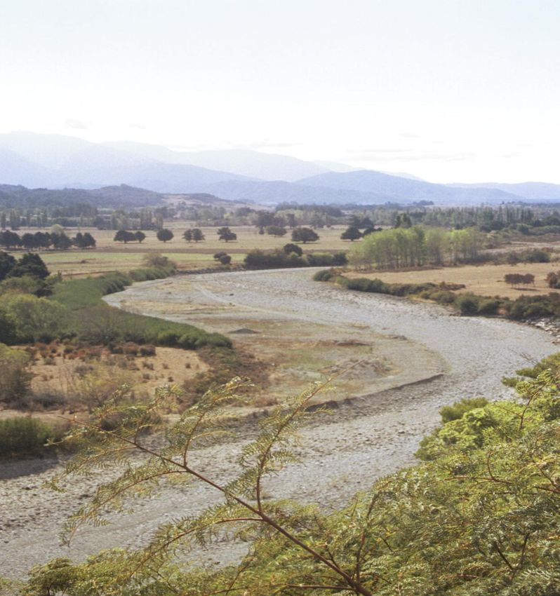
1.3 Consultation
The key agencies consulted were the Department of Conservation, the Tasman
District Council, Fish and Game New Zealand Nelson Marlborough Region, Fonterra
and Manawhenua ki Mohua. A background paper was distributed to a range of
community groups, and a number of local individuals were consulted.
1.4 Social and ecological context
West of the Takaka Hill lies a special place, with dramatic landforms, a relatively
benign climate, and diversity and uniqueness in the rocks, soils, flora and fauna.
Surrounded by National Park land (Kahurangi and Abel Tasman), the human society
derives a living in an equally diverse manner from traditional land and water uses
through to services that support a thriving tourism industry, based largely on
recreation and landscape appreciation with a special feeling for ‘end of the road’
isolation. Although formerly more exploitive, society is strongly conservation
oriented or committed to sustainable resource uses. Identification of and respect for,
iwi concerns is evident.
1.5 Principles of Ecological Restoration
Base actions on Landscape Ecology, which focuses on processes, spatial
patterns and linkages
Restore ecological systems (forests, dunes, wetlands, etc)
Identify interrelationships (land, rivers, the coast)
Make action catalytic, facilitating nature to do most of the work (for free).
2. ECOLOGICAL BACKGROUND
In this section important features of the ecological setting in each resource area
are described, followed by a statement of their implications in terms of
sensitivities and values.
2.1. Topography
A classic medium-sized New Zealand catchment (92,800ha), the Takaka River and its
main tributaries drain alpine headwaters (reaching over 1800m elevation) through a
narrow valley, opening to coastal wetlands (formerly) and estuaries. The headwaters
are often ice-sculptured, and the valley is bordered by outwash terraces of varying age
and fertility. What is special are the geological formations (including marble and
limestone areas, creating stream-less tablelands, underground caverns and associated
sinkholes and springs), the fault scarps, land-slide induced lakes and elevated reefs
and blocks of rock. The unequal disposition of land east and west of the river valley
results from the fault angle depression created by the Pikikiruna Fault: the west is wet
and wild bush-clad wilderness of ancient volcanics, silt and sandstone and schist,
while the east is a narrow band of mostly steeply incised limestone.
4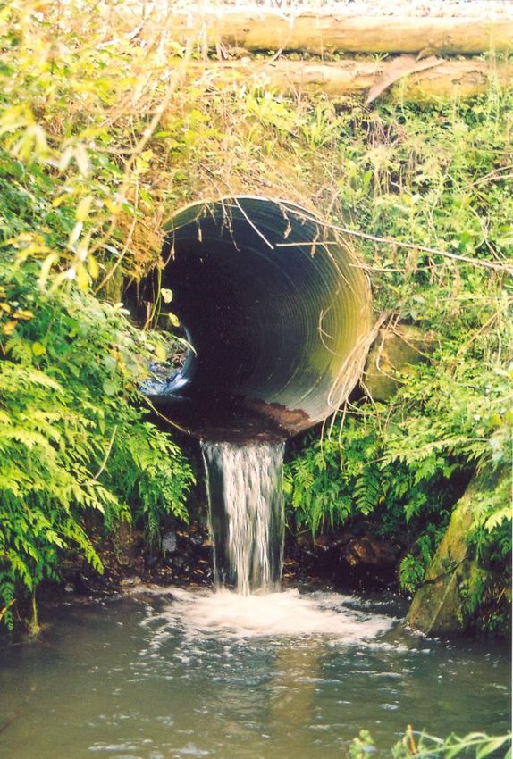
View from Kakapo Peak to Lake Stanley (770m) and Devil Range. The lake was formed by the 1929 Buller
Earthquake which caused a landslide (beyond the right foreground) along the line of the Haupiri Thrust on
the lower flank of Mt Snowden (1859m), the highest point in the Takaka Catchment. A “thrust” is an old low
angle fault that probably left a zone of unstable rock in this area. While an active topography, the geology is
ancient Paleozoic volcanics, silt/ sandstone and schist. Bushline is between 1400 and 1500m. Copyright,
Skylark Productions.

On this topographic diversity rests the ecosystem and species diversity of the flora
and fauna. The preservation and restoration of special landforms such as terrace
sequences, karst topography (including sinkholes), wetlands and estuarine margins,
including their natural vegetation cover, is especially important.

                                                                                                                  5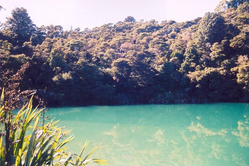
The Takaka River and its catchment. There are several notable features. The fundamental role of the Pikikiruna Fault,
means that the eastern side of the catchment has short streams draining hills while the west has long rivers draining
mountains. The catchment is predominantly mountainous with the valley (where everyone lives) a small proportion.
Mountains in the SW have been glaciated (resulting in outwash terraces in the valley) with tarns. The three main rivers
and several smaller rivers all link in the lower valley creating a distinct flood plain. A small but diverse coastal zone
between Rangihaeata and Abel Tasman Head is strongly influenced by the river, which brings nutrients into the sea, cuts
cliffs at Rangihaeata, deposits silt on the seabed and sand for building dunes, and has cut low-lying areas that have been
reflooded to form tidal estuaries.

                                                                                                                         6
2.2. Geology

The Takaka catchment includes New Zealand’s oldest fossil-bearing rocks (early
Cambrian limestone) through to the youngest riparian and coastal sand. Volcanic
(basalt, andesite and ultramafic-including asbestos,) and metamorphic rocks (schists,
granite, marble) are associated with the sedimentary layers. Pikikiruna schist is a
rock-type unique in New Zealand, derived from metamorphosed quartzite. Oolitic
limestone, or oolite, in the Devil Range, is also unique in New Zealand, consisting of
limestone granules with a concentric shell structure around a grain of sand or fossil
fragment acting as a nucleus. Fossil bearing limestone and calcareous mudstone form
patches in the lower country, often associated with narrow beds of coal. Suites of
outwash terraces line the valley. Paleozoic, Tertiary, Pleistocene and Recent
formations have all been fragmented, elevated and eroded into an incredibly complex
pattern.

The chemical and physical properties of the rocks underlie the evolution of the
landforms and soils and form the basis of the character and diversity of existing
habitats and ecosystems, including local endemic species. Some of the geological
structures have intrinsic value themselves and need to be protected from unwarranted
disturbance and despoilment from weeds and pests.

2.3 Climate and weather

With strong altitudinal and east-west gradients there is no single pattern of climate
and weather. But the central New Zealand location and the rain-shadow impact of
mountains mean that the climate is generally sunny (2200 hours in the lower valley)
and protected from persistent southerly or westerly winds. Rare high wind is capable
of felling isolated trees in the valleys. Rainfall is generally high, ranging from about
1200mm in the NE to over 5000mm in the western ranges. However, summer drought
is a feature (for instance 1973, 2001) and periodically has great impact on vegetation.
Likewise, heavy rainfall is possible, reflecting a “west coast” affinity, with flooding
of the lower Takaka valley and slope instability in the mountains, hills and river
valleys. Frost is a significant feature of the valleys, but there is a strong maritime
influence as well, so that some warm temperate species can extend well inland.
Overall, the weather can be described as benign, but dramatic with occasional extreme
events.

The stand out feature is the high rainfall combined with high sunshine. From an
ecological restoration perspective, however, drought, flooding and frost are important
cautionary considerations within this generally permissive environment.

                                                                                       7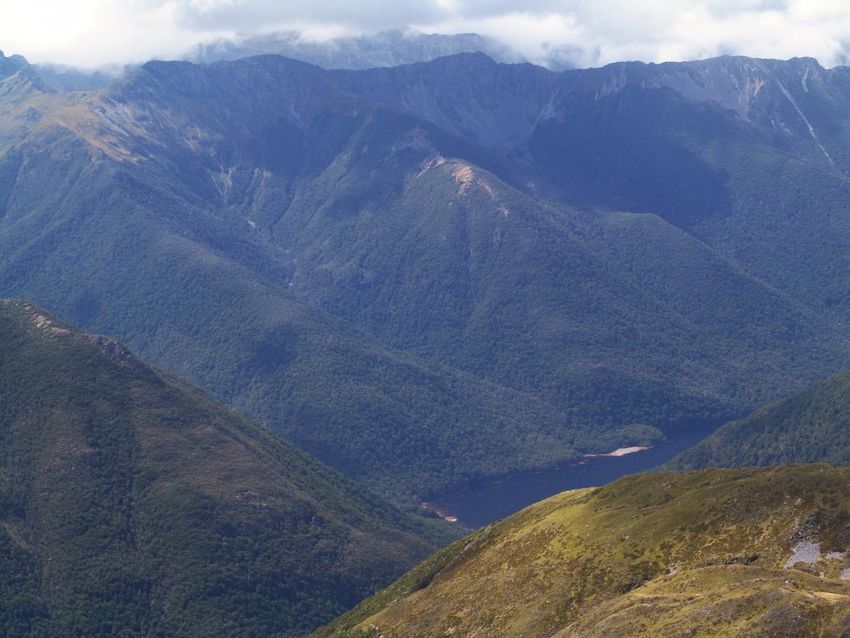
Rainfall is lowest in the NE (1200mm) and greatest along the western ranges especially near Parapara
Peak (over 5000mm). The Valley lies in a rain shadow. Most rain falls in spring and autumn from the
north to west frontal systems while winter southerlies bring snow to the ranges. Any month can have
heavy rain, dry periods or snow.

                                                                                                   8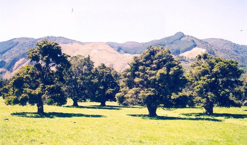
2.4 Soils

High geological, topographic and climatic diversity means that soil chemistry and
structure is equally diverse, resulting in a complex pattern of natural communities
(although this pattern is seriously disrupted across the lowlands, as described below).
Endemic calcicol (calcium tolerant) plants feature in limestone and marble areas. Acid
tolerant species feature in schist and granite areas. Leaching of older outwash terraces
has led to a pakihi-type vegetation, originally featuring trees like yellow-silver pine.
The fertile free-draining alluvial valleys are characterised by totara forest, while the
flood plains of the lower valley are (or were) characterised by kahikatea and pukatea
swamp forest and harakeke (flax) wetlands. Tidal flow results in salt-tolerant
estuarine vegetation around the coast.

These variations need to be reflected closely in restoration planting, not only to
maintain the natural pattern of diversity but to guard against failure, which is costly in
terms of resources and opportunities. The generally fertile soils, often open, rocky
character of the landforms and equable climate also mean that weed growth can be
rife and wild animal populations (goats, possums, pigs, predators) a threat.

2.5 The aquatic environment

The fault angle depression created by the Pikikiruna Fault along the eastern side of the
Takaka Valley plots the general courses of the five main rivers of the Takaka
catchment: the Takaka (including the Cobb) River, the Waingaro, the Anatoki, the
Waikoropupu and the Motupipi. These river systems create the landforms and link the
mountains and hills to the sea. However, within this beautiful pattern lies the unique
feature of the Takaka hydrological environment, the limestone- and marble-based
pattern of underground caverns, springs, and surface karst features of terrain, holes,
caves, dolines (sinkholes) and dry rivers. It is this combination of features that sets the
Takaka catchment aside as one of the hydrogeological gems of New Zealand, if not
the world. Associated with this world of hidden habitats are unique species of animals
(see below).

2.5.1 The Takaka River system
The upper reaches of the Takaka, Waingaro and Anatoki rivers are pristine, stable
systems originating in ice-sculptured rocky peaks with tarns and sometimes rock
avalanche lakes (such as L. Stanley, formed after the Buller Earthquake of 1929),
snow tussock grasslands, scrublands and herbfields, descending through extensive
beech forest into deep gorges before debouching onto the lowland plains. These
headwaters form the core of Kahurangi National Park and are a recreational treasure
as well as a nationally significant centre for biodiversity, especially among alpine
plants such as Hebe. The Takaka River, once it reaches the valley begins to lose water
through the alluvial gravels and into the cavernous marble beneath the valley. When
the flow is less than 9.4 cubic metres/second, part of the river is dry, and only reflows
near the confluence of first the Waingaro then the Anatoki. Becoming dry obviously
poses serious ecological constraints on both the aquatic ecosystem and the riparian
land along the river, because there are limits on water availability, fluctuations in
temperature and restricted flushing of aquatic pests. (Didymo, has been recorded
throughout the Takaka River.) Contrary to popular belief, the Cobb Power Scheme

                                                                                         9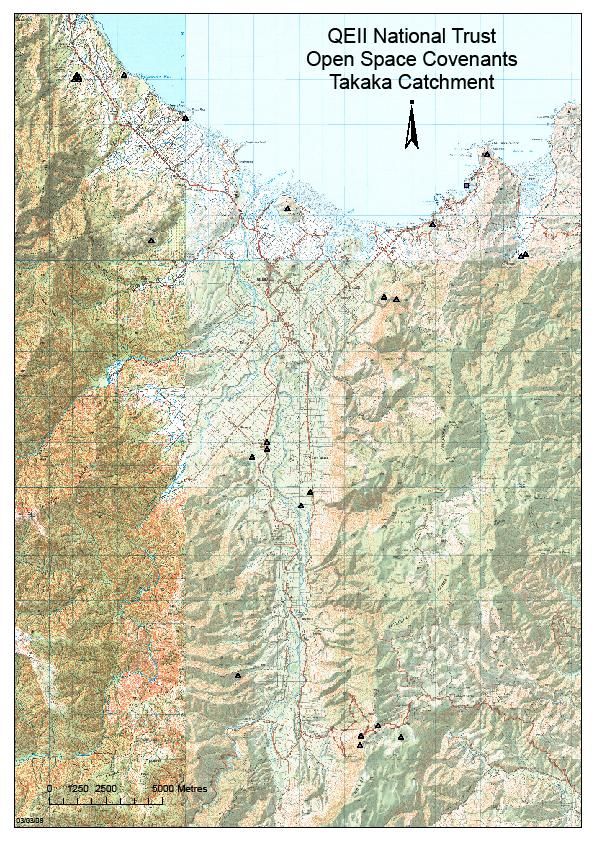
actually reduces the time the river is dry, by releasing water during dry periods. The
lower Takaka River is tidal and the river mouth has created a delta of high ecological
value.

The wilderness character of the upper catchments means that species that are rare
elsewhere can survive, unless introduced pests are an issue. This is the case for whio
(blue duck) in the Flora catchment (a tributary of the Takaka) and strenuous efforts to
trap predators by the Friends of Flora and Friends of Cobb, partly funded by the Cobb
Mitigation Fund, are paying off. Similar controls on possums, deer and pigs will
ensure the survival of rare endemic plant species, such as Dall’s pittosporum. There
are opportunities to enhance populations in the vicinity of the dam and reservoir.

Whio chicks born on the Flora Stream, 2007, following intensive predator control. Department of Conservation

On the activity of rivers: Simon Walls writes (PNA report, DOC 2000, unpublished,
page 13): “ Constant fluvial processes have sorted alluvium, added silt layers to
floodplain surfaces, changed river channels to leave oxbow lakes, added and removed
riverbanks, re-worked older gravels, inundated sinkholes, sliced the ends of lateral
fans, cut into the fault angle rocks on the valley sides, built complex deltas, scoured
steep sided gorges in hard rock and contributed vast amounts of material to coastal
areas.” It is important that, within the confines of common sense, these processes are
enabled to continue.

2.5.2 The Cobb Reservoir, Dam and Power House
The Cobb reservoir was filled in 1955, designed to collect water in wet events and
gradually release the water during summer dry periods, enabling a 32MW electricity
generation. The spillway is overtopped several times a year, averaging 8, but the
minimum control level has been exceeded only once, during the very dry year of
1973. Peak flows in the Takaka River today are similar to the previous natural peak
flows, with a tendency towards a longer duration because outflow from the dam is

                                                                                                               10
less than inflow to the reservoir. The number of occasions that the reservoir will spill
over is predicted to decline if electricity production is increased beyond 32MW.
Major floods are important in a river system because they ‘re-set the hydrological
clock’ by filling the nooks and crannies and flushing the channels. Such an event
might be important in future for the natural control of didymo. The natural drying up
of the central valley river is little changed by the action of power generation except
that when the threshold for drying is near power generation will cause temporary
reflow. Overall the duration of drying is reduced 60 days/year by the addition of more
water. The power station and dam obviously block the river to both upstream and
downstream movement of aquatic life and translocation of elvers and mature eels has
been suggested. The reservoir is the largest body of water in the Takaka catchment
and serves as a significant recreational asset requiring good quality road access into
the alpine area. In an area with many lakes formed by landslides, Cobb Reservoir
could be similarly regarded, only of human origin, but with all the natural qualities of
similar lakes such as Lake Stanley (the second largest water body), which has a land-
locked population of koaro.
The Cobb Reservoir during the 2000-2001 summer drought. The power scheme has
an operating water level range of 13.7m and the level at this time was 794.25m asl., just
below the minimum operating level. The dam prevents movement of fish into or from
the reservoir. (Photo courtesy of Georgina King, Environmental Management
Services Ltd, Napier, 2001).
2.5.3 Arthur Marble and Takaka Limestone caves and aquifers
A paleocave system developed in the Arthur marble during the formation of the NW
Nelson peneplain in the Late Cretaceous and Early Tertiary. Tectonic movements
11Barbara Sparrow at the entrance of a limestone cave near her Uruwhenua property. This cave
was ‘lost’ within a pine plantation and a bull-dozer was driven over the entrance during
harvesting. It is about to be ‘lost’ again. Such events highlight the sensitive nature of caves. The
vegetation around caves needs to be stable native bush, fostering a healthy cave hydrology,
atmosphere and food supply for cave animals.
have reactivated this cave system so that it now contains over one cubic kilometre of
water, most of which emerges at the Waikoropupu Springs. Interacting with this
aquifer is a similar but smaller hydrocave system within much younger Tertiary
limestone that overlies the marble. It is recharged by rainfall and seepage from the
eastern hills, and emerges in a series of springs along East Takaka and near Paynes
Ford. These small springs have generally been disturbed and restoration of their
natural vegetation is desirable. The karst caves of the Takaka catchment are world
famous for cavers (including Harwoods Hole and Moonsilver) and there are several
small systems accessible by the general public for observing the beautiful limestone
formations that form in the absence of disturbance. The limestone caves are also the
home for several unusual animals, including some sap sucking insects that live off
plant roots, and New Zealand’s largest spider is known only from a cave at Motupipi
12and a similar site in north Westland. They also have great scientific value for their
subfossil bird, frog and invertebrates remains. Restoration of vegetation around cave
entrances is a good way of enhancing the values within, especially if native forest
influences the hydrology, atmosphere and cave species.
Takaka River from the East Takaka Road during a dry period (from Cawthron Report 635, 2001). River water flows
through the surface gravel and into underground channels in the limestone. This is a natural phenomenon, but has
substantial impact of aquatic life. Vertebrate and invertebrate migration is disrupted and the shallow and sluggish water
above the dry zone encourages the growth of algae.
2.5.4 Waikoropupu Springs
To iwi, the Waikoropupu Springs represent one of the most important taonga
(treasures) in Aotearoa. The springs are waitapu (sacred waters).
13With a mean flow of 13.2 cubic metres/second, the ‘Pupu’ Springs are the largest in
New Zealand, issuing very pure water from the Arthur Marble aquifer. Although most
of the water is several years old the flow does respond to rainfall and river flow (in
the Takaka and Waingaro) and water quality could possibly be influenced by surface
features. The rate of decline of groundwater level in some wells is broadly related to
the rate of decline of spring flow, suggesting that a high level of extraction could
influence the spring flow. There is also some influx of seawater (0.5-0.7%) from very
deep caverns. The springs constitute one input to the Waikoropupu River, another
branch of which drains hills along the SW slope of Parapara Peak, one of the very
high rainfall zones of the Takaka catchment. The springs’ emergence reflects a high
degree of geological complexity in the area. High rainfall and ‘easy’ outwash terraces
of varying fertility around the springs has led to a cover of pakihi scrub (which is rich
in low fertility-tolerant, often ancient plant species, especially ferns) and wilding
pines, with little original bush remaining. The Motupipi coal measure is an
impervious cap over the marble. Where it occurs on the surface it is erodible and
infertile and contributes to the unusual ecological character of the area.
The lower Waikoropupu River including the Springs and their immediate
environment emerges as a high priority place for ecological restoration.
2.5.5 The Motupipi River
The Motupipi is a small river system with a curious mix of components. Much of the
catchment rises in limestone, forming spectacular gorges along the eastern hills with
streams flowing only during rain events. Part arises as springs on the lower flood
plain almost within the Takaka urban area. The Takaka River has probably
overflowed into the Motupipi. The river meanders across fertile dairy flats and is a
source of concern over water quality. It opens into a double estuary bisected by the
‘island’ Motupipi itself, a remnant of the Motupipi coal measure deposit, with unusual
forest composition. The area has important historical associations for both Maori and
Pakeha, is currently a favoured whitebaiting river and provides many opportunities for
ecological restoration.
2.5.6 The coastline
The coastline considered relevant to this report on the Takaka River catchment
includes the following elements:
the eastern side of Rangihaeata Peninsula,
the Takaka River mouth, tidal reach and delta
Waitapu estuary
Rototai Beach (including the Sopers Hill schist dome)
Motupipi estuary (including Rototai and Clifton sections)
Pohara beach, including a sand spit
Limestone Bay (including Tarakohe), coastal limestone bluffs
Ligar Bay- Tata Beach, beaches, estuaries and granite headlands. (The
limestone Tata islands lie off-shore)
14The delta of the Takaka River has been formed by numerous separate channels. The river has flowed hard against the
Rangihaeata Peninsula and cut cliffs along its eastern flank. The river is tidal and large areas form estuary. Adjacent to
some inland channels the flood plain supports small areas of dense forest, including totara, kahikatea, pukatea and rata.
An artificial channel carries water directly to the sea and some of the old channels are silting up. Much of the flood plain
is farmed, mostly covered by a treeland of the above species as well as kowhai. On the adjacent hill-slope of inland
Rangihaeata there is a remnant of near -natural beech (hard, black), podocarp (rimu, kahikatea, matai, miro and totara)
and rata forest. The delta offers quality recreation experience.
All these places have been severely impacted by one or more aspects of development,
roading, subdivision, drainage or weed invasion. Yet, this is an ecologically
productive zone and parts have intensive tourist, historical and landscape value. There
are unlimited opportunities for ecological restoration. Coastcare in Golden Bay (part
of a national programme developed by the Dune Restoration Trust of New Zealand)
has been involved in many dune and coastal slope plantings of native species (such as
spinifex and pingao in place of marram), pest and weed control and education.
Administered by TDC, Coastcare is funded by land development levies and while
focussed on reserve land is also able to extend into private land on a voluntary basis.
2.5.7 Takaka River Management
(The following information is from Webby et al., 2000: Takaka River Catchment
Flooding Study, TransAlta New Zealand Ltd.)
The amount of annual expenditure by TDC on channel maintenance works is
considerable (1996/1997 - $96,000, 1997/1998 - $127,000, 1998/1999 - $164,000).
This reflects the steepness of the river bed (average slope 0.32%) and the
consequential aggressiveness of flood events as they travel downstream. Damage to
banks typically occurs as a result of the maximum annual flood event, which has a
peak discharge in the range of 207-689 m3/s at Harwoods (1975-1999)
and 578 -1226 m3/s at Kotinga Bridge (1970-1999). However, the damage that occurs
is not necessarily due primarily to the magnitude of the peak discharge but rather the
duration of the high flows (and hence flow velocities) coupled with the antecedent
ground moisture conditions.
15The types of bank repair methods used in the Takaka River comprise rock revetment
work, rock groynes, willow planting and occasional placement of toe rock only with
willow planting on top. The annual maintenance expenditure is typically split roughly
equally between rock work and willow work. However, following the major July
1998 flood event the $164,000 expenditure on damage repairs was split approximately
two thirds and one third between rock work and willow planting respectively.
Crack willows have long been used in bank stability but have never been very
effective because they grow too fast, too large and fall over. Smaller bitter willows are
now favoured, with periodic ‘mowing’ to maintain a dense growth capable of filtering
silt and flood debris out to limit damage to fencing. Crack willow is targeted for
removal, offering opportunities for native riparian species.
Gravel removal from the river bed beaches has been routine for many years but is
becoming replaced by a ‘sustainable river system’ which prevents gravel removal but
allows moving gravel to minimize damaging water flow. The sustainable river
concept enables the multiple uses of the rivers to be more integrated, with farm
production, water, trout (Fish and Game), habitat and biodiversity (Conservation,
Forest and Bird), recreation and landscape all with potentially competing interests. An
over-arching philosophy towards river management is embodied in the concept of
Integrated Catchment Management (ICM)
At the time of European settlement some of the river had a crown strip (20m) along
each bank. However, movement of the channel over time has eradicated most of
these. Today, most of the riverbank from the mouth to Upper Takaka is privately
owned. While land owners are currently positive towards granting access for fishing
or swimming, informal arrangements carry no guarantee, and this is something that
Fish and Game New Zealand are concerned about. Competing interests are strongly
encouraging the re-establishment of riparian reserves and this process also offers
opportunities for native plant establishment.
2.6 Vegetation and Flora
While some local extinctions may have occurred since human occupation of the area
(for instance, pakihi podocarps, maire and pingao) the floristic composition is largely
intact. However, the vegetation has been extremely modified, with virtually all land
below about 500m (and sometimes much higher) cleared for timber and farming,
drained or invaded by introduced species. Clearance has been most intensive on flat
land, sunny aspects and relatively easy hill-slopes, while the shaded steep mountain
valleys and ridges have remained largely untouched – 60% to 70% of the catchment,
most of it now National Park. A discontinuous rim of original vegetation remains in
private ownership between the conservation hinterland and cleared lowland farmland.
There are major opportunities for ecological restoration throughout the lowland zone
including forests, wetlands, estuary margins and coastal sand vegetation.
2.6.1 Pre-human vegetation pattern
The main natural factors influencing vegetation pattern are altitude (temperature, frost
and rainfall), history of disturbance (landslides, floods, wind and snow storms,
16drought), soil chemistry (acidity, nutrient availability) and physical character
(structure and moisture).
In the Takaka catchment a narrow band of coastal vegetation occupied the rocky
bluffs, sandy beaches and dunes, estuaries, tidal reaches of rivers, and wetlands.
Extensive fresh-water wetlands (harakeke, cabbage trees) occupied the lower valley,
gradually giving way to swamp forest composed of kahikatea and pukatea. Beech
forest (black and hard) extended to the coast in suitable places and northern rata forest
was widespread. On drier alluvial soil, totara forest was widespread with a mix of
flood plain species such as ribbonwood, narrow leaved lacebark and tawa. Beech was
a component of this forest with kowhai in open places along streams and on bluffs. A
warmer thermal belt with reduced frost allowed coastal species to extend well inland,
such as nikau, akeake and titoki. With increasing altitude beech forest became
continuous composed of hard, red and silver beech, this extending to bushline
between 1300 and 1400masl. The forest was interrupted in places with wet soil or
exposed rock outcrops, especially limestone and on these surfaces a range of local
endemic species occurred. On wet outwash terraces pakihi forest including yellow
pine, pink pine and silver pine occurred. Above natural bushline a mix of shrubs,
snow tussocks and herbaceous plants occurred according to soil moisture, rockiness
and aspect, with snow an important influence, including avalanches into the bush.
This vegetation was especially rich in species as a result of the geological and
landform diversity, and relatively limited impact of recent glaciation.
The composition was also greatly influenced by the central New Zealand location and
associated natural conditions. The rich physical environment enabled a full suite of
typical widespread species to flourish, as well as many typically uncommon New
Zealand plants like fierce lancewood. Several species approach their southern or
western limit in the catchment or nearby, such as cedar, tanekaha, milk tree, NZ privet
(hangehange) and tawa. Others reach their northern limits from a wider distribution
along the Southern Alps, such as many species of Hebe and Celmisia. Still others are
local central NZ species such as Scutellaria novae-zelandiae and there are many
locally endemic species based on the distinctive soils especially limestone, such as
Hebe albicans. (A list of threatened species is maintained by DOC, see Appendix II)
17Remnants of original forest are important in many ways: they indicate the natural pattern of
vegetation and soils; they protect unmodified soil beneath them; they are habitats for flora and
fauna above and below the ground; they are templates for restoration and they are a genetic
source for propagation. They reflect aspects of human history too, in this case use of the inner
bark by Maori inhabitants during the 19th Century to make a patua, a basket for preserving
birds such as kereru and tui, an archaeological taonga now very rare in the Takaka catchment.
18This intricate pattern offers unlimited opportunities for restoration for it has been
largely displaced throughout the lowlands. Riparian areas offer particularly favourable
environments for restoration owing to their open character and moist, often low-frost
conditions.
2.6.2 Current vegetation pattern
The main features of the current pattern of native vegetation include:
places that have been left intact because of terrain, such as limestone bluffs
and estuaries;
valley remnants that have escaped logging and fire usually because of
steepness and shading;
small valley floor remnants kept for intrinsic value or as sustainable resources
by original and later settlers;
regeneration of new vegetation such as totara forest, bracken fern, kanuka,
manuka and broad-leaved species such as tree ferns, whiteywood and five-
finger on hill-slopes and wet terraces. Secondary vegetation is particularly
widespread on the western hills above the Takaka valley and is, in general,
well on the way to becoming forest, albeit with a range of introduced species
such as pines.
Introduced species are particularly prominent along coastal sand (marram
grass), river-banks (willows), rock outcrops (banana passionfruit) and roads
(old mans beard) and many represent escapes from gardens (cotoneaster).
Remnants are highly valuable templates to copy, sources of plant material and
opportunities to sustain natural processes, such as restoring water quality. Naturally
regenerating native vegetation can be managed to remove invasive species such as
wilding pines. Wild animal control (pigs, possums and goats for instance) is necessary
as part of the regeneration process. Returning lost species is a major opportunity: for
instance pingao and spinifex to coastal sand dunes; harakeke and Carex secta to wet
areas (or areas that can be made wet by re-watering); tawa, northern rata, narrow-
leaved lacebark and ribbonwood to alluvial forest.
Owing to the special character of the Takaka flora and vegetation, ‘eco-sourcing’ - the
propagation and planting of local plant material only - is extremely important.
The classification of Land Environments (LENZ) offers an approach to broadly
prioritise places for ecological restoration (see MAP of LENZ units Appendix III).
2.7 Fauna
Like the vegetation, the fauna has been dramatically changed by human impacts. But
unlike the flora, extinction has been common, especially among birds. Harvesting,
loss of habitat and the impact of introduced predators are the main reasons for loss.
Wetland birds are particularly vulnerable from loss of habitat, including marsh crake,
banded rail and Australasian bittern. Blue duck is restricted to a few mountain streams
as a result of predation. Forest birds such as kereru breed with difficulty owing to
19predation from rats, stoats and possums. The western weka has declined dramatically
in recent years for unknown reasons but habitat disturbance and predation are likely
impacts. Coastal birds including little blue penguin, reef heron and little pied shag, are
in decline as a result of disturbance in their coastal habitat.
Freshwater fish are present in virtually all the waterways of the Takaka catchment
including small farm drains with low water quality. Shortfin and longfin eels are
widespread, as are inanga. Some species such as koaro and kokopu, are sensitive to
disturbed environments and prefer waterways with vegetation cover and a diversity of
habitats. Migratory species are impacted by blocked passages from culverts and dams.
Many waterways have been straightened and cleared of vegetation (influencing
temperature, nutrient status and habitat diversity). Wetlands (where inanga mature)
have been seriously reduced, and spawning sites are exposed to stock disturbance and
land development.
Evidence suggests that where these impacts are removed the fish population responds
well, so restoration activities such as riparian planting will have benefits. Introduced
aquatic weeds (for instance Lagarosiphon major) impact on water quality by reducing
oxygen and smothering food sources. The long-term impact of ‘Didymo’ is yet to be
determined but recreational activities such as boating, diving and fishing pose a major
risk for spreading it throughout the catchment. Aquatic weeds are most prolific where
sunlight has access to the water body, the flow-rate is reduced and nutrients such as
effluent runoff enrich the water. All of these aspects provide opportunities for
ecological restoration with regard to the aquatic fauna, including invertebrates.
The invertebrate fauna of Takaka is renowned for two reasons: the several species of
large landsnail, Powelliphanta, and the limestone cave fauna. Landsnails are being
severely impacted by predation from wild pigs. The cave fauna appears relatively
secure but there is an issue relating to their food preference - the roots of trees
entering the cave. Native species may be preferable.
Habitat creation, predator control, weed control and habitat improvement to remove
restraints on migration, breeding and food supply are all possible restoration activities
relating to the fauna. Moving animals to secure habitats, especially birds, snails and
fish, is also possible. (Moving fish from shrinking pools in the naturally drying
Takaka River has been a common practice for years.)
3. LANDSCAPE
Landscape is the synthesis of natural and human environments. It offers a window to
our identity and a check on how we are doing. Few would dispute that the landscapes
of the Takaka catchment are special. The combination of landform, colour and light,
the interactions of land and water, especially the sea, the prominence of rocky
outcrops, and the juxta-position of farmland and natural features such as trees and
mountain wilderness, are simply pleasing. There are some eye-sores - straightened
waterways, geologically polluted coastline, gouged hillsides, poorly positioned
buildings, exposed tracks, and weed infested vegetation - to name a few.
20A particularly relevant initiative has been “Trees on Farms”, whereby the trees typical
of the valley floor - totara, black beech and kahikatea, for instance, have been planted
in groves or as specimen trees. The totara groves of Takaka valley are special, but
with time exposed trees die, and the occasional drought and wind has an impact.
Large old primeval trees from the prehuman forest are rare and particularly
vulnerable. For the landscape character of the farmland to be maintained, trees need to
be planted. Roadsides, farm shelter and waterways offer opportunities for tree
planting.
New Zealand’s unique rare cave spider (Spelungula cavernicola), is found only from limestone caves in Takaka and Oparara. Its
body length is 25mm and legs span up to 30cm - our largest spider. It catches its prey (such as cave weta and flies) on the
ceiling or by descending from a drag-line. The vegetation around the cave entrance and immediately above the cave is vital to
maintain a healthy environment for the cave fauna. Photographed by Grant Stirling (Stirling Images)
Te Papa image
21Apart from wetlands, bluffs and parts of the coast, the Takaka Valley was originally densely
clothed in tall forest, mostly totara, kahikatea or beech, depending on the soil. During the late
19th Century, virtually all this forest was cleared for farming, and in the period immediately
after, when rough ground was widespread and grazing less intensive than nowadays, new trees
established - groves of kahikatea on the lower flood plain, scattered or dense totara on the drier
alluvium up-valley. While the mature trees are resistant to grazing no new trees can establish
and eventually the old trees will die: gradually this important rural landscape is losing its trees.
A ‘mountains to the sea’ philosophy also offers insight into the inter-relationship of
habitats along a sequence. Landscape ecology is a discipline that explores ecological
processes at a landscape scale investigating the values of corridors, shapes of natural
features and their age and density. Interactions between public conservation land and
surrounding private land are particularly relevant when ecological restoration is a
possibility. Landscape planning at a property scale and between properties could
underpin restoration actions, with stream stability and high water quality major
objectives.
3.1 Recreation and interpretation.
For many people the Takaka catchment, at least the lowland part of it, is not
especially user-friendly for outdoor activities such as biking and walking, or learning
about natural places through interpretation facilities. There are notable exceptions,
such as Waikoropupu, both the springs and the Pupu hydro scheme walkway. There
are other initiatives such as planned cycle-ways, one of which follows the old
tramway built to carry logs from East Takaka to Waitapu. An important part of
ecological restoration is public support and understanding. Project Crimson’s “rata
trail” is an example that encourages participation. There are many other opportunities
to create interpreted trails.
224. ECOLOGICAL RESTORATION PRIORITIES
Whatever enhancement actions are undertaken, they need to be consistent with
the policies and work programmes of the Department of Conservation (DOC),
and the Tasman District Council (TDC), although in both cases changes in
public opinion can motivate shifts in how and what actions are taken. Staff at
DOC specialize in environmental management and could be consulted for
technical input.
Some of the enhancement actions funded by the Cobb mitigation fund will be
carried out by community groups (e.g., Friends of Cobb) and take place on the
DOC estate, and therefore will need to complement the ongoing DOC work
programme, particularly with regard to predator control.
The specific examples cited below have not been checked for feasibility or
conflict with local government policies and practices, or landowner desires or
capacities. They are suggestions that have emerged during consultation. Any
further action will need to be negotiated with the appropriate parties, and the
practicalities, including economic aspects, worked through.
4.1 Generic issues and specific examples
4.1.1 Secure and maintain existing natural biodiversity
DOC carried out a Protected Natural areas survey in 2000 and identified a number of
natural areas worthy of protection in the Golden Bay Ecological District (which
covers most of the private land within the Takaka Catchment). This survey has never
been implemented. An informal voluntary Significant Natural Areas (SNA)
programme is being implemented by the TDC, with selected volunteer properties
being surveyed over the last few years, but with hopes for a more comprehensive
survey in future. Many landowners are protecting natural areas themselves or through
covenanting via the QEII (Appendix IV). All surviving natural areas contribute
immeasurably to the ecological character of the catchment. Surveying, fencing, weed
and pest control and species enhancement are all required in innumerable small
natural areas on private land and these initiatives require funding. Although the very
best of these natural areas may be formally protected, in general conservation
management is the important factor.
o Wetlands: Existing fragments of wetlands need to be protected from
stock and rewatered if necessary.
o The Mitigation fund could be used to create wetlands by excavation.
Sometimes the gravel removed can be used to off-set the cost. Heavy
rain reveals part of the network of former wetlands across the lower
flood plain and any of these could be enhanced to recreate an effective
pattern of wetlands. River backwaters offer other possibilities, while
sealing sinkholes also has potential. Planting appropriate native
vegetation within and around created wetlands is also a valid use of the
fund.
4.1.2 Managing the karst environment
Weeds, protecting landforms, karst landscape, interpretation of karst geology,
restoring populations of calcicol species and plant communities on limestone
23outcrops; pest control; restoring water and vegetation to sinkholes, understanding the
underground fauna (such as the pupu flatworm which has been seen only once).
o Removal of parrot weed (Myriophyllum aquaticum) from Lake
Killarney
o Dietary analysis of cave sucking insects to determine optimum (native)
vegetation to restore around the cave entrance
o Restore springs such as Spittle Spring and others at East Takaka,
Spring Brook, Windles near Paynes, Watercress Creek Motupipi,
Maori Rd springs. All these springs are ideal for rehabilitation by
planting around them the original species (such as kahikatea, matai,
totara, kowhai), keeping stock out, removal of weed species.
Blue Lake at Rototai is one of the very few sinkhole wetlands with forest around it and serves as a model for restoration.
The forest is secondary kanuka with regenerating black beech, kahikatea and rimu. The lake margin supports a stand of
kuta. The blue colour of the water is thought to be derived from sulphides that leach from the Motupipi coal measure that
overlies the limestone here.
4.1.3 Fresh-water fish habitat
All riparian plantings are important, with a focus on small creeks around the coast.
The lower Waikoropupu River, including Spring Brook, is a priority for restoration.
Inanga need flax swamps to mature in and secure places for spawning. The most
important place for spawning is vegetation (flax, kuta, toetoe and other, even
introduced grasses, sedges and reeds,) at the head of the Spring tidal wedge. The long-
fin eel is declining. A handbook on methods to build fish passages is needed. ( A file
on blocked waterways is maintained by TDC.) There are many cattle crossings
through small streams that could be culverted. Fencing of small streams (e.g., Ellis
Creek) is important for galaxiids. Long-fin eel elver capture from the Cobb Power
24Station for transfer to the Cobb Reservoir is feasible (Strickland, R. 2001: Cobb
Power Station Elver Study, Cawthron Report No. 621).
25This culvert under a driveway across a small Pohara stream completely eliminates the passage of most native fish because
it overhangs both the water and surrounding wet ground. It needs a rock or concrete ramp up which poor climbers like
inanga can swim.
264.1.4 Partnership with Manawhenua ki Mohua
The time has long gone when activities that significantly modify the land or water can
be undertaken without regard for previous inhabitants and the views of existing
manawhenua.
o It is necessary to secure, restore and sustain places for the traditional
Maori harvesting of plant materials such as kuta, harakeke, kiekie and
pingao (and possibly animal (for instance fish) and earth products), to
avoid damage to archaeological sites and traditional landscapes, and to
consult when planning potentially important resource developments.
o Land agreements as a result of Top of the South claims to the Waitangi
Tribunal may identify opportunities for ecological restoration.
4.1.5 The Takaka River riparian zone
o The river mouth delta is a magnificent place with estuary, sandy
beach and rocky shore in close proximity and it requires a plan to
identify restoration opportunities such as weed control and planting.
o Te Kakau Stream (an old Takaka River channel), has serious
Lagarosiphon , which reduces the oxygen level, and requires shading
by fast growing native trees such as wineberry, tutu and karamu.
o Restoration areas along Takaka River include stretches above Lindsay
Bridge ( where crack willow is being removed, near Murrays Beach),
below Lindsay Bridge adjacent to the Uruwhenua reserve, between
Paynes Ford and Kotinga Bridge, the ox-bow area above Paynes Ford,
and no doubt many other small stretches of reserve or private land.
Based on TDC Department of Engineering policies, Sicon is contracted
to carry out willow management along the Takaka and associated
rivers. The contract and the schedule of work is headed by John Ellis
(Tapawera) and Alan Sowman (Takaka) and these are the persons
whom prospective applicants for funds to plant natives should contact
for opportunities and site details.
o Public access to the Takaka River is limited because there are few
marginal strips. A cycle way along the former tramway (built in the
1890’s to carry logs from East Takaka to Waitapu wharf) is planned in
the Ox-bow area and will require a buffer of native forest. TDC has
identified “indicative walkways”. Fish and Game New Zealand
consider that a valid use of the Cobb Mitigation Fund is to assist with
formal negotiations with land owners to buy narrow riparian strips of
land (say 5m across), or to negotiate formal agreements like covenants
that are transferable on the Title.
o Where river protection planting is required flood plain native species
could be used instead of willows. Cabbage trees have been
progressively dying (from Sudden Decline, as well as old age and
stock damage to trunks, and lack of regeneration), and a planting
programme is needed to restore this iconic flood plain-wetland species.
Native species with fibrous root systems would be favourable for use
in flood prone areas (Appendix VI) However, sometimes introduced
27forest species (willow, sycamore) have created an ecosystem with
habitat value and within which there is progressive native regeneration.
28The aquatic weed Lagarosiphon in Te Kakau Stream adjacent to the Takaka
township, is so dense that oxygen is depleted and other life is nearly impossible.
The weed can be controlled by matting or spraying, but the long-term solution is
to revegetate the banks using fast growing native vegetation ( cabbage trees,
flax, karamu, wineberry, whiteywood) to shade the banks, reduce the
temperature, and foster native aquatic species. Photo: Trevor James, TDC
o Restoration of riparian vegetation along Motupipi River. Some
macrophytes in the water do a good job by removing nutrients, so
windows of light should be left. The stretch from the Dairy Factory to
Sunbelt Crescent is very visible and messy. Crack willow removal
would enable kayaking along river. The Council reserve includes
pukatea and there may be an opportunity to extend this bush remnant.
(Pukatea seeds prolifically and a secure habitat is needed for re-
establishment rather than necessarily planting- this applies to many
species. A principle for ecological restoration is to provide the
conditions for nature to do much of the work.
o Rototai former rubbish tip site (TDC): coastal forest potential
o Motupipi Spit totara forest restoration
4.1.6 Enhancement of rare or notable plant species and ecosystems
o Silver pine logs have been exhumed in paddocks up the Waikoropupu
valley. This pakihi forest-type is now gone from the catchment and
could be restored based on models from further west.
29This orchid (Orthoceras strictum,, horned orchid) is a representative of the pakihi flora which is well developed in the
Waikoropupu catchment. The low fertililty soil leached by heavy rain supports a distinctive range of species, including
silver pine, now extremely rare in the area, as well as a range of primitive ferns and shrubs such as hutu which otherwise
grow in the wetter country further west. Protection and restoration of lowland pakihi, including removal of wilding pines,
is a priority.
o Reintroduce mistletoe (Alepis, Peraxilla) to valley floor silver and
black beech
o ‘pitpat’ (Pittosporum patulum) at Cobb, dall’s pittosporum at Cobb;
many others along valley floor (tawa, tanekaha, northern rata, black
beech) and coastal forest (ngaio, milk tree). Plant list maintained by
DOC.
30o establish lowland forest on public land at Paynes Ford
o Identify and protect remnant individual or groups of pre-human
trees (totara, kahikatea, matai, northern rata, pukatea, hinau) along the
main valley (possible seed sources, as well as indicating original forest
pattern).
o All coastal ecosystems (especially forest and sand dune, but also the
landward margins of estuaries) require restoration actions. (Coastcare
is active.)
o Tree planting on farms will help maintain the distinctive rural
landscape. It would be appropriate for the TET to use the Cobb
Mitigation fund to revitalise the ‘Trees on Farms’ initiative.
4.1.7 Plant and animal pest management
o “Flood weeds”- Tradescantia, periwinkle and Crocosmia, inhibit
understorey development. Control areas for banana passion-fruit
include NE part of catchment and Upper Takaka.
o Wilding pines have a serious impact on landscape integrity and can
maintain populations on exposed rocks. Elimination is desirable along
both east and west slopes above the Takaka Valley and in the
Waikoropupu catchment. It would be desirable for forest owners to
remove wilding pines after logging, as part of the logging agreement.
o Weed invasion of limestone areas prevents natural species from
establishing - cotoneaster along Pohara coast, barberry throughout,
Italian jasmine, climbing asparagus. Forest and Bird operate a “weed-
busters” programme.
o Willows along rivers each area needs to be assessed independently
because willows have been an important part of river control work and
are not universally regarded as ‘weeds’.
o Predators include possums, stoats, rats and pigs (sometimes
hedgehogs are also identified as predators). Possum control using
aerially applied 1080 is in widespread use on DOC land but, rightly or
wrongly, receives considerable public criticism and alternative
methods are also used, particularly hunting by landowners and
regularly maintained bait stations. This campaign should continue.
Rats and stoats have a major impact of bird reproduction and many
groups and landowners are maintaining trap lines. Wild pigs severely
impact on ground snails in elevated bush areas, and while hunting is
widespread it is not adequate to control pigs and a poisoning
programme is needed as well.
4.1.8 Dairying
o The most intensive land use in the valley, involving fertilizer use on
the pasture, irrigation, concentrated stock numbers, local stock
movement across the farms, effluent disposal from yards and sheds,
pesticide and stock management chemicals, pathogens. Sheep farming
is less intensive overall but can have a similar range of characteristics
and impacts.
31Wilding pines establish in open places where the seedlings can receive plenty of light. This happens when
farmland is abandoned and natural regeneration of bracken fern, kanuka and manuka takes place. Or
pines can grow on slips or rocky places. They spread from mature trees around settlements, shelter belts
or woodlots. The pines grow much faster than the natives. In time they will blow over but fire might well
encourage their return. Hence for the current generation of people for whom conservation, tourism and
recreation is more important than farming unsuitable land, wilding pines interfere with the natural
landscape and their removal (preferably by poisoning) is encouraged.
o “sustainable dairying” is a goal, involving nutrient budgeting to
reduce nutrient runoff, and waterway protection
o the main concerns are nutrient (nitrogen, phosphorus) and pathogen (E.
coli, Giardia, Campylobacter, Cryptosporidium, Salmonella) runoff to
streams and rivers, and ultimately to coastal waters (where there is an
impact on commercial harvest of mussels and other shell fish);
despoliation of streams through pugging and sediment runoff from
stream banks; loss of native habitat (riparian and other vegetation and
wetlands) owing to the need to maximise high grade pasture, and water
extraction.
o small and intermittently flowing streams are the most vulnerable;
maintaining passages for fish migration is important
32o solutions are to keep stock out of waterways by fencing, providing
stock water facilities and bridged or culverted crossings; maintain
dense riparian vegetation of grasses, shrubland, forest or a mix of these
to protect the banks and water from erosion and runoff to the degree
possible; avoid soil compaction, maintain or enhance native vegetation
by fencing, pest management and planting (for instance shelter belts of
mixed native species).
o Funding for minor activites comes from a variety of sources including
TDC and Fish and Game. The Cobb fund could assist with this
funding.
4.1.9 Other issues
o Coastal planning to protect rural land, identify places for development
(TDC Eastern Golden Bay Study) or ecological restoration
o Protect unusual soils (e.g., sedge peat at Craigieburn Ck) and
representative suites of soils reflecting complex geological patterns,
as well as high quality agricultural soils, with the natural vegetation
cover and soil fauna.
o Bats have been reported occasionally in the valley, and, given the
many caves, attempts to foster a larger population may be warranted.
o Information and education. Land and water uses take place in a
commercial, unpredictable and historical context, and, as standards and
expectations in society as a whole change, new information and
understanding may be necessary to recognise other values (eg.,
landscape for tourism, indigenous biodiversity) and modify existing
practice
5. CONCLUSION
What are the most important ecological issues in the Takaka catchment that the Cobb
Mitigation Fund might assist in resolving?
5.1 First, although the amount of money available would limit application, a major
requirement is to secure and maintain existing natural biodiversity. Perhaps
advocacy material, to encourage landowners to do this through management
rather than regulation or land purchase, is good use of limited funds.
5.2 Second, general improvement of the aquatic environment through: riparian
planting along waterways (including springs); protection of waterways from
stock; improvement of the aquatic habitat, especially for native fish; linking
existing natural areas; creating habitat for particular species enhancement;
making aquatic areas more available for public use; and replacing weeds or
short-term plants with indigenous vegetation of longer term species. A major
need is to secure public access to the river through formal negotiation.
5.3 Third, to enhance specific ecosystems and species through a range of actions:
especially planting, rescuing and translocation, and weed and pest control,
particularly, but not exclusively, in limestone, coastal and pakihi ecosystems.
33You can also read