PROPERTY FIRE MANAGEMENT PLANNING KIT - Balancing fire safety and land management with the conservation of bushland plants and animals - South ...
←
→
Page content transcription
If your browser does not render page correctly, please read the page content below
PROPERTY FIRE MANAGEMENT
              PLANNING KIT
     Balancing fire safety and land management with the
             conservation of bushland plants and animals

                          PART A | USER MANUAL

             The Property Fire Management Planning Kit: Part A - User Manual is
             designed to accompany Part B – Workbook for use within a SEQ Fire
             and Biodiversity Consortium Fire Management Planning Workshop.
               Please do not republish in any form without the prior agreement
                                  of the SEQ Fire and Biodiversity Consortium.
                                   ©SEQ Fire and Biodiversity Consortium 2018
SEQ FIRE AND BIODIVERSITY CONSORTIUM

PROPERTY FIRE MANAGEMENT PLANNING KIT
VERSION 3 | LAST UPDATED FEBRUARY 2018 BY CRAIG WELDEN
Balancing fire safety and land management with the conservation of bushland plants and animals

   PART A | USER MANUAL

      This Property Fire Management Planning Kit – Part A User Manual has been prepared for use by landholders
      and land managers in South East Queensland by the South East Queensland Fire and Biodiversity Consortium
      (SEQ Fire and Biodiversity Consortium). This User Manual forms one part of a suite of materials available
      online at www.fireandbiodiversity.org.au. It is strongly advised that the User Manual | Part A and
      Workbook | Part B are completed with reference to the Queensland Fire and Emergency Services (QFES)
      resources on property protection, currently known as Prepare Act Survive, and by attending a SEQ Fire
      and Biodiversity Consortium facilitated Property Fire Management Planning Workshop. To find out more
      about upcoming SEQ Fire and Biodiversity Consortium workshops in your area, visit the events page on the
      website: www.fireandbiodiversity.org.au, or contact your local government agency.

Background to the Property Fire Management Planning Kit
The initial concept for the Property Fire Management Planning Kit came from a document developed by the Shire of Yarra
Ranges in Victoria, entitled “Fuel Reduction Plan for Private Property” (Hunt and Gooding, 1998). This document was first
adapted for use in South East Queensland by Marc Gardner in June 2000 as part of the Lockyer Catchment Biodiversity
Recovery Project. Dr Penny Watson, SEQ Fire and Biodiversity Consortium Project Coordinator (March 2000–August 2001),
developed Version 1 of the SEQ Fire and Biodiversity Consortium Individual Property Fire Management Planning Kit. As
with any land management planning tool, revisions are necessary to include new information, government enquiry
findings and lessons learnt. Version 2 included further additions from Cuong Tran, SEQ Fire and Biodiversity Consortium
Project Coordinator (2000–2002). This revised Version 3 Manual does not include some material from previous versions
because of the readily accessible, and nationally consistent, Prepare Act Survive (PAS) materials available through each
state emergency services provider for personal and property bushfire protection. The QFES has tailored PAS material to
a Queensland context, all freely available online - refer to the Further Services section at the end of this Manual for more
information.

VERSION 3 | LAST UPDATED FEBRUARY 2018 BY CRAIG WELDEN,
SEQ FIRE AND BIODIVERSITY CONSORTIUM
2 | SEQ FIRE AND BIODIVERSITY CONSORTIUM PROPERTY FIRE MANAGEMENT PLANNING KIT PART A – USER MANUAL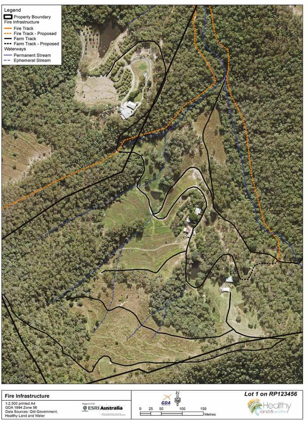
SEQ FIRE AND BIODIVERSITY CONSORTIUM

The SEQ Fire and Biodiversity Consortium – Who we are
The SEQ Fire and Biodiversity Consortium is a network of land managers and stakeholders committed to improving fire and
biodiversity management outcomes, supporting and disseminating fire ecology research, facilitating partnerships between
key stakeholders and building the capacity of land managers and private land owners in South East Queensland.
The SEQ Fire and Biodiversity Consortium gratefully acknowledges the support from the following stakeholder organisations
reflecting the broad support the organisation receives and demonstrating its active and dedicated membership: Brisbane
City Council; City of Gold Coast; Department of Transport and Main Roads (Southern Downs Region); Gympie Regional
Council; Healthy Land and Water; Ipswich City Council; Lockyer Valley Regional Council; Logan City Council; Moreton Bay
Regional Council; Powerlink; Queensland Fire and Emergency Services; Queensland Parks and Wildlife Services; Redland City
Council; Scenic Rim Regional Council; Seqwater; Somerset Regional Council; South Burnett Regional Council; Sunshine Coast
Council and Toowoomba Regional Council.
The SEQ Fire and Biodiversity Consortium gratefully acknowledges the support of Healthy Land and Water. Healthy Land and
Water is an independent, not-for-profit organisation working to improve the sustainable use of land and waterways in South
East Queensland. This project is supported by Healthy Land and Water through funding from the Australian Government’s
National Landcare Program.

       SEQ Fire and Biodiversity Consortium Consortium contact details:
       PO Box 13204 George Street, Brisbane, Queensland 4003 Ph: +61 7 3503 1415 Fax: +61 7 3177 9190

Acknowledgements:
Thanks go to the following people who have provided invaluable input and advice into Version 3 of the Manual.
Dr Samantha Lloyd (Manager, SEQ Fire and Biodiversity Consortium); the SEQ Fire and Biodiversity Consortium Education
Working Group – Maree Manby (Redland City Council), Michelle Nash (Brisbane City Council), Adrian Hansen (Ecological
Natural Area Management), Gary McCormack and Liane Henderson (QFES), Tim Killen (Queensland Parks and Wildlife
Service), Greg Leech and Bronte North (formerly of SEQ Catchments), Darren McPherson (Somerset Regional Council),
Joshua Bull (Fireland Consultancy), Sean Ryan (Private Forestry Service Queensland), Tamara Badenoch (formerly of AgForce
Queensland), Bruce Lord, Ross Bigwood, Shannon Mooney and Melissa Walker (Healthy Land and Water), Beth Welden, Annie
Keys and Dr Mark Schuster (Queensland Parks and Wildlife Service and formally of SEQ Fire and Biodiversity Consortium).

Disclaimer: This document has been prepared in consultation with a wide range of stakeholders, including the QFES. It has
been developed purely as an aid to property fire management planning and in no way acts as a guarantee for bushfire safety.
The aim of Property Fire Management Planning Kit (Planning Kit). is to minimise risk and to improve biodiversity conservation
efforts, however a degree of risk will always remain when homes and other assets are located close to vegetation. Thus,
whilst every effort has been pursued to make the information within this Manual as accurate and factual as possible, those
involved in compiling this document take no responsibility for any adverse outcomes, actions or losses resulting from
its implementation. This publication does not purport to provide legal advice, and any recommendations herein do not
necessarily represent current public policy. No person should act solely on the advice given here and should seek additional
advice as required and assume responsibility for their actions.
Further services of the SEQ Fire and Biodiversity Consortium are provided at the end of this document.
Cover photo: Fire Management Planning Workshop at Maroochy Bushland Botanic Garden
             exploring the use of prescribed fire. C. Welden.

      SEQ FIRE AND BIODIVERSITY CONSORTIUM PROPERTY FIRE MANAGEMENT PLANNING KIT PART A – USER MANUAL | 3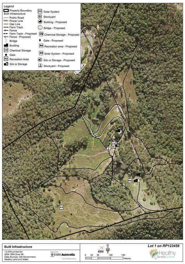
SEQ FIRE AND BIODIVERSITY CONSORTIUM

 CONTENTS

1.0   List of Acronyms			                                                                              6

2.0   Introduction			                                                                                  7
      2.1 Background to the Property Fire Management Planning Kit                                      7
		        2.1.1 	Aims			                                                                              7
		        2.1.2 Outcomes		                                                                             7
		        2.1.3 Intended use of the Property Fire Management Planning Kit                              7
		        2.1.4 Background to prescribed burning                                                       9
		        2.1.5 The science behind prescribed burning                                                  9
		        2.1.6 Assistance for prescribed burns on your property                                      10
      2.2 Why do I need a Fire Management Plan for my property?                                       11
		        2.2.1 What is my Property Fire Management Plan linked to?                                   11
		        2.2.2 Taking your Property Fire Management Plan map further                                 11
      2.3 Why make a plan?		                                                                          11
		        2.3.1 Capture and share your local knowledge                                                11
		        2.3.2 Landscape perspective                                                                 11

3.0   Before the workshop		                                                                           12
      3.1 Pre-workshop: property familiarisation                                                      12
      3.2 What you will be provided with to develop your Property Fire Management Plan                12

4.0   At the workshop – Let’s get started                                                             13
      4.1 Symbols used in the Property Fire Management Planning Kit                                   13
          4.1.1 Part A – User Manual symbols                                                          13
		        4.1.2 Mapping symbols                                                                       13
      4.2 Steps in making your Property Fire Management Plan                                          14
		        STEP 1 – Map your infrastructure                                                            14
		        STEP 2 – Map your vegetation                                                                18
		        STEP 3 – Map your fire trails/lines                                                         20
		        STEP 4 – Map your fire history                                                              24
		        STEP 5 – Map your Fire Management Zones (FMZ)                                               25
			              1.     Asset Protection Zones (APZ)                                                  25
			              2.     Strategic Fire Advantage Zones (SFAZ)                                         26
			              3.     Land Management Zones (LMZ)                                                   26
				                    a.     Conservation Zone (CZ)                                                 26
				                    b.     Special Conservation Zone (SCZ)                                        27
				                    c.     Rehabilitation Zone (RZ)                                               28
				                    d.     Sustainable Production Zone (SPZ)                                      29
			              4.     Fire Exclusion Zones (EZ)                                                     31
		        STEP 6 – Fire and biodiversity monitoring                                                   32
      4.3 Completing your Property Fire Management Action Plan                                        33

4 | SEQ FIRE AND BIODIVERSITY CONSORTIUM PROPERTY FIRE MANAGEMENT PLANNING KIT PART A – USER MANUAL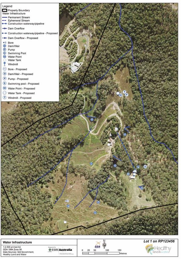
SEQ FIRE AND BIODIVERSITY CONSORTIUM

5.0   Resources				                                                                                                   33

6.0   Further services			                                                                                             36

7.0   References			                                                                                                   37

8.0   Property Infrastructure Symbology                                                                               40

                                            Gahnia spp. three weeks following fire at Coolum, Sunshine Coast. (C.Welden 2017)

      SEQ FIRE AND BIODIVERSITY CONSORTIUM PROPERTY FIRE MANAGEMENT PLANNING KIT PART A – USER MANUAL | 5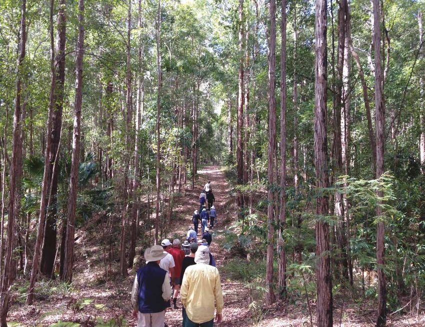
SEQ FIRE AND BIODIVERSITY CONSORTIUM

1.0 LIST OF ACRONYMS
AFAC	Australasian Fire and Emergency Service         LIDAR	Light Detection and Ranging
      Authorities Council                                    (remote sensing tool)
APZ	Asset Protection Zone                            LMZ	Land Management Zone
CFMP	Coordinated Fire Management Plan                OHFG	Overall Fuel Hazard Assessment Guide
CZ	Conservation Zone                                 RE	Regional Ecosystem
EHP	Department of Environment Heritage and           REDD	Regional Ecosystem Database Descriptions
     Protection
                                                      RFSQ 	Rural Fire Service Queensland
EZ	(Fire) Exclusion Zone
                                                      RZ	Rehabilitation Zone
FL	Habitat Feature
                                                      SCZ	Special Conservation Zone
FMZ	Fire Management Zone
                                                      SFAZ	Strategic Fire Advantage Zone
FPAA	Fire Protection Association of Australia
                                                      SPZ	Sustainable Production Zone
GIS	Geographic Information System
                                                      STAR	Smoke Taint Risk Calculator
GPS	Geographical Positioning System
                                                      PAS	Prepare Act Survive
HLW	Healthy Land & Water (SEQ based Organisation)
                                                      QFES	Queensland Fire and Emergency Services
HS	Cultural/Historical Site
                                                      QPWS    Queensland Parks and Wildlife Service
IS	Indigenous Site
                                                      SEQ	South East Queensland

                                                                   Heathland on the Sunshine Coast. (C. Welden.2016)
6 | SEQ FIRE AND BIODIVERSITY CONSORTIUM PROPERTY FIRE MANAGEMENT PLANNING KIT PART A – USER MANUAL
SEQ FIRE AND BIODIVERSITY CONSORTIUM

2.0 INTRODUCTION

2.1       Background to the Property Fire Management Planning Kit

2.1.1     Aims
The primary aim of the Property Fire Management Planning Kit (the Planning Kit) is to assist you as a landholder or land
manager to reduce the threat of bushfires/wildfires to life and assets on your property, while also protecting and enhancing
the diversity and abundance of native plants and animals on your property. The Planning Kit is intended for use at a SEQ Fire
and Biodiversity Consortium facilitated Property Fire Management Planning Workshop. On completion of the workshop you
will have developed a fire management map and action plan tailored to your property (regardless of size), priorities (such as
primary production and or conservation), and individual circumstance.

2.1.2     Outcomes
During the SEQ Fire and Biodiversity Consortium workshop, you will use the Planning Kit to develop a:
          1. Property Map (with transparency overlay),
                                                                                                      LIDAR (Light Detection
          2. Vegetation Map,                                                                          And Ranging): LIDAR is a
          3. Contour Map and/or LIDAR map (where available),                                          remote sensing tool that
                                                                                                      is used to map features
          4.	Fire Management Recording Sheets to document objectives, actions and timings            across the landscape and
              of fire management for each identified management area on the property (to              identify variation across
              help inform and direct property action plans), and                                      terrain. LIDAR can assist
                                                                                                      in identifying suitable
          5. 12 months, 2-5 years and 5+ years Property Fire Management Action Plans.                 locations for fire lines and
Collectively these maps, recording sheets and action plans will form a Property Fire                  in the identification of old
                                                                                                      farm tracks.
Management Plan that will assist you to balance fire safety, biodiversity conservation and,
where applicable, sustainable primary production on your property.

2.1.3     Intended use of the Property Fire Management Planning Kit
The Planning Kit consists of Part A – User Manual and its accompanying Part B – Workbook. An overview of these documents
and their intended use can be seen in Figure 1.
When used together at a workshop, these resources will help guide you through a step-by-step process to develop a Property
Fire Management Plan. The process itself is based on the concept that the best way to balance safety and conservation is to
manage different areas, or zones, on your property in different ways with respect to fire.
Within the Planning Kit’s Part A - User Manual, you will work through Steps 1 to 6 to progressively build up the different layers
of your property fire management planning maps giving you a comprehensive picture of the hazards on your property
and the risks these pose to assets. Information surrounding each of these steps, including the science behind underlying
principles, are outlined within this User Manual to better equip you to develop property maps and property fire management
action plans (templates found in Part B – workbook) and gain a better working knowledge of the principles and practices
behind property fire management planning.
The Part B – Workbook is intended to be used alongside the Part A – User Manual to help you document:
          i. General notes as well as information relevant to the development of property maps;
          ii.	Planning notes for any different management areas identified on your property within the Fire Management
               Recording Sheets, located in Part B Workbook;
          iii.	Property Fire Management Action Plans that can be used to implement priority tasks on your property after the
                workshop.
Note: These maps and plans are not static documents and will need regular revision to ensure currency of information over time.
	Don’t let this Planning Kit sit on the shelf once once you have competed the workbook. Regular revision is required
  to track progress and the accuracy of time frames. We suggest that you review the plan within a year of inception.

        SEQ FIRE AND BIODIVERSITY CONSORTIUM PROPERTY FIRE MANAGEMENT PLANNING KIT PART A – USER MANUAL | 7
SEQ FIRE AND BIODIVERSITY CONSORTIUM

  Figure 1. Overview of how to use Part A and Part B of the Property Fire Management Planning Kit

                                        WORKSHOP ATTENDANCE
                                   Instructor led training - face to face workshop

                                         PART A USER MANUAL                          PART B WORKBOOK
     Aerial maps provided
      during workshops                                 STEP 1
                                                                                                Notes on
                                                     Map your                                infrastructure
                                                   infrastructure

                                                      STEP 2
              Vegetation                                                                        Notes on
                                                     Map your                                  vegetation
                 Map                                vegetation

                                                        STEP 3                                 Notes on fire
              Property                             Fire trails/lines                            trails/lines
             Aerial Map
         (your transparency
              overlay)

                                                       STEP 4                                   Notes on
                                                    Fire history                               fire history

             Contour Map
                and/or
              LIDAR Map                              STEP 5                                Fire Management
            (where available)                         Fire                                 Zones - Recording
                                                   Management                               Sheet for APZs,
                                                   Zones (FMZ)                                SFAZs & EZs

                                                                                           Fire Management
                                                                                           Zones - Recording
                                                                                            Sheet for LMZs
                                                                                                including
                                                                                              CZ, SPZ & RZ

                                                       STEP 6
                                                       Fire &                                  Fire activity
                                                    biodiversity                             recording sheet
                                                    monitoring

                                                  Property Fire                      Property Fire Management
                                                Management Plan                             Action Plan

                 PROPERTY FIRE MANAGEMENT PLAN REGULAR REVIEW

8 | SEQ FIRE AND BIODIVERSITY CONSORTIUM PROPERTY FIRE MANAGEMENT PLANNING KIT PART A – USER MANUAL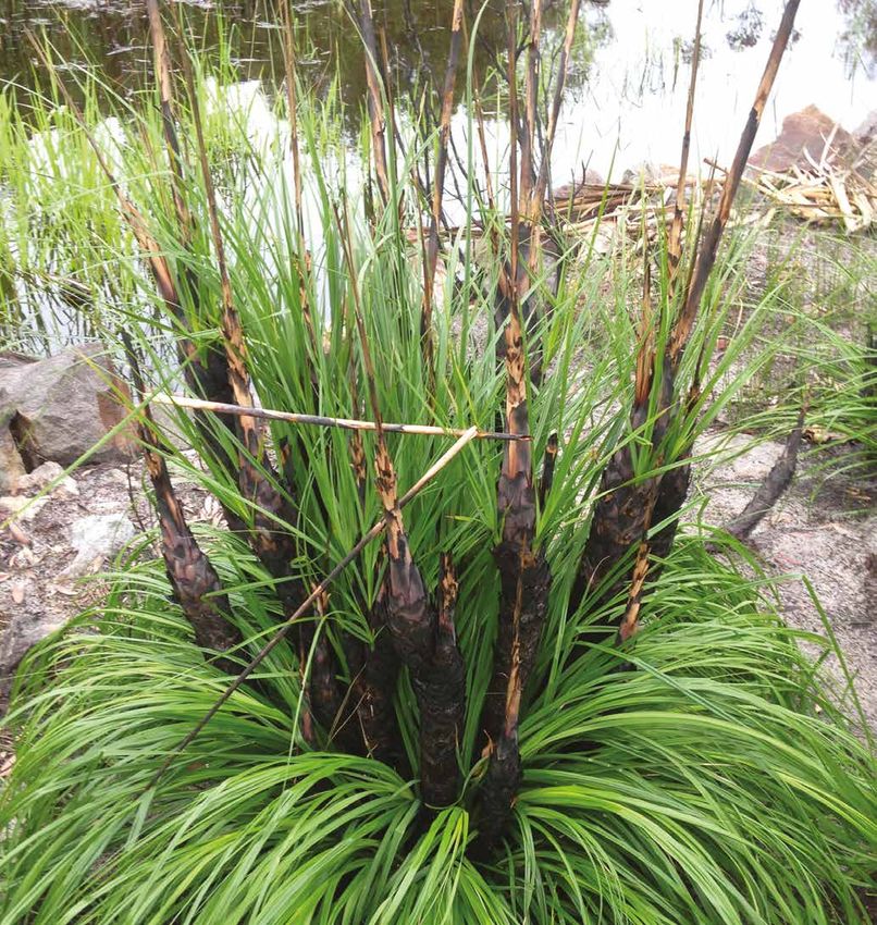
SEQ FIRE AND BIODIVERSITY CONSORTIUM

                                                                                                     Bushfires: Bushfire is a general term to
                                                                                                     describe a fire in vegetation (usually an
                                                                                                     out of control fire). We will use this term
                                                                                                     in this document as opposed to using
                                                                                                     the term “wildfire”. Definition taken
                                                                                                     directly from the Australasian Fire and
                                                                                                     Emergency Service Authorities Council
                                                                                                     - Bushfire Glossary (Rural and Land
                                                                                                     Management Group, 2010).
                                                                                                     Wildfire: A wildfire is an unplanned
                                                                                                     vegetation fire, which includes grassland
                                                                                                     fires, forest fires, heath and scrub fires.

        Christmas Bells (Blandfordia grandiflora) are an example of a fire-adapted species. This
                individual is flowing after a fire at Beerwah on the Sunshine Coast. (D Metters)

2.1.4       Fire in the Australian Landscape
Many Australian ecosystems, and the plants, animals, fungi and soils contained within them, have evolved with fire and are
adapted to particular fire regimes (Bradstock, 2008, Bradstock et al., 2012). Fire-adapted species may be damaged or killed by
fire, but have a reproductive response (e.g. the opening of banksia woody seed capsules in response to the heat of a fire or the
flowering of a grass tree).
Appropriate fire has a significant and positive role to play in maintaining the diversity of native plants, animals and fungi
species in fire-adapted communities. Positive outcomes may include:
            •	opening up the foliage canopy, allowing sunlight to reach the ground and creating an ash bed rich in nutrients for
               germinating seeds and growing plants;
            •	creating hollows in trees and logs;
            •	triggering seed release, germination and flowering; and
            •	aiding in the control and eradication of weed species, pest insects and fungal diseases.
However, there are limits to the tolerance and ability of fire-adapted plants and animals to replenish after fire. Both too
infrequent and too frequent fire can lead to species decline and even eventual local extinction. A fire regime refers to the
general pattern in which fire naturally occurs in a particular ecosystem over an extended period of time. Fire regimes are
classified by four key components: fire intensity, fire season, fire frequency (time between fires or number of fires in a given
time frame) and fire extent (patchiness or the amount of area burnt). Read more about fire regimes in the SEQ Fire and
Biodiversity Consortium Living with Fire Series-Fact Sheet 3: Recommended fire regimes (Section 6.5).
Prescribed burning is a tool that you can use as a land manager or landowner to achieve various objectives for fire safety,
biodiversity conservation, and primary production purposes. This Manual does not provide advice on the operational matters
concerning the carrying out of a prescribed burn, rather, it can give some guidance on the use of fire using appropriate fire
regimes for varying ecosystems.

2.1.5       The science behind prescribed burning
Prescribed burning is a tool that you can use as a land manager or landowner to achieve various objectives for fire safety,
biodiversity conservation and primary production purposes. This Planning Kit does not provide advice on the operational
matters concerning the carrying out of a prescribed burn, rather, it provides guidance on the use of appropriate fire in
different vegetation types (e.g. grassland and forest) and ecosystems. Prescribed fire, or planned burning has a number of
key objectives, including reducing the fire hazard (i.e. the fuel) and thereby aiding in the reduction of the risk to people and
property and aiding in providing necessary fire for ecosystems. Both too frequent and too infrequent fire can cause problems
in fire-adapted ecosystems. If fire is excluded for too long, short lived species may become locally extinct. A plant species
that only regenerates after fire may not survive if adults have died and its viable seed is no longer available (e.g. Christmas
Bells Blandfordia grandiflora). Some birds have been found to move out of areas that have not burnt for a long time as the
plants that they feed on are either shaded out or become old and die (Reside et al., 2011).

        SEQ FIRE AND BIODIVERSITY CONSORTIUM PROPERTY FIRE MANAGEMENT PLANNING KIT PART A – USER MANUAL | 9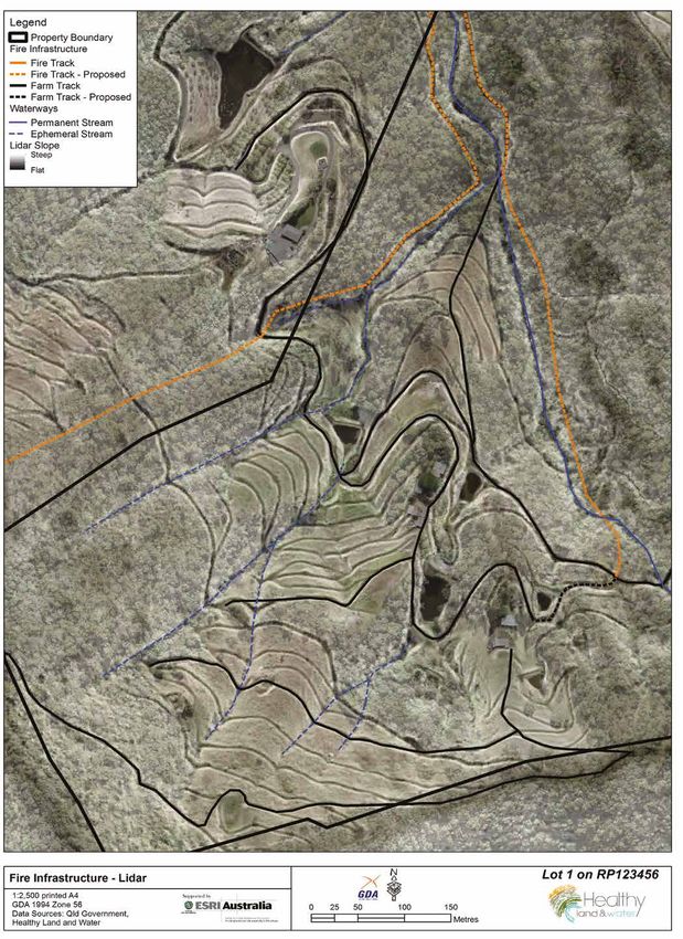
SEQ FIRE AND BIODIVERSITY CONSORTIUM

It is common for some vegetation types to be replaced by another vegetation                        Hazard and Risk
type, or even become locally extinct, as a result of the length of time since fire. An             The difference between hazard and
example of this is seen in Eucalypt forests with a grassy understory, where a shrubby              Risk is: “Hazard - is a source of potential
understory can develop over time where there is infrequent fire, to the exclusion of               harm or a situation with a potential to
a previously dominant grassy understory species. Periodic fire is needed to allow for              cause loss; whereas Risk is the chance
the persistence of the native grassy understory (Baker and Catterall, 2015).                       of something happening that will have
                                                                                                   an impact on objectives (AS/NZS ISO
Fire may affect animal populations through direct or indirect effects. Typically, the              31000:2009). It is measured in terms of
direct effects are acute and occur during, or soon after a fire, and are generally                 consequences and likelihood.”
influenced by the intensity, season (i.e. is the animal breeding) and extent of the fire.
                                                                                                   (Queensland Government, 2016)
Indirect effects are generally related to the vegetation changes post fire in terms of
the availability of refuges/homes and food.
Fire risk is influenced by nearby bushfire hazards. The rate at which fuel burns, and the intensity, is determined by several
factors including the type of vegetation (i.e. grassy woodland versus heath or open forest), the arrangement of the vegetation
(i.e. is it tightly compacted together or does it provide a vegetation “ladder” for the fire to climb), vegetation size, vegetation
and soil moisture levels, the surrounding slope, and the aspect. Fine fuels can substantially influence bushfire behaviour.
Fine fuels are those fuels that are less than 6mm in diameter if dead, and less than 3mm if alive (Hines et al., 2010).The other
major element is the weather (Cheney and Sullivan, 2008), but as we are not able to influence this factor it is not discussed at
length here except for determining prevailing winds.
1.1.6    Assistance for prescribed burns on your property
The practical application of fire in the landscape is a skilled and knowledgeable art. If you are considering a prescribed burn
for your property we encourage you get your neighbours together and seek assistance from Rural Fire Service Queensland
(RFSQ). RFSQ can provide good local knowledge and a range of skills that would be advantageous to safely carrying out a
prescribed burn. In Queensland it is illegal to light a fire without a “Permit to Light Fire” issued by a Fire Warden. See more
information on the RFSQ website www.ruralfire.qld.gov.au. There are also a number of private fire services operating in
South East Queensland who can carry out a prescribed burn on your property and assist in creating a prescribed burn plan.

                       Fine fuels shown in this image are those that burn in the continuously flaming zone at the fires edge. (C Welden 2016)
10 | SEQ FIRE AND BIODIVERSITY CONSORTIUM PROPERTY FIRE MANAGEMENT PLANNING KIT PART A – USER MANUAL
SEQ FIRE AND BIODIVERSITY CONSORTIUM
2.2 Why do I need a Fire Management Plan for my property?
Many people choose to live in areas close to remnant or regrowth vegetation in South East Queensland. Due to the increased
risk of bushfires in these areas, land owners need to make themselves aware of, and take steps to minimise, the risks to life
and property. In preparing a Property Fire Management Plan that addresses the needs of different vegetation types on your
property, you are also supporting the conservation of native vegetation and animals and potentially enhancing biodiversity.
2.2.1 What is my Property Fire Management Plan linked to?
Whilst your Property Fire Management Plan is primarily looking at the individual property scale, you will be encouraged
throughout this document to consider looking beyond your own boundary, at the landscape level (i.e. talk to your
neighbours). Fire is commonly referred to as being “tenure blind” and with most private properties in South East Queensland
being relatively small in area, most bushfires will easily travel across property boundaries, particularly in difficult terrain, and
throughout more remote locations.
Your completed individual Property Fire Management Plan can be linked with and used by:
•• A landscape fire management plan (see Section 2.3 below).
•• Fire Emergency Personnel in a bushfire: Please contact your local rural fire brigade for more information.
•• Rural Property Fire Management Guide: The RFSQ can provide a form where you can record your property for self-
assessment purposes. This guide can be downloaded from https://ruralfire.qld.gov.au/Bushfire_Planning/Documents/
Rural_Property_Fire_Management_Guide_Editable.pdf. Refer to Section 6 (Further Services).
•• The strategic aims of Healthy Land and Water: If you wish to explore more ways to look after your property and manage
it productively, please contact Healthy Land and Water by visiting their website www.hlw.org.au, or by calling the office
on +61 7 3177 9100, or contact the SEQ Fire and Biodiversity Consortium.
2.2.2 Taking your Property Fire Management Fire Plan map further Your role in Rural Fire
Service Queensland
Depending on the complexity and extent of your property and available resources, it may
be possible to digitise your map, so it may be viewed and edited either as a KML file in RFSQ is always seeking active
Goggle Pro/Earth, or as a PDF, you can contact the Healthy Land and Water GIS Team by volunteers for local Rural Fire
visiting www.hlw.org.au/services/gis-mapping, www.lfwseq.org.au/maps, or contact the Brigades. There are many
SEQ Fire and Biodiversity Consortium for more information. roles that you can perform
from firefighting, community
2.3 Why make a plan? education, fundraising and
administration.
2.3.1 Capture and share your local knowledge
Even if you, or your family, have been on your property for generations and have used fire as a management tool, your
knowledge of local fire history, such as the frequency of burns in different management zones and the impact on vegetation
and wildlife, may be lost if you do not capture it. This information is valuable for neighbours and future generations, to help
improve the usefulness of fire regimes and fire management planning in your local area. This information will also help in
understanding the relationship between weather patterns and fire.
2.3.2 Landscape perspective
It is important that through the process of making your Property Fire Management Plan, you consider all actions taken
and planned, and include what your neighbours may, or may not, be considering. Fire is “tenure blind” and may not stop
immediately at fire lines, fire tracks, fence lines or property boundaries. It is therefore important to consider where your fire
lines may be constructed and what hazards are on your property that may pose a risk to neighbouring assets. This will most
often mean talking to your neighbours and working together to create a landscape fire management plan.
SEQ FIRE AND BIODIVERSITY CONSORTIUM PROPERTY FIRE MANAGEMENT PLANNING KIT PART A – USER MANUAL | 11SEQ FIRE AND BIODIVERSITY CONSORTIUM
3.0 BEFORE THE WORKSHOP
3.1 Pre-workshop: property familiarisation
Each workshop is one day in duration, and covers a lot of content to help guide you, (the landholder or land manager),
through a comprehensive Fire Management Plan for your property. Therefore we ask that before you attend, you familiarise
yourself with the key features and infrastructure located on your property. That is, you may want to walk/drive/ride around
your property and look for the features outlined in the Steps 1-6 in this User Manual. You will also be required to map your
neighbour’s property assets (tenure blind approach). If you wish, you can map some of the features using a GPS or use a
mobile application that can download maps and record activity and save this information as a pdf for reference during the
workshop. As your plan will affect everyone who lives on your property, consider including the whole family in the planning
process.
Bring any maps or plans you already have relevant to your property to the workshop (i.e. property management plans,
vegetation maps, aerial photos).
3.2 What you will be provided with to develop your Property Fire Management Plan
All participants will be supplied with the following at the workshop:
1. Property Fire Management Planning Kit: Part A – User Manual (this booklet) and Part B – Workbook:
2. Maps that show the following features of your property (printed to an A3 size to match the transparency overlay):
a.
Aerial photo - (this will become your base map);
b.
Topography - contour lines;
c.
Regional Ecosystems (Description of Regional Ecosystems is found on page 17); and
d.
LIDAR (if available).
3. Clear A3 transparency (overlay);
4. Mapping accessories:
a.
Set of 8 fine point coloured permanent marking pens;
b.
Ruler;
c.
Eraser;
d.
Methylated spirits and a cloth or a white board marker (to fix mistakes on transparency);
e.
four small, fold back clips.
Many agencies (such as Queensland Parks and Wildlife Service staff pictured) contribute in the lead up to, on the
day and post workshop helping communities become bushfire resilient. (C.Welden 2017)
12 | SEQ FIRE AND BIODIVERSITY CONSORTIUM PROPERTY FIRE MANAGEMENT PLANNING KIT PART A – USER MANUALSEQ FIRE AND BIODIVERSITY CONSORTIUM
4.0 AT THE WORKSHOP - LET’S GET STARTED
You will be provided with an aerial map of your property detailing contours and features of your property. At the workshop
you will work on additional worksheets and maps and progressively build up the layers giving you a comprehensive picture
of the hazards on your property and the risks these pose to assets.
To assist you in recording information during the workshop more easily, the Property Fire Management Planning Kit: Part
B - Workbook, is a separate booklet. The Workbook is also available to be downloaded in an editable format by visiting www.
fireandbiodiversity.org.au. If you have used up all the space on your worksheets you can also print off extra copies from the
website. Please open your Part B – Workbook to the Fire Management Recording Sheets.
TIP: Within your Workbook, we have included sections on infrastructure, vegetation, fire trails and fire history. You
may find that you need to write down some notes during the workshop that you can refer to later. Remember, that
long past the workshop, notes may assist you in reviewing and implementing your Property Fire Management Plan.
Remember, as we have already discussed, recording information about planned burns or bushfires is useful for future planning
needs. An example of this can be an understanding of fuel behaviour in a certain vegetation type, or plant responses due to
intensity. Some examples are provided below the maps in each of the mapping steps.
It is recommended that if you plan to sell your property that you pass on this Property Fire Management Plan to the new
owners.
4.1 Symbols used in the Property Management Planning Kit
The standard symbols (also known as elements) used within this User Manual are consistent with those used in both QFES
operations mapping and the HLW property planning process.
4.1.1 Part A – User Manual symbols
You will notice that we have provided symbols beside each action to help make the mapping process easier, as follows:
Action – this hoe/rake symbol will prompt you to add information in the action sheets in the Workbook. The symbol
is a rake hoe, also known as a McLeod tool (available at most hardware stores). Rake hoes are useful for creating
temporary small fire lines for a prescribed burn.
Mapping – when you see this symbol you will be required to map the features that are mentioned within the
workshop on the transparency that is provided.
Tip – handy hints for completing your tasks.
4.1.2 Mapping symbols
You will find the Property Infrastructure Symbology on the back page of this User Manual Section 8. Remove this page to
make it easier to use as a reference for your mapping.
Unburnt areas, as shown in this image, provide important refuges for animals during fire and a base from which
they can recolonise following fire (SEQFBC 2014 Recommended Fire Regimes). (C. Welden 2017)
SEQ FIRE AND BIODIVERSITY CONSORTIUM PROPERTY FIRE MANAGEMENT PLANNING KIT PART A – USER MANUAL | 13SEQ FIRE AND BIODIVERSITY CONSORTIUM
4.2 Steps in making your Property Fire Management Plan
Step 1 – Map your infrastructure
To produce a fire management map for your property, first you need to have a clear picture of what the current built assets
are on your property (refer to Section 8: Property Infrastructure Symbology), where they are located, and their proximity to
hazards.
1. Place your transparency over your map.
2. Mark in the corners of the map with a cross, as seen in Figure 2 below, so this can be used as a reference point.
TIP: Use the four small fold back clips at each edge of the map to secure the transparency in place.
Figure 2. Mark the corners of your map with a cross on the transparency so that
you can refer to this spot each time you change maps.
To make referencing easier, use the following eight colours for drawing the various elements of your map:
Black, green, yellow, brown, purple, blue, red and orange.
Don’t worry if you use a different colour scheme to that recommended throughout the User Manual, but keep yours
consistent throughout the labelling process, and draw a key to reference the colours accordingly.
Basic Information required (Black):
•• Property name (if applicable)/address/lot on plan;
•• Scale;
•• Property boundary;
•• Direction of prevailing winds;
•• North arrow;
•• Date of drawing; and
•• Proposed revision date (suggest 1 to 2 years).
Built Infrastructure (existing) (Black):
•• Houses, outbuildings, sheds and other buildings;
•• Roads and internal property tracks, noting how accessible they are to vehicles;
•• Fences (both proposed and existing) and gates;
•• Power lines – those going to your house and large utility lines. If it is a large utility line, this area will be zoned
differently. More details to assist you are supplied in Step 5 - Fire Management Zones;
•• Gas pipelines;
•• Hazardous chemicals and/or substances (include old stock dip sites here too);
•• Recreational structures (e.g. tennis court);
•• Fire tracks/lines; and
•• Include proposed infrastructure such as buildings, fire trails, fences roads etc. Use a dotted line and mark
proposed; and
Remember to map your neighbour’s property assets (tenure blind approach).
14 | SEQ FIRE AND BIODIVERSITY CONSORTIUM PROPERTY FIRE MANAGEMENT PLANNING KIT PART A – USER MANUALSEQ FIRE AND BIODIVERSITY CONSORTIUM
Map 1. Worked example of adding the built infrastructure to your map.
SEQ FIRE AND BIODIVERSITY CONSORTIUM PROPERTY FIRE MANAGEMENT PLANNING KIT PART A – USER MANUAL | 15SEQ FIRE AND BIODIVERSITY CONSORTIUM
Water infrastructure (Blue)
•• Permanent rivers/creeks/streams;
•• Intermittent (temporary) rivers/creeks/streams;
•• Constructed waterways/pipelines;
•• Water tanks;
•• Dams, weirs and bores (please show overflow for the dams – i.e. boggy patches where a fire vehicle could
get stuck);
•• Stock watering points (off stream troughs);
•• Windmills;
•• Pumps and associated sheds/covers; and
•• Swimming pools.
Use a dotted line to indicate proposed water infrastructure, and mark “proposed”.
In your Fire Management recording sheets (see Page 5 Part B - workbook), please record detailed information on the above
water infrastructure, such as the capacity of water tanks and if pumps are electric or internal combustion.
Culturally significant sites (Purple)
•• Mark on your transparency scar or carved trees, rock shelters that may house Traditional Owner artwork, or
early European infrastructure. Mark with purple circles and mark HS and/or IS (abbreviation of Historical and
Indigenous Site).
•• If your map is to be shared, be aware that some sites may be culturally sensitive and therefore it may be
necessary to exclude them from your maps.
•• Also consider marking any culturally significant sites on your property with a permanent in-ground marker
(such as a star picket) to avoid it being damaged during reactive firefighting operations (State of Victoria,
2015).
Remember, if you identify what appears to be a culturally significant site, immediately stop doing anything that may harm
or interfere with the artefact or site and contact the Department of Aboriginal and Torres Strait Islander Partnerships.
Preservation of our cultural heritage is important to preserve for future generations, plays an important part of indigenous
culture today and has scientific and aesthetic values.
For further advice and information surrounding culturally significant sites, please refer to 5.4 Cultural Heritage within the
Resources Section and 6.4 of the Further Resources Section located at the end of this User Manual.
Refer to Map 3 for a worked example of a map identifying and highlighting culturally significant sites.
Important habitat features (Purple)
This might include old trees with hollows, logs and rocks used by animals for shelter or nests, or the location of rare or
threatened species. Mark with purple circles and mark FL (e.g. ignificant flora or habitat features).
Refer to Map 3 for a worked example of a map identifying and highlighting important habitat features.
Neighbouring property bushland and assets
Label, identify and map nearby bushland
and assets on neighbouring properties. Use
the colours and symbols as above.
The RFSQ displays recent fire danger ratings for
regions across Queensland sourced from advice
from the Bureau of Meteorology. To understand
how the fire danger ratings are determined visit:
http://www.bom.gov.au/weather-services/
bushfire/index.shtml (C. Welden. 2016)
16 | SEQ FIRE AND BIODIVERSITY CONSORTIUM PROPERTY FIRE MANAGEMENT PLANNING KIT PART A – USER MANUALSEQ FIRE AND BIODIVERSITY CONSORTIUM
Map 2. Worked example of adding water infrastructure and waterways to your map.
SEQ FIRE AND BIODIVERSITY CONSORTIUM PROPERTY FIRE MANAGEMENT PLANNING KIT PART A – USER MANUAL | 17SEQ FIRE AND BIODIVERSITY CONSORTIUM
Sample notes – please add notes in your Workbook (Part B).
Example – Fire Management Recording Sheets - Notes on Infrastructure
Basic infrastructure, water, built environment, culturally significant sites, or important habitat features.
Dam has overflow and is wet for most of the year – larger vehicles will get bogged.
Scar tree on western side near dam. Need to mark this down in the actions to ensure it is
kept free of leaves at its base so it doesn’t burn down.
Consider a cultural heritage plan.
Fuel load is too high near pump shed – need to include in actions to reduce fuel load
around the pump.
Step 2 – Map your vegetation Regional Ecosystem (RE): A regional
ecosystem (RE) is a vegetation
How to map your vegetation community classification system used
During the workshop, you will be given a copy of the regional ecosystem within Queensland, developed by the
(RE) mapping for your property. Use this map as a guide to map your REs. In Queensland Herbarium. Vegetation
communities are associated with a
many cases the mapping may not be accurate, at the smaller scale we are
combination of bioregion geology,
looking at, therefore you will need to check on your aerial map that the RE
landform and soil. Please refer to
boundary is accurate. the Regional Ecosystem’s Database
For land managers and landowners who have more than one RE on their Descriptions for the RE that is within
property, please mark on the map the RE number (i.e. 12:3:5) so that you can each conservation zone. https://
w w w. q l d. g ov. a u / e nv i ro n m e nt /
refer to it in the Fire Management Zone steps.
plants-animals/ plants/ecosystems/
Within each of the RE’s there may be other types of vegetation that are download. For more information
not covered by the RE mapping, such as riparian/creek line vegetation. on REs, refer to the following Land
Be aware that for some vegetation types, fire should be excluded due to For Wildlife Regional Ecosystems
fact sheet - www.lfwseq.org.au/
that vegetation type being sensitive to fire. Examples include riparian areas
wp-content/uploads/2016/11/LFW-
(vegetation around creeks and rivers) and dry vine scrub. Keep a record
Note-2016_V1.pdf
of this in your Workbook: Fire Management Recording Sheets – Notes on
vegetation. You will make changes to your vegetation map to reflect this in
Step 5.3 Land Management Zones (LMZ) and Step 5.4 Fire Exclusion Zones
(EZ).
Sample notes – please add notes in your Workbook (Part B).
Example – Fire Management Recording Sheets - Notes on Vegetation
The boundaries for most of the RE’s in the mapping provided in the workshop appear to be
correct. Need to double check the accuracy of the creek line (riparian) vegetation
Need to look at exclusion of fire on this riparian vegetation and start some weed
management of the non-native grasses that are growing under the riparian vegetation
18 | SEQ FIRE AND BIODIVERSITY CONSORTIUM PROPERTY FIRE MANAGEMENT PLANNING KIT PART A – USER MANUALSEQ FIRE AND BIODIVERSITY CONSORTIUM
Map 3. Worked example of adding culturally significant sites, vegetation community types and habitat features to your map.
SEQ FIRE AND BIODIVERSITY CONSORTIUM PROPERTY FIRE MANAGEMENT PLANNING KIT PART A – USER MANUAL | 19SEQ FIRE AND BIODIVERSITY CONSORTIUM
S
tep 3 – Map your fire trails/lines (Orange)
The purpose of fire trails are for providing access for firefighters to
respond quickly to a bushfire. Therefore fire trails are very useful across
the landscape provided they are maintained well and accessible for fire
fighting vehicles.
Map current fire trails in orange and any proposed trails with a dotted
line in orange.
Investigate if there are any old trails on your property that can be repaired
and used again.
Tip: Before you plan to carry out any clearing of native vegetation
Example of a permanent fire trail.
be sure to check local, state and federal legislation. To find out Notice the side drain on the left that is taking water
more please visit: https://www.qld.gov.au/environment/land/ from the whoo boy. (C. Welden, 2010)
vegetation/clearing (accessed online 24 July 2017)
Tip: Remote mapping, using LIDAR, can assist in determining old Fireline: A fireline is a natural non flammable
trails that you may not be aware of. area, providing a containment edge for fire
suppression for prescribed burning. This may
Tip: If you are considering construction of permanent fire trails, include rainforest, mangrove, creeks, water-
you will need to think carefully about drainage. Construction of bodies, rock (P, Leeson, QPWS, pers.comm.,
fire trails is all about drainage, drainage, drainage. If the track is 2017).
not properly constructed, erosion is likely to occur that can very
quickly make your track impassable and will be a waste of time, money, as well as potentially erosion into local creeks
and tributaries (Queensland Murray Darling Committee, 2012). Take care when constructing trails on soils that are
highly erodible, such as in metamorphic hills. Keep in mind that any drainage channels require some fall in order for
them to be self-cleaning (D. Kington, QPWS, pers. comm 2017). To learn more about soils and their erodibility, you can
seek information from your local HLW Area Manager or the website.
Permanent versus temporary fire trails
You need to determine whether you require a permanent fire trail, or if a temporary track is sufficient. The construction of a
permanent fire trail usually requires disruption of the soil profile and the vegetation community that may introduce weed
species and can lead to soil erosion if not properly constructed. Additionally, a permanent fire trail can be used as a carriage
way for pest animals and also facilitates the fragmentation of vegetation communities, and if they are too wide, can disrupt
fauna movements.
Temporary fire trails can be used when carrying out a prescribed burn, and these trails can be slashed and/ or brush-cut. The
general rule of thumb for the width of a fire trail for prescribed burns is twice the expected flame height, and for bushfires
this increases to five times the expected flame height (Marsden-Smedley and Sherriff, 2013).
For slashed trails, the soil and associated slashed vegetation must be sufficiently moist if using the trail for prescribed burn
purposes, otherwise the trail must be patrolled on a regular basis during the prescribed burn period.
Natural barriers that can be used for prescribed burns include creeks, dams, rainforest patches and gullies as they generally
negate the need for a permanent fire trail (McGuffog. T, undated). Care must be taken however, to avoid fires burning into
these fire sensitive communities by ensuring there is sufficient soil moisture and that burning occurs from the edge outwards
from these areas.
Tip: Remember that topography may dictate that a fire line may be best placed on, or through, your neighbour’s
property.
Tip: If vehicles cannot pass easily on the sides of the trail (due to slope and or dense vegetation) it is recommended
that you include passing bays. Many government construction guidelines recommend passing bays at 200 metre
intervals. To allow for most long fire fighting vehicles they should be a minimum of 20 metres long and 6 metres wide
(Leask, J. and Smith, 2011). Maintain minimum vegetation clearance height of 4 metres. This includes the track/road
into your property.
20 | SEQ FIRE AND BIODIVERSITY CONSORTIUM PROPERTY FIRE MANAGEMENT PLANNING KIT PART A – USER MANUALSEQ FIRE AND BIODIVERSITY CONSORTIUM
Key points:
a. Limit the number of fire trails to the number you can maintain, as every track increases bushland fragmentation,
promotes opportunities for weeds and feral animals, adds to property maintenance costs and increases the potential
for erosion;
b. Use established tracks on your property as much as possible;
c. Consider tracks on, or through, your neighbour’s property;
d. When constructing a trail, the main consideration is drainage, therefore avoid steep gradients. Use construction methods
that slow and remove surface water so that erosion does not occur;
e. Consider slashed fire lines when carrying out a prescribed burn;
f. Allow space for a fire vehicle to turn around (including a farm ute with fire trailer) and clear vegetation to a height of 4
metres;
g. Any gates should be a minimum of 3.6 metres wide;
h. Avoid no through roads. If no alternative is available, they must be well sign posted at the start of the track to indicate
that there is no through access. At the end of the road there must be area for a fire vehicle to turn around.
Tip: It is a good idea to inform your local Rural Fire Brigade (RFB) of any new fire infrastructure such as fire tails that
you have added to your property. Taking your local RFB on a familiarity tour of any new trails will assist them in the
event of a bushfire.
For further information on the construction of fire trails including drainage, turn around zones, passing bays for fire trucks
etc., please refer to Section 5.7 Resources at the back of this User Manual.
Action: List any actions in the 12 months, 2-4 years and 5+ years tables in your Workbook (Part B) on pages 19-22.
Worked example for Part B – Workbook: Fire Management Recording Sheets - Notes on Fire Trails
Need to chat to Fred (neighbour) about placing fire trail on our boundary – future fire trail.
Need to budget for a fire trail on the western side near Mary and George’s (neighbour) boundary.
Speak to the Rural Fire Brigade about passing on GPS maps of our current fire trails.
Need to be careful with fire trails on the highly erodible sites – where the soils are overlying
weathering rock.
Course aggregate like that shown in this image will assist in a boggy/wet situation. This trail allowed fire fighters to control the 2017
Caloundra Wildfire. (C. Welden. 2017)
SEQ FIRE AND BIODIVERSITY CONSORTIUM PROPERTY FIRE MANAGEMENT PLANNING KIT PART A – USER MANUAL | 21SEQ FIRE AND BIODIVERSITY CONSORTIUM Map 4. Worked example of adding fire trails and waterways to your map. 22 | SEQ FIRE AND BIODIVERSITY CONSORTIUM PROPERTY FIRE MANAGEMENT PLANNING KIT PART A – USER MANUAL
SEQ FIRE AND BIODIVERSITY CONSORTIUM

Map 5. Worked example of the use of LIDAR mapping. Note the old tracks and streams that are now visible with the use of
LIDAR technology, that are not visible in the aerial maps within this User Manual

    SEQ FIRE AND BIODIVERSITY CONSORTIUM PROPERTY FIRE MANAGEMENT PLANNING KIT PART A – USER MANUAL | 23
SEQ FIRE AND BIODIVERSITY CONSORTIUM
Step 4 – Map your fire history (Red)
Recording the fire history of your property is an important step in determining future fire regimes and protecting your
property assets. The direction, intensity and type of fire are all important factors to consider when recording your fire history,
or when asking someone about the fire history of your property.
You can use remote mapping tools such as the Queensland Government’s fire scar mapping that has been mapped from
1986 to present. It is worth remembering that these are only tools, and there are some limitations to their use. To access
these fire scar maps please go to: www.qld.gov.au/environment/land/vegetation/mapping/firescar.
If you don’t know the fire history of your property, or you are having trouble recalling this information, you may want to speak
to people that have been in the area for a long time, your local RFSQ volunteers, or if you live within a peri urban area, speak
to your local urban fire fighters.
Tip: There are some observable clues to look for on your property that can help to determine fire history, including:
•• grass-tree skirts where grass trees are present. See for examples Figures 4 and 5 below;
•• the age classes of the vegetation. The QPWS publication, “Planned Burn Guidelines” provides a pictorial guide
and indicators to look for within vegetation groups, where fire has been excluded for some time. (Refer to:
www.nprsr.qld.gov.au/managing/planned-burn-guidelines.html);
•• checking to see if the fire history mapping, or what you have learnt from oral history, is the same as the
observations you have made;
•• presence and age of charred bark on rough barked trees such as bloodwood (P. Leeson , QPWS pers.comm.
2017).
Long unburnt (20 years plus) “skirt” on a grass tree. Grass Tree with the skirt having one year’s growth following the
(P. Leeson. QPWS year unknown) Stradbroke Island Bushfire of 2013. (Watson. 2014)
24 | SEQ FIRE AND BIODIVERSITY CONSORTIUM PROPERTY FIRE MANAGEMENT PLANNING KIT PART A – USER MANUALSEQ FIRE AND BIODIVERSITY CONSORTIUM
Action: List in your Workbook: Fire Management Recording Sheets – Notes on fire history some of the following key
points, for your own future reference.
•• Direction of fire and boundary of fire.
•• Year, and if possible, the exact date of the fire (e.g. could be used for exact weather referencing).
•• The intensity of the fire. The Queensland Government’s “Planned Burn Guidelines - How to asses if your burn
is ready to go” can be used to assess fire severity post fire. Tables are provided for differing vegetation types.
Refer to: https://www.npsr.qld.gov.au/managing/pdf/pbg-assess-a5.pdf
Worked Example of Part B – Workbook: Fire Management Recording Sheets - Notes on fire history
Date of Fire Map coordinates of ignition Bushfire or planned burn? Fire intensity?
See QPWS planned burn manual for
guidance for fire intensity
20 May 2002 27*.46870 LAT Planned burn It was a low intensity fire. Got a
bit hot in some molasses grass.
153*02515Long
Feb 2008 Same as above Bushfire Came across from the west from
Nel and Freds place. Was pulled
up at Browns Roads.
Step 5 – Map your Fire Management Zones (FMZ) (Yellow)
Now that you know a little more about the vegetation and assets on your property, we would like you to break up the
property into Fire Management Zones (FMZ) according to land use and associated risk.
We have used the following FMZ’s. These are consistent with most government land management agencies across South
East Queensland, and as suggested by the Council of Australian Governments (COAG), cited in the report for the National
Burning Project March 2015 (AFAC, 2015):
1. Asset Protection Zones (APZ)
2. Strategic Fire Advantage Zones (SFAZ)
3. Land Management Zones (LMZ)
4. Fire Exclusion Zones (EZ)
This Fire Management Plan focuses on land management and exclusion zones. For building protection measures, please
refer to the “Prepare Act Survive” material prepared by the Queensland Fire and Emergency Services as outlined in Section 6:
Further Services.
1. Asset Protection Zones (APZ)
An Asset Protection Zone (APZ) is an area surrounding a dwelling/structure
that can be defended from bushfire. There are also recommendations from Asset Protection Zones (APZ) are intended
State Planning Policy and local government local laws that need to be to be safe zones for firefighters and home
considered, particularly when you are planning a new dwelling or making owners (home owners that are prepared
changes to your existing dwelling. Additionally, you need to consider laws and capable) to use to defend a property
when removing vegetation. during a bushfire event. Recent research
suggests reducing any vegetation in the
An effective way to minimise bushfire risk is to think carefully about how you
APZ from 90% to 5% will significantly
design your house and other assets, and where you place them. Ridge top
reduce potential house loss (Gibbons et
sites and steep slopes, particularly west-facing slopes, are best avoided. The
al., 2012).
best designs are simple ones that minimise corners where burning embers
could get trapped. Spaces under the house and eaves where embers may get
in should be bricked up or screened.
SEQ FIRE AND BIODIVERSITY CONSORTIUM PROPERTY FIRE MANAGEMENT PLANNING KIT PART A – USER MANUAL | 25SEQ FIRE AND BIODIVERSITY CONSORTIUM
Tip: The Victorian Government’s “Guide to retrofit your home for better protection from a bushfire” is a great start to
consider changes to better protect your assets: http://www.cfa.vic.gov.au/fm_files/attachments/plan_and_prepare/
bushfire_home_retrofit.pdf.
You may also want to consider contacting a bushfire planning and design consultant, who are registered as meeting specific
accreditation and competency requirements. See Section 6.3: Fire Protection Association Australia at the back of this User
Manual to find a provider.
Recognise that different vegetation types (under the same conditions) burn differently, with differing intensity and ember
potential. You can manipulate the hazard, and thereby reduce the risk, by burning or mechanical treatment (i.e. slashing/
mowing).
Mark these areas on your map as APZ 1, APZ 2 and so on.
Action: You will need to identify within your Asset Protection
Zones (APZ) your actions, objectives and the timing of when
you are planning to carry out your actions and record this
within your Workbook: Fire Management Recording Sheet –
Asset Protection Zones.
While the most common mechanism for house loss is from ember attack, this house is at risk of direct flame contact. Also
note the lineal fuel connectivity allowing a fire to easily travel from the surface ground fuels to mid fuels. (C. Welden, 2002)
2. Strategic Fire Advantage Zones (SFAZs)
A Strategic Fire Advantage Zone (SFAZ) is usually situated between the hazard and the APZ and is an area intended to reduce
the bushfire hazard, slow a fire down and reduce its intensity. These are areas where prescribed burning is the most effective
risk reduction management tool. Your SFAZ may have natural barriers, such as creek lines that may assist in slowing the fire.
Mark these areas on your map as SFAZ 1, SFAZ 2 and so on.
ction: You will need to identify within your Strategic Fire Advantage Zones (SFAZs) your actions, objectives and
A
when you are planning to carry out your actions and record this within your Part B: Workbook - Fire Management
Recording Sheet: Strategic Fire Advantage Zones.
3. Land Management Zone (LMZ)
Land Management Zones (LMZ) are areas that are managed for conservation, production, and cultural purposes.
We can break these up into further sub-zones (each is explained more fully below):
a. Conservation Zone (CZ)
b. Special Conservation Zone (SCZ)
c. Rehabilitation Zone (RZ)
d. Sustainable Production Zone (SPZ)
a) Conservation Zone (CZ)
These are areas that you have set aside for the protection and conservation of vegetation types and associated fauna
communities.
You will have already mapped your Regional Ecosystems (RE) on your property. If you have more than one RE, it is important
to map it differently from others as they will most likely have different fire regime characteristics.
Mark these as CZ 1, CZ 2 and so on.
Action: You will need to outline within your Conservation Zone (CZ) your actions, objectives and the timing of your
actions and record this within your Workbook: Fire Management Recording Sheet – Land Management Zones (a
worked example is provided below). Please refer to the Regional Ecosystem’s Database Descriptions (REDD) for the
RE that is within each conservation zone. For more information please refer description of REs under Step 2 of this
manual. https://www.qld.gov.au/environment/plants-animals/plants/ecosystems/download.
26 | SEQ FIRE AND BIODIVERSITY CONSORTIUM PROPERTY FIRE MANAGEMENT PLANNING KIT PART A – USER MANUALYou can also read