West Coast Fire Management Area Fire Protection Plan 2018
←
→
Page content transcription
If your browser does not render page correctly, please read the page content below
West Coast Fire Management Area
                        Fire Protection Plan
                                       2018

West Coast Fire Protection Plan 2018           1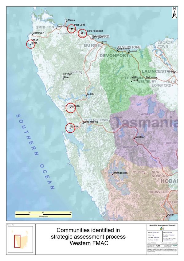
Document Control
Document History
Version                  Date            Author        Section

1.0                      December 2017   C Heyworth    FRU

West Coast Fire Management Area Committee Members
Agency                       Name
Circular Head Council        Julie Bernhagen (Chair)
Burnie City Council          Michael Foster
Forico                       Adam Crook
TasNetworks                  David Inglis
West Coast Council           Dirk Dowling
TasNetworks                  Michael Philpot
Waratah-Wynyard Council      Paul Smith
Tasmania Fire Service        Shane Batt
Tasmania Fire Service        Robert Dawes
Hydro Tasmania               Tony Harris
TasWater                     Louise Maconachie
State Emergency Service      Wayne Richards
Circular Head Council        Julie Bernhagen (Chair)
Tas Parks & Wildlife Service Eddie Staier
Sustainable Timber Tasmania  Peter Rowlands
Waratah-Wynyard Council      Bill Walker
Cradle Coast NRM             Grant Pearce
Crown Lands Services         Jenny Cook

Document Endorsement
Endorsed by West Coast FMAC Chair – Julie Bernhagen

Accepted by State Fire Management Council

SFMC Chair – Ian Sauer
Date: 30 April 2018

West Coast Fire Protection Plan 2018                             2
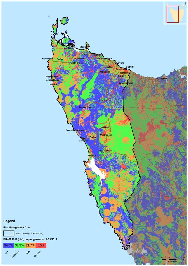
Table of Contents
Document Control ................................................................................................................................ 2
      Document History ......................................................................................................................... 2
      West Coast Fire Management Area Committee Members .................................................... 2
      Document Endorsement .............................................................................................................. 2
Glossary             5
Acronyms             7
Chapter 1            Introduction .................................................................................................................... 8
      1.1        Background ....................................................................................................................... 8
      1.2        Aim and Objectives .......................................................................................................... 8
      1.3        Context ............................................................................................................................... 9
      1.4        Tenure-blind fire management approach ................................................................... 10
      1.5        Policy, Standards and Legislation................................................................................ 11
Chapter 2            Establishing the Context............................................................................................ 12
      2.1        Description of the West Coast Fire Protection Plan Area ........................................ 12
       2.1.1          Location and Boundaries ......................................................................................... 12
       2.1.2          Land Tenure ............................................................................................................... 14
       2.1.3          Climate and Bushfire Season .................................................................................. 16
       2.1.4          Vegetation .................................................................................................................. 19
       2.1.5          Population and Demographics ................................................................................ 21
       2.1.6          Bushfire Frequency and Causes of Ignition .......................................................... 22
Chapter 3            Analysing and Evaluating Bushfire Risk ................................................................. 24
      3.1        Analysing Bushfire Risk ................................................................................................. 24
      3.2        Likelihood......................................................................................................................... 24
      3.3        Consequence (values at risk) ....................................................................................... 25
      3.4        Overall Risk ..................................................................................................................... 26
      3.5        Risk Analysis for the West Coast Fire Management Area ....................................... 26
      3.7        Community Risk Assessment ....................................................................................... 29
      3.8         Areas of strategic importance within the West Coast FMA .................................... 33
      3.9          Strategic fuel management ......................................................................................... 35
Chapter 4            Bushfire Risk Treatment ............................................................................................ 37
      4.1        Region Wide Controls .................................................................................................... 37
      4.2        Asset Specific Treatment Strategies ........................................................................... 37
      4.3         Treatment Options - Planned burning ........................................................................ 38
      4.5         Bushfire Risk Mitigation programs – other agencies ............................................... 39

West Coast Fire Protection Plan 2018                                                                                                                  3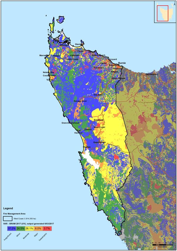
4.6        Treatment Program for priority communities and strategic areas.......................... 42
    4.7       Annual Implementation Program ................................................................................. 42
    4.8       Implementation ............................................................................................................... 42
Chapter 5         Monitoring and Review .............................................................................................. 43
    5.1       Review ............................................................................................................................. 43
    5.2       Monitoring ........................................................................................................................ 43
    5.3       Reporting ......................................................................................................................... 43
Appendices 45
    Appendix 1 – Map of West Coast Fire Management Area boundary ................................. 46
    Appendix 2 – Land tenure map and table ............................................................................... 47
    Appendix 3 – Vegetation Map and TasVeg community descriptions ................................. 49
    Appendix 4 – West Coast Fire Management Area population distribution map ............... 53
    Appendix 5 – Fire Frequency, History and Ignition Causes maps ...................................... 54
    Appendix 6 – BRAM (Bushfire Risk Assessment Model) explanation ............................... 57
    Appendix 7 – NERAG risk assessment approach ................................................................. 63
    Appendix 8 – BRAM Risk Assessment Maps – Likelihood, Consequence, Risk ............. 67
    Appendix 9 – Phoenix ignition points map.............................................................................. 70
    Appendix 10 – TFS Community Fire Safety Division Programs and Plans ....................... 71
    Appendix 11 - Treatable/untreatable areas maps and tables .............................................. 73
    Appendix 12 – List of fire management related documents for the West Coast Fire
    Management Area ...................................................................................................................... 76
    Appendix 13 – Annual Implementation Program – West Coast FMA 2016/17 ................. 79

West Coast Fire Protection Plan 2018                                                                                                             4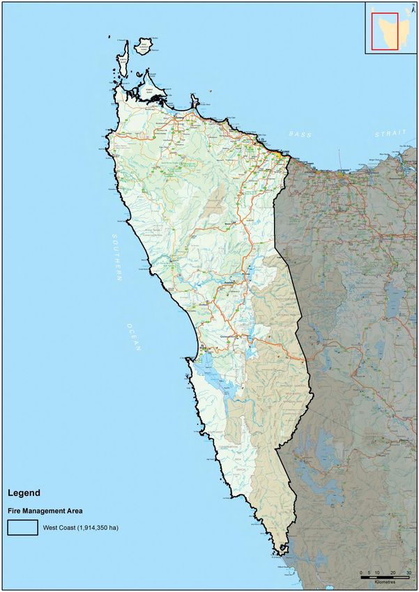
Glossary
Asset                    A term used to describe anything valued by the community that
                         may be adversely impacted by bushfire. This may include
                         residential  houses,     infrastructure, agriculture, industry,
                         environmental and heritage sites.
Asset Zone               The geographic location of assets of high value or importance and
                         the physical boundary immediately around the asset.
Asset Protection         An area of high strategic importance to protect values in the asset
Zone                     zone. Regular fuel reduction should be undertaken in the vicinity of
                         specific assets. (Up to 1km wide around the asset).
Strategic Fuel           An area of management that will increase the likelihood of
Reduction Zone           controlling a bushfire within or the forward spread through the area.
                         Located strategically in fuel types of high or greater flammability.
                         Fuel to be managed by prescribed burning. Between 1km and 6km
                         from a human settlement area.
Land                     An area that is managed to meet the objectives of the relevant land
Management               manager, which can be planned fire for fuel reduction, biodiversity
zone                     conservation or forest regeneration.

BRAM                     Bushfire Risk Assessment Model – A computer based modelling
                         tool that uses a series of inputs to assess the risk of bushfire to a
                         specific area. The BRAM has a capacity to produce a series of
                         outputs. It was developed and is managed by the Tasmanian Parks
                         & Wildlife Service.

Bushfire                 Unplanned vegetation fire. A generic term which includes grass
                         fires, forest fires and scrub fires both with and without a
                         suppression objective.1
Bushfire hazard          The potential or expected behaviour of a bushfire burning under a
                         particular set of conditions, i.e. the type, arrangement and quantity
                         of fuel, the fuel moisture content, wind speed, topography, relative
                         humidity, temperature and atmospheric stability.
Community                A strategic plan that focuses on addressing bushfire hazards, and
Bushfire                 improving the survivability of communities and assets. The Bushfire
Mitigation Plan          Mitigation Plan identifies key areas for fuel management, and
                         provides tactical guidance regarding prescribed burning, fuel
                         treatment, fire management infrastructure, and asset protection
                         work.
Bushfire risk            A systematic process to coordinate, direct and control activities
management               relating to bushfire risk; with the aim of limiting the adverse effects
                         of bushfire on the community.
Community                A bushfire plan for community members that provides local,
Bushfire                 community-specific information to assist with bushfire preparation
Protection Plan          and survival. The focus of the Bushfire Protection Plan is on
                         bushfire safety options, and the intent of the plan is to support the
                         development of personal Bushfire Survival Plans.

1
 Australasian Fire and Emergency Service Authorities Council 2012, AFAC Bushfire Glossary, AFAC Limited, East
Melbourne, Australia
West Coast Fire Protection Plan 2018                                                                      5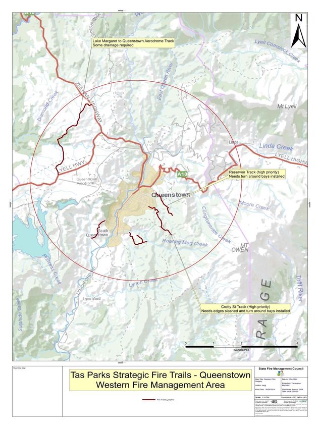
Community               An Emergency Management Plan for emergency managers and
Bushfire                responders. The Bushfire Response Plan aims to better protect
Response Plan           communities and their assets during bushfire emergencies, through
                        the identification of protection priorities and critical operational
                        information. These plans make firefighting resources safer and
                        more effective.
Consequence             The outcome or impact of a bushfire event.

Fire                    Classification system for the area to be managed. The zoning
management              system indicates the primary fire management purposes for an
Zoning                  area of land.

Human                   Term given for the GIS (Geographic Information Systems) dataset
Settlement Area         used to define where people live and work. The dataset was
                        developed for the purpose of risk modelling and was created using
                        a combination of building locations, cadastral information and ABS
                        data. Includes seasonally populated areas and industrial areas.
Likelihood              The chance of something occurring.
Risk                    The effect of uncertainty on objectives.2 (Note: Risk is often
                        expressed in terms of a combination of the consequences of an
                        event and the associated likelihood of occurrence.)
Risk acceptance         The informed decision to accept a risk, based on the knowledge
                        gained during the risk assessment process.
Risk analysis           The application of consequence and likelihood to an event in order
                        to determine the level of risk.
Risk assessment The systematic process of identifying, analysing and evaluating
                risk.
Risk criteria           Standards (or statements) by which the results of risk assessments
                        can be assessed. They relate quantitative risk estimates to
                        qualitative value judgements about the significance of the risks.
                        They are inexact and should be seen as guidelines rather than
                        rules.3
Risk evaluation         The process of comparing the outcomes of risk analysis to the risk
                        criteria in order to determine whether a risk is acceptable or
                        tolerable.
Risk                    The process of recognising, identifying and describing risks.
identification
Risk treatment          A process to select and implement appropriate measures
                        undertaken to modify risk.

2
  Standards Australia 2009, Risk management – Principles and guidelines, AS/NZS 31000:2009, Standards
Australia, Sydney, Australia
3
  Emergency Management Australia 1998, Australian Emergency Manuals Series – Manual 3 Australian
Management Glossary, Emergency Management Australia, Dickson, Australia

West Coast Fire Protection Plan 2018                                                                    6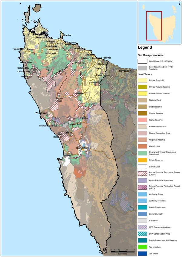
Acronyms

BPP                  Bushfire Planning & Policy

BRN                  Bushfire Ready Neighbourhoods

CPP                  Community Protection Planning

FIAT                 Forest Industry Association Tasmania

FMAC                 Fire Management Area Committee

FPP                  Fire Protection Plan

FRU                  Fuel Reduction Unit

STT                  Sustainable Timber Tasmania

LGA                  Local Government Area

PWS                  Parks and Wildlife Service

REMC                 Regional Emergency Management Council

SEMC                 State Emergency Management Committee

SFMC                 State Fire Management Council

TFGA                 Tasmania Farmers and Graziers Association

TFS                  Tasmania Fire Service

Maps contained in this document may include data provided by DPIPWE (Information and
Land Services Division (ILS), and Parks and Wildlife Service Fire Management Section), and
Tasmania Fire Service. These map products have been produced by the Tasmania Fire
Service. While all efforts have been taken to ensure the accuracy of these products, there
may be errors and/or omissions in the data presented. Users of these products are advised
to independently verify data for accuracy and completeness prior to use.

West Coast Fire Protection Plan 2018                                                   7
Chapter 1 Introduction
1.1 Background
Under Section 20 of the Fire service Act 1979, fire management area committees are
required to submit to SFMC, on an annual basis, a fire protection plan for its fire
management area commencing on 1 October 2014. The submission date was changed
to the 31st of December for 2016 and beyond.
It is a requirement of the fire protection plan that it is consistent with the State Fire
Protection Plan and the State Vegetation Fire Management Policy.
1.2 Aim and Objectives
The management of bushfire related risk is not the sole responsibility of any one land
manager but is a collective responsibility of the whole community. All members within a
community have a responsibility to assist with the management of bushfire risk.
The aim of this FPP is to document the cross tenure process of identifying and treating
bushfire-related risk within the West Coast Fire Management Area.
The objective of this FPP is to effectively manage bushfire related risk within the West
Coast Fire Management Area in order to protect people, assets and other things
valuable to the community.
In the first instance, the main objective of fire protection plans is to identify risk and
provide actions for the protection of communities at risk from bushfire. Risk based
planning places the highest priority on protection of human life followed by protection of
infrastructure and environmental values.
Specifically, the objectives of this plan are to:
Guide and coordinate a tenure blind bushfire risk management program over a
five (5) year period;
Document the process used to identify, analyse and evaluate risk, determine
priorities and develop a plan to systematically treat risk;
Facilitate the effective use of the financial and physical resources available for
bushfire risk management activities;
Integrate bushfire risk management into the business processes of Local
Government, land managers and other agencies;
Ensure integration between stakeholders;
Clearly and concisely communicate risk in a format that is meaningful to
stakeholders and the community; and
Monitor and review the implementation of the Plan, to ensure enhancements are
made on an on-going basis.
West Coast Fire Protection Plan 2018 8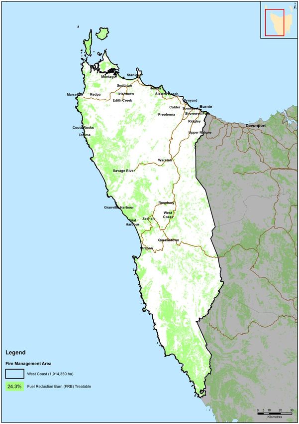
1.3 Context
South eastern Australia, including Tasmania, is particularly prone to fire and is regarded
as one of the most bushfire-affected regions in the world. It is neither possible nor
desirable to eliminate bushfires in Tasmania. Whilst bushfires are part of the natural
ecosystem processes of Tasmania and are essential for the maintenance of biodiversity,
its affects can be catastrophic if uncontrolled. Tasmania has experienced periodic
bushfire events that have caused devastating loss to life and property. In the aftermath
of recent catastrophic bushfire events a heightened focus has been placed on bushfire
risk identification and mitigation.
In recognition of the fact that bushfire is a landscape scale problem, the management of
which is a shared responsibility across all levels of government and both the public and
private arena, changes were made to the Fire Service Act 1979 that align the
administrative responsibility for the management of bushfire fuels across the State. The
fire management area committee (FMAC) structure, membership and committee
boundaries were reviewed and there are now 10 fire management areas for the State.
This reflects a broader landscape approach and strategic focus that is required to
effectively manage and mitigate the risk of bushfire.
In accordance with Section 18 of the Fire Service Act 1979, the following organisations
are represented on Fire Management Area Committees:
Local Government Authorities
Sustainable Timber Tasmania
Tasmania Fire Service
Tasmanian Parks and Wildlife Service
TasNetworks
Hydro Tasmania
Forico
Tas Water
State Emergency Service
State Fire Management Council
Natural Resource Management (NRM) organisations
The principal aim of the FMAC’s is to bring together the various stakeholders that
manage land use across the State, to work together to effectively manage vegetation
fuels for the mitigation of bushfires. The principle responsibility of a FMAC is to prepare
a tenure blind fire protection plan for its Fire Management Area.
West Coast Fire Protection Plan 2018 9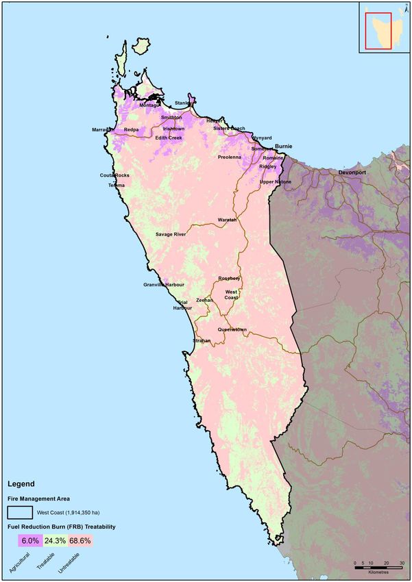
1.4    Tenure-blind fire management approach
Recent bushfire events across south eastern Australia have shown the importance of
strategic fuel management regardless of land tenure. The fact that bushfires move
through the landscape with no regard to property boundaries or tenure means that
cooperation is needed across property boundaries between land management agencies
and private property owners and occupiers in order to adequately address the threat of
bushfires in Tasmania.

Over time the focus of fire management activities has largely ended up with government
agencies managing public land. It is evident from recent fire events that focusing
mitigation efforts on public land alone will not be effective in addressing the risk of
bushfires. Managing the risks associated with bushfires will necessitate improving
community understanding and acceptance of the need to use prescribed burning
(together with a range of other treatment options) appropriately on private as well as
public lands.

West Coast Fire Protection Plan 2018                                               10
1.5 Policy, Standards and Legislation
The following policy, standards and legislation were considered to be applicable to the
development and implementation of the FPP.
Tasmanian Emergency Management Plan
State Fire Protection Plan
State Vegetation Fire Management Policy
State Strategic Fuel Management Report
North West Regional Emergency Management Plan
Municipal Emergency Management Plans
Standards
AS/NZS ISO 31000:2009 - Risk Management – Principles and Guidelines
National Emergency Risk Assessment Guidelines (NERAG)
Legislation
Aboriginal Relics Act 1975
Fire Service Act 1979
Emergency Management Act 2006
National Parks and Reserve Management Act 2002
Nature Conservation Act 2002
Crown Lands Act 1976
Forestry Act 1920 and Tasmanian Forests Agreement Act 2013
Threatened Species Protection Act 1995
Environmental Management and Pollution Control Act 1994
Local Government Act 1993
Forest Practices Act 1985 and Forest Practices Code 2015
Tasmanian Electricity Code
West Coast Fire Protection Plan 2018 11Chapter 2 Establishing the Context
2.1 Description of the West Coast Fire Protection Plan Area
2.1.1 Location and Boundaries
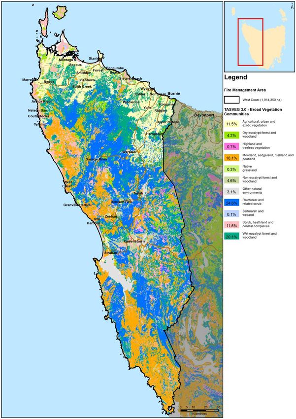
The West Coast Fire Management Area plan covers 1,914,350 ha. The Fire
Management Area extends westwards from the township of Heybridge on
Tasmania’s north-west coast to Cape Grim on the West Coast and southwards as
far as Davey Head. The fire management area encompasses Robbins Island,
Hunter Island and Three Hummock Island in Bass Strait.
The south eastern and southern portion of the fire management area encompasses
the Southwest Conservation Area as well as a large section of the Tasmanian
Wilderness World Heritage Area.
Significant human settlement areas within the Fire Management Area include:
Burnie
Wynyard
Smithton
Queenstown
Strahan
A map showing the boundaries of the West Coast Fire Management Area is
contained in Appendix 1.
West Coast Fire Protection Plan 2018 12There are four local government areas wholly or partially included in the West Coast
fire planning area including:
Circular Head Council
Waratah-Wynyard Council
Burnie City Council
West Coast Council
Figure 1: Local government areas – West Coast FMA
West Coast Fire Protection Plan 2018 132.1.2 Land Tenure
Within the West Coast Fire Management Area approximately 85% of land is public land
and 15% is private/freehold land.
An overview of the land tenure within the West Coast FMA is contained in table 1.
Tenure % of land
Private 15.4%
Forestry TAS (STT) 10.6%
Parks and Wildlife Service 69.6%
Crown 3.1%
Table 1 - Overview of tenure within the Fire management Area
A map showing land tenure within the West Coast Fire Management Area is contained in
Appendix 2.
The percentage of land that is private or freehold tenure within the West Coast FMA is
considerably lower than most other FMA’s across the state with the exception of the
Southern FMA (which has a similarly low amount of private/freehold tenure land of 14%).
Land tenure is important when considering how to manage bushfire risk on a landscape
scale. Government agencies responsible for management of the State’s public land
generally have arrangements in place for mitigating bushfire risk together with the
resources and necessary skills for planning for and responding to bushfire emergencies.
Many private property land owners do not have the resources, skills, knowledge or
experience to safely and effectively manage fire risk on their land. Further compounding
the complex issue of managing fire risk on private land is the fact that it is not co-
ordinated or carried out in a strategic manner. The issue of managing fire risk on private
land is possibly less of a problem in the West Coast FMA than for other FMA’s but
alternately leasehold or unallocated crown land (particularly land containing abandoned
mining leases) presents an equally challenging problem for the area.
West Coast Fire Protection Plan 2018 14Management of fire risk on private property
Under the Fire Service Act 1979 private landowners/occupiers in Tasmania, have a
number of legal responsibilities in relation to fire management, including undertaking fire
maintenance activities to ensure fuels on their property do not pose a risk to
neighbouring properties.
Privately owned land represents a considerable challenge to the effective management
of fire because there are currently some major barriers that limit the extent to which
landholders undertake planned burns. These include:
The risk of fire escapes. Privately owned land tends to be where the highest value
risk (human lives) are concentrated;
Potential liability of property owners from fire escapes;
Poor access to good weather/local forecast information;
Lack of fire management knowledge, skills and experience;
Lack of labour to manage the burn;
Lack of appropriate equipment to safely manage the burn;
Absentee land owners - many properties now have owners but not occupiers, for
example hobby farms and shack communities.
Other (Tasmania-wide) issues:
De-stocking of rural areas - land where fuels were once managed by grazing or
occasional burning, are left fallow and weeds or native vegetation fuels
accumulate.
Over time, fire preparedness and damage mitigation has given way to a
suppression-oriented approach. Communities have become reliant on fire
management agencies suppressing fire however suppression is unlikely in extreme
bushfire events.
There is an inconsistent approach amongst local Councils in relation to enforcing
fire abatement notices and provisions on private property.
There appears to be some concern and confusion in the community about a range
of fire related legal issues including vegetation clearing laws, fire permit
requirements, backyard burning restrictions and threatened species permit
requirements.
Population mobility and ageing. The number of people choosing to live in bush-fire
prone areas is increasing. As the population moves in and out of rural areas the
knowledge and awareness of people living in bush-fire prone areas diminishes.
Land use planning issues – in some areas residential development continues to be
permitted in locations with potentially extreme fire risk.
West Coast Fire Protection Plan 2018 152.1.3 Climate and Bushfire Season The climate of the West Coast Fire Management Area can be classified as temperate and is generally wet with a maritime influence. The climate in the fire management area is characterised by warm summers and cold winters in the northern coastal parts of the fire management area, together with mild summers and cold winters in the southern parts of the fire management area. Weather Observations There is ten Bureau of Meteorology (BOM) weather observation stations located within the West Coast Fire Management Area from which weather data are collected on a regular basis. They are located at: Cape Grim in the far north west of the Fire Management Area; Marrawah; Smithton; Wynyard; Burnie in the northeast of the Fire Management Area; Luncheon Hill; Mt Read; Strahan; Cape Sorrell in the central west of the Fire Management Area; Low Rocky Point in the south of the Fire Management Area West Coast Fire Protection Plan 2018 16
Summary Climate Statistics – West Coast FMA

Due to the extreme variation in weather data recorded from the ten BOM weather
observation stations across the fire planning area, climate statistics from three weather
stations (Marrawah in the north west, Mt Read in the centre of the fire planning area and
Strahan (Aerodrome) in the south of the fire planning area) have been selected to
provide a broad picture of weather observations for area.

    Mean Annual rainfall         Ranging from 1000mm in the north of the fire management
                                 area to more than 3600mm in the southern part of the fire
                                 management area

                                 1.     Marrawah weather Stn - 1070mm
                                 2.     Mt Read weather Stn - 3613.6mm
                                 3.     Strahan Stn – 1475mm
    Wettest months               1.     Marrawah weather Stn – July (mean rainfall 138.5mm)
                                 2.     Mt Read weather Stn – May (mean rainfall 395.7 mm)
                                 3.     Strahan weather Stn – Aug (mean rainfall 180 mm)
    Driest Months                1.     Marrawah weather Stn –Feb (mean rainfall 44mm)
                                 2.     Mt Read weather Stn – Feb (mean rainfall 174.4 mm)
                                 3.     Strahan weather Stn – Feb (mean rainfall 64 mm)
    Windiest Months              1.     Marrawah weather Stn – December (westerly)
                                 2.     Mt Read weather Stn – September (fairly uniform year
                                 round)
                                 3.     Strahan weather Stn – September
    Months of least wind         1.     Marrawah weather Stn – June
                                 2.     Mt Read weather Stn – uniform year round
                                 3.     Strahan weather Stn – February/March
    Cloudiest Month              1.     Marrawah weather Stn – May
                                 2.     Mt Read weather Stn – Not avail
                                 3.     Strahan weather Stn – August/September

Temperature and rainfall

Average maximum daily temperatures within the FMA range from 14.3° at Mt Read in
the centre of the Fire Management Area to 20° at Marrawah in the north in
January/February and 21.2° in February at Strahan in the south.

Average minimum temperatures range from 7° at Marrawah in the north in July to 5.1 °
in July at Strahan in the south, down to 0.1° at Mt Read in July.

The fire management area is characterised by moderate to high rainfall with a winter
dominant seasonal rainfall pattern and low summer rainfall. Winter is the wettest season
due to the influence of passing cold frontal systems on the area. The west receives
longer duration rainfall events than the north and east of Tasmania.

The FMA has an annual average of ten thunder days with the West Coast part of
Tasmania receiving more frequent thunderstorm activity than the rest of the state.

West Coast Fire Protection Plan 2018                                                  17
Figure 2: Mean annual rainfall across Tasmania Fire Management Areas. Wind The prevailing winds for the West Coast FMA are westerly. Spring is the windiest season with winds from the northwest increasing in the afternoons. Bushfire season A fire season is defined as the period of time in which fires are most likely to occur. Fire seasons can vary geographically and temporally. The fire season in the West Coast region of Tasmania extends from October to April. The extended period occurs due to the flammable characteristics of the moorland button grass and scrub vegetation complexes within the Fire Management Area. Statistics indicate that whilst the peak of the fire danger period in the west is in February, the month of January continues to support the highest incidence of fire starts. This correlates with the period of highest visitor use in the area together with a greater frequency of thunderstorms in the area in summer. West Coast Fire Protection Plan 2018 18
2.1.4 Vegetation
The range of vegetation communities found within the West Coast Fire Protection
Planning area is extremely diverse. The diversity within and between the vegetation
communities is related to variations in altitude, rock types, landforms and fire history
across the planning area. The non-vascular flora of the region (i.e. mosses, liverworts,
lichens and fungi) is very diverse because of the variability of vegetation coupled with a
very wet climate.
A substantial proportion of West Coast fire management planning area is formally
reserved with larger reserves within the planning area including part of Cradle Mountain
Lake St Clair National Park, Franklin – Gordon Wild Rivers National Park, the Southwest
Conservation Area (which all form part of the West Coast Tasmania World Heritage
Area) and Savage River National Park in the north of the planning area. The planning
area contains old growth forests as well as stands of Huon pine which are amongst the
world’s oldest living plants with individual trees known to reach an age of 3000 years.
The main vegetation associations in Tasmania have been mapped by the TasVeg
mapping program coordinated by the Department of Primary Industries Parks Water and
the Environment (DPIPWE). For the purposes of fire management, the complex
vegetation associations used in TasVeg have been simplified into 21 types and fire-
attributes (fire sensitivity and flammability ratings) have been developed for each type.
The broad native vegetation types occurring within the planning area and their
flammability ratings are shown in the below table and includes:
• Rainforest;
• Wet sclerophyll forest and woodland;
• Native non-forest vegetation (e.g. moorland, sedgeland, heath, rushland and
peatland);
• Scrub communities (scrub, heathland and coastal complexes);
• Non eucalypt forest and woodland;
• Dry sclerophyll forest and woodland;
• Other natural environments;
• Highland and Treeless Vegetation;
• Native grassland;
• Saltmarsh and wetland;
• Swamp forest (greatest in extent and diversity in the far Northwest (Woolnorth
Region).
Non native vegetation types occurring within the planning area include:
Agricultural, urban and exotic vegetation.
West Coast Fire Protection Plan 2018 19Broad Vegetation Group (TasVeg 3, % in FMA Veg
2013) Flammability
Rainforest and related scrub 24.6 Low
Wet eucalypt forest and woodland 20.1 Medium
Moorland, sedgeland, rushland and 18.1 Low – very high
peatland
Scrub, heathland and coastal complexes 11.5 High – Very
High
Agricultural, urban and exotic vegetation 11.5 Medium
Non eucalypt forest and woodland 4.6 High
Dry eucalypt forest and woodland 4.2 Medium - High
Other natural environments 3.1 N/A
Highland and Treeless Vegetation 0.7 High
Native grassland .3 High
Saltmarsh and wetland .1 Low
Total 100
Whilst the West Coast FMA contains a significant percentage of low flammability
vegetation types it also contains even larger amounts of highly flammable vegetation in
the form of buttongrass moorland, sedgeland, rushland and peatland as well as scrub
and heathland. Vegetation in the West Coast FMA in particular is well adapted to fire
and in recent times the area has experienced a high frequency of fast moving bushfires
which have burnt out large areas of the FMA.
A map and description of each of the broad vegetation community types contained in the
TASVEG mapping dataset and found in the West Coast FMA is contained in Appendix
3.
West Coast Fire Protection Plan 2018 202.1.5 Population and Demographics
The West Coast Fire Management Area has an estimated residential population of 44,
548 people (ABS 2016). The population density of the West Coast fire management
area is sparse, with less than 5 persons per square kilometre.
The main regional centres within the Fire Management Area include:
Burnie (population 18, 895 ABS 2016)
Smithton (population 3,881 ABS 2016)
Wynyard (population 6,001 ABS 2016)
The population trend on the West Coast, which contains many of Tasmania's mines, is
in decline. The west and north-west coast experience temporary increases in population
during the summertime with an influx of tourists to the area as well as holiday makers
inhabiting shack communities (including Trial Harbour, Granville Harbour, Pieman Head,
Macquarie Heads, Crayfish Creek, Rocky Cape, Temma, Couta Rocks, Sandy Cape,
Marrawah, Sundown Point and the Arthur River).
The West Coast municipality is a sparsely populated region with a total population of
approximately 4,149 people the majority of who mostly reside in the towns of
Queenstown, Strahan, Zeehan, Rosebery and Tullah. Principal occupations of the west
coast region revolve around mining, tourism, forestry and fishing.
The municipality of Circular Head in the far north west of the fire management area has
a population of approximately 8000 people and a population density of 1.7 people per
km2. Key industries in the area providing employment include dairying, forestry and
timber production, beef production, commercial fishing, aquaculture, iron ore pelletizing
and tourism.
A map showing the population distribution of the West Coast Fire Management Area is
contained in Appendix 4.
Manufacturing, retail trade and construction are the main industries and employers for
the north/north west region, employing 30% of the total workforce, followed by
agriculture, forestry and fishing and mining.
Other significant industries include dairy production and processing of agricultural
products.
Significant built infrastructure assets in the region include;
Burnie Port
Wynyard Airport (Commercial/night lit runway)
Power stations and transmission lines and hydroelectric dams
Savage River Mine and pipeline to Mawbanna as well as Port Latta Pelletizing
plant
West Coast Fire Protection Plan 2018 212.1.6 Bushfire Frequency and Causes of Ignition Fire frequency is defined as the number of times any one point in the landscape has been affected by fire over a period of time. Fire frequency records for the West Coast Fire Management Area have been obtained from records provided by the Tasmania Fire Service, Parks and Wildlife Service and Sustainable Timber Tasmania but the records are incomplete. Data for fires on private property is particularly lacking. Records that are available indicate that the number of fires and area burned per year has varied widely. The 2016 Wildfire season was particularly unusual due to the large amount of lightning ignition and the protracted nature of the firefighting effort. The vast majority (79%) of the fire management area has been untouched by fire since records started being kept. 15.5% of the Fire Management Area is noted as having been subject to fire at least once. Less than 6% of the fire management area has been subject to more than 2 or 3 fires at the same location. Events Major fire events in the region have been large in size with four large fire events over 36000ha in size since records began. The majority of fires (over 75%) occurring in the region have been under 100ha. It appears that there is a significant trend increase in the number of fires occurring in the
Fire Ignition Cause
The true causes of fire, either through ignition by lightning or caused by human actions
have not been well documented. TFS does not keep records relating to fire ignition
causes and they have only been documented by Sustainable Timber Tasmania and the
Tasmanian Parks and Wildlife Service since the 1980s. The leading causes of fires for
the West Coast fire management area (other than planned burns which accounted for
21.3% of fires) include lightning strike ignition (35.6%) and a range of human causes
(accidents, arson, campfire escape, escaped burns).

Analysis of existing records indicates that arson is a significant issue for the West Coast
FMA, particularly for PWS managed land. The principle causes of ignition within the
FMA are:

                       Ignition source             % of ignitions

                 Lightning                             35.6%

                 Planned burns                         21.3%

                 Unknown cause                         15.3%

                 Escapes from planned                  12.3 %
                 burns

                 Arson                                 10.5%

Lightning caused fires appear to be increasing significantly in the West Coast FMA in the
last decade, supporting Bureau of Meteorology observations on an increase in the
number of lightning days.

Maps showing fire history, frequency and causes of ignition for the West Coast Fire
Management Area are contained in Appendix 5.

West Coast Fire Protection Plan 2018                                                   23
Chapter 3 Analysing and Evaluating Bushfire Risk 3.1 Analysing Bushfire Risk Following the Australian Standard of risk (ISO 3100) bushfire risk has been considered spatially, assessing a combination of likelihood and consequence (PWS 2011). The Bushfire Risk Assessment Model (BRAM), model data run of November 2013 was used to analyse the landscape level risk for this plan. For a full analysis of the model, see Appendix 6. To determine overall risk the NERAG (National Emergency Risk Assessment Guidelines August 2010) document (see Appendix 7) was used. The level of risk is determined by combining consequences and likelihood (see Appendix 7). It must be noted that the BRAM and therefore the consequences, likelihood and risk outputs are based on available spatial data. The analysis has been undertaken on a state-wide basis, and maps are presented as complete for Tasmania. There are however gaps in the data inside and outside areas of public land. This includes fire history information, particularly on private land, which contributes to ignition potential information (likelihood), and many of the agricultural values have not been well captured (consequence). Notwithstanding these limitations, the model does provide an objective spatial analysis of bushfire risk in a landscape context. 3.2 Likelihood Likelihood is defined as a qualitative method to assess the likelihood rating to the consequences occurring. The likelihood of an event was generated by calculating ignition potential, suppression capabilities and fire behaviour potential, followed by assigning these output values to categories in a likelihood matrix. This is taken to mean the likelihood of a fire occurring in a specific area which surpasses the ability of the fire agencies to contain within the first 24 hours. West Coast Fire Protection Plan 2018 24
3.3 Consequence (values at risk)
Consequences are defined as a qualitative rating of damage from fire to values. The
consequences were taken directly from the output generated through the Values at Risk
spatial layer output.
Within the West Coast FMA there are a number of natural values at risk from fire
including the internationally significant Tasmanian Wilderness World Heritage Area as
well as areas of high value and specialty Timber (Huon pine, King William Pine,
Leatherwood etc.). The West Coast FMA also contains the West Coast Tasmania
Aboriginal Landscape National Heritage site whose heritage values may be at risk
through loss of grass cover and subsequent erosion of hut depressions and midden
sites following bushfires.
Other values that need to be understood when examining risk include the critical
infrastructure present.
Critical infrastructure within the West Coast FMA includes:
TasNetworks transmission and distribution lines and infrastructure and
communications network
Radio and telecommunications infrastructure
Gas pipeline and iron ore slurry pipe to Port Latta
Round Hill infrastructure (Chasm Creek)
Veneer mill, dry powdered milk plant at Smithton and Port Latta Processing plant
(major employers for the area)
Bastyan, Reece, John Butters and Mackintosh power stations
The (night time operational) airstrip and communications facilities at Strahan
King Billy Pine wood stave pipeline (Lake Margaret to Queenstown). This pipeline
has now been renewed using Oregon pine.
Savage River Township and Savage River Mine, Save River Pipeline to
Mawbanna
Other:
Waratah/Wynyard Council advised of explosives storage site at Que River, managed by
Forze Explosive Services (Minutes of NW EMC 10 Feb 2016).
West Coast Fire Protection Plan 2018 253.4 Overall Risk
A representation of risk (see Appendix 7) is developed when you combine the factors of
likelihood and consequence. The BRAM generated output map of risk shows qualitative
areas of risk, not areas of perceived risk.
The model assists in objectively defining areas where genuine risk is present. In-depth
analysis will indicate what factor is driving the risk for a given area.
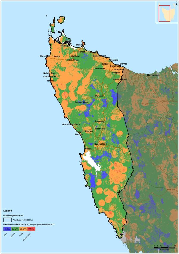
3.5 Risk Analysis for the West Coast Fire Management Area
The bushfire risk model BRAM was utilised to examine risk across the fire management
area. The results of this risk analysis are contained in a series of maps (BRAM - Bushfire
Risk Assessment Model Maps) showing likelihood of ignition, consequences and overall
risk within the West Coast FMA in Appendix 8.
BRAM modelling results for the West Coast FMA (Figure 3) indicate that areas of
highest bushfire risk identified for the West Coast FMA are scattered throughout the
FMA. Some extreme risk areas were identified around the settlements of Strahan and
Queenstown in the central West Coast part of the FMA as well as areas around Mt Read
and scattered patches across the north and north eastern part of the FMA.
As at October 2017 a total of 5.5% of the fire management area was identified as being
at extreme risk from fire under current fuel loads.
BRAM Bushfire Risk Assessment results for the West Coast Fire Management
Area:
BRAM level of Risk Area (ha) % of FMA
Low 34.3%
Moderate 32.9%
High 24.7%
Extreme 5.5%
West Coast Fire Protection Plan 2018 26Figure 3 – BRAM Overall Risk analysis results – West Coast FMA West Coast Fire Protection Plan 2018 27
3.6 Phoenix Ignition Points Modelling
In addition to BRAM modelling, Phoenix Rapidfire, a bushfire simulator, developed by
the University of Melbourne (Kevin Tolhurst and Derek Chong, 2008) was used to model
the risk of fires impacting on communities present in the FMA. An understanding of the
location of potential ignition points that may impact on communities is crucial. This
modelling was done as part of the state wide strategic fuel management assessment.
The process involved modelling potential ignition points, incorporating worst case
scenario weather patterns and examining fire behaviour based on current fuel loads to
identify the potential impact on human settlement areas.
The Phoenix modelling indicates that within the West Coast FMA ignition points of
potential concern (and possibly requiring risk mitigation activities) are located:
North west of Strahan
North west of Queenstown
North west of Zeehan
In the more heavily populated areas of the north coast including to the east and
south west of Burnie and west of Wynyard
South west of Smithton
It must be understood that such analysis has many limitations but does provide an
indication of where communities may be under risk as well as identify areas where
strategic burning will assist in changing fire behaviour.
A map showing the location of potential ignition points that may impact on communities
in the West Coast FMA under current fuel loads is contained in Appendix 9.
West Coast Fire Protection Plan 2018 283.7 Community Risk Assessment
Strategic assessment tools (including BRAM and Phoenix computer modelling) have
been used to conduct a broad scale assessment across the West Coast Fire
Management Area to identify communities vulnerable to bushfire. A more detailed
assessment using more locally specific processes was then conducted by members of
the FMAC.
Tools that were used by the FMAC to identify communities vulnerable to bushfire
include:
Consultation of Council and Emergency Services Risk Registers
Local knowledge obtained from Tas Fire Service District Officers and Brigades
BRAM Risk rating for West Coast FMA Human Settlement Areas
Phoenix modelled impacts
Consultation with Tasmania Fire Service Community Protection Planners and
Community Development Officers
Expert opinion of fire practitioners
Identification and consideration of existing and past fire management actions and
plans
Communities nominated in 2014 by the Tasmania Fire Service District Officer as being
high risk within the fire management area included:
Sisters Beach
Arthur River
Strahan
Zeehan
Port Latta
Crayfish Creek
Round Hill
Trial Harbour
Hellyer
Corinna
Consideration was also given to other assets of particular significance to the West Coast
FMA:
Agriculturally valuable locations/crops
Community assets (historic buildings, community halls etc.)
Ecologically special areas
Major infrastructure
West Coast Fire Protection Plan 2018 29 Large employment centres
Plantations (private and public)
A workshop was held in 2014 for FMAC members to discuss and analyse the results of
the preliminary risk assessment. Agreed ‘at risk’ communities were then prioritised by
members of the West Coast Fire Management Area Committee.
The results of the strategic assessment of communities at risk in the West Coast Fire
Management Area are outlined below in Table 3.
Suburb Name BRAM Rating FMAC Priority
Zeehan High-Extreme Extreme
Strahan High-Extreme High – V High
Sisters Beach High-Extreme Medium
Arthur River High-Extreme Medium
Port Latta Mod -High Med to High
Table 3 – Results of the Strategic Assessment
A map showing the location of communities identified as a result of the strategic
assessment process is contained in Figure 4.
A number of communities have previously been identified as being at high risk from
bushfire and already have specific bushfire response and protection plans in place,
these are summarised in Appendix 10.
Vulnerable Groups
Consideration was also given to a number of community groups and locations within the
FMA (camping areas in particular) that may contain people at risk from bushfire. The
following groups and locations were considered due to their isolation and close proximity
to heavily vegetated areas:
The Dogs Home above Emu River Valley
Emu River Valley residents
Cam River Valley residents
Recreational campers and tour companies
Crayfish Creek Caravan Park
Montagu Park Camping Area
Macquarie Heads camping area
Corinna wilderness lodge/settlement
Rosebery
The level of preparedness of residents and campers in these areas to respond to a
bushfire event is not known. These groups and locations are likely to already have been
given consideration in Local Council Emergency Plans and associated risk
assessments.
West Coast Fire Protection Plan 2018 30Special Issues for the West Coast FMA:
Abandoned and new mining leases represent a major fire risk for nearby
communities if they are not managed (they have absentee owners/managers) and
weeds/vegetation fuels are not controlled.
West Coast Fire Protection Plan 2018 31Figure 4 – Communities identified during strategic assessment process West Coast Fire Protection Plan 2018 32
3.8      Areas of strategic importance within the West Coast FMA
In addition to the above communities, areas of strategic importance were also identified,
shown in Table 4. These areas were identified through a process that utilised and
combined local knowledge, BRAM risk assessment and phoenix ignition potential
modelling. FMAC members with specific fire expertise and knowledge across the area
contributed to the identification of both the communities at risk and the broader strategic
areas for potential mitigation actions.

Table 4: Strategic areas for potential mitigation actions in the West Coast FMA.
 Potential treatment area                May provide protection for
 Fern Glade Conservation Area & Emu Havenview residential area (Burnie), the
 River Valley Reserve (south Burnie)     Wivenhoe industrial estate and the Lion
                                         dairy production factory (old Surrey Road)
 Gorse affected land around Zeehan       Zeehan township
 Strategic Fire Trails around Queenstown Queenstown
 Broom affected land around Waratah Waratah township
 township
 Strategic trails around Rosebery        Rosebery township
Maps of potential areas of strategic value for mitigation activities within the West Coast
FMA are contained in Figure 5.

Community Development and Education

Bushfire-Ready Neighbourhoods Program - Tasmanian Fire Service

A Community Development Coordinator and regionally based Community Development
Officers (Hobart, Launceston and Burnie) have identified 22 communities/areas state-
wide which are being targeted by the Bushfire-ready neighbourhoods program as part of
round 2 (2016 to 2018) of the program. The program takes a community development
(‘grass roots’) approach and recognises that there isn’t a one size fits all approach to
bushfire preparedness, highlighting that ‘we all play a part’ ( individuals, TFS,
communities). Specifically the program takes a community led approach providing local
community members in higher bushfire risk areas community engagement activities for
preparing for and preventing bushfire/s. The program is facilitated by accessing existing
community networks and resources and developing localised strategies in bushfire
preparedness. Some of the planned community engagement activities include;
community forums, information sessions for communities and brigades alike, workshops,
property assessments, field days, focussed group activities and establishment of
Bushfire-ready neighbourhood groups.

For more information about the Bushfire-Ready Neighbourhoods Program visit:
fire.tas.gov.au/brn

Round 2 Communities- 2016 to 2018 in the West Coast FMA are Sisters Creek, West
Coast (with a focus on Zeehan) and Cowrie Point to Rocky Cape.

West Coast Fire Protection Plan 2018                                                   33
Figure 5 – Areas of potential strategic value for mitigation activities – West Coast FMA West Coast Fire Protection Plan 2018 34
3.9 Strategic fuel management
Reducing fuel loads in strategic areas (usually through prescribed burning) is
undertaken with the intention of modifying the fire behaviour of any future bushfire and
creating an improved window of opportunity to control or contain bushfire events. The
basic strategy is to develop a mosaic of fuel reduced areas within specific parts of the
landscape over a time frame of several years. The application of a burning regime that
establishes a mosaic of burns can be used to ensure bushfire impacts are minimised. It
also ensures fire dependent flora species are maintained. Appropriate techniques may
include but are not restricted to such processes as fuel reduction burning, slashing,
mulching and fire break and trail construction.
Strategic fire trails
To be of strategic value, fire trails should be located in the following situations:
Adjacent to the assets which they are required to protect;
Lead to strategic water sources;
Break up large tracts of contiguous flammable vegetation;
To facilitate access and egress to assets;
To provide boundaries for prescribed burning blocks.
A comprehensive investigation and identification of strategic roads, fire trails, fire breaks
and fire infrastructure within the West Coast FMA has not yet been undertaken but has
been identified as a priority for future Fire Protection Plans.
West Coast Fire Protection Plan 2018 35Strategic Fire Trails – Queenstown: Preliminary investigation of a number of existing trails on Tasmanian Parks and Wildlife managed tenure surrounding Queenstown identified the location of trails with potential strategic value (Figure 6). Additional funding is required in order to bring the trails up to a standard appropriate for safe fire-fighting operations. Figure 6 – Areas of potential strategic value for mitigation activities – West Coast FMA West Coast Fire Protection Plan 2018 36
Chapter 4 Bushfire Risk Treatment
4.1 Region Wide Controls
The following controls are currently in place across the West Coast Fire Management
Area to assist in the strategic management of bushfire related risk:
Legislative controls – including abatements, fire restrictions etc.
Public education campaigns and the use of TFS Community Fire Safety
Programs and SFMC state-wide programs tailored to suit local needs; e.g.
Community Education – Bushfire Ready Neighbourhoods Program, Bushfire
Planning and Policy – Community Protection Planning and private land burning
programs (see Appendix 10 for further details).
State-wide arson prevention programs developed in conjunction with TAS Police
and TFS;
Setting of appropriate land subdivision and building standards in line with State
Bushfire Prone Area Building Standards;
Performance monitoring and reporting of FPP outcomes to the relevant
Emergency Management Council and State Fire Management Council as
required by the Tasmanian Emergency Management Plan and the Fire Service
Act
4.2 Asset Specific Treatment Strategies
There are five broad asset specific treatment strategies that have been used to manage
the bushfire risks identified in the Community Risk Assessment. They include:
Fuel management – Treatments include the reduction / modification of bushfire
fuels through manual, chemical and prescribed burning methods;
Ignition management - Treatments aim to reduce the occurrence of human
induced ignitions in the landscape;
Preparedness – Treatments focus on providing suitable access and water supply
arrangements that will assist with firefighting operations;
Planning – Treatments relate to the development of plans that will improve the
ability of firefighters and the community to respond to bushfire; and
Community Engagement – Treatments seek to build relationships, raise
awareness and change behaviours relating to the management of bushfire
related risks within the community.
West Coast Fire Protection Plan 2018 374.3 Treatment Options - Planned burning
Strategic fuel reduction burning is one treatment option with the potential to reduce risk
to some communities throughout the FMA.
In Tasmania, only certain types of vegetation are suitable for planned burning, for
example dry eucalypt forest, scrub, heathland and buttongrass. These are what can be
called ‘treatable’ vegetation types. Other vegetation types are unsuitable for planned
burning either because they are too wet to burn (such as sphagnum, swamp and
wetland), are extremely fire sensitive (rainforest, alpine/sub alpine coniferous heathland)
or have other characteristics such as land which is unvegetated or vegetation growing in
urban areas which make them unsuitable for planned burning. These unsuitable
vegetation types are considered ‘non-treatable’ for planned burning purposes.
Agricultural lands, whilst susceptible to the impact of bushfire, are also considered ‘non -
treatable’ due to the land use priority for these vegetation types. This does not preclude
these areas from burning however it means this area of land use type is not being
included in the analysis of treatable and untreatable vegetation.
Within the West Coast Fire Planning Area a total of 465,187 ha (or 24% of the total area)
has been categorised as Treatable. The remaining 72% of the fire planning area
(1,370,616 ha) has been classified as untreatable.
Fuel Reduction Burning Treatability –West Coast Fire
Management Area
West Coast (%)
Area (ha)
Treatable 465,187 24
Un-treatable 1320902 69
Water 48392 2
Agricultural 11486 6
Total FMAC Area 1914350 100.0
(ha)
A map and summary table showing treatability of land within the West Coast FMA is
contained in Appendix 11.
West Coast Fire Protection Plan 2018 38You can also read