Draft Regional Land Transport Plan 2015-2025 (2018 Review)
←
→
Page content transcription
If your browser does not render page correctly, please read the page content below
Draft Regional Land Transport Plan
             2015-2025
           (2018 Review)

                                     1
Month and Y

              2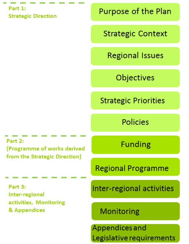
Contents

Introduction from the Chairman                                                         5
PART 1: FRONT END STRATEGIC DIRECTION AND CONTEXT                                      6
        Context of the Regional Land Transport Plan                                    6
  1.1   Purpose of the Plan                                                            6
  1.2   The Government Policy Statement on Land Transport                              7
  1.3   Regional and Local Government                                                  8
        1.3.1     Passenger Transport Committee and Regional Public Transport Plan     9
        1.3.2     Local Territorial Authority Asset Management Plans                   9
        1.3.3     Bringing It All Together                                             9
        Setting the scene                                                             10
  2.1   Regional Economy and its Impact on Transport Demand                           10
  2.2   Accelerate25 Regional Economic Action Plan                                    10
  2.3   Accessing Central New Zealand                                                 11
  2.4   Freight and other Heavy Vehicle Operations                                    13
  2.5   Rail                                                                          15
  2.6   Tourism                                                                       15
  2.7   Social Connections                                                            16
        Regional Issues                                                               18
  3.1   Issue 1: Land Use Pressures                                                   18
  3.2   Issue 2: Network Efficiency                                                   18
        3.2.1     Connections North                                                   18
        3.2.2     Connections South                                                   19
        3.2.3     Connections East                                                    19
        3.2.4     Connections West                                                    20
        3.2.5     Regional Rail Corridors                                             21
  3.3   Issue 3: Economic Development, Tourism and Growth                             21
  3.4   Issue 4: Road Safety                                                          22
  3.5   Issue 5: Local Roads and Freight                                              23
  3.6   Issue 6: Environmental                                                        23
  3.7   Issue 7: Resilience                                                           24
        Objectives                                                                    26
        Strategic Priorities                                                          28
  5.1   Rank 1: Effective and efficient road maintenance and delivery                 28
  5.2   Rank 2: Improve connectivity, resilience and the safety of strategic routes to
        and from key destinations linking north-south and east-west while factoring in
        demographic changes and impacts on land use                                    29
  5.3   Rank 3: An appropriate network of tourism routes.                             31
  5.4   Rank 4: An integrated walking and cycling network                             33

                                                                                        3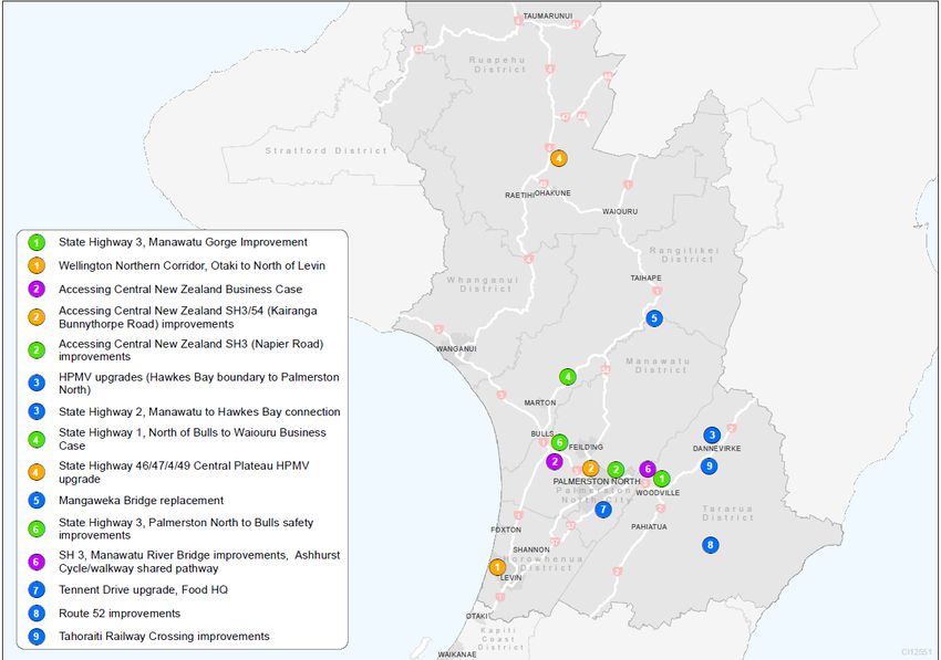
5.5   Rank 5: Effective, accessible and affordable multi-modal transport networks      34
        Policies and Measures to achieve the Priorities                                  36
PART TWO: DELIVERY OF THE STRATEGIC DIRECTION                                            44
        Funding the Plan                                                                 44
  7.1   Anticipated revenue sources                                                      44
        7.1.1     Revenue from the National Land Transport Fund                          44
        7.1.2     Contribution of road policing activity to the Horizons Regional Land
                  Transport Plan                                                         45
        7.1.3     Local Revenue sources                                                  45
  7.2   Other sources of revenue                                                         45
        7.2.1     Ten-year forecast of revenue and expenditure                           46
        Regional Programme of Transport Activities                                       48
  8.1   Prioritised List of Activities                                                   48
  8.2   Full List of Activities                                                          53
PART THREE: INTER-REGIONAL ACTIVITIES, MONITORING AND APPENDICES                         63
        Inter-regional Activities                                                        63
        Monitoring of the Plan                                                           66
        Appendices                                                                       67
Appendix 1: Legislative alignment with the LTMA                                          67
Appendix 2: Accessing Central New Zealand                                                69
Appendix 3: Key findings of the 2010 Joint Transport Study                               72
Appendix 4: Statistical information and population information                           76
Appendix 5: SH 43 (Forgotten Highway) Joint Statement                                    82
Appendix 6: Legislative Requirements and Policy Framework                                83
Appendix 7: Significance Policy                                                          84

                                                                                          4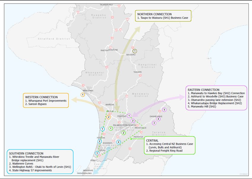
Introduction from the Chairman
As chair of the Horizons Regional Transport Committee, I am pleased to present to you the 2018
Review of the Horizons’ Regional Land Transport Plan 2015-2025 (the Plan).

This review is a requirement under changes to the Land Transport Management Act 2003,
introduced in 2013. Regional transport committees are required to develop a regional land
transport plan, in consultation with their community and stakeholders every six years. These plans
are required to be reviewed every three years. This plan is the result of a three-yearly review of
the 2015-25 Plan.

The Plan is a ten-year document. Its sets out the strategic direction for land transport in the
Horizons Region. It states the regional priorities for the next ten years and outlines the proposed
land transport activities in the next six years that seek to contribute to these priorities and secure
and guide investment in the Region. This document has been developed in partnership with our
regional partners with agreement on which activities we want to pursue and in what order of
priority. Based on the Plan, the New Zealand Transport Agency will decide which activities it will
include in the National Land Transport Programme (NLTP). Once included in the NLTP, an activity
can then be funded from the National Land Transport Fund and subsequently delivered.

One of the key priorities for the Region is the planning and implementation of a cohesive and
resilient transport network to, from and within the Region. If this is well planned, efficient and
strategically connected to our key population centres and freight and logistic hubs, it will allow for
the smooth and efficient movement of freight and people in the region which will in turn assist in
economic growth for the Region. There are two key programmes underway which will contribute to
achieving this. These are the Accelerate25 Economic Action Plan and Accessing Central New
Zealand (ACNZ). Accelerate25 outlines the strategy for unlocking economic growth in the Region
through nine initiatives for investment and four key enablers to unlock this investment. Leading on
from Accelerate25, the ACNZ group are focusing on a number of connected strategic projects to
achieve the goal of a safe, resilient and cohesive transport network to, from and within the Region.
Growing the profile of ACNZ will in turn realise the goals of Accelerate25.

In addition a number of significant infrastructure projects have been identified across the Region.
Finding a viable alternative to the Manawatū Gorge is an immediate priority. In conjunction with this
project, is the building of the Regional Freight Ring Road and the upgrading of Ōtaki to Levin
section of the Wellington Northern Corridor. All three projects will allow for easier movement of
freight through Central New Zealand and will have far reaching benefits for our communities and
beyond.

The Plan underpins and takes into account previous work undertaken at a national and regional
level, such as the Government Policy Statement (GPS) on Land Transport Funding 2015-2025, the
draft GPS 2018, the 2010 Joint Transport Study, the Region’s Economic Development Action Plan
(Accelerate25) and Accessing Central New Zealand. The Committee is satisfied that this Plan is
consistent with these documents.

Part One of the Plan identifies the Region’s land transport issues and challenges. Objectives,
policies and measures have been identified in subsequent sections to address them as the Region
works towards its strategic vision for the future.

Activities identified in Part Two of the Plan seek to address these priorities in the near future.

On behalf of the Committee, I would like to thank all of those individuals and organisations that
contributed to the preparation of this document. I look forward to working with you in delivering
optimal land transport outcomes in the future.

Councillor E B (Bruce) Gordon
Chair, Horizons Regional Transport Committee.
                                                                                                     5
PART 1: FRONT END STRATEGIC DIRECTION AND CONTEXT

      Context of the Regional Land Transport Plan

1.1 Purpose of the Plan

The Horizons Regional Land Transport Plan (the Plan) sets out the strategic direction for land
transport in the Manawatū-Whanganui (Horizons) Region over the next ten years. It describes what
our Region is seeking to achieve for the land transport system in order to contribute to an effective,
efficient and safe land transport system in the public interest as required under the Land Transport
Management Act 2003 (LTMA). It also focuses on and enables economic growth as well as social
benefits and environmental sustainability throughout the Region.

The Plan also incorporates the programme of land transport activities the Region wishes to
prioritise for inclusion in the National Land Transport Programme (NLTP) for subsequent funding
investment via the New Zealand Transport Agency (NZ Transport Agency). The Plan has been
developed by the Horizons Regional Transport Committee (RTC) on behalf of Horizons Regional
Council in collaboration with key regional transport partners and stakeholders. For further detail on
the plan development process in accordance with statutory requirements under the LTMA, and
other matters taken into account, please refer to Appendix 6.

How to use this Plan:

The following diagram shows how the three parts of the plan work:

                                                                                                    6
Part One of this document sets out the strategic direction for the Region. It identifies the key
transport issues (problems) that face our regional land transport system over the next 30 years.
Objectives (benefits) have been formulated in response to these issues and are the outcomes
being sought for the transport network. Also in Part One are the strategic priorities for the Region.
The strategic priorities are the key areas of focus and will guide investment in the land transport
network for the duration of the Plan. Below the strategic priorities are a suite of policies which
outline how each strategic priority will be achieved.

Part Two identifies the key programmes which will deliver on the overarching strategic direction of
the Plan. The detailed programmes and specific projects within Part Two link to the strategic
direction and priorities of the Plan. Significant programmes are ranked according to their level of
significance and alignment with the strategic direction of the Plan. The programmes have been
formulated in collaboration with the Region’s Territorial Authorities and the NZ Transport Agency.
They take a regional holistic view to seek an integrated land transport system as well as focusing
on respective local issues.

Part Three incorporates the significant inter-regional activities, plan monitoring and appendices.
The appendices include legislative requirements, statistical information, further information on key
projects and the significance policy which provides guidance on the threshold for a significant
activity and consultation requirements.

1.2 The Government Policy Statement on Land Transport

The legal policy framework for all land transport activities in New Zealand is set by the Ministry of
Transport which is headed by its Minister and supported by a group of Central Government
organisations which have responsibility for land transport in New Zealand.

The key to shaping the Plan is the requirements set out in the Land Transport Management Act
2003 as well as the Government’s objectives and priorities as expressed through the Government
Policy Statement on Land Transport Funding 2015. The recently released draft Government Policy
Statement 2018/19-2027/28 (GPS 2018) continues these key overarching themes. A date for the
publishing of the final GPS 2018 is yet to be announced.

The Government has a strong focus on driving improved performance from the land transport
system and investing in new transport infrastructure. This is primarily articulated through the GPS.
The GPS sets out the strategic direction for land transport in New Zealand and outlines the results
the Government wishes to achieve from allocation of transport investment from the National Land
Transport Fund (NLTF). This Plan must be consistent with the GPS.

The GPS 2018 draft engagement document was released February 2017 and the Government’s
strategic direction for land transport is to continue to pursue improved performance from the land
transport system by focusing on three core priorities:

•    economic growth and productivity;
•    road safety; and
•    value for money.

The GPS 2018 also sets out national land transport objectives and the long term results the
Government wishes to achieve under each objective. The objectives seek a land transport system
that:

•    addresses current and future demand;
•    is reliable and resilient;
•    is a safe system, increasingly free of death and serious injury;
•    delivers the right infrastructure and services to the right level at the best cost;
•    provides appropriate transport choices; and
                                                                                                   7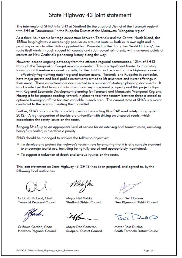
•     increasingly mitigates the effects of land transport on the environment.

Through the review of this Plan, it is has been determined that the strategic direction and vision of
this document is consistent with the operative 2015 and draft 2018 GPS.

New Government
In October 2017, a new coalition government was formed between the Labour, NZ First and Green
parties. Correspondence from the new Minister of Transport has indicated that the draft GPS will
be amended to reflect the Coalition Government’s key areas of focus for Transport, with an
updated draft circulated in early 2018. The exact content of the amended draft GPS is unknown at
the time of writing, however the Minister has highlighted the areas of Government focus and
suggested Council’s consider these when developing their RLTPs. The areas of focus are:
•     giving public transport greater priority in cities and expanding the public transport system to
      support new housing and interregional commuting;
•     increasing the use of rail to enable efficient passenger and freight use;
•     supporting regional development;
•     increasing support for active modes – walking and cycling;
•     delivering health, safety and environmental improvements;
•     reducing the environmental impact of transport;
•     mode neutrality in freight transport planning.

These areas of focus have been considered and weaved into this document.

By achieving the regional objectives set out in the Plan, the Horizons Region will contribute to
achieving the transport priorities for the country driven by the GPS.

Long Term Strategic View

In May 2017, the NZ Transport Agency released the first national Long Term Strategic View
(LTSV) document that is the first step towards a shared view of the transport system. This
document has been developed partly in response to a number of queries and concerns that there
is no nationally set long term vision for the transport network. The intention is that this strategic
view will allow the sector to work more effectively together to shape the future transport system.
The document captures areas and pressure points of the network that are shaping the future
network, including the key contributions that transport can make to New Zealand’s economic and
social well-being. These are:

       1. A safer system;
       2. An effective urban system;
       3. Better connectivity;
       4. A resilient system;
       5. Key Inter-regional journeys; and
       6. Regional economic development (REDS) areas.

The key opportunities and challenges identified for the Horizons Region and wider Lower North
Island context in the LTSV are well captured and embedded within this RLTP.

1.3 Regional and Local Government

At a local level, the territorial authorities of the Region are responsible for the management of local
roading networks, while the regional council has statutory transport planning responsibilities
through establishment of the Regional Transport Committee (RTC).

The RTC is made up of representatives from Horizons Regional Council, the region’s district and
city councils, the NZ Transport Agency and advisory members representing transport interest
groups. The preparation and delivery of this RLTP on behalf of the regional council is a key
                                                                                                     8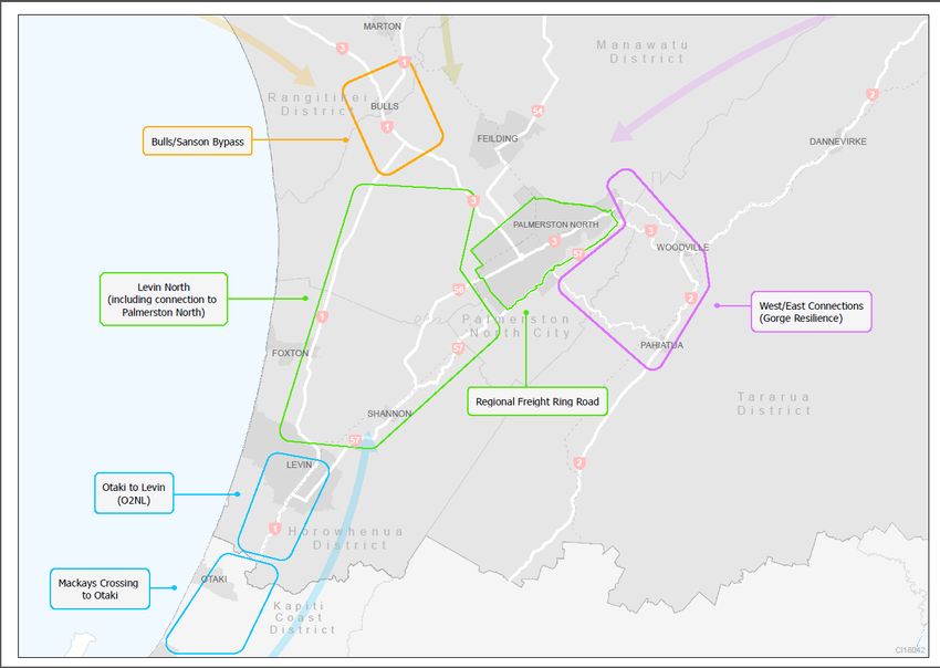
function of the RTC set out in the Land Transport Management Act 2003.

1.3.1 Passenger Transport Committee and Regional Public Transport Plan

The regional council is also responsible for the identification of essential public transport services
and the provision of those services where necessary. This is primarily undertaken by Horizons’
Passenger Transport Committee (PTC) that sits alongside the Regional Transport Committee.

The PTC’s key document in the planning and implementation of the Region’s passenger transport
services is the Regional Public Transport Plan 2015-25. This document sets out the framework for
the provision and development of services and infrastructure integral to public transport in the
Region. The Regional Public Transport Plan is consistent with the Regional Land Transport Plan
for those matters that are covered in both plans.

1.3.2 Local Territorial Authority Asset Management Plans

Asset Management Plans (AMPs) for transport and roading related assets are developed by each
territorial authority within the region. These plans implement the maintenance, renewal and
delivery of transport projects, which in part, forms the basis of Regional Land Transport Plan
programme. While the vision and strategic policy direction is set at the regional level, the project of
works to physically deliver on improving the regional land transport network is actioned by much of
the programmed works contained within the local AMPs. The AMPs therefore provide the vehicle
to action a lot of the identified transport opportunities for the wider region signalled in the RLTP.

1.3.3 Bringing It All Together

The review of the RLTP has focussed on ensuring the vision and strategic direction is aligned
nationally, regionally and locally, which is vital for an effective, strategic, integrated regional land
transport network and for unlocking future economic growth.

                                                                                                      9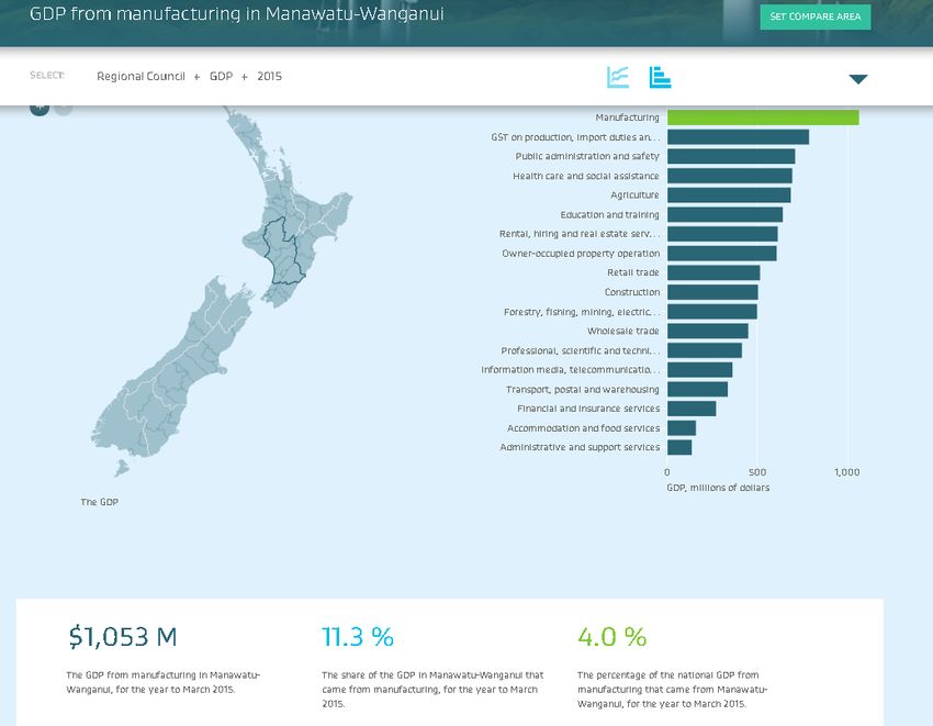
Setting the scene
The Manawatū-Whanganui (Horizons) Region is a predominantly rural region with a few main
centres of population. It lies in the lower central North Island, and because of its central location, it
has important land and air transport connections to the rest of New Zealand.

The Region is home to around 5%1 of New Zealand’s population and accounts for around 4% of
national GDP2. With that said, recent economic growth analysis undertaken by ASB3 (Regional
Economic Scoreboard) shows the Region to be sitting 5th in terms of economic growth at the June
2017 quarter. In October 2016, the Region was sitting at 14th which coincides with when Statistics
NZ last released their GDP figures. In light of the recent information released in the ASB report,
the Region’s GDP contribution is likely to be higher now, given the high ranking for economic
growth in the Region in 2017.

Economic outcomes vary across the Region and while it has not experienced the population and
economic growth of some of the more densely populated regions in New Zealand, it has a number
of unique features that contribute to the way in which goods and people are transported within, to
and from the Region.

The Palmerston North - Manawatū sub-area is now recognised as the hub of the growing freight
distribution industry because of its location in the central part of the lower North Island, connecting
to the surrounding regions of Taranaki, Hawkes Bay, Waikato and Wellington via the State
Highway, rail and air networks. However, the hubbing concept is not limited to Palmerston North.
Whanganui also has a growing hubbing centre based on the Heads Road Industrial Estate, and
there is potential for future hubbing growth in the Horowhenua District once the Wellington
Northern Corridor project, which is expected to extend from Wellington Airport to north of Levin is
complete. A key outcome of the Plan will be to strengthen this growth by having strong links to the
Regional Growth Study, Accelerate25 and Agribusiness Strategy.

Further statistical information on the Region’s population and economic is continued in Appendix 4.

2.1 Regional Economy and its Impact on Transport Demand

The regional economy is largely based on the production of primary industries, and because of
this, the Region’s economy is reliant on the land transport network in transporting product from its
point of origin to its destination. Analysis undertaken by the Ministry of Business, Innovation and
Employment shows that the manufacturing, agriculture and forestry industries, contribute to a
significant portion of the Region’s GDP (for a breakdown of this information, please see Appendix
4). These industries rely heavily on transport networks. A large proportion of the Region’s primary
product eventually makes its way out of the Region for either export overseas or to be redistributed
to other parts of New Zealand. Therefore, it is critical to the economy of the Region that transport
links are resilient and efficient (which includes a high level of connectivity).

2.2 Accelerate25 Regional Economic Action Plan

In 2015 a Government driven Regional Growth Study was undertaken to provide an in-depth look
at the economic opportunities for the Horizons Region. This study recommended eight key
opportunities and three enablers. The subsequent Action Plan (Accelerate25) derived from the

      1
        Regional Economic Activity Report, 2016, Ministry of Business, Innovation and Employment
      2
        Statistics New Zealand figures for 2016.
      3
        The Main Report Group, Regional Economic Scoreboard, June 2017 quarter https://www.asb.co.nz/documents/economic-
      research/regional-economic-scoreboard.html

                                                                                                                    10
Growth Study findings provides the practical application for realising these opportunities, unlocking
new levels of prosperity and growing our regional economy out to 2025. Accelerate25’s
Manawatū-Whanganui Economic Action Plan (Action Plan) goes a step further and has a total of
nine key opportunities and four enablers for realising economic growth in the Region. The four key
enablers are:
• Growing Business
• Skills and Talent
• Distribution and Transport
• Digital Connectivity
‘Distribution and Transport’ has been identified as a key enabler in unlocking potential economic
growth and realising all nine opportunities in the Action Plan. Transport as an ‘enabler’ of unlocking
economic prosperity has huge potential to drive a lot of the work outcomes in the Action Plan,
identified as immediate, medium term and future priorities for the Region, a key focus of which is
Accessing Central New Zealand (discussed below) and this is very much at the forefront of our
thinking in putting this document together. Having a unified approach to enabling economic growth
will lead to improved social and cultural well-being. This approach is reflected in the Objectives
and Policies included within this Plan. How it will be achieved is demonstrated in the six year
programme of works.
2.3 Accessing Central New Zealand
As signalled in Accelerate25’s Manawatū-Whanganui Economic Action Plan, the central location
has seen the Region develop as a key freight and distribution hub in New Zealand, taking
advantage of its strategic and centralised geographic location. Strategic planning to maximise this
hubbing opportunity has been previously driven by the Joint Manawatū-Palmerston North
Transport Strategy (JTS). The JTS was developed in 2010 in collaboration with Palmerston North
City Council (PNCC), Manawatu District Council, Horizons Regional Council and the NZ Transport
Agency in response to poor strategic alignment. The JTS identified a series of road improvements
to give effect to an evidence-based strategic network hierarchy, connecting key transport nodes
over the next 30 years. This strategic planning has been superseded by Accessing Central New
Zealand (ACNZ) which is a subgroup of the Regional Transport Committee and is tasked with
overseeing projects that give life to the Distribution and Transport enabler of Accelerate25. The
theme of ACNZ is to allow for the efficient movement of goods and commodities into and out of the
region along the key transport corridors. This is depicted in Figure 1 below.
11Figure 1. Map of Accessing Central NZ Project Area showing projects to date being worked on.
A key aspect of the JTS has been the development of a ‘Regional Freight Ring Road’, vital to
unlocking the Region’s distribution and logistics potential and reducing large commercial traffic
volumes on local roads. This along with other projects established out of the JTS have now been
incorporated into a wider strategic case for transport investment through ‘Accessing Central New
Zealand’ as a part of Accelerate25.
The exact Regional Freight Ring Road route is yet to be confirmed, however, it will fully
encompass Palmerston North providing strong connections to the Ruapehu, Manawatū, Rangitikei
and Whanganui districts to the north, Tararua district to the east, and the Horowhenua district to
the south therefore connecting to the industries these areas harbour. The Regional Freight Ring
Road also intends to provide fluid connectivity with State Highway 3 to the northwest (Taranaki),
State Highway 1 to the south (Wellington) and State Highway 2 to the east (Hawkes Bay). To
achieve the overarching vision, some of the project work will fall under the jurisdiction of PNCC as
local roads, and other State Highway sections under the NZ Transport Agency. Additional
information on the JTS, including an indicative route for the Regional Freight Ring Road, is
provided in Appendix 3 of this document. It is important to note that at the time of writing, the
Manawatū Gorge had recently been closed and its new replacement route is yet to be confirmed.
The location of replacement route may result in some of the eastern sections of the Regional
Freight Ring Road changing to ensure adequate connections to any future eastern inter-regional
connection.
While the Regional Freight Ring Road is a key cornerstone of maximising the strategic central
location and hubbing potential, the success of A does not just end with its completion. There has
now been a realisation that Accessing Central New Zealand needs to look beyond this. Access
from south of Taupō, north of Ōtaki, and from Central Hawkes Bay through to the Stratford District
is now being considered as part of the wider picture for transport connections to and from the
Region. This wider focus aligns well with Strategic Priority Two of this document which focuses on
12improved connectivity, resilience and safety of strategic routes to and from key destinations.
Efficient, ‘whole of network’ access to and from the wider area that provides good inter-modal
freight opportunities is the higher aim of Accessing Central New Zealand.
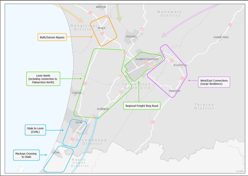
Figure 2 demonstrates the key connection areas for the Region that needs to be planned for in
unison and be well connected. More detail on work programmes associated with ACNZ is included
in Appendix 2 of this document.
Figure 2: Accessing Central New Zealand key north-south and east-west connections for the
Horizons Region
2.4 Freight and other Heavy Vehicle Operations
The Palmerston North-Manawatū sub area is now a major freight hub and has superseded
Wellington in importance as a distribution centre. This is as a result of two important commodity
flows:
• Palmerston North has become a key staging point for high value imported and domestic
freight between Auckland and Wellington or between Auckland and the South Island; and
• Palmerston North has good access to hinterlands that produce New Zealand export
commodities and provides the staging point for export of these out of the ports in Napier,
New Plymouth and Wellington, and possibly even Auckland and Tauranga.
Recent examples of this growth are:
• The creation of an inland port at Longburn through a collaboration of the Ports of Auckland
and Napier, and Halls. This inland port is within a wider industrial zone known as the
Braeburn Industrial Area that is earmarked for future expansion; and
13• Palmerston North City Council investigating a 126 hectare extension of the North-East
Industrial Zone through its Sectional District Plan review process to accommodate expected
growth in the zone.
Whanganui has also become an important freight distribution centre recently, providing the primary
sector with good road and rail transport routes to markets.
The National Freight Demands Study 2014 provides a snapshot of New Zealand’s current freight
task and a forecast of what it will look like over the next 30 years. The Study has estimated that the
three most important destinations of freight from our Region in 2042, will be Taranaki with an
estimated 2.59 million tonnes of freight, Wellington (1.81 m/tonnes) and Hawkes Bay (1.02
m/tonnes). The most important origins of freight for our Region will be Auckland (2.40m/tonnes),
Hawkes Bay (1.48m/tonnes) and Wellington 1.42 (m/tonnes). Auckland, Taranaki, Hawkes Bay
and Wellington, therefore, are the key origin and destinations for freight entering and leaving the
Region. Well established connections will be key in moving freight efficiently and effectively into
and out of the Region during the lifetime of this Plan.
The Regional Growth Study and Agribusiness Strategy investigated ways to unlock further growth
over the next 30 years. Transport is a key enabler of growth and discussed below are some of the
key sectors of the economy.
Agriculture
The Central New Zealand Agribusiness Strategy investigated ways to increase the Region’s
agribusiness exports from $1.9 billion to $3.8 billion by 2025. The Region contains 18% of all
Class 1 soils and 14% of all Class 2 soils in New Zealand. These are considered to be the most
versatile soils for agriculture and horticulture and there is potential for further growth around the
use of these soils. Accordingly, agriculture (including: horticulture and fruit growing; sheep, beef
and livestock farming; dairy farming; other farming services to agriculture; and hunting and
trapping) is one of the Region’s most important enterprises. Farmland is used more intensively
than in the past which has led to increased dairy farming and more intensive livestock production.
This intensification of the land will have long-term implications for the Regions transport networks,
with increasing numbers of heavy vehicles servicing these industries.
Dairy and meat processing
The dairy supply chain is complex, with varying degrees of movement throughout the Region to
processing plants both within and outside the Region. Nationally, around 50% of dairy products
are moved by rail. However, in our Region this is higher due to the milk conveyed from the
processing facilities at Oringi and Longburn to the Whareroa plant in Hawera. There is also a large
counter flow from Hawera to the Port of Napier, with finished product being sent for export from
Napier.
There are a number of meat processing facilities in the Region that contribute to it having the
largest volume of stock movements in the country. About 44% of meat is conveyed by rail around
New Zealand as many meat processing plants have railway sidings. Most meat processed within
the Region that goes for export is transported to either the Ports of Tauranga or Napier.
FoodHQ
Adding value to food exports through food innovation is a growing part of the regional economy
and will be a key enabler of regional growth into the future. Key to this is the FoodHQ collaboration
based at Massey University, which is also recognised as a key opportunity in the Accelerate25,
Economic Action Plan. Plans are in place to merge the current Massey University campus with the
Fitzherbert Science Centre to create a ‘one campus’ feel. Changes may be required to the
transport network around and through the campus in order to enable the full growth potential.
Forestry
Forestry is likely to contribute more to the economy in the years between 2020 – 2030, as much of
the Region’s forestry estate reaches its harvestable age. However, the timing of harvesting will
14generally be dictated by the commodity price at the time. There are large plantations of forest in
the Rangitikei, Ruapehu and Whanganui Districts, accounting for more than 75% of the total land
area planted with radiata pine in the Region. Most of the logs will get transported via road,
particularly local roads, but in some instances will be transported by rail. Most logs get exported
via the Ports of Napier, Taranaki and Wellington (CentrePort).
Time is criticality important in freight distribution, and with all of these freight dependent industries
in our Region, efficient and effective transport networks are key in order to meet the demands of
time critical transport.
Centralisation of Defence Force Operations
The Government has signaled the centralisation of defence forces in the Country. This means that
the Linton and Ohakea defence bases may increase in size. A recent study undertaken at Linton
Military Camp assessed the key routes for their defence vehicles. The study analysed traffic flows
into the Camp and the surrounding Linton Community (which includes housing areas and a
number of other businesses such as, NZ Pharmaceuticals, Spotless and the Manawatū Prison).
The study logged a total of 75,992 vehicles entering Linton Military Camp per month and a total of
103,040 vehicles per month to surrounding businesses and housing areas. This is a significant
volume of traffic which would only increase if forces are centralised and the base becomes bigger.
Resilient, efficient and safe roading connections to both Linton and Ohakea are therefore important
and will become more important to meet demand as these bases become centralised.
2.5 Rail
The Horizons Region has long advocated for better utilisation of existing rail infrastructure for the
movement of freight to and from the region. The existing rail infrastructure could also be better
utilised for the movement of people, particularly in the tourism market. The North Island Main
Trunk line features prominently within our region with the Central North Island north-south/east-
west junction being located in Marton. Over time the utilisation of this asset has declined and given
the region’s economic growth aspirations, in particular under the Accelerate25 banner, the
resurgence of this transport mode is seen as vital to the success of Accessing Central New
Zealand, and is therefore very much supported.
2.6 Tourism
The regional tourism industry is largely reliant on the domestic tourism market, with no international
airports or seaports in the Region. Most tourists will enter the Region via the land transport
network rather than by air or sea and as free independent travellers rather than on organised tours.
The Region accounts for 4.3% of tourism spend4 within New Zealand. Recent information
indicates a 7% increase in tourism spend in the Region in the three months ending September
20175. There are multiple tourist destinations within the Region, such as Ruapehu, Whanganui,
Rangitikei and Palmerston North, catering for both domestic and international tourism. One of the
key tourist destinations in the Region is Palmerston North, accounting for about 40% of all regional
tourism spend. Due to its central location, having the second largest regional airport in the country
and ease of access, it is a major domestic conference and sporting venue which accounts for a
large amount of its domestic tourism visits. The airport also provides a gateway for both domestic
and international tourism to the Rangitikei, Whanganui and Ruapehu districts. This contributes
strongly to the tourism market in the Region due to the presence of major recreational attractions
such as the Tongariro and Whanganui National Parks in these districts. These attractions
generally mean a greater proportion of international visitors to the Ruapehu and Whanganui
districts but do also cater strongly to the domestic tourism market. The Rangitikei district is also
emerging as a popular tourist destination.
4
Ministry of Business, Innovation and Employment / Infometrics
5
Information supplied by Palmerston North City Council’s Economic Advisor and is based on information from Statistics
New Zealand.
15The Accelerate25 Economic Growth Study and subsequent Action Plan recognise opportunities to
grow the region as a destination for adventure, nature, cultural and outdoor tourism experiences.
Current tourism activity has been described as widely distributed, somewhat fragmented, and
generally small scale in nature and performing at a lower level than it could be. Initial intervention
as part of the Action Plan to unlock the tourism potential is primarily targeted in the Ruapehu and
Whanganui Districts.
The Ruapehu and Whanganui Districts have two of the ‘Great Rides’, that comprise the national
cycleways network, Nga Haeranga: The Timber Trail and the Rivers to Sea cycle trails. The trails
are the ‘premier’ rides on the network. In recent years the network of cycle routes has been
expanded to include a number of on-road cycle touring routes, with the long-term aim of
developing a nationwide cycling network, enabling locals and international visitors to explore all of
New Zealand by cycle. All or part of the following ‘cycle touring routes’ are in the Region:
• Manawatū Cycleway
• Mountain to Sea Connection
• Tararua Traverse
• The Gentle Annie
• The OTT Trail (Ohakune to Taihape Trail)
• Pureora Timber Trail Connection
• Te Araroa walkway
2.7 Social Connections
The Manawatū-Whanganui Region is home to around 5% of the New Zealand population, with
approximately 6% of the Country’s over 65s residing here. In recent years, population growth has
increased in the region, with all districts seeing an increase between 2015 and 2016. Statistics
New Zealand’s population growth projections, which are based on population estimates rather than
usually resident population figures, indicate an expected overall 6% increase in the Region’s
population by 2043 (medium growth scenario)6.
A land transport network that recognises demographic changes and population growth is important
for providing integrated, effective transport linkages that allow people to live, play and work in their
communities.
All territorial authorities in the Region are expected to see large increases in the proportion of the
population aged 65 and over and all will see average household sizes continue to decline. The
transport needs of an ageing population will also have to be considered as many people over the
age of 65 become transport disadvantaged and reliant on public transport (including small
passenger services) and friends and family to meet their needs.
An increasing population will lead to pressures on the transport systems of the territorial authorities
in the Region, particularly with regard to commuter movements between and within them.
Urban Growth
The current housing market in the Manawatū-Whanganui region is strong with the much publicised
housing crisis in Auckland leading to a larger number of Aucklanders departing the city in search of
more affordable housing. Furthermore increased migration has led to a significance rise in
demand for affordable housing and our region is very much a benefactor of this recent trend.
Given the region’s central location and the current transport projects such as the Wellington
Northern Corridor, the Horizons Region is seen as a desired location for people to locate to. This
trend is likely to continue for some time and it is therefore important that our planned urban growth
areas are integrated with and well supported by investment into good transport infrastructure and
mode types. This is no more apparent than with the opportunity presented with the closure of the
6
Statistics New Zealand, Sub-national population projections: 2013 (base)-2043
16Manawatū Gorge. It is vital that the new road to be constructed is done so in the wider context of
existing and future urban (and for that matter industrial) growth areas. This is further elaborated on
in this document. The point remains that while there is continued strong urban growth for the
reasons mentioned above, investment into transport infrastructure must keep up with and support
this demand to fully realise the opportunity it brings.
17Regional Issues
Regional issues are the identified pressures or problems that the region and the current regional
land transport network are facing. The issues tend to be multi-faceted and may take many years
from start to finish to be resolved. Notwithstanding the identified strategic transport issues must be
addressed in the RLTP to enable the Region to realise its desired outcomes and by addressing
these issues, opportunities for growth will present themselves. Investment Logic Mapping
exercises as part of the New Zealand Transport Agency Business Case Approach have refined
seven key issues for the Region:
3.1 Issue 1: Land Use Pressures
Recent development throughout the Region has outpaced the planned strategic land transport
network, resulting in a network that is no longer fit for purpose and does not function as effectively
as intended.
The Region, largely due its central location, is well served by a strategic network of road, rail and
air links, with access to ports in neighbouring regions. In order to ensure that sustainable economic
and social development of the Region is supported, it is vital to ensure that this network continues
to function well through timely and value for money investment, to promote the Region’s
increasingly important role as a center for the distribution of freight in the North Island.
During the development of the RLTP 2015, concerns were raised that there is a mismatch of land
use planning and transport planning between the public and private sectors. Given that planning of
the land transport network goes hand in hand with private development, the concern is that the two
sectors are not working as effectively or efficiently as possible in identifying areas for investment.
Through this lack of coordinated planning, targeted investment has been difficult to secure and
justify, resulting in investment that has not kept pace with the needs of recent development.
3.2 Issue 2: Network Efficiency
Access to and from other Regions linking North-South and East-West are under pressure,
becoming less predictable, resulting in inefficiencies which could restrict anticipated future growth
in the freight distribution logistics chain. Pressures on the roading network are further
compounded by an under-utilised rail network that lacks integration.
Recognising the strategic advantage of the Region in the lower North Island, it is critical that the
key linkages north-south and east-west, which are currently under pressure, operate efficiently.
The key importance of each connection is explained below.
3.2.1 Connections North
The part of State Highway 1 north known as the ‘Desert Road’, between Waiouru and Taupo, is
increasingly important to the economy of the Region and nation. Approximately 18 km of the
Desert Road is within Horizons region with the remainder falling in the Waikato region. Around
one-quarter of all vehicle movements on this road are by heavy commercial vehicles and this is
expected to increase over the life of the Plan. State Highway 1 north provides the most direct link
from this Region to the Port of Tauranga, New Zealand’s largest port in terms of cargo volume, as
well as to the ‘Golden Triangle’ regions of Auckland, Bay of Plenty and Waikato that account for
around half (45%) of New Zealand’s freight movements and population. This route can often be
closed due to weather related events and work is ongoing to improve the resilience and safety of
the highway given its importance to both the Region and the country as a whole.
State Highway 4 also connects the Waikato and Horizons regions. It plays an important role in
times that State Highway 1 north is closed. That part of State Highway 4, known as the
‘Paraparas’, has traditionally been a narrow and windy stretch prone to intermittent closure through
18slips. In recent years works have been undertaken to improve its resilience to weather related
events. The highway is also an important gateway to the Whanganui and Tongariro National
Parks.
3.2.2 Connections South
Because of the Region’s proximity to the Wellington Region, access to and from it, particularly the
important State Highway 1 south route, is crucial to the economic vitality of our Region. The need
for reliable and resilient access along State Highway 1 is heightened because of the lack of
practicable alternative routes to and from the Wellington region.
Safety and congestion issues on State Highway 1 south have long been of concern to the RTC.
This was recognised when the Government announced the north of Levin to Wellington Airport
corridor to be a Road of National Significance (now the Wellington Northern Corridor) in 2009. By
upgrading the route to a mostly four-lane expressway it is hoped that access will improve to
CentrePort (the Port of Wellington), Wellington CBD, Wellington Regional Hospital and Wellington
Airport. In doing so this will relieve severe congestion on both the state highway and connecting
local roads, improve safety, and improve journey time reliability.
The current route south as far as Ōtaki has poor alignment and a number of narrow bridges. A
large number of local roads and properties have access onto the highway (which contributes to its
poor safety record) and these issues make it very difficult to upgrade the existing route to modern
standards. Congestion, particularly around Ōtaki, has been a long standing issue.
The Wellington Northern Corridor project has been divided up into eight individual sections and the
majority of the Ōtaki to north of Levin section is in the Horizons region. At the time of writing this
plan, consultation on the preferred alignments for this section of the project is underway and
construction is expected to commence in 2021. The McKays to Pekapeka Expressway is the first
section of the Wellington Northern Corridor project to be completed and opened in February 2017.
The 18km project delivers safer and shorter trips to and through the Kapiti Coast. The completed
Wellington Northern Corridor project is expected to save 40 minutes of journey time between
Wellington and Levin once all improvements are complete, and to have 30% fewer serious crashes
in the five years after the route is finished. Completion of the Wellington Northern Corridor is
planned to be 2031.
3.2.3 Connections East
The Manawatū Gorge (State Highway 3) is the primary east-west connection for the Manawatū and
Hawkes Bay Regions has a history of resilience issues with frequent and sometimes long closures
due to slips. Currently the Manawatū Gorge is closed indefinitely, with no plans to re-open the
existing route due to safety concerns. The New Zealand Transport Agency is fast-tracking the
development of a long-term alternative route with the preferred corridor due to be determined in
December 2017. It is critical, for regional economic growth that the focus remains on the
development of an alternative to the Manawatū Gorge as the principal east-west link between
Manawatū and Hawkes Bay. Completion of a new route must ensure an improvement to the
resilience and availability of the route as well as realising opportunities for connectivity to land use
development, freight hubs and efficiency, and tourism. The current State Highway 3 alignment
through Palmerston North City also needs to be reconsidered as part of this new route as part of
the whole picture for improved connectivity north, south, east and west.
Having a reliable link to the neighbouring region of Hawkes Bay is crucial for economic
development purposes. The Port of Napier is the most important export port directly accessible to
the Horizons Region. Freight flows from the Hawkes Bay Region to Horizons region, of which a
large proportion will come directly from the Port, are expected to increase from 0.68 million tonnes
19(2012) to 1.48 million tonnes in 20427. Freight going in the reverse direction is also anticipated to
increase. Therefore the links between the two regions needs to be secure for the passage of High
Productivity Motor Vehicles (HPMV).
Definition - [High-Productivity Motor Vehicles or HPMVs exceed a mass of 44,000kg and/or the
maximum length dimensions allowed for standard vehicles, but is no higher or wider than a
standard vehicle. They operate on a route specific permit issued by a Road Controlling Authority
on roads and bridges that have been determined to be able to accommodate the additional
mass/length]
The RTC has long advocated for, and will continue to do so, improvements to State Highway 2 that
connects the Hawkes Bay and Horizons Regions. In recent years the Papatawa Realignment and
Whakaruatapu Bridge replacement projects have been high priority for the Committee and have
improved the linkage to the Hawkes Bay. However it is recognised that the route does not have
full HPMV capability and ensuring that it does is a priority.
The Saddle Road, which connects Ashhurst and Woodville, is currently the most used alternative
east-west route now that the Manawatū Gorge is closed and carries approximately 60% of the
Gorge traffic. When the Manawatū Gorge was closed during 2011-12, the Saddle Road was
shown to have an inadequate level of service for such a long period of time. The Saddle Road
alternative route has since been upgraded to a standard capable of taking HPMV and ongoing
extensive improvements are underway to improve the safety and resilience of this route. It is
imperative that the Saddle Road operates efficiently and safely to enable productivity to continue
with minimal delay and not add undue cost to industry while the alternative route to the Manawatū
Gorge is being decided and constructed.
The Pahiatua Track provides a strategic connection for the west to the south-east of the Region
and to the Wairarapa. It also serves as a secondary alternative route now that the Manawatū
Gorge is closed, carrying approximately 40% of the Gorge traffic. With the permanent closure of
the Gorge, ensuring that the Track maintains its status as an alternative secondary route will be
important, both while the Gorge alternative route is constructed and for the lifetime of this Plan.
With this in mind, there may need to be some safety realignments and maintenance undertaken as
there are a number of tight hairpin turns and the road is also used as a training route for cyclists.
Widening the road width will increase the safety to all road users.
The Napier-Taihape Road is also playing an increased role as an alternative east-west link and is
emerging as a tourist and freight route. Investment into securing its importance as part of the
strategic network must not be forgotten.
3.2.4 Connections West
Linkages to the neighbouring region of Taranaki are also crucial for economic development
purposes. The key journey between Palmerston North and New Plymouth connects a significant
dairy production centre in Hawera to distribution centres in Palmerston North, and then to ports in
Tauranga and Napier.
State Highway 3 to Taranaki has seen many recent safety improvements relative to other key
linkages due to its prior outdated standards. However there are two projects in the Taranaki
Region that the RTC has advocated for in order to provide a safer and more efficient journey
between the Regions. These being the Normanby Overbridge realignment, now complete, and
Tangahoe Bridge replacement.
7
National Freight Demand Study, Ministry of Transport, 2014.
203.2.5 Regional Rail Corridors
It is generally agreed that rail for freight, and passenger movements is currently under-utilised.
Reliance on the Region’s roading network is putting pressure on the key journeys north, south,
east and west of our Region which could restrict anticipated future growth in the freight distribution
logistics chain.
Increased use of the rail network for both freight and passenger travel will also increase the
resilience of the regional land transport network. The Region lies at the crossroads of the North
Island Main Trunk rail line, the Gisborne-Palmerston North and New Plymouth-Marton lines. The
North Island Main Trunk rail line is of vital economic importance to the north and south of the
Region. While much of the Government’s focus is on the roading network, there is potential to
increase the volume of freight moved by rail during the lifetime of the Plan. Encouraging a shift of
freight from road to rail would also have positive road safety outcomes as this lessens the conflicts
between heavy vehicles, private vehicles and cyclists. For these reasons, encouraging a greater
share of freight from commodities that are not time critical such as; forestry, pastoral agricultural
and dairy will be a key output of this Plan.
The potential benefits of rail assisting in integrating land use development by ensuring there is
multi-modal access remain unrealised. Palmerston North City Council sees great benefit in
securing a rail spur into the growing North-East Industrial Zone in Palmerston North to provide
relief to the road network similar to what was seen with the re-opening of the Castlecliff spur line in
Whanganui.
Rail has for some time also been a key link to Taranaki with much dairy product being transported
to the Wharearoa dairy facility in Hawera.
3.3 Issue 3: Economic Development, Tourism and Growth
Predicted population and economic growth in the Central New Zealand sub area associated with
the growth in freight, tourism and people movements will impact on the functioning of the transport
network.
The Region’s population was 222,672 at the 2013 Census, which was an increase of less than 1%
on the 2006 population. The Region’s population was expected to increase in the coming years.
Current estimates from Statistics New Zealand predict an annual increase of approximately 1.2-
1.9% for 2017 in all districts. The Region’s population is predicted to increase by 1.4% in 2017.
The Palmerston North-Manawatū sub area has accounted for the majority of the Region’s recent
population growth, however Statistics NZ predictions show the Horowhenua, Ruapehu and
Whanganui district populations to increase by a greater percentage in 2017 than Palmerston North.
Long-term population projections, estimate the Horizons Region to be 247,600 by 2043.8
Due to the centralised location of Palmerston North and the presence of Massey University and
other tertiary education providers, the City acts as an employment hub with up to 22,000 traffic
movements per day into to the City. The City is well situated for a number of satellite towns with
short commute times ranging between 10-30 minutes. The likely effect of the population growth
and commuting patterns is that there will be increased pressure on some of the key transport links
throughout the region. A number of key arterial routes are experiencing congestion at peak times
and this will need to be managed adequately into the future. Palmerston North’s significant and
growing freight distribution industry and the strategic network in and around the city will need to
cater effectively for this now and into the future. However, of importance to this issue, is ensuring
that future growth of the North East Industrial Zone is planned for via an efficient road and
potentially a rail network which provides good access locally to Palmerston North and regionally to
the rest of the North Island.
8
Pers comms. Palmerston North City Council’s Economic Analyst Nov. 2017 – Info derived from Statistics NZ.
21Increased tourism puts additional pressure on road infrastructure. Tourism creates demand for
different quality roads, for example tourist needs are different from those of freight operators. In
addition to the State Highways, a number of local roads have been identified as strategically
important to the Region, including alternative routes for east-west and north-south links for tourism
purposes. Most of these routes have low volumes of traffic. However, they become important in
the event of road closure or for tourist access and therefore need to be safe and provide an
adequate level of service when necessary. Many of these routes have had safety and level of
service issues that have only recently been resolved. These routes will need to be maintained
during the lifetime of this Plan.
The Whanganui River Road has also been identified as a potential tourism route between the
Whanganui and Ruapehu Districts. It now forms part of the Mountains to Sea – Nga Ara Tuhono
Cycle Trail, one of the Great Rides of the New Zealand Cycle Trail routes, with the section
between Pipiriki and Upokongaro utilising the River Road. In addition, the River Road is expected
to become an important route for religious pilgrimage to Jerusalem which will create extra pressure
on the current roading network.
SH 43 (the Forgotten Highway) is a known tourist route crossing between the Horizons and
Taranaki Regions. Currently, a 12 km section of this route is unsealed which creates resilience
and safety issues for road users, thereby negatively impacting tourism growth in this area.
Recently a joint statement from Taranaki and Horizons Regional Councils as well as the District
Councils was submitted to the Minister of Transport requesting the road be upgraded to facilitate
tourism growth along this route.
3.4 Issue 4: Road Safety
Parts of the current transport system, including poor user behavior, are failing to achieve a safe
road system resulting in high personal risk and death and serious injuries on our roads.
Safety should be at the core of the regional transport system. Road crashes have a huge social
and economic cost to the Region. The estimated value of each life lost in a road fatality in the
Region is $4.61 million9.
Since 2013, the number of road fatalities across New Zealand have continued to increase with the
current toll for the 2017 year (as at October) sitting at 292 compared to 192 in 201310. In the
Horizons Region, since 2013, road deaths have increased in 2014 and then decreased in 2015
and again in 2016 to 12 deaths. The 2017 year to date (October 2017) has shown a significant
increase in road deaths to 29 for the Region. Reducing the number of deaths and seeing a
downward trend over the lifetime of this Plan is therefore a key focus.
The National Road Safety Strategy, Safer Journeys 2020 (the Strategy), is a strategy to guide
improvements in road safety over the period 2010-2020. Its aim is to create a safe road system
increasingly free of death and injury. To do so, the Strategy describes using a Safe Systems
approach that works across all elements of the road system: roads, speeds, vehicles and users.
The Strategy identifies 13 areas where current performance needs to be strengthened and ranks
them into areas of high concern, medium concern, and continued and emerging focus. Coupled
with this national focus, is the “Communities at Risk” register that identifies communities with a
significantly higher than average risk of crashes involving certain casualty factors. The
Communities at Risk register and Safer Journeys will guide investment in road safety until at least
2020.
9
Social cost of road crashes and injuries 2013 update report, Ministry of Transport, November 2013.
10
New Zealand Transport Agency, Road Death toll: https://www.nzta.govt.nz/resources/road-deaths/toll.html
22You can also read