DRAFT West Coast Regional Land Transport Plan 2021 2031
←
→
Page content transcription
If your browser does not render page correctly, please read the page content below
DRAFT
 West Coast Regional Land
Transport Plan 2021 - 2031
Joint statement from the South Island Regional Transport Chairs
The transport system provides the arteries and veins that bring life to our communities, support regional
prosperity and improve the overall wellbeing of the South Island. The transport system connects our
communities, allowing people to travel safely and efficiently across our diverse landscapes, and enables
the safe and efficient movement of the freight task. It is imperative to ensure the transport network is
working as effectively as possible.

The South Island Regional Transport Committee Chairs and Deputy Chairs Group was formed in 2016 for
this purpose. The Group seeks to significantly improve transport outcomes for all modes in the South
Island through better inter-regional collaboration and integration.

The Group is focused on ensuring the South Island stays at the forefront of central government thinking.
The formation of the Group recognises that the South Island advocating with one voice is more effective
than seven regions advocating independently on the same matters.

This approach seeks to ensure that the needs and aspirations of our South Island communities are
recognised and understood by the Central Government. We want to be seen by Central Government as a
group of 1 million people with a common aspiration for our transport system. Notwithstanding, each
region in the South Island has unique characteristics, but at the same time, will share similar transport
priorities and challenges.

These shared priorities form the priorities of this group and are listed below.

Priority areas
1. Advocacy for transportation in the South Island, including tracking how Central Government
    investment including the National Land Transport Fund (NLTF), Provincial Growth Fund (PGF) etc. is
    being allocated across the country
2. Resilience of the transport network
3. Freight journeys across the South Island
4. Tourism journey improvements across the South Island
5. An enabling funding approach for innovative multi-modal (road, public transport, walking, cycling,
    rail, air and sea) solutions
6. Explore opportunities for inter-regional public transport.

                     DRAFT WEST COAST REGIONAL LAND TRANSPORT PLAN – 2021 - 2031
Table of Contents
1. Introduction ..................................................................................................................................1
     1.1 South Island Regional Transport Committee .................................................................................. 1
     1.2 COVID-19 implications for land transport ...................................................................................... 1
     1.3 Economic stimulus .......................................................................................................................... 2

2. Strategic context ............................................................................................................................3
   2.1 Our region ......................................................................................................................................... 3
   2.2 Our people ......................................................................................................................................... 5
   2.3 Our transport system ......................................................................................................................... 5
   2.4 Transport and land use integration ................................................................................................... 9
   2.5 Inter-regional connections ................................................................................................................. 9
   2.5 Future opportunities ........................................................................................................................ 10

3. Policy Context ............................................................................................................................. 12

4. Strategic framework .................................................................................................................... 14
   4.1 Strategic objectives .......................................................................................................................... 14
   4.2 The regional vision – ten-year transport priorities .......................................................................... 15

5. Fit with strategic context ............................................................................................................. 26

6. Policies........................................................................................................................................ 27

7. Programme and Funding.............................................................................................................. 28
   7.1 Introduction ..................................................................................................................................... 28
   7.2 Taking a System Approach ............................................................................................................... 28
   7.3 Key Outtakes from Activity Management Plans .............................................................................. 28
   7.5 Activities of inter-regional significance ............................................................................................ 38
   7.6 Regionally significant expenditure from other funding sources ...................................................... 38
   7.7 Activities to be varied, suspended or abandoned ........................................................................... 38

8. Monitoring indicator framework .................................................................................................. 39

9. Significance policy ....................................................................................................................... 40

Appendix 1 - Variations to the Regional Land Transport Plan ............................................................. 41
Appendix 2 - Assessment of the relationship of Police activities to the Regional Land Transport Plan . 41
Appendix 3 - Assessment of compliance with LTMA section 14 .......................................................... 42
Appendix 4 - Legislative requirements .............................................................................................. 42
Appendix 5 - Summary of consultation ............................................................................................. 44
Appendix 6 - Regional Land Transport Plan policy relationships......................................................... 45
Glossary........................................................................................................................................... 46

                               DRAFT WEST COAST REGIONAL LAND TRANSPORT PLAN – 2021 - 2031
1
1. Introduction
The West Coast Regional Land Transport Plan (RLTP) sets out the current state of our transport network, the
challenges facing the region and the priorities for future development. The Plan sets out:
- The context in which the transport system operates
- The vision and strategic objectives for the transport system
- The priorities for investment – key areas where further investment is required in order to achieve the
   vision and objectives
- A prioritised regional programme of transport activities.

This RLTP was developed by the West Coast Regional Transport Committee (RTC). The RTC is a joint
committee of the region’s councils as well as Waka Kotahi. Developing the RLTP is the primary role of the RTC
and is a requirement for each region’s RTC across New Zealand. It is part of the nationwide process in which
local councils, regional councils, Department of Conservation and Waka Kotahi work together to identify the
problems and prioritise investment in the land transport network.

The activities of the approved organisations are provided in a single coordinated three to six-year
programme. This programme is the region’s bid for funding from the National Land Transport Fund (NLTF).

1.1 South Island Regional Transport Committee
The Chairs of the South Island Regional Transport Committees have joined together to improve transport
outcomes across the South Island and help drive the economy and better serve communities through
collaboration and integration.

1.2 COVID-19 implications for land transport
This draft RLTP was developed during the Covid-19 pandemic. The long-term effects of the pandemic remain
unknown.

In early 2020, Waka Kotahi reviewed the implications for land transport in New Zealand as a result of Covid-
19. The review noted that the West Coast economy relies heavily on a small number of industries with
tourism, agriculture and mining making significant contributions, and employment in the two later sectors
was forecast to remain stable. However, the impact on tourism was expected to be significant due to the
regions reliance on this sector, particularly in South Westland. This has certainly been the case with South
Westland towns such as Franz Josef and Fox Glacier experiencing significant economic and now social issues.

Transport will have an important part to play in supporting the recovery from the pandemic. There remains
an ongoing need for transport services to improve access to employment and essential services, particularly
for vulnerable communities. Maintaining safe and reliable road and rail freight connections is vital.

                       DRAFT WEST COAST REGIONAL LAND TRANSPORT PLAN – 2021 - 2031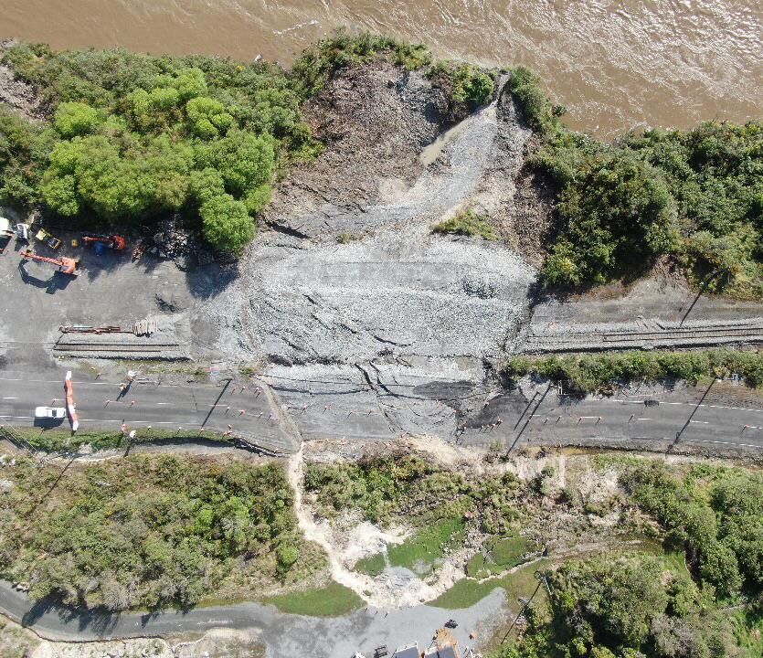
2
While the New Zealand tourism market has been seriously affected by the closing of international borders,
the RLTP has been prepared with an expectation that this sector will recover over time. It is likely that there
will be changes in the tourism experience being sought, and delivered, when tourism activity resumes.

1.3 Economic stimulus
There has been a significant amount of planned and emergency funding made available in the lead up, and
development, of this RLTP. The West Coast has been identified as a ‘surge region’ and since 2018, sectors
across the region have benefitted from investment through the Government’s Provincial Growth Fund.
Investment from the Provincial Growth Fund had a strong focus on tourism development to capitalise on
increasing visitor numbers. In March 2020 the Government released its fiscal and economic response to the
Covid-19 pandemic, asking Crown Infrastructure Partners for projects that were ‘shovel-ready’ or likely to be
ready within six months, to assist with the Country’s economic recovery. These funding injections have led to
the progress of transport projects across the region; projects that would not have been funded for many
years due to a small rating base, limited funding availability and the rising cost of maintaining and renewing
infrastructure.

                       DRAFT WEST COAST REGIONAL LAND TRANSPORT PLAN – 2021 - 2031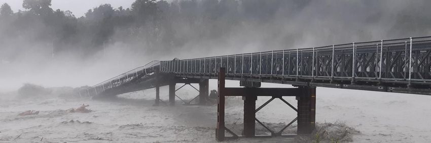
3
2. Strategic context
2.1 Our region
The transport network exists to connect people with places and allow the freight that sustains our
communities to flow. It contributes to our wellbeing as individuals, communities and as a region.
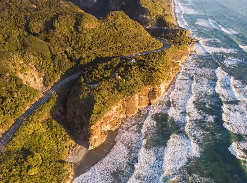
Fairly isolated from the rest of the country, the West Coast is also New Zealand’s most sparsely populated
region. Stretching some 600km from north to south, wedged between the Tasman Sea and the Southern Alps,
the natural environment and topography are key influencers of not just the economy but the transport
network too.
Tai Poutini West Coast is known for its rugged coastline, high mountains, THE WEST COAST
forests, lakes, rivers, lagoons and karst systems. People choose to visit the
CONSERVATION ESTATE
region because of this ‘untamed natural wilderness’, and its recreational
and historic attractions. Approximately one quarter of all public
conservation lands in New Zealand can be found on the West Coast A unique backdrop for
making it a key asset of the region. domestic and international
tourism, the West Coast
With yearly rainfall totals averaging between 1,746mm and 11,228mm, Conservation Estate comprises
1.912 million hectares or 84%
the West Coast is the wettest region in New Zealand. Extreme weather
of the region, including:
events, flood prone river systems, proximity to the Alpine Fault, landslips
• 5 national parks
and exposed coastal areas are hazards that regularly disrupt the transport
network. The frequency and scale of these events is anticipated to • 1 world heritage area
increase in the future further exacerbating the current issues. • 114 scenic reserves
• 19 historic reserves
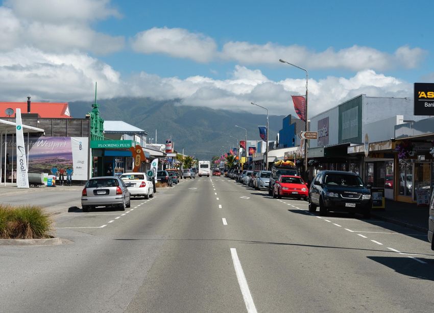
Approximately half of the West Coast population reside in the three main • 92 recreation reserves
towns of Westport, Greymouth and Hokitika. The remaining population • 45 ecological areas
are dispersed in small towns throughout the region, connected in the • 21 amenity areas
majority, by the State Highway. • 390 stewardship areas
• 5 gazetted wilderness areas
The West Coast economy is reliant on a small number of industries who in
turn, have a high dependence on the natural resources of the region. Within this, the Department of
Traditionally a mining region, the decline in this sector has seen Conservation manages:
agriculture, particularly dairy, grow. New opportunities are being sought • 1,287km of tracks
in other mineral extraction areas, horticulture and boutique sectors. • 146 huts
• 2,009 structures
The West Coast has a relatively high share of GDP from exports, 44.3% in
• 11 roadside camps
2019 compared to 27.2% nationally. Agriculture dominates exports, with
• 186km of road
dairy product manufacturing accounting for 50.4% ($412.4m) of total
exports from the region. Raw and processed goods are primarily exported
by road and rail to neighbouring regions for further distribution nationally and overseas. The local road
network is critical to connect businesses and freight hubs, rail links and the state highway network. These
links feed into the ports for export highlighting the importance of an intermodal transport network for the
extractive industry.
Over the past 10 years, the West Coast has experienced significant growth in domestic and international
tourism markets, and in some areas become particularly reliant on tourism. With 40 guest nights booked per
capita, five times higher than the national average1 (in comparison, the second highest region Otago has 26
guest nights booked per capita), the contribution of tourism to GDP is significant compared to the rest of New
Zealand. From 2012 to 2019 the tourism share of GDP in the region has more than doubled (6.7% to 14.9%),
1
Waka Kotahi Arataki Version 2 – West Coast
DRAFT WEST COAST REGIONAL LAND TRANSPORT PLAN – 2021 - 2031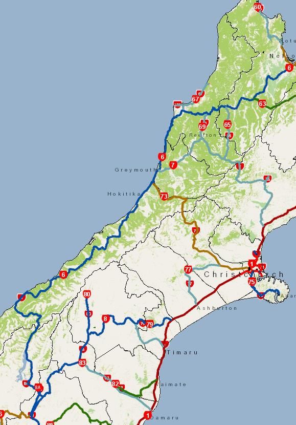
4
while absolute growth from 2012 to 2019 was 81.6% ($152m to $276m). Tourism is also a major contributor
to employment in the region, supporting 22.5% or 3,657 filled jobs.
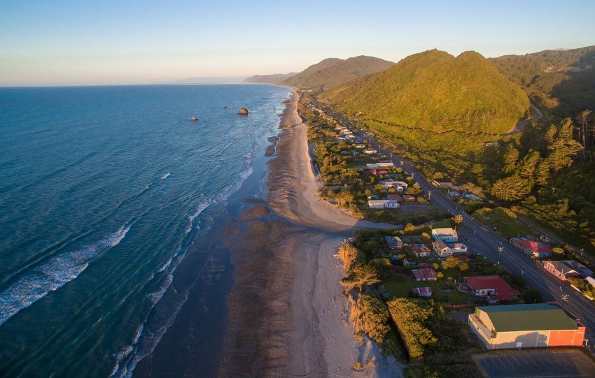
Travel along the West Coast often forms part of a larger tourist journey that includes Christchurch, Arthur’s
Pass and Queenstown and/or Nelson, Buller Gorge, Reefton and Lewis Pass. The Lonely Planet describes the
drive down the West Coast from Punakaiki to Greymouth as one of the ‘top ten coastal drives in the world’.
The West Coast Tourism Strategy was launched in 2016 along with the new Untamed Natural Wilderness
brand. A coordinated approach to promoting and developing tourism in the region was a catalyst in driving
tourism growth. Identification and marketing of six tourism icons (Oparara Arches, Punakaiki – Pancake Rocks,
Lake Brunner, Hokitika Gorge, Glacier Country, Haast world heritage area) in the region sought to diversify the
product range. Alongside these, the rich and diverse natural environment comprising the mountains, lakes,
rivers, lagoons, coastal beaches and outlooks dotted with historic settlements are major attractions to the
region.
The glaciers in Westland are the third most common reason overseas visitors give for coming to New Zealand.
Along with Lake Matheson, the Glaciers were hosting approximately 1 million visitor per annum with
international visitors made up 76 percent of visitors. The majority of visitors to the northern West Coast visit
Punakaiki, Cape Foulwind, Denniston and the Oparara Arches. Of these, the Dolomite Point walk at Punakaiki
is the most popular destination with approximately 450,000 visitors per annum.
The West Coast tourism product is completely dependent on the transport network, primarily the State
Highways, but also the local and Department of Conservation roads to travel the ‘final mile’ to access the
destination. Visitors to the region travel predominantly via self-drive vehicles as opposed to buses, as they
seek the ‘off the beaten track’ experiences and require a safe a reliable transport network as they visit the
scenic wonders of the West Coast.
Guest nights to the West Coast for the year ended September 2019 were 1,317,906, a fall of 5.8 percent
compared to the previous year. Tourism growth was strong but due to severe weather events which severed
the key transport route through South Westland and the uncertainty this caused for the industry going
forward, a decline in numbers had begun. The spread of Covid-19 around the world in February 2020, and the
closure of international borders, has put the brakes on the West Coast tourism industry, particularly in South
Westland. Tourism is not predicted to return to anything like normal until at least July 2022. Domestic tourism
INVESTING IN TOURISM
Many of the new or upgraded tourism destination and facilities, or those planned, have been funded through the Provincial Growth
Fund as a means of transitioning away from extractive industries. These projects include:
- $25.6 million to transform Punakaiki into a world class visitor destination
- $3.5 million upgrade of the Croesus Road to provide access from Blackball to the Paparoa Track (Great Walk)
- $9.36 million development of the Kawatiri Coastal trail along the coast from Charleston to Westport
- $5.7 million development and restoration of the Oparara Basin
- $17.87 million to bring the stories of Poutini Ngāi Tahu to life across the region.
Other investments include:
- Upgrade of the Hokitika Gorge track making this one of New Zealand’s best short walks.
- Upgrade and development of cycle trails in Reefton, Westport, Greymouth
- New Peak View lookout for Fox Glacier in Westland – an alternative attraction developed following the closure of the Fox Glacier
access road after a significant flood in 2019.
Each of these investments have, or will, impact the transport network; increasing traffic flows, changing travel routes or transport
modes. Future investment in the transport network will need to take this into account.
DRAFT WEST COAST REGIONAL LAND TRANSPORT PLAN – 2021 - 2031
5
provides some relief, but this is being experienced primarily in the Buller and Grey Districts, destinations
closer to bigger population centres.

2.2 Our people
The West Coast is the country’s fifth largest region by land area, but the smallest by population size. Its
resident population of 31,575 (as at the 2018 Census) saw an increase of just 249 from 2006 (0.8%). However,
the West Coast is one of the few regions in New Zealand projected to have a decline in population over the
next two decades with an estimated (medium scenario) 6% decline from 2018-43 to a population of 30,600.

Demographically, the West Coast’s population is not dissimilar to the rest of New Zealand, although it does
have a slightly smaller proportion of school age and younger children, and a slightly higher proportion of the
population of retirement age.

Mana whenua
Ngāi Tahu are the tangata whenua that hold the mana of the West Coast and further parts of the South
Island. Ngāi Tahu’s takiwa (tribal area) is the largest in New Zealand, and extends from White Bluffs/Te Parinui
o Whiti (southeast of Blenheim), Mount Mahanga, and Kahurangi Point in the North to Stewart Island and the
Subantarctic Islands in the south. Ngāi Tahu comprises 18 runanga (governance areas) corresponding to
traditional settlements.

There are two rūnanga who are the kaitiaki (guardians) of the West Coast region. These are:
- Te Rūnanga o Ngāti Waewae is the mandated representative body of Ngāti Waewae, a hapū of Ngāi Tahu.
  Their takiwā is centred on Arahura and Hokitika and extends from the north bank of the Pouerua River to
  Kahurangi and inland to the main divide. Ngāti Waewae shares the area between Hokitika and Pouerua
  with Ngāti Māhaki. Te Rūnanga o Ngāti Waewae is based at Arahura Marae, where the whare tipuna
  (meeting house) is Tuhuru, named after a great fighting chief of Poutini Ngāi Tahu.

- Te Rūnanga o Makaawhio is the mandated representative body of Ngāti Māhaki ki Makaawhio, a hapū of
  Ngāi Tahu. Their takiwā is centred at Makaawhio (Jacobs River) and Mahitahi (Bruce Bay) and extends from
  the south bank of the Hokitika River to Piopiotahi and inland to the main divide. Ngāti Māhaki share the
  area between Pouerua and Hokitika with Ngāti Waewae. Te Rūnanga o Makaawhio is based at Te Tauraka
  Waka a Māui Marae, where the whare tipuna is Kaipo, named after an ancestor of all Poutini Ngāi Tahu.

2.3 Our transport system
This section provides a high-
level overview of the key
transport systems’
contribution to the
network on the West
                                           TRAVEL TO AND FROM WORK ON THE WEST COAST
Coast. Our transport
network provides the                          Based on Census 2018:
connections communities                       65% of those in employment usually            20% of people worked from
need to live day to day. This                 used a private car or company                 home, compared to 12%
connectivity is essential for the             vehicle to get to work on the West            nationally
economic, social and cultural                 Coast
wellbeing of the West Coast.                  8% walked or jogged                           2% biked to work
Transport links can create a
vibrancy and vitality to a
community, a town or a region.

                        DRAFT WEST COAST REGIONAL LAND TRANSPORT PLAN – 2021 - 2031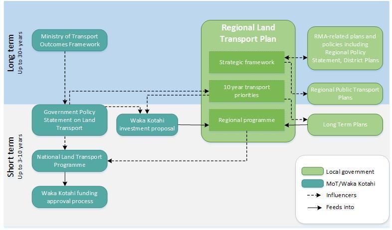
6
Road network
Despite the West Coast having less than 1 percent of New Zealand’s population, state highways within the
region account for 8% of the total length of the national state highway network, almost three times as high as
the national average. The performance of the state highway is therefore particularly important for the West
Coast.

The network of state highways and local roads, as well as a freight rail connection linking Hokitika, Greymouth
and Westport to Lyttleton, is critical for the rural-based economy, moving goods to production centres and on
to domestic and international markets. The geographically dispersed nature of primary sector industry
(mining, agriculture and forestry) requires heavy vehicles to drive on low volume roads that are narrow and
winding and often not designed with these vehicles in mind. Intermodal connections are essential to the
future of the efficient movement of freight for the region. Logs are now coming into Greymouth to be
transferred from road to rail. The inland port at Stillwater provides for the transfer of coal from truck to rail.
River ports in Greymouth and Westport currently provide little in the way of freight transport.

State Highway 6 makes up the transport spine of the network,
from Haast through to Westport, and north to Nelson. State
Highways 73 and 7 provide links to Canterbury, with the
former recognised as critical to the movement of freight for
the region.

There are two Special Purpose Roads (SPR) on the West Coast:
1. Karamea Highway (including Karamea-Kohaihai Road) in
   the Buller District
2. Haast to Jacksons Bay Road in the Westland District

Both roads are part of the national transition of SPR roads to
local road status, and subsequent change in funding from the
current 100% funding assistance rate (FAR) to the normal rate
of each local authority. Whilst a draft Special Purpose Road
(SPR) transition plan has been considered for these roads, no
agreement has been reached between Waka Kotahi and the
respective councils for a change to Local Road status, nor has
there been Council acceptance of responsibility for funding
specific activities following any transition. As such, while the
forward programme and financial assessment have been
developed on the assumption of a 1st July 2024 transition,
this is not an endorsement from the councils of Waka Kotahi’s
preferred approach. A summary of the transition plans and proposed work programmes is outlined in the
West Coast Combined Asset Management Plan.

The Department of Conservation is responsible for 186kms of roading that provide access to public
conservation land destinations, although approximately 80kms are restricted access roads. Maintenance
arrangements for the public roads have in the past been varied, with access roads to the Franz Josef and Fox
Glaciers being maintained under ad hoc arrangements. From mid-2020, Department of Conservation public
roads will be maintained through the Waka Kotahi State Highway contract for the West Coast.

Weather events have presented repeated resilience issues for the Glacier access roads, resulting in the
indefinite closure of the Fox Glacier access road and the temporary closure of the Franz Josef Glacier Access
Road. Within the 2021-24 period, the Department and Waka Kotahi will be working with stakeholders to
determine a preferred strategic approach to providing access to the Franz Josef Glacier.

                       DRAFT WEST COAST REGIONAL LAND TRANSPORT PLAN – 2021 - 2031
7
Rail
Rail, for the West Coast, is used
predominantly for freight; coal, logs
and dairy. The branch line to Hokitika
primarily caters to Westland Milk
Products, bringing raw product to the
factory and moving product out of the
region for market distribution. Lines to
Rapahoe, Westport and Ngakawau
have traditionally been used for the
movement of coal from source to
Lyttleton Port. These movements have
decreased over the past decade. South Island rail network
Loading points in Greymouth and
Stillwater enable the transfer of
product from road to rail.
The TranzAlpine passenger rail service between Christchurch and Greymouth has been described by Lonely
Planet as one of the world’s 10 most amazing rail journeys. The Government has been investing in the
TranzAlpine through the Provincial Growth Fund, recognizing the contribution the service provides to the
region bringing 82,000 visitors a year into Greymouth. It was anticipated that the investment would increase
those numbers to close to 120,000 passengers within the next decade prior to the global pandemic. There are
no commuter rail services available on the West Coast.
The rail network has the potential to contribute to reducing greenhouse gas emissions and improving
resilience and safety on interregional route to Canterbury. The ongoing physical, and economic, security of
the rail link is vital to the future of the West Coast. New product options for the future may be needed should
the export of coal via rail reduces further or ceases entirely.
Public transport
The West Coast does not have a comprehensive public transport network due to its small and dispersed
population base, although some private operators provide services where demand warrants such as for
tourism and school buses.
The Buller and Westland District Councils receive a subsidy for small (but important) programmes for taxi
services in Westport and Hokitika. Subsidised door-to-door transport services are available for people with
mobility impairments through the Total Mobility scheme. The scheme is available to people in Westport,
Greymouth and Hokitika and carries approximately 17,500 passengers annually. Eligible individuals are
entitled to discounts that give them 50% off transport fares with approved operators, up to a maximum of
$30 per trip.
Inter-regional commercial bus and coach services provide some connections between the regional towns and
urban centres in other regions. Airports at Westport and Hokitika currently provide commercial services
through Sounds Air and Air NZ respectively.
DRAFT WEST COAST REGIONAL LAND TRANSPORT PLAN – 2021 - 20318
Walking and cycling
West Coast Hero Multi-day Rides
While walking and cycling are
important transport modes for the
West Coast for day to day travel in
urban areas, they hold higher
prominence as regional attractions
with the many walking, tramping
and cycle trails on offer. The
network of trails is being enjoyed
by locals and visitors alike, making
the West Coast wilderness more
accessible to riders of all abilities
and removing cyclists from roads,
particularly state highways. This
shift to adopting more active
modes of transport through
walking and cycling, is a critical
component to the revitalisation of areas such as Westport which has received funding to redevelop the
waterfront along the riverbank, in addition to the Kawatiri Coastal trail. Gaps remain in the regional network.
Developments such as these create new destinations, but investment is required to ensure that safe
connections to access these are provided. Due to the trails being ‘free’ to use, funding the maintenance and
operation of the established trails now and into the future is challenging.
There are some dedicated on-road shared cycle lanes primarily in Greymouth, including along the main
commuter route into Greymouth along High Street, Shakespeare Street, Greymouth to Boddytown via
Marsden Road, as well as Rutherglen Road from State Highway 6 to the tourism attraction Shantytown.
Walking facilities were a focus of the District Councils 2019 community survey with themes emerging around
a need for improved footpath condition, and provision of better walking and cycling infrastructure in urban
areas.
Cycling technology continues to evolve and is allowing cycling to be more accessible to more people. People
are able to travel further, faster and to more places on e-bikes than traditional cycles. This has, and will
continue to, extend the commute options for people who chose to change modes, as well as opening up
recreational cycling routes to a wider range of the population.
Airports
There are limited air services via Westport and Hokitika. Sounds Air operates daily return services between
Westport and Wellington. Air New Zealand provides services between Hokitika and Christchurch. The airport
at Greymouth caters to private planes and the hospital transfer service. Located at the Greymouth
aerodrome site is the helicopter search and rescue base, land search and rescue base and St Johns
Ambulance – all adjacent to Grey Base Hospital.
A $1.24 million investment from the Provincial Growth Fund (PGF) will soon improve terminal congestion
problems and make room for shops and café businesses at the Hokitika airport. These improvements will
make the airport facility fit for purpose. The PGF also invested $2.074M to rebuild 700m of an 850m seawall
adjacent to the Westport airport runway after its collapse due to the impact of Cyclone Fehi.
Ports
The West Coast is the only region to be located more than 150km from a major sea port. The ports of the
West Coast are strategically important assets that can create resilience against natural disaster, provide for
DRAFT WEST COAST REGIONAL LAND TRANSPORT PLAN – 2021 - 20319
commercial viability and enable economic growth. The West Coast has three small ports located at Westport,
Greymouth and Jacksons Bay.
The ports of Westport and Greymouth are river and estuary ports, each having a bar which from time to time
makes access problematic. They have not enjoyed the access to international freighters which the deeper
ports like Lyttleton, Port Chalmers, Wellington etc. have.
All three West Coast ports are strongly focused around the fishing sector. Although the fishing sector is a
significant economic contributor to the West Coast economy, the sector is relatively small in terms of cargo
volumes and can only pay for its specific infrastructure (at best). A base cargo is required to turnaround the
fortunes of the West Coast ports. The West Coast has a number of mineral, quality timber and agricultural
products with strong export markets. The ocean off the West Coast is the location of a significant Fisheries
Management Area.
Some larger West Coast businesses have considered utilising the ports as part of a contingency plan should
major transport occur on the road or rail network. However, due to the perceived condition of the assets and
their future, the ports have struggled to become a robust alternative.
2.4 Transport and land use integration
One of the most significant drivers of demand for land transport is population growth and land use change.
The West Coast has a relatively stable population and is unlikely to face the same level of growth experienced
in other regions. There is limited ability to change land use on a large scale in the region due to land
administer by the Department of Conservation being the primary land use. Transport systems and land use
are closely linked.
Land use change cannot just be assessed on the immediate roads or connections involved. The effects on the
wider transport network must be considered to identify where potential future infrastructure may be
required to service any additional load. This responsibility rests mainly with territorial authorities who control
land use in their district plans. The District Plans will soon be replaced with a combined District Plan - Te Tai o
Poutini Plan. Te Tai o Poutini Plan will look at spatial planning across the region as well as considering issues
such as managed retreat.
2.5 Inter-regional connections
The West Coast is heavily reliant on the transport network of the entire South Island, as well as the Cook
Strait ferry which provides the vital road and rail link for people and freight to the North Island. Manufactured
and retail goods are typically delivered from distribution centres in Christchurch on a daily basis. A reliable
road network to maintain these links is critical to the health and wellbeing of our communities, underpins the
regional economy and provides for essential goods and services.
The ‘tourist loop’; State Highway 73 from Christchurch to the West Coast, down State Highway 6 through
South Westland to Southland and Central Otago, and then State Highway 1 back to Christchurch, highlights
the cross-boundary activity and illustrates that for tourists, there really are no regional borders.
There is ongoing concern around the movement of vulnerable road users, particularly cyclists and
motorcyclists, along inter-regional State Highways, particularly as they travel within a high-speed
environment. For example, due to a lack of alternative routes, some State Highways have been classified as
NZ Cycle Trail ‘Heartland Rides’ (State Highway 6 between Hokitika and Hawea) despite not meeting the
prerequisite of being ‘quiet, back-country roads’.
DRAFT WEST COAST REGIONAL LAND TRANSPORT PLAN – 2021 - 203110
2.5 Future opportunities
There are a number of plans and strategies that have been developed or are under development that will
impact the transport network across the region.
Te Tai o Poutini Plan (West Coast combined District Plan)
Every district in New Zealand must have a working plan identifying community values and how to achieve
them by managing where and how services are delivered, and how resources are used. In 2015 some
members of the West Coast community asked the Local Government Commission to look at options for
streamlining the local Councils. The outcome, the statutory obligations for preparing district plans has been
transferred to the West Coast Regional Council overseen by Joint Committee.
Te Tai o Poutini Plan will include a specific section to address transport matters, as well as broader
infrastructure provisions. The provisions, including rules, will cover roading, rail, airports, heliports and ports.
Nationally significant infrastructure, such as the state highway and rail network, will be recognised, as well as
other transport infrastructure. Designations will also be updated through this plan process. Given the critical
nature of transport networks to everyday life, this Plan will have a significant influence on addressing matters
associated with hazards and risks, subdivision, zones and development areas.
West Coast Economic Development Strategy 2018-2025
- Growing the economic benefits from visitors and supporting the tourist industry, through enhanced visitor
experiences, corridor improvements and increased visitor information
- Support will continue for regional walking and cycling trails where there are opportunities to grow tourism
and support increased expenditure from visitors.
Securing the future of the West Coast ports
The West Coast ports of Westport, Greymouth and Jackson Bay are making losses following a decline in
export cargoes, the most recent example being the closure of Holcim at Cape Foulwind. Assets of all three
DRAFT WEST COAST REGIONAL LAND TRANSPORT PLAN – 2021 - 203111
ports are in poor condition reflecting their financial performance and low cargo volumes. There is little
confidence that the ports can recover to become strong growth businesses.
Development West Coast commissioned a feasibility study to determine the best way forward for the three
ports. The study identified several executable strategies categorized into three components; protect,
optimise, grow. The Provincial Growth Fund has provided funding of $8M for new fishing jetties and berths
for Westport and Greymouth, and an additional $3.1M for Westport for port infrastructure.
The future of the West Coast ports is closely linked to what happens with projects that create bulk product
that requires transportation, for example mineral sand and either the export of the raw product to
Christchurch for processing or processing this on the West Coast and exporting it through a West Coast port.
Franz Josef Master Plan
The Franz Josef Master Plan is continuing to be developed. Westland District Council will be budgeting for this
development in the 2021-31 Long Term Plan. The most appropriate long-term floodplain management
solution for the Waiho River is also currently being decided.
West Coast Cycle Trail Review
The West Coast Cycle Trail Review presents the tools to better connect, integrate and fund the network of
trails in the region. There is an existing network of trails which are all at various stages of maturity with
projects in the planning, funding application or construction phases. The intent is to create distinct clusters of
cycle trails within each of the districts to provide opportunities for streamlining current trail operations.
Clustered cycling developments are attractive for tourists and present opportunities for additional bed nights
and increased spending.
Tourism Destination Management Plan
Pre-Covid, the West Coast had a steadily increasing tourism market by way of visitor numbers, GDP and total
jobs. As part of the 2020 recovery package, the Regional Tourism Organisation received funding which
included resourcing for developing a Destination Management Strategy for the West Coast. The Destination
Management Strategy includes an integrated approach to marketing and promotion, visitor experience and
resource management. The Plan will have sixteen components including access, amenities, services and
infrastructure.
Pounamu Pathway
The Provincial Growth Fund has invested $17.87 million into the Te Ara Pounamu Pathway project to support
the rollout of state-of-the-art innovative digital technology to tell the West Coast’s unique cultural and
historical stories, for the first time, to Aotearoa New Zealand and the world. Pounamu (greenstone) is unique
to the West Coast. Tourists will be able to follow the linked pathway, visiting the four new visitor experience
centres in separate locations across the region, as they learn more about the history of Maori across the West
Coast. The first hub is to be built in Haast and completed in 2021, with all four expected to be completed by
2023.
Tohu Whenua
Tohu Whenua is a visitor programme that connects New Zealanders with their heritage and enhances their
sense of national identity by promoting significant historical and cultural sites. The programme is in
partnership with the Ministry of Culture and Heritage, Heritage New Zealand Pouhere Taonga and has the
goal to establish a credible and connected network of heritage sites suitable for visitors. Tohu Whenua on
public conservation lands currently include Denniston and the Brunner Mine Site. Waiuta is proposed to be
added late 2020.
DRAFT WEST COAST REGIONAL LAND TRANSPORT PLAN – 2021 - 203112
3. Policy Context
A number of statutes and policy and planning documents provide the legislative and policy context for land
transport planning and investment at the national, regional and local level. These have informed the
development of this Regional Land Transport Plan.
Core statutes
The Land Transport Management Act (LTMA) 2003 is the principal statute guiding land transport planning and funding in New Zealand. The
purpose of the Act is to contribute to the aim of achieving an affordable, integrated, safe, responsive and sustainable land transport system.
The LTMA sets out the core requirements of regional land transport plans and regional public transport plans for every region.
The Resource Management Act (RMA) 1991 which aims to promote the sustainable management of natural and physical resources and
provides the statutory framework for land use planning and the development of regional policy statements, regional plans and district plans.
Land use planning can have a significant influence on travel choice and transport network demand. Likewise, transport network investment
can shape land patterns within a region. The West Coast Regional transport Committee must take the West Coast Regional Policy Statement
into account when developing the West Coast RLTP.
The Local Government Act (LGA) 2002 guides local government planning and the way councils carry out their functions. It includes
provisions guiding the development of council long-term plans and infrastructure strategies, where the local funding share for the transport
network investment is identified alongside other local investment priorities. The LGA also sets out consultation principles that are relevant
for development of regional land transport plans.
The Climate Change Response Act 2002, which was amended by the Climate Change Response (Zero Carbon) Amendment Bill in 2019. Now
provides a framework for New Zealand to develop and implement climate change policies that contribute to global efforts under the Paris
Agreement to limit the global average temperature increase to 1.5 degrees Celsius above pre-industrial levels. Key provisions include setting
a target to reduce net carbon emissions to zero by 2050. The transport sector will have a key role in contributing to achieving this target
though more so in urban areas, and more populated regions than the West Coast.
Context of other National Policy
In 2018, the Ministry of Transport worked with other government agencies to develop a Transport Outcomes Framework for the transport
system. This framework takes a strategic, long-term and integrated approach to transport and makes clear what government is aiming to
achieve through the transport system in the long term. It is an enduring document meant to last beyond government of the day change. The
five outcomes are:
- Inclusive access – enabling all people to participate in society through access to social and economic opportunities, such as work,
education and healthcare.
- Healthy and safe people – protecting people from transport-related injuries and harmful pollution and making active travel an attractive
option.
- Environmental sustainability – transitioning to bet zero carbon emissions, and maintaining or improving biodiversity, water quality and air
quality.
- Resilience and security – minimizing and managing the risks from natural and human-made hazards, anticipating and adapting to emerging
threats, and recovering effectively from disruptive events.
- Economic prosperity – encouraging economic activity via local, regional and international connections, with efficient movements of people
and products.
All of these outcomes are inter-related. To make a positive contribution across the five outcomes, the transport system also needs to be
integrated with land use planning, urban development and regional development strategies.
The LTMA requires the Minister of Transport to issue the Government Policy Statement on Land Transport (GPS) every three years. The GPS
sets out the government’s priorities for expenditure from the National Land Transport Fund over a 10-year period, and how funding should
be allocated. Regional Land Transport plans must be consistent with the GPS, and Waka Kotahi must give effect to it with regards to land
transport planning and funding. The 2021 GPS strategic priorities are safety, better travel options, improving
RLTP contains the following direction that is consistent with the GPS:
- Improvements to freight routes that improve network efficiency as well as resilience and reliability.
- Measures to improve road safety and reduce deaths and serious injuries.
DRAFT WEST COAST REGIONAL LAND TRANSPORT PLAN – 2021 - 203113
The Road to Zero: NZ Road Safety Strategy 2020 – 2030, articulates the Government’s vision of ‘a New Zealand where no one is killed or
seriously injured in road crashes’, guiding principles for design of the road network and road safety decisions, as well as targets and
outcomes for 2030. It sets out the five areas of focus for the next decade:
- Infrastructure improvements and speed management
- Vehicle safety
- Work-related road safety
- Road user choices
- System management
This RLTP includes a headline target that is aligned with the NZ Road to Zero Safety target of a reduction in deaths and serious deaths and
injuries at a regional level.
The National Policy Statement on Urban Development 2020 (NPS-UD) replaces the NPS-UDC 2016. The NPS-UD ensures New Zealand’s
towns and cities are well-functioning urban environments that meet the changing needs of our diverse communities and removes barriers to
development in locations that have good access to existing services, public transport networks and infrastructure.
The New Zealand Energy Efficiency and Conservation Strategy (NZEECS) 2017-2022 sets the overarching direction for government and
specific actions for the promotion of energy efficiency and renewable sources of energy. The current NZEECS includes ‘Efficient and low-
emissions transport’ as one of three priority areas, with an associated target for electric vehicles to make up two percent of the vehicle fleet
by the end of 2021. Efficient freight movements are recognised in the strategy and this has been taken into account in developing the
policies and priorities in the West Coast RLTP as required by the LTMA.
Arataki is Waka Kotahi’s 10-year view of what is needed to deliver on the government’s current priorities and long-term objectives for the
land transport system. Arataki outlines the context for change, the step changes in existing responses that it believes are needed, and the
levers the Transport Agency will use, in partnership with others, to shape change. It includes national, pan-regional and regional summaries.
Arataki Version Two provided an update in relation to Covid-19 impacts.
Key insights were identified for the West Coast and these have informed the development of this RLTP. Areas of high focus for the West
Coast include:
- Ensuring the state highway network is well maintained, resilient and safe
- Addressing the regions relatively poor safety record
- Ensuring key tourism and freight routes are safe and resilient.
Other National and Regional Plans
There are several other national plans which provide important context for the development of RLTPs.
Waka Kotahi’s, Keeping Cities Moving: National Mode Shift Plan sets out national objectives and programmes to increase the share of travel
by public transport, walking and cycling by shaping urban form, making shared and active modes more attractive, and influencing travel
demand and transport choice.
The Ministry of Transport’s draft New Zealand Rail Plan outlines the Government’s long-term vision and priorities for New Zealand’s national
rail network, for both freight and passenger networks. The Land Transport (Rail) Legislation Bill will amend the LTMA to bring about the
proposed rail policy framework for rail.
The land transport system is currently classified using a single system regardless of who the road controlling authority is. The One Network
Road Classification (ONRC) classifies the road transport network on vehicle-based traffic volumes, strategic corridors and place of
significance such as ports, airports and hospitals. ONRC reflects current travel demand and how communities are interconnected.
The West Coast Regional Policy Statement (RPS) sets the regional direction for future management of natural and physical resources,
providing the foundation for the development of regional and district plans. The RPS includes policies relating to managing natural hazards
and climate change.
The West Coast Regional Public Transport Plan 2021-2031 (RPTP) sets out the objectives and policies that will guide the provision of public
transport for the West Coast. The focus of the RPTP is on ensuring the provision of the Total Mobility Scheme for those who are transport
disadvantage and impaired.
DRAFT WEST COAST REGIONAL LAND TRANSPORT PLAN – 2021 - 203114
4. Strategic framework
The Land Transport Management Act 2003 seeks an effective, efficient and safe land transport
system.
4.1 Strategic objectives
The following diagram shows the relationship between the Government’s transport outcomes and
this RLTP’s strategic framework.
Ministry of Transport’s Outcomes Framework
THE PURPOSE OF THE TRANSPORT SYSTEM IS TO IMPROVE PEOPLE’S WELLBEING, AND THE LIVABILITY OF PLACES
OUTCOME 1 OUTCOME 2 OUTCOME 3 OUTCOME 4 OUTCOME 5
Inclusive access Healthy and safe Environmental Resilience and Economic prosperity
people sustainability security
Regional Land Transport Plan – 30-year vision
A SAFE, RESILIENT AND CONNECTED MULTI-MODAL TRANSPORT NETWORK WHICH ENABLES THE WEST COAST TO THRIVE
Strategic objectives – we will deliver our vision and targets through…
Objective 1 Objective 4
RESILIENCE
Objective 2 Objective 3 CONNECTIVITY
A transport network that can
ASSET CONDITION SAFETY A multi-modal transport
better cope with unknown
A transport network that is fit A transport system that is network that enables all
Objective
stresses, 1
natural disasters
for purpose safe for all users users to meet their
and the impact of climate
economic, social and
change
cultural needs
Headline Targets
Resilience Safety Connectivity
Asset condition Increase in active modes,
Reduced number of, and Reduction in deaths and
Reduction of assets not more walking and cycling
duration of, closures on serious injuries on West
fit for purpose activity
the strategic road network Coast roads
DRAFT WEST COAST REGIONAL LAND TRANSPORT PLAN – 2021 - 203115
4.2 The regional vision – ten-year transport priorities
Having a safe, resilient and connected multi-modal transport network which enables the West Coast to
thrive is the vision set by the Regional Transport Committee (RTC) recognizing the critical nature of
the transport network to the economic and social wellbeing of our communities. The RTC has
identified the most urgent and significant issues for the next ten years if we are to achieve this vision.
The key problems we need to address within the next ten years are:
- A transportation network that is increasingly vulnerable to adverse events, resulting in economic
and social disruption
- Aging and insufficient infrastructure (such as HPMV restricted bridges, unsealed roads, constrained
pavement widths), combined with the changing needs of transport users over time (e.g. changes in
the freight task), means there are pockets of infrastructure across the region that are no longer fit
for purpose
- The natural topography and dispersed settlement pattern contribute toward some challenging
driving conditions. This combined with high proportion of visiting drivers who are unfamiliar with
the local environment, drivers with poor behaviours (such as travelling at inappropriate speeds,
under the influence of alcohol or drugs, or by motorcycle) contribute to crashes that cause death
or serious injury.
The main benefits of addressing these problems are:
- Improved network reliability to better respond to the effects of natural hazards and climate
change
- A transport network that is fit for purpose efficiently connecting users to their destinations
- A safer transport network and system.
To achieve this vision, the RTC has established long term strategic objectives, short term (10 year)
investment priorities, and agreed a policy framework that will help guide and deliver this Regional
Land Transport Plan.
In response to these problems and investment benefits, the West Coast’s ten-year transport
investment priorities are:
- Adapting our transport network to reduce the impact of adverse events
- Investing in our transport network so it is fit for purpose
- Implementing safer systems (Road to Zero)
- Connecting our networks and users
In addition to addressing these problems, five additional opportunities the RTC will be pursuing are:
1. Taking a South Island wide approach to transport in conjunction with the South Island RTC Chairs
Group
2. Advocating for better mode integration and mode shift when opportunities present themselves
3. Supporting tourism and the regional dispersal of tourism benefits
4. Encouraging the creation of a network of cycle rides, and cycling facilities, throughout and
between the regions
5. Leveraging opportunities to access funding through the Covid-19 recovery funding streams.
The benefits of realising these opportunities include:
- Improved performance and capability of the transport network and network resilience
- Regional economic development, productivity and connectivity
- Greater value for money.
DRAFT WEST COAST REGIONAL LAND TRANSPORT PLAN – 2021 - 203116
A transport network that can better cope with unknown stresses, natural
Objective 1
disasters and the impacts of climate change
Target Reduced number of, and duration of, closures on the strategic road network
The West Coast is known for its high rainfall. Recent major storm events have highlighted numerous
weaknesses within the West Coast transport network. With many of its townships located alongside
rivers, flooding is not uncommon, though in many cases this is now mitigated through protection
works. However, severe storms can have significant impacts on the road and rail networks resulting in
flooding, erosion, slips, rockfall, culvert blowouts, loss of bridge approaches, or the bridges
themselves. Much of the West Coast is reliant on the ‘spine’ formed by the state highways while
district roads serving local communities are interconnected through the state highway network. The
impact of network closures on customers and communities, and in particular the tourist and freight
sectors, is worsened by this lack of alternative routes and extreme detour lengths.
The biggest challenge with storm events is trying to anticipate what areas may be hardest hit. While
flooding rivers can often be modelled, landslides and major rainfall ‘cloudburst’ events are impossible
to predict and will continue to be an activity Road Controlling Authorities can only react to. Coastal
erosion (while largely cyclic) is currently causing problems for portions of the West Coast network.
Warming seas and rising sea levels will only exacerbate this. Seismic risk is also above average
because of proximity to the Alpine Fault.
Road network closures isolate the West Coast from neighbouring regions, communities from each
other, and disrupt visitor access to key destinations. Many residents live in small rural communities or
on farms and lifestyle blocks and are reliant on private vehicles and the local road network for access
to food, jobs, healthcare and education. The West Coast is increasingly reliant on the transport
networks to adjoining regions for the delivery of just in time goods, export of goods to market as well
as day to day living.
An example of a particularly vulnerable part of the network is SH6 at the Waiho River (Franz
Josef). The West Coast Regional Council is investigating a number of options to mitigate flooding of
this river at the township, some of which may involve the realignment of State highway 6. There are
currently no decisions or plans to realign the state highway in this RLTP. However, the Waka Kotahi
programme does contain provision for investigation and will work with partners on a long-term
solution.
Breaks in the network have substantial impacts on the economic, social and cultural wellbeing of our
communities. Changes in climate, with an increasing number, and severity, of adverse weather
events, as well as sea level rise, will continue to significantly affect our communities.
DRAFT WEST COAST REGIONAL LAND TRANSPORT PLAN – 2021 - 2031You can also read