Street & Highway Section - Janesville Area 2015-2050 Long Range Transportation Plan - City of Janesville
←
→
Page content transcription
If your browser does not render page correctly, please read the page content below
Janesville Area
2015-2050 Long Range Transportation Plan

Street & Highway Section
Janesville Area Metropolitan Planning Organization

CONTENTS
LIST OF FIGURES..................................................................................................................................................... II
LIST OF TABLES ...................................................................................................................................................... II
1.       INTRODUCTION AND PURPOSE..................................................................................................................... 4
2.       GOAL AND OBJECTIVES ................................................................................................................................. 5
3.       EXISTING CONDITIONS.................................................................................................................................. 6
     MILEAGE OF THE SYSTEM ..........................................................................................................................................6
     CLASSIFICATION SYSTEM .........................................................................................................................................6
     CITY OF JANESVILLE STREET STANDARDS ..............................................................................................................16
        Narrow Street Standards....................................................................................................................................19
        Safety Conversions .............................................................................................................................................20
     CITY OF MILTON STREET STANDARDS ...................................................................................................................21
     BIKE LANE STANDARDS ...........................................................................................................................................22
        Rural Areas .........................................................................................................................................................22
        Urban Areas .......................................................................................................................................................23
     CURRENT TRANSPORTATION ISSUES ............................................................................................................................24
        Congestion .........................................................................................................................................................24
        Rail Transportation ............................................................................................................................................24
        Parking ...............................................................................................................................................................25
4.       TRAVEL DEMAND 2050 ............................................................................................................................... 28
     CONNECTED AND AUTONOMOUS VEHICLES.......................................................................................................................29
     BACKGROUND & MODEL INPUTS ....................................................................................................................................30
        Traffic Volumes ..................................................................................................................................................30
        Trip Purpose .......................................................................................................................................................30
        Socioeconomic Data ...........................................................................................................................................30
        Level-of-Service ..................................................................................................................................................32
     THE MODEL ................................................................................................................................................................37
        Study Area Boundary..........................................................................................................................................37
        Existing Network & Deficiencies .........................................................................................................................37
        No Build 2050 with Committed Projects ............................................................................................................38
5.       PROPOSED STREET AND HIGHWAY FACILITIES ............................................................................................ 49
     ENVIRONMENTAL CONSULTATION ...................................................................................................................................49
     SIGNIFICANT COMMITTED PROJECTS ..............................................................................................................................49
     RECOMMENDED PROJECTS ............................................................................................................................................52
        Planned ..............................................................................................................................................................52
        Proposed or Potential Projects ...........................................................................................................................57
     PROJECTS UNDER STUDY ...............................................................................................................................................60
6.       FINANCIAL PLAN ......................................................................................................................................... 66
     AVAILABLE FUNDING SOURCES .............................................................................................................................66
     AVAILABLE FEDERAL AND STATE FUNDING...........................................................................................................68
     SUMMARY OF LONG-RANGE NEEDS AND FUNDING.............................................................................................70
     COSTS........................................................................................................................................................................70
        Real Estate Acquisition .......................................................................................................................................70
     FISCAL CONSTRAINT .....................................................................................................................................................70

Streets & Highways
2015-2050 Janesville Area Long Range Transportation                                                                                                                                i
Janesville Area Metropolitan Planning Organization

     COST VS. REVENUE ANALYSIS .......................................................................................................................................... 72

7.       SYSTEM PERFORMANCE ............................................................................................................................. 77
        Economic Vitality ................................................................................................................................................77
        System Preservation ...........................................................................................................................................77
        Efficient Management and Operations ..............................................................................................................82
        Safety .................................................................................................................................................................83
        Security ...............................................................................................................................................................83
        Accessibility and Mobility ...................................................................................................................................83
        Integration & Connectivity of the System ..........................................................................................................84
        Protect & Enhance the Environment ..................................................................................................................84
     PERFORMANCE TARGETS AND INDICATORS........................................................................................................................84
REFERENCES......................................................................................................................................................... 86

LIST OF FIGURES
FIGURE 1: URBAN AND RURAL FUNCTIONAL CLASSIFICATION MAP .............................................................................14
FIGURE 2: URBAN CROSS SECTION DIMENSIONS ..........................................................................................................24
FIGURE 3: CITY OF JANESVILLE DOWNTOWN PARKING INVENTORY .............................................................................26
FIGURE 4: MODELED PROJECTS.....................................................................................................................................43
FIGURE 5: JANESVILLE AREA BASE 2010 LEVEL OF SERVICE ..........................................................................................44
FIGURE 6: JANESVILLE AREA NO-BUILD 2050 LEVEL OF SERVICE ..................................................................................45
FIGURE 7: JANESVILLE AREA LRTP PACKAGE 1 2050 LEVEL OF SERVICE .......................................................................46
FIGURE 8: JANESVILLE AREA LRTP PACKAGE 2 2050 LEVEL OF SERVICE .......................................................................47
FIGURE 9: JANESVILLE AREA LRTP PACKAGE 3 2050 LEVEL OF SERVICE .......................................................................48
FIGURE 10: RECOMMENDED STREET & HIGHWAY PROJECTS .......................................................................................59
FIGURE 11: FIVE POINTS INTERSECTION ........................................................................................................................61
FIGURE 12: ARISE CATALYST SITE 3 ................................................................................................................................62
FIGURE 13: PROJECTS RECOMMENDED FOR STUDY OR FUTURE CONSIDERATION ......................................................65
FIGURE 14: JANESVILLE MAINTENANCE MATERIAL COST 2006-2015 ...........................................................................73
FIGURE 15: MILTON MAINTENANCE MATERIAL COST 2002-2011 .................................................................................74
FIGURE 16: CITY OF JANESVILLE ROAD CONDITIONS .....................................................................................................78
FIGURE 17: CITY OF MILTON ROAD CONDITIONS .........................................................................................................78
FIGURE 18:ROCK COUNTY ROAD CONDITIONS 2015 .....................................................................................................79
FIGURE 19:LA PRAIRIE TOWNSHIP ROAD CONDITIONS 2015 ........................................................................................79
FIGURE 20: ROCK TOWNSHIP ROAD CONDITIONS 2015 ...............................................................................................80
FIGURE 21: JANESVILLE TOWNSHIP ROAD CONDITIONS 2015......................................................................................80
FIGURE 22: HARMONY TOWNSHIP ROAD CONDITIONS 2015 ......................................................................................81
FIGURE 23: MPO AUTOMOBILE CRASHES 1995-2015 ...................................................................................................83

LIST OF TABLES
TABLE 1: JURISDICTIONAL MILES ....................................................................................................................................6
TABLE 2: FUNCTIONAL CLASSIFICATION ..........................................................................................................................7
TABLE 3: RURAL ARTERIAL ROAD CLASSIFICATION .........................................................................................................8
TABLE 4: RURAL COLLECTOR ROAD CLASSIFICATIONS ....................................................................................................8
TABLE 5: RURAL LOCAL ROAD CLASSIFICATION ..............................................................................................................9
TABLE 6: URBAN PRINCIPLE ARTERIAL FUNCTIONAL CLASSIFICATION..........................................................................11
TABLE 7: URBAN MINOR ARTERIAL FUNCTIONAL CLASSIFICATION ..............................................................................12
TABLE 8: URBAN LOCAL CLASSIFICATION CRITERIA ......................................................................................................12
TABLE 9: CLASSIFICATION OF MPO PLANNING AREA ....................................................................................................15

Streets & Highways
2015-2050 Janesville Area Long Range Transportation                                                                                                                             ii
Janesville Area Metropolitan Planning Organization

TABLE 10: CITY OF JANESVILLE GENERAL STREET STANDARDS .....................................................................................17
TABLE 11: GENERAL STREET STANDARDS ......................................................................................................................18
TABLE 12: MILTON'S STREET STANDARDS .....................................................................................................................21
TABLE 13: RURAL STATE HIGHWAY BIKE LANE WIDTHS ................................................................................................22
TABLE 14: URBAN ROADWAY BIKE LANE WIDTHS .........................................................................................................23
TABLE 15: MPO POPULATION 1980 - 2050 ...................................................................................................................31
TABLE 16: MPO HOUSEHOLDS 1990-2050 ....................................................................................................................31
TABLE 17: LEVEL-OF-SERVICE ........................................................................................................................................32
TABLE 18: LEVEL-OF-SERVICE THRESHOLDS ..................................................................................................................33
TABLE 19: 2010 BASE LEVEL OF SERVICE DEFICIENCIES ................................................................................................38
TABLE 20: NO BUILD 2050 TRAFFIC MODEL WITH COMMITTED PROJECTS ..................................................................39
TABLE 21: NO BUILD 2050 LEVEL OF SERVICE DEFICIENCIES .........................................................................................39
TABLE 22: PACKAGE 1 TRAFFIC MODEL WITH COMMITTED AND RECOMMENDED PROJECTS.....................................40
TABLE 23: PACKAGE 2 WITH COMMITTED AND RECOMMENDED PROJECTS ...............................................................41
TABLE 24: PACKAGE 3 - FULL BUILD/ALL PROJECTS ......................................................................................................42
TABLE 25: SIGNIFICANT COMMITTED PROJECTS ...........................................................................................................50
TABLE 26: PLANNED PROJECTS ......................................................................................................................................53
TABLE 27: PROPOSED OR POTENTIAL PROJECTS ...........................................................................................................57
TABLE 28: PROJECTS RECOMMENDED FOR STUDY OR FUTURE CONSIDERATION ........................................................60
TABLE 29: JANESVILLE AREA MPO REVENUE ESTIMATES FOR 2015-2050 (1,000’S) ....................................................69
TABLE 30: ANTICIPATED FUNDING AND NEED ..............................................................................................................71
TABLE 31: PASER RATING AND CONDITION ..................................................................................................................77
TABLE 32: JANESVILLE AREA BRIDGE SUFFICIENCY 2002-2014 .....................................................................................82
TABLE 33: AUTOMOBILE CRASHES 1995-2015...............................................................................................................83
TABLE 34: PERFORMANCE TARGETS AND INDICATORS ................................................................................................84

Streets & Highways
2015-2050 Janesville Area Long Range Transportation                                                                                                               iii

Janesville Area Metropolitan Planning Organization

1. INTRODUCTION AND PURPOSE
The Streets and Highways section of the Janesville Area 2015-2050 Long Range Transportation Plan
(LRTP) is an update to the most recent plan, the 2005-2035 Long Range Transportation Plan. In an
attempt to support and maintain the highest possible level of personal mobility, the Streets and
Highways section evaluates the existing traffic circulation system, analyzes the street systems current
and projected deficiencies, and identifies short and long-range improvement projects.

This section not only identifies projects anticipating state and federal funding, it also identifies local
street connections consistent with area land use plans. While these local connections are likely to be
funded by local sources, and therefore not included in the fiscally constrained tables in the Plan, they
represent important connections for the overall transportation system.

Streets & Highways
2015-2050 Janesville Area Long Range Transportation Plan                                           4
Janesville Area Metropolitan Planning Organization

2. GOAL AND OBJECTIVES
The goal and objectives for highway planning in the Janesville Planning Area coincide with the goal
and objectives listed in the introduction. The objectives specifically pertaining to highway
transportation are summarized below:

Goal:       To develop and maintain an increasingly energy efficient transportation system which
            includes and integrates all modes of travel and provides for the safe and effective movement
            of people and goods, while optimizing the financial resources of the community.

Objective: By utilizing existing transportation facilities and services to their full potential.

Objective: By providing expanded facilities and services in accordance with the present and future
           demand to accommodate travel by auto, truck, bus, air, rail, bicycle, and foot with the
           intent of creating a balanced, coordinated, and efficient transportation system.

Objective: By properly maintaining and preserving the existing transportation system in order to
           increase safety and maximize the life of the investment.

Objective: By minimizing the loss and damage to persons and property due to transportation related
           crashes.

Objective: By developing and implementing programs which would lessen peak hour traffic
           congestion.

Objective: By reducing injuries and fatalities in all transportation modes.

Objective: By providing adequate intermodal connections within the transportation system.

Objective: By supporting the agricultural economy through the protection of agricultural lands, while
           maintaining an adequate road network to transport product to market.

Objective: By designing future street and highway improvements which are compatible with existing
           land uses, and which complement the land use plan.

Streets & Highways
2015-2050 Janesville Area Long Range Transportation Plan                                            5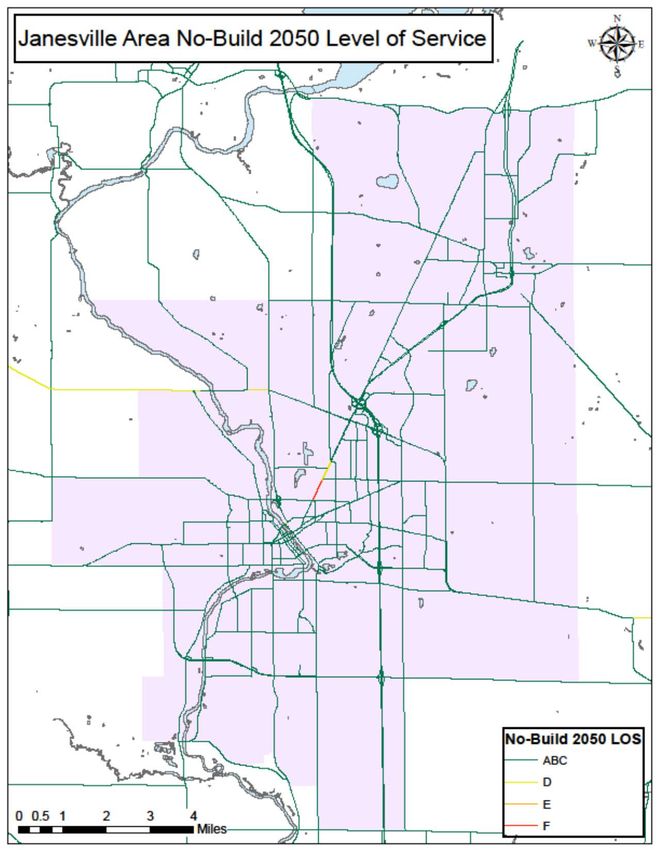
Janesville Area Metropolitan Planning Organization
3. EXISTING CONDITIONS
MILEAGE OF THE SYSTEM
Each of the MPO member jurisdictions has responsibility for the construction and upkeep of streets
and highways mileage within their respective jurisdiction. Some mileage of the system is maintained
through coordination of multiple jurisdictions. For example, the City of Janesville performs minor
maintenance of state connecting highways but the State of Wisconsin is responsible for major
rehabilitation and reconstruction.
There are approximately 720 miles of roadway within the MPO boundary but only the cities of
Janesville and Milton and the Town of Harmony are completely contained within the planning
boundary. All of the other participant jurisdictions maintain mileage both inside and outside the MPO
boundary. Many of the transportation issues described in this Plan, such as maintenance and funding,
go beyond the MPO boundary. Several available data measures for tracking transportation
performance are at the whole jurisdiction level for Rock County and the townships. Table 1 shows the
total number of miles each MPO member jurisdiction is responsible for.
Table 1: JURISDICTIONAL MILES
City of Janesville 332
City of Milton 32
Town of Harmony 49
Town of Janesville 50
Town of LaPrairie 43
Town of Milton 51
Town of Rock 51
Rock County 212
Total 821
Source: WisDOT WISLR
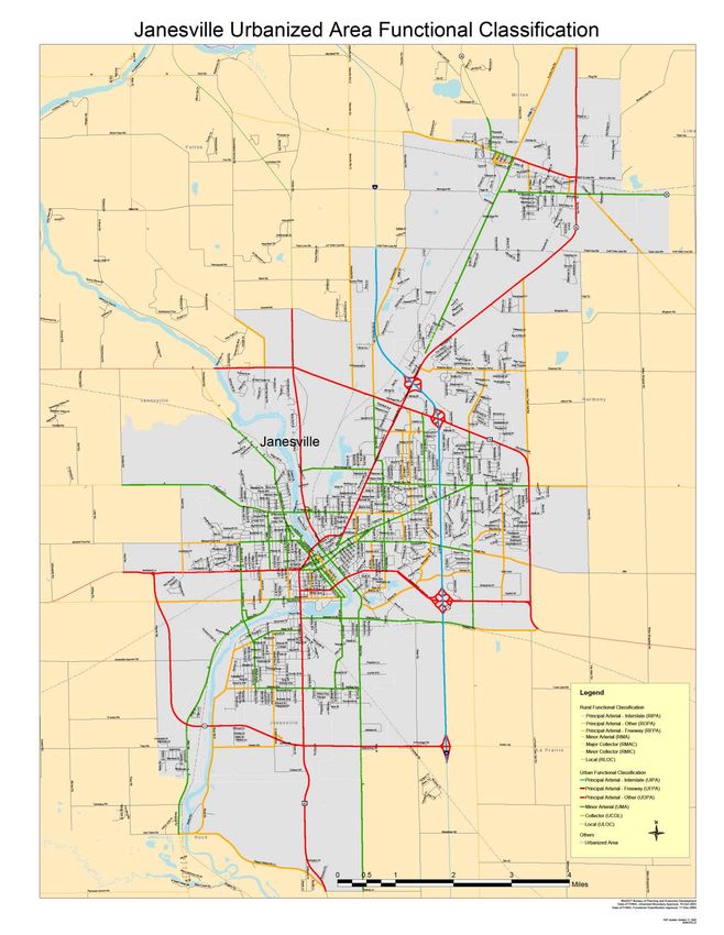
CLASSIFICATION SYSTEM
A hierarchical system of urban streets and rural roads serves the Janesville planning area. A roadway
is classified according to its function, population served, the type of surrounding land uses, average
daily traffic volumes, and whether its primary purpose is to provide mobility or access. Streets with a
high classification, such as interstates or principal arterials, primarily serve through trips or cross-town
movement. These routes are often designated as limited access roadways, carrying the areas highest
levels of traffic. Intermediate classifications, such as minor arterials or collectors, provide
connections between principal arterials and local streets. Local streets serve adjoining lands and
function primarily as access routes to and from residential neighborhoods to higher density
commercial and industrial land uses. The role of mobility and land access in the classification system
are illustrated in Table 2.
Streets & Highways
2015-2050 Janesville Area Long Range Transportation Plan 6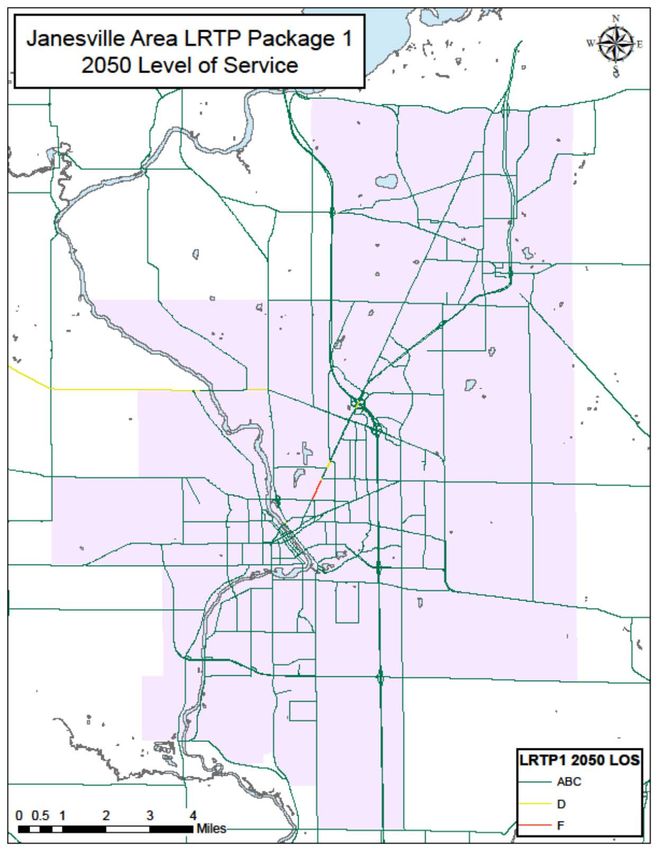
Janesville Area Metropolitan Planning Organization

                                 Table 2: FUNCTIONAL CLASSIFICATION

                     Classification             Typical Land Access         Personal Mobility
               Principal Arterials     No direct access to property               Highest
               Minor Arterials         Limited access to property.                  High
               Collectors              Common Access to property.                Moderate
               Local Roads             Unrestricted access to property              Low

Rural principal and minor arterials provide connections within the region and throughout the state,
necessitating their development on a statewide level. Similarly, because of the nature of rural major
and minor collectors, which provide routes for inter-county and intra-county travel, these types of
roads must be developed on a countywide basis.

National Functional Classification System

The functional classification system is the process by which roadways are grouped into categories
according to the type of trips served, traffic volumes, and the types of traffic generators they provide
access to. WisDOT’s criteria, which are based on FHWA’s standards, are listed in the Facilities
Development Manual 1.

Rural Street Classification System

The rural functional classification system consists of routes that connect communities within the state.
The criteria of rural road classification are the population served, surrounding land use, distance
between road types, and average daily traffic (ADT). The items considered in classifying rural roads
are shown in Table 3 through Table 5.
.

1   www.wisconsindot.gov
Streets & Highways
2015-2050 Janesville Area Long Range Transportation Plan                                             7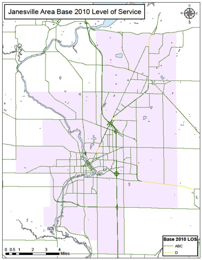
Janesville Area Metropolitan Planning Organization

                            Table 3: RURAL ARTERIAL ROAD CLASSIFICATION

     Source: Functional Classification Criteria, Wisconsin Department of Transportation; Facilities Development Manual

                          Table 4: RURAL COLLECTOR ROAD CLASSIFICATIONS

        Source: Functional Classification Criteria, Wisconsin Department of Transportation; Facilities Development Manual

Streets & Highways
2015-2050 Janesville Area Long Range Transportation Plan                                                                    8
Janesville Area Metropolitan Planning Organization

                               Table 5: RURAL LOCAL ROAD CLASSIFICATION

    Source: Functional Classification Criteria, Wisconsin Department of Transportation; Facilities Development Manual

Rural Principal Arterials: Principal arterials provide interregional connections.                                       These routes
generally serve urban populations or greater (populations 5,000 and over).

Rural Minor Arterials: Minor arterials work in conjunction with principal arterials to serve
moderate to large-sized places (places or clusters of communities with population of 1,000 or more),
and other traffic generators providing intra-regional and inter-area traffic movements.

Rural Major Collectors: Major collectors provide service to smaller-to-moderate sized places (those
with population of 100 or more) and other intra-area traffic generators; linking those traffic generators
to larger populations nearby.

Rural Minor Collectors: Minor collectors provide service to all remaining smaller places (generally
populations of 50 or more), link the locally important traffic generators with their rural hinterland, and
their spacing is consistent with population density so as to collect traffic from local roads and bring all
developed areas within a reasonable distance of a collector road.

Rural Local Roads: Local roads provide access to adjacent land and provide for travel over
relatively short distances on an inter-township or intra-township basis. All rural roads not
classified as arterials or collectors will be local function roads.

Streets & Highways
2015-2050 Janesville Area Long Range Transportation Plan                                                                       9
Janesville Area Metropolitan Planning Organization Urban Street Classification System In urban areas, an urban roadway classification is used. An urban area is a place or cluster of places inside an urban boundary with a population of 5,000 or more. There are four classifications of streets in urban areas: principal arterials, minor arterials, collectors, and local streets. Table 6 – Table 8 summarizes the criteria used to classify urban routes. (For more information refer to the WisDOT website’s Facilities Development Manual and Chapter 4: Highway Systems.) Under MAP-21 provisions, all urban streets classified as collector or higher are eligible for federal funding. Streets & Highways 2015-2050 Janesville Area Long Range Transportation Plan 10
Janesville Area Metropolitan Planning Organization

Figure 1 illustrates the application of the functional classification system within the MPO; Table 9
lists the classification of the roadways.

               Table 6: URBAN PRINCIPLE ARTERIAL FUNCTIONAL CLASSIFICATION

Source: Functional Classification Criteria, Wisconsin Department of Transportation

Streets & Highways
2015-2050 Janesville Area Long Range Transportation Plan                                                              11
Janesville Area Metropolitan Planning Organization
Table 7: URBAN MINOR ARTERIAL FUNCTIONAL CLASSIFICATION
Source: Functional Classification Criteria, Wisconsin Department of Transportation
Table 8: URBAN LOCAL CLASSIFICATION CRITERIA
Source: Functional Classification Criteria, Wisconsin Department of Transportation
Principal Arterials: Principal arterials serve the major economic activity centers of an urban area, the
highest ADT corridors, and regional and intra-urban trips. The long trip lengths and high ADT are
indicative of these routes being the main entrance and exit routes, and that they are often extensions of
the rural arterial system that carries people to and from the urban areas.
Minor Arterials: The main purpose of urban minor arterials is to provide traffic mobility, while
providing greater land access than principal arterials. They serve important economic activity centers,
have moderate ADT volumes, and serve intercommunity trips, interconnecting and augmenting the
principal arterial system. Due to their function, minor arterials may be stub-ended at major traffic
generators. Minor arterials should provide an urban extension of the rural collector system to the
urban area CBD and connect satellite community CBD’s with the region’s main CBD.
Collectors: Collectors provide direct access to residential neighborhoods, commercial, and industrial
areas, and serve inter-neighborhood trips while carrying a low ADT. They provide an equal amount
of mobility and land access. As the name implies, these routes collect and distribute traffic between
Streets & Highways
2015-2050 Janesville Area Long Range Transportation Plan 12Janesville Area Metropolitan Planning Organization local streets and arterials. To aid traffic circulation, collectors should be linked to other collectors and arterials, however, they may stub-end to serve isolated traffic and penetrate neighborhoods. Local Streets: The primary purpose of local streets is to serve adjacent land uses. Local streets comprise the largest percentage of street mileage in the urban area. Trip lengths on local streets are typically one-half mile or less. Streets & Highways 2015-2050 Janesville Area Long Range Transportation Plan 13
Janesville Area Metropolitan Planning Organization

            Figure 1: URBAN AND RURAL FUNCTIONAL CLASSIFICATION MAP

Streets & Highways
2015-2050 Janesville Area Long Range Transportation Plan                                          14
Janesville Area Metropolitan Planning Organization
Table 9: CLASSIFICATION OF MPO PLANNING AREA
Principal Arterial Minor Arterial Major Collector Minor Collector Collector
Rural
1 2
Rural Urban (RMA) Urban (UMA) Rural ( RMAC) Urban Rural (RMIC) Urban Rural Urban (UCOL)
Segment Segment Description Segment Description Segment Description Segment Description
I - 90 I - 90 STH 59 Afton Rd. Rockport Rd. to UAB 3 Avalon Rd. I - 39 to CTH J Not Assigned Avalon Rd. CTH J to PAB Not Assigned Not Assigned Academy St E. Court St. to Rockport Rd.
USH 14 USH 51 USH 51 Black Bridge Rd. USH 51 to STH 26 CTH A USH 14 to PAB CTH F CTH M to UAB Arch St West Court St. to Rockport Rd.
STH 26 USH 14 Court St. USH 51 to Milw aukee St. CTH A PAB to Burdick RD Austin Rd. Mineral Point Ave. to W. Court St
STH 11 STH 26 Crosby Ave Ramp Crosby Ave. St. to Afton Rd. CTH D Rd. UAB to PAB Avalon Rd. River Rd. S to Oakhill Ave. S
STH 11 Crosby Ave. S. Mineral Pt to State St. W CTH E URP to USH 14 CTH F Consolidated School Rd. to USH 14
Racine St CTH Y McCormic Dr. to High St. CTH G Sunny Ln.. to PAB CTH M / Chicago St. H-M Tow n Line Rd. to STH 59
W. Court Delavan Dr. W USH 51 to Wright Rd. CTH J CTH O to PAB 4 E. Memorial Dr. Milton Ave. to Harmony Dr.
Franklin St. N. Mineral Pt to Milton Ave CTH M east UAB to PAB Front St. Vernal Rd. to STH 59
Franklin St. S. E Court St. to Rockport Rd. CTH M w est USH 51 to UAB Garfield Ave N. E Memorial Dr to Ruger Ave
High St John Paul Rd. to UAB CTH M w est PAB to USH 51 Happy Hollow Rd. River Rd. to USH 51
Jackson St. Mineral Pt. Ave. to Kellogg CTH O Wright Rd. to USH 14 Harmony Dr. E. Memorial Dr. to Ruger Ave
John Paul Rd. High St. to STH 59 Plymouth Church Rd. PAB to CTH D Rd. Hilltop Drive. W. High St. to STH 59
Kellogg Ave Crosby Ave to Beloit Ave Rockport Rd Willow dale Rd. to Hayner Rd. Holiday Dr. STH 26 to Pontiac Dr
Kennedy Rd. USH 14 to Racine St. W. Kellogg Ave River Rd. S to Willard Ave. S
Kennedy Rd. USH 14 to STH 26 Kennedy Rd. USH 14 to H-M Tow n Line Rd.
Main St. S. / Beloit Ave. USH 51 to STH 11 Lexington Dr. N. USH 14 to Milw aukee St. E.
Milw aukee St E. UAB to USH 51 Liberty Ln.. Holiday Dr. to Mount Zion Ave.
Mineral Point Crosby Ave to Franklin Madison Ave/ CTH M Kennedy Rd. to STH 59
Mount Zion STH 26 to Wright Rd. Merchant Row Vernal to STH 59
N River St. Washington St. N to Franklin St. N. Mineral Point Ave Austin Rd. to Crosby Ave
Oakhill Ave Greenview to W. Court St Mohaw k Rd. Palmer Dr. to Lexington Dr.
Pearl St. Highland to W. Court St N John Paul Rd. STH 26 to STH 59
Pontiac Dr. N USH 14 to Milw aukee St. E. New ville Rd. J-F Tow n line rd. to USH 14
Randall Ave N. USH 26 to Racine St Oakhill Ave. S. State St. W to Avalon Rd.
Ruger Ave. E Court St. to Wright Rd. Palmer Dr. Beloit Ave. to Wright Rd.
State St W Crosby to Washington St Parkview Drive W. High St. to STH 59
STH 59 UAB to John Paul Rd. Pearl St. West Court St to Rockport Rd.
Washington St North UAB to Mineral Pt. Pontiac Dr. S Lexington Dr. to Milw aukee St.
West Memorial Dr UAB to Milton Randall Ave S. Racine St. E to Tyler St.
Willard Ave S. State St. W. to Kellogg Ave. Ringold St. Ruger Ave to Racine St.
Wright Rd. USH 14 to Delavan Dr. W. River Rd. S Afton Rd. to Crosby Ave.
Prairie Ave STH 11 to Sunny Lane River St. Franklin St to Racine St.
Rockport Rd. Hayner Rd. to Afton Rd.
Rockport Rd. USH 51 to Jackson St.
Rotamer Rd. STH 26 to Harmony Tow n Hall Rd.
Ruger Ave Wright Rd. to STH 14
Skyview Dr. Wright Rd. to Wuthering Hills Dr
Spaulding Ave USH 14 to Rotamer Rd.
Tyler St. Main St to Randall Ave. S
Vernal Ave Merchant Row to John Paul Rd.
Wuthering Hills Dr. Milw aukee St to STH 11
1. Interstate (RIPA), Freew ay (RFPA), Other (ROPA)
2. Interstate (UIPA), Freew ay (UFPA), Other (UOPA)
3. UAB- Urban Area Boundary.
4. PAB - Planning Area Boundary.
Local roads are all those not listed
Source: WisDOT
Streets & Highways
2015-2050 Janesville Area Long Range Transportation Plan 15Janesville Area Metropolitan Planning Organization
CITY OF JANESVILLE STREET STANDARDS
The City of Janesville’s street standards build upon the National Functional Classification Criteria,
incorporating city specific standards for right-of-way width, sidewalk width, on-street parking, and
pavement width. These standards were originally adopted by the City as part of the 1971 JATS Plan
and were reviewed when the 2005 Traffic Circulation Plan was prepared. The City’s standards are
described in Table 10 and depicted in Table 11.
While the basis for the City standards is functional classification, the City of Janesville’s
classifications differ slightly from the federal and state classifications in terminology and design
specifics. The following lists illustrate the differences between the classification systems.
Federal/State Functional Classification City of Janesville Standards
Principal Arterial Primary Arterial
Minor Arterial Standard Arterial
Collector Collector
Local Local
City Street Standards
The City of Janesville established standards for right-of-way width based on the City Engineer’s
recommended width for traffic lanes, parking lanes, curbs, sidewalks, and terrace areas.
Pavement width is a function of traffic volumes and parking availability.
• Travel Lane Width
o Local roads with a low traffic volumes- 10 ft. travel lane (minimum recommended
width)
o Collector and higher classifications or roads with a higher volume of traffic- 12 ft.
travel lane.
o Parking, the number of intersections, speed limit, and type of traffic control devices are
other considerations that affect the pavement width.
• On-street parking is determined by traffic volumes, adjacent land uses, and side street
access. Pavement width for parking ranges from 8ft. to 10ft.
o Collector and local streets- 8 ft. wide spaces.
o Standard arterial and higher – 10 ft. wide spaces.
• Curb width is 2 feet to curb face, and is typically used by vehicles parking on the street.
• Remaining street right-of-way is used for sidewalks and a terrace.
• Terrace
o Area reserved for telephone, cable television and utility lines, sidewalks, planting strip
and in winter it can be used for snow storage.
• Planting Strip
o Local, collector and standard arterial- 5ft. minimum.
o Primary Arterial- 7 to 10 ft.
• Sidewalks
o Recommended width of 5 ft.
The construction of five-foot wide sidewalks within the terrace is governed by
the City's sidewalk policy and recommendations from neighborhood plans.
Streets & Highways
2015-2050 Janesville Area Long Range Transportation Plan 16Janesville Area Metropolitan Planning Organization
• Bike Lanes
O See section on bike lane standards.
Table 10: CITY OF JANESVILLE GENERAL STREET STANDARDS
Min.
Functional ROW Width
Design Suggested Design Features
Classification /(Pavement Width)
Speed
D) Urban Expressway 100' min.-120' des./ 45 mph 4-6 lanes; no parking (divided roadway).
- Primary Arterial (56'- 80') Limited access, signals at major
intersections. Left turn accommodations.
Requires min. of 5' wide sidewalk. On-
street bicycle facilities discouraged
E) Primary Arterial or 80' min.-100' des./ 35-45 mph 4 lanes; no parking. Limited direct
Standard Arterial (52'-56') access. Signals at major intersections.
Left turn accommodations. Min. 5' wide
detached sidewalks. Bicycle facility:
wide curb lanes or bike lanes.
F) Standard Arterial 80' min.-100' des./ 30-40 mph 2-4 lanes; parking one or both sides.
(28’ - 48') Left turn accommodations. Limited
direct access. Signals where needed,
stop signs on side streets. 10' wide min.
planting strip with 5' wide detached
sidewalks. Bicycle facility: wide curb
lanes or bike lanes.
G) Standard Arterial 66' min.- 80' des./ 30-40 mph 2 lanes; parking. Left turn
(28’ - 44') accommodations. Signals where needed,
stop signs on side streets. 5' wide min.
planting strip with 5' wide detached
sidewalks. Bicycle facility: wide curb
lanes or shared roadway. Limited direct
access drives.
H) Standard Arterial 66' min.- 80' des./ 25-35 mph 2 lanes; parking. Left turn
or Collector (28’ - 40') accommodations. Stop signs on side
streets. 7' wide min. planting strip with
5' wide detached sidewalk. Bicycle
facility: wide curb lane or shared
roadway. Limited direct access drives.
I) Local 60' min.-70' des./ 25 mph 10’ – 15’ terrace. 5' wide detached
(28’-36’) sidewalk. Bicycle facility: shared
roadway. Parking.
Source: 1983 Transportation Analysis Base Study Series; 1987-2005 Traffic Circulation Plan
Streets & Highways
2015-2050 Janesville Area Long Range Transportation Plan 17Janesville Area Metropolitan Planning Organization
Table 11: GENERAL STREET STANDARDS
Note: Gutter pan on D-I is 2.0’
Streets & Highways
2015-2050 Janesville Area Long Range Transportation Plan 18Janesville Area Metropolitan Planning Organization
Narrow Street Standards
Narrow street standards (also known as skinny streets) is an approach to residential development that
provides roadway design flexibility and supports residential livability. The City of Janesville passed a
narrow street ordinance in 2006. Janesville residential streets are typically 36 ft. (curb face to curb
face) with a 70 ft. right-of-way width; the narrow street standard is 28 ft. (curb face to curb face) with
60 ft. or less of right-of-way. 2 Street width less than 28 feet may be considered with restricted street
parking, or if access is limited from physical or topographical challenges and limitations. Land uses
served by narrow streets are low-density residential areas consisting of single-family housing; with
limited two-family housing (if it does not diminish the characteristics of the neighborhood) allowed
only by a conditional use permit. 3 The residential zoning ensures the characteristics of these
neighborhoods are able to maintain residential charm of open green space, restricted multi-family
housing and limited two family housing, and limited non-local traffic.
Narrow streets support residential neighborhoods by providing the benefits of:
• Calms (slows) traffic
• Discourages non-local traffic
• Promotes walking and biking
• Creates neighborhood identity
• Preserves green space
Narrow streets tend to be less expensive to build and maintain overall than a standard width residential
street due to the reduced width of the street. Cost savings are proportional to the reduced road width
from a standard 36 feet (curb face to curb face) street to a narrow street, approximately 20% savings
depending on road width. Additionally, based on the 1994 assessment from reducing street standard
width to 28 feet is $19.00 from $26.00. A lot width of 110 feet would be assessed $2,860 for standard
street width compared to $2,090 for a narrow street (savings of $715). Overall, the maintenance
required by the City is lower due to the reduced need for multiple passes on the street to maintain
streets clear of debris and snow. Rehabilitation of narrow streets would also cost less due to the
reduced width.
An environmental benefit of constructing narrow streets is the reduction of stormwater runoff. The
effects of impervious surfaces, especially in urbanized areas, are the increased pollutants into
waterways from surface runoff. Runoff increases erosion and reduces bank stability, rapid rates of
temperature changes, and alters the organic biology by introducing or restricting movement of
pollutants or sediments and nutrients. With narrow streets, the total street footprint is much less than a
traditional street reducing the overall negative environmental effect.
The narrow street ordinance presents a unique opportunity for real estate developers. Along with the
R1 zoning (new single-family housing) developers can reduce their financial burden from reduced
roadway material cost and the need to clear large amounts of land.
City of Janesville Narrow Street Examples:
• Benton Avenue (between Milton Avenue and Ringold Street) is an example of a narrow
street with a road width of 28 ft. (curb face to curb face) and right-of-way of 40 ft.
• Bennett Avenue (directly south of Benton) is 29 ft. (curb face to curb face) with a 50 ft. of
2 City Ordinance 17.40.065 Street Width Applications
3 City Ordinance 18.36.020 Residence Districts, Section B: R1 – Single-Family and Two-Family Resident District
Streets & Highways
2015-2050 Janesville Area Long Range Transportation Plan 19Janesville Area Metropolitan Planning Organization
right-of-way.
• Sherman Avenue (directly south of Bennett) is wider than a typical narrow street at 30 ft.
(curb face to curb face) with a 66 ft. right-of-way
• North Walnut Street is 28 ft. (curb face to curb face) with a 50 ft. right-of-way. From Ravine
to Mineral Point Avenue, parking is restricted for one block.
• Forest Park Boulevard (between Ruger Avenue and East Court Street) has a 26 ft. (curb
face to curb face) with a 50 ft. wide right-of-way.
Safety Conversions
The Bicycle & Pedestrian Section identifies three roadways in Janesville that may benefit from a road
reconfiguration a.k.a. safety conversion. A safety conversion refers to the reconfiguration of a
roadway from a four lane undivided roadway to two driving lanes, a two-way left turn lane (TWLTL,
pronounced “Twiddle”), and either bike lanes or a lane of parking. Some of the potential benefits of a
three lane TWLTL over the current four lane undivided road are:
• Improving safety for bicyclists.
• Improving speed limit compliance and decreasing crash severity when crashes do occur.
• The two-way left turn lane reduces the number of mid-block and intersection conflict points
thereby reducing rear-end and side swipe crashes.
• The two-way left turn lane can be used by vehicles traveling in either direction for
deceleration and refuge while making a midblock left turn maneuver.
• The two-way left turn lane can be used as an acceleration lane for vehicles turning left to enter
the street from mid-block driveways.
• The two-way left turn lane can allow for easier and safer emergency vehicle movement,
particularly during peak hour periods.
• Conventional exclusive left and right turn lanes remain at major intersections.
A potential disadvantage of the TWLTL is the possibility of slightly increased delays and backups at
signalized intersections during peak hour traffic periods because the TWLTL maintains only one lane
of thru traffic. However, the benefits of converting from a four lane undivided roadway to a three lane
TWLTL have been found to outweigh the potential peak hour delays.
The conversion from a four lane undivided roadway to a three lane TWLTL has been successfully
made in multiple communities in Wisconsin and across the United States over the last several
decades. Conversions of streets with Average Daily Traffic (ADT) less than 17,500 vehicles have
been found to adequately handle traffic, reduce accidents, and improve bicycle and pedestrian safety
on streets with multiple residential driveways and commercial accesses.
The Bicycle & Pedestrian Section suggested the study of three roadways in Janesville. These
roadways are recommended for further study and evaluation in the Streets & Highways Section.
Streets & Highways
2015-2050 Janesville Area Long Range Transportation Plan 20Janesville Area Metropolitan Planning Organization
CITY OF MILTON STREET STANDARDS
The City of Milton’s street standards build upon the National Functional Classification Criteria, incorporating city specific standards for right-
of-way width, sidewalk width, and pavement width. The City of Milton’s street standards are listed below in and have been adopted as part
of their current city code.
Table 12: MILTON'S STREET STANDARDS
Cul-De-Sac Temp (5) Dead End
Pvmnt (1) Lane Sidewalks Min. Ret. Min. Rvrs/Curve NEX.
Description ROW Max Pvmnt Max Pvmnt
Width Width (3) Radius Radius Tangent Grade (4) ROW Dis.
Length Width Length Width
Arterials 100’ 48’ 12’ 2 30’ 450’ 150’ 9% -- -- -- -- 1,000’ 44’
Collector (2) 80’ 36’ 36’ 2 20’ 450’ 150’ 9% -- -- -- -- 1,000’ 30’
Industrial 80’ 36’ 12’ Optional (3) 30’ 320’ 150’ 9% 600’ 120’ -- -- 1,000’ 36’
Local 66’ 28’ 10’ 2 20’ 200’ 100’ 9% 600’ 120’ -- -- 2,000’ 28’
Frontage 50’ -- -- Optional (3) -- -- -- -- -- -- -- -- -- --
Alleys 25’ 18’ -- None 10’ -- -- -- -- -- -- -- -- --
1. Pavement width without curb and cutter (edge of pavement to edge of pavement).
2. If a vertical curve is under 500’ radius, the maximum grade allowed is 5% minus, 0.5% for each 50’ radius under 500’.
3. Requirements to be determined by the Plan Commission.
4. Minimum street grade 0.5% - Shall not exceed standards, unless necessitated by topography and approved by City Council upon recommendation by City Engineer.
5. “T” turnaround my be used. Turnaround shall extend a minimum of 20’ behind the back of the curb on the permanent street and be 20 ‘ wide. Turnaround shall be paved.
Streets & Highways
2015-2050 Janesville Area Long Range Transportation Plan 21Janesville Area Metropolitan Planning Organization
BIKE LANE STANDARDS
Bike lane standards are based on the Wisconsin Bicycle Facility Design Handbook 2004 and are meant
as general guidelines only. Illustrations of suggested lane and shoulder widths are provided in the
Bicycle and Pedestrian Section of this plan.
Rural Areas
In rural areas, a paved shoulder is normally provided in lieu of a dedicated and striped bike lane. The
standard paved shoulder is built to depend on actual vehicle and bicycle ADT, or the recommended
bicycle ADT expected on the route. On roadways with very low ADT, less than 700 vehicles per day,
there will typically be adequate facility space for bicycles and motorized vehicles to share the existing
roadway.
Table 13: RURAL STATE HIGHWAY BIKE LANE WIDTHS
Rural Two-Lane State Trunk Highway Paved Shoulder Width Requirements to Accommodate Bicycles
Bicycle ADT (or Expected ADT)
Motor Vehicle ADT
0-24 25 1
Under 700 0 ft 2 0 ft 2
700 - 1500 0-3 ft 2 4 ft 3
1501 - 3500 3 ft 2 5 & 6 ft 2, 5
3501 4, 4 ft 2 5 ft 2, 4, 5
(1) 25 bicycles per day (existing or expected) OR the ADT recommended for the planned route.
(2) For roadways that do not meet the bicycle ADT requirement, a 3 ft. (0.9 m) shoulder should typically be provided.
However, for roadways with ADTs over 3500, a minimum of a 4 ft. (1.2 m) paved shoulder is highly recommended.
(3) 3 ft. (0.9 m) is acceptable where shoulder widths are not being widened and/or vehicle ADT is close to the bottom of
the range.
(4) When ADTs exceed 4,500, a 6 ft paved shoulder is advisable.
(5) A 6 ft. paved shoulder may be highly desirable for maintenance purposes since this class calls for 6 ft. gravel
shoulders. Paving the shoulders entire width is often preferred over leaving only 1 ft. of gravel shoulder.
Source: WisDOT, Wisconsin Bicycle Facility Design Handbook, 2004, minor updates in 2006 and 2009
NOTE: Additional resources for planning rural bicycle routes are available from WisDOT. Notably,
Planning for Rural Bicycle Routes and the WisDOT Guide to Rural Bicycle Facilities.
Streets & Highways
2015-2050 Janesville Area Long Range Transportation Plan 22Janesville Area Metropolitan Planning Organization
Urban Areas
In urban areas, bike lanes should be on the right side of the street in most cases, and adequately
marked or signed so they are not mistaken for additional vehicle travel lanes or parking areas. The
lane widths recommended in Table 14 are minimums, and may not be sufficient in high use areas,
when the adjacent traffic lane is less than 11 ft. wide, on high-speed facilities where wider shoulders
are warranted or when the lane is shared with pedestrians. In general, the minimum combined width
of bicycle and parking lanes should be approximately 13 ft. This is to allow for adequate room for
bikers to maneuver around poorly parked vehicles and opening doors. When bus and bike lanes are
combined the bike lane should be to the left of the bus lane so buses can easily pull to the curb.
Table 14: URBAN ROADWAY BIKE LANE WIDTHS
Urban Roadway Paved Shoulder Width Requirements to
Accommodate Bicycles
Bike Lane
Street Type Width
Curbed asphalt or concrete, no parking 4 ft 1, 6
Curbed concrete street, integral curb, no parking 5 ft 2
Curbed street, parking 5 ft 3, 4
No curb, speeds 35 mph 5 ft 5
No curb, speeds < 35 mph 4 ft 5
All measurements are minimum suggested widths.
1. Measured from inside the stripe to the joint line of the gutter
pan.
2. Measured from face of curb to the inside of the bicycle lane
stripe.
3. May be wider if parking volumes or parking turnover is high
4. Assumes a 8 to 10 ft. parking lane.
5. Assumes these are not rural roadways. Rural roads have their
own standards.
6. Not including gutter pan.
Source: WisDOT, Wisconsin Bicycle Facility Design Handbook, 2004.
Bicycle lane standards are designed to be flexible in order to adapt to various road geometries. Figure
2 shows the possible configurations of bike lane widths. The preferred width is a 1’-2’ curb and gutter
pan with a 5’ bike lane.
Streets & Highways
2015-2050 Janesville Area Long Range Transportation Plan 23Janesville Area Metropolitan Planning Organization
Figure 2: URBAN CROSS SECTION DIMENSIONS
CURRENT TRANSPORTATION ISSUES
Congestion
The I-39/90 corridor has the most serious congestion issues in the Janesville area. Traffic is heavy
particularly on weekends during the tourist season. Few other streets or highways in the planning area
experience congestion. The commercial areas along Milton Ave./STH 26 and Humes Rd./USH 14
experience some delay because there are many traffic signals (and one at-grade rail crossing) along
the corridors, although they are not considered congested from a capacity definition.
Rail Transportation
Although the focus of this chapter is highways and streets, rail lines affect traffic flow along major
streets such as West Court Street, Delavan Drive, USH 51 and USH 14 in Janesville and John Paul
Road and Janesville Street in Milton where at-grade crossings are located. Trains sometimes block
these intersections for long periods, creating delay and congestion. Trains delay emergency response
vehicles, which is a particular issue in Milton where the city is bifurcated by rail line. There are no
grade-separated crossings in Milton to allow vehicles north-south access.
The Union Pacific and Wisconsin & Southern railways serve the City of Janesville and Wisconsin &
Southern serves the City of Milton. The Wisconsin & Southern railroad uses Janesville as the hub
from which they serve south central Wisconsin and northern Illinois. The Janesville area utilizes rail
primarily to haul manufacturing components and agricultural commodities. In several locations
within the urban area, abandoned track has been converted into mixed-use recreation trails. A map of
Janesville’s existing rail lines and specific rail related issues are addressed in the Freight section of
this plan.
Streets & Highways
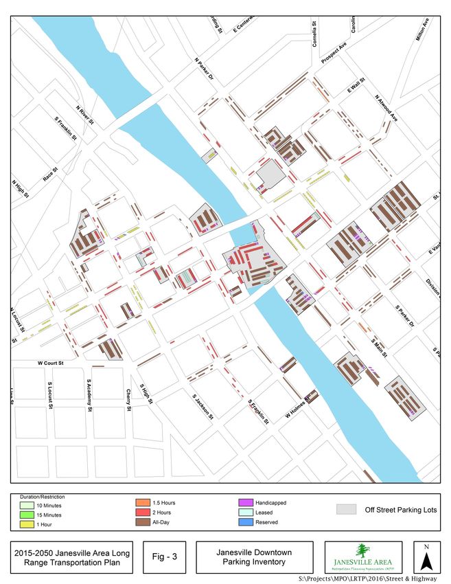
2015-2050 Janesville Area Long Range Transportation Plan 24Janesville Area Metropolitan Planning Organization Parking The majority of the street network within the urbanized area is designed to provide at least one lane of parking. The availability of on-street parking relates to the design standards, functional classification, and speed limit of each street. On-Street Parking On-street parking can act as a traffic calming measure (if certain conditions are met such as high parking occupancy) by reducing vehicle speeds by narrowing the perceived roadway and necessitating that drivers be aware of other vehicles and pedestrians entering or leaving the roadway. In the City of Janesville, on-street parking is restricted on several of the City’s major arterials. The commercial development along major arterials where parking is restricted provides ample off-street private parking for consumer needs. On-street parking is more common along streets with lower average daily traffic and in business areas that developed during the City of Janesville’s inception. In Janesville’s Downtown short-term on- street parking is currently a necessity for the offices and businesses located there. In residential neighborhoods with limited through traffic on-street parking is also common. Public Parking The largest capacity public parking lot in the MPO is the Parker/Wall ramp in Downtown Janesville completed in 2010, located at the southwest corner of North Parker Drive and East Wall Street. The ramp provides 234 parking spaces with an occupancy rate of 41%, as of the most recent spring 2015 parking study. 4 Before the completion of the Parker/Wall ramp, the Parking Plaza provided the highest capacity of public parking lot. At the time of the 2015 parking study, the Parking Plaza contained 176 parking spaces. Approximately 150 parking spaces were unavailable or restricted due to structural deterioration or construction activities occurring adjacent to the parking deck. The Parking Plaza is scheduled to be removed in late 2016 due to the deteriorating state of the structure. Figure 3 provides a map of Janesville’s 2015 parking inventory. The MPO is expecting to spread the loss of parking spaces created from the removal of the Parking Plaza throughout Downtown Janesville. The Parker/Wall ramp is expected to take on the largest numbers of vehicle parking increasing from its 42% and opening the top floor for parking, which currently is closed off. Other off-street public lots in the vicinity are underutilized. In 2015, including the Parking Plaza, the downtown parking occupancy rate was 51%; without the Parking Plaza the downtown parking occupancy rate would still only be 59% used. Overall, Downtown Janesville parking availability should not be greatly affected with the Parking Plaza removal. 4 Janesville Area Metropolitan Planning Organization, Downtown Parking Study, Janesville, WI 2015. Streets & Highways 2015-2050 Janesville Area Long Range Transportation Plan 25
You can also read